In Search of the Wyatt Chapel Cemetery Boundaries. Rice University Visiting Graduate Students Bill Baker Jared Sallee July 2010
|
|
|
- Byron Hampton
- 5 years ago
- Views:
Transcription
1 In Search of the Wyatt Chapel Cemetery Boundaries Rice University Visiting Graduate Students Bill Baker Jared Sallee July 2010

2 Review of Aerial Photographs

3 Review of Aerial Photographs
4 Review of Aerial Photographs
5 Vegetation in Aerial We noted that the 1930 view had the least vegetation. This indicates the plant succession of the area over 76 years. There are 5 stages of plant succession: Herb stage Shrub stage Young Forest stage Mature Forest stage Climax Forest stage Photographs
6 Data Analysis We superimposed the tree data over the 1930 aerial photograph to try to identify a vegetative boundary. We plotted the vegetative boundary alongside the creek. We identified two evergreen trees that we believe mark the entrance to the original slave cemetery. We plotted known burial sites inside the vegetative boundaries to compare against the proposed cemetery boundaries.
7 Vegetative Boundary Superimposed Over 1930 Map
8 Evergreen Entrance Superimposed Over 1930 Map Evergreen Tree Evergreen Stump
9 Existing Oak Trees & Stumps Superimposed Over 1930 Map Corner post by creek By Duckworth Plot


10 Existing Grave Markers Superimposed Over 1930 Map Corner post by creek Evergreen Tree Evergreen Stump By Duckworth Plot
11 Conclusions It appears that there is an oval-shaped vegetative boundary marking the cemetery plot. It appears that two evergreen trees were planted (one is a stump) near the corner post of the northwest boundary near the creek. We did not locate any other evergreens in the plot area. The two evergreen trees were the oldest trees in the plot and mark the original slave plot. In the northwest corner, bottles, broken dishes, and rocks were found. These items have been used in the past to mark slave graves. We believe that the oak trees were planted in a pattern at a later time shortly before The pattern was plotted to establish the boundaries of the cemetery plot. We do not feel comfortable at this time establishing the southwest boundary due to the tremendous amount of vegetation found near the creek.
12 Recommendations Continue removing existing brush so that debris, stones, pottery, and impressions can be studied next summer. Work with Prairie View A&M to better define the boundaries of the cemetery. We were told that an old plot map existed but it was not available to be integrated into this project. Due to the tremendous amount of vegetation on the northwest boundary of the cemetery plot moving toward the creek, we were unable to establish a vegetative boundary.

13 A New Fence Line Running the Distance Summer 2010 Jan Grout and Sarah Wall
 line was run along the tree line in the front clearing area to the main clearing to determine if any anomalies would impede the building of a civil war style fence. 2.")
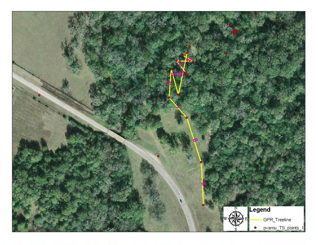
14 Problem: Are there any anomalies in the subsurface along a proposed fence line in the Wyatt Chapel Cemetery Area? What was done: 1. A GPR (Ground Penetrating Radar) line was run along the tree line in the front clearing area to the main clearing to determine if any anomalies would impede the building of a civil war style fence. 2. A visual observation was made to look for any obstacles that would prevent the building of a fence. Survialistboard.com

15 The yellow indicates the area of data collection.


16 Results Many shallow anomalies were found which are believed to be tree roots. Letspaintnature.com Earthideaslandscaping.com

17 Why Tree Roots Backyardnature.net Water Oaks (Quercus Nigra) are the most common tree found along the line. The average Water Oak will grow 50 to 80 with a spread of 60 to 70. The root system of the water oak is shallow and widespread. The spread will be roughly the same as the tree canopy. The GPR showed shallow anomalies that would be consistent with tree roots.

18 A Water Oak toppled by a storm. Notice the extensive root system. forums2.gardenweb.com
19 Anomaly Along GPR Line 5 An anomaly along GPR Line was found. A profile was observed that could possibly be the historic creek channel for Pond Creek. Historically the creek has moved North to Northwest based on aerial photographs and GPS data from Summer 2009.
20


21 Start of Tree line Line 5
22 Visual Inspection of Site The area has been used for dumping in the past. This is evident by broken glass bottles, plates and other debris that can be observed at the surface. Bricks and concrete that are not part of the cemetery have also been dumped in parts of this site. GPR lines over area s of debris also are consistent with buried glass and bricks.


23 Recommendations Centerforinvestigativereporting.org There are many shallow, large tree roots that will have to be worked around when putting in the fence post. Care to avoid cutting through many of the roots from the same tree should be taken. If too many of the roots are destroyed the tree will die. There are many areas where dumping and litter has taken place. These need to be approached with care, avoiding broken glass and sharp edges. The clearing going into the central cemetery area has not shown any noticeable anomalies. Walkways that meet ADA requirements could be made to access existing headstones.
24 Acknowledgements Dr. Akel Kahera Dr. James Wilson Kenneth Grimes, Jr. Phyllis Earles Christi Landry
SITE SUMMARY REPORT Arlington Dump NONCD Yadkin County
 SITE SUMMARY REPORT Arlington Dump NONCD 0000644 Yadkin County Hurricane Recovery Act of 2005 State of North Carolina State Contract N06009S Schnabel Project No. 06210002.15 July 31, 2009 Prepared for:
The Corhaven Graveyard Project
 The Corhaven Graveyard Project March 31, 2016 Coracle 2883 Quicksburg Road Quicksburg, VA 22847 inthecoracle.org Executive Summary Coracle is a nonprofit organization based in the Shenandoah Valley of
CITY OF MIAMI CEMETERY 1800 N.E. 2 AVENUE
 CITY OF MIAMI CEMETERY 1800 N.E. 2 AVENUE Designation Report City of Miami REPORT OF THE CITY OF MIAMI PLANNING DEPARTMENT TO THE HERITAGE CONSERVATION BOARD ON THE POTENTIAL DESIGNATION OF CITY OF MIAMI
IS THERE MONEY AVAILABLE FOR WORK IN HISTORIC CEMETERIES? The AHC is not aware of any funding available for cemetery preservation or maintenance.
 ALABAMA HISTORICAL COMMISSION The State Historic Preservation Office Voice: (334)242-3184 Fax: (334)262-1083 www.preserveala.org ALABAMA HISTORIC CEMETERY REGISTER WHAT IS THE ALABAMA HISTORIC CEMETERY
HISTORIC TEXAS CEMETERY REQUEST FOR DESIGNATION
 HISTORIC TEXAS CEMETERY REQUEST FOR DESIGNATION List additional descriptions or information on separate pages, if necessary. IDENTIFYING INFORMATION Primary name: Also known as: County: Type: Single grave
PROJECT ASSIGNMENT: DESIGNING AND DRAWING A PLANTATION
 NAME: DATE: PERIOD: D irections This assignment asks you to design and draw a southern plantation on a piece of poster board. This project will allow me to see that you understand how the plantation system
The Archaeology of Gardening at Amache Summary Report-Summer Bonnie J. Clark, University of Denver Prepared for Dumbarton Oaks, August 2011
 The Archaeology of Gardening at Amache Summary Report-Summer 2010 Bonnie J. Clark, University of Denver Prepared for Dumbarton Oaks, August 2011 Introduction During World War II, over 120,000 people of
10.10 Diamond Harbour Memorial Gardens Cemetery
 10.10 Diamond Harbour Memorial Gardens Cemetery Cemetery Character Diamond Harbour Memorial Gardens Cemetery was officially opened in May 2002. The cemetery is designed in terraces in accordance with the
3.13. Development Guidelines
 3.3 Landscaping Elements Landscaping should be used to frame and soften structures, define site functions, enhance the quality of the environment, and screen undesirable views. Safety, environmental impacts,
Urban Conservation Practice Physical Effects ESTABLISHMENT, GROWTH, AND HARVEST NUTRIENT MANAGEMENT
 NOT WELL 800 - Urban Stormwater Wetlands A constructed system of shallow pools that create growing conditions for wetland plants to lessen the impacts of stormwater quality and quantity in urban areas.
Project Location. Jay and Patty Baker Park and Gordon River Greenway Connector Bridge. Naples Beach Golf Club. Gordon River. East. Naples.
 Gordon River Project Location Naples Beach Golf Club East Naples Naples Naples Bay Evergreen Golf and Country Club and Gordon River Greenway Connector Bridge Gordon River Greenway CONNECTOR BRIDGE AND
L 2-1 HERITAGE REPORT: REASONS FOR HERITAGE DESIGNATION. Cheyne Family Cemetery. Main Street South
 L 2-1 HERITAGE REPORT: REASONS FOR HERITAGE DESIGNATION Cheyne Family Cemetery Main Street South October 2013 L 2-2 PROFILE OF SUBJECT PROPERTY: Municipal Address Main Street South (Lot 14, Con 1, EHS)
WATER QUALITY IMPACT ASSESSMENT (WQIA) FORM
 FORM") WATER QUALITY IMPACT ASSESSMENT (WQIA) FORM Name: CCW Development Associates, L.L.C. Street Address: Telephone Number(s): 1209 Laskin Road, Virginia Beach, VA 23451 (757) 491-1996 Email: chris@vbhomesliving.com
WATER QUALITY IMPACT ASSESSMENT (WQIA) FORM Name: CCW Development Associates, L.L.C. Street Address: Telephone Number(s): 1209 Laskin Road, Virginia Beach, VA 23451 (757) 491-1996 Email: chris@vbhomesliving.com
St. Elizabeths Hospital/West Campus Landscape Character-Defining Features
 The following list of landscape character-defining features is taken directly from Chapter VII of the 2007 St. Elizabeths West Campus Cultural Landscape Report by Heritage Landscapes and Robinson & Associates,
Photo 1: Upper Rock Creek Trash, east of Ogontz Ave. Map 1: Map of Upper Rock Creek with photos of conduit openings
 Philadelphia and Cheltenham Litter Polluting Upper Rock Creek Kelly O Day Litter from the Wadsworth shopping area, Cheltenham Avenue, Limekiln Pike, Ogontz Avenue and the 3 large Cheltenham shopping malls
CORPORATE POLICY CEMETERY OPERATION AND MAINTENANCE
 POLIC STATEMENT CORPORATE POLIC CEMETER OPERATION AND CEMETER OPERATION AND This policy provides guidelines for the effective and efficient operation of Pioneer Cemetery. The establishment of this policy
Triangle Land Conservancy Conservation Area Monitoring Report Carolina North
 Triangle Land Conservancy Conservation Area Monitoring Report Carolina North Property Name: Bolin Creek West Conservation Area Date of visit: April 11, 2018 County: Orange Property Type: Restrictive Covenants
L 4-1. Heritage Report: Reasons for Heritage Designation. Kodors House. 35 Rosedale Avenue West
 L 4-1 Brampton Heritage Board Date: January 17, 2012 Heritage Report: Reasons for Heritage Designation Kodors House 35 Rosedale Avenue West December 2011 1 L 4-2 Profile of Subject Property Municipal Address
Triangle Land Conservancy Conservation Area Monitoring Report Carolina North
 Triangle Land Conservancy Conservation Area Monitoring Report Carolina North Property Name: Bolin Creek West Conservation Area Date of visit: 2.18.13, 2.18.13, 3.13.13, and 6.10.13 County: Orange Property
Specifications for Investigation and Perpetuation of U.S. Public Land Survey Corners
 Specifications for Investigation and Perpetuation of U.S. Public Land Survey Corners John M. Thornton State Land Surveyor January 12, 2016 SPECIFICATIONS FOR INVESTIGATION AND PERPETUATION OF U. S. PUBLIC
Homeowners Guide to Stormwater BMP Maintenance
 Homeowners Guide to Stormwater BMP Maintenance What You Need to Know to Take Care of Your Property Rain Barrel Dry Well Rain Garden Pervious Asphalt Porous Pavers City of El Monte Stormwater BMP Management
This document provides an overview and methodology for properly marking out embedments found with Ground Penetrating Radar (GPR).
.") Best Practice Title: Issue No.: : June 12, 2014 Introduction This document provides an overview and methodology for properly marking out embedments found with Ground Penetrating Radar (GPR). Due to significant
Best Practice Title: Issue No.: : June 12, 2014 Introduction This document provides an overview and methodology for properly marking out embedments found with Ground Penetrating Radar (GPR). Due to significant
Urban Design Brief Woodland Cemetery Funeral Home 493 Springbank Drive
 Urban Design Brief Woodland Cemetery Funeral Home The Incorporated Synod of the Diocese of Huron April 15, 2016 Urban Design Brief April 15, 2016 TABLE OF CONTENTS Page No. INTRODUCTION... 1 SECTION 1
CIVIL WAR MEMORIAL ASSESSMENT FORM
 Print Form FORM CWM #61 PAGE 1 OF 4 NATIONAL ORGANIZATION SONS OF UNION VETERANS OF THE CIVIL WAR CIVIL WAR MEMORIAL ASSESSMENT FORM PLEASE: Type or print, using a ball-point pen, when filling out this
MARBLE RIVER WIND POWER PROJECT Agricultural Protection Measures
 MARBLE RIVER WIND POWER PROJECT Siting Considerations 1. Locate access roads and, to the extent allowed by local laws, wetlands and topography, individual wind turbines and other structures along field
Appendix 1: Site Inventory Form
 Appendix 1: Site Inventory Form Wapsi Valley Archaeology, Inc. Anamosa, IA 56 X Cemetery Washington 83 24 2 NE X 1 5 approx. 200 approx. 201 unknown unknown Historic Resources Evaluation: 07A: Cemetery
Kittson Parkway / Watershed Park Parking Lot
 Kittson Parkway / Watershed Park Parking Lot Date Constructed: Summer 2005 Site Location / Description: Kittson Parkway, North Delta, British Columbia. Permeable parking lot adjacent to Watershed Park;
TOWN OF MISHICOT CEMETERY RULES
 TOWN OF MISHICOT CEMETERY RULES Progressive Farmers St. John=s Saxonburg German Methodist The cemetery authorities will not be responsible for any damages done to the lots or structures thereon, or for
Triangle Land Conservancy Conservation Area Monitoring Report Carolina North
 Triangle Land Conservancy Conservation Area Monitoring Report Carolina North Property Name: Bolin Creek West Conservation Area Date of first visit: 3.12.14 County: Orange Date of second visit: 6.5.14 Property
HISTORIC DISTRICT COMMISSION MINUTES OF MARCH 18, 2015 Municipal Building Commission Room 151 Martin, Birmingham, Michigan
 HISTORIC DISTRICT COMMISSION MINUTES OF MARCH 18, 2015 Municipal Building Commission Room 151 Martin, Birmingham, Michigan Minutes of the regular meeting of the ( HDC ) held Wednesday, March 18, 2015.
PROJECT INFORMATION. The type of development
 A LETTER OF RECOMMENDATION (WITH CONDITIONS) FOR THE EXEMPTION OF A FULL PHASE 1 ARCHAEOLOGICAL HERITAGE IMPACT ASSESSMENT FOR THE PROPOSED, CONSTRUCTION OF A FILLING STATION AND ASSOCIATED INFRASTRUCTURE
The Home Ignition Zone
 Dear Wisconsin Homeowner: Research has shown that the characteristics of buildings and their immediate surroundings determine the risk of ignition during a wildfire. That s why preparing your home and
Langstone Vale CREMATORIUM
 Amlosgfa Langstone Vale CREMATORIUM A4042 Ponthir M4 NEWPORT Llanhennock Caerleon B4237 Celtic Manor Resort River Usk A46 A449 JUNCTION 24 Langstone A48 Underwood Langstone Vale CREMATORIUM Bishton Llanmartin
Marlow Cemetery, Marlow
 Understanding Historic Parks and Gardens in Buckinghamshire The Buckinghamshire Gardens Trust Research & Recording Project Marlow Cemetery, Marlow 19 August 2015 Bucks Gardens Trust Association of Gardens
Experiences of dealing with Lesser Horseshoe Bats (Rhinolophus
 Experiences of dealing with Lesser Horseshoe Bats (Rhinolophus hipposideros) in Wales, UK Len Wyatt Environmental Science Advisor, Transport, Housing and Strategic Regeneration, Welsh Assembly Government,
Philadelphia Creek Trash Assessment (PCTA) Methodology Mill Run Creek Test Case
 Methodology Mill Run Creek Test Case") Philadelphia Creek Trash Assessment (PCTA) Methodology Mill Run Creek Test Case Mill Run Creek emerges from a covered creek in Philadelphia to an open creek in Cheltenham. The Creek has extensive trash
Philadelphia Creek Trash Assessment (PCTA) Methodology Mill Run Creek Test Case Mill Run Creek emerges from a covered creek in Philadelphia to an open creek in Cheltenham. The Creek has extensive trash
P A R K I M P R O V E M E N T S
 Francis Field P A R K I M P R O V E M E N T S SUBMITTED BY DC Department of Parks and Recreation 3149 16th ST NW WASHINGTON DC 20010 CONTACT: BRIDGET STESNEY Planning and Design Officer 202. 671. 0453
POTTERSPURY PARISH COUNCIL Grass Mowing and Tree & Shrub Maintenance Tender 2017
 SPECIFICATION 1. GENERAL MOWING: To mow to the satisfaction of the Parish Council the areas marked on the maps being: 1.1. Verges throughout the village including the vision splays in front of all four
CIVIL WAR MEMORIAL ASSESSMENT FORM
 Print Form FORM CWM #61 PAGE 1 OF 4 NATIONAL ORGANIZATION SONS OF UNION VETERANS OF THE CIVIL WAR CIVIL WAR MEMORIAL ASSESSMENT FORM PLEASE: Type or print, using a ball-point pen, when filling out this
ST. ELIZABETHS WEST CAMPUS CULTURAL LANDSCAPE REPORT. Chapter VI: St. Elizabeths Hospital Existing Landscape
 ST. ELIZABETHS WEST CAMPUS CULTURAL LANDSCAPE REPORT A. INTRODUCTION TO EXISTING LANDSCAPE This chapter describes the character of the existing St. Elizabeths Hospital landscape. Combined with the accompanying
What is happening? OPENING. Goals for Today WE ARE HERE. STEP 1 Online Questionnaire. STEP 2 Preliminary Design. STEP 3 Public.
 PUBLIC INFORMATION SESSION WCOME What is happening? The Vancouver Board of Parks and Recreation is working to improve the quality of children s play experiences throughout the city. The Park Board is collaborating
Tookany Creek Watershed Trash Pollution Update Photographic Trash Surveys Jan- Mar, 2013
 Tookany Creek Watershed Trash Pollution Update Photographic Trash Surveys Jan- Mar, 2013 Tookany Creek Surveys 1. Cedarbrook Plaza and Upper Rock Creek 2. Cheltenham Mall and Upper Rock Creek 3. Cedarbrook
PHASE 1 ARCHAEOLOGICAL IMPACT ASSESSMENT PROPOSED DEVELOPMENT ERF 3 ROBERTSON WESTERN CAPE PROVINCE
 PHASE 1 ARCHAEOLOGICAL IMPACT ASSESSMENT PROPOSED DEVELOPMENT ERF 3 ROBERTSON WESTERN CAPE PROVINCE Prepared for BOLAND ENVIRO Att: Mr Nik Wullschleger PO Box 250 Worcester 6849 Fax: (023) 347 0336 By
FORM CWM #61 Page 1 . NATIONAL ORGANIZATION SONS OF UNION VETERANS OF THE CIVIL WAR CIVIL WAR MEMORIAL ASSESSMENT FORM
 FORM CWM #61 Page 1. NATIONAL ORGANIZATION Type of Memorial (check all applicable) Monument with Sculpture without Sculpture with Cannon standalone Cannon Historical Marker Plaque Other ( flag pole, G.A.R.
Exploring Abergavenny
 11 Majors Barn36 Ysguborwen Exploring Abergavenny 2 ysguborwen EXPLORING ABERGAVENNY For several years the Abergavenny and District Civic Society has been studying the streets, spaces and buildings of
CIVIL WAR MEMORIAL ASSESSMENT FORM
 Print Form FORM CWM #61 PAGE 1 OF 4 NATIONAL ORGANIZATION SONS OF UNION VETERANS OF THE CIVIL WAR CIVIL WAR MEMORIAL ASSESSMENT FORM PLEASE: Type or print, using a ball-point pen, when filling out this
to the Jericho Reservoir Project Open House
 Welcome to the Jericho Reservoir Project Open House is responsible for supplying clean, safe drinking water to over 2.4 million residents in the region. Operating our vast drinking water system with a
Monument Memorials. >> By Jerry Penry, LS
 The GLO manuals of instructions from the 1850s suggested that deputy surveyors, when establishing new section corners, should plant the seeds from fruit trees that would later form a clump to mark the
If you have any questions on any services provided, please do not hesitate to contact us at the Association office.
 Dear Homeowner: Attached is an updated list of items covered by your monthly association fee. The Association provides maintenance service on a routine basis for many of the listed items. See attached
SOUTH PARK. Construction of a Portion of South Park at Fresh Kills Park, Staten Island
 SOUTH PARK Construction of a Portion of South Park at Fresh Kills Park, Staten Island FRESHKILLS PARK FIRST PHASE OF SOUTH PARK FRESHKILLS PARK CONTEXT SOUTH PARK EXISTING CONDITIONS PROJECT OPPORTUNITIES
GREENSPACES MANAGEMENT
 GREENSPACES MANAGEMENT 3-year Strategy Routine Management & Improvement Plan covering the 25 sites owned and/or managed by Stroud Town Council. A three-year plan to run from financial year - 2013/14 THE
Built in 1984, the meeting house is the third meeting house on a site acquired in 1668 as a burial ground. The building has low heritage significance.
 Friends Meeting House, Reigate 47 Reigate Road, Reigate, Surrey, RH2 0QT National Grid Reference: TQ 26184 50219 Statement of Significance Built in 1984, the meeting house is the third meeting house on
APPENDIX F: DETAIL DRAWINGS
 APPENDIX F: DETAIL DRAWINGS DRAWING DIVISION 100 GENERAL NOTES 200 ROAD WAYS 300 TRAFFIC CONTROL 400 FENCES 500 SEDIMENT CONTROL 600 SANITARY AND STORM SEWERS 700 WATERMAIN 800 PARKS AND LANDSCAPING 900
PART FOUR: CONDITION: GENERAL DAMAGE, PLANTS, ANIMALS AND PEOPLE (Gravestone recording form including condition survey only)
") How to fill out the CSA s Gravestone Recording Forms PART FOUR: CONDITION: GENERAL DAMAGE, PLANTS, ANIMALS AND PEOPLE (Gravestone recording form including condition survey only) Part Four of the gravestone
How to fill out the CSA s Gravestone Recording Forms PART FOUR: CONDITION: GENERAL DAMAGE, PLANTS, ANIMALS AND PEOPLE (Gravestone recording form including condition survey only) Part Four of the gravestone
HOROWHENUA DISTRICT COUNCIL Ihakara Gardens MANAGEMENT PLAN. Horowhenua District Council Private Bag 4002 Levin Phone (06) Fax (06)
 Fax (06)") HOROWHENUA DISTRICT COUNCIL Ihakara Gardens MANAGEMENT PLAN Horowhenua District Council Private Bag 4002 Levin Phone (06) 9494949 Fax (06) 9494957 2 3 Table of Contents PREFACE...4 ACKNOWLEDGMENTS...5
HOROWHENUA DISTRICT COUNCIL Ihakara Gardens MANAGEMENT PLAN Horowhenua District Council Private Bag 4002 Levin Phone (06) 9494949 Fax (06) 9494957 2 3 Table of Contents PREFACE...4 ACKNOWLEDGMENTS...5
West Little Pimmit Storm Sewer & John Marshall Green Street Projects. July 7, 2015 Nottingham Elementary School
 West Little Pimmit Storm Sewer & John Marshall Green Street Projects July 7, 2015 Nottingham Elementary School Project Timeline February 2015: Archeological study of island, including historic spring location,
Bouncing Back: Using ground-penetrating radar to locate buried objects
 Case File 2 Bouncing Back: Using ground-penetrating radar to locate buried objects Locate Mrs. Holloway s car and help solve this cold case. To: Detective Sergeant Ashanti Re: Possible new evidence in
NATIONAL ORGANIZATION SONS OF UNION VETERANS OF THE CIVIL WAR CIVIL WAR MEMORIAL ASSESSMENT FORM
 FORM CWM #61 Page 1 of 4 NATIONAL ORGANIZATION SONS OF UNION VETERANS OF THE CIVIL WAR CIVIL WAR MEMORIAL ASSESSMENT FORM PLEASE: 1. Type or print, using a ball-point pen, when filling out this form. Legibility
POND SUCCESSION
 Name period date assigned date due date returned Directions: Carefully cut out the cards for each example of succession. Only cut out the six to eight cards for each type at one time. Match the picture
Working together, you ll write up your short story, which will be shared with the rest of the class at the end of the class session.
 Amarna Workers Village The Egyptian city of Amarna was the pet building project of the pharaoh Akhenaten, who oversaw construction of his new capital between 1346 and 1341 BCE. The city was largely abandoned
Chagrin River Watershed Partners, Inc. Local Regulations. Amy H. Brennan (440)
") Chagrin River Watershed Partners, Inc. Local Regulations Amy H. Brennan (440) 975-3870 www.crwp.org abrennan@crwp.org July 9, 2013 Applicable Zoning and Building Codes Erosion and Sediment Control Grading
Chagrin River Watershed Partners, Inc. Local Regulations Amy H. Brennan (440) 975-3870 www.crwp.org abrennan@crwp.org July 9, 2013 Applicable Zoning and Building Codes Erosion and Sediment Control Grading
The Great Pond Clean-Up
 The Great Pond Clean-Up Written and Illustrated by Jaclin DuRant Livability Educator, City of Greenville, SC Connections for Sustainability This book was developed by the City of Greenville s Livability
Westerleigh CREMATORIUM & CEMETERY
 Westerleigh Westerleigh CREMATORIUM & CEMETERY CREMATORIUM & CEMETERY Sat Nav Signposted Pucklechurch and Crematorium. The Crematorium is about 1/4 mile on the right. Please use this postcode: BS37 8RF.
Drainage Analysis-Newgate/Phelps & Hatchett Hill Road Areas Rev. 0 Erosion & Sediment Control Measures
 Drainage Analysis-Newgate/Phelps & Hatchett Hill Road Areas Rev. 0 Erosion & Sediment Control Measures 4.0 EROSION & SEDIMENT CONTROL MEASURES After performing the analysis summarized above, Burns & McDonnell
PROTECTIVE MEASURES FOR TREES DURING CONSTRUCTION
 PROTECTIVE MEASURES FOR TREES DURING CONSTRUCTION NO CONSTRUCTION OR EXCAVATION IS TO OCCUR ON LOTS THAT REQUIRE TREE PRESERVATION UNTIL PROPER APPROVALS HAVE BEEN GIVEN BY A CITY ARBORIST 1. When trees
Property Owner s Guide to Creek and Shoreline Maintenance
 2014 Property Owner s Guide to Creek and Shoreline Maintenance City of O Fallon This guide for homeowners of creekside property is intended to serve as a reference for helping homeowners understand what
CIVIL WAR MEMORIAL ASSESSMENT FORM
 Print Form FORM CWM #61 PAGE 1 OF 4 NATIONAL ORGANIZATION SONS OF UNION VETERANS OF THE CIVIL WAR CIVIL WAR MEMORIAL ASSESSMENT FORM PLEASE: Type or print, using a ball-point pen, when filling out this
HILLSIDE CEMETERY MONUMENT GUIDELINES
 HILLSIDE CEMETERY MONUMENT GUIDELINES Effective January 1, 2013 1. DEFINITIONS (a) Base or Plinth means a rough or smooth edge structure of granite or marble with a smooth top and bottom which is placed
RAIN GARDENS. Task: PART 1 (60 minutes) Student Directions: Steps you will be following: Directions for beginning: Source Information:
 Student Directions: Steps you will be following: Directions for beginning: Source Information:") PART 1 (60 minutes) Student Directions: Your assignment: Steps you will be following: Your neighborhood council is researching the benefits of installing rain gardens in your community. You will read two
PART 1 (60 minutes) Student Directions: Your assignment: Steps you will be following: Your neighborhood council is researching the benefits of installing rain gardens in your community. You will read two
What is fieldwalking?
 Cambridge Archaeology Field Group May 2012 What is fieldwalking? Archaeological fieldwalking (or Surface Artefact Collection as it is sometimes known) is the systematic recovery and recording of artefacts
Working with nature to manage your stream
 Working with nature to manage your stream Issued by Auckland Council March 2013 If you have any questions about this information sheet please contact Auckland Council on 09 301 0101 A stream in a property
Cedar Niles Future Park Site Wetland #1
 Date: October 20, 2014 Site: Landowner: Johnson County Parks Designer: Thomas R. Biebighauser Individuals Present: Thomas R. Biebighauser, Dr. Eliodora Chamberlain (US EPA), Jason Daniels (US EPA), Jeannette
Poisoned Park? How Exide s Lead Contamination Risks Frisco s Grand Park
 Frisco City Hall has big plans to transform Stewart Creek into a Grand Park with lots of water features for kids to play in. Poisoned Park? How Exide s Lead Contamination Risks Frisco s Grand Park But
Trees and Levees: How and Where Do Tree Roots Grow?
 Trees and Levees: How and Where Do Tree Roots Grow? Photo: Ed Wallace Alison M. Berry Plant Sciences Department University of California, Davis The Vegetation Challenge Symposium August 28, 2007 Tree Roots
CEMETERIES CLEVELAND, TEXAS
 CEMETERIES CLEVELAND, TEXAS RULES AND REGULATIONS 2013 TABLE OF CONTENTS PAGE INTRODUCTION------------------------------------------------------------------------------ 2 LOT/SPACE INFORMATION--------------------------------------------------------------
Community Notice. Spring Clean-Up, Paint Up, Fix-Up. May 15, 2015
 Community Notice Spring Clean-Up, Paint Up, Fix-Up In an effort to keep our community well informed, and to answer questions about what is expected from a homeowner, here is a list of items each homeowner
CIVIL WAR MEMORIAL ASSESSMENT FORM
 Print Form FORM CWM #61 PAGE 1 OF 4 NATIONAL ORGANIZATION SONS OF UNION VETERANS OF THE CIVIL WAR CIVIL WAR MEMORIAL ASSESSMENT FORM PLEASE: Type or print, using a ball-point pen, when filling out this
DERUlandscape architecture 812 Huron Road E, #411 Cleveland. OH
 EAST BOULEVARD EXISTING ENTRY MAGEN DAVID PLAZA OVERLOOK NEW WALK ON HILLSIDE MARTIN LUTHER KING JR DRIVE NEW ENTRY WITH FLAGPOLE AND SIGN Overall Renovation Plan EAST BOULEVARD REMOVE DECLINING PLANTING
CARVER COUNTY DIVISION OF PUBLIC WORKS LANDSCAPE POLICY. Adopted by the Carver County Board of Commissioners March 3, 2015
 CARVER COUNTY DIVISION OF PUBLIC WORKS LANDSCAPE POLICY Adopted by the Carver County Board of Commissioners March 3, 2015 Policy Statement Goals It is the goal of Carver County Public Works to provide
COPPINGER BOSTON. Estate & Letting Agents
 COPPINGER BOSTON Estate & Letting Agents 40 Newfield Drive, Crewe, CW1 4AS 139,950 A three bedroom semi-detached family home located in a sought after residential area within close proximity and walking
Curtis Sealock, District Manager, Municipal Licensing and Standards
 STAFF REPORT June 27, 2006 To: From: Subject: Etobicoke York Community Council Curtis Sealock, District Manager, Municipal Licensing and Standards Application for Encroachment Agreement Erection of a 6.1
FAWKNER MEMORIAL PARK & NORTHERN MEMORIAL PARK
 FAWKNER MEMORIAL PARK & NORTHERN MEMORIAL PARK Garden of Eternal Memories, Fawkner Vault style graves, Fawkner FAWKNER MEMORIAL PARK For over 100 years Fawkner Memorial Park has been serving the people
New Library Building Proposal
 Helen M. Plum Memorial Public Library District New Library Building Proposal September 11, 2017 Images are conceptual and preliminary to refinement, review, and approval by various parties, and thus subject
Issues With The Wildland-Urban Interface In South Florida
 Issues With The Wildland-Urban Interface In South Florida Jon Moore & Vincent del Signore Wilkes Honors College, Florida Atlantic University What Is Happening? Increasing urbanization has moved into rural
RE: Report CDS (Municipal Heritage Committee Minutes May 8, 2018) Randwood Estate
 Randwood Estate") June 4, 2018 Members of the Committee of the Whole Town of Niagara-on-the-Lake 1593 Four Mile Creek Road P.O. Box 100, Virgil, ON L0S 1T0 Dear Lord Mayor Darte and Town Councillors: RE: Report CDS-18-028
June 4, 2018 Members of the Committee of the Whole Town of Niagara-on-the-Lake 1593 Four Mile Creek Road P.O. Box 100, Virgil, ON L0S 1T0 Dear Lord Mayor Darte and Town Councillors: RE: Report CDS-18-028
The Monahan Outdoor Education Center
 The Monahan Outdoor Education Center Department of Biology, Pittsburg State University, Pittsburg, Kansas Description The Monahan Outdoor Education Center is a 153 acre (62 ha) partially reclaimed abandoned
HERITAGE REPORT REASONS FOR HERITAGE DESIGNATION
 L 4-1 HERITAGE REPORT Brampton Heritage Board Date: September 21, 2010 REASONS FOR HERITAGE DESIGNATION Harrison-Hewgill Cemetery The Gore Road at Castle Oaks Crossing August 2010 Jim Leonard Heritage
NATIONAL ORGANIZATION SONS OF UNION VETERANS OF THE CIVIL WAR CIVIL WAR MEMORIAL ASSESSMENT FORM
 FORM CWM #61 Page 1 of 4 NATIONAL ORGANIZATION SONS OF UNION VETERANS OF THE CIVIL WAR CIVIL WAR MEMORIAL ASSESSMENT FORM PLEASE: 1. Type or print, using a ball-point pen, when filling out this form. Legibility
IV.63 Heritage Landscapes LLC, Preservation Landscape Architect & Planners
 Chapter IV: Landscape Units & Character-Defining Features Figure IV.1: This 1905 image north to Allison D shows shrubs east and southeast of the building. CDF Code T13c. Courtesy National Archives. (R-STE-DC0074SE0P003.jpg)
Borders. Borders CREMATORIUM. CREMATORIUM
 Borders CREMATORIUM Borders CREMATORIUM Directions Border Cematorium is located just off the A6091. Follow the road sign for Rhymer s Stone into a minor road. The crematorium is located approx 200 metres
ATTACHMENT 1 WILSON MINE LECROY AREA SEMIPERMANENT DEWATERING SYSTEM
 ATTACHMENT 1 WILSON MINE LECROY AREA SEMIPERMANENT DEWATERING SYSTEM Reclamation plans for the Wilson Mine Lecroy area were approved by the Arkansas Department of Environmental Quality with a passive barrier
Hidden Pointe Landscape Master Plan. June, archi terra
 Hidden Pointe Landscape Master Plan June, 2006 t h e archi terra g r o u p 1 Table of Contents Background Purpose and Goals of the Master Plan Master Plan Process Existing Conditions Entrance Hidden Pointe
Colbeck Castle Heritage Park Proposal
 Colbeck Castle Heritage Park Proposal Jamaica National Heritage Trust 79 Duke Street Kingston. 922-1287 Website: www.jnht.com Email: jnht@cwjamaica.com Prepared by: Heritage Preservation Management Unit,
SCHOOLYARD HABITATS BASELINE AUDIT, GRADES 6-8
 SCHOOLYARD HABITATS The Schoolyard Habitats audit was developed as a tool for students to investigate the school ground s use and to be used as the basis for improving native wildlife habitat and outdoor
Howe Bridge. Howe Bridge. CREMATORIUM
 Howe Bridge Howe Bridge CREMATORIUM CREMATORIUM Contact Howe Bridge Crematorium, Off Lovers Lane, Atherton, Manchester, M46 0PZ Office Hours: Monday to Friday 9am to 5pm Tel: 01942 870811 Email: info@howebridgecrematorium.co.uk
Archaeological evaluation at Willowdene, Chelmsford Road, Felsted, Essex
 Archaeological evaluation at Willowdene, Chelmsford Road, Felsted, Essex August 2013 report prepared by Ben Holloway on behalf of Mr Anthony McGurren Planning reference: UTT/13/0235 CAT project ref.: 13/07g
The planning and zoning board considered amending the zoning code to address plantings and alteration of the swale.
 MIAMI SHORES DEPARTMENT OF PLANNING & ZONING 10050 NE 2 nd Avenue Miami Shores FL 33037-2304 www.miamishoresvillage.com David A. Dacquisto AICP, Director Main Number: 305-795-2207 Fax Number: 305-756-8972
West Berkshire. Memorial Brochure Opened in 2006, the crematorium offers a quiet and rural setting for the people of West Berkshire.
 West Berkshire CREMATORIUM West Berkshire CREMATORIUM Contact West Berkshire Crematorium, Bath Road, Thatcham, Berkshire RG19 4LD Office Hours: Monday to Friday 9am to 5pm Tel: 01635 872 577 Email: info@westberkshirecrematorium.co.uk
A CEN Workshop Agreement on soil characterisation for metal detector and ground penetrating radar performance. Test and evaluation
 A CEN Workshop Agreement on soil characterisation for metal detector and ground penetrating radar performance Yann Yvinec Chair of CEN Workshop 7 Royal Military School, Belgium Yvinec@elec.rma.ac.be Test
Development. Within of 25% or greater. ridges anticipated that the. foundations. and walk out. Page 1 of 4
 Ridge Estates May 11, 2016 LAND SUITABILITY ANALYSIS REPORT 1. INTRODUCTION This report is provided in accordance with the submittal requirements of the Planned Development Plan (PPD). The report accompanies