HERITAGE REPORT REASONS FOR HERITAGE DESIGNATION
|
|
|
- Harold Mason
- 5 years ago
- Views:
Transcription
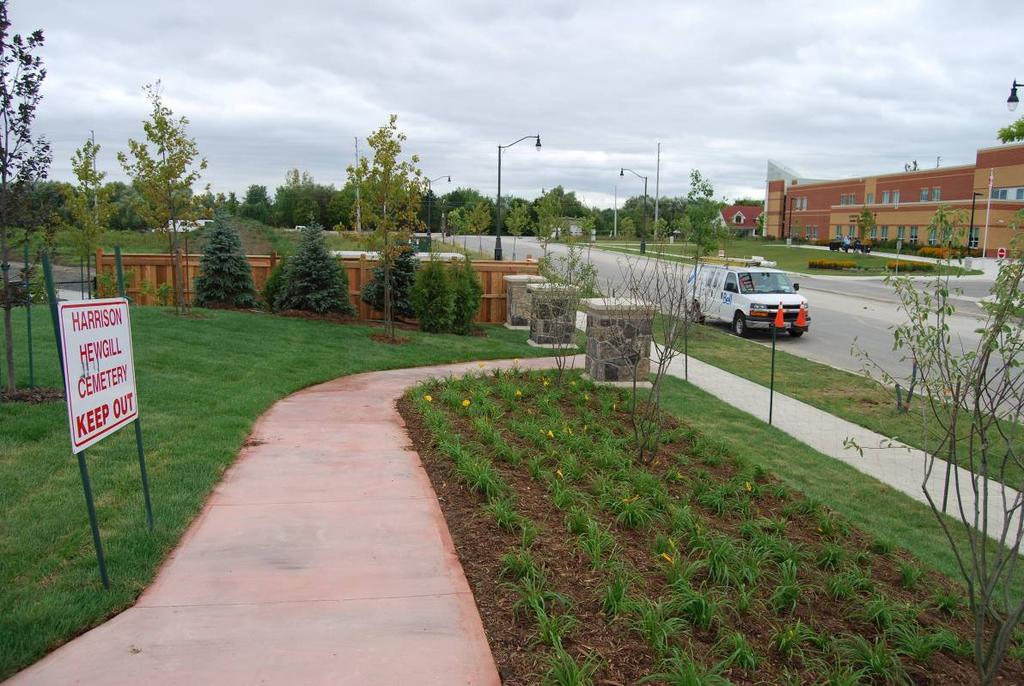
1 L 4-1 HERITAGE REPORT Brampton Heritage Board Date: September 21, 2010 REASONS FOR HERITAGE DESIGNATION Harrison-Hewgill Cemetery The Gore Road at Castle Oaks Crossing August 2010 Jim Leonard Heritage Coordinator Planning, Design & Development Urban Design Section
2 L 4-2 PROFILE OF SUBJECT PROPERTY: ROLL NUMBER PIN NUMBER LT MUNICIPAL ADDRESS The Gore Road / Lot 9 Concession 10 WARD NUMBER 10 LEGAL DESCRIPTION Part of Lots 9 and 10, Concession 10, Northern Division, more particularly described as Block 375, Plan 43M SECONDARY PLAN PROPERTY NAME CURRENT OWNER CRITERIA GRADE CURRENT ZONING Harrison-Hewgill Cemetery City of Brampton A OWNER CONCURRENCE? YES CURRENT USES AND FUNCTIONS cemetery PREVIOUS OWNERS AND OCCUPANTS CONSTRUCTION OR CREATION DATE 1869 RESOURCES ON SUBJECT PROPERTY INCLUDED IN DESIGNATION (circle)
3 L REASONS FOR HERITAGE DESIGNATION: The Harrison-Hewgill Cemetery on The Gore Road is worthy of designation under Part IV of the Ontario Heritage Act for its cultural heritage value or interest. The property meets the criteria for designation prescribed by the Province of Ontario under the three categories of design or physical value, historical value and contextual value. 1.1 STATEMENT EXPLAINING THE CULTURAL HERITAGE VALUE OR INTEREST OF THE PROPERTY The subject property is the site of a small family burial plot, originally a feature within a welltended rural farmstead established in the 1850s by Matthew Harrison and his wife Ann Hewgill-Harrison. The plot was located in a small apple orchard, near the Harrison farmhouse, a brick masonry building in the Ontario Gothic style, dating to about The farmhouse was relocated to McVean Drive in An archaeological assessment of the cemetery completed in 2005 confirmed that the family burial plot consists of a single grave with two interments Ann Hewgill-Harrison and her unnamed infant baby. This share grave burial practices was not unusual under such circumstances. Mother and baby died on July 17, The burials are marked by two beautifully carved stone grave markers embedded, side by side in the soil. The cultural heritage value of the property relates primarily to its historical or associative value. The property is directly associated with the Harrison and Hewgill families both prominent in the Toronto-Gore area. The Matthew Harrison family worked this farm from 1854 to the 1950s. Matthew Harrison (1822-January 5, 1887) was the son of William Harrison and Mary Hutchison. In 1832 William and Mary Harrison and family emigrated to Upper Canada from north Yorkshire, England. They established successful farms in the Wildfield area. On May 20, 1849 Matthew Harrison married Ann Hewgill (August 9, 1829-July 17, 1869). Ann Hewgill was the daughter of William Hewgill and Alice Sleightholme, also from north Yorkshire, England. The Hewgill family emigrated to the new world in William Hewgill became one of the first school teachers in the Toronto-Gore and was the local Wesleyan Methodist minister, affiliated with the Hilltop-Gore Church. Hewgill was also a trustee of the Hilltop-Gore Cemetery. Evidently Matthew Harrison s marriage to Ann Hewgill was met with some resistance from the Hewgill family since Harrison was a Roman Catholic. Animosity existed between many Catholics and Protestants in this period and so called, mixed marriages were not commonplace. Nevertheless the marriage went ahead. The couple established a thriving farm on the subject property, starting in 1854, They built a fine brick masonry farmhouse and had five children together. Sadly, with the birth of their fifth child on July 17, 1869 both mother and infant died.
4 L 4-4 Ann Hewgill Harrison converted to Catholicism in June Family members believe that following her death just one month later husband Matthew wished her to be buried in the St Patrick s Catholic cemetery. Ann s father insisted she be buried in his Methodist Hilltop-Gore Cemetery. It seems that the decision to bury Ann and her baby on the Harrison farm may have been a compromise used to settle the impasse. The cemetery also has the potential to yield information about the many hardships of the early settlers in Peel County who had to endure isolation, a harsh environment and many struggles. From a social historical perspective the site is also a reminder of just how prevalent infant mortality was in the European settlement period. The two white marble grave markers exhibit design value. They are representative of the stone carvers art. The markers display the highly evocative weeping willow motif, a popular Victorian symbol of loss and grief. Both stones have undergone conservation treatments. The cultural heritage value of the property is also connected to its contextual value. It helps define and identify the location of the former Harrison farm. This burial site is the only remaining tangible vestige of the former farmstead. It is physically and historically linked to the farmstead as well as the former cross-roads hamlet of Castlemore (located just north of the subject property at the intersection of The Gore Road and Castlemore Road). The Cemetery also retains a simple, pastoral, rural character. The setting, trees, shrubs and other new landscaping elements introduced in 2010 form an interesting rural green space within an newly urbanized setting. Originally an old apple tree helped define the site but it suffered from years of decay and had to be removed in The statement explaining the cultural heritage value or interest of the subject property, including a description of the heritage attributes of the property along with all other components of the Heritage Report: Statement of Reasons for Heritage Designation, constitute the "reason for heritage designation" required under the Ontario Heritage Act. 1.2 DESCRIPTION OF THE HERITAGE ATTRIBUTES OF THE PROPERTY: Unless otherwise indicated, the reason for designation apply generally to all burials, the grounds generally including all landscaping elements, hedgerows, groupings of trees, and shrubs, vistas, fences and all other natural and structural elements found on the subject property. Specific heritage attributes of significance include: Design / Physical Value: Representative example of a rural Euro-Canadian family burial plot; two marble grave markers.
5 L 4-5 Historical / Associative Value: has the potential to yield information about the many hardships of the early settlers in Peel County who had to endure isolation, a harsh environment and many struggles. from a social historical perspective the site is also a reminder of just how prevalent infant mortality was in the European settlement period. associative value reflecting the history of the former 'cross-roads' hamlet of Castlemore; Contextual Value: all trees bushes, grasses, all groundcovers such as daylilies and all hedgerows; pastoral, rural character of site; physically, functionally, visually and historically linked to its surroundings and to the nearby former hamlet of Castlemore; only remaining physical element of the original Harrison farmstead. 2.0 GENERAL PROPERTY DESCRIPTION: The cemetery is situated on block 375. It is essentially square in shape with the lot line demarked with a decorative wood fence and stone piers. The entrance to the cemetery is from the south side of Castle Oaks Crossing off The Gore Road. The subject property is generally flat in nature. Just to the south of the parcel is a storm water management pond. 3.0 HERITAGE EVALUATION / CRITERIA NOTE: The property meets the criteria for designation prescribed by the Province of Ontario under Ontario Heritage Act Regulation 9/06. The property was listed in the Municipal Register of Cultural Heritage Resources in the 2005 as a "Category A" heritage resource. 4.0 ALTERATION HISTORYAND HERITAGE INTEGRITY NOTE: The original contextual value of the property has been essential lost with the redevelopment of the surrounding lands as a residential subdivision, which is now underway. As part of heritage due diligence an overall heritage conservation management plan was developed in 2005 for the standing heritage features on these lands. Since the very beginning of the process, the development company (Criterion Developments) has been exceptionally cooperative and supportive of the heritage conservation program for these lands. The Harrison farmstead was subject to a heritage impact assessment in 2005.
6 L 4-6 In 2006 a proposal was put forward to relocate the red brick masonry house to an estate lot facing McVean Drive, just south of Mayfield Road. After the completion of additional due diligence (which included a structural assessment and the preparation of measured as is architectural drawings), the plan was endorsed by the Brampton Heritage Board and approved by Council. Relocation was endorsed primarily because of the advanced state of decay exhibited by the house due to several years of being vacant. In the winter of 2005 the Harrison-Hewgill Cemetery suffered damage. Crews working on a Region of Peel road widening along The Gore Road inadvertently dumped fill on a portion of the cemetery site. The City intervened. Work was halted and the fill was removed. Heritage staff called for: a) the preparation of conservation plan; b) an archaeological survey; and c) protective fencing and signage around the perimeter of the cemetery site. The archaeological assessment was completed later in The City then approved a conservation plan. The City applied certain conditions to the approval of the plan of subdivision, including heritage designation of the cemetery and that appropriate street naming opportunities to commemorate the Harrison family be applied. A nearby street has been named Matthew Harrison Street in commemoration of the Harrison farmstead. Originally the cemetery included a very old apple tree presumably original to the Harrison family occupation of the property. In 2009 the tree was evaluated by a professional arborist. It was determined to be in an un-healthy state after years; the result of years of neglect and decay. It was subsequently removed and replaced with a new tree. In December 2009 legal title to the cemetery parcel was conveyed to the City of Brampton. In August 2010 a new landscape plan was implemented for the cemetery. The objective of the plan was to introduce landscaping that is compatible with the historical context of the parcel as a farmstead burial plot. The treatment is intended to be as simple in form as possible, using native perennials, shrubs and tree species, many of which would be typical of a 19 th century pioneer cemetery. Since the historic site is now a City-owned cemetery surrounded by a modern residential subdivision certain new features had to be introduced to ensure public access, on-going maintenance and protection of the site. These features include decorative fencing, signage and vegetation buffers. A storm water management pond was located adjacent to the cemetery to help improve the pastoral and natural character of the cemetery. In August 2010, the two existing marble tombstones were conserved by a professional tombstone restoration company (Sanderson Monuments in Orillia). The stones will be returned to the site and embedded in concrete bases.
7 L NOTE ON ARCHAEOLOGICAL POTENTIAL: The subject property has archaeological significance as a Euro-Canadian cemetery containing two internments in a single grave. 6.0 EXCLUSIONS: There are no exclusions within the proposed scope of heritage designation. 7.0 ACKNOWLEDGEMENTS: Poulton, D.R., Heritage The 2005 Stage 3 Archaeological Test Excavations of the Harrison- Hewgill Cemetery, 9749 The Gore Road (November 2005). Tavendar, George S., From This Year Hence (1984). Harrison, Michael, Harrison Family History and Hewgill Family History (harrisonfamilyhistory.blogspot.com). Lynn Barkey, Criterion Development Corporation.


8 L 4-8 LOCATION MAPS: Harrison Hewgill Cemetery Harrison Hewgill Cemetery

9 Harrison Hewgill Cemetery L 4-9

10 L Peel County Atlas showing the Matthew Harrison farm property on the east side of The Gore Road south of Castlemore. The farmhouse, laneway and apple orchard are depicted.
.")

11 L 4-11 IMAGES: Figures 1 and 2: The Harrison-Hewgill Cemetery (2004) in a neglected condition. The grave stones were marked with crude plastic garden border fences, just visible in the tall grass (see figure 2 below). The rear service wing of the Harrison farmhouse is partially visible in both photos. A drive shed can be seen in figure 2. The farmhouse was located just to the northwest of the graves, across an unpaved laneway. The old apple tree is clearly visible in both photos. Figure 2
 which was located near the cemetery plot. The house faced The Gore Road.")

12 L 4-12 Figures 3 and 4: Photographs showing the front façade of the Harrison farmhouse (ca. 1855) which was located near the cemetery plot. The house faced The Gore Road. It was dismantled in segments, relocated to an estate lot on McVean Drive near Mayfield Road, reconstructed and restored. Figure 4: The cemetery is circled to show its location in context with the farmhouse.
 and the relocated, restored house on")

13 L 4-13 Figures 5 and 6: These comparison photos show the Harrison farmhouse on its original site and setting (figure 5) and the relocated, restored house on McVean Drive (figure 6). Measured architectural drawings made of the house in situ were used to reconstruct and restore the house following relocation. Figure 6

14 L 4-14 Figure 7: Detail shot of the infant marble grave marker in situ as of Figure 8: Ann Hewgill Harrison grave marker, as of It reads: ANN / Wife of Matthew Harrison / Who died / July 17, 1869 / Aged / 40 years.


15 L 4-15 Figure 9: Detail of the grave marker for infant child in the 1980s or 1990s. (Michael Harrison) Figure 10: Photos showing the infant grave marker in situ during the archaeological assessment called for by the City in the summer of The single grave shaft was located but the burials themselves were not disturbed.


16 L 4-16 Figure 11: Archaeological assessment in progress during the summer of A single, undisturbed grave shaft was identified during the survey. Post holes and drainage trenches were also identified (see figure 15). Figure 12: Detail of Ann Hewgill grave marker during archaeological assessment in summer of 2005.


17 L 4-17 Figures 13 and 14: Images of the Harrison Hewgill Cemetery in 2005 following the introduction of site protection measures and the completion of the archaeological assessment. Figure 14
18 L 4-18 Figure 15: Sheet extracted from 2005 archaeological assessment of Harrison Hewgill Cemetery undertaken by D.R. Poulton, showing a plan of the cemetery with grave shaft, markers and other features shown in context.

19 L 4-19 Figures 16 to 21: Assorted images taken of the cemetery within the new residential subdivision plan. Landscaping of the site is underway. Figure 17

20 L 4-20 Figure 18 Figure 19


21 L 4-21 Figure 20 Figure 21: Looking north-west toward Castle Oaks Crossing Road. The grave site is circled. The Harrison House was originally located in the centre of the frame, in approximately the middle of the new road.


22 L 4-22 Figures 22 and 23: Photos documenting the recent restoration of the two original grave markers and their re-installation at the Harrison Hewgill Cemetery.
L 2-1 HERITAGE REPORT: REASONS FOR HERITAGE DESIGNATION. Cheyne Family Cemetery. Main Street South
 L 2-1 HERITAGE REPORT: REASONS FOR HERITAGE DESIGNATION Cheyne Family Cemetery Main Street South October 2013 L 2-2 PROFILE OF SUBJECT PROPERTY: Municipal Address Main Street South (Lot 14, Con 1, EHS)
HERITAGE REPORT: REASONS FOR HERITAGE DESIGNATION. 62 Union Street. Prepared By:
 L 3-1 1 Brampton Heritage Board Date: January 18, 2011 HERITAGE REPORT: REASONS FOR HERITAGE DESIGNATION 62 Union Street Prepared By: Prepared by: Antonietta Minichillo, Heritage Coordinator Planning,
L 4-1. Heritage Report: Reasons for Heritage Designation. Kodors House. 35 Rosedale Avenue West
 L 4-1 Brampton Heritage Board Date: January 17, 2012 Heritage Report: Reasons for Heritage Designation Kodors House 35 Rosedale Avenue West December 2011 1 L 4-2 Profile of Subject Property Municipal Address
L 3-1. Heritage Report: Reasons for Heritage Designation. Peter Archdekin Farmhouse Mayfield Road
 L 3-1 Heritage Report: Reasons for Heritage Designation Peter Archdekin Farmhouse 4585 Mayfield Road December 2011 1 L 3-2 Profile of Subject Property Municipal Address 4585 Mayfield Road PIN Number 142250084
HERITAGE REPORT: REASONS FOR HERITAGE DESIGNATION
 HERITAGE REPORT: REASONS FOR HERITAGE DESIGNATION St. Patrick's Roman Catholic Church and Cemetery in the Hamlet of Wildfield, 11873 The Gore Road BRAMPTON HERITAGE BCARD 0 B R A M P T 0 N Prepared By:
L 1-1. Reason. ns for Heritage Designa
 L 1-1 Herita age Repo ort: Reason ns for Heritage Designa ation Brampton Heritage Board Date: April 15, 2014 10300 Th he Gore Road Former Castlemore Sch hool S.S. No. 6 Ap pril 2014 4 L 1-2 Profile of
HERITAGE REPORT: REASONS FOR HERITAGE DESIGNATION. 37 Church Street East. Prepared By:
 L 1-1 1 Brampton Heritage Board Date: February 15, 2011 HERITAGE REPORT: REASONS FOR HERITAGE DESIGNATION 37 Church Street East Prepared By: Prepared by: Antonietta Minichillo, Heritage Coordinator Planning,
L 3-1. Heritage Report: Reasons for Heritage Designation. Wiley Bridge Gorewood Drive, Claireville Conservation Area
 L 3-1 Brampton Heritage Board Date: June 19, 2012 Heritage Report: Reasons for Heritage Designation Wiley Bridge Gorewood Drive, Claireville Conservation Area June 2012 1 L 3-2 Profile of Subject Property
43: 2165 Dundas St. West, Smith-Carrique Barn and Shed
 1. Description of Property Municipal Address Name (if applicable) Legal Description Location of Property Ownership Access Current Use Existing Designation General Description Priority Level 43: 2165 Dundas
APPENDIX F CULTURAL HERITAGE RESOURCE ASSESSMENT
 APPENDIX F CULTURAL HERITAGE RESOURCE ASSESSMENT TO Katherine Jim, MRC DATE February 28, 2013 (Revised March 6 2013, May 27 2013, June 24 2013) FROM Lindsay Popert, ASI ASI FILE 12EA-084 RE Dundas Street
NATIONAL REGISTER OF HISTORIC PLACES MULTIPLE PROPERTY DOCUMENTATION FORM CONTINUATION SHEET ASSOCIATED PROPERTY TYPES
 Section F, Page 1 ASSOCIATED PROPERTY TYPES Six common property types are identified with the 48 cemeteries surveyed in the Town of Southampton. These six property types are identified as being associated
TOWN OF AURORA HERITAGE IMPACT ASSESSMENTS AND CONSERVATION PLANS GUIDE
 PLANNING AND DEVELOPMENT SERVICES Development Planning Division Heritage Planning Section Phone: 905-727-3123 ext. 4226 Fax: 905-726-4736 Email: planning@aurora.ca Town of Aurora 100 John West Way, Box
HISTORIC TEXAS CEMETERY REQUEST FOR DESIGNATION
 HISTORIC TEXAS CEMETERY REQUEST FOR DESIGNATION List additional descriptions or information on separate pages, if necessary. IDENTIFYING INFORMATION Primary name: Also known as: County: Type: Single grave
Authority: North York Community Council Item 31.7, as adopted by City of Toronto Council on May 6, 7 and 8, 2014 CITY OF TORONTO. BY-LAW No.
 Authority: North York Community Council Item 31.7, as adopted by City of Toronto Council on May 6, 7 and 8, 2014 CITY OF TORONTO BY-LAW No. 53-2015 To designate the property at 65 Centre Avenue (Alexander
2: Bond Street, I.O.F Orphanage
 1. Description of Property 2: 37-53 Bond Street, I.O.F Orphanage Municipal Address 37-53 Bond Street ame (if applicable) Independent Order of Foresters (I.O.F.) Orphanage Legal Description PT LTS 15 &
1. Description of Property
 1. Description of Property 39: 2483 Burnhamthorpe Rd. West, Schellenberg Stables Municipal Address 2483 Burnhamthorpe Rd. West ame (if applicable) Schellenberg Stables Legal Description PT LT 30, CO 2
9: 204 & 240 Front Street, George Street Parkette & Dingle Park. 1. Description of Property. Name (if applicable) Legal Description
 Legal Description") 1. Description of Property Municipal Address Name (if applicable) Legal Description Location of Property Ownership Access Current Use Existing Designation General Description Priority Level 9: 204 & 240
1. Description of Property Municipal Address Name (if applicable) Legal Description Location of Property Ownership Access Current Use Existing Designation General Description Priority Level 9: 204 & 240
HERITAGE REPORT: REASONS FOR HERITAGE DESIGNATION
 L 3-1 HERITAGE REPORT: REASONS FOR HERITAGE DESIGNATION 249 Main Street North Prepared By: July 2011 1 L 3-2 PROFILE OF SUBJECT PROPERTY: ROLL NUMBER 10-04-0-032-03400-0000 PIN NUMBER 141220152 MUNICIPAL
Toronto and East York Community Council Item TE34.30, as adopted by City of Toronto Council on August 25, 26, 27 and 28, 2014 CITY OF TORONTO
 Authority: Toronto and East York Community Council Item TE34.30, as adopted by City of Toronto Council on August 25, 26, 27 and 28, 2014 CITY OF TORONTO BY-LAW 1393-2017 To designate the property at 481
IS THERE MONEY AVAILABLE FOR WORK IN HISTORIC CEMETERIES? The AHC is not aware of any funding available for cemetery preservation or maintenance.
 ALABAMA HISTORICAL COMMISSION The State Historic Preservation Office Voice: (334)242-3184 Fax: (334)262-1083 www.preserveala.org ALABAMA HISTORIC CEMETERY REGISTER WHAT IS THE ALABAMA HISTORIC CEMETERY
57: 2031 North Service Road West, Hilton Farm
 1. Description of Property Municipal Address Name (if applicable) Legal Description Location of Property Ownership Access Current Use Existing Designation General Description Priority Level 57: 2031 North
2154 Dundas Street West Intention to Designate under Part IV, Section 29 of the Ontario Heritage Act
 STAFF REPORT ACTION REQUIRED 2154 Dundas Street West Intention to Designate under Part IV, Section 29 of the Ontario Heritage Act Date: February 2, 2009 To: From: Toronto Preservation Board Toronto and
1. Description of Property
 1. Description of Property Municipal Address Name (if applicable) Legal Description Location of Property Ownership Access Current Use Existing Designation General Description Priority Level 34: 1141 Burnhamthorpe
52: 2182 Lakeshore Road East, Horizons
 1. Description of Property Municipal Address Name (if applicable) Legal Description Location of Property Ownership Access Current Use Existing Designation General Description Priority Level 52: 2182 Lakeshore
Access was not granted. Photographed from road, September 16 th, 2015 (AB) Current Use
 Current Use") 1. Description of Property 32: 191 Burnhamthorpe Rd. East, McDuffie Farm Municipal Address 191 Burnhamthorpe Rd. East ame (if applicable) McDuffie Farm (also spelled McDuffe) Legal Description PT LT 14,
1. Description of Property 32: 191 Burnhamthorpe Rd. East, McDuffie Farm Municipal Address 191 Burnhamthorpe Rd. East ame (if applicable) McDuffie Farm (also spelled McDuffe) Legal Description PT LT 14,
L 9-1. ons for Heritage Designatiion. brook Farrm Clarkway Drive
 L 9-1 Brampton Heritage Board Date: January 21, 2014 Herita age Repo ort: Reaso ons for Heritage Designatiion Pineb brook Farrm 10955 Clarkway Drive January 2014 4 L 9-2 Profile of Subject Property Municipal
Chapter 6 cultural heritage
 6 Cultural Heritage 6.1 Protecting Vaughan s Cultural Heritage 165 6.1.1 Protecting Vaughan s Cultural Heritage 165 6.1.2 Maintaining a Heritage Inventory 166 6.1.3 Promoting Vaughan s Cultural Heritage
STAGE 1 ARCHAEOLOGICAL ASSESSMENT OF RATHBURN ROAD, FROM DUKE OF YORK BOULEVARD TO SHIPP DRIVE, CITY OF MISSISSAUGA. Submitted to:
 STAGE 1 ARCHAEOLOGICAL ASSESSMENT OF RATHBURN ROAD, FROM DUKE OF YORK BOULEVARD TO SHIPP DRIVE, CITY OF MISSISSAUGA Submitted to: McCormick Rankin Corporation 2655 North Sheridan Way, Suite 280 Mississauga,
CULTURAL HERITAGE RESOURCES POLICIES
 New Official Plan CULTURAL HERITAGE RESOURCES POLICIES Date March 6, 2009 Distributed at: Livable Oakville Committee, March 9, 2009 Planning Services Department March 2009 1 1 Policy Discussion Paper:
Baby Point Heritage Conservation District Study. Kick-off Community Meeting March 27, 2017 Humbercrest United Church
 Baby Point Heritage Conservation District Study Kick-off Community Meeting March 27, 2017 Humbercrest United Church Agenda 7:00 Welcome 7:10 HCD Study Overview and Process 8:00 Interactive Discussion /
Garden District Heritage Conservation District Study
 Garden District Heritage Conservation District Study Community Consultation Meeting September 24 th, 2013 What is a Heritage Conservation District? A defined area of heritage significance and character
CITY OF MIAMI CEMETERY 1800 N.E. 2 AVENUE
 CITY OF MIAMI CEMETERY 1800 N.E. 2 AVENUE Designation Report City of Miami REPORT OF THE CITY OF MIAMI PLANNING DEPARTMENT TO THE HERITAGE CONSERVATION BOARD ON THE POTENTIAL DESIGNATION OF CITY OF MIAMI
Recommended Heritage Designation
 Anthony Roman Centre/Markham Civic Centre Markham s heritage designations have typically been 19 th century buildings ... but more recent buildings also illustrate the historical development of the community
VILLAGE OF BOLTON HERITAGE CONSERVATION DISTRICT PLAN
 Page 1 1. INTRODUCTION AND BACKGROUND 1.1 THE PROJECT VILLAGE OF BOLTON HERITAGE CONSERVATION DISTRICT PLAN TERMS OF REFERENCE The Town of Caledon (Town) is a large, predominantly rural municipality with
Memo. B R A Y H e r i t a g e
 6 1 3. 5 4 2. 3 3 9 3 6 1 3. 5 4 9. 6 2 3 1 c a r l @ b r a y h e r i t a g e. c o m Memo To: Jennifer Murray, Windmill Development Corporation From: Carl Bray, Bray Heritage Date: Monday, June 5, 2017
Purchase Proposal Call for the Former St. Louis School 75 Allen Street East Addendum #3 12-June-2013
 Purchase Proposal Call for the Former St. Louis School 75 Allen Street East Addendum #3 12-June-2013 Closing Time and Date: 3:00 p.m. Local Time on Monday June 17, 2013 At the Monday May 27, 2013 Council
Cultural Landscape Heritage Impact Statement Terms of Reference
 Culture Division Community Services Department City of Mississauga 201City Centre Dr, Suite 202 MISSISSAUGA ON L5B 2T4 www.mississauga.ca Leading today for tomorrow Cultural Landscape Heritage Impact Statement
6: 2417 Fourth Line, Sixteen Hollow, Lion Valley Park
 1. Description of Property 6: 2417 Fourth Line, Sixteen Hollow, Lion Valley Park Municipal Address 2417 Fourth Line ame (if applicable) Sixteen Hollow, Lion Valley Park Legal Description CO 1 SDS PT LOTS
CULTURAL HERITAGE ASSESSMENT REPORT CULTURAL HERITAGE LANDSCAPE & BUILT HERITAGE FEATURES
 CULTURAL HERITAGE ASSESSMENT REPORT CULTURAL HERITAGE LANDSCAPE & BUILT HERITAGE FEATURES DUNTROON QUARRY EXPANSION LOT 25 AND PART LOT 26, CONCESSION 12 & PART LOT 25, CONCESSION 12 CLEARVIEW TOWNSHIP
D4. Cultural Heritage Assessment Report: Built Heritage Resources and Cultural Heritage Landscapes
 D4. Cultural Heritage Assessment Report: Built Heritage Resources and Cultural Heritage Landscapes : Built Heritage Resources and Cultural Heritage Landscapes Lambton County, Ontario Submitted to AECOM
GUIDELINES FOR CULTURAL HERITAGE IMPACT ASSESSMENTS
 GUIDELINES FOR CULTURAL HERITAGE IMPACT ASSESSMENTS Purpose A Cultural Heritage Impact Assessment (CHIA) is a study to identify and evaluate built heritage resources and cultural landscapes in a given
CHAIR AND MEMBERS PLANNING & ENVIRONMENT COMMITTEE MEETING ON MONDAY AUGUST 28, 2017 JOHN M. FLEMING MANAGING DIRECTOR, PLANNING AND CITY PLANNER
 TO: FROM: SUBJECT: CHAIR AND MEMBERS PLANNING & ENVIRONMENT COMMITTEE MEETING ON MONDAY AUGUST 28, 2017 JOHN M. FLEMING MANAGING DIRECTOR, PLANNING AND CITY PLANNER REQUEST FOR DEMOLITION OF HERITAGE LISTED
LYTTELTON GRAVING DOCK PUMPHOUSE (M36/327), CYRUS WILLIAMS QUAY, LYTTELTON: REPORT ON ARCHAEOLOGICAL MONITORING
, CYRUS WILLIAMS QUAY, LYTTELTON: REPORT ON ARCHAEOLOGICAL MONITORING") LYTTELTON GRAVING DOCK PUMPHOUSE (M36/327), CYRUS WILLIAMS QUAY, LYTTELTON: REPORT ON ARCHAEOLOGICAL MONITORING HNZ AUTHORITY 2016/248EQ LUKE TREMLETT AND ANNTHALINA GIBSON UNDERGROUND OVERGROUND ARCHAEOLOGY
LYTTELTON GRAVING DOCK PUMPHOUSE (M36/327), CYRUS WILLIAMS QUAY, LYTTELTON: REPORT ON ARCHAEOLOGICAL MONITORING HNZ AUTHORITY 2016/248EQ LUKE TREMLETT AND ANNTHALINA GIBSON UNDERGROUND OVERGROUND ARCHAEOLOGY
GUIDELINES FOR CULTURAL HERITAGE IMPACT ASSESSMENTS
 GUIDELINES FOR CULTURAL HERITAGE IMPACT ASSESSMENTS Purpose The purpose of undertaking a Cultural Heritage Impact Assessment, which is provided by the applicant, is to identify and evaluate cultural heritage
61: 3437 Trafalgar Rd, Matthew Clements House
 1. Description of Property 61: 3437 Trafalgar Rd, Matthew Clements House Municipal Address 3347 Trafalgar Rd Name (if applicable) Matthew Clements Farm Legal Description PT LT 12, CON 1 TRAFALGAR, NORTH
Architectural Inventory Form
 OAHP1403 Rev. 9/98 COLORADO CULTURAL RESOURCE SURVEY Architectural Inventory Form Official eligibility determination (OAHP use only) Date Initials Determined Eligible- NR Determined Not Eligible- NR Determined
Municipal Inventory of Cultural Heritage Properties - St. Joseph Inventory of Designated and Potential Heritage Properties
 Municipal Inventory of Cultural Heritage Properties - St. Joseph Inventory of Designated and Potential Heritage Properties Municipality of Bluewater, Ontario (Comprised of the former Geographical Townships
Mayfield West Phase 2 Secondary Plan
 Town of Caledon Mayfield West Phase 2 Secondary Plan Built Heritage Resources & Cultural Heritage Landscapes Assessment André Scheinman Heritage Preservation Consultant / ENVision The Hough Group Assignment
Intention to Designate under Part IV, Section 29 of the Ontario Heritage Act 844 Don Mills Road and 1150 Eglinton Avenue East
 STAFF REPORT ACTION REQUIRED Intention to Designate under Part IV, Section 29 of the Ontario Heritage Act 844 Don Mills Road and 1150 Eglinton Avenue East Date: September 7, 2016 To: From: Toronto Preservation
Report to Rapport au: Built Heritage Sub-Committee / Sous-comité du patrimoine bâti December 10, 2015 / 10 décembre and / et
 1 Report to Rapport au: Built Heritage Sub-Committee / Sous-comité du patrimoine bâti December 10, 2015 / 10 décembre 2015 and / et Planning Committee / Comité de l'urbanisme January 26, 2016 / 26 janvier
21: Sovereign Street, Streetscape
 1. Description of Property Municipal Address ame (if applicable) Legal Description Location of Property Ownership Access Current Use Existing Designation General Description Priority Level 21: Sovereign
46: 4022 Fourth Line, Ford-Slacer Farm
 1. Description of Property 46: 4022 Fourth Line, Ford-Slacer Farm Municipal Address 4022 Fourth Line Name (if applicable) Ford-Slacer Farm Legal Description PT LT 21, CON 2 TRAFALGAR, NORTH OF DUNDAS STREET,
Los Angeles Department of City Planning RECOMMENDATION REPORT
 Los Angeles Department of City Planning RECOMMENDATION REPORT CULTURAL HERITAGE COMMISSION HEARING DATE: January 13, 2011 TIME: 10:00 AM PLACE: City Hall, Room 1010 200 N. Spring Street Los Angeles, CA
11.1 INTRODUCTION. The characteristics of these areas are briefly discussed below.
 SECTION 11 : HERITAGE PRECINCTS 11.1 INTRODUCTION This section applies to some areas within the Residential and Business Resource Areas. The significant resource management issues for this section are
National Character Area 70 Melbourne Parklands
 Summary The are a landscape of rolling farmland, parkland and woodland on the northern flanks of the ridge between Burton upon Trent and Swadlincote. The land slopes down to the River Trent, which borders
Demolition of a Designated Heritage Property Roncesvalles Avenue
 REPORT FOR ACTION Demolition of a Designated Heritage Property - 421 Roncesvalles Avenue Date: March 8, 2018 To: Toronto Preservation Board Toronto and East York Community Council From: Acting Chief Planner
RE: Report CDS (Municipal Heritage Committee Minutes May 8, 2018) Randwood Estate
 Randwood Estate") June 4, 2018 Members of the Committee of the Whole Town of Niagara-on-the-Lake 1593 Four Mile Creek Road P.O. Box 100, Virgil, ON L0S 1T0 Dear Lord Mayor Darte and Town Councillors: RE: Report CDS-18-028
June 4, 2018 Members of the Committee of the Whole Town of Niagara-on-the-Lake 1593 Four Mile Creek Road P.O. Box 100, Virgil, ON L0S 1T0 Dear Lord Mayor Darte and Town Councillors: RE: Report CDS-18-028
Architectural Inventory Form
 IMPORTANT NOTICE OAHP1403 Rev. 9/98 COLORADO CULTURAL RESOURCE SURVEY Page 1 This survey form represents a only. All information, particularly determinations of eligibility for the National Register, the
Access not granted, notes and photographs from the street Sept (AB) Current Use
 Current Use") 1. Description of Property 49: 1248-1250 Lakeshore Road East, Grenvilla Lodge Municipal Address 1248-1250 Lakeshore Road East ame (if applicable) Grenvilla Lodge. (Incorrectly spelled in the Heritage Register
1. Description of Property 49: 1248-1250 Lakeshore Road East, Grenvilla Lodge Municipal Address 1248-1250 Lakeshore Road East ame (if applicable) Grenvilla Lodge. (Incorrectly spelled in the Heritage Register
Settlement Boundaries Methodology North Northumberland Coast Neighbourhood Plan (August 2016)
") Introduction This background paper sets out a methodology for the definition of settlement boundaries in the North Northumberland Coast Neighbourhood Plan. The neighbourhood plan is planning positively
Introduction This background paper sets out a methodology for the definition of settlement boundaries in the North Northumberland Coast Neighbourhood Plan. The neighbourhood plan is planning positively
PROJECT INFORMATION. The type of development
 A LETTER OF RECOMMENDATION (WITH CONDITIONS) FOR THE EXEMPTION OF A FULL PHASE 1 ARCHAEOLOGICAL HERITAGE IMPACT ASSESSMENT FOR THE PROPOSED, CONSTRUCTION OF A FILLING STATION AND ASSOCIATED INFRASTRUCTURE
1. Description of Property
 1. Description of Property Municipal Address Name (if applicable) Legal Description Location of Property Ownership Access Current Use Existing Designation General Description Priority Level 13: 258 Lakeshore
10. SOUTH ALBION FARMSTEADS
 10. SOUTH ALBION FARMSTEADS 10.1 HISTORICAL CONTEXT This Candidate area is an organically evolved rural landscape, as described in the Town of Caledon: Criteria for the Identification of Cultural Heritage
ONTARIO MUNICIPAL BOARD
 PL 120483 ONTARIO MUNICIPAL BOARD Applicant/Appellant: 2124123 Ontario Limited Subject: OPA, Rezoning and Draft Plan of Subdivision Municipal Address: 3940 Highway 7 East Municipality: City of Markham
Cultural Heritage Landscape Heritage Impact Statement Terms of Reference
 Community Services Department City of Mississauga 201City Centre Dr, Suite 900 MISSISSAUGA ON L5B 2T4 www.mississauga.ca Leading today for tomorrow Cultural Heritage Landscape Heritage Impact Statement
Guidelines for the Protection and Enhancement of the Heritage Character and Vista of King George Highway
 Guidelines for the Protection and Enhancement of the Heritage Character and Vista of King George Highway Surrey Heritage Register Site 214 Approved by Council on March 22, 2004. These guidelines are to
Chain Bridge Road Sidewalk Improvements Citizen Council Work Session
 Chain Bridge Road Sidewalk Improvements Citizen Council Work Session May 10, 2016 Project Location 2 Project Objectives Provide a continuous pedestrian facility (sidewalk) connection from Downtown City
Village of Glenview Plan Commission
 Village of Glenview Plan Commission STAFF REPORT January 22, 2019 TO: Chairman and Plan Commissioners CASE #: P2018-047 FROM: Community Development Department CASE MANAGER: Tony Repp, Senior Planner SUBJECT:
TOWN OF AURORA ARCHITECTURAL SALVAGE PROGRAM GUIDE
 PLANNING AND DEVELOPMENT SERVICES Development Planning Division Heritage Planning Section Phone: 905-727-3123 ext. 4226 Fax: 905-726-4736 Email: planning@aurora.ca Town of Aurora 100 John West Way, Box
I 1-1 HERITAGE IMPACT ASSESSMENT. OSTRANDER FARM 2378 EMBLETON ROAD Lots 5 and 6, Concession 5 WHS CITY OF BRAMPTON, ONTARIO.
 I 1-1 HERITAGE IMPACT ASSESSMENT Ostrander Farm House 2001 Ostrander Farm House Site, May, 2010 Source: Unterman McPhail OSTRANDER FARM 2378 EMBLETON ROAD Lots 5 and 6, Concession 5 WHS CITY OF BRAMPTON,
Analysis of Environs of 1000 New York Street, German Methodist Episcopal Church
 Item No. 3: L-14-00028 p.1 Analysis of Environs of New York Street, German Methodist Episcopal Church Step One Historical Significance and Context According to the application for Historic Landmark Designation,
Cultural Heritage Landscapes Strategy
 Cultural Heritage Landscapes Strategy TABLE OF CONTENTS Executive Summary 1.0 Introduction 1.1 Objectives of the Strategy 2.0 Definition and Identification of Cultural Heritage Landscapes 2.1 Definitions
HERITAGE STATEMENT AND IMPACT ASSESSMENT HILLBARK FARMHOUSE FRANKBY
 HILLBARK FARMHOUSE HERITAGE STATEMENT AND IMPACT ASSESSMENT HILLBARK FARMHOUSE FRONT ENTRANCE CONTENTS Executive summary 1.0 INTRODUCTION 1.1. Background to the report 1.2. Purpose of the Report 2.0 SIGNIFICANCE
SUE ROSEN ASSOCIATES. Re: DA DA/485/2016. Thank you etc
 Re: DA DA/485/2016 Thank you etc I m an Epping based heritage consultant commissioned by the Epping Civic Trust to comment on the heritage aspects of the proposed development and on the reportage associated
2.2.1 Scope of Preliminary Cultural Heritage Landscape Inventory
 Cultural Heritage Landscape and Policy Study Page 7 2.0 CULTURAL HERITAGE LANDSCAPE INVENTORY 2.1 Introduction As part of the City of Vaughan s Official Plan review and associated development of cultural
CHAIR AND MEMBERS PLANNING AND ENVIRONMENT COMMITTEE ON TUESDAY MARCH 29, 2016
 TO: FROM: SUBJECT: CHAIR AND MEMBERS PLANNING AND ENVIRONMENT COMMITTEE ON TUESDAY MARCH 29, 2016 JOHN M. FLEMING MANAGING DIRECTOR, PLANNING AND CITY PLANNER DESIGNATION OF 864-872 DUNDAS STREET UNDER
APPENDIX 1: SCOPED ENVIRONMENTAL IMPACT STATEMENT (EIS) FORM
 FORM") APPENDIX 1: SCOPED ENVIRONMENTAL IMPACT STATEMENT (EIS) FORM This form is intended for use by applicants (primarily private landowners) who need to conduct a Scoped EIS in support of minor development
APPENDIX 1: SCOPED ENVIRONMENTAL IMPACT STATEMENT (EIS) FORM This form is intended for use by applicants (primarily private landowners) who need to conduct a Scoped EIS in support of minor development
City of Kingston Heritage Commemoration Program Guidelines: 7 May 2010
 MHC-13-010 Exhibit B City of Kingston Heritage Commemoration Program Guidelines: 7 May 2010 These guidelines cover three separate types of city heritage commemoration: small markers on designated property.
In Search of the Wyatt Chapel Cemetery Boundaries. Rice University Visiting Graduate Students Bill Baker Jared Sallee July 2010
 In Search of the Wyatt Chapel Cemetery Boundaries Rice University Visiting Graduate Students Bill Baker Jared Sallee July 2010 Review of Aerial Photographs - 2006 Review of Aerial Photographs - 1956 Review
Planning Justification Brief
 Planning Justification Brief Proposed Re-Zoning Halton Catholic District School Board 302, 312, 324, 332 Rebecca Street Lots 4, 5, 6, & 7 and Blocks A & B Registered Plan 552 May 2017 Introduction Strategy
Historic Resources Inventory Evaluation Form
 Evaluation Date September 12, 2017 Historic Resources Inventory Evaluation Form Community District Designation Downtown Grade 1 The place should be rated for each of the criteria below, in order to establish
a) buildings, structures and artifacts of historical significance;
 buildings, structures and artifacts of historical significance;") 12.3.2. Definition Heritage Resources: There are two classes of heritage resources: monumental or landmark heritage that is considered to reflect exemplary architecture and style of a particular area or
12.3.2. Definition Heritage Resources: There are two classes of heritage resources: monumental or landmark heritage that is considered to reflect exemplary architecture and style of a particular area or
section five BEAUTIFICATION PLAN
 section five BEAUTIFICATION PLAN BEAUTIFICATION PLAN Section Five Beautification Plan The goal of the Beautification Plan is to improve the Route 8-Sunnyland Corridor in terms of aesthetics and to create
CLOUGHJORDAN SETTLEMENT PLAN
 CLOUGHJORDAN SETTLEMENT PLAN 1.0 General Introduction and Development Context Location The market town of Cloughjordan lies close to the border with Offaly at the junction of the R490 and R491 Regional
Baker Historic District
 DISTRICT DESCRIPTION This is a historically middle-class neighborhood in the South Side, an area annexed by Denver in 1883, consisting of more than 20 tightly interwoven residential subdivisions. The earliest
THE CITY OF LAKE FOREST HISTORIC PRESERVATION COMMISSION LOCAL LANDMARK NOMINATION INSTRUCTIONS
 THE CITY OF LAKE FOREST HISTORIC PRESERVATION COMMISSION LOCAL LANDMARK NOMINATION INSTRUCTIONS This application is for the nomination of individual properties as Local Historic Landmarks within the City
Cultural Heritage Resource Assessment Review Update of the Mayfield West Phase II Secondary Plan TOWN OF CALEDON, ONTARIO.
 TOWN OF CALEDON, ONTARIO Prepared for: Town of Caledon 6311 Old Church Road Caledon, ON L7C IJ6 File: 17CH-030 May 2017 Archaeological & Providing Cultural Heritage Services 528 Bathurst Street Toronto,
Heritage Property 70 Liberty Street (Central Prison Chapel)
") STAFF REPORT ACTION REQUIRED Alteration of a Designated Heritage Property 70 East Liberty Street (Central Prison Chapel) Date: October 9, 2012 To: Toronto Preservation Board Toronto East York Community
STAFF REPORT ACTION REQUIRED Alteration of a Designated Heritage Property 70 East Liberty Street (Central Prison Chapel) Date: October 9, 2012 To: Toronto Preservation Board Toronto East York Community
Cultural Heritage Resources
 Cultural Heritage Resources An Information Bulletin for Projects Subject to Ontario Regulation 359/09 - Renewable Energy Approvals Ministry of Tourism, Culture and Sport 2011 (updated August 2013) Disclaimer:
Part A. District Overview. Thornhill-Markham Heritage Conservation District Plan 1
 Part A District Overview Thornhill-Markham Heritage Conservation District Plan 1 Thornhill-Markham Heritage Conservation District Plan 2 1.0 Introduction 1.1 The Heritage Conservation District Concept
Heritage Oshawa Meeting
 Heritage Oshawa Meeting Thursday, April 25, 2019 Committee Meeting Room, Council Building Civic Administration Complex Notice to Correspondents: 6:30 p.m. Agenda The personal information contained in your
URBAN DESIGN BRIEF. 2136&2148 Trafalgar Road. Town of Oakville
 URBAN DESIGN BRIEF 2136&2148 Trafalgar Road Town of Oakville Prepared By: METROPOLITAN CONSULTING INC For 2500674 Ontario Inc November 2016 TABLE OF CONTENTS Page No. 1.0 Introduction/Description of Subject
The Maryland-National Capital Park and Planning Commission Prince George's County Planning Department Development Review Division
 The Maryland-National Capital Park and Planning Commission Prince George's County Planning Department Development Review Division 301-952-3530 Note: Staff reports can be accessed at www.mncppc.org/pgco/planning/plan.htm.
BORRISOKANE SETTLEMENT PLAN
 BORRISOKANE SETTLEMENT PLAN 1.0 General Introduction and Development Context Location Borrisokane is located 15km north of Nenagh on the N52. While the town is primarily residential, it acts as a market
Ordnance Street 110 Plan OS Lot 413 B202; parts of Lot 412 and portion of Lot 413
 Ordnance Street 110 Plan OS Lot 413 B202; parts of Lot 412 and portion of Lot 413 110 Ordnance Street has cultural heritage value under 3 categories Physical built in 1886, it is an example of late 19
PLANNING JUSTIFICATION REPORT
 PLANNING JUSTIFICATION REPORT PREPARED FOR: CAMBRIDGE HINDU SOCIETY BOXWOOD DRIVE, CHERRY BLOSSOM AND ROYAL OAK ROAD, CAMBRIDGE PREPARED BY: HANS MADAN, MPA, MCIP, RPP 330 F TRILLIUM DRIVE KITCHENER, ONTARIO
Ontario Municipal Board Commission des affaires municipales de l'ontario
 PL150128 Ontario Municipal Board Commission des affaires municipales de l'ontario PROCEEDING COMMENCED UNDER subsection 34(11) of the Planning Act, R.S.O. 1990, c. P. 13, as amended Applicant and Appellant:
HISTORIC SITE AND MONUMENT COMMISSION (HSMC) Instructions for Historical Markers, Monuments, and Public Art Application
 Instructions for Historical Markers, Monuments, and Public Art Application") HISTORIC SITE AND MONUMENT COMMISSION (HSMC) Instructions for Historical Markers, Monuments, and Public Art Application This document is for information purposes only and does not need to be submitted
HISTORIC SITE AND MONUMENT COMMISSION (HSMC) Instructions for Historical Markers, Monuments, and Public Art Application This document is for information purposes only and does not need to be submitted
Adversely impact the cultural heritage value of properties designated under Part IV of the Ontario Heritage Act (OHA).
.") Cultural Heritage Impact Assessment Rezoning of 180 Metcalfe Street, Ottawa A. Introduction: Robertson Martin Architects (The Consultant) was retained in March 2014 by Roderick Lahey Architect Inc. (the
Cultural Heritage Impact Assessment Rezoning of 180 Metcalfe Street, Ottawa A. Introduction: Robertson Martin Architects (The Consultant) was retained in March 2014 by Roderick Lahey Architect Inc. (the
CULTURAL HERITAGE IMPACT ASSESSMENT TERMS OF REFERENCE
 CULTURAL HERITAGE IMPACT ASSESSMENT TERMS OF REFERENCE The Corporation of the Town of Whitby Planning and Development Department 575 Rossland Road East, Whitby Ontario, L1N 2M8 Telephone: 905-430-4306