CITY OF WILDOMAR CITY COUNCIL Agenda Item #2.1 PUBLIC HEARING Meeting Date: May 9, 2018
|
|
|
- Kerry Heath
- 5 years ago
- Views:
Transcription
1 CITY OF WILDOMAR CITY COUNCIL Agenda Item #2.1 PUBLIC HEARING Meeting Date: May 9, 2018 TO: FROM: Mayor and City Council Members Matthew Bassi, Planning Director SUBJECT: Wildomar Crossings Retail Center Project (PA ): STAFF REPORT RECOMMENDATION: The Planning Commission recommends the City Council take the following actions: 1. Adopt a Resolution entitled: RESOLUTION NO. A RESOLUTION OF THE CITY COUNCIL OF THE CITY OF WILDOMAR, CALIFORNIA, ADOPTING AN INITIAL STUDY/MITIGATED NEGATIVE DECLARATION (SCH# ), INCLUDING ADOPTION OF A MITIGATION MONITORING AND REPORTING PROGRAM (MMRP) FOR THE WILDOMAR CROSSINGS RETAIL CENTER (PA NO ) CONSISTING OF A CHANGE OF ZONE FROM R-R (RURAL RESIDENTIAL) TO C-1/C-P (GENERAL COMMERCIAL), A PARCEL MAP (PM NO ) TO SUBDIVIDE A 3.4+ ACRE SITE INTO 4-PARCELS, AND A PLOT PLAN FOR THE DEVELOPMENT OF A 26,204 SQUARE-FOOT RETAIL CENTER LOCATED AT THE NORTHWEST CORNER OF CLINTON KEITH ROAD AND STABLE LANES (APN: & ). 2. Introduce and approve first reading of an Ordinance entitled: ORDINANCE NO. AN ORDINANCE OF THE CITY COUNCIL OF THE CITY OF WILDOMAR, CALIFORNIA, APPROVING A CHANGE OF ZONE (PA NO ) FROM R-R (RURAL RESIDENTIAL) TO C-1/C- P (GENERAL COMMERCIAL), THE WILDOMAR CROSSINGS RETAIL CENTER LOCATED AT THE NORTHWEST CORNER OF CLINTON KEITH ROAD AND STABLE LANES (APN: & ).
2 3. Adopt a Resolution entitled: RESOLUTION NO. A RESOLUTION OF THE CITY COUNCIL OF THE CITY OF WILDOMAR, CALIFORNIA, APPROVING PARCEL MAP NO (PA NO ) TO SUBDIVIDE A 3.4+ ACRE SITE INTO FIVE (5) PARCELS FOR THE WILDOMAR CROSSINGS RETAIL CENTER LOCATED AT THE NORTHWEST CORNER OF CLINTON KEITH ROAD AND STABLE LANES (APN: & ) 4. Adopt a Resolution entitled: RESOLUTION NO. A RESOLUTION OF THE CITY COUNCIL OF THE CITY OF WILDOMAR, CALIFORNIA, APPROVING PLOT PLAN NO , SUBJECT TO CONDITIONS, TO DEVELOP THE WILDOMAR CROSSINGS RETAIL CENTER CONSISTING OF 26,204+ SQUARE-FOOT COMMERCIAL RETAIL USES LOCATED AT THE NORTHWEST CORNER OF CLINTON KEITH ROAD AND STABLE LANES (APN: & ). BACKGROUND: The Planning Commission reviewed the Wildomar Crossings Retail Center project at its April 16, 2018 special meeting. The Applicant provided a presentation regarding the project s history and community outreach efforts. There were 12 public speakers that spoke in favor of and opposed to the project. Staff did receive 2 comment letters prior to the meeting. One letter was from a resident of the North Ranch community (Mr. Tom Boussiacos) concerned about the overcommercialization of Wildomar and maintaining the rural atmosphere. The other letter was from Wittwer/Parking, LLP (attorney s representing the Southwest Regional Council of Carpenters). This was the second letter received in regards to the IS/MND. The current letter cited concerns about the Air Quality/Greenhouse Gases analysis in the MND, and how the proposed retail project should have resulted in an EIR rather than an MND. Both letters are provided in Attachments L and M for Council review. In response to the Wittwer/Parking, LLP, the Applicant s CEQA attorney has prepared an official response which is provided for Council review in Attachment N. Prior to a motion by the Commission, discussion regarding the architectural style of the project was offered by Commissioner Langworthy. Commissioner Langworthy was concerned that the architectural style was not consistent with other retail projects that have been approved over the past few years. Specifically, the design of the four retail buildings did not achieve the desired rural ranch and/or craftsman style design. This concern was echoed by Commissioner Strong. Consequently, there was discussion on whether to continue the project to a future meeting so the Applicant could consider
3 redesigning the architecture to address the Commission s concerns. As there was not majority support for the continuance, the Commission has recommended a new condition for Council consideration to be added to the Plot Plan resolution to address the architectural comments. Thus, Condition No. 79 will read as follows: Prior to issuance of building permits, the Applicant shall process a substantial conformance application for review and approval by the Planning Director to revise the architectural style for the retail project to incorporate more design elements reflective of the rural ranch/craftsman design styles. This new condition has been added to the Plot Plan resolution which is reflected in Attachment D. The Council may adopt this new condition as written, or craft alternative language as needed. Since this issue was important to the Commission and some were willing to continue the project, the Council may want to consider that approval of the substantial conformance application be authorized by the Planning Commission rather than the Planning Director. In addition to this, staff presented a number of revised conditions for Commission consideration. These revised conditions were worked out with the Staff and the Applicant after the original PC agenda was distributed. The Commission supported the revised conditions and has recommended Council approval. They are summarized below: PC Resolution Edits for Parcel Map No : Public Works Condition No. 13 revised to read as follows: Prior to recordation of the final map, the improvement plans for the required public improvements must be prepared and shall be based upon a design profile extending a minimum of approximately 300 feet beyond the project boundaries at a grade and alignment as approved by the City Engineer. Public Works Condition No. 18 revised to read as follows: Project Street Improvement Plans for Clinton Keith Road shall include bike lanes per the City s Grand Avenue Bike Lane Phase I Capital Improvement Project, in coordination with site improvements and to the satisfaction of the City Engineer. Public Works Condition No. 22 to be deleted in its entirety: Prior to recordation of the final map, the Applicant shall design and improve (or secure) parkway improvements to provide pedestrian connectivity from the project site to Renaissance Plaza located on Clinton Keith Road, southwest of the project site. Improvement shall be to the satisfaction of the City Engineer. Public Works Condition No. 26 revised to read as follows: To determine intersection right of way dedication and ultimate street improvement locations, the applicant shall prepare an Alignment Study at the intersection of Stable Lane Road and Clinton Keith Road to the satisfaction of the City Engineer. The alignment study shall consider the design requirements for all project mitigation
4 identified in the Traffic Impact Analysis to include lane geometry and capacities, new traffic signal locations, striping transitions, driveway locations and future medians. Note: Applicant prepared an Alignment Study as part of the entitlement review. The review of final improvement plans shall reference the Alignment Study. Should a deviation occur between the Alignment Study and final improvement plan review, the applicant and the City Engineer shall find a resolution to both parties satisfaction. PC Resolution Edits for Plot Plan No : Section 3, Plot Finding A last paragraph to be re-written as follows: To further create a landscape buffer between the project and residences, staff has proposed a condition (Planning Condition No. 70) that requires the Applicant to pay up to $20, toward the contract cost directly to a licensed Landscape Contractor to be hired by the North Ranch Homeowners Association to provide a landscape buffer on the slope north of the project site by planting a variety of 24"-box and 36"-box trees and a variety of shrubs along the southerly slope of the North Ranch HOA landscape area located between the project sites' north property line and the existing block wall at the top of the HOA slope. Planning Dept. Condition No. 70 to be re-written as follows: Prior to the issuance of the project's first occupancy permit, if the North Ranch Homeowners Association has entered into a contract with a licensed Landscape Contractor for the installation of landscaping on the HOA's property to provide a landscape buffer on the slope north of the project site by planting a variety of 24"-box and 36"-box trees and a variety of shrubs along the southerly slope of the North Ranch HOA landscape area located between the project sites' north property line and the existing block wall at the top of the HOA slope, then the Applicant shall pay up to $20, toward the contract cost directly to the licensed Landscape Contractor prior to the City's issuance of the project's first occupancy permit. If the North Ranch Homeowners Association has not entered into a contract with a licensed Landscape Contractor for this work when the Applicant contacts the City to initiate the process for issuance of the project's first occupancy permit, the City shall give the North Ranch Homeowners Association 30 days written notice to enter into a contract with a licensed Landscape Contractor for this work. If the North Ranch Homeowners Association fails to enter into a contract with a licensed Landscape Contractor for this work within this 30 day period, the City shall issue the project's first occupancy permit and this condition and its obligation for the Applicant to pay up to $20, of the contract cost shall be null and void. Planning Dept. Condition No. 71 to be revised to read as follows: Prior to the issuance of a precise grading permit, the Applicant shall submit two (2) sets of detailed/complete landscape and irrigation construction drawings including on-site and public right-of-way and shall include a fence/wall plan for review and approval by the Planning Department. Said landscape and irrigation plans shall be prepared by a licensed Landscape Architect and shall comply with all requirements of Chapter (Water Efficient Landscapes) of the Wildomar Municipal Code, including any future
5 water conservation measures adopted by the City Council or imposed by the State of California in effect at the time of development, including but not limited to, droughttolerant landscaping and drip irrigation/micro spray irrigation. The landscape plans shall further show the planting plan for the North Ranch HOA landscape area located between the project sites north property line and the existing block wall at the top of the HOA slope. Public Works Condition No. 23 revised to read as follows: Prior to issuance of a grading permit, the applicant shall submit a grading and erosion control plan and on-site landscape/irrigation plans for review and approval by the City Engineer. Public Works Condition No. 37 revised to read as follows: Prior to recordation of the final map, the improvement plans for the required public improvements must be prepared and shall be based upon a design profile extending a minimum of approximately 300 feet beyond the project boundaries at a grade and alignment as approved by the City Engineer. Public Works Condition No. 41 revised to read as follows: Project Street Improvement Plans for Clinton Keith Road shall include bike lanes per the City s Grand Avenue Bike Lane Phase I Capital Improvement Project, in coordination with site improvements and to the satisfaction of the City Engineer. Public Works Condition No. 43 to be deleted in its entirety: Prior to recordation of the final map, the Applicant shall design and improve (or secure) parkway improvements to provide pedestrian connectivity from the project site to Renaissance Plaza located on Clinton Keith Road, southwest of the project site. Improvement shall be to the satisfaction of the City Engineer. Public Works Condition No. 63 revised to read as follows: Prior to the At issuance of building permit, the applicant shall may pay all necessary impact and mitigation fees required. These fees include, but are not limited to, fees associated with Transportation Uniform Mitigation Fee (TUMF), Quimby (parkland inlieu) Fee, and Development Impact Fees. These revised conditions have been added to the Parcel Map and Plot resolutions for Council consideration at the May 9 th meeting. In the end, the Planning Commission voted (Ballard Absent) to adopt PC Resolution No , , (as amended) and (as amended) recommending City Council adoption of the MND/MMRP and approval of the Change of Zone, Parcel Map and Plot Plan for the Wildomar Crossings Retail project. PROJECT DESCRIPTION: The Applicant (Mann Property Company, Inc., Jim Rochelle) is requesting City Council consideration to develop the Wildomar Crossings Retail Center project. The proposed
6 project consists of the following applications for review and consideration by the City Council. 1) Initial Study/Mitigated Negative Declaration: - The project will require the adoption of a Mitigated Negative Declaration (SCH# ) and a Mitigation Monitoring and Reporting Program in accordance with Article 6, Section of CEQA. 2) Change of Zone No : A proposed change of zone from R-R (Rural Residential) to C/1-C-P (General Commercial) for the entire project site to be consistent with the existing General Plan land use designation of Commercial Retail (CR). 3) Parcel Map No : - A proposed commercial parcel map to subdivide the 3.4 acre site (APN: & ) into five (5) parcels to accommodate the Wildomar Crossings Retail Center project, subject to conditions. 4) Plot Plan No : A proposed Plot Plan application to develop a 26,204+ square-foot commercial retail center, including landscaping and on-off-site improvements in accordance with the development standards of the C/1-C/P (General Commercial) zone, subject to conditions. Surrounding Land Uses: The project site encompasses approximately 3.4+ acres and is located at the NWC of Clinton Keith Road and Stable Lanes. The project site is comprised of two (2) legal parcels zoned R-R (Rural Residential) and is currently vacant. The North Ranch single family residential community is located immediately north & northwest of the site, with vacant land to the west and east. The Renaissance Plaza retail center is located southerly of the project site. The table below summarizes the current uses, land use and zoning designations related to the project site and surrounding properties. The vicinity/location map is shown on the following page. Location Subject Property North ADJACENT LAND USE, GENERAL PLAN AND ZONING Current Land Current GP Land Use Current Zoning Use Designation Designation Vacant North Ranch SFR neighborhood Commercial Retail (CR) Medium Density Residential (MDR) South Vacant Commercial Retail (CR) East Vacant Commercial Retail (CR) West North Ranch SFR neighborhood & HOA vacant land Medium Density Residential (MDR) R-R (Rural Residential) R-1 (One Family Dwelling) C-1/C-P (General Commercial) R-R (Rural Residential) & C-1/C-P (General Commercial) R-1 (One Family Dwelling)

7 Vicinity / Location Map

8 PROJECT ANALYSIS: CEQA/Initial Study/Mitigated Negative Declaration: The Planning Department, in a preliminary review of the proposed project, determined that there was substantial evidence that the Wildomar Crossings Retail Center project may have one or more significant effects on the environment. Therefore, in accordance with the California Environmental Quality Act ( CEQA ), Public Resources Code , and the CEQA Guidelines, 14 CCR , the proposed project required the preparation of an Initial Study/Mitigated Negative Declaration (IS/MND). Based on the CEQA analysis, all potential environmental impacts created by the project (i.e., biological resources, cultural resources, geology/soils, hazards/hazardous materials and noise) have been mitigated to a level of non-significance, and each of the 29 mitigation measure from these impact areas have been incorporated into the project conditions matrix (refer to Attachment C & D, Exhibit 1, respectively). Upon completion of the draft IS/MND and in accordance with CEQA Guidelines Section 15072, the Planning Department on January 31, 2018 provided a Notice of Intent (NOI) to the State Clearinghouse, Riverside County Clerk, Press Enterprise, a local newspaper of general circulation, and the City s local distribution list regarding the preparation and public review of the draft Initial Study/Mitigated Negative Declaration for the proposed Wildomar Crossings Retail Center project. In accordance with CEQA Guidelines and 15105, the draft Initial Study/Mitigated Negative Declaration was released for the required for a 30-day public review period commencing on January 31, 2018 and concluding on March 1, 2018, and which the draft IS/MND was provided to the State Clearinghouse, Responsible Agencies, City s Local Distribution list and other interested parties requesting a copy of the IS/MND. In addition as required by the City s Local CEQA Guidelines, the draft Initial Study/Mitigated Negative Declaration was uploaded to the City s Environmental Documents Center webpage during the same 30-day public review period, and a hard copy was made available at the Planning Department for public review. During the 30-day public review period, the City received eight (8) written comment letters (as noted below) commenting on the draft Initial Study/Mitigated Negative Declaration for the proposed Wildomar Crossings Retail Center project.
9 In accordance with the City s Local CEQA Guidelines, the Planning Department has prepared detailed responses to the eight (8) public comment letters, and a copy of the city s responses were provided to each commenter 10 days prior to the April 18, 2018 Planning Commission meeting. In addition, a Mitigation Monitoring and Reporting Program (MMRP) was prepared in accordance with CEQA Guidelines to monitor compliance with the mitigation measures. The City Council has the authority to review the proposed MND/MMRP upon the recommendation from the Planning Commission. Staff s analysis of the findings in support of the adoption of the MND/MMRP is provided in the Findings of Fact section of the staff report. A copy of the draft IS/MND, technical appendices, response to comments and mitigation monitoring & reporting program are provided for Commission consideration in Attachment A, Exhibits 1-4. Change of Zone No : The Applicant has proposed a change of zone on the 3.4 acre property from R-R (Rural Residential) to C-1/C-P (General Commercial). The existing general plan land use designation for the project site is Commercial Retail (CR). The zone change from R-R (Rural Residential) to C-1/C-P (General Commercial) is highly consistent with the CR land use designation in that it encourages the development of neighborhood commercial retail centers that will provide commercial and retail uses to Wildomar residents consistent with the provision of this CR land use designation. Further, the C-1/C-P zone is a more appropriate zoning category for the proposed project in that the existing R-R zone is not consistent with the CR land use designation nor does it provide for the development of neighborhood commercial retail centers. Therefore, the proposed change of zone to C-1/C-P will create consistent zoning with the General Plan for the entire project site. Staff s analysis of the findings in support of the change of zone is provided in the Findings of Fact section of the staff report. The following three (3) exhibits reflect the existing land use designation and the current and proposed zoning designations.

10 Existing General Plan Land Use Designation Exhibit


11 Existing Zoning Designation Exhibit

12 Proposed Change of Zone Exhibit (I-P rezone to M-SC)

13 Parcel Map No Application: The Applicant has proposed a parcel map to subdivide the 3.4 acre site into five (5) parcels to accommodate the future sale of individual lots. This is a common practice for retail centers, and each parcel has been designed to allow one building on each parcel. The Parcel map is subject to the development standards of the C-1/C-P zone in terms of lot area; however, the C-1/C-P zone has no minimum lot size so the four parcels do meet the lot standard. Staff s analysis of the findings in support of the parcel map is provided in the Findings of Fact section of the staff report. The summary table below reflects the breakdown of the proposed lots, and a reduced copy of the parcel map is provided below as well. Lot/Parcel Number Proposed Use Parcel/Lot Size (Ac.) Minimum Standard Meets Code Standards 1 Auto Zone Store 0.64 ac ac. Yes 2 Wendy s Rest ac ac. Yes 3 Multi-Tenant Store 0.74 ac 0.00 ac. Yes 4 Dollar Tree Store 1.02 ac ac. Yes 5 Open Space/Drainage 0.31 ac ac. Yes Parcel Map No Exhibit
14 Plot Plan No Application: In accordance with Section (C-1/C-P) of the Wildomar Municipal Code (WMC), the Wildomar Crossings Retail Center project is a permitted use subject to the approval of a Plot Plan (Section , WMC). The Plot Plan (i.e., development plans package) serves as the permit to develop the proposed 26,204 square-foot retail center with four (4) buildings. The project site is about 3.4 acres+ and includes four separate buildings. The Applicant has identified three users that will occupy buildings 1, 2 and 4. Building 3 is a multi-tenant building and no specific users have been identified as of the writing of this report. As a point of reference, the zoning ordinance does not regulate the type of businesses that may locate in a retail center. As noted in Section of the WMC, the users noted below fall within the general category of commercial and retail uses. Building Number Proposed Tenant User Building Size (s.f.) 1 Auto Zone Store 7,004 s.f. 2 Wendy s Rest. 2,600 s.f. 3 Multi-Tenant Store 6,600 s.f. (up to 4 suites ) 4 Dollar Tree Store 10,000 s.f. Total Building Size 26,204 s.f. Buffering/Noise: With respect to the existing residences located north of the project site, there is a 75-foot separation between the nearest residential structure and Building 3. This area will contain 15 feet of dense on-site landscaping to buffer activity. To create a better landscape buffer between the project and residences, staff has proposed a condition (Planning Condition No. 70) that will require additional landscaping on the slope north of the project site by planting a variety of 24 -box and 36 -box trees and a variety of shrubs along the southerly slope of the North Ranch HOA landscape area located between the project sites north property line and the existing block wall at the top of the HOA slope. Specifically, this condition reads as follows: Prior to the issuance of the project's first occupancy permit, if the North Ranch Homeowners Association has entered into a contract with a licensed Landscape Contractor for the installation of landscaping on the HOA's property to provide a landscape buffer on the slope north of the project site by planting a variety of 24"- box and 36"-box trees and a variety of shrubs along the southerly slope of the North Ranch HOA landscape area located between the project sites' north property line and the existing block wall at the top of the HOA slope, then the Applicant shall pay up to $20, toward the contract cost directly to the licensed Landscape Contractor prior to the City's issuance of the project's first occupancy permit. If the North Ranch Homeowners Association has not entered into a contract with a licensed Landscape Contractor for this work when the Applicant contacts the City to initiate the process for issuance of the project's first occupancy permit, the City
15 shall give the North Ranch Homeowners Association 30 days written notice to enter into a contract with a licensed Landscape Contractor for this work. If the North Ranch Homeowners Association fails to enter into a contract with a licensed Landscape Contractor for this work within this 30 day period, the City shall issue the project's first occupancy permit and this condition and its obligation for the Applicant to pay up to $20, of the contract cost shall be null and void. In addition to the above, all roof mounted equipment is conditioned to be screened, as well as truck deliveries are restricted to the hours of 8 am and 8 pm (Planning Condition No. 64) to help reduce noise. Site Plan/Building Layout: The site plan has been designed to meet the development standards of the C-1/C-P zone in accordance with Section of the WMC. Staff has analyzed the proposed project site plan to ensure compliance with the development standards related to setbacks, building height, and parking. The table on the following page outlines these details and whether each development standard has been met. Development Standards C-1/C-P Zone Development Standards Table Minimum Dev. Standard Proposed Project Meets Requirements Minimum Lot Area No minimum standard 3.4+ acres Yes Building Height 50 feet (maximum) 33 feet (tallest point Bld. #4) Yes Required Setbacks Front Yard Street Setbacks (CKR & Stable Lanes) 0-foot setback distance for buildings less than 35 feet in height. Bld. #1 = 5 along Stable Lanes and 80 along CKR. Bld. #2 = 165 along Stable Lanes) and 50 along CKR. Yes Yes Bld. #3 = 5 along Stable Lanes and 268 along CKR. Yes Bld. #4 = 325 along Stable Lanes and 165 along CKR. Yes Side Yard Setback (west property line) 0-foot setback distance for buildings less than 35 feet in height. Bld. #4 = 13-9 along west property line. Bld. #2 = 155 along west property line. Yes Yes Rear Yard Setback (north property line) 0-foot setback distance for buildings less than 35 feet in height. Bld. #3 = 15-3 along north property line. Bld. #4 = 10-5 along north property line. Yes Yes
16 Off-Street Parking: The proposed retail project must also comply with the parking and landscaping standards outlined in Section and , respectively. The retail project has four buildings ranging in size from 2,600 to 10,000 square feet with a total size of 26,204 square feet. As a neighborhood retail center, the parking code requires 5.5 parking spaces per 1,000 square feet of building use. This means the total required parking for the project is 144 spaces. The site plan shows 145 parking spaces provided, thus, the parking requirement has been met. This amount includes all required handicap/accessible stalls. Each parking stall has also been designed to meet the minimum stall dimensions, including drive aisles and back-up areas. Since the Applicant intends to subdivide the site into 4 parcels, a reciprocal access and parking agreement must be recorded concurrently with the final parcel map. This ensures that visitors and park wherever they want on the site, and that access between the parcels can be achieved (refer to Public Works Condition No. 29 in Attachment C, Exhibit 1). The table on the following page summarizes compliance with the required parking standards. Parking Standards Commercial Retail Buildings (26,204 s.f.) Parking Stall Size (open) Parking/Landscaping Standards Table (17.188) Minimum Parking Requirement Standard 5.5 spaces / 1,000 s.f. = 144 spaces 9 x x 18 (end stalls) Proposed Project Meets/Exceeds Requirements 145 spaces Yes 9 x x 18 (end stalls) On-site Drive Aisles 24 feet feet minimum Yes Open Parking Area Shading Interior Parking Area Landscaping Yes Yes 50% 55% Yes 10% 19% Yes Landscaping/Water Efficient Standards (Chapter ): The Applicant has provided a detailed conceptual landscape plan for staff s review. The purpose of Chapter of the Zoning Ordinance is to establish water efficient landscape regulations that are at least as effective in conserving water as the State Model Water Efficient Landscape Ordinance in the context of conditions in the City in order to ensure that landscapes are planned, designed, installed, maintained, and managed in a manner that uses water efficiently, encourages water conservation, and prevents water waste. The intent of this chapter is to also encourage the cooperation between the City and local water purveyors to achieve irrigation efficiency and water conservation goals. The conceptual landscape plans provide for a variety of landscape species (including drought tolerant turf) in varying sizes to accommodate the project. The landscape plans were reviewed by the City s Landscape Architect in accordance with the provisions of this
17 code section. Based on this review, the conceptual landscape plans are consistent with city standards. During the construction plan check process, staff will perform a detailed landscape and irrigation plan review to determine that the proposed water usage meets the requirements of Chapter Based on the conceptual landscape plans, the project is consistent with city standards. On-Site Vehicular Circulation and Access: The primary vehicular access for visitors and employees will occur from Stable Lanes Road driveway with secondary access (right-in & right-out) being provided on Clinton Keith Road. The site has also been conditioned to construct public improvements along both Stable Lanes and Clinton Keith Road, including most importantly a traffic signal at the intersection of Stable Lanes and Clinton Keith Road. These improvements will provide safe pedestrian and vehicular circulation for the project, including emergency vehicle access. Refer to Public Works conditions 40, 42, 43 & 44 for specific detail on these public improvements (Attachment D, Exhibit 1). Proposed Grading: According to the preliminary grading plan, the project will require approximately 7,900 cubic yards of cut and 11,900 cubic yards of fill material to build the project. This leaves a need for the Applicant to import about 4,000 cubic yards of dirt. While the Applicant could not achieve a balanced site, the amount of import is small. Based on review of the preliminary grading and site design, and the environmental analysis, the proposed grading plan is in compliance with city grading policies. Proposed Architecture: While the city does not have commercial design guidelines, staff worked with the Applicant to achieve an architectural design that is consistent with the design of existing retail centers along the Clinton Keith Corridor. The architectural theme for the commercial retail project can be loosely characterized as a modern Craftsman with design elements such as stucco, wood trellis s, columns, etc. The color scheme is earth tone scheme. Architectural elevation exhibits are provided on the following pages. Conclusion: Based on review of the proposed site plan, grading plan, landscaping plan and architectural elevations, the Planning Department has determined that the Wildomar Crossings Retail Center project does meet and exceed all applicable development standards. The project as proposed is also consistent with the General Plan land use designation of Commercial Retail. Further, all environmental impacts created by the project have been mitigated to a level of non-significance, and each mitigation measure has been incorporated into the project conditions (refer to Attachment C & D, Exhibit 1). Project development plans are provided for City Council review in Attachments F H of the staff report packet. The following exhibits provide a snap-shot illustration of each.

18 Site Plan / Landscape Plan Exhibit

19 Proposed Building Elevation Exhibits
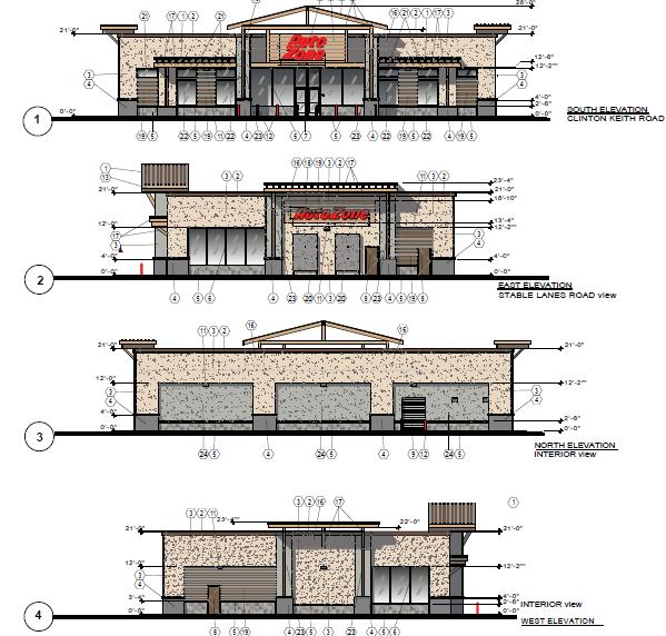
20
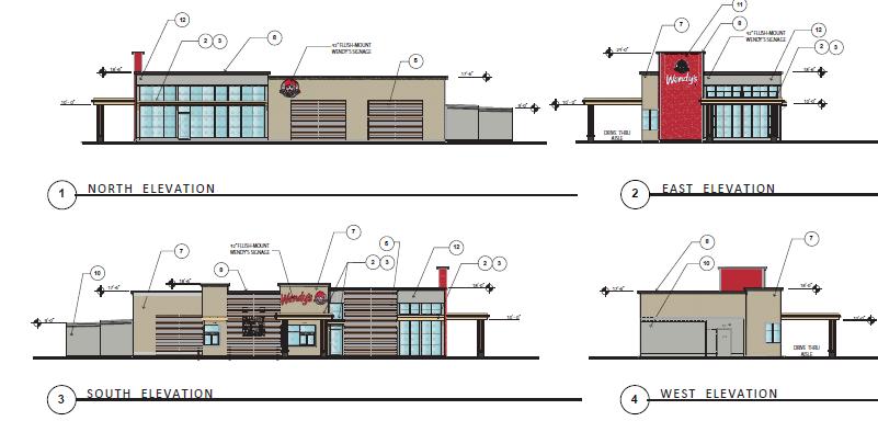
21

22 Building 3 (Multi-Tenant Building
23 AB 52 Compliance - Tribal Consultation: AB 52 requires the lead agency to contact all culturally affiliated tribes that could be affected by a project within 14 days of receiving a development application. The Wildomar Crossings Retail Center project was formally November 29, In accordance with state law, tribal consultation letters were sent to five (5) local Indian tribes (i.e., Agua Caliente, Morongo, Soboba, Pechanga & Rincon) on November 30, Within the prescribed 30-day deadline, the city received two (2) consultation request letters from the Soboba and Pechanga tribes. The city as the lead agency has an additional 30 days to set up consultation meetings with the responding tribes. Staff met via a conference calls with the Soboba tribe on February 1, 2017 and with the Pechanga tribe on February 28, Based on the information presented in the Project Cultural Resources Investigation, the Project would not affect known or probable resources that are listed or eligible for listing in the California Register of Historical Resources; or resources listed in a local register of historical resources as defined in Public Resources Code section (k). The Project Cultural Resources Investigation also substantiates that the Project would not adversely affect known or probable resources determined by the lead agency, in its discretion and supported by substantial evidence, to be significant pursuant to criteria set forth in subdivision (c) of Public Resources Code Section The City has complied with the notification and procedural requirements under AB 52. The AB 52 consultation documentation is provided within the IS/MND (refer to Attachment A, Exhibit 1-4). Based on our AB 52 consultation process, the city and tribes agreed to six (6) cultural mitigation measures to be imposed on the project (refer to Planning conditions 52-57, Attachment D, Exhibit 1). These measures will ensure protection of, as yet unknown cultural resources that may be encountered in developing the project, as well as, protection of tribal cultural resources that may be discovered during the construction phases. Thus, the proposed Wildomar Crossings Retail Center project will not result in any significant impacts to cultural resources and/or tribal cultural resources, thereby, complying with AB 52. AB 52 states that the consultation concludes when either 1) the parties agree to measures to mitigate or avoid a significant effect, if a significant effect exists, on a tribal resource, or 2) a party, acting on good faith and after a reasonable effort, concludes that mutual agreement cannot be reached. Since the city and tribes have agreed to mitigation measures, the AB 52 consultation process was concluded.
24 PROJECT FINDINGS OF FACT: In accordance with state law and city ordinances, the following findings are presented to the City Council, upon recommendation of the Planning Commission, to adopt MND/MMRP, and approve the Change of Zone, Tentative Parcel Map and Plot Plan for the Wildomar Crossings Retail Center project. CEQA/MND Findings: Based on the analysis above and compliance with CEQA Guidelines, the Planning the Planning Commission, in light of the whole record before it, including but not limited to, the draft IS/MND, Technical Appendices, Final MND/Response to Comments, and Mitigation Monitoring and Reporting Program, and all documents incorporated by reference therein, any comments received and responses provided, and other substantial evidence (within the meaning of Public Resources Code 21080(e) and ) within the record and/or provided at the public hearing, recommends the City Council find and determine as follows: A. Review Period: That the City has provided a 30-day public review period for the draft Initial Study/Mitigated Negative Declaration as required by CEQA Guidelines and B. Compliance with Law: That the draft Initial Study/Mitigated Negative Declaration and the Mitigation Monitoring and Reporting Program were prepared, processed, and noticed in accordance with the California Environmental Quality Act (Public Resources Code Section et seq.) and the CEQA Guidelines (14 California Code of Regulations Section et seq.). C. Independent Judgment: That the draft Initial Study/Mitigated Negative Declaration and the Mitigation Monitoring and Reporting Program reflect the independent judgment and analysis of the City. D. Mitigation Monitoring and Reporting Program: That the Mitigation Monitoring and Reporting Program is designed to ensure compliance during project implementation in that changes to the project and/or mitigation measures have been incorporated into the project and are fully enforceable through permit conditions, agreements, or other measures as required by Public Resources Code Section E. No Significant Effect: That revisions made to the project as agreed to by the applicant, and mitigation measures imposed as conditions of approval on the project, avoid or mitigate any potential significant effects on the environment identified in the Initial Study to a point below the threshold of significance. Furthermore, after taking into consideration the revisions to the project and the mitigation measures imposed, the City Council finds that there is no substantial evidence, in light of the whole record, from which it could be fairly argued that the project may have a significant effect on the environment. Therefore, the City Council concludes that the project will not have a significant effect on the environment with adoption of the proposed mitigation measures as outlined in the Mitigation Monitoring and Reporting Program.
25 Change of Zone No Findings: In accordance with Government Code Sections and Chapter of the Wildomar Zoning Ordinance, the Planning Commission, in light of the whole record before it, including but not limited to the Planning Department s staff report and all documents incorporated by reference therein, the City s General Plan and Zoning Ordinance, and any other evidence within the record or provided at the public hearing of this matter, recommends the City Council make the following finding in support of Change of Zone No : A. The proposed change of zone is in conformance with the adopted General Plan for the City of Wildomar. Evidence: The existing general plan land use designation for the project site is Commercial Retail (CR). The zone change from R-R (Rural Residential) to C-1/C-P (General Commercial) is highly consistent with the CR land use designation in that it encourages the development of neighborhood commercial retail centers that will provide commercial and retail uses to Wildomar residents consistent with the provision of this CR land use designation. Further, the C-1/C-P zone is a more appropriate zoning category for the proposed project in that the existing R-R zone is not consistent with the CR land use designation nor does it provide for the development of neighborhood commercial retail centers. Therefore, the proposed change of zone to C-1/C-P will create consistent zoning with the General Plan for the entire project site. Parcel Map No Findings: In accordance with Government Code , and 66474, and Title 16 (Subdivisions) of the Wildomar Municipal Code, the Planning Commission, in light of the whole record before it, including but not limited to the Planning Department s staff report and all documents incorporated by reference therein, the City s General Plan, Subdivision Ordinance, Zoning Ordinance, standards for public streets and facilities, and any other evidence within the record or provided at the public hearing of this matter, recommends the City Council hereby make the following findings in support of Parcel Map No : A. The proposed Parcel map is consistent with the City s General Plan and any applicable specific plan as specified in Government Code Section Evidence: The proposed parcel map (TPM No ) is consistent with the City s General Plan land use designation of Commercial Retail (CR) which has been established since the City s 2008 incorporation, and the proposed C-1/C-P zoning designation, in that the land use and zoning designations are intended to facilitate the development of commercial and retail land uses and businesses. Given its close proximity other retail and surrounding residential neighborhoods, the Wildomar Crossings Retail project will provide additional commercial and retail service opportunities for residents to shop close to home which is also encouraged in the CR land use and C-1/C-P zoning designations. Given these facts, the proposed
26 Parcel Map is consistent with the General Plan. Therefore, the proposed Parcel map meets this finding. In addition to the above discussion, the commercial and retail project also is consistent with the following land use policies: LU 4.1 LU 6.1 The proposed commercial retail project will accommodate a land use development proposal that is located and designed to visually enhance and not degrade the character of the surrounding area. The proposed commercial retail project will be developed in accordance with the CR land use and C-1/C-P zoning designations that are intended to ensure compatibility and minimize impacts. LU 22.1 The proposed commercial retail project will accommodate the development of commercial, retail and restaurant users in an area that is appropriately designated by the General Plan land use designation of Commercial Retail (CR). LU The proposed commercial retail project has been designed in a manner that considers the surrounding area and that visually enhances the semirural character of the community. LU 23.1 The proposed commercial retail project is properly located on property that has had the General Plan land use designation of Commercial Retail (CR) since City incorporation in LU 23.8 The proposed commercial retail project is located in a commercially designated area that will provide additional commercial and retail services, including sales tax and jobs for Wildomar residents. B. The design or improvement of the proposed subdivision is consistent with the City s General Plan and any applicable specific plan. Evidence: The proposed subdivision has been designed to meet all City policies applicable to commercial parcel maps located in the CR land use designation and all development standards of the proposed C-1/C-P zone. The site has also been designed and conditioned to construct public improvements such as street widening, traffic signal, etc., which will provide safe pedestrian and vehicular circulation for the project, including emergency vehicle access. Further, utilities, and drainage facilities have been properly designed in conformance with City standards. Given these facts, the proposed Parcel Map has been designed to be consistent with the City s General Plan. There is no specific plan governing this project. Therefore, the proposed Parcel map meets this finding.
27 C. The site is physically suitable for the type and proposed density of development. Evidence: The project site encompasses approximately 3.4+ acres. The tentative map proposes to subdivide the site into four (4) parcels to accommodate the future sale of these parcels. Each parcel exceeds the minimum lot size for parcels in the C-1/C-P zone (Chapter of the WMC) so this parcel map is physically suitable to accommodate the proposed 26,204 square-foot commercial and retail project. Full ingress and egress has been provided from Stable Lanes, with restricted rightin right-out ingress and egress on Clinton Keith to ensure vehicular safety. Further, the project has been designed to meet all development standards (i.e., setbacks, building height, parking, landscaping, etc.) of the proposed C-1/C-P zone so no variances or exceptions are needed to build the project. Given these facts, the proposed Parcel Map is physically suitable for the type and proposed density of development. Therefore, the proposed Parcel map meets this finding. D. The design of the subdivision or proposed improvements are not likely to cause substantial environmental damage or substantially and avoidably injure fish or wildlife or their habitat. Evidence: The City has prepared an Initial Study for the proposed commercial and retail project, including Parcel Map No , that lead to the preparation of a Mitigated Negative Declaration and Mitigation Monitoring and Reporting Program. The MND for the Wildomar Crossings Retail project, analyzed all the required environmental issues as mandated by CEQA law, including issues related to fish and wildlife and their respective habitats as required in this finding. Specifically, the project was required to prepare a Biological Resources Assessment, Jurisdictional Delineation and a Determination of Biologically Equivalent or Superior (DBESP) to address fish and wildlife habitat on the project site. As part of the environmental review, the City and Applicant coordinated the preparation of these studies with the U.S. Fish and Wildlife and California Fish and Wildlife agencies. Based on their review and coordination, 14 biological mitigation measures were created (and supported by the Wildlife Agencies) for the project to address and mitigate project impacts. These mitigation measures have been added into the required Mitigation Monitoring and Reporting Program (MMRP) and project conditions as required by CEQA (refer to Planning Conditions No. 8 21). Given these facts, it has been determined that the design of the proposed 4-lot parcel map and proposed improvements will not likely cause substantial environmental damage or substantially and avoidably injure fish or wildlife or their habitat project with implementation of the proposed mitigation measures described above. Therefore, the proposed Parcel map meets this finding.
28 E. The design of the subdivision or type of improvements is not likely to cause serious public health problems. Evidence: The design of the subdivision is in conformance with the City s General Plan, Zoning Code and Subdivision Ordinance. The design and construction of all on-site and off-site improvements to accommodate the project have been conditioned to comply with all applicable city ordinances, codes, and standards including, but not limited to, regional water quality and stormwater runoff management requirements and adopted public works standards. As the City s ordinances, codes, and standards have been created based on currently accepted standards and practices for the preservation of the public health, safety and welfare, the proposed Parcel map project meets this finding. F. The design of the subdivision or the type of improvements will not conflict with easements, acquired by the public at large, for access through or use of, property within the proposed subdivision. Evidence: No easements of record or easements established by judgment of a court of competent jurisdiction for public access across the site have been disclosed in a search of the title records for the site and the City does not otherwise have any constructive or actual knowledge of any such easements. Plot Plan No Findings: In accordance with Chapter of the Wildomar Municipal Code (Title 17), the Planning Commission, in light of the whole record before it, including but not limited to the Planning Department s staff report and all documents incorporated by reference herein, the City s General Plan and any other evidence within the record or provided at the public hearing of this matter, recommends the City Council make the following findings in support of Plot Plan No : A. The proposed use is consistent with the Wildomar General Plan and Zoning Ordinance. Evidence: The Applicant is proposing a Plot Plan (in accordance with Section of the Wildomar Municipal Code) to develop a 26,204 square-foot commercial and retail shopping center consisting of the following uses: 1) a 10,000 square-foot Dollar Tree store; 2) a 7,004 square-foot Auto Zone store; 3) a 2,600 square-foot Wendy s drive-through restaurant; and 4) a 6,600 square-foot multi-tenant retail building (users to be determined at a later date). Approval of the Plot Plan must be consistent with the General Plan land use designation of Commercial Retail (CR) and development standards of the C-1/C-P zone (Section of the Wildomar Municipal Code). In evaluating the proposed retail and commercial center, the design of the plot and proposed uses is consistent with the existing CR general plan land use designation in that this land use designation specifically encourages the development of
29 neighborhood commercial and retail centers. With its close proximity to residential neighborhoods in the area, the Wildomar Crossings Retail project will provide commercial and retail services to meet the needs of city residents and provide jobs and sales tax revenue. Given that the C-1/C-P zone is highly consistent with the CR land use designation, the proposed project is consistent with the General Plan as required by this finding. In addition, the proposed use also is consistent with the following General Plan policies: LU 4.1 LU 6.1 The proposed commercial and retail project will accommodate a land use development proposal that is located and designed to visually enhance and not degrade the character of the surrounding area. The proposed commercial and retail project has been developed in accordance with the proposed General Plan land use designation of CR which ensures land use consistency. LU 22.1 The commercial and retail project will accommodate the development of commercial and retail uses on a site that is appropriately designated by the General Plan for these type of uses. LU The proposed commercial and retail project is designed to consider the surrounding areas to visually enhance the appearance and character of the area. LU 23.1 The proposed commercial and retail project is properly located and designated for commercial development in accordance with the General Plan land use category of CR. LU 23.8 The commercial and retail project is located in a commercially designated area that will provide neighborhood services, jobs and sales tax revenues for the City in accordance with the General Plan. Further, the proposed plot plan has been evaluated in detail to ensure the site is developed in compliance with the development standards of the proposed C-1/C-P zone. Based upon a detailed review of the development plans, all development standards outlined in the C-1/C-P zone related to setbacks, building height, etc., have been met and/or exceeded (refer to the development standards summary table of the staff report for additional detail). Further, the design and layout of the project, meets and exceeds the parking, signage and landscaping standards outlined in Section , and of the Zoning Ordinance (refer to the development standards summary table of the staff report for additional detail). With respect to the existing residences located north of the project site, there is a 75-foot separation between the nearest residential structure and Building 3. This area will contain 15 feet of dense on-site landscaping to buffer activity. To further create a landscape buffer between the project and residences, staff has proposed a
Planning Commission Staff Report June 5, 2008
 Owner/Applicant Taylor Village Sacramento Investments Partners, LP c/o Kim Whitney 1792 Tribute Road #270 Sacramento, CA 95815 Staff Recommendation Planning Commission Staff Report Project: File: Request:
Prepared by: Casey Kempenaar, Senior Planner
 CITY OF CITRUS HEIGHTS PLANNING DIVISION STAFF REPORT PLANNING COMMISSION MEETING September 13, 2017 Prepared by: Casey Kempenaar, Senior Planner REQUEST The applicant requests a Design Review Permit Modification
Glenborough at Easton Land Use Master Plan
 Implementation 114 9.0 IMPLEMENTATION 9.1 OVERVIEW This chapter summarizes the administrative procedures necessary to implement the proposed land use plan, infrastructure improvements, development standards,
STAFF REPORT TO THE CITY COUNCIL. Conduct Public Hearing to vacate certain public right of way adjacent to Sycamore Avenue and San Pablo Avenue
 STAFF REPORT TO THE CITY COUNCIL DATE: Adjourned Regular Meeting of December 16, 2014 TO: SUBMITTED BY: SUBJECT: Mayor and Members of the City Council Holly Smyth, Planning Director Conduct Public Hearing
Planning Commission Staff Report February 5, 2015
 Planning Commission Staff Report Project: 99 Cents Only Store File: EG-14-018 Request: General Plan Amendment, Rezone, and Design Review Location: 8945 Brown Road; northeast corner of Elk Grove-Florin
SPECIFIC PLAN Requirements
 CITY OF LANCASTER PLANNING DEPARTMENT 44933 Fern Avenue, Lancaster, California 93534 (661) 723-6100 SPECIFIC PLAN Requirements Purpose The purpose of a specific plan is to provide for the logical development
PLANNING COMMISSION. Submitted
 PLANNING COMMISSION City Hall 1275 Main Street El Centro, CA 92243 Submitted PLANNING COMMISSION ACTION ITEM (1844) Meeting: 05/10/16 12:00 AM Department: Community Development Category: Public Hearing
Report to City Council
 Attachment 4 BUDGET OFFICER CITY ATTORNEY APPROVALS CITY MANAGER Report to City Council TO: FROM: Mayor and City Council John C. Terell, Community and Economic Development Director AGENDA DATE: June 24,
PC RESOLUTION NO
 PC RESOLUTION NO. 14-01-14-02 TENTATIVE TRACT MAP fttm) 17441. REZONE {RZ) 13-003, ARCHITECTURAL CONTROL (AC) 13-003, TREE REMOVAL PERMIT (TRP) 13-052. GRADING PLAN MODIFICATION (GPM) 13-002. CONDITIONAL
ORDINANCE NO
 ATTACHMENT CC-1 ORDINANCE NO. 13-2113 AN ORDINANCE OF THE CUPERTINO CITY COUNCIL APPROVING THE REZONING OF AN APPROXIMATELY 1.1 ACRE AREA FROM PARK AND RECREATION (PR) TO PLANNED INDUSTRIAL PARK (P(MP))
MEMORANDUM. TERESA McCLISH, COMMUNITY DEVELOPMENT DIRECTOR
 MEMORANDUM TO: FROM: BY: CITY COUNCIL TERESA McCLISH, COMMUNITY DEVELOPMENT DIRECTOR KELLY HEFFERNON, ASSOCIATE PLANNER SUBJECT: CONSIDERATION OF ADOPTION OF AN ORDINANCE AMENDING CHAPTER 16.84 OF THE
Approved: CITY OF ARDEN HILLS, MINNESOTA PLANNING COMMISSION WEDNESDAY, AUGUST 5, :30 P.M. - ARDEN HILLS CITY HALL
 Approved: CITY OF ARDEN HILLS, MINNESOTA PLANNING COMMISSION WEDNESDAY, AUGUST 5, 2015 6:30 P.M. - ARDEN HILLS CITY HALL PLANNING CASES A. Planning Case 15-016; Final Planned Unit Development Arden Plaza;
PLANNING REPORT CITY OF EAGAN. APPLICANT: Cedar Grove Hospitality, LLC HEARING DATE: December 18, 2014
 PLANNING REPORT CITY OF EAGAN REPORT DATE: December 8, 2014 CASE: 19-PA-11-11-14 APPLICANT: Cedar Grove Hospitality, LLC HEARING DATE: PROPERTY OWNER: The Flats at Cedar APPLICATION DATE: Nov. 21, 2014
12 January 12, 2011 Public Hearing APPLICANT: TAILWIND DEVELOPMENT GROUP,LLC PROPERTY OWNER: CITY OF VIRGINIA BEACH
 12 January 12, 2011 Public Hearing APPLICANT: TAILWIND DEVELOPMENT GROUP,LLC PROPERTY OWNER: CITY OF VIRGINIA BEACH STAFF PLANNER: Faith Christie REQUEST: Conditional Change of Zoning (from PD-H1 Planned
Project phasing plan (if applicable) 12 copies of site plan
 12 copies of site plan") SITE PLAN REVIEW PERMIT APPLICATION City of Grand Haven, 11 N. Sixth Street, Grand Haven, MI 49417 Phone: (616) 847-3490 Fax: (616) 844-2051 Website: www.grandhaven.org 1. Project Information Address/location
SITE PLAN REVIEW PERMIT APPLICATION City of Grand Haven, 11 N. Sixth Street, Grand Haven, MI 49417 Phone: (616) 847-3490 Fax: (616) 844-2051 Website: www.grandhaven.org 1. Project Information Address/location
Staff Report and Recommendation
 Community Planning and Development Planning Services 201 W. Colfax Ave., Dept. 205 Denver, CO 80202 p: 720.865.2915 f: 720.865.3052 www.denvergov.org/cpd TO: City Council Neighborhoods and Planning Committee
Attachment 4. TRPA Environmental Documentation, IEC/MFONSE
 Required Findings for Certification of the Final Initial Study/Mitigated Negative Declaration (IS/MND) and Initial Environmental Checklist/Mitigated Finding Of No Significant Effect (IS/MFONSE) TRPA Environmental
AWH REPORT OF THE PLANNING AND DEVELOPMENT DEPARTMENT FOR APPLICATION FOR REZONING ORDINANCE TO PLANNED UNIT DEVELOPMENT
 AWH REPORT OF THE PLANNING AND DEVELOPMENT DEPARTMENT FOR APPLICATION FOR REZONING ORDINANCE TO PLANNED UNIT DEVELOPMENT MAY 8, 2014 The Planning and Development Department hereby forwards to the Planning
ORDINANCE NO. 430 REGARDING WATER CONSERVATION
 ORDINANCE NO. XXXX AN ORDINANCE OF THE TOWN COUNCIL OF THE TOWN OF TIBURON AMENDING TITLE IV, CHAPTER 13E (WATER EFFICIENT LANDSCAPE) OF THE MUNICIPAL CODE AND ADOPTING BY REFERENCE MARIN MUNICIPAL WATER
ARLINGTON COUNTY, VIRGINIA
 ARLINGTON COUNTY, VIRGINIA County Board Agenda Item Meeting of April 23, 2019 DATE: April 12, 2019 SUBJECT: SP #413 SITE PLAN AMENDMENT to permit a fixed bar in a private outdoor café space with associated
CITY OF KEIZER MASTER PLAN APPLICATION & INFORMATION SHEET
 CITY OF KEIZER MASTER PLAN APPLICATION & INFORMATION SHEET PRE-APPLICATION CONFERENCE Prior to the actual filing of a Master Plan application, it is strongly recommended that the applicant contact Planning
COMMUNITY DEVELOPMENT SERVICES PLANNING AND BUILDING DEPARTMENT PLACERVILLE OFFICE:
 COMMUNITY DEVELOPMENT SERVICES PLANNING AND BUILDING DEPARTMENT http://www.edcgov.us/devservices/ PLACERVILLE OFFICE: LAKE TAHOE OFFICE: 2850 Fair Lane Court, Placerville, CA 95667 924 B Emerald Bay Rd.
PLANNED DEVELOPMENT (MASTER PLAN & UNIT PLAN)
") Central Permit Center 555 Santa Clara Street Vallejo CA 94590 Business License Building Fire Prevention Planning Public Works 707.648.4310 707.648.4374 707.648.4565 707.648.4326 707.651.7151 PLANNED DEVELOPMENT
Central Permit Center 555 Santa Clara Street Vallejo CA 94590 Business License Building Fire Prevention Planning Public Works 707.648.4310 707.648.4374 707.648.4565 707.648.4326 707.651.7151 PLANNED DEVELOPMENT
TO: CITY COUNCIL DATE: MARCH 23,2009
 Report TO: CITY COUNCIL DATE: MARCH 23,2009 FROM: CITY MANAGER SUBJECT: MASTER DEVELOPMENT PLAN AMENDMENT FOR PASADENA CHRISTIAN SCHOOL AT 1515 NORTH LOS ROBLES AVENUE AND GENERAL PLAN AMENDMENT AND ZONE
REPORT TO PLANNING COMMISSION
 CITY OF Meeting Date: October 25, 2011 Agenda Item: Community Development Department Planning Division P. O. Box 151560, San Rafael, CA 94915-1560 PHONE: (415) 485-3085/FAX: (415) 485-3184 Case Numbers:
R E S O L U T I O N. Single-Family Residence/ Church. 2,488 sq. ft. 2,488 sq. ft. Area Parking Required: Church
 R E S O L U T I O N WHEREAS, the Prince George s County Planning Board is charged with the approval of Detailed Site Plans pursuant to Part 3, Division 9 of the Zoning Ordinance of the Prince George s
CITY OF SAN MATEO ORDINANCE NO
 CITY OF SAN MATEO ORDINANCE NO. 2012-4 AMENDING SECTION 27.38.090, OPEN SPACE REQUIREMENTS, OF CHAPTER 27.38, CBD DISTRICTS-CENTRAL BUSINESS DISTRICT, SECTION 27.64.023, PARKING PROHIBITED ON LAWNS, FLOWERS,
City of Larkspur. Notice of Mitigated Negative Declaration for the 285
 Notice of Mitigated Negative Declaration for the 285 Magnolia Avenue Mixed-Use Project Date: December 2, 2013 Responsible Agency: Project Title: 285 Magnolia Avenue Mixed-Use Project Project Address: 285
that the Town Board of the Town of East Greenbush will hold a public hearing on April 11,
 TOWN OF EAST GREENBUSH NOTICE OF PUBLIC HEARING PLEASE TAKE NOTICE that the Town Board of the Town of East Greenbush will hold a public hearing on April 11, 2018, at 5:45 p.m. at the East Greenbush Town
9 CITY OF VAUGHAN OFFICIAL PLAN AMENDMENT NO BOCA EAST INVESTMENTS LIMITED
 9 CITY OF VAUGHAN OFFICIAL PLAN AMENDMENT NO. 631 - BOCA EAST INVESTMENTS LIMITED The Planning and Economic Development Committee recommends the adoption of the recommendations contained in the following
CITY PLANNING COMMISSION AGENDA ITEM: C STAFF: ROBERT TEGLER FILE NO: CPC PUD QUASI-JUDICIAL
 CPC AGENDA June 8, 2006 Page 37 CITY PLANNING COMMISSION AGENDA ITEM: C STAFF: ROBERT TEGLER FILE NO: CPC PUD 05-294 - QUASI-JUDICIAL PROJECT: APPLICANT: OWNER: PARKWOOD AT WOLF RANCH NASS DESIGN ASSOCIATES
VILLAGE OF CLEMMONS PLANNING BOARD DRAFT STAFF REPORT
 VILLAGE OF CLEMMONS PLANNING BOARD DRAFT STAFF REPORT PETITION INFORMATION Docket # C-226 Staff Megan Ledbetter Petitioner(s) JBJH Properties, LLC Owner(s) JBJH Properties, LLC Subject Property 5892-49-1766
Planning Commission Staff Report March 15, 2007
 Planning Commission Staff Report Project: Request: Madeira East Tentative Subdivision Map, Design Review for Subdivision Layout & Abandonment of Easements Location: Phase IV of the Laguna Ridge Specific
PLNPCM Carl s Jr. Commercial Parking Lot at Redwood Road and 1700 South
 Staff Report PLANNING DIVISION COMMUNITY & NEIGHBORHOODS To: Salt Lake City Planning Commission From: Casey Stewart; 801-535-6260 Date: November 4, 2016 Re: PLNPCM2015-00874 Carl s Jr. Commercial Parking
STAFF REPORT FOR STANDARD COASTAL DEVELOPMENT PERMIT #CDP FEBRUARY 26, 2015 CPA - 1 PO BOX 238 APTOS, CA 94001
 STAFF REPORT FOR STANDARD COASTAL DEVELOPMENT PERMIT #CDP 2014-0030 FEBRUARY 26, 2015 CPA - 1 OWNER/APPLICANT: AGENT: REQUEST: HANS HEIM PO BOX 238 APTOS, CA 94001 JAMES HAY PO BOX 762 MENDOCINO, CA 95460
ORDINANCE NO. SECTION 1. This ordinance, due to its length and corresponding cost of
 Introduced by: ORDINANCE NO. AN ORDINANCE OF THE CITY OF PASADENA AMENDING CHAPTER 17.44 OF THE ZONING CODE (TITLE 17) TO INCORPORATE THE CALIFORNIA DEPARTMENT OF WATER RESOURCES MODEL WATER EFFICIENT
ARTICLE 6: Special and Planned Development Districts
 ARTICLE 6: Special and Planned Development Districts 6-10 Traditional Neighborhood Development (TND) District 6-10.10 Purpose and Intent The Traditional Neighborhood Development (TND) District provides
Planned Development Review Revisions (Project No. PLNPCM )
") Planned Development Review Revisions (Project No. PLNPCM2014-00139) Standard residential development Planned Development Example: Smaller lot sizes than what is allowed to create open space amenity. What
Planned Development Review Revisions (Project No. PLNPCM2014-00139) Standard residential development Planned Development Example: Smaller lot sizes than what is allowed to create open space amenity. What
Notice of Preparation and Notice of Public Scoping Meeting. At Dublin Project
 Notice of Preparation and Notice of Public Scoping Meeting Date January 17, 2018 To Project Title Project Application Number Project Location Project Applicant Contact For questions or submitting comments.
CITY OF CYPRESS 5275 Orange Avenue Cypress, California (714) DESIGN REVIEW COMMITTEE PERMIT PROCESS
 DESIGN REVIEW COMMITTEE PERMIT PROCESS") CITY OF CYPRESS 5275 Orange Avenue Cypress, California 90630 (714) 229-6720 DESIGN REVIEW COMMITTEE PERMIT PROCESS 1. Discuss project with Planning staff to determine zoning regulations, any unusual characteristics
CITY OF CYPRESS 5275 Orange Avenue Cypress, California 90630 (714) 229-6720 DESIGN REVIEW COMMITTEE PERMIT PROCESS 1. Discuss project with Planning staff to determine zoning regulations, any unusual characteristics
PLANNING COMMISSION Work Session Meeting Agenda
 PLANNING COMMISSION Work Session Meeting Agenda 5200 85TH AVENUE NORTH BROOKLYN PARK MN 55443 PHONE (763) 424-8000 FAX (763) 493-8391 Wednesday, September 27, 2017-7:00 P.M. Brooklyn Township Room If due
ORDINANCE WHEREAS, this Ordinance is consistent with the City of Winter Garden Comprehensive Plan; and
 ORDINANCE 17-06 AN ORDINANCE OF THE CITY COMMISSION OF THE CITY OF WINTER GARDEN, FLORIDA, CREATING ARTICLE XIV OF CHAPTER 118 OF THE CITY OF WINTER GARDEN CODE OF ORDINANCES PROVIDING FOR THE EAST PLANT
SUBMITTAL REQUIREMENTS
 WHEN PROCESS TYPE III IS USED References to Process Type III applications are found in several places in the Milton Municipal Code (MMC), indicating that the development, activity, or use, is permitted
CHAPTER SPECIAL PURPOSE AND OVERLAY ZONING DISTRICTS
 Special Purpose and Overlay Zoning Districts 106.28.010 CHAPTER 106.28 - SPECIAL PURPOSE AND OVERLAY ZONING DISTRICTS SPECIAL PURPOSE AND OVERLAY ZONING DISTRICTS Sections: 106.28.010 - Purpose 106.28.020
- INVITATION - COURTESY INFORMATIONAL MEETING
 City of Alhambra DEVELOPMENT SERVICES - INVITATION - COURTESY INFORMATIONAL MEETING ALHAMBRA COURT COMMERCIAL DEVELOPMENT TUESDAY, DECEMBER 13, 2016, 7 9 P.M. EMERY PARK YOUTH CENTER 2709 MIMOSA STREET,
A RESOLUTION OF THE PLANNING COMMISSION OF THE CITY
 RESOLUTION NO. A RESOLUTION OF THE PLANNING COMMISSION OF THE CITY OF SIGNAL HILL, CALIFORNIA, RECOMMENDING CITY COUNCIL ADOPTION OF ZONING ORDINANCE AMENDMENT 16-03, A REQUEST TO AMEND THE OFFICIAL ZONING
The Maryland-National Capital Park and Planning Commission Prince George's County Planning Department Development Review Division
 The Maryland-National Capital Park and Planning Commission Prince George's County Planning Department Development Review Division 301-952-3530 Note: Staff reports can be accessed at www.mncppc.org/pgco/planning/plan.htm.
MONTGOMERY COUNTY PLANNING DEPARTMENT
 MONTGOMERY COUNTY PLANNING DEPARTMENT THE MARYLAND-NATIONAL CAPITAL PARK AND PLANNING COMMISSION MCPB Item No.: Date: 5-03-18 Pike and Rose, Phase I: Site Plan Amendment No. 82012002D Rhoda Hersson-Ringskog,
Drexel, Barrell & Co.
 Drexel, Barrell & Co. June 18, 2018 Engineers/Surveyors Boulder Colorado Springs Greeley 3 South 7 th Street Colorado Springs, Colorado 80905-1501 719 260-0887 719 260-8352 Fax El Paso County Planning
R E S O L U T I O N. 2. Development Data Summary:
 R E S O L U T I O N WHEREAS, the Prince George s County Planning Board has reviewed Departure from Design Standards DDS-631 requesting a departure to allow the loading space and the driveway to the loading
CITY COUNCIL STAFF REPORT
 COUNCIL AGENDA: 04/11/17 ITEM: W\0^ CITY OF e: :SS SAN JOSE CAPITAL OF SILICON VALLEY CITY COUNCIL STAFF REPORT File No. C16-030 Applicant: Alex Rubashevsky Location Northwest corner of Oakland Road and
City of Westbrook. 2 York Street Westbrook, Maine (207) Fax:
 Fax:") City of Westbrook DEPARTMENT OF PLANNING & CODE ENFORCEMENT 2 York Street Westbrook, Maine 04092 (207) 854-0638 Fax: 1-866-559-0642 WESTBROOK PLANNING BOARD TUESDAY, JANUARY 2, 2018, 7:00 P.M. WESTBROOK
City of Westbrook DEPARTMENT OF PLANNING & CODE ENFORCEMENT 2 York Street Westbrook, Maine 04092 (207) 854-0638 Fax: 1-866-559-0642 WESTBROOK PLANNING BOARD TUESDAY, JANUARY 2, 2018, 7:00 P.M. WESTBROOK
CITY OF VACAVILLE PLANNING COMMISSION Agenda Item No. G. 1 STAFF REPORT August 4, Staff Contact: Tricia Shortridge (707)
") CITY OF VACAVILLE PLANNING COMMISSION Agenda Item No. G. 1 STAFF REPORT August 4, 2009 Staff Contact: Tricia Shortridge (707) 449-5140 TITLE: REQUEST: LONGS / CVS DRIVE-THRU PHARMACY & REMODEL TIME EXTENSION
CITY OF VACAVILLE PLANNING COMMISSION Agenda Item No. G. 1 STAFF REPORT August 4, 2009 Staff Contact: Tricia Shortridge (707) 449-5140 TITLE: REQUEST: LONGS / CVS DRIVE-THRU PHARMACY & REMODEL TIME EXTENSION
Major Subdivision Sketch Plan Checklist
 This checklist provides specific requirements that are apart of the Sketch process. The entire process is described by the Huntersville Subdivision Review Process which details all the submittal and resubmittal
Project Name: MELWOOD HOTEL. Date Accepted: 1/12/04. Waived. Planning Board Action Limit: Plan Acreage: 1.7 Zone: Dwelling Units:
 The Maryland-National Capital Park and Planning Commission Prince George's County Planning Department Development Review Division 301-952-3530 Note: Staff reports can be accessed at www.mncppc.org/pgco/planning/plan.htm.
Applicant Name Phone / Fax / Address City State Zip Code . Property Owner Phone / Fax / Address City State Zip Code
 Master Development Plan Application Community Development Department City of Redmond 411 SW 9 th Street Redmond, Oregon 97756 541-923-7721 541-548-0706 FAX Master Development Plan Fee $38,862.52 File Number
PLANNED UNIT DEVELOPMENT & SUBDIVISION STAFF REPORT Date: May 18, 2017
 & PUD-0000102-2017 PLANNED UNIT DEVELOPMENT & SUBDIVISION STAFF REPORT Date: May 18, 2017 NAME SUBDIVISION NAME Dauphin Creek Estates Subdivision Dauphin Creek Estates Subdivision LOCATION CITY COUNCIL
Staff Report CONDITIONAL USE
 Staff Report PLANNING DIVISION COMMUNITY & ECONOMIC DEVELOPMENT To: From: Salt Lake City Planning Commission Daniel Echeverria, (801) 535-7165, daniel.echeverria@slcgov.com Date: May 21, 2015 Re: PLNPCM2015-00139
14 October 10, 2012 Public Hearing APPLICANT: MPB, INC
 14 October 10, 2012 Public Hearing APPLICANT: MPB, INC PROPERTY OWNER: MUNDEN & ASSOCIATES, LP STAFF PLANNER: Karen Prochilo REQUEST: Conditional Change of Zoning (AG-1 & AG-2 to Conditional O-2) ADDRESS
BYLAW C A Bylaw of Rocky View County to amend Land Use Bylaw C
 BYLAW C-7720-2017 A Bylaw of Rocky View County to amend Land Use Bylaw C-4841-97. The Council of Rocky View County enacts as follows: PART 1 TITLE This Bylaw shall be known as Bylaw C-7720-2017. PART 2
ADOPTION OF THE REVISED OPEN SPACE AND CONSERVATION ELEMENT OF THE GENERAL PLAN
 TO: FROM: SUBJECT: Honorable Mayor and City Council Planning Department ADOPTION OF THE REVISED OPEN SPACE AND CONSERVATION ELEMENT OF THE GENERAL PLAN RECOMMENDATION: It is recommended that the City Council:
AGENDA 07/14/11 PLANNING COMMISSION Meeting
 AGENDA 07/14/11 PLANNING COMMISSION Meeting MEETING DATE: Thursday, July 14, 2011 MEETING TIME: MEETING PLACE: VIDEO: 5:30 p.m. City Council Chambers, City Hall 350 Main Street El Segundo, California 90245-0989
SAN FRANCISCO PLANNING DEPARTMENT
 PLANNING DEPARTMENT Certificate of Determination EXEMPTION FROM ENVIRONMENTAL REVIEW Case No.: Project Address: Zoning: UMU (Urban Mixed Use) Zoning District 68-X Height and Bulk District Life Science
RD:VMT:JMD 10/14/2015 RESOLUTION NO.
 RD:VMT:JMD 10/14/2015 RESOLUTION NO. A RESOLUTION OF THE COUNCIL OF THE CITY OF SAN JOSE ADOPTING THE EDENVALE AVENUE PLANNED DEVELOPMENT REZONING PROJECT MITIGATED NEGATIVE DECLARATION, FOR WHICH AN INITIAL
ROAD CLOSURE AND LAND USE AMENDMENT SILVER SPRINGS (WARD 1) NORTHEAST OF NOSEHILL DRIVE NW AND SILVER SPRINGS ROAD NW BYLAWS 2C2018 AND 29D2018
 NORTHEAST OF NOSEHILL DRIVE NW AND SILVER SPRINGS ROAD NW BYLAWS 2C2018 AND 29D2018") Page 1 of 19 EXECUTIVE SUMMARY This application proposes redesignating two parcels in the community of Silver Springs from Special Purpose Future Urban Development (S-FUD) District and undesignated road
Page 1 of 19 EXECUTIVE SUMMARY This application proposes redesignating two parcels in the community of Silver Springs from Special Purpose Future Urban Development (S-FUD) District and undesignated road
City of Fort Lupton Administrative Site Plan Process
 City of Fort Lupton Administrative Site Plan Process Purpose The Site Plan process is meant to promote orderly and sound development standards as they apply to the City. These site development standards
CITY OF ALAMEDA PLANNING BOARD Draft RESOLUTION
 CITY OF ALAMEDA PLANNING BOARD Draft RESOLUTION A RESOLUTION OF THE PLANNING BOARD OF THE CITY OF ALAMEDA APPROVING DESIGN REVIEW AND DEVELOPMENT PLAN AMENDMENT APPLICATION PLN13-0157 TO CONSTRUCT ELEVEN
OFFICE CONSOLIDATION SECONDARY PLAN AREA 22 THE BRAMALEA SOUTH INDUSTRIAL SECONDARY PLAN
 OFFICE CONSOLIDATION SECONDARY PLAN AREA 22 THE BRAMALEA SOUTH INDUSTRIAL SECONDARY PLAN November 2010 EXPLANATORY NOTES (Secondary Plan Area 22) General (pertaining to all secondary plan office consolidations)
RESOLUTION NO
 RESOLUTION NO. 2018- RESOLUTION OF THE PLANNING COMMISSION OF THE CITY OF BELMONT APPROVING A SINGLE-FAMILY DESIGN REVIEW AND TREE REMOVAL PERMIT FOR A VACANT LOT ON LOWER LOCK AVENUE (APN: 043-042-750,
ARTICLE V PLANNED UNIT DEVELOPMENT DISTRICT
 ARTICLE V PLANNED UNIT DEVELOPMENT DISTRICT A. Purpose and Objective The Planned Unit Development (PUD) procedure provides a flexible land use and design regulation through the use of performance criteria
CITY OF LOS ANGELES INTER-DEPARTMENTAL CORRESPONDENCE
 CITY OF LOS ANGELES INTER-DEPARTMENTAL CORRESPONDENCE 20000 Prairie St. DOT Case No. 41443 Date: November 5, 2014 To: R. Nicolas Brown, Associate Zoning Administrator Department of City Planning From:
D1 September 11, 2013 Public Hearing APPLICANT:
 D1 September 11, 2013 Public Hearing APPLICANT: BEACH MUNICIPAL FEDERAL CREDIT UNION PROPERTY OWNER: SISTERS II, LLC STAFF PLANNER: Karen Prochilo REQUEST: Conditional Change of Zoning (AG-2 Agriculture
Subject: 30 Otis Street, Evaluation of Shadow on Proposed 11th and Natoma Park
 Date: September 5, 2018 To: Recreation and Park Commission Capital Committee Through: Philip A. Ginsburg, General Manager Toks Ajike, Director, Capital & Planning Division From: Brian Stokle, Planner,
East Panorama Ridge Concept Plan Amendment
 Page 1 of 7 L003 : East Panorama Ridge Concept Plan Amendment Corporate NO: L003 Report COUNCIL DATE: March 4, 2002 REGULAR COUNCIL LAND USE TO: Mayor & Council DATE: February 27, 2002 FROM: General Manager,
COUNTY COUNCIL OF PRINCE GEORGE'S COUNTY, MARYLAND, SITTING AS THE DISTRICT COUNCIL ORDER AFFIRMING PLANNING BOARD DECISION (CORRECTED)
") Case No. Applicant: Lanham LLLP COUNTY COUNCIL OF PRINCE GEORGE'S COUNTY, MARYLAND, SITTING AS THE DISTRICT COUNCIL ORDER AFFIRMING PLANNING BOARD DECISION (CORRECTED) IT IS HEREBY ORDERED, after review
Case No. Applicant: Lanham LLLP COUNTY COUNCIL OF PRINCE GEORGE'S COUNTY, MARYLAND, SITTING AS THE DISTRICT COUNCIL ORDER AFFIRMING PLANNING BOARD DECISION (CORRECTED) IT IS HEREBY ORDERED, after review
DESIGN REVIEW COMMITTEE AGENDA ITEM
 DESIGN REVIEW COMMITTEE AGENDA ITEM AGENDA DATE: DECEMBER 16, 2015 TO: THRU: FROM: SUBJECT: Chair McCormick and Members of the Design Review Committee Leslie Aranda Roseberry, Planning Manager Kelly Christensen
Narcoossee Roadway Corridor
 Community Meeting Narcoossee Roadway Corridor April 5, 2012 Meeting Agenda Purpose of Meeting Continuation of Study Update Process (Previous Meetings Oct. & Nov., 2011) Tonight s Objective Review Proposals
DRAFT MAP AMENDMENT FLU 04-4
 DRAFT MAP AMENDMENT FLU 04-4 SW 24 TH AVENUE ROADWAY CORRIDOR The University of Florida participates with the Metropolitan Transportation Planning Organization (MTPO) in its responsibilities for the continuing,
Watertown City Council
 City of Watertown Watertown City Council April 14 th, 2015 Agenda Item: City Comment on Sun Share CUP Application Request for Action: Motion to Approve City Comments regarding CUP Application Department:
The full agenda including staff reports and supporting materials are available at City Hall.
 Date: February 28, 2018 Time: 6:00 p.m. Place: City Council Chambers 350 North Valencia Blvd. Woodlake, CA 93286 In compliance with the Americans with Disabilities Act and the California Ralph M. Brown
Village of Glenview Plan Commission
 Village of Glenview Plan Commission STAFF REPORT January 22, 2019 TO: Chairman and Plan Commissioners CASE #: P2018-047 FROM: Community Development Department CASE MANAGER: Tony Repp, Senior Planner SUBJECT:
City of Concord, NH Site Plan Regulations
 City of Concord, NH Site Plan Regulations Adopted: November 30, 2011 Revised: October 17, 2012 April 17, 2013 July 18, 2016 City of Concord Planning Board Planning Division Community Development Department
McDonald s Restaurant - Purcellville Town of Purcellville Special Use Permit Statement of Justification July 24, 2014
 Introduction / Written Statement McDonald s Restaurant - Purcellville McDonald s Corporation is proposing to redevelop the existing McDonald s eating establishment with a drive-through located at 121 N
CITY OF SPARKS, NV COMMUNITY SERVICES DEPARTMENT
 CITY OF SPARKS, NV COMMUNITY SERVICES DEPARTMENT To: From: Subject: Mayor and City Council Janet Stout, Administrative Secretary Report of Planning Commission Action PCN12028 Date: October 24, 2012 RE:
GENERAL INFORMATIONaaaaaaaaaaaaaaaaaaaaaaaaaaaaaaaa
 To: Planning and Zoning Commission From: City Staff Date: November 15, 2016 Re: Case #16026 Raymore Activity Center Site Plan GENERAL INFORMATIONaaaaaaaaaaaaaaaaaaaaaaaaaaaaaaaa Applicant/ Property Owner:
Planning Commission Staff Report February 19, 2009
 Planning Commission Staff Report February 19, 2009 Project: Warda Warehouse File: EG-08-051 Request: Design Review Location: 9260 Bendel Place APNs: 134-0660-004 Planner: Gerald Park Property Owner/Applicant
LANDSCAPE AND IRRIGATION PLAN PREPARATION GUIDELINES
 LANDSCAPE AND IRRIGATION PLAN PREPARATION GUIDELINES The Parks Planning and Development Division of the City of Modesto s Parks, Recreation and Neighborhoods Department is responsible for the task of reviewing
ARTICLE IX SPECIAL PERMIT USES
 ARTICLE IX SPECIAL PERMIT USES All special permit uses cited in Article IX and Attachment A of this Ordinance or any other Section of this Ordinance shall be subject to Site Plan Review. The procedures
NOTICE OF PREPARATION
 Date: June 30, 2017 CITY OF CITRUS HEIGHTS COMMUNITY & ECONOMIC DEVELOPMENT DEPARTMENT, PLANNING DIVISION 6360 Fountain Square Drive, Citrus Heights, CA 95621 (916) 727-4740 NOTICE OF PREPARATION To: Subject:
ARLINGTON COUNTY, VIRGINIA
 ARLINGTON COUNTY, VIRGINIA County Board Agenda Item Meeting of September 19, 2015 DATE: September 11, 2015 SUBJECTS: Outdoor Café at Citizen Burger Bar A. SP# 418 Site Plan Amendment to modify an approved
DESIGN REVIEW COMMITTEE AGENDA ITEM
 DESIGN REVIEW COMMITTEE AGENDA ITEM AGENDA DATE: OCTOBER 17, 2012 TO: Chair Woollett and Members of the Design Review Committee THRU: FROM: SUBJECT: Leslie Aranda Roseberry, Planning Manager Daniel Ryan,
City of Fort Lupton Site Plan Process
 Form WKBK001 City of Fort Lupton Site Plan Process Purpose The Site Plan process is meant to promote orderly and sound development standards as they apply to the City. These site development standards
Drexel, Barrell & Co.
 Drexel, Barrell & Co. December 21, 2018 Engineers/Surveyors Boulder Colorado Springs Greeley 3 South 7 th Street Colorado Springs, Colorado 80905-1501 719 260-0887 719 260-8352 Fax El Paso County Planning
Chesapeake Bay Critical Area Conservation Plan
 The Maryland-National Capital Park and Planning Commission Prince George s County Planning Department Development Review Division 301-952-3530 Note: Staff reports can be accessed at www.mncppc.org/pgco/planning/plan.htm.
PRELIMINARY CONDITIONAL USE SUBMITTAL CHECKLIST REQUIREMENTS
 This checklist must accompany your submittal as the cover page. CONDITIONAL USE Application Submittal Checklist for PRELIMINARY AND FINAL APPROVAL Per Winter Park Land Development Code Sec. 58-90 PRELIMINARY
KASPER. City of Georgetown, Texas PUD Planned Unit Development. December 30, 2015 Revised January 27, 2016
 KASPER City of Georgetown, Texas PUD Planned Unit Development December 30, 2015 Revised January 27, 2016 Applicant: Sentinel Land Company, LLC 4910 Campus Drive Newport Beach, CA Prepared by: SEC Planning
STAFF REPORT TO COUNCIL PLANNING AND DEVELOPMENT
 DATE: April 29, 2013 STAFF REPORT TO COUNCIL PLANNING AND DEVELOPMENT 1100 Patricia Boulevard, Prince George, B.C., V2L 3V9 TO: FROM: SUBJECT: MAYOR AND COUNCIL JESSE DILL, PLANNER Development Variance
PLANNED UNIT DEVELOPMENT Date: April 5, 2018
 PLANNED UNIT DEVELOPMENT Date: April 5, 2018 DEVELOPMENT NAME SUBDIVISION NAME LOCATION Robert Myers Robert Myers 2955 and 2989 Dauphin Street (Southeast corner of Dauphin Street and Sage Avenue) CITY
CITY OF DEERFIELD BEACH Request for City Commission Agenda
 Item: CITY OF DEERFIELD BEACH Request for City Commission Agenda Agenda Date Requested: February 7, 2012 Contact Person: Gerald R. Ferguson - Director of Planning & Development Services Description: 3901
SECTION 4(f) DE MINIMIS DOCUMENTATION
 DE MINIMIS DOCUMENTATION") SECTION 4(f) DE MINIMIS DOCUMENTATION Illinois Route 60/83 IL 176 to the intersection of IL 60 (Townline Road) Lake County P-91-084-07 Mundelein Park and Recreation District Project Limit SECTION 4(f)
SECTION 4(f) DE MINIMIS DOCUMENTATION Illinois Route 60/83 IL 176 to the intersection of IL 60 (Townline Road) Lake County P-91-084-07 Mundelein Park and Recreation District Project Limit SECTION 4(f)