PICAYUNE STRAND RESTORATION PROJECT
|
|
|
- Darren Cunningham
- 5 years ago
- Views:
Transcription


1 PICAYUNE STRAND RESTORATION PROJECT An accelerated design/build restoration of the world s largest sub-division US ARMY CORPS OF ENGINEERS JACKSONVILLE DISTRICT

2 Golden Gate Estates Map showing grid of roads and bisection of GAC holdings by I-75 into Northern Golden Gate Estates and Southern Golden Gate Estates


3 Chicago Tribune (1967)

4 Chicago Tribune (1967) Forget your weather worries in the year round Florida sunshine


5 Free flight/free ride


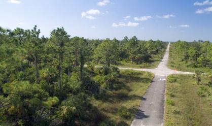
6 Golden Gate Estates Canal Systems


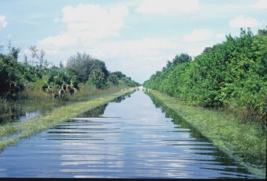
7 Wet Season: Miller Blvd.

8 30+ yrs later Not only is Golden Glades Estates entirely unworkable and hopeless with regard to urban development outlook, it also violates all know naturalresource management principles and practices William Vines; former Naples Land Planner

9 Building the puzzle Rural Development Picayune Strand State Forrest Rookery Bay National Estuarine Research Preserve Collier Seminole State Park 10,000 Islands National Wildlife Refuge Florida Panther National Wildlife Refuge Big Cypress National Preserve Fakahatchee Strand State Preserve Everglades National Park Restores ecological connectivity between publicly owned lands Picayune Strand

10 Conservation areas surrounding Picayune Strand Restoration Project


11 1998 Southern Golden Gate Estates was identified as an essential part of the effort to restore the Western Everglades
 $375,330,000 (Federal $187,665,000; Non- Federal $187,665,000).")
12 Authorization WRDA (2007) CERP PICAYUNE STRAND RESTORATION PROJECT, COLLIER COUNTY, FLORIDA USACE Chief of Engineers Report (September 15, 2005) $375,330,000 (Federal $187,665,000; Non- Federal $187,665,000).
 Removing and degrading 260 miles")
13 The Restoration Project Restore 55,000 acres of native Florida wetlands and uplands Project Features 3 spreader canals 3 pump stations: Merritt, Faka Union, and Miller Plugging 48 miles of canals (with more than 100 plugs) Removing and degrading 260 miles of roads
14 Purpose and Benefits Improve aquifer recharge to protect water supply and prevent saltwater intrusion. Restore/enhance habitat for fish and wildlife resources. Maintain existing level of flood protection for Northern Golden Gate Estates and adjacent private properties. Reduce Drainage of Fakahatchee Strand State Preserve. Reduce or eliminate over-drainage of adjacent sensitive ecosystems. Reduce freshwater releases (point discharges) to improve the health and productivity of downstream estuaries. Preserve upland habitat. Control invasive exotic plants. Improve water quality of stormwater runoff. Provide resource-based recreational opportunities. Provide comprehensive habitat conservation for the greater Everglades ecosystem, including: Florida Panther National Wildlife Refuge Fakahatchee Strand State Preserve Ten Thousand Islands National Wildlife Refuge Collier Seminole State Park Belle Meade Conservation and Recreation Lands.
15 N MILES 0 2 I cfs Picayune Strand Restoration Project Private Lands $6M 1250 cfs 2650 cfs Features with Cost 6Ls Levee $12M U.S 41 $10M POI Levee $2M Spreaders Pump Stations Canal Plugs Primary/Secondary All Weather Roads Tie-back Levee Flood Protection Levees (footprints shown from PIR)

16 Flood Protection Features To maintain existing (no project condition) levels of flood protection for adjacent lands Private Lands Port of the Islands 6Ls Farm

17 Private Lands 6Ls Farm Port of the Islands
 to")

18 H&H Modeling Acceler8 model Hydraulic Design Tool (HDT) to design proposed project structures Integrated surface/groundwater MShe/M11


19 Airport Rd Canal I-75 Canal Orange Tree GG Main Miller Faka Union Prairie Soil Distribution "! 82 ø 850.-, 75 ø 846 "! 29 Cocohatchee ø 858 (/ 41 Harvey GG Main C-1 Cypress.-, 75 Model Data Henderson Creek (/ 41 Merritt "! 29 sets Major Roads Canals Soil_distrib Immokalee Boca Riviera Sanibel Winder Plantation Miles N DEPARTMENT OF THE ARMY JACKSONVILLE DISTRICT, CORPS OF ENGINEERS JACKSONVILLE, FLORIDA Comprehensive Everglades Restoration Plan Southern Golden Gate Estates Project Implementation Report SOUTH FLORIDA WATER MANAGEMENT DISTRICT
20 Do we need to re-do this again? H&H Design Objective To comply with current USACE guidelines and regulations for levee/dam safety Assess residual risk by examining consequences of design capacity exceedence events
21 Some of the ER s, EM s, ETL s EM (Engineering and Design - RISK-BASED ANALYSIS FOR FLOOD DAMAGE REDUCTION STUDIES) EM (Engineering and Design - DESIGN AND CONSTRUCTION OF LEVEES) EM (Hydrologic Frequency Analysis) EM (Engineering and Design - FLOOD-RUNOFF ANALYSIS EM (Engineering and Design - INSTRUMENTATION OF EMBANKMENT DAMS AND LEVEES) ER (Planning - PLANNING GUIDANCE NOTEBOOK) ER (Planning RISK ANALYSIS FOR FLOOD DAMAGE REDUCTION STUDIES) ETL Engineering and Design - GUIDELINES FOR LANDSCAPE PLANTING AND VEGETATION MANAGEMENT AT LEVEES, FLOODWALLS, EMBANKMENT DAMS, AND APPURTENANT STRUCTURES) ETL (Engineering and Design - INSTRUMENTATION OF EMBANKMENT DAMS AND LEVEES) ETL (Engineering and Design - OVERTOPPING OF FLOOD CONTROL LEVEES AND FLOODWALLS) (Restricted Use) EC (Engineering and Design - USACE PROCESS FOR THE NATIONAL FLOOD INSURANCE PROGRAM (NFIP) LEVEE SYSTEM EVALUATION) The National Levee Safety Act of 2007, Title IX of WRDA 2007 Flood Risk Management Executive Order (EO 11988)

22 Model Migration from ACCELER8 Parsons AE Model to GSSHA
23 Model Purpose Determine hydraulic design criteria for the protective features per the new ER s-em s-etl s Port of the Islands Private Lands 6L s

24 Tiered Modeling Scales
25 Modeling Approach 1. Model Migration Existing Mike She/Mike 11 Models (PIR Models) Gridded Surface Subsurface Hydrologic Analysis (GSSHA) 2. Develop Tier 1 Models Low resolution, large domain Calibration: 1995 Storm Event (Tropical Storm Jerry) Develop existing and with project conditions 3. Develop Tier 2 Models High resolution, reduced domain High level of detail wrt Tier 1 models Design criteria

26 Tier 1 Model Calibration Calibration Gauges
27 Stage, ft Bridge 36-Tomato Rd Simulated Observed Stage, ft FU 1 Simulated observed 0.0 8/19 8/21 8/23 8/25 8/ /19 8/21 8/23 8/25 8/27 Stage, ft Bridge Simulated 0.7 Observed /19 8/21 8/23 8/25 8/27 8/29 Flow, cfs FU Simulated 70 Observed /19 8/21 8/23 8/25 8/27
28

29 Depth Difference Map: 10-yr Storm Frequency

30 Depth Difference Map: 100-yr Storm Frequency

31 Port of the Islands Tier 2 Model 10yr 100yr Differences < 0 i.e., with < without
32 Profile along north-south direction of proposed levee alignment Port of the Islands Water Surface Profiles 1.20 Elevation (m) Station (m) W ell Rd Embankment US 41 Embankmen t el 3.25 m Ground El Yr WS Condition YR WS Condition Yr WS Condition Yr WS Condition


33 Do we need POI Levee? Improvements in Topo DEM wrt data source in PIR model ($ Savings)

34 Private Lands Tier 2 Model

35 6Ls Tier 2 Model
36 N MILES 0 2 I cfs Picayune Strand Restoration Project Private Lands $6M 1250 cfs 2650 cfs Features with Cost 6Ls Levee $12M U.S 41 $10M POI Levee $2M Spreaders Pump Stations Canal Plugs Primary/Secondary All Weather Roads Tie-back Levee Flood Protection Levees (footprints shown from PIR)
37 N MILES 0 2 I cfs Picayune Strand Restoration Project Private Lands < $6M 1250 cfs 2650 cfs Features with Cost 6Ls Levee < $12M U.S 41 $10M POI Levee $0 M Spreaders Pump Stations Canal Plugs Primary/Secondary All Weather Roads Tie-back Levee Flood Protection Levees (footprints shown from PIR) Eliminated based on GSSHA Modeling
38 Design Criteria Superiority Analysis Levee crest at least 2ft > than 95% CI for 100yr storm Pump stations Tieback system Crest 15ft (NAVD88) 6L s farm levee TBD
39 Summing up SGGE unsuccessful urban development attempt turned into successful restoration project Benefits identified in restoring PSRP H&H modeling to help with design and refinement of PSRP flood control protective features per current USACE guidelines Other issues identified
40 Never ending H&H modeling GW impacts to 6L farms > seepage rates = mitigation measures < seepage = > pump irrigation costs US41 Road bed impacts Drainage issues to TTINWR Red-cockaded woodpecker habitat impacts


41 41 PSRP Success!


42 42 PSRP Successes PM: Is the H&H analysis Evidence of complete? Restoration in Prairie Canal Restoration Area Panther sightings Increase in bird population ExoticDrainage species control H&H eng.: We just found another basin we need to include
Coastal Planning in Texas. Tony Williams Senior Director of Planning Coastal Resources Division Texas General Land Office
 Coastal Planning in Texas Tony Williams Senior Director of Planning Coastal Resources Division Texas General Land Office e The Texas General Land Office (GLO) and the Texas Coast Since 1836: Manager of
COLLIER BOULEVARD (CR 951) CORRIDOR
 CORRIDOR") Project(s) Goals Improve Traffic Circulation, Capacity & Safety Focus on Safety During Design & Construction Address Public Concerns Design an Aesthetically Pleasing Project Limit Environmental Impacts
Project(s) Goals Improve Traffic Circulation, Capacity & Safety Focus on Safety During Design & Construction Address Public Concerns Design an Aesthetically Pleasing Project Limit Environmental Impacts
Appendix E Preliminary Location Hydraulic Study
 Appendix E Prepared for: State of Alaska Department of Transportation and Public Facilities Prepared by: HDR Alaska, Inc. 2525 C Street, Suite 305 Anchorage, Alaska 99503 February 2014 This page intentionally
Recent Tidal Creek Restoration Efforts in Tampa Bay
 Recent Tidal Creek Restoration Efforts in Tampa Bay Ed Sherwood Tampa Bay Estuary Program Co-Authors: Brandt Henningsen, SWFWMD, SWIM Overview Tampa Bay Watershed & Tidal Creek Overview Habitat Restoration
CONSERVATION ELEMENT GOALS, OBJECTIVES, AND POLICIES
 CONSERVATION ELEMENT GOALS, OBJECTIVES, AND POLICIES Goal 4 To conserve, manage, appropriately use and protect the natural resources of the City ensuring continued resource availability and environmental
Canyon Lake Master Plan Revision Public Information Meeting March 18, 2016
 Canyon Lake Master Plan Revision Public Information Meeting March 18, 2016 Marcus Schimank Canyon Lake Manager Capital Regional Office U.S. Army Corps of Engineers Fort Worth District US Army Corps of
Commercial Launch Site Addendum to Wetland Mitigation Plan. Revision 2. April 25, SpaceX Proprietary
 Commercial Launch Site Addendum to Wetland Mitigation Plan Revision 2 April 25, 2017 SpaceX Proprietary Contents 1.0 Project Information... 1 1.1 Background... 1 2.0 Compensatory Mitigation... 2 2.1 Goals
Lewisville Lake Master Plan Revision Public Information Meeting May 2 & 4, 2017
 Lewisville Lake Master Plan Revision Public Information Meeting May 2 & 4, 2017 Presented By Rob Jordan Lake Manager U.S. Army Corps of Engineers Fort Worth District US Army Corps of Engineers Purpose
Florida Forever Conservation Needs Assessment Overview Maps
 Florida Forever Conservation Needs Assessment Overview Maps Prepared by Florida Natural Areas Inventory, The maps in this document are derived from the Florida Forever Conservation Needs Assessment, an
Fisher Slough Tidal Marsh Restoration Project Scaling Down the Restoration Planning & Analysis Framework to Evaluate Project Alternatives
 Fisher Slough Tidal Marsh Restoration Project Scaling Down the Restoration Planning & Analysis Framework to Evaluate Project Alternatives Project Sponsor/Partners The Nature Conservancy Dike District #3
Riparian Buffer on the Bushkill Creek. Policies
 Riparian Buffer on the Bushkill Creek Riparian buffers provide numerous benefits to landowners and the community by protecting groundwater recharge areas, providing flood control, providing stormwater
Regional Restoration Planning:
 Regional Restoration Planning: A Case Study in Collaborative Restoration Science and Planning Campbell Ingram, Executive Officer NCER August 28, 2018 Co-Equal Responsibilities Act as a primary state agency
Stormwater Regulations & Considerations Morse Study Area. Pam Fortun, P.E. CFM Senior Stormwater Treatment Engineer Engineering Services Division
 Stormwater Regulations & Considerations Morse Study Area Pam Fortun, P.E. CFM Senior Stormwater Treatment Engineer Engineering Services Division Stormwater Regulations Development Considerations Floodplain
Terra Nova Rural Park Plan
 Terra Nova Rural Park Plan Part 1 Getting to know the land The Surrounding Area North Side Airport, River, Trail East Side - Residential West Side- Sturgeon Banks, West Dyke Trail South Side:Terra Nova
EXHIBIT A CITY OF FORT WALTON BEACH, FLORIDA COASTAL MANAGEMENT & CONSERVATION
 EXHIBIT A CITY OF FORT WALTON BEACH, FLORIDA INTRODUCTION The Coastal Management and the Conservation Elements required by Chapter 9J-5.012 and 5.013, F.A.C., respectively, have been combined into one
Planning for Staten. Habitat Restoration and Green Infrastructure. Island s North Shore
 Habitat Restoration and Green Infrastructure Planning for Staten Island s North Shore Community Board 1 March 1, 2018 NYC Parks Forestry, Horticulture, and Natural Resources Funded by the NYS Department
The Napa River Flood Protection Project
 The Napa River Flood Protection Project Creating Flood Protection and Restoring Geomorphic and Biological Processes Jeremy Sarrow, Napa County Flood Control & Water Conservation District June 2, 2014.
Peoria Riverfront Development (Ecosystem Restoration) Upper Mid-sized Island Critical Restoration Project (September 2011)
 Upper Mid-sized Island Critical Restoration Project (September 2011)") Peoria Riverfront Development (Ecosystem Restoration) Upper Mid-sized Island Critical Restoration Project (September 2011) Description The Corps of Engineers, Rock Island District (District) and the Illinois
Peoria Riverfront Development (Ecosystem Restoration) Upper Mid-sized Island Critical Restoration Project (September 2011) Description The Corps of Engineers, Rock Island District (District) and the Illinois
continues in the watershed, additional flood control and water quality / natural system improvements may be required in the future.
 The Duck Pond Watershed is located in northern Hillsborough County in an area in which a number of land and water management issues are currently being addressed by citizen's action groups and state, regional
Environmental Resources Branch
 I REPLY TO ATEMION OF DEPARTMENT OF THE ARMY U.S. ARMY ENGINEER DISTRICT, SACRAMENTO CORPS OF ENGINEERS 1325 J STREET SACRAMENTO, CALIFORNIA 95814-2922 Environmental Resources Branch Mr. Milford Wayne
A TWENTY YEAR PLAN TO RESTORE NAPLES BAY. Natural Resources Manager
 A TWENTY YEAR PLAN (and visionary guide) TO RESTORE NAPLES BAY Michael R. Bauer, Ph.D. Natural Resources Manager City of Naples City of Naples Natural Resources Division Management Science Restoration
Broward County Shore Protection Project Segment II. Physical Monitoring Plan
 Broward County Shore Protection Project Segment II USACE File No. SAJ-1999-05545 Broward County Shore Protection Project -Segment II Submitted To: Florida Department of Environmental Protection Office
Appendix A Basin Inventory Summary
 Appendix A Basin Inventory Summary Surface Water Management Element A-1 BASIN INVENTORY SUMMARY Pinellas County is divided into 52 individual watersheds. The following Basin Inventory Summary includes
Northeast Florida Estuary Restoration Initiative: A District Perspective. Ron Brockmeyer, SJRWMD And a cast of thousands!!
 Northeast Florida Estuary Restoration Initiative: A District Perspective Ron Brockmeyer, SJRWMD And a cast of thousands!! Success and Local Partners Impoundment Reconnection / Restoration (Merritt Island
Section 3 Non-Structural BMPs
 3.1 Stream Buffers A stream buffer or stream setback is a designated area around a stream, lake, or wetland left in a natural, densely vegetated state so as to protect the receiving water quality and provide
Bay County RESTORE Act Direct Component Proposals
 Proj # Bay PRP 2014-033 Project Name Mid City Stormwater Project Project Proposer, affiliation, web site Candis Harbison Bay County Conservancy, Inc. www.baycountyconservancy.org Add 2.16 acres to existing
ROLE OF LANDSCAPE CONSERVATION COOPERATIVES IN EVERGLADES RESTORATION
 ROLE OF LANDSCAPE CONSERVATION COOPERATIVES IN EVERGLADES RESTORATION GEER April 2017 Steve Traxler 1, Todd Hopkins 1, Beth Stys 2 1 US Fish and Wildlife Service 2 Florida Fish & Wildlife Conservation
Improving Communities Through the Arroyo Seco Sustainability Campaign and Watershed Assessment
 Improving Communities Through the Arroyo Seco Sustainability Campaign and Watershed Assessment Arroyo Seco Headwaters in the San Gabriel Mountains Major tributary to the Los Angeles River 44 square mile
Peninsular Florida Landscape Conservation Cooperative. Marine and Estuarine Priority Resources and Conservation Targets
 Peninsular Florida Landscape Conservation Cooperative Marine and Estuarine Priority Resources and Conservation Targets Why are we here today? Workshop Goals: Develop a list of potential conservation targets
MEMORANDUM. September 10, 2018
 September 10, 2018 MEMORANDUM TO: Chad Bird, City of Decorah FROM: Larry Weber and Dan Gilles, Iowa Flood Center, IIHR Hydroscience & Engineering COPY TO: Dana Werner, St. Paul District Corps of Engineers,
SUMMARY. Support the Southeast Arkansas Regional Intermodal Facility.
 SUMMARY THE I-69 LOCATION STUDY The proposed I-69 Location Study from El Dorado to McGehee, Arkansas, represents one section (Section of Independent Utility No. 13) of the nationally designated I-69 Corridor
Joe Pool Lake Master Plan Revision Public Information Meeting May 23, 2017
 Joe Pool Lake Master Plan Revision Public Information Meeting May 23, 2017 Presented By Jason Owen Lake Manager U.S. Army Corps of Engineers Fort Worth District US Army Corps of Engineers Purpose of this
Pontchartrain Coastal Lines of Defense Program Figure 1 Figure 2 Figure 1
 Pontchartrain Coastal Lines of Defense Program Coastal Sustainability Program February 2006 The Pontchartrain Coastal Lines of Defense Program consists of ten priority project areas within the Pontchartrain
Public Information Meeting
 Lavon Lake Master Plan Revision Public Information Meeting March 10, 2015 Presented By Michael Kinard Lake Manager U.S. Army Corps of Engineers Fort Worth District US Army Corps of Engineers Purpose of
North Branch of Cypress Creek Ecological Restoration: A Comprehensive Approach to Stream Restoration
 North Branch of Cypress Creek Ecological Restoration: A Comprehensive Approach to Stream Restoration Rocky Powell Clear Creeks Consulting, LLC Keith D. Tate, P.E. BayLand Consultants & Designers, Inc.
WASHINGTON COUNTY OREGON
 WASHINGTON COUNTY OREGON LONG RANGE PLANNING DIVISION North Bethany Subarea Stream Corridors: Existing Regulations In Oregon, there is a distinct difference between the land use rules that apply in rural
AGENCIES and OFFICIALS CONTACTED FEDERAL Federal Aviation Administration Federal Emergency Management Agency Natural Resources Conservation Service U.
 AGENCIES and OFFICIALS CONTACTED FEDERAL Federal Aviation Administration Federal Emergency Management Agency Natural Resources Conservation Service U.S. Army Corps of Engineers U.S. Environmental Protection
Pine Flat Lake Master Plan Update FACT SHEET September 2014
 Pine Flat Lake Master Plan Update FACT SHEET September 2014 PURPOSE AND OBJECTIVE The U.S. Army Corps of Engineers Sacramento District is revising the 1976 Pine Flat Lake Master Plan and is seeking public
Staff will be providing an overview of the project need, purpose and intent for consideration as part of the Amendment cycle.
 Agenda Item D-2 City of Tacoma Planning and Development Services To: Planning Commission From: Stephen Atkinson, Planning Services Division Subject: Open Space Corridors Project Meeting Date: March 1,
GREEN SHEET ENVIRONMENTAL COMMITMENTS FOR THE IOWA HIGHWAY 100 EXTENSION
 County: Linn County, IA GREEN SHEET Location: IA 100, from its terminus at Edgewood Rd. to US 30 southwest of Cedar Rapids Route: IA 100 Extension Project No.: NHS-100-1(36) 19-57 OLE Project Managers:
Draft Rhode Island Stormwater Design and Installation Standards Manual
 Draft Rhode Island Stormwater Design and Installation Standards Manual Summary The May 2009 Public Review Draft version of the RI Stormwater Design and Installation Standards Manual consists of approximately
U.S. Army Corps of Engineers, Los Angeles District Prado Basin Project Updates
 U.S. Army Corps of Engineers, Los Angeles District Prado Basin Project Updates Host: Inland Empire Utilities Agency January 19, 2017 10:00 a.m. Purpose: To provide project overviews and updates to regional
City of Norfolk Coastal Flood Mitigation Program. March 13, 2013
 City of Norfolk Coastal Flood Mitigation Program March 13, 2013 Topics Brief overview of Norfolk s Coastal Flood Program Data-driven analysis and decision making City-wide vulnerability, project concepts,
COMMUNITY DEVELOPMENT SERVICES PLANNING AND BUILDING DEPARTMENT PLACERVILLE OFFICE:
 COMMUNITY DEVELOPMENT SERVICES PLANNING AND BUILDING DEPARTMENT http://www.edcgov.us/devservices/ PLACERVILLE OFFICE: LAKE TAHOE OFFICE: 2850 Fair Lane Court, Placerville, CA 95667 924 B Emerald Bay Rd.
Baylands Segment J. Bay between the Golden Gate and Segment J. Coyote Point. of For managed ponds. included habitat enhancement.
 Baylands Segment J Crissy Field Alameda Naval Air Station Heron's Head Park COLMA CREEK SFO Millbrae San Mateo BAYLANDS 2009 SAN FRANCISCO AREA san francisco area Western side of central San Francisco
MEMORANDUM. Council Meeting of June 7, 2007
 7 i CITY OF ST. PETERSBURG MEMORANDUM Council Meeting of June 7, 2007 TO : Members of City Council FROM : Mayor Rick Baker P4:~ (S ck- RE : Confirmation of Reappointment and Appointment to the Planning
NAI Principles In Gwinnett County
 NAI Principles In Gwinnett County By Cornelius Ani, LSIT, CFM Contributors: Adena Fullard, P.E., CPSWQ Rudresh Bihalli, P.E., CFM Ken Kagy, P.E., CPESC, CPSWQ Ligia Negru, M. Sc., CFM Maja Radovic, CPESC,
Community LID Workgroup Issue Paper #6
 Community LID Workgroup Issue Paper #6 Topic: Hard and Impervious Surface Coverage Limits Objective: Minimize the amount of hard and impervious surfaces in developments to allow more stormwater to infiltrate
Floodplain Technical Memorandum
 Southeast Extension Project Lincoln Station to RidgeGate Parkway Prepared for: Federal Transit Administration Prepared by: Denver Regional Transportation District May 2014 Table of Contents Page No. Chapter
Methods to Simulate the Impact of BMPs
 LA221 Project Ortega Watershed Demonstration Area, Quito Ecuador Ricardo da Cruz e Sousa Master of Landscape Architecture & Environmental Planning University of California, Berkeley December 2011 Ortega
MDX SR 836/DOLPHIN EXPRESSWAY SOUTHWEST EXTENSION
 MDX SR 836/DOLPHIN EXPRESSWAY SOUTHWEST EXTENSION Project Development and Environment (PD&E) STUDY Miami-Dade County, Florida Preliminary Executive Summary Alternative Corridor Evaluation (ACE) Report
Pond Siting Report Update
 Pond Siting Report Update Prepared for: Florida Department of Transportation District 5 CR 46A Realignment from SR 46 to North of Arundel Way Lake County, Florida FPID No. 238275-8-32-02 October 2013 (Draft
CHECKLIST FOR PHASE II DRAINAGE REPORT
 I. COVER SHEET CHECKLIST FOR PHASE II DRAINAGE REPORT A. Name of Project B. Address C. Owner D. Developer E. Engineer F. Submittal date and revision dates as applicable II. GENERAL LOCATION AND DESCRIPTION
Adaptation and Resilience at the City of Fort Lauderdale
 Adaptation and Resilience at the City of Fort Lauderdale Carlos Acosta, P.E. Assistant City Engineer City of Fort Lauderdale Overview Climate challenges and limitations Sea Level Rise Projections King
Understanding Drainage Options What s Feasible and Legal. February 2019
 Understanding Drainage Options What s Feasible and Legal February 2019 Outline for the Presentation Do you need a permit? Does common law apply? Does local government approve it? Will my neighbor allow
OBJECTIVES OF THE GREENSPACE PLAN
 4 Greenspace Manual OBJECTIVES OF THE GREENSPACE PLAN Page 4.2 THE GREENSPACE MODEL Page 4.2 ANALYSIS OF EXISTING CONDITIONS Page 4.3 Parks Page 4.3 Natural Lands Page 4.6 Linkages Page 4.8 Population
Photo by Carlton Ward Jr. Executive Summary
 Photo by Carlton Ward Jr. Executive Summary The Cooperative Conservation Blueprint (Blueprint) is a multi-partner strategic conservation process developed by the Florida Fish and Wildlife Commission (FWC)
SR 836 Southwest Extension
 SR 836 Southwest Extension Miami-Dade County, Florida August 8, 2018 MDX WORK PROGRAM NO.: 83618 Project Need Population growth and traffic in southwest Miami-Dade has significantly increased without the
RESPONSES TO PUBLIC CONCERNS AND QUESTIONS
 RESPONSES TO PUBLIC CONCERNS AND QUESTIONS Stations and Summary Questions for Public Meeting #2 June 23, 2015 General Questions / Concerns: 1. Is there any way this development can raise revenue for the
July 22, 2013 REQUEST FOR PROPOSALS TO PROVIDE ENGINEERING DESIGN SERVICES FOR A PROJECT ALONG THE WESTERN SHORE OF MOBILE BAY
 Mobile Bay National Estuary Program 4172 Commanders Drive Mobile, AL 36615 Phone: 251-431-6409 Fax: 251-431-6450 Contact: Tom Herder, Watershed Protection Coordinator Email: therder@mobilebaynep.com July
SOUTH FLORIDA ECOSYSTEM RESTORATION TASK FORCE SCG SPONSORED PUBLIC WORKSHOP ON SCIENCE CENTRAL EVERGLADES PLANNING PROJECT MINUTES
 SOUTH FLORIDA ECOSYSTEM RESTORATION TASK FORCE SCG SPONSORED PUBLIC WORKSHOP ON SCIENCE CENTRAL EVERGLADES PLANNING PROJECT MINUTES February 13, 2012 9:30 AM District Headquarters - B-1 Auditorium 3301
Policy & Procedure Effective Date: Parks Department Page of
 City of Arvada Policy & Procedure Effective Date: Parks Department Page of TITLE: City of Arvada Prairie Dog Habitat Plan APPROVAL: PURPOSE: To establish a plan for the preservation of black-tailed prairie
8.5 FLOODING. Environmental Setting
 8.5 FLOODING This section evaluates flooding impacts associated with the proposed General Plan, including whether implementing the plan will: (1) permit the construction of housing within a 100-year Flood
DRAFT Subject to Modifications
 DRAFT Subject to Modifications TREASURE COAST REGIONAL PLANNING COUNCIL M E M O R A N D U M To: Council Members AGENDA ITEM 10 From: Date: Subject: Staff February 19, 2016 Council Meeting Local Government
City of Shady Cove Riparian Ordinance Ordinance XXX
 1 Updated October 8, 2015 City of Shady Cove Riparian Ordinance Ordinance XXX This language is to be located in Chapter 155 of the Shady Cove Code of Ordinances. This will affect property inside city limits,
National Association of Conservation Districts. Kris Hoellen Vice President, Sustainable Programs The Conservation Fund September 19, 2013
 National Association of Conservation Districts Kris Hoellen Vice President, Sustainable Programs The Conservation Fund September 19, 2013 Our Mission The Conservation Fund forges partnerships to conserve
Greenways as an alternative to traditional infrastructure. Green Infrastructure
 Greenways as an alternative to traditional infrastructure Green Infrastructure What is a Greenway? Little (1990) - A linear open space along a natural or human made corridor. Fabos - linked corridors nature
Zoning Ordinance Article 3
 Article 3 Natural Resources Protection Section 301 Natural Resources Protection 301.1. Purpose - The following natural resources protection standards are established to protect the public health, safety
Master Land Use Plan Application
 Development Review Division Development Services Department CITY OF OVIEDO 400 Alexandria Boulevard Oviedo, Florida 32765 Application No. Date Received Phone: (407) 971-5775 Fax: (407) 971-5819 www.cityofoviedo.net
WARSAW WAL-MART EXPANSION FLOODPLAIN EVALUATION STUDY
 WARSAW WAL-MART EXPANSION FLOODPLAIN EVALUATION STUDY BERGMANN ASSOCIATES NOVEMBER 20, 2008 (revised June 8, 2009) TOWN OF WARSAW, WYOMING COUNTY, NEW YORK Memorandum To: Jack Buholtz, PE From: Kenneth
Wetland Types. Grade Level: Basic. Duration: 30 minutes. Setting: Classroom
 Wetland Types Adapted from: An original Creek Connections activity created by Cassandra Hamilton. Creek Connections, Box E, Allegheny College, Meadville, PA 16335 http://creekconnections.allegheny.edu
Natomas Joint Vision Open Space Plan
 Natomas Joint Vision Open Space Plan First Workshop series The City of Sacramento The County of Sacramento LAFCo ERA Economic Research Associates EIP Associates a Division of PBS & J Natomas Joint Vision
Restoring Water Ecosystems in NYC Parks
 Restoring Water Ecosystems in NYC Parks Hooked on our Waters Con October 19, 2013 - CUNY Graduate Center Marit Larson NYC Parks Landscape and ecosystem focus Watershed Streams Freshwater wetlands Tidal
Template for Restoration in a Lake Superior Area of Concern. Template for Restoration in a Lake Superior Area of Concern
 Keith Bowers, Principal Ivette Bolender, Great Lake Bioregion Team Leader Presentation outline: Project background Master planning process Habitat restoration approach Lessons learned Hog Island and Newton
Ecosystem Restoration Business Line Budgeting A Systems Approach
 Ecosystem Restoration Business Line Budgeting A Systems Approach Laura Orr (NWS), Shawn Phillips (MVM), Greg Steele (NAO) Introduction Chesapeake Bay Bridge Mouth of Mississippi River Bonneville Dam Fish
Department of Community Development. Planning and Environmental Review Division Revised Notice of Preparation
 Department of Community Development Michael J. Penrose, Acting Director Divisions Building Permits & Inspection Code Enforcement County Engineering Economic Development & Marketing Planning & Environmental
DRAFT MAP AMENDMENT FLU 04-4
 DRAFT MAP AMENDMENT FLU 04-4 SW 24 TH AVENUE ROADWAY CORRIDOR The University of Florida participates with the Metropolitan Transportation Planning Organization (MTPO) in its responsibilities for the continuing,
CONSERVATION ELEMENT. LISTED SPECIES Those species designated as endangered, threatened, or of special concern.
 CONSERVATION ELEMENT Definitions: LISTED SPECIES Those species designated as endangered, threatened, or of special concern. PROTECTED Refers to official federal, state, or internationally treaty lists
CONSERVATION ELEMENT:
 CONSERVATION ELEMENT: Goals, Objectives and Policies Goal 1: To conserve, protect and enhance the functions and values of the natural resources within Jupiter to ensure the highest environmental quality
DETERMINATION OF SIGNIFICANCE FOR THE LONGWOOD PUBLIC LIBRARY EXPANSION & RENOVATION; STATE ENVIRONMENTAL QUALITY REVIEW ACT (SEQRA) RESOLUTION
 RESOLUTION") Longwood Public Library Resolution Library Board of Trustees August 13, 2012 DETERMINATION OF SIGNIFICANCE FOR THE LONGWOOD PUBLIC LIBRARY EXPANSION & RENOVATION; STATE ENVIRONMENTAL QUALITY REVIEW ACT
Longwood Public Library Resolution Library Board of Trustees August 13, 2012 DETERMINATION OF SIGNIFICANCE FOR THE LONGWOOD PUBLIC LIBRARY EXPANSION & RENOVATION; STATE ENVIRONMENTAL QUALITY REVIEW ACT
There is an ongoing regulatory concern that
 FWRJ Alternatives for Beach Stormwater Outfalls: Preliminary Assessment for City of Naples Reshma Thummadi, Ronald Cavalieri, Andy Holland, and Gregg Strakaluse There is an ongoing regulatory concern that
The Trinity River Corridor Project Update
 The Trinity River Corridor Project Update Councilmember Carolyn A. Davis Community Meeting October 14, 2008 The project covers 20 miles of the Trinity River, approx. 10,000 acres 2 Trinity River Corridor
Working Group Meeting
 April 4,, 2017 Parks Operations Bldg Working Group Meeting Arts Districts Overview Stormwater/RPA/Stream Considerations First Principles Agenda 7:00pm 7:05pm 7:10pm 7:40pm 8:30pm 9:40pm 9:45pm Welcome
COUNTY OF PRINCE WILLIAM 5 County Complex Court, Suite 120 Prince William, Virginia (703) Metro Fax: (703)
 Metro Fax: (703)") COUNTY OF PRINCE WILLIAM 5 County Complex Court, Suite 120 Prince William, Virginia 22192-5308 (703) 792-6930 Metro 631-1703 Fax: (703) 792-5285 DEPARTMENT OF DEVELOPMENT SERVICES Wade A. Hugh Director
COUNTY OF PRINCE WILLIAM 5 County Complex Court, Suite 120 Prince William, Virginia 22192-5308 (703) 792-6930 Metro 631-1703 Fax: (703) 792-5285 DEPARTMENT OF DEVELOPMENT SERVICES Wade A. Hugh Director
What Can We Do to Reduce the Impact of Floods? Joe Barron, P.E. Fletcher Group, Inc. 148 River St. Suite 220 Greenville, S.C.
 What Can We Do to Reduce the Impact of Floods? Joe Barron, P.E. Fletcher Group, Inc. 148 River St. Suite 220 Greenville, S.C. 29601 1 Historical highlights of flood management attempts 1726 first New Orleans
Appendix E: Illustrative Green Infrastructure Examples
 Appendix E: Illustrative Green Infrastructure Examples Integrating LID into San Francisco s Urban Landscape Figure E. High-density Residential Figure E. Low-density Residential Figure E. Mixed Use 7 Figure
Ted Perkins, Hydraulic Engineer US Army Corps of Engineers, Seattle District 8/9/2007
 Skagit River Revised Flood Insurance Study Levee Scenario Discussion Ted Perkins, Hydraulic Engineer US Army Corps of Engineers, Seattle District 8/9/2007 Skagit Levee Failure Scenarios Challenges of Defining
- Phase. Project. areas using. project from. Project Type: Project is
 Model Community Watershe ed Development - Phase I / Marais des Cannes Location: Lafayette Parish / Scott, LA Client: State of Louisiana / Office of Community Development Disaster Recovery Unit Design Firm(s):
What Does It Take? Constructing Ponds and Water Features
 Constructing Ponds and Water Features What Does It Take? The information in this publication is intended for informational purposes and while all effort has been made to present accurate information, the
Presentation to Parks and Open Space Advisory. Committee September 22, 2016
 Flood Planning & Preliminary Design Services for South St. Vrain Creek Restoration at Hall Ranch Presentation to Parks and Open Space Advisory Prepared for: Boulder County, Colorado Committee September
CECW-AG 11 June 1998 MEMORANDUM FOR MAJOR SUBORDINATE COMMANDS AND DISTRICT COMMANDS
 CECW-AG 11 June 1998 MEMORANDUM FOR MAJOR SUBORDINATE COMMANDS AND DISTRICT COMMANDS SUBJECT: Policy Guidance Letter No. 59, Recreation Development at Ecosystem Restoration Projects 1. References: a. ER
STREAM BUFFERS
 88-415 STREAM BUFFERS 88-415-01 PURPOSE In the Kansas City region and throughout the nation, vegetated stream buffers have been clearly shown to protect stream stability and related infrastructure, improve
Design Guidelines for the Enhancement and Creation of Estuarine Habitats in the Middle Reaches of the Lower Columbia River
 Design Guidelines for the Enhancement and Creation of Estuarine Habitats in the Middle Reaches of the Lower Columbia River Astoria, May 16, 2012 1 Outline I. Nature of Project/Background II. Approach to
Chapter 5: Natural Resources and Environment
 NATURAL RESOURCES AND ENVIRONMENT 5-1 5 Chapter 5: Natural Resources and Environment BACKGROUND AND INTENT Urban expansion represents the greatest risk for the future degradation of existing natural areas,
Gadsden County Planning Commission Agenda Request
 Date of Meeting: November 16, 2017 To: From: Through: Subject: Gadsden County Planning Commission Agenda Request Honorable Chairperson and Members of the Board Jill A. Jeglie, AICP, Senior Planner Clyde
NAPA COUNTY PUBLIC WORKS Standards & Specifications
 Roadway Design & Construction Manual (Table of Contents) 1. Chapter 1: General Provisions 1.1 Short Title 1.2 Jurisdiction 1.3 Purpose and Effect 1.4 Enactment Authority 1.5 Amendment and Revisions 1.6
ADDENDUM TO BIOLOGICAL SCOPING SURVEY REPORT, BOTANICAL SURVEY AND WETLAND DELINEATION
 ADDENDUM TO BIOLOGICAL SCOPING SURVEY REPORT, BOTANICAL SURVEY AND WETLAND DELINEATION FOR AVALON INN (APN 069-241-27 & -04) 1201 & 1211 NORTH MAIN STREET FORT BRAGG, CA MENDOCINO COUNTY prepared for:
Three Rivers Park District Administration Center Rain Garden
 Three Rivers Park District Administration Center Rain Garden Introduction There are significant changes to the hydrologic regime and nutrient loading following urban and industrial development. The post-development
NDIA Environment, Energy, and Sustainability Symposium & Exhibition Denver, Colorado May 2009
 Energy Independence and Security Act of 2007 (Energy Conservation, Water Conservation, and Community Development) NDIA Environment, Energy, and Sustainability Symposium & Exhibition Denver, Colorado May
January 18, JOINT PUBLIC NOTICE Savannah District/State of Georgia
 DEPARTMENT OF THE ARMY SAVANNAH DISTRICT, CORPS OF ENGINEERS 100 WEST OGLETHORPE AVENUE SAVANNAH, GEORGIA 31401-3640 January 18, 2019 Regulatory Branch SAS-2009-00770 JOINT PUBLIC NOTICE Savannah District/State