Southern Auto Sales, Inc.
|
|
|
- Ernest Goodwin
- 5 years ago
- Views:
Transcription
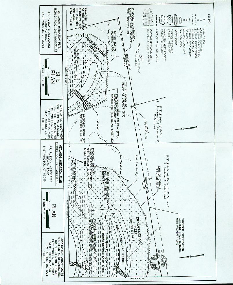
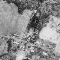
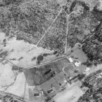
1 Southern Auto Sales, Inc. File No.: City and State: East Windsor, CT General Impacts: 3.8 acres forested Functions and Values Lost: (From EA/SOF) Wildlife Habitat Year(s) Mitigation Constructed: April 2000 Size and Type of Mitigation as Proposed: 8.4 acres forested created off site Proposed Functions and Values of Mitigation: (From Database) Sediment/Toxicant Retention Nutrient Removal Wildlife Habitat Mitigation Special Condition(s): 5. Except where modified by the Special Conditions herein, the mitigation shall be performed in accordance with the attachment mitigation plan entitled Wetlands Mitigation Plan, Trombley Road, East Windsor, Connecticut and dated August 21, To the extent practicable, all plantings shall be done in accordance with the planting plan. During planting, the mitigation specialist cited in the plan, or other as approved by the Corps, may relocate up to 50% of the plantings, if the as built site conditions pose an unreasonable threat to their survival. The plantings shall be relocated to locations with suitable hydrology, soil, and where appropriate structural context with other plantings can be maintained. 6. The mitigation site shall be monitored for a period of three years after construction of the mitigation area is complete. 7. Mitigation projects will not use plant materials that are not native and indigenous to the region. 8. Soils containing the living roots of Typha spp., Phragmites australis or Lythrum salicaria shall not be used in the mitigation area. The following species shall be excluded from all project landscaping plans for areas within 100 feet of the proposed mitigation site: Herbs Echinochloa crusgalli Lythrum salicaria Phragmites australis
2 Typha latifolia T. glauca T. angustifolia Glyceria maxima Phalaris arundinacea Polygonum cuspidatum Woody Plants Ailanthus altissima Berberis thunbergii B. vulgaris Euonymous alatus Ligustrum obtusifolium L. vulgare Lonicera tartarica L. morrowii L. xylosteum Populus alba Robinia pseudoacacia Celastrus orbiculatus Eleagnus angustifolia E. umbellata Juniperus virginiana Wisteria floribunda Rhamnus cathartica R. frangula Rosa multiflora 9. To enhance habitat and avoid disruption of many specialized plant and animal cycles, an adequate supply of dead and dying woody debris shall be left on the ground within the mitigation site after the completion of construction of the mitigation site. As much as possible, these materials should also be in various stages of decomposition and salvaged from natural areas cleared for the other elements of the project. 10. If the plantings are not successful by November 1 of any year during the three year monitoring period, the permittee shall develop and implement a remedial plan to meet the planting success criteria listed below. The remedial plan may include, but is not limited to: removal of debris; replanting, biological-, herbicidal-, or mechanical control of invasive plant species; regarding the site; application of additional topsoil or soil amendments; or adjustments to the hydrology of the site. 11. The mitigation site shall have at least 75% species survival. Percent species survival is the number of surviving plants on the site divided by the number of plants originally planted, multiplied by 100. NOTE: In some circumstances, herbaceous cover may obscure direct observation and tally. In these cases, quadrat samples may be substituted for direct measures.
3 12. All mitigation sites shall have at least 80% areal cover by noninvasive hydrophytes. For the purpose of this performance standard, invasive species of hydrophytes are: Purple Loosestrife Lythrum salicari; Cattails Typhlatifolia, T. angustifolia, T. glauca; Common Reed Phragmites australis; and Reed Canary Grass Phalaris arundinacea. 13. For the first three full years following construction, monitoring reports should be prepared at the end of each full growing season. Reports are due not later than December 15 of the year being monitored. These report shall be submitted to the Chief, Policy Analysis and Technical Support Section, Regulatory Branch, U.S. Army Corps of Engineers, 696 Virginia Road, Concord, Massachusetts for review and inclusion in the permit file. Permit number shall be referenced on all submissions. 14. The following are the minimal components of the annual wetland mitigation monitoring reports: a. A summary of the monitoring inspections that occurred since the last report. b. A checklist of the success standards that indicate which standards were attained and which were not met during the monitoring year. c. A concise description of any remedial actions done during the monitoring year in order to meet the success standards. These activities may include, but are not limited to, removal of debris; replanting; biological-, herbicidal-, or mechanical control of invasive plant species; regarding the site; application of additional topsoil or soil amendments; or adjustments to the hydrology of the site. d. A concise description of other remedial actions done during the monitoring year in order to improve the success potential of the mitigation sites. e. Recommendations for future remedial activities. f. Vegetation Cover Percentages: (1) A visual estimate of total percent cover for each mitigation site. (2) A visual estimate of the percent cover of Lythrum salicaria, Phragmites australis, Typha latifolia, T. Angustifolia, F. glauca, and Phlalaris arundinacea in each mitigation site. g. A description of the general health and vigor of the surviving plants and a prognosis for their future survival. h. A diagnosis of the cause(s) of morbidity or mortality on the site. i. Percent Species Survival expressed as 100 multiplied by the number of surviving plants divided by the number of plants that were originally planted. j. APPENDICES: Appendix A A copy of this special condition for mitigation. Appendix B An as-built landscaping plan identifying the location and extent of the designed plant community types (e.g., shrub swamp). Within each community type, the plan should identify the location and the individual plant species. Appendix C Representative photos of each mitigation site taken from the same locations for each monitoring event.
4 15. A post construction assessment shall be completed after the first five full growing seasons. The report should present conclusions and evidence relating to the overall success of the mitigation project. A basic premise of the permit is that mitigation is successful if the designed features persist. 16. This assessment shall consider the condition of the wetland mitigation sites after the first five full growing seasons following the completion of the construction of the mitigation sites. To ensure objectivity, the persons who prepared the annual monitoring reports shall not prepare this overall appraisal of mitigation unless prior written approval is granted by the Corps. 17. The post-construction assessment for this project shall include at least the following components: a. GOALS: Summarize the original or modified mitigation goals and discuss the level of attainment of these goals at the mitigation site. b. LESSONS LEARNED: As lessons learned provide a brief summary of any significant problems that were encountered or solutions that were developed during the construction and maintenance periods. c. IMPEDIMENTS: Identify any departmental or agency procedures or policies that may have encumbered the implementation of the mitigation designs. Specifically note procedures or policies that contributed to less success or less effectiveness than anticipated in the Corps Environmental Assessment for the project. d. RECOMMENDATIONS: Provide recommendations to improve the efficiency, reduce the cost, or improve the effectiveness of similar projects in the future. e. APPENDICES: Appendix A Summary of the results of a functions and values assessment of the mitigation sites using the same methodology as was used to determine the functions and values for the impacted wetland(s). Appendix B Calculation of the area of wetlands in each mitigation site using the delineation method employed by the Corps of Engineers. Supporting documents will include: a scaled drawing illustrating the wetland boundaries and at least two representative transects with corresponding data points where Wetland Delineation data sheets are prepared. Appendix C Comparison of the measured areas of the delineated wetland area(s) with those area(s) proposed in the mitigation plan. This comparison can be made on a scaled drawing or as an overlay to the as-built plan. This plan should also illustrate the major vegetation community types. Appendix D Photos of the mitigation site taken from the same fixed locations as the monitoring photos. 18. The permittee shall execute and record the attached CONSERVATION and HISTORIAL PRESERVATION EASEMENTS with the attachments referenced in the CONSERVATION and HISTORICAL PRESERVATION EASEMENTS as Exhibit A for Parcels I and Parcel II, with revisions on Parcel I of and on Parcel II , with the registry of deeds for the Town of East Windsor and the State of Connecticut.
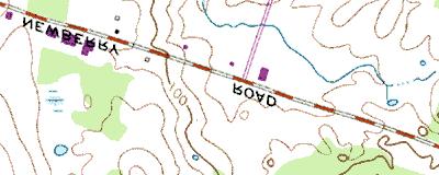
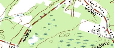
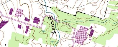
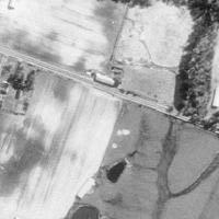
5 These documents shall be registered within 90 days of the date of this permit. A copy of the executed and recorded document must be sent to this office within 30 days of the date it was recorded. Remarks: None Directions: Take 95/128 south toward Dedham/Providence, RI. Take exit 25, I-90/Mass Pike. Go west toward New York/Springfield/Framingham. Take I-84 west to Route 291. Take Route 5 exit, and go north to Tromley Road on the right. The site is on the right behind and to the right of an old tobacco barn. There is a CT DEP sign marking the site. Site is across the street from an unnamed road or long driveway.
6 Street Atlas USA DeLorme. Street Atlas USA MN (14.7 W) TN Scale 1 : 16, ft m 1" = 1330 ft


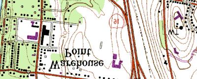
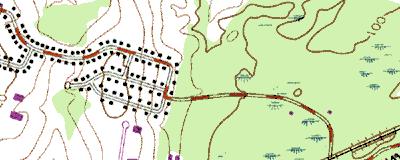
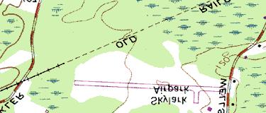
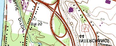
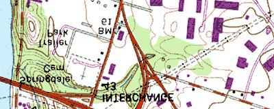
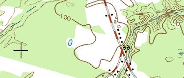
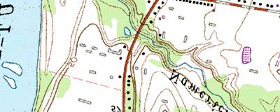
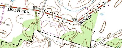
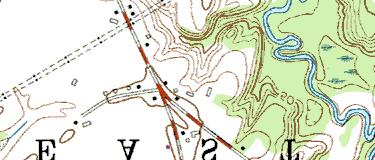
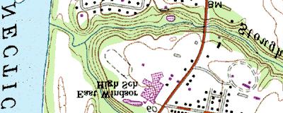
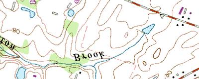
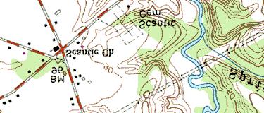
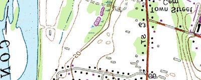
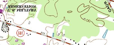
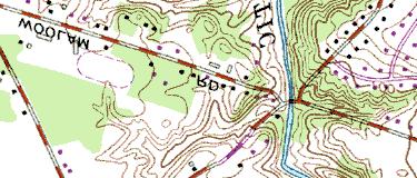
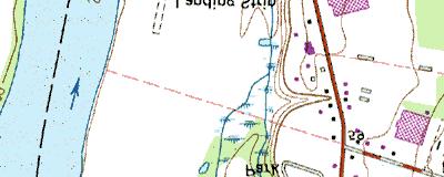
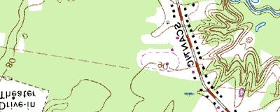
7 Southern Auto Sales Copyright (C) 1997, Maptech, Inc.
8 MITIGATION SITE FIELD DATA FORM Site Name: Southern Auto Sales File No City/Town: East Windsor State: CT Waterbody: Monitor(s): Keith Wright Date: Was site constructed? yes Is site wetland? yes Size of proposed wetland: 8.4 acres Actual size of wetland: much less than 8 acres Landscape position: TBD Lat/Long Points: N W Saved GPS Waypoint name: SAS GPS Tracking Log Name: N/A Perimeter: TBD Surrounding land use: Residential, forest Is wetland function compromised by surrounding land use? No Plant health: Good Invasive species: Lythrum salicaria, Typha latifolia Wildlife use: Birds, frogs, butterfly; cattails eaten Plants: Acer rubrum Alisma sp. Alnus rugosa Betula populifolia Carex lurida Carex sp. (ovales) Carex spp. Carex vulpinoidea Cornus amomum Cyperus strigosus Eupatorium perfoliatum Juncus effusus Lythrum salicaria Phalaris arundinacea Poaceae spp. Rosa sp. Rubus sp. Sagittaria latifolia Scirpus atrovirens Scirpus cyperinus Scirpus validus Solidago sp. Sparganium sp. Typha latifolia Verbena hastata Page 1 of 2
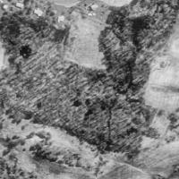
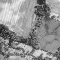
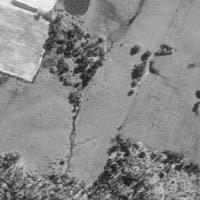
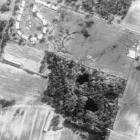
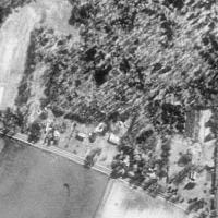
9 Soils Data: Soil analysis in the dry meadow revealed the following: DEPTH HORIZON MATRI REDO COMMENTS 0-10 A 10YR 5/3 silt loam 10+ AB 10 YR 4/3 30% 10Y 8/1 15% 5YR 6/8 Sketch approximate mitigation site, noting areas and types of wetlands, waters, other features, landscape position, landmarks, etc., and data and photo point(s) See file. Overall Description of site: This site consists of a large ponded area dominated by Typha latifolia and several smaller ponded sections with similar vegetation. These areas are 1-2 lower than surrounding upland and hold water. Some of the Scirpus validus and Sagittaria latifolia was larger than at any other site visited at heights of 7-8 and 3, respectively. Several of the cattail basins had duckweed in the water. Most of the vegetative diversity was at the edge of the cattail ponds. Each of the ponds was surrounded primarily by dry meadow, though there were pockets of wet meadow. Dry meadow vegetation consisted of Daucus carota, several grass species, and a Solidago sp., as well as the tree species noted under other plants. Comments, problems, recommendations: This site is out of compliance. The permit states that invasive plants need to be removed and this has not been done; they now dominate the site. The site is supposed to be an 8-acre forested wetland, but does not have the hydrology or the vegetation to fit this description. Monitoring reports have not been submitted for this mitigation site. Page 2 of 2
10
11
12
13
14
15
16 8.4 ac residential, forest POW, PEM yes no no 60% 100 feet Southern Auto Sales N RL PM W /14/03 yes 0 n/a clay substrate dense vegetation however little opportunity to perform function dense vegetation however little opportunity to perform function birds, frogs, butterflies, muskrats observed fenced off along road none known

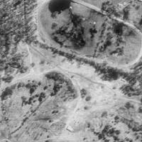
17 Southern Auto Sales East Windsor, CT 8/23/02 Looking southerly from the northern side of the site. The site ends at the treeline in the distance.

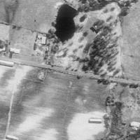
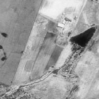
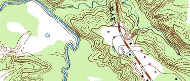
18 8 km NE of Windsor, Connecticut, United States 23 Apr 1990 Image courtesy of the U.S. Geological Survey 2003 Microsoft Corporation. All rights reserved.
Polpis Bike Path. General Impacts: 1.47 acres forested, marsh, shrub swamp
 Polpis Bike Path File No.: 199201570 City and State: Nantucket, MA General Impacts: 1.47 acres forested, marsh, shrub swamp Functions and Values Lost: (from EA/SOF) Floodflow Alteration Groundwater Discharge
Syfeld Keene Associates
 Syfeld Keene Associates File No.: 198100675 City and State: Keene, NH General Impacts: 9.8 acres PSS/PFO/PEM (permit states most of 13 acre site ) Functions and Values Lost: Floodflow alteration (only
ME DOT Route 3. File No.: City and State: Bar Harbor, ME
 ME DOT Route 3 File No.: 199600361 City and State: Bar Harbor, ME General Impacts: 0.28 acre tidal emergent 0.77 acre non-tidal forested 0.15 acre non-tidal emergent 0.51 acre non-tidal scrub-shrub Functions
Caler Cove Lobster Company
 File No.: 199800920 City and State: Addison, ME Caler Cove Lobster Company General Impacts: 0.17 acre tidal emergent Functions and Values Lost: Production Export Nutrient Exchange Sediment Filtration Fishery
EPA Surface Water Enhancement, Restoration & Protection (SWERP)
") EPA Surface Water Enhancement, Restoration & Protection (SWERP) Clearinghouse Application Form 4.0004 wirerp"776- )11644141' For assistance with completing this form, please refer to the SWERP Clearinghouse
EPA Surface Water Enhancement, Restoration & Protection (SWERP) Clearinghouse Application Form 4.0004 wirerp"776- )11644141' For assistance with completing this form, please refer to the SWERP Clearinghouse
Forest Preserves of Cook County Species Treatment List
 Woody Plants Common Name Scientific Name Treatment Options Treatment Season Tree of Heaven Alianthus altissima Basal bark application, use 20% Element 4 (better option) Cut and treat stems with a 20% Element
OPERATIONS & MAINTENANCE MANUAL FOR POST CONSTRUCTION MEASURES
 OPERATIONS & MAINTENANCE MANUAL FOR POST CONSTRUCTION MEASURES THE CARMONY BUILDING PARAGON REALTY NORTH GREEN STREET BROWNSBURG, HENDRICKS COUNTY INDIANA 8365 Keystone Crossing, Suite 201 Indianapolis,
2016 Vegetation Monitoring Report ERA Project # Prepared for: Downers Grove Park District
 Lyman Woods Streambank Stabilization Project Site Area II, Phase III Downers Grove, Illinois 2016 Vegetation Monitoring Report ERA Project #100301 Prepared for: Downers Grove Park District December 2016
Site 34 Bowman s Woods East General Description
 Table 34- Bowman s Woods East 34 Bowman s Woods East General Description This area is an extension of Bowman s Woods (West), north of Sherk Rd and east of Willoughby Drive. Boyer s Creek runs diagonally
Strategies for Control Based on Life Cycle of Invasive Plants
 Strategies for Control Based on Life Cycle of Invasive Plants Courtney LeClair Invasive Plant Specialist Wisconsin DNR Courtney.leclair@wisconsin.gov Weed Increase Over Time and Control Potential (1) (2)
Section 1 Woody Plants: Trees & Shrubs
 1 Section 1 Woody Plants: Trees & Shrubs Acer spp. Native trees Fruits of sugar maple (Acer saccharum) Fruits of red maple (Acer rubrum) Photos: Virginia Tech Dendrology Program Acer spp. Leaf comparison
Invasive Plant Inventory 21st Century Planting Design and Management Plan Mill and Judkins Ponds, Winchester Town Center
 Tree of Heaven, Ailanthus altissima Deciduous Tree Size: up to 80 feet Flowers: clusters of yellow-green flowers at the ends of upper branches Leaves: pinnately compound with 11-14 leaflets Fruit: seeds
Philbrook Avenue Wetlands and Stream Riparian Restoration Project Planting Plan 2009 REVISED AUGUST 24, 2009
 Philbrook Avenue Wetlands and Stream Riparian Restoration Project Planting Plan 2009 REVISED AUGUST 24, 2009 Submitted by Boyle Associates Per Request of Gorrill Palmer Consulting Engineers & the Cumberland
Mercer EducationalGardens. Meadow (3/4 acre)
") Mercer EducationalGardens Meadow (3/4 acre) Photo courtesy of Hopewell Township engineer June 2008 2007-2010 Wetland Meadow Restoration At Meadow Restoration Mercer Educational Gardens Meadow in 2007 Reed
Mercer EducationalGardens Meadow (3/4 acre) Photo courtesy of Hopewell Township engineer June 2008 2007-2010 Wetland Meadow Restoration At Meadow Restoration Mercer Educational Gardens Meadow in 2007 Reed
10 Years of Post-Construction Monitoring of Constructed Vernal Pools for the Stewart Airport Interconnector Roadway
 10 Years of Post-Construction Monitoring of Constructed Vernal Pools for the Stewart Airport Interconnector Roadway Justin Baker, PWS Dana Flynn, CWB PROJECT OVERVIEW 2 PROJECT OVERVIEW 2006 construction
memo Project Name Little Lake Point Intercept Survey 2017 Date 9/5/17 To / Contact info Jerry Spetzman Cc / Contact info Greg Graske, PE
 memo Project Name Little Lake Point Intercept Survey 2017 Date 9/5/17 To / Contact info Cc / Contact info From / Contact info Regarding Jerry Spetzman Greg Graske, PE Joe Pallardy, Mike Majeski Little
Riparian Planting Plan Requirements 21 October 2013
 Riparian Planting Plan Requirements 21 October 2013 a. Planting a riparian area with trees and shrubs evenly interspersed. The size of the riparian area must be at least 1:1 ratio with the amount of overwater
Wisconsin Dept. of Transportation November 2017
 Wisconsin Dept. of Transportation November 2017 Jennifer Gibson WisDOT Environmental Coordinator Mike Helmrick WisDOT Environmental Coordinator Background on compensatory wetland mitigation Site purpose
Lake Mansfield 2012 Aquatic Vegetation Survey
 Final Project Report: September 13, 2012 Lake Mansfield 2012 Aquatic Vegetation Survey ======== Prepared For: Town of Great Barrington Attn: Amanda Sewall, Conservation Agent Town Hall, 334 Main Street
Black swallowort vine in flower.
 Background The Marginal Way trail is being assaulted by an invasion of non-native shrubs and vines. A relatively new occurrence, black swallowort vine (Cynanchum louiseae), is spreading at an alarming
Spence Restoration Nursery
 Specifications for Installation of Wetland Plants in Stormwater Wetlands (According to Marion County, Indiana Regulations) Part 1 General 1.01 Section Includes A. Preparation B. Seeding C. Planting D.
STORMWATER MANAGEMENT CRITERIA APPENDIX D: STORMWATER MANAGEMENT POND DESIGN GUIDANCE D. i APPENDIX D 1 STORMWATER MANAGEMENT POND PLANTING GUIDELINES
 STORMWATER MANAGEMENT CRITERIA APPENDIX D: STORMWATER MANAGEMENT POND DESIGN GUIDANCE D. i APPENDIX D 1 STORMWATER MANAGEMENT POND PLANTING GUIDELINES CREDIT VALLEY CONSERVATION AUTHORITY July 2014 D.
Salix Coir Rolls. Building with Nature
 Salix Coir Rolls Building with Nature Description Salix produce a wide range of preestablished Coir Rolls planted with high quality native plant species. We plant our Coir Rolls at a high density and grow
North Carolina Sandhills Weed Management Area. Tracy Rush Program Coordinator
 North Carolina Sandhills Weed Management Area Tracy Rush Program Coordinator Weed Management Area Partnership of federal, state and local government agencies; conservation organizations; individuals and
Information for File # MMJ; Methodist Hospital Flood Storage Mitigation and Wetland Enhancement Project
 Information for File # 2016-01223-MMJ; Methodist Hospital Flood Storage Mitigation and Wetland Enhancement Project Applicant: Park Nicollet, Attn: Robert Riesselman Corps Contact: Melissa Jenny Address:
VIRGINIA BEACH TRANSIT EXTENSION STUDY
 Dra Environmental Impact Statement VIRGINIA BEACH TRANSIT EXTENSION STUDY Appendix M Iden fica on Technical Report February 2015 Cover image: courtesy of the City of Virginia Beach February 2015 TABLE
Response to Comments (July 28, 2010 Oregon City Determination of Application Completeness Memo)
") Environmental Science & Assessment, LLC MEMORANDUM DATE: August 13, 2010 TO: Oregon City Planning CC: Jill Long Lane Powell FROM: RE: Jack Dalton Response to Comments (July 28, 2010 Oregon City Determination
Environmental Science & Assessment, LLC MEMORANDUM DATE: August 13, 2010 TO: Oregon City Planning CC: Jill Long Lane Powell FROM: RE: Jack Dalton Response to Comments (July 28, 2010 Oregon City Determination
Riggs Brook Mitigation Site, Augusta
 MAINE DEPARTMENT OF TRANSPORTATION 2006 POST-CONSTRUCTION MONITORING REPORT: Riggs Brook Mitigation Site, Augusta (MDOT PIN 556.47) Year 3 of 5 Compensation for Augusta Third Bridge Project, Augusta (MDOT
Village of Willowbrook Landscaping Requirements
 Village of Willowbrook Landscaping Requirements PLANNING & DEVELOPMENT DEPARTMENT - VILLAGE OF WILLOWBROOK - Effective 4.14.17 01 02 03 04 05 General Landscaping Requirements... Section 9-14-2.23 Business
Separate roadways from commercial development by attractive landscape plantings
 INTRODUCTION Landscaping should be an integral part of all site plan developments. Trees, shrubs, and other landscape elements should be used to accentuate building design, create a sense of identity,
Preparing a Wetland Delineation Report
 Preparing a Wetland Delineation Report Why is the report important? In addition to documenting the wetland determination/delineation, the report often provides the basis for further regulatory permitting/compliance.
Section 1 TABLE OF CONTENTS
 Section 1 TABLE OF CONTENTS... [M]ineral fertilizer is essential to feed around half of the world s population, and will be fundamental to ensure global food security through the 21 st century. 2013 U.N.
Creating ponds for water voles
 Creating ponds for water voles A 50-YEAR PROJECT TO CREATE A NETWORK OF CLEAN WATER PONDS FOR FRESHWATER WILDLIFE 1. Introduction Water voles have suffered a catastrophic decline in Britain over the last
Stormwater Standards. Clackamas County Service District No. 1. Planting Guide for Buffers
 Stormwater Standards Clackamas County Service District No. 1 APPENDIX B Planting Guide for Buffers Table of Contents Appendix B - Planting Guide for Buffers... Page B.1 General... 1 B.1.1 Introduction...
las vegas wash coordination committee
 las vegas wash coordination committee lvwash.org DU Wetlands No. 1 Weir Planting Plan February 2013 DU Wetlands No. 1 Weir Planting Plan SOUTHERN NEVADA WATER AUTHORITY Las Vegas Wash Project Coordination
TOWNSHIP OF LOGAN SOIL & FILL IMPORTATION AND PLACEMENT APPLICATION SUBMITTAL CHECKLIST
 TOWNSHIP OF LOGAN SOIL & FILL IMPORTATION AND PLACEMENT APPLICATION SUBMITTAL CHECKLIST Applications: 5 copies of application - Applicant will reproduce the copies at his/her costs. The Township Clerk
Alternative Routes. St. Vital to La Verendrye Station - Southern Loop Transmission Corridor. 20 different segments 4 segments common to all routes
 Alternative Routes St. Vital to La Verendrye Station - Southern Loop Transmission Corridor In a fixed right-of-way St. Vital to Letellier Station 20 different segments 4 segments common to all routes Goal
PUBLIC NOTICE. us Anny Corps CENAE-R-A FILE NO. NAE
 CENAE-R-A FILE NO. NAE-2007-02926 PUBLIC NOTICE us Anny Corps of Engineers s. New England District 696 Virginia Road Concord, MA 01742-2751 Comment Period Begins: January 15, 2019 Comment Period Ends:
Invasive Plant Mapping in Stanley Park
 Submitted to: Alan Duncan, Vancouver Park Board Submitted by: Robyn Worcester and Greg Ferguson, Stanley Park Ecology Society Date: 24 January 2012 1 Table of Contents Project Background... 3 Project Summary...
City of Sun Prairie Wetland Buffer Reduction Request
 City of Sun Prairie Wetland Buffer Reduction Request Westside Development Area January 9, 2017 Prepared by: City of Sun Prairie 300 E. Main Street Sun Prairie, WI 53590 BACKGROUND The City of Sun Prairie
Section 3 Non-Structural BMPs
 3.1 Stream Buffers A stream buffer or stream setback is a designated area around a stream, lake, or wetland left in a natural, densely vegetated state so as to protect the receiving water quality and provide
Draft Rhode Island Stormwater Design and Installation Standards Manual
 Draft Rhode Island Stormwater Design and Installation Standards Manual Summary The May 2009 Public Review Draft version of the RI Stormwater Design and Installation Standards Manual consists of approximately
Brick Pond 7/16/04 5:00
 MN WHEP VEGETATION SURVEY FIELD SHEET: SITE INFORMATION Site Name: Team Leader/Observer: Robert Orleans Local Sponsor: Dakota Co. Date/Time: Team Name: Eagan County: Dakota Brick Pond 7/6/04 :00 Location
319 Grant: Baker Creek & Centenary Creek Restoration Initiative
 319 Grant: Baker Creek & Centenary Creek Restoration Initiative Objectives: Overview of Watershed Characteristics: Discussion of Project Tasks: Discussion of Watershed Management Plan: Presented by: Erich
APPENDIX 1: SCOPED ENVIRONMENTAL IMPACT STATEMENT (EIS) FORM
 FORM") APPENDIX 1: SCOPED ENVIRONMENTAL IMPACT STATEMENT (EIS) FORM This form is intended for use by applicants (primarily private landowners) who need to conduct a Scoped EIS in support of minor development
APPENDIX 1: SCOPED ENVIRONMENTAL IMPACT STATEMENT (EIS) FORM This form is intended for use by applicants (primarily private landowners) who need to conduct a Scoped EIS in support of minor development
Integrated Pest Management Program Department of Plant Science and Landscape Architecture UConn Extension
 Integrated Pest Management Program Department of Plant Science and Landscape Architecture UConn Extension Homegrown Beetles: Backyard Biocontrol Donna Ellis, Senior Extension Educator UConn Department
Morro Shoulderband Snail Protocol Survey Report for the Parcel at 3093 Beachcomber Drive, Morro Bay, San Luis Obispo County, California
 Morro Shoulderband Snail Protocol Survey Report for the Parcel at 3093 Beachcomber Drive, Morro Bay, San Luis Obispo County, California Prepared for: John K. Construction Inc. Prepared by: SWCA Environmental
Plants for Rain Gardens and Pond Edges
 Plants for Rain Gardens and Pond Edges Marina D Abreau UF-IFAS Hillsborough County Extension Florida Extension Master Gardener Continued Training Conference October 26, 2010, 1:45 pm Outline for Today
Natural Shorelines. for Inland Lakes. A Landowner s Guide to using. to STABLIZE SHORELINES, Michigan s inland lakeshore.
 Natural Shorelines for Inland Lakes A Landowner s Guide to using NATURAL MATERIALS to STABLIZE SHORELINES, IMPROVE WATER QUALITY and ENHANCE WILDLIFE HABITAT along Michigan s inland lakeshore. Natural
CHAPTER 2 SUMMARY 1. PROJECT SUMMARY DATA
 CHAPTER 2 SUMMARY This is an Initial Study format used to determine, pursuant to CEQA Guidelines Section 15177, whether a project 1) is within the scope of a Master EIR (MEIR), 2) may result in additional
ADDENDUM TO BIOLOGICAL SCOPING SURVEY REPORT, BOTANICAL SURVEY AND WETLAND DELINEATION
 ADDENDUM TO BIOLOGICAL SCOPING SURVEY REPORT, BOTANICAL SURVEY AND WETLAND DELINEATION FOR AVALON INN (APN 069-241-27 & -04) 1201 & 1211 NORTH MAIN STREET FORT BRAGG, CA MENDOCINO COUNTY prepared for:
ENBRIDGE GAS DISTRIBUTION INC. Proposed Relocation for Ninth Line, Markham and Whitchurch-Stouffville. Environmental Screening Report
 Page 1 of 18 ENBRIDGE GAS DISTRIBUTION INC. Proposed Relocation for Ninth Line, Markham and Whitchurch-Stouffville Environmental Screening Report July 2011 Page 2 of 18 Table of Contents 1.0 INTRODUCTION
Mill Conversion Overlay District Zoning Bylaw Amendment
 Mill Conversion Overlay District Zoning Bylaw Amendment To see if the Town will vote to amend the Zoning By-Law by adding a new Section 13, Mill Conversion Overlay District, and by amending Sections 2.1,
MEMORANDUM OF BOG TURTLE HABITAT INVESTIGATION
 MEMORANDUM OF BOG TURTLE HABITAT INVESTIGATION 410-728-2900 Fax: 410-728-3160 www.rkk.com To: From: CC: U.S. Fish and Wildlife Service, Pennsylvania Fish and Boat Commission Jennifer A Ottenberg Miller,
BLACK CREEK VALLEY CONNECTION SIGNIFICANT WETLAND CONNECTION PROPOSED OFFSITE NATURAL AREAS MANAGEMENT STRATEGY BLACK CREEK WATERSHED
 BLACK CREEK VALLEY V:\01609\active\2001 Active Projects\1100-1199\G1188\graphics\GIS\MXD\_Final Draft Sept 2008\MXD\Section_7\62601188_Fig7-1_ProposedNaturalAreasMngmtStrategyBCWSNorth_28Nov08_MC.mxd HIGHWAY
Northern Branch Corridor SDEIS March 2017
 Northern Branch Corridor SDEIS March 2017 15. 15.1. Chapter Overview 15.1.1. Introduction This chapter discusses changes to the Preferred Alternative resulting in the potential for project improvements
Minnesota Department of Natural Resource - Natural Resource Guidance Checklist Conserving Natural Resources through Density Bonuses
 Minnesota Department of Natural Resource - Natural Resource Guidance Checklist Conserving Natural Resources through Density Bonuses NRDB Why Use Density Bonuses & This Checklist Local units of government
Heron Glen Wetland Buffer Enhancement Project. Progress Report. August 10, 2004 (resent October 19, 2004)
") Heron Glen Wetland Buffer Enhancement Project Progress Report August 10, 2004 (resent October 19, 2004) Summary of Activity Since Last Report (July 2003) Weed Control Himalayan blackberry (Rubus discolor)
Heron Glen Wetland Buffer Enhancement Project Progress Report August 10, 2004 (resent October 19, 2004) Summary of Activity Since Last Report (July 2003) Weed Control Himalayan blackberry (Rubus discolor)
Article 6 Tree Protection
 Article 6 Tree Protection 8.1 Purpose 8.2 Applicability 8.2.1 General Provisions 8.2.2 Exemptions 8.3 Permitting Procedure 8.4 Planting Procedure 8.5 Performance Guarantee Required for Belated Planting
O F T H E M O N A D N O C K R E G I O N I D E N T I F I C A T I O N & C O N T R O L
 PULLING TOGETHER INVASIVE PLANTS OF THE MONADNOCK REGION IDENTIFIC ATION & CONTROL Burning buckthorn Cutting knotweed Schoolyard garlic mustard Backyard garlic mustard Whacking buckthorn College campus
Turning your Dam into habitat. By Damien Cook
 Turning your Dam into habitat By Damien Cook Depending on their particular habitat needs wetland animals will be found in different habitats within a wetland, from damp margins to deeper water. An important
Chapter 4 - Preparation of Stormwater Site Plans
 Chapter 4 - Preparation of Stormwater Site Plans The Stormwater Site Plan is the comprehensive report containing all of the technical information and analysis necessary for the City to evaluate a proposed
John B. Taft Connie Carroll-Cunningham Hannah L. Grant. INHS Technical Report 2014 (05)
") Year 213 Results and Trends Analysis from Vegetation Monitoring in 2 Constructed Bioswales along Interstate 294, Touhy Avenue to Lake-Cook Road, Cook County, IL John B. Taft Connie Carroll-Cunningham Hannah
Year 213 Results and Trends Analysis from Vegetation Monitoring in 2 Constructed Bioswales along Interstate 294, Touhy Avenue to Lake-Cook Road, Cook County, IL John B. Taft Connie Carroll-Cunningham Hannah
Appendix I. Checklists
 Appendix I Checklists Town of Greenwich Drainage Manual Department of Public Works - Engineering Division Town Hall - 101 Field Point Road, Greenwich, CT 06836-2540 Phone 203-622-7767 - Fax 203-622-7747
Natural Areas Certification Program Guidelines
 Natural Areas Certification Program Guidelines Purpose of the Program The City of Fort Collins Natural Areas Department encourages site management practices that focus on protecting, restoring, and enhancing
The Maryland-National Capital Park and Planning Commission Prince George's County Planning Department Development Review Division
 The Maryland-National Capital Park and Planning Commission Prince George's County Planning Department Development Review Division 301-952-3530 Note: Staff reports can be accessed at www.mncppc.org/pgco/planning/plan.htm.
Zoning Ordinance Article 3
 Article 3 Natural Resources Protection Section 301 Natural Resources Protection 301.1. Purpose - The following natural resources protection standards are established to protect the public health, safety
Non-Metallic Mining Reclamation Checklist
 Eau Claire County DEPARTMENT OF PLANNING AND DEVELOPMENT Eau Claire County Courthouse, Rm. 1510 721 Oxford Avenue Eau Claire, Wisconsin 54703-5481 (715) 839-4741 f Housing & Community Development 839-6240
Town of Windham. Planning Department 8 School Road Windham, ME voice fax
 Town of Windham Planning Department 8 School Road Windham, ME 04062 voice 207.864-5960 fax 207.892.1916 MEMO DATE: TO: Staff Review Committee FROM: Amanda Lessard, Planner Cc: Ellen Rathbone, St. Germain
Brandon J. Bushen 1 ABSTRACT
 Report on the 6 th year of monitoring vegetative succession along the Volney-Marcy South power line right of way in Greenwoods Conservancy, summer 2004 Brandon J. Bushen 1 ABSTRACT This report summarizes
Rule D Wetland and Creek Buffers
 Rule D Wetland and Creek Buffers 1 Policy It is the policy of the Board of Managers to ensure the preservation of the natural resources, recreational, habitat, water treatment and water storage functions
Grave Creek Riparian Revegetation 2011 Implementation Report
 Task Order #1008 Grave Creek Riparian Revegetation 2011 Implementation Report Prepared for: Kootenai River Network P.O. Box 491 Libby, MT 59923 Prepared by: Geum Environmental Consulting, Inc. 307 State
memo Project Name Spider Lake Point Intercept Survey 2017 Date 9/5/17 To / Contact info Jerry Spetzman Cc / Contact info Greg Graske, PE
 memo Project Name Spider Lake Point Intercept Survey 2017 Date 9/5/17 To / Contact info Cc / Contact info From / Contact info Regarding Jerry Spetzman Greg Graske, PE Joe Pallardy, Mike Majeski Spider
TRCA Field Staking Protocol December 2016
 Page 1 of 6 TRCA Field Staking Protocol December 2016 This Protocol describes TRCA staff s current practice for field staking the physical top of bank, the physical toe of slope, and the limit of existing
SPECIFIC PLAN Requirements
 CITY OF LANCASTER PLANNING DEPARTMENT 44933 Fern Avenue, Lancaster, California 93534 (661) 723-6100 SPECIFIC PLAN Requirements Purpose The purpose of a specific plan is to provide for the logical development
Stormwater Management/Bioswale Design. A Forest Preserve District of Cook County/Illinois Tollway Cooperative Solution
 Stormwater Management/Bioswale Design A Forest Preserve District of Cook County/Illinois Tollway Cooperative Solution Today s Challenge: Implement Stormwater BMPs for linear projects, i.e. roads and streets
PCE PRELIMINARY DRAINAGE ANALYSIS REPORT FOR WESTWOOD MIXED USE NEIGHBORHOOD PROJECT 772 NORTH FOREST ROAD TOWN OF AMHERST, ERIE COUNTY, NEW YORK
 PCE PRELIMINARY DRAINAGE ANALYSIS REPORT FOR WESTWOOD MIXED USE NEIGHBORHOOD PROJECT 772 NORTH FOREST ROAD TOWN OF AMHERST, ERIE COUNTY, NEW YORK MAY 19, 2014 Prepared By: Timothy M. Lavocat, P.E., CFM
Note: Staff reports can be accessed at Zone: I-3. Tier:
 The Maryland-National Capital Park and Planning Commission Prince George s County Planning Department Development Review Division 301-952-3530 Note: Staff reports can be accessed at www.mncppc.org/pgco/planning/plan.htm.
Florida s Ephemeral Ponds and Pond-Breeding Amphibians
 Florida s Ephemeral Ponds and Pond-Breeding Amphibians What are Ephemeral Ponds? Ephemeral ponds are small, isolated wetlands that dry periodically. These ponds can be deep, sand-bottomed depressions with
March 31, PENNDOT District Geerdes Road King of Prussia, PA Attn: Mr. Lawrence J. Link, P.E. Dear Mr. Link:
 March 31, 2002 PENNDOT District 6-0 7000 Geerdes Road King of Prussia, PA 17406 Attn: Mr. Lawrence J. Link, P.E. Re: S.R. 4005 and 4007, Sections 15P & 15B Germantown Avenue Reconstruction Project Letter
North Central Conservation District
 North Central Conservation District Annual Report Fiscal Year 2015-2016 2016 www.conservect.org/northcentral North Central Conservation District Introduction This Annual Report summarizes work performed
Information for File # MHK
 Information for File #2014-03555-MHK Applicant: Corps Contact: Wimmer Communities Marie Kopka Address: 250 N. Sunnyslope Road, Suite 296 Brookfield, Wisconsin 53005 E-Mail: Marie.H.Kopka@usace.army.mil
Green Design Principles
 Green Design Principles restoration planting Ecosystem restoration, including preserving and enhancing existing vegetation and where feasible, introducing new vegetative communities, benefits the stream
Procedures IV. V. Rural Road Design Option
 i IV. Procedures A. All applicants required to prepare a Conservation Design Subdivision shall provide the Planning Board with a conceptual conventional subdivision design as well as a proposed layout
( THE M4 CORRIDOR AROUND NEWPORT )
") PUBLIC INQUIRY IN THE MATTER OF THE HIGHWAYS ACT 1980 AND THE ACQUISITION OF LAND ACT 1981 AND IN THE MATTER OF: THE M4 MOTORWAY (JUNCTION 23 (EAST OF MAGOR) TO WEST OF JUNCTION 29 (CASTLETON) AND CONNECTING
PUBLIC INQUIRY IN THE MATTER OF THE HIGHWAYS ACT 1980 AND THE ACQUISITION OF LAND ACT 1981 AND IN THE MATTER OF: THE M4 MOTORWAY (JUNCTION 23 (EAST OF MAGOR) TO WEST OF JUNCTION 29 (CASTLETON) AND CONNECTING
Saugus River Watershed Invasive Aquatic Vegetation Assessment
 Saugus River Watershed Invasive Aquatic Vegetation Assessment ================================== DECEMBER 2008 Prepared For: Saugus River Watershed Council c/o Joan LeBlanc, Executive Director P.O. Box
Major Subdivision Sketch Plan Checklist
 This checklist provides specific requirements that are apart of the Sketch process. The entire process is described by the Huntersville Subdivision Review Process which details all the submittal and resubmittal
APPENDIX C NATURAL RESOURCES MANAGEMENT PLAN: ACTIONS AND PRIORITIES
 APPENDIX C NATURAL RESOURCES MANAGEMENT PLAN: ACTIONS AND PRIORITIES TABLE C-1: Resource Actions and Priorities GOAL NRM-4 Objective 4.1: Restore Natural floodplain functions. Objective 4.2: Define and
Healthy Living Strategy: Shorelines
 Healthy Living Strategy: Shorelines Shoreline Vegetation in Muskoka The basis of a natural ecosystem is a complex combination of vegetation that forms canopy, understory, and herbaceous layers. It is easier
Coquitlam River Riparian Planting
 Coquitlam River Riparian Planting Year Four Year Four Report, March 2016 Prepared for: Fish and Wildlife Compensation Program Prepared by: Watershed Watch Salmon Society and the Kwikwetlem First Nation
Environmental Protection Ordinances (Performance Zoning) Bedminster Township, Bucks County
 Bedminster Township, Bucks County") Environmental Protection Ordinances (Performance Zoning) Bedminster Township, Bucks County ARTICLE VI. PERFORMANCE STANDARDS Section 600 Compliance All uses, activities, subdivisions and/or land developments
Environmental Protection Ordinances (Performance Zoning) Bedminster Township, Bucks County ARTICLE VI. PERFORMANCE STANDARDS Section 600 Compliance All uses, activities, subdivisions and/or land developments
UTT/17/2075/FUL - (BERDEN) (Referred to Committee by Councillor Janice Loughlin. Reason: In the Public Interest)
 (Referred to Committee by Councillor Janice Loughlin. Reason: In the Public Interest)") UTT/17/2075/FUL - (BERDEN) (Referred to Committee by Councillor Janice Loughlin. Reason: In the Public Interest) PROPOSAL: LOCATION: APPLICANT: Amendments to the design of a scheme for a 49.99MW battery
UTT/17/2075/FUL - (BERDEN) (Referred to Committee by Councillor Janice Loughlin. Reason: In the Public Interest) PROPOSAL: LOCATION: APPLICANT: Amendments to the design of a scheme for a 49.99MW battery
Invasive plants in cities: A historical perspective based on the flora of Indianapolis
 Invasive plants in cities: A historical perspective based on the flora of Indianapolis Rebecca W. Dolan Friesner Herbarium and Center for Urban Ecology, Butler University Result of search on urban using
DRIVEWAY LOCATION APPROVAL RULES AND REGULATIONS
 TOWN OF SUDBURY DRIVEWAY LOCATION APPROVAL RULES AND REGULATIONS 1. Driveway Location Approval Application Procedure 2. Form of Application 3. Form of Driveway Location Plan 4. Consideration by Town Engineer
Lake Nokomis Shoreline Enhancement Project
 Lake Nokomis Shoreline Enhancement Project Community Meeting 2 February 13, 2018 Agenda Current Problems Project Goals Project Status Existing Conditions Community Input Draft Schematic Design Long-term
Naturalized Stormwater Management Facility
 Naturalized Stormwater Management Facility Design, Planting and Management Plan Guidelines Village of Montgomery, Illinois Prepared by: Planning Resources Inc. 402 West Liberty Drive Wheaton, Illinois
R E S O L U T I O N. Designation: Section 2, Block 17, Lot 20.G-1 ( ) R-2A (1-Family, 2-acre Minimum Lot Size) 46 North Greenwich Road
 R-2A (1-Family, 2-acre Minimum Lot Size) 46 North Greenwich Road") PLANNING BOARD Arthur Adelman, Chair TOWN OF NORTH CASTLE WESTCHESTER COUNTY 17 Bedford Road Armonk, New York 10504-1898 R E S O L U T I O N Telephone: (914) 273-3542 Fax: (914) 273-3554 www.northcastleny.com
PLANNING BOARD Arthur Adelman, Chair TOWN OF NORTH CASTLE WESTCHESTER COUNTY 17 Bedford Road Armonk, New York 10504-1898 R E S O L U T I O N Telephone: (914) 273-3542 Fax: (914) 273-3554 www.northcastleny.com
Chesapeake Bay Critical Area Conservation Plan
 The Maryland-National Capital Park and Planning Commission Prince George s County Planning Department Development Review Division 301-952-3530 Note: Staff reports can be accessed at www.mncppc.org/pgco/planning/plan.htm.
Module 1 ~ Silent Invaders (MS/HS) Emersed Plants Reading Activity
 Emersed Plants Reading Activity") Name: Class Period: Date: Directions: Read the passage and use the information you ve learned to answer the questions below using complete sentences. Emersed plants are rooted in shallow water with much
Name: Class Period: Date: Directions: Read the passage and use the information you ve learned to answer the questions below using complete sentences. Emersed plants are rooted in shallow water with much
Variance Staff Report St. Croix County Board of Adjustment Ben Hanke / Calda Donna LLC Hearing Date: January 20 & 21, 2016
 Applicant: Agent: Calda Donna LLC / Ben Hanke Bruce Lenzen Site Address: Salishan Drive Government Lots 1 and 2 Parcel ID #: 040-1146-40-000 Computer #: Site Location: Zoning District: Site Size: Requests: