Riggs Brook Mitigation Site, Augusta
|
|
|
- Madeline Robinson
- 6 years ago
- Views:
Transcription
1 MAINE DEPARTMENT OF TRANSPORTATION 2006 POST-CONSTRUCTION MONITORING REPORT: Riggs Brook Mitigation Site, Augusta (MDOT PIN ) Year 3 of 5 Compensation for Augusta Third Bridge Project, Augusta (MDOT PIN ) ACOE Permit Number: MDEP Permit Number: L E-C-M March 2007 Prepared By MAINE DEPARTMENT OF TRANSPORTATION Environmental Office Field Studies and Mitigation Division 16 State House Station Augusta, Maine 04333
2 Post-Construction Monitoring Report: 2006 Riggs Brook Site, Augusta (PIN ) 2006 Post Construction Monitoring Report: Riggs Brook Site, Augusta (PIN ) CONTENTS Section Title Page 1.0 PROJECT BACKGROUND PERFORMANCE STANDARD QUESTIONS NARRATIVE DISCUSSION 3.1 Monitoring Inspections Remedial Activities in Plant Survival and Condition Wildlife Use of the Site Other Observations REMEDIAL MEASURES FOR FUTURE MONITORING REPORTS 11 Appendices: Appendix A. MDEP and Corps Permits Appendix B. As-Built Plan Appendix C. Photographs List of Tables: Table 1. Summary Table - Site Progress Toward Performance Standards 1 Table 2. Summary of Existing and Proposed Upland Density Standards 7 Table 3. Summary of Existing and Proposed Wetland Density Standard 7 List of Figures: Figure 1. Location Map Riggs Brook Site 2 i
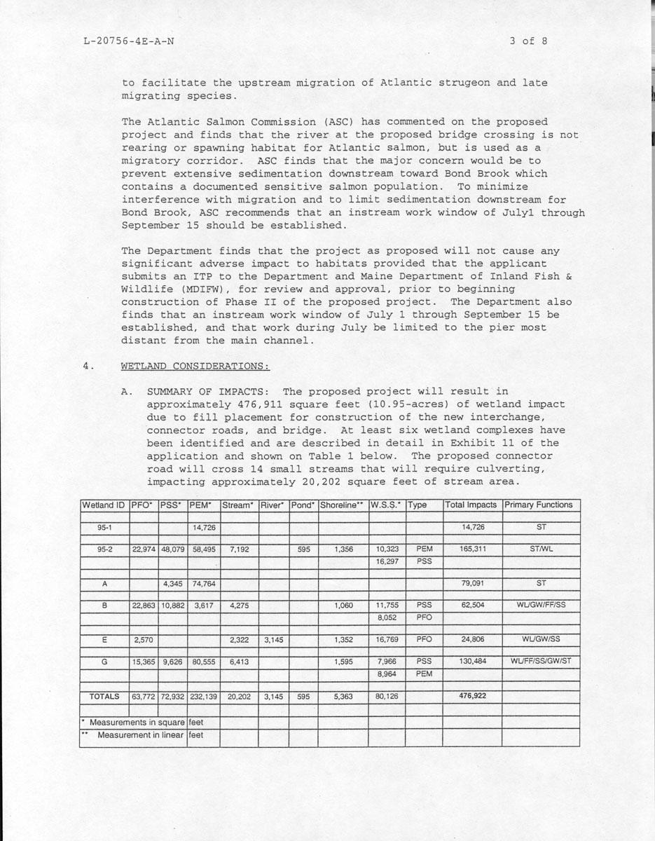
3 Post-Construction Monitoring Report: 2006 Riggs Brook Site, Augusta (PIN ) 1.0 PROJECT BACKGROUND This report presents the results of the third year (2006 growing season) of the five-year postconstruction monitoring period at the Riggs Brook mitigation site in Augusta, Kennebec County (Figure 1). The site provides partial compensation for the acres of impacts to wetlands and streams associated with the construction of the Augusta Third Bridge project by the Maine Department of Transportation (MaineDOT) as described in the Wetland Mitigation Plan (the Plan) for the project dated December Compensation at the site consisted of the enhancement of selected areas of the riparian zone within a 24.5 ± acre site along Riggs Brook. This report is being submitted to comply with the conditions contained in the permits received in 2002 from the Maine Department of Environmental Protection (MDEP) (permit number L E-A-N), and from the U.S. Army Corps of Engineers (Corps), (permit number ) for PIN (Appendix A). Monitoring at the Riggs Brook site consists of tracking the establishment of planted stock and volunteer species within the enhanced wetland areas at the site and relating the results to the required performance standards. Table 1 summarizes the conditions at the site end of the third growing season (2006) and compares them with the performance standards. Table 1. Summary Table Showing Site Progress Towards Performance Standards Performance Standard 2004 Findings (Year 1) 2005 Findings (Year 2) 2006 Findings (Year 3) Met Standard? Livestock Exclusion Perimeter fencing installed Fencing intact Fencing intact Yes Stable slopes with no significant erosion Soils stable and well vegetated Soils stable and well vegetated Soils stable and well vegetated Yes Minimum prescribed plant density in each treatment zone High mortality due to flooding in two zones; replacement plantings installed 1 Replacement plantings installed, planting density met in 1 of 3 planting zones Planting density low in 3 planting zones Too early 1 in accordance with Corps guidelines, some plantings were shifted away from Riggs Brook in response to the extensive flooding that occurred at the site during the winter of
 Figure 1.")
4 Post-Construction Monitoring Report: 2006 Riggs Brook Site, Augusta (PIN ) Figure 1. Riggs Brook Site Location Map Riggs Brook Site Third Bridge Project - 2 -
5 Post-Construction Monitoring Report: 2006 Riggs Brook Site, Augusta (PIN ) 2.0 PERFORMANCE STANDARD QUESTIONS The goal of the enhancement at the Riggs Brook site specified in the Plan is to offset the loss of wetland functions and values resulting from the construction of the Augusta Third Bridge project. To achieve this goal, factors that previously impaired the wetland functions and values within the Riggs Brook site were addressed by excluding livestock from the riparian corridor, repairing and stabilizing individual areas of bank erosion, and re-establishing trees and shrubs within selected wetland and adjacent upland areas of the riparian zone previously degraded by agricultural activities. The monitoring plan for the site calls for documenting the successful exclusion of livestock from the site, evaluating the stability of eroded areas, assessing the survival of planted shrubs and trees, and comparing the results to specified performance standards. In accordance with the Plan, the enhancement effort is required to meet the following performance standards by the end of the monitoring period: Livestock Exclusion: Has livestock been excluded from the site? Yes. The perimeter fence and the mitigation area boundary signs previously installed along the perimeter were found to be intact and functioning as intended. Livestock grazing on adjacent land has been discontinued. Soil Stabilization: Are slopes within the mitigation area stable? Yes. Previously seeded areas were stable and herbaceous cover was well established in these areas. Planting Density: Do the planting zones at the mitigation site meet the minimum density requirements? No. The three planting zones at the site are 1) the Wetland Streamside zone, 2) the Wetland Tree and Shrub zone, and 3) the Upland Tree and Shrub zone. The tree and shrub density in the Streamside, Wetland, and Upland zones did not meet the minimum density requirements for each zone. The conditions noted in 2006 are described in more detail in Section
6 Post-Construction Monitoring Report: 2006 Riggs Brook Site, Augusta (PIN ) Invasive Species: a) Is common reed (Phragmites sp.) or purple loosestrife (Lythrum salicaria) at the mitigation site being controlled? Common reed and purple loosestrife were not found within the enhancement area and were not noted in the vicinity of the site. b) Has the experimental control of reed-canary grass been implemented? Yes. As noted during the initial evaluation of the site, reed canary grass is well-established within the floodplain of Riggs Brook. While this species was expected to persist, the streamside and wetland zone plantings were intended to eventually limit the spread of grass through shading and to allow woody vegetation to gain a foothold in the streamside areas. Some wattles from the initial planting showed evidence of sprouting and growth. A number of supplemental willow wattles and live stakes placed in selected areas within the floodplain and in adjacent transitional areas in 2005 exhibited growth. The conditions noted in 2006 are described in more detail in Section NARRATIVE DISCUSSION 3.1 Monitoring inspections MaineDOT staff visited the site in April, May, June and September 2006 to check overall site conditions, assess the survival of plantings in need of replacement, and to evaluate the overall progress of the site toward meeting the performance standards. In the spring, the condition of planted trees and shrubs in each of the treatment zones was checked and plant survival was tallied. Soils in the repaired bank areas were checked to verify that they remained stable and that vegetation continued to become established as intended. In addition, signs of wildlife use, physical damage or disturbance, and the presence of invasive species were noted during site visits. In September, MaineDOT met with staff from the DEP and the Corps to review the overall condition of site and discuss potential replanting options. 3.2 Remedial Activities in 2006 No repairs, additional seeding, or replacement plantings were made at the site during the 2006 growing season
7 Post-Construction Monitoring Report: 2006 Riggs Brook Site, Augusta (PIN ) 3.3 Plant Survival and Condition Wetland Streamside Groups Water levels in Riggs Brook varied widely in the spring of 2006 in response to local rainfall. The streamside groups were subject to extended periods of flooding as noted in previous years that resulted in additional damage to the planted trees and shrubs from flooding, entrained plant material, ice movement, and wildlife. The alder and willow shrubs and live stakes suffered damage from beaver which were able to reach the groups relatively easily because of the high water levels. A number of the willow and elderberry plantings had resprouted despite repeated browse by beaver or damage from ice and flooding. The May and June assessments of the streamside planting groups indicated that the average woody plant density in this zone continues to fall below the performance standard. The number of live woody plants within all seven groups was tallied to determine a density for the 2.5 acre wetland planting zone. The total number of surviving trees and shrubs in the groups was approximately 419 plants. This equates to an average density of 167 plants per acre. This density is about 50% of the standard of 340 woody plants per acre proposed for this zone in the mitigation plan. Additional supplemental planting in a location less susceptible to damage from flooding will probably be required in order to reach the performance standard for this zone within the 5-year monitoring period and will be addressed as part of the remedial plan for the site in Wetland Tree and Shrub Plant Groups The wetland groups closest to Riggs Brook were subjected to flooding and ice movement over the winter and during the spring of 2006 resulting in damage to the planted trees and shrubs similar to the streamside groups. Damage from beaver to scattered plants in some of the wetland groups located closest to the stream was noted in May and September. Speckled alder and willow were browsed the most heavily. Flooded or saturated conditions also occurred in locations where small seeps and drainage swales intersected plant groups in the middle and upper portions of the site. In most of the wetland groups, however, plants were affected more by herbaceous competition than flooding
8 Post-Construction Monitoring Report: 2006 Riggs Brook Site, Augusta (PIN ) The May and June assessments of the wetland groups indicate that the average woody plant density in the Wetland Tree and Shrub zone was slightly less than the performance standards. The number of live trees and shrubs within all of the 42 plant groups in this zone was tallied to determine a density for the 6.5 acre wetland planting zone. A total of 223 trees were tallied. This results in an average density of 34 trees per acre, which is less than the standard of 45 trees per acre. The total number of shrubs tallied was 324 yielding an average shrub density of 50 per acre, falling below the standard of 60 shrubs per acre. This deficiency will be addressed as part of the remedial plan for the site in In addition, a proposed change in the performance standard for this zone is discussed in the following section. Upland Tree and Shrub Plant Groups The upland groups occur singly or in small clusters along knolls or in open field areas of the site and are intended to serve as starting points for the establishment of trees and shrubs in the future. Assessment of the upland groups in May and June showed that the average woody plant density was slightly less than the planted density and did not meet the performance standards. The number of live plants within all of the 39 upland groups was tallied to determine a preliminary density for the 14 acre planting zone. A total of 169 trees and shrubs were tallied. The tree density in the upland groups was approximately 8 trees per acre. The shrub density in the sampled groups was approximately 4 shrubs per acre. These densities are well below the density of 13 trees per acre and 17 shrubs per acre proposed in the mitigation plan. As first noted in the 2005 monitoring report, however, during final design the total number of trees and shrubs planted in the upland groups was reduced by about 160 plants. These plants were shifted to the wetland zone in order to boost the planting density in the wetland groups. This change was made to improve the ability of the woody plantings in the wetland zone to compete with the well established herbaceous vegetation. Despite this change, the total number of plants actually planted at the site slightly exceeded the number originally proposed in the Plan. The actual initial planting density in the upland zone was 11 trees per acre and 8 shrubs per acre. Given this change, MaineDOT proposed in the 2005 report to revise the density standards within the upland zone from those proposed in the mitigation plan to 9 per acre for trees and 7 per acre for - 6 -
9 Post-Construction Monitoring Report: 2006 Riggs Brook Site, Augusta (PIN ) shrubs. The proposed densities are 85% of actual planted densities and are in keeping with the anticipated survival rate used to calculate the original standards proposed in the mitigation plan. These changes are summarized in Table 2. The 2006 results fall slightly below the proposed revised standard and this deficiency will be addressed as part of the remedial plan for the site in Table 2. Existing and Proposed Planting Densities within the Upland Zone Trees Shrubs Density Standard Proposed in Mitigation Plan (±85% of planted density) 13/acre 17/acre Actual Planting Density 11/acre 8/acre Proposed Revised Density Standard (±85% of planted density) 9/acre 7/acre 2006 Results 8/acre 4/acre Given that approximately 160 plants were shifted to the wetland groups at the time of initial planting MaineDOT proposes to revise upward the performance standard for the wetland groups to reflect this change and to offset the decrease in the standard for the upland groups. The proposed revised standards for the wetland plant groups are as follows: Table 3. Existing and Proposed Planting Densities within the Wetland Zone Trees Shrubs Density Standard Proposed in Mitigation Plan (±85% of planted density) Proposed Revised Density Standard (±85% of planted density) 45/acre 54/acre 60/acre 72/acre 2006 Results 34/acre 50/acre - 7 -
10 Post-Construction Monitoring Report: 2006 Riggs Brook Site, Augusta (PIN ) Wattle Treatment Area In May, survivorship within the wattle and live stake planting areas was assessed and tallied. Within the initial wattle planting area located in the reed canary grass dominated floodway of Riggs Brook, evidence of sprouting and growth was found in 16 of the original 35 rows. The growth was limited, however, to small scattered clumps of willow sprouts at the upper end of the wattle rows. The upper ends of the rows are slightly higher in elevation and are generally subject to less frequent and prolonged flooding. Within the area near streamside group #7 where a number of replacement wattles and live stakes were installed in 2005, over 50% of the wattle bundles (26 out of 48) had signs of growth, and approximately 23% of the bundles (11 out of 48) had fair to good growth of willow sprouts along the row (defined as greater than 4 willow sprouts per bundle). Many of the live stakes were obscured by the herbaceous vegetation and were difficult to locate. However, the estimated live stake survival in this area appeared to be very poor probably due to prolonged saturation of the fine textured soils and herbivory. In the bank stabilization and drainage swale areas on the west side of Riggs Brook near plant groups 6F and 7F, approximately 50% of the wattles (16 out of 31) had growth, and approximately 23% of the wattles (7 out of 31) had fair to good growth of willow sprouts along the row. Sprouts on several of the most productive wattles in this area were over 3 feet tall in late spring. Based on a visual inspection of the live stakes installed in this area, it appears that approximately 33% (22 of 66 located) had survived and had put on new growth. 3.4 Wildlife Use of the Site Numerous wildlife species, sign and tracks were noted during visits to the site in 2006 including: deer (tracks), northern oriole, wild turkey, American robin, red-winged blackbird, American crow, white throated sparrow, barn swallow, bank swallow, bob-o-link, yellow warbler, common yellowthroat, bull frog, green frog, and a number of aquatic insects
11 Post-Construction Monitoring Report: 2006 Riggs Brook Site, Augusta (PIN ) 3.5 Other Observations As previously noted in 2005, beaver damage to a number of the plantings continued. The damage was greatest to the planted shrubs and live stakes in portions of the streamside and lower wetland plant groups. Willow and alder appeared to be the preferred target. Despite the damage, many of the willows and alders had resprouted, however the repeated browsing has generally limited the growth of the shrubs in this planting zone to a height of 12 to 15 inches. Browsing by beaver is likely to continue unless intensive measures to protect the planted trees and shrubs are implemented. The branching form and widely spaced distribution of the shrubs makes it impractical to protect the plants using either individual plant protectors or fencing thereby leaving them exposed to additional damage from beaver. Plant protectors are suitable for use on small trees, but are susceptible to damage from ice, high flows, and entrained plant material in areas near Riggs Brook. Based on the September 2006 site visit, the Corps site review report (dated December 2006) recommended trapping beaver at the site as a means to limit future damage to the plantings. MaineDOT conferred with the Maine Department of Inland Fisheries and Wildlife (IF&W) Regional Biologist regarding potential control options such as capture and release offsite or trapping. IF&W explained that lethal measures would probably be necessary, and that any beaver removed from within the site would likely be replaced by new recruits moving into the site from either upstream or downstream areas. Therefore, repeated control measures will likely be necessary to minimize beaver damage to plantings within the site. Other than scattered trash blown into the site from developed areas downstream along Route 3, no damage or disturbance from human activity was noted within the site. 4.0 REMEDIAL MEASURES FOR 2007 In response to the Corps site review report, dated December 2006, MaineDOT plans to implement remedial measures during 2007 in a good-faith effort to increase the likelihood that the Riggs Brook site will achieve the mitigation goals and performance standards by the end of the five year monitoring period. These measures are in addition to the remedial measures implemented in 2004 and 2005 and reported previously. The measures proposed for 2007 will be implemented to the - 9 -
12 Post-Construction Monitoring Report: 2006 Riggs Brook Site, Augusta (PIN ) greatest extent practicable given limited project funding and are expected to use up the remaining remedial budget. Given current and anticipated MaineDOT budget constraints, funding for additional remedial work at the Riggs Brook site will not be available. As a result, MaineDOT anticipates that this will be the final remedial effort at the Riggs Brook site. The following remedial measures are proposed: Reassess the condition of the streamside, wetland, and upland planting groups after bud break in the spring of 2007 to check for damage from flooding or beaver and confirm the number of plants that are alive or are likely to resprout. Coordinate with the IF&W Regional Biologist regarding the control of nuisance beaver within the site through measures such as trapping, in order to reduce the risk of damage to existing and proposed replacement plantings. The installation of replacement plantings within the streamside and lowermost wetland groups (described below) is contingent upon the successful implementation of the beaver control measures. If the risk of damage to plantings from beaver remains high, MaineDOT will confer with the DEP and the Corps regarding the need for additional planting in the streamside and lower wetland zone. Replace dead plantings within the streamside planting groups with additional native shrubs as needed to boost the woody plant density to the required standard. Depending on availability the plantings will likely consist of a mix of small (12 to15 inch) containerized shrubs and tubelings of willow (Salix discolor, S. lucida, S. sericea), dogwood (Cornus amomum), arrowwood (Viburnum dentatum) and elderberry and a limited number of wetland trees (3 to 4 feet), such as green and black ash (Fraxinus nigra), silver maple, and black willow. Planting of alder will depend on confirmation of the availability of native alder (Alnus incana ssp. rugosa) from the landscape contractor s supplier. In accordance with the Corps recommendations, the replacement plantings for each streamside group will be relocated to a position above the normal high water mark of Riggs Brook upgradient of the existing plant group. The replacements will be concentrated into a single group or row and will be installed in mid to late spring as site conditions allow. Prior to planting, herbicide will be applied (use of Rodeo is anticipated) in strips within the proposed planting area to control the existing dense, herbaceous growth. After planting, the plantings will be mulched with woodwaste or weed barrier blankets depending on equipment access limitations. Plastic protectors will be
13 Post-Construction Monitoring Report: 2006 Riggs Brook Site, Augusta (PIN ) installed around trees, however protection of the shrubs by the use of fencing does not appear to be practical and is not planned. Replace dead plantings within the wetland and upland planting groups with additional native trees and shrubs as needed to boost the density to the required standard. Depending on availability the replacements will likely consist of small (12 to15 inch) containerized shrubs of willow (Salix discolor, S. lucida, S. sericea), dogwood (Cornus amomum), elderberry, and nannyberry (Viburnum lentago) and trees (3-4 foot), such as green and white ash, silver maple, balsam fir and white pine. In accordance with the Corps recommendations, the replacement plantings for the lower elevation wetland plant groups will be relocated to a point above the normal high water mark of Riggs Brook. The replacements will be placed in suitable locations within existing wetland planting groups and will be installed in mid to late spring as site conditions allow. Prior to planting, spot treatments of herbicide (use of Rodeo is anticipated) will be applied to proposed planting locations to control the existing dense, herbaceous growth. After planting, the plantings will be mulched with woodwaste or weed barrier blankets depending on equipment access limitations. Plastic protectors will be installed around trees, however protection of the shrubs from herbivory by the use of fencing is not planned. Control non-native alder planted inadvertently within the streamside and lowermost wetland groups using herbicide. Non-native alder will be replaced as part of the supplemental planting proposed for the streamside and wetland groups as described above. Control herbaceous growth around surviving plants in the existing streamside, wetland, and upland groups using spot treatments of herbicide (use of Rodeo is anticipated) and replace blankets as necessary to ensure that the trees and shrubs are free to grow. 5.0 FUTURE MONITORING REPORTS Annual monitoring focused on assessing plant density in the different plantings zones will be conducted again in 2007 and a fourth-year report will be submitted to the MDEP and the Corps by March 31 st,
14 Post-Construction Monitoring Report: 2006 Riggs Brook Site, Augusta (PIN ) Appendix A PERMITS MDEP Permit Number L E-A-N Corps Permit Mitigation Special Conditions (CorpsPermit Number: )
15
16
17
18
19
20
21
22
23
24
25
26
27 Post-Construction Monitoring Report: 2006 Riggs Brook Site, Augusta (PIN ) Appendix B AS-BUILT PLAN
28 AS-BUILT NOTES: 1. PROJECT COMPLETION DATES: SLOPE REPAIR OPERATIONS (SCARIF SOILS, INSTALL STRAW MATS AND SEED MIX) WERE COMPLETED IN MAY, THE COIR ROLL, AND SLOPE REPAIRS WERE INSTALLED IN JUNE, 2003 (DELAYED DUE TO HIGH WATER LEVELS). TWO MOWINGS OF THE REED CANARY-GRASS OCCURRED IN JULY AND AUGUST, ROTOTILLING OF PLANT ROWS, INITIAL PLANTING OPERATIONS AND OCCURRED DURING AUGUST AND SEPTEMBER, BOUNDARY FENCE INSTALLATION WAS COMPLETED IN OCTOBER, WATTLE INSTALLATION WAS COMPLETED IN DECEMBER, INSTALLATION OF BRUSH PILES WAS ELIMINATED DUE TO SATURATED SOIL CONDITIONS AND DIFFICULTY FINDING LOCALLY AVAILABLE SOURCES MEETING CONTRACT SPECIFICATIONS. 2. THE QUANTITIES SHOWN FOR THE INDIVIDUAL WSS GROUPS (WETLAND STREAMSIDE) WERE PLANTED DURING THE INITIAL PLANTING OPERATIONS IN SEPTEMBER, HOWEVER, DAMAGE FROM BEAVER AND ICE FLOWS AND ADDITIONAL REPLACEMENT PLANTS (TO COMPENSATE FOR THE DAMAGED PLANTS) HAVE AFFECTED THE NUMBERS SHOWN. ADDITIONAL COUNTS WILL BE TAKEN DURING THE ESTABLISHMENT PERIOD (SPRING, 2006) AND THE STREAMSIDE AS-BUILT QUANTITIES WILL BE ADJUSTED ACCORDINGLY. 3. FLAG COLORS IN THE PLANT TABLES REFER TO WIRE FLAG COLORS USED DURING INTITIAL INSTALLATION. 4. POOR PERFORMANCE ON THE EXPERIMENTAL INSTALLATION OF WILLOW WATTLES COULD BE CONTRIBUTED TO A VARIETY OF FACTORS: DIFFICULTIES WITH THE MATERIALS SUPPLIED (WHICH NECESSITATED EXTRA HANDLING WITHOUT PROPER STORAGE), CONTRACTOR DELAYS (LATE SEASON INSTALLATION), DIFFICULT PLANTING CONDITIONS (HIGH WATER LEVERLS AND ICING), INEXPERIENCED CREWS, LACK OF SNOW AND SEVERE COLD TEMPERATURES (CAUSING ADDITIONAL ICING AND HEAVING). 5. THE ESTABLISHMENT PERIOD FOR PLANTINGS IS SCHEDULED TO BE COMPLETED IN THE SPRING TO ALLOW FOR SPRING PLANTING OF 2005 REPLACEMENTS. 6. SOUTHWEST CORNER SITE ACCESS FOR MAINTENANCE AND MONITORING BY PERMISSION ONLY. UPLAND TREE & SHRUB PLANT GROUPS SPECIES (COMMON NAME) QTY/ GROUP # GROUPS TOTAL FLAG COLOR TYPE E FRA AME (WHITE ASH) YELLOW PIN STR (WHITE PINE) ORANGE ARO MEL (BLACK CHOKEBERRY) PINK WETLAND TREE & SHRUB PLANT GROUPS SPECIES (COMMON NAME) QTY/ GROUP # GROUP S TOTAL FLAG COLOR TYPE A ABI BAL (BALSAM FIR) LIME FRA PEN (GREEN ASH) WHITE ULM AME (AMER. ELM) RED ALN INC (SPECKLED ALDER) LIME SAL SPP (WILLOW SHRUB WHITE SPECIES) TYPE B FRA NIG (BLACK ASH) ORANGE PIC MAR (BLACK SPRUCE) FL. PINK THU OCC (N. WHITE CEDAR) WHITE ALN INC (SPECKLED ALDER) LIME VIB REC (N. ARROWWOOD) RED WETLAND TREE & SHRUB QTY / # FLAG TOTAL PLANT GROUPS Cont d GROUP GROUPS COLOR TYPE C CAR CAR (AMER. HORNBEAM) PINK FRA PEN (GREEN ASH) WHITE PIN RES (RED PINE) YELLOW COR SER (REDOSIER ORANGE DOGWOOD) SAM CAN (ELDERBERRY) FL. ORANGE TYPE D FRA AME (WHITE ASH) YELLOW PIN RES (RED PINE) YELLOW TIL AME (AMER. BASSWOOD) BLUE COR AMO (SILKY DOGWOOD) YELLOW VIB LEN (NANNYBERRY) BLUE WETLAND STREAMSIDE (WSS) PLANT TOTALS FLAG COLOR SPECIES (COMMON NAME) TOTAL ABI BAL (BALSAM FIR) 26 LIME ACE SAC (SILVER MAPLE) 26 LIME SAL NIG (BLACK WILLOW) 65 FL. ORANGE THU OCC (N. WHITE CEDAR) 64 WHITE ALN INC (SPECKLED ALDER) 455 LIME SAL SPP (WILLOW SHRUB SPECIES) 320 WHITE SAM CAN (ELDERBERRY) 13 0 FL. ORANGE TYPE F TIL AME (AMER. BASSWOOD) BLUE PIN RES (RED PINE) YELLOW VIB LEN (NANNYBERRY) BLUE BOUNDARY PIN STR 11 ORANGE
29 Post-Construction Monitoring Report: 2006 Riggs Brook Site, Augusta (PIN ) Appendix C PHOTOGRAPHS
 of Riggs Brook")

30 Photo 1. View to southeast (upstream) of Riggs Brook floodplain in the early spring Photo 2: Area of streamside planting group #7 on west side of Riggs Brook in early spring


31 Photo 3: View to northwest (downstream) of trees and shrubs at upper end of streamside planting group #7 in early spring Photo 4: Planted tree in streamside planting group damaged by ice


32 Photo 5: View to southeast (upstream) of streamside plant group #7 on west side of Riggs Brook floodplain showing limited shrub growth Photo 6: View to north of streamside plant group #2 on east side of Riggs Brook floodplain showing scattered trees and shrubs
 of section of streamside plant group #6")

33 Photo 7. View to southwest (upstream) of section of streamside plant group #6 showing damage to plantings from flooding and wildlife Photo 8. View to southwest (upstream) of section of streamside plant group #5 showing damage to plantings from flooding and wildlife


34 Photo 9: Willow stems sprouting from wattle installed in May 2005 along slope area near plant group 6F Photo 10. Wattles installed in shallow trench near plant group 6F that failed to establish


35 Photo 11. Coir log after placement of willow wattles and live stakes Photo 12: Formerly eroded streambank area on west side of Riggs Brook two to three years after seeding and installation of live stakes


36 Photo 13: Shrubs planted in upland plant group; shrub on right has weed barrier blanket around base Photo 14. Non-native European alder (Alnus glutinosa) planted within the streamside planting group by landscape contractor. Note browse by beaver


37 Photo 15. View to the northeast of upland planting group 2E in the northern section of the site Photo 16. Planted green ash in tree protector within wetland planting group
Grave Creek Riparian Revegetation 2011 Implementation Report
 Task Order #1008 Grave Creek Riparian Revegetation 2011 Implementation Report Prepared for: Kootenai River Network P.O. Box 491 Libby, MT 59923 Prepared by: Geum Environmental Consulting, Inc. 307 State
Coquitlam River Riparian Planting
 Coquitlam River Riparian Planting Year Four Year Four Report, March 2016 Prepared for: Fish and Wildlife Compensation Program Prepared by: Watershed Watch Salmon Society and the Kwikwetlem First Nation
Stormwater Standards. Clackamas County Service District No. 1. Planting Guide for Buffers
 Stormwater Standards Clackamas County Service District No. 1 APPENDIX B Planting Guide for Buffers Table of Contents Appendix B - Planting Guide for Buffers... Page B.1 General... 1 B.1.1 Introduction...
Philbrook Avenue Wetlands and Stream Riparian Restoration Project Planting Plan 2009 REVISED AUGUST 24, 2009
 Philbrook Avenue Wetlands and Stream Riparian Restoration Project Planting Plan 2009 REVISED AUGUST 24, 2009 Submitted by Boyle Associates Per Request of Gorrill Palmer Consulting Engineers & the Cumberland
VEGETATED SLOPE STABILIZATION DESCRIPTION APPLICABILITY. Advantages
 4.2-d VEGETATED SLOPE STABILIZATION Alternative Names: Willow Wattles, Live Bundles, Fascines, Live Staking, Joint Planting, Branch Packing, Brush Layering, and Brush Matting DESCRIPTION Vegetated slope
Department of Agriculture. Conservation Service. United States. Natural Resources REVISED 8/26/16
 GENERAL NOTES: SYMBOL LEGEND 1. All work shall comply with the constriction specifications, drawings, project-specific quality assurance plan and other contract requirements. 2. All notes on the drawings
Bio-Engineering Techniques to Revegetate Streambanks
 Bio-Engineering Techniques to Revegetate Streambanks DORMANT CUTTINGS Dormant cuttings are harvested from living woody plants. The cuttings are prepared from branches of woody plants when the plant is
Biotechnical streambank stabilization
 Traditional streambank stabilization Biotechnical streambank stabilization Channelization alters: shape pattern slope bed morphology cover Ecological effects: loss of riparian habitat loss of fish habitat
Table of Contents INTRODUCTION APPLICATION. Document No.: WRG 5A-8 Publication Date: 10/4/2012
 MINNESOTA WETLAND RESTORATION GUIDE PLANTING UPLAND TREES AND SHRUBS TECHNICAL GUIDANCE DOCUMENT Document No.: WRG 5A-8 Publication Date: 10/4/2012 Table of Contents Introduction Application Other Considerations
2016 Vegetation Monitoring Report ERA Project # Prepared for: Downers Grove Park District
 Lyman Woods Streambank Stabilization Project Site Area II, Phase III Downers Grove, Illinois 2016 Vegetation Monitoring Report ERA Project #100301 Prepared for: Downers Grove Park District December 2016
Healthy Living Strategy: Shorelines
 Healthy Living Strategy: Shorelines Shoreline Vegetation in Muskoka The basis of a natural ecosystem is a complex combination of vegetation that forms canopy, understory, and herbaceous layers. It is easier
Information for File # JTF
 Information for File # 2013-04665-JTF Applicant Corps Contact Enbridge Energy, Limited Partnership Josh Fitzpatrick Address 1554 Highway 2, Suite 2, Two Harbors, MN 55616 E-Mail joshua.t.fitzpatrick@usace.army.mil
Banking on Natural Fibers Products made from coir and jute play a key role in stabilizing a restored stream for a commercial stream mitigation bank.
 Banking on Natural Fibers Products made from coir and jute play a key role in stabilizing a restored stream for a commercial stream mitigation bank. By Greg Northcutt When White Creek Mitigation, LLC,
ME DOT Route 3. File No.: City and State: Bar Harbor, ME
 ME DOT Route 3 File No.: 199600361 City and State: Bar Harbor, ME General Impacts: 0.28 acre tidal emergent 0.77 acre non-tidal forested 0.15 acre non-tidal emergent 0.51 acre non-tidal scrub-shrub Functions
Is a Riparian Restoration Still Viable After 100-year Storm Events Alter the Original Design?
 Is a Riparian Restoration Still Viable After 100-year Storm Events Alter the Original Design? Sarah Spear Cooke, Ph.D. Seattle, Washington Presentation Outline Introduction The site pre-restoration Restoration
POST-FIRE RESTORATION Dos and Don ts
 POST-FIRE RESTORATION Dos and Don ts USDA Natural Resources Conservation Service The NRCS/RCD office is located at: 744 LA GUARDIA ST BLDG A SALINAS, CA 93905-3354 (831) 424-1036 (NRCS) (831) 424-1036
STREAM BANK STABILIZATION THORPS MORTIMER RECREATION AREA Grandfather Ranger District SITE LOCATION & DRAINAGE AREA
 STREAM BANK STABILIZATION THORPS CREEK @ MORTIMER RECREATION AREA SITE LOCATION & DRAINAGE AREA SITE LOCATION Drainage Area = 1.14 sq. miles STREAM BANK STABILIZATION THORPS CREEK @ MORTIMER RECREATION
Juneau Watershed Partnership
 Juneau Watershed Partnership Native Plant Resource Center Final Report A Partners for Fish and Wildlife Project Prepared for: U.S. Fish and Wildlife Service For Grant #F11C00552 Prepared by: The Juneau
Heron Glen Wetland Buffer Enhancement Project. Progress Report. August 10, 2004 (resent October 19, 2004)
") Heron Glen Wetland Buffer Enhancement Project Progress Report August 10, 2004 (resent October 19, 2004) Summary of Activity Since Last Report (July 2003) Weed Control Himalayan blackberry (Rubus discolor)
Heron Glen Wetland Buffer Enhancement Project Progress Report August 10, 2004 (resent October 19, 2004) Summary of Activity Since Last Report (July 2003) Weed Control Himalayan blackberry (Rubus discolor)
EPA Surface Water Enhancement, Restoration & Protection (SWERP)
") EPA Surface Water Enhancement, Restoration & Protection (SWERP) Clearinghouse Application Form 4.0004 wirerp"776- )11644141' For assistance with completing this form, please refer to the SWERP Clearinghouse
EPA Surface Water Enhancement, Restoration & Protection (SWERP) Clearinghouse Application Form 4.0004 wirerp"776- )11644141' For assistance with completing this form, please refer to the SWERP Clearinghouse
Restoration of Riparian Buffer at the Former Smelt Hill Dam Site, Falmouth, Maine
 Restoration of Riparian Buffer at the Former Smelt Hill Dam Site, Falmouth, Maine Final Report June 30, 2006 Page 1 of 16 I. Project Title Restoration of Riparian Buffer at the Former Smelt Hill Dam Site,
Environmental Protection Ordinances (Performance Zoning) Bedminster Township, Bucks County
 Bedminster Township, Bucks County") Environmental Protection Ordinances (Performance Zoning) Bedminster Township, Bucks County ARTICLE VI. PERFORMANCE STANDARDS Section 600 Compliance All uses, activities, subdivisions and/or land developments
Environmental Protection Ordinances (Performance Zoning) Bedminster Township, Bucks County ARTICLE VI. PERFORMANCE STANDARDS Section 600 Compliance All uses, activities, subdivisions and/or land developments
las vegas wash coordination committee
 las vegas wash coordination committee lvwash.org DU Wetlands No. 1 Weir Planting Plan February 2013 DU Wetlands No. 1 Weir Planting Plan SOUTHERN NEVADA WATER AUTHORITY Las Vegas Wash Project Coordination
Flat Lake, Highway 103, HADD Compensation Project (DFO HADD Authorization 03-G8-068): 2010 Vegetation Monitoring
: 2010 Vegetation Monitoring") Flat Lake, Highway 103, HADD Compensation Project (DFO HADD Authorization 03-G8-068): 2010 Vegetation Monitoring Year 5 Final Diane LaRue, Vegetation Consultant Environmental Services, NSTIR Monitored
Flat Lake, Highway 103, HADD Compensation Project (DFO HADD Authorization 03-G8-068): 2010 Vegetation Monitoring Year 5 Final Diane LaRue, Vegetation Consultant Environmental Services, NSTIR Monitored
Buffer Zone (BZ) Stream Protection. The width and plant composition of a buffer zone will determine its effectiveness.
 Stream Protection. The width and plant composition of a buffer zone will determine its effectiveness.") Buffer Zone (BZ) Figure BZ-1 Buffer Zone in Agricultural Area Practice Description A buffer zone is a strip of plants adjacent to land-disturbing sites or bordering streams, lakes, and wetlands that provides
Buffer Zone (BZ) Figure BZ-1 Buffer Zone in Agricultural Area Practice Description A buffer zone is a strip of plants adjacent to land-disturbing sites or bordering streams, lakes, and wetlands that provides
Chagrin River Watershed Partners, Inc. Local Regulations. Amy H. Brennan (440)
") Chagrin River Watershed Partners, Inc. Local Regulations Amy H. Brennan (440) 975-3870 www.crwp.org abrennan@crwp.org July 9, 2013 Applicable Zoning and Building Codes Erosion and Sediment Control Grading
Chagrin River Watershed Partners, Inc. Local Regulations Amy H. Brennan (440) 975-3870 www.crwp.org abrennan@crwp.org July 9, 2013 Applicable Zoning and Building Codes Erosion and Sediment Control Grading
EROSION & SEDIMENT CONTROL
 EROSION & SEDIMENT CONTROL Surface Water Protection During Well Site Construction Kelly Kees, PE WVDEP, Office of Oil and Gas SEDIMENT & EROSION CONTROL PLANS Per West Virginia State Code 22-6-6(d) 22-6A-7(c),
SECTION 6. Routine Maintenance Activity Details
 SECTION 6 Routine Maintenance Activity Details 80. DEBRIS REMOVAL When Deadfall, and other objects, such as shopping carts, tires, appliances, and mattresses have accumulated in the drain. Why To prevent
WETLAND SOD u Bare Root Wetland Plants u Deep Rooted Willows u Coir Logs u Native Trees & Shrubs u Habitat Islands u Custom Growing
 WETLAND SOD u Bare Root Wetland Plants u Deep Rooted Willows u Coir Logs u Native Trees & Shrubs u Habitat Islands u Custom Growing 2009 PROJECT HIGHLIGHTS The following 10 projects highlight the interesting
Wisconsin NRCS Direct Volume Method Bank Recession Rate Categorizations
 2 Executive Summary The City of Ramsey contracted the Anoka Conservation District to complete an inventory of riverbank condition along the entire 5.8 miles of City that border the Mississippi River. The
Riparian Restoration Plan for the Quiet Waters Homeowners Association Reach of the Yachats River. Site Overview
 Walama Restoration Project Community Supported Rehabilitation And Native Re-vegetation of our Watersheds PO Box 894 Eugene, OR 97440 541.484.3939 info@walamarestoration.org www.walamarestoration.org Riparian
Veranda Park Planting Plan Draft 10/08/10
 Planting Plan Native Plant Selection Trees and Shrubs Plants were selected based on what species were indentified onsite, information from the Medford Riparian Ordinance, and typical native riparian species
Section 3 Non-Structural BMPs
 3.1 Stream Buffers A stream buffer or stream setback is a designated area around a stream, lake, or wetland left in a natural, densely vegetated state so as to protect the receiving water quality and provide
Site Preparation. What to Look for in a Vegetation Implementation Plan. Plant Community Goals (restoration checklist) Plant Community Goals
 Plant Community Goals") What to Look for in a Vegetation Implementation Plan Plant Community Goals (restoration checklist) Defining Project Goals Goals Site Preparation Mixes and Plant ing/planting Zone Map ing/planting Methods
What to Look for in a Vegetation Implementation Plan Plant Community Goals (restoration checklist) Defining Project Goals Goals Site Preparation Mixes and Plant ing/planting Zone Map ing/planting Methods
FirstLight Power Shoreline Management Manual Sustainable Shoreline Designs: From Long Island to Lake Erie Webinar Series
 FirstLight Power Shoreline Management Manual Sustainable Shoreline Designs: From Long Island to Lake Erie Webinar Series Presented by Jason Williams, PLA, NCI February 19, 2017 Introduction Lakes (impoundments)
Project: Developer/Designer: Reviewer: I. Narrative: 1. Project Description: Describes the nature and purpose of the land disturbing activity.
 City of Charlottesville, Virginia Erosion and Sediment Control Plan Review Checklist 610 East Market Street, Charlottesville, VA 22902 Telephone 434-970-3182; Fax 434-970-3359 Project: Developer/Designer:
A comparison of Traditional and Prefabricated Encapsulated Soil Lifts
 A comparison of Traditional and Prefabricated Encapsulated Soil Lifts Jane Herbert, Senior Extension Educator 2014 Wisconsin Lakes Convention Background on shoreline erosion control in MI KBS Shoreline
Stream Restoration: Working with Nature?
 Stream Restoration: Working with Nature? Greg Jennings, PhD, PE jenningsenv@gmail.com Ecosystem Restoration activities that initiate or accelerate the recovery of ecosystem health, integrity, and sustainability
Stream Restoration: Working with Nature? Greg Jennings, PhD, PE
 Stream Restoration: Working with Nature? Greg Jennings, PhD, PE jenningsenv@gmail.com Ecosystem Restoration activities that initiate or accelerate the recovery of ecosystem health, integrity, and sustainability
Shoreline Stabilization Using Wetland Plants and Bioengineering
 Shoreline Stabilization Using Wetland Plants and Bioengineering by Cathy J. Wendt & Hollis H. Allen PURPOSE This is a case study in which wetland plants and bioengineering treatments were used to protect
Syfeld Keene Associates
 Syfeld Keene Associates File No.: 198100675 City and State: Keene, NH General Impacts: 9.8 acres PSS/PFO/PEM (permit states most of 13 acre site ) Functions and Values Lost: Floodflow alteration (only
Erosion Control for Home Builders in the. City of Jacksonville
 Erosion Control for Home Builders in the City of Jacksonville Eroding construction sites are a leading cause of water quality problems in Jacksonville. For every acre under construction, about a dump truck
Riparian Planting Plan Requirements 21 October 2013
 Riparian Planting Plan Requirements 21 October 2013 a. Planting a riparian area with trees and shrubs evenly interspersed. The size of the riparian area must be at least 1:1 ratio with the amount of overwater
Natural Shorelines. for Inland Lakes. A Landowner s Guide to using. to STABLIZE SHORELINES, Michigan s inland lakeshore.
 Natural Shorelines for Inland Lakes A Landowner s Guide to using NATURAL MATERIALS to STABLIZE SHORELINES, IMPROVE WATER QUALITY and ENHANCE WILDLIFE HABITAT along Michigan s inland lakeshore. Natural
Chapter Six: Tree Removal and Erosion Control
 Chapter Six: Tree Removal and Erosion Control Through the combination of canopy and roots, trees help protect and stabilize the land. Their removal requires proper planning and adherence to land-based
WALWORTH COUNTY ZONING AND LAND CONSERVATION STANDARDS FOR SHORELAND VEGETATION REMOVAL
 WALWORTH COUNTY ZONING AND LAND CONSERVATION STANDARDS FOR SHORELAND VEGETATION REMOVAL - If vegetation removal meets the criteria of the certification form for Vegetation Removal Exemption, please complete
Shelbyville, KY Stormwater Best Management Practices. Section 2 EROSION PREVENTION AND SEDIMENT CONTROL PLAN
 Section 2 EROSION PREVENTION AND SEDIMENT CONTROL PLAN 2.1 Requirements The City of Shelbyville, KY will require an Erosion Prevention and Sediment Control (EPSC) Plan for most types of development construction.
Waiwhakareke Restoration Plantings: Establishment of Monitoring Plots
 Waiwhakareke Restoration Plantings: Establishment of Monitoring Plots 25-6 E. Grove, B. Paris and B.D. Clarkson Centre for Biodiversity and Ecology Research The University of Waikato Private Bag 315 Hamilton
Section General Tree Preservation Requirements for New Nonresidential and Residential Development
 DIVISION 2: TREE PRESERVATION AND PROTECTION Section 5.5.2.1 General Tree Preservation Requirements for New Nonresidential and Residential Development (a) Application. The provisions of this Section apply
Quita Sheehan Conservation Specialist Vilas County Land and Water Conservation Dept.
 Quita Sheehan Conservation Specialist Vilas County Land and Water Conservation Dept. Toe erosion Upland erosion and lack of vegetation Lake management planning County objectives (including ATCP 50) Protect
Breakthrough Innovations
 Breakthrough Innovations Project Title: Bioengineering for Stabilization of Critical Slopes Project Team: Lori Belz Principle Investigator John Benson Steve Kortuem Leo Holm Introduction: One of the problems
Harvesting Stem Cuttings for Riparian Planting
 17507 Fort Road Edmonton AB T5Y 6H3 Phone: 780-643-6732 Email: info@awes-ab.ca Harvesting Stem Cuttings for Riparian Planting The following factsheet describes what stem cuttings are and how to harvest
Wisconsin Dept. of Transportation November 2017
 Wisconsin Dept. of Transportation November 2017 Jennifer Gibson WisDOT Environmental Coordinator Mike Helmrick WisDOT Environmental Coordinator Background on compensatory wetland mitigation Site purpose
Meeting Agenda. City of Guelph. River Systems Advisory Committee. Agenda Items. Item 1, 2 and 3. Item 4 Ward to Downtown Pedestrian Bridge
 Meeting Agenda City of Guelph River Systems Advisory Committee September 19, 2018 City Hall, Meeting Room B From 4:00 to 6:00 p.m. Meeting Chair: Mariette Pushkar Agenda Items Welcome to all Item 1, 2
PICTURE CANYON Planning Riparian-Wetland Refugia in an Urban Setting
 PICTURE CANYON Planning Riparian-Wetland Refugia in an Urban Setting Rio De Flag Existing Conditions. Ephemeral stream; Limited riparian plants, habitats.. & Opportunities Water (effluent) available Restore
MOWING AND WILDLIFE: MANAGING OPEN SPACE FOR WILDLIFE SPECIES
 PENNSYLVANIA GAME COMMISSION MOWING AND WILDLIFE: MANAGING OPEN SPACE FOR WILDLIFE SPECIES Many property owners want clean-cut, attractive lawns or fields. However, what appears to be a healthy lawn to
Arroyo Grande Creek Flood Control Channel Vegetation Management: A Photo Series
 Arroyo Grande Creek Flood Control Channel Vegetation Management: A Photo Series The Way It Was For several decades, all vegetation growth was discouraged in the AG Creek flood control channel, as shown
Pike River Restoration Adaptive Design: Restoring Structure and Function in an Urban Floodplain - from cabbages to cordgrass
 Pike River Restoration Adaptive Design: Restoring Structure and Function in an Urban Floodplain - from cabbages to cordgrass Alice Thompson, PWS & Heather Patti, PWS Pike River Re-imaginedfrom Cabbage
LAWN RENOVATION & OVERSEEDING
 LAWN RENOVATION & OVERSEEDING A healthy established lawn is able to out-compete many weeds and withstand a certain amount of pressure from disease and insect attack as well as drought. You can help maintain
Working with nature to manage your stream
 Working with nature to manage your stream Issued by Auckland Council March 2013 If you have any questions about this information sheet please contact Auckland Council on 09 301 0101 A stream in a property
Plan Review Checklist
 Plan Review Checklist FOR EROSION AND SEDIMENT CONTROL PLANS _ Minimum Standards - All applicable Minimum Standards must be addressed. All minimum Standards must be adhered to during the entire project
SUPPORTING DOCUMENT STORMWATER POLLUTION PREVENTION PLAN (SWPPP) NARRATIVE
 NARRATIVE") SUPPORTING DOCUMENT STORMWATER POLLUTION PREVENTION PLAN (SWPPP) NARRATIVE Please complete this narrative form and submit with your SWPPP drawings. Refer to Kitsap County Stormwater Design Manual Vol.
SUPPORTING DOCUMENT STORMWATER POLLUTION PREVENTION PLAN (SWPPP) NARRATIVE Please complete this narrative form and submit with your SWPPP drawings. Refer to Kitsap County Stormwater Design Manual Vol.
Vegetated Filter Strips and Buffers
 3.15 Sediment Control Description: Buffer strips (existing vegetation) and filter strips (planted vegetation) are sections of vegetated land adjacent to disturbed areas. They are designed with low slopes
East Montpelier SWMP Preliminary BMP Summary Sheet BMP ID #: 1 Site name: U-32 High School. Current site type
 East Montpelier SWMP Preliminary BMP Summary Sheet BMP ID #: 1 Site name: U-32 High School 930 Gallison Hill Rd, East Montpelier, VT Filter Berm, Sand Filter, Cistern / Rain Barrel, Gravel Wetland, Check
March 1, Mr. Paul Skvor Phoenix Homes 18A Bentley Ave Ottawa, ON K2E 6T8. Dear Paul:
 March 1, 2012 Mr. Paul Skvor Phoenix Homes 18A Bentley Ave Ottawa, ON K2E 6T8 Dear Paul: RE: Byron Property, 4310 Fallowfield Road Residential Development, Barrhaven Tree Conservation Report This Tree
2014 HDR 2014 Architecture, HDR, Inc., all all rights reserved. reserved.
 2014 HDR 2014 Architecture, HDR, Inc., all all rights reserved. reserved. Uplift of a Wet Weather Stream: Satisfying Regulatory Requirements Agawela Drive Stream Project Chattanooga, TN 2014 HDR, Inc.,
TRCA Field Staking Protocol December 2016
 Page 1 of 6 TRCA Field Staking Protocol December 2016 This Protocol describes TRCA staff s current practice for field staking the physical top of bank, the physical toe of slope, and the limit of existing
STREAM ALTERATION PRACTICES
 STREAM ALTERATION PRACTICES Stream Diversion Channel SDC DEFINITION A temporary channel constructed to convey stream flow around in-stream construction. PURPOSE Stream diversion channels are used to allow
Guidelines for Streambank Protection
 PDHonline Course C187 (3 PDH) Guidelines for Streambank Protection Instructor: John Poullain, PE 2012 PDH Online PDH Center 5272 Meadow Estates Drive Fairfax, VA 22030-6658 Phone & Fax: 703-988-0088 www.pdhonline.org
Berkshire Regional Planning Commission Clearinghouse Review Report
 August 19, 2013 SUBJECT: Reconstruction of Housatonic Street, Dalton, MA EOEA#: 15083 LOCATION: Dalton ESTIMATED COST: $8.1 million REVIEW TYPE: ENF PROPONENT: MassDOT and Town of Dalton COMMENTS DUE:
Tips for Maintaining and Enhancing Stormwater Management Areas
 4 4 N. Second Street, Denton, Md. 21629 (410) 479-3625 (410) 479-3534 fax www.dentonmaryland.com Tips for Maintaining and Enhancing Stormwater Management Areas Information provided by the Town of Denton
Vegetated Filter Strips and Buffers
 3.15 Sediment Control Description: Buffer strips (existing vegetation) and filter strips (planted vegetation) are sections of vegetated land adjacent to disturbed areas. They are designed with low slopes
The scope of the plan will focus on the Prospect Heights Slough and Hillcrest Lake as one entity.
 Plan for Prospect Heights Natural Resources Commission Plan for Improved Public Access and Enjoyment of the Prospect Heights Slough and Hillcrest Lake July 23, 2018 The City Council has requested the Natural
Over 80% of wildlife use the Hedgerows have been in existence for over a thousand years. As they have become woven
 HEDGEROWS LIVING FENCES FOR WESTERN WASHINGTON Introduction Over 80% of wildlife use the Hedgerows have been in existence for over a thousand years. As they have become woven habitat found along streams,
MPDP VEGETATION ADVISORY WORKGROUP WORKSHOP #5
 MPDP VEGETATION ADVISORY WORKGROUP WORKSHOP #5 DATE: TO: LOCATION: April 21, 215 MPDP Vegetation Advisory Workgroup SWA Group Office, 1245 West 18 th Street Meeting Purpose: Review Workgroup Activities
Salix Coir Rolls. Building with Nature
 Salix Coir Rolls Building with Nature Description Salix produce a wide range of preestablished Coir Rolls planted with high quality native plant species. We plant our Coir Rolls at a high density and grow
Zoning Ordinance Article 3
 Article 3 Natural Resources Protection Section 301 Natural Resources Protection 301.1. Purpose - The following natural resources protection standards are established to protect the public health, safety
Managing Manure: The Role of Riparian Buffers
 Managing Manure: he Role of Riparian Buffers Fact Sheet Equine Facilities Manure Management Practices June 2003 Equestrians have become aware of the potential environmental impacts that may be caused by
2016 Annual Inspection Report
 2016 Annual Inspection Report for Compliance with the Coal Combustion Residuals Rule (40 CFR Part 257) Hayden Station 13125 U.S. Highway 40 Hayden, Colorado 81638 January 18, 2017 Table of Contents Certification...
Habitat Improvements to the Motor Island Shoreline in the Upper Niagara River, NY: A Collaborative Approach
 Habitat Improvements to the Motor Island Shoreline in the Upper Niagara River, NY: A Collaborative Approach Edward Alkiewicz 1, Stephen Schoenwiesner 1, Jeff Gerlach 1, Morris Perot 2, Scott Ault 2, Mark
Kelly Elementary School 9030 SE Cooper Street, Portland, Oregon
 Kelly Elementary School 9030 SE Cooper Street, Portland, Oregon PROJECT SUMMARY Project Type: Public school parking lot stormwater retrofit demonstration project Technologies: Asphalt removal; vegetated
GUIDE: Restoration Assessment Form Preface Instructions
 GUIDE: Restoration Assessment Form March 24, 2006 Developed by Kerry Hecker and Chet Neufeld Last Mountain Lake National Wildlife Area and Migratory Bird Sanctuary Environment Canada- Canadian Wildlife
ENBRIDGE GAS DISTRIBUTION INC. Proposed Relocation for Ninth Line, Markham and Whitchurch-Stouffville. Environmental Screening Report
 Page 1 of 18 ENBRIDGE GAS DISTRIBUTION INC. Proposed Relocation for Ninth Line, Markham and Whitchurch-Stouffville Environmental Screening Report July 2011 Page 2 of 18 Table of Contents 1.0 INTRODUCTION
Soil Health Practices in the Landscape
 Soil Health Practices in the Landscape Salvatore Mangiafico Rutgers Cooperative Extension Environmental and Resource Management Agent In this session... Benefits of healthy soils in the landscape Plant
Town of Essex Small Site Erosion Control Guide
 Town of Essex Small Site Erosion Control Guide Why do we need to protect against erosion? Water Quality: Erosion and the transport of sediment and pollutants impacts the water quality of nearby streams
CITY OF TUMWATER 555 ISRAEL RD. SW, TUMWATER, WA (360) (360) (FAX)
 (360) (FAX)") CITY OF TUMWATER 555 ISRAEL RD. SW, TUMWATER, WA 98501 (360) 754-4180 (360) 754-4126 (FAX) Email: cdd@ci.tumwater.wa.us APPENDIX II-C SHORT FORM CONSTRUCTION STORMWATER POLLUTION PREVENTION PLAN (SWPPP)
CITY OF TUMWATER 555 ISRAEL RD. SW, TUMWATER, WA 98501 (360) 754-4180 (360) 754-4126 (FAX) Email: cdd@ci.tumwater.wa.us APPENDIX II-C SHORT FORM CONSTRUCTION STORMWATER POLLUTION PREVENTION PLAN (SWPPP)
As a landowner in the inland Pacific Northwest,
 As a landowner in the inland Pacific Northwest, improve the health of and riparian areas. moisture-loving plants. These plants provide food and Provide wood to, creating fish habitat and Shade in summer.
BEST MANAGEMENT PRACTICES Spurge Laurel(Daphne laureola) (Family Thymelaeaceae Daphne Family)
 (Family Thymelaeaceae Daphne Family)") JEFFERSON COUNTY NOXIOUS WEED CONTROL BOARD 380 Jefferson Street, Port Townsend WA 98368 360 379-5610 Ext. 205 noxiousweeds@co.jefferson.wa.us BEST MANAGEMENT PRACTICES Spurge Laurel(Daphne laureola) (Family
JEFFERSON COUNTY NOXIOUS WEED CONTROL BOARD 380 Jefferson Street, Port Townsend WA 98368 360 379-5610 Ext. 205 noxiousweeds@co.jefferson.wa.us BEST MANAGEMENT PRACTICES Spurge Laurel(Daphne laureola) (Family
Invasive Plant Inventory 21st Century Planting Design and Management Plan Mill and Judkins Ponds, Winchester Town Center
 Tree of Heaven, Ailanthus altissima Deciduous Tree Size: up to 80 feet Flowers: clusters of yellow-green flowers at the ends of upper branches Leaves: pinnately compound with 11-14 leaflets Fruit: seeds
BUCKTHORN What You Should Know. What You Can Do.
 BUCKTHORN What You Should Know. What You Can Do. www.mndnr.gov/invasives Buckthorn leafs out early and retains its leaves late into the fall, creating dense shade that helps it to out-compete many native
Invasive Plant Removal, Slope Stabilization, and Native Planting Manual
 Invasive Plant Removal, Slope Stabilization, and Native Planting Manual Stockton Street Phillipsburg Warren County New Jersey July 2018 Contents Rain Garden Description 1 Responsible Owner Information
Vegetating Disturbed Road & Stream Banks. By Mike Fournier NRCS Resource Conservationist
 Vegetating Disturbed Road & Stream Banks By Mike Fournier NRCS Resource Conservationist Clearly Identify The Problem Project Objectives Clearly Define Objectives Before Work Starts Determine Whether Project
20. Appendix J: Summary of Management Resources for Pioneer Park
 20. Appendix J: Summary of Management Resources for Pioneer Park Management resources are the people, funds and tools that are dedicated to the park on an ongoing basis. The tools are not so much hardware
Draft Rhode Island Stormwater Design and Installation Standards Manual
 Draft Rhode Island Stormwater Design and Installation Standards Manual Summary The May 2009 Public Review Draft version of the RI Stormwater Design and Installation Standards Manual consists of approximately
Urban Conservation Practice Physical Effects ESTABLISHMENT, GROWTH, AND HARVEST NUTRIENT MANAGEMENT
 NOT WELL 800 - Urban Stormwater Wetlands A constructed system of shallow pools that create growing conditions for wetland plants to lessen the impacts of stormwater quality and quantity in urban areas.
RAIN GARDEN ILLINOIS URBAN MANUAL PRACTICE STANDARD. (feet) CODE 897 DEFINITION
 CODE 897 DEFINITION") ILLINOIS URBAN MANUAL PRACTICE STANDARD RAIN GARDEN (feet) CODE 897 Source: Kendall County Soil and Water Conservation District DEFINITION Rain gardens are small, shallow, flat bottomed depressions constructed
ILLINOIS URBAN MANUAL PRACTICE STANDARD RAIN GARDEN (feet) CODE 897 Source: Kendall County Soil and Water Conservation District DEFINITION Rain gardens are small, shallow, flat bottomed depressions constructed
Chapter 5: Natural Resources and Environment
 NATURAL RESOURCES AND ENVIRONMENT 5-1 5 Chapter 5: Natural Resources and Environment BACKGROUND AND INTENT Urban expansion represents the greatest risk for the future degradation of existing natural areas,
STREAM BUFFERS
 88-415 STREAM BUFFERS 88-415-01 PURPOSE In the Kansas City region and throughout the nation, vegetated stream buffers have been clearly shown to protect stream stability and related infrastructure, improve
PERMANENT SEEDING. Overview of Sedimentation and Erosion Control Practices. Practice no. 6.11
 Overview of Sedimentation and Erosion Control Practices Practice no. 6.11 PERMANENT SEEDING Permanent vegetation controls erosion by physically protecting a bare soil surface from raindrop impact, flowing
GREEN SHEET ENVIRONMENTAL COMMITMENTS FOR THE IOWA HIGHWAY 100 EXTENSION
 County: Linn County, IA GREEN SHEET Location: IA 100, from its terminus at Edgewood Rd. to US 30 southwest of Cedar Rapids Route: IA 100 Extension Project No.: NHS-100-1(36) 19-57 OLE Project Managers: