BLACK CREEK VALLEY CONNECTION SIGNIFICANT WETLAND CONNECTION PROPOSED OFFSITE NATURAL AREAS MANAGEMENT STRATEGY BLACK CREEK WATERSHED
|
|
|
- Ella Sullivan
- 5 years ago
- Views:
Transcription


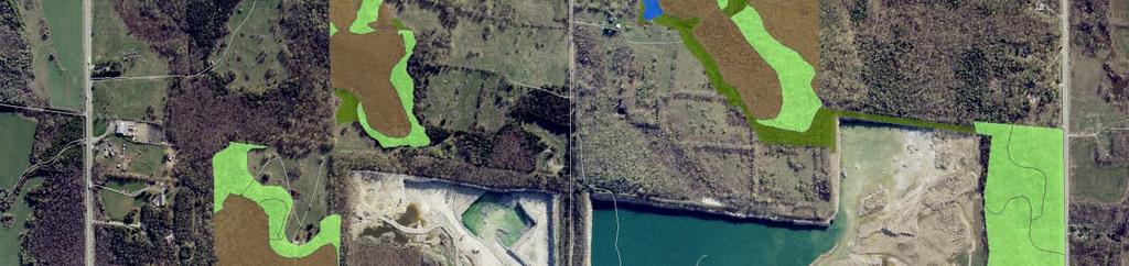
1 BLACK CREEK VALLEY V:\01609\active\2001 Active Projects\ \G1188\graphics\GIS\MXD\_Final Draft Sept 2008\MXD\Section_7\ _Fig7-1_ProposedNaturalAreasMngmtStrategyBCWSNorth_28Nov08_MC.mxd HIGHWAY 25 22ND SIDE ROAD SIGNIFICANT WETLAND 3RD LINE 3RD LINE Existing Licensed Lands Dufferin Additional Lands Proposed License Boundary Tree Planting Active Forest Management Passive Forest Management Grassland and Thicket Management Wetland Improvement Metres 1:10,000 FIGURE NO. 7.1 OFFSITE NATURAL AREAS MANAGEMENT STRATEGY BLACK CREEK WATERSHED Date Prepared: December 9, 2008 Disclaimer: The information included on this map has been compiled for Dufferin Aggregates from a variety of sources. Projection: UTM Zone 17N, Datum: NAD83.

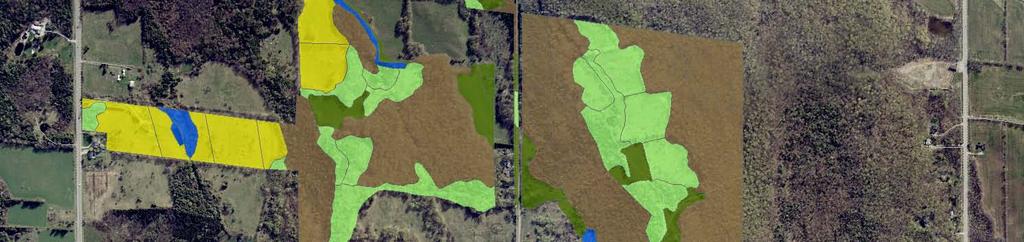
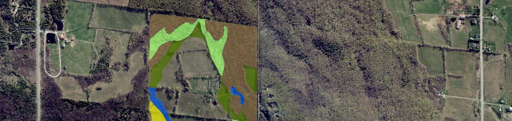
2 V:\01609\active\2001 Active Projects\ \G1188\graphics\GIS\MXD\_Final Draft Sept 2008\MXD\Section_7\ _Fig7-2_ProposedNaturalAreasMngmtStrategySMCWSSouth_28Nov08_MC.mxd REGIONAL ROAD 25 22ND SIDE ROAD 17TH SIDE ROAD NORTHWEST EAST-WEST SIGNIFICANT WETLAND 3RD LINE NIAGARA ESCARPMENT SOUTHEAST NORTHEAST FOD5-1 4TH LINE Existing Licensed Lands Dufferin Additional Lands Proposed License Boundary Tree Planting Active Forest Management Passive Forest Management Grassland and Thicket Management FIGURE NO. 7.2 Wetland Improvement Proposed Amphibian Ponds Metres Scotch Block Tributary OFFSITE NATURAL AREAS MANAGEMENT STRATEGY 16 MILE CREEK WATERSHED Date Prepared: December 9, 2008 Disclaimer: The information included on this map has been compiled for Dufferin Aggregates from a variety of sources. 1:12,500 Projection: UTM Zone 17N, Datum: NAD83.

 GRADING & TING (NORTHWEST) FOR GRADING AND NORTHEAST")
3 V:\01609\active\2001 Active Projects\ \G1188\landscape architecture\ _jesaponds_10-3.ai 4 70 PREPARED FOR: DUFFERIN AGGEGATES AGGREGATES 7.3 FIGURE NO CONCEPTUAL (NORTHEAST) GRADING & TING (NORTHWEST) FOR GRADING AND NORTHEAST TING AMPHIBIAN POND February 15, 2008 Date Prepared: Nov 20, 2008


4 V:\01609\active\2001 Active Projects\ \G1188\landscape architecture\ _jesaponds_10-2.ai 400 AGGEGATES FIGURE NO CONCEPTUAL GRADING & TING (NORTHWEST) FOR GRADING AND SOUTHEAST TING AMPHIBIAN POND February 15, 2008 Date Prepared: Nov 20, 2008


5 V:\01609\active\2001 Active Projects\ \G1188\landscape architecture\ _jesaponds_10-5.ai WOODLAND BOUNDARY WETLAND BOUNDARY WETLAND W3 WHITE CEDAR - HARDWOOD ORGANIC MIXED SWAMP EXISTING GRADE GRADE POND LINER SEEPAGE THROUGH BERM AGGREGATES PREPARED FOR: DUFFERIN AGGEGATES FIGURE NO CONCEPTUAL GRADING & TING (NORTHWEST) FOR GRADING AND NORTHWEST TING AMPHIBIAN POND Date Prepared: Nov 20, 2008 Date Prepared: February 15, 2008

6 3RD LINE Naturalized Discharge Channel HIGHWAY 25 22ND SIDE ROAD 3RD LINE 4TH LINE V:\01609\active\2001 Active Projects\ \G1188\graphics\GIS\MXD\_Final Draft Sept 2008\MXD\Section_7\ _Fig7-5_RehabilitationPlan_2Dec08_MC.mxd REGIONAL ROAD 25 Note: Existing quarry rehabilitation is a proposed landform only. Pending MNR review. Existing Licensed Lands Dufferin Additional Lands Proposed License Boundary Deep Water Shoreline Marsh Forest (Mix of Upland and Bottomland) Old Field Meadow Talus Cliff FIGURE NO. 7.6 REHABILITATION Metres 1:12,500 Date Prepared: December 2, 2008 Disclaimer: The information included on this map has been compiled for Dufferin Aggregates from a variety of sources. Projection: UTM Zone 17N, Datum: NAD83.


7 High Exposed Perch Beech Fagus grandifolia Hemlock Tsuga canadensis Rock outcropping Alternate-leaf dogwood Cornus alternifolia Sugar maple Acer saccharum V:\01609\active\2001 Active Projects\ \G1188\landscape architecture\sketches\ _rehabilitation_fig1.ai White cedar Thuja occidentalis Red raspberry Rubus idaeus Leaf litter & downed woody debris Snag tree / Cavity tree Yellow birch Betula allegheniensis UD FOREST Trembling aspen Populus tremuloides BOTTOMLAND FOREST FIGURE NO. 7.7 SCHEMATICS OF ECOLOGICAL FEATURES Date Prepared: Nov 20, 2008


 depth varies between 2m and 5m. CLIFF AND TALUS FIGURE NO. 7.")
8 Rock overhang Eastern white cedar Thuja occidentalis V:\01609\active\2001 Active Projects\ \G1188\landscape architecture\sketches\ _rehabilitation_fig3.ai Rock ledge Eastern white cedar Thuja occidentalis Woody debris Water level (varies) If primary slope material is fill, ensure that talus (rock) depth varies between 2m and 5m. CLIFF AND TALUS FIGURE NO. 7.8 SCHEMATICS OF ECOLOGICAL FEATURES Date Prepared: Nov 20, 2008


9 High exposed perch Snake hibernaculum (rock pile to below frost) Mix of native grass and forb species Woody debris Low exposed perch V:\01609\active\2001 Active Projects\ \G1188\landscape architecture\sketches\ Fig7.4.ai Bladderwort Utricularia sp. Narrow-leaved cattail Typha angustifolia Speckled alder Alnus incana rugosa Basking log Pondweed Potamogeton sp. Submerged logs & rocks OLD FIELD Exposed perch SHORELINE WETLAND FIGURE NO. 7.9 SCHEMATICS OF ECOLOGICAL FEATURES Date Prepared: Nov 20, 2008
Healthy Living Strategy: Shorelines
 Healthy Living Strategy: Shorelines Shoreline Vegetation in Muskoka The basis of a natural ecosystem is a complex combination of vegetation that forms canopy, understory, and herbaceous layers. It is easier
St. Croix River Crossing Project - Visual Quality Manual
 St. Croix River Crossing Project - Visual Quality Manual Minnesota TH 36/TH 95 Interchange 3.1 Context Existing TH 36/TH 95 Environment The proposed TH 36/TH 95 interchange will occupy a large area of
MILL POND OVERLOOK. A project of the Town of Oyster Bay. Prepared by Cameron Engineering & Associates, LLP
 MILL POND OVERLOOK A project of the Town of Oyster Bay Prepared by Cameron Engineering & Associates, LLP Funded in part through an EPF grant from the NYS Department of State Project Goals & Advisory Committee
Brandon J. Bushen 1 ABSTRACT
 Report on the 6 th year of monitoring vegetative succession along the Volney-Marcy South power line right of way in Greenwoods Conservancy, summer 2004 Brandon J. Bushen 1 ABSTRACT This report summarizes
VISUAL IMPACT ASSESSMENT
 VISUAL IMPACT ASSESSMENT JULY 2010 / 9061V DUFFERIN AGGREGATES PROPOSED EXTENSION OF THE ACTON QUARRY CONTENTS 1.0 Introduction 3 1.1 Description of the Proposed Extension 3 1.2 Purpose 3 1.3 Description
Shoreline Habitat Creation Manual. Protecting our Biodiversity
 Shoreline Habitat Creation Manual Protecting our Biodiversity Habitat Creation Manual Habitat Creation Manual This manual is intended for landowners wanting to enhance their properties, or create habitat
memo Project Name Little Lake Point Intercept Survey 2017 Date 9/5/17 To / Contact info Jerry Spetzman Cc / Contact info Greg Graske, PE
 memo Project Name Little Lake Point Intercept Survey 2017 Date 9/5/17 To / Contact info Cc / Contact info From / Contact info Regarding Jerry Spetzman Greg Graske, PE Joe Pallardy, Mike Majeski Little
319 Grant: Baker Creek & Centenary Creek Restoration Initiative
 319 Grant: Baker Creek & Centenary Creek Restoration Initiative Objectives: Overview of Watershed Characteristics: Discussion of Project Tasks: Discussion of Watershed Management Plan: Presented by: Erich
Attracting Birds and Wildlife to the Garden. Spring 2015 Garden Smarter Series Kent Phillips Howard County Master Gardener
 Attracting Birds and Wildlife to the Garden Spring 2015 Garden Smarter Series Kent Phillips Howard County Master Gardener College of Agriculture and Natural Resources 2 Some possibilities Other possibilities
Oil Sands Reclamation From the Ground Up : A Suncor Energy Perspective
 Oil Sands Reclamation From the Ground Up : A Suncor Energy Perspective Lelaynia Cox, RPF and Cecilia Jeje, PhD College of Alberta Professional Forest Technologists April 14, 2011 Overview Oil sands mining
Information for File # ARC
 Information for File # 2017-03115-ARC Applicant Consultant Corps Contact Bob Manzoline St. Louis and Lake Counties Regional Rail Authority Natalie White Short Elliot Hendrickson (SEH) Inc. Andrew R Chambers
NAPA COUNTY LAND USE PLAN
 NAPA COUNTY LAND USE PLAN 2008-2030 * LEGEND URBANIZED OR NON-AGRICULTURAL Cities Urban Residential Rural Residential Industrial Public-Institutional Study Area OPEN SPACE * * Agriculture, Watershed &
McCormick Pit Category 1 Class A License, Pit Below Water For Blueland Farms Limited. Visual Impact Assessment Report February 2013
 McCormick Pit Category 1 Class A License, Pit Below Water For Blueland Farms Limited Visual Impact Assessment Report February 2013 TABLE OF CONTENTS EXECUTIVE SUMMARY... v 1.0 BACKGROUND... 1 Figure 1.
Hiawatha Drain County Drain or Habitat Restoration?
 Michigan Water Environment Association 2018 Conference June 25, 2018 Dana Burd, PE Melanie Manion, Ottawa County Natural Resources Supervisor Hiawatha Drain County Drain or Habitat Restoration? Joe Bush,
Landscape Conservation Design April, 2014
 Designing Sustainable Landscapes in the Northeast A project of the North Atlantic Landscape Conservation Cooperative & Northeast Climate Science Center Landscape Conservation Design April, 2014 Conceptual
LAND DEVELOPMENT REGULATIONS
 Adopted by City Planning Commission on June 3, 1997 Approved by City Council on July 7, 1997 Revised by City Council on June 15, 1998 Revised by City Council on March 15, 2004 LAND DEVELOPMENT REGULATIONS
BASS PONDS, MARSH, & WETLAND HABITAT RESTORATION PROJECT
 FACT SHEET BASS PONDS, MARSH, & WETLAND HABITAT RESTORATION PROJECT MINNESOTA VALLEY NATIONAL WILDLIFE REFUGE, MINNESOTA ENVIRONMENTAL MANAGEMENT PROGRAM LOCATION Three areas located on the Minnesota Valley
TREE CONSERVATION REPORT 555 DEALERSHIP DRIVE, OTTAWA
 TREE CONSERVATION REPORT 555 DEALERSHIP DRIVE, OTTAWA PREPARED FOR: CURTIS MELANSON, C.E.T. MCINTOSH PERRY 115 WALGREEN ROAD, R.R. 3 CARP, ON K0A 1L0 613-836-2184 EXT. 2240 PREPARED BY: ANDREW BOYD, B.SC.F,
2019 Evergreen Tree Availability. Item - Latin Name Item - Common Name Size
 Abies balsamea v. phanerolepis Canaan Fir 4/5' Abies balsamea v. phanerolepis Canaan Fir 5/6' Abies balsamea v. phanerolepis Canaan Fir 6/7' Abies balsamea v. phanerolepis Canaan Fir 7/8' Abies balsamea
APPENDIX 1: SCOPED ENVIRONMENTAL IMPACT STATEMENT (EIS) FORM
 FORM") APPENDIX 1: SCOPED ENVIRONMENTAL IMPACT STATEMENT (EIS) FORM This form is intended for use by applicants (primarily private landowners) who need to conduct a Scoped EIS in support of minor development
APPENDIX 1: SCOPED ENVIRONMENTAL IMPACT STATEMENT (EIS) FORM This form is intended for use by applicants (primarily private landowners) who need to conduct a Scoped EIS in support of minor development
SOUTH PARK. Construction of a Portion of South Park at Fresh Kills Park, Staten Island
 SOUTH PARK Construction of a Portion of South Park at Fresh Kills Park, Staten Island FRESHKILLS PARK FIRST PHASE OF SOUTH PARK FRESHKILLS PARK CONTEXT SOUTH PARK EXISTING CONDITIONS PROJECT OPPORTUNITIES
A Production of the University WI-Ext.
 A Production of the University WI-Ext. Water is the most critical resource issue of our lifetime and our children s lifetime. The health of our waters is the principal measure of how we live on the land
SITE INTRODUCTIONS AND OVERVIEW
 SITE INTRODUCTIONS AND OVERVIEW The City s formal Open Space Program was established in 1990 to implement long-standing policies that called for the protection of the farmlands and wild areas that surround
Northern Neck Native Plant Trail
 Northern Neck Native Plant Trail DEMONSTRATION GARDENS ON THE NORTHERN NECK 1 2 Westmoreland State Park Visitors Center 145 Cliff Road Montross, VA 22520 Stratford Hall (across from entrance booth) 48
Grave Creek Riparian Revegetation 2011 Implementation Report
 Task Order #1008 Grave Creek Riparian Revegetation 2011 Implementation Report Prepared for: Kootenai River Network P.O. Box 491 Libby, MT 59923 Prepared by: Geum Environmental Consulting, Inc. 307 State
2004 RARE PLANT SURVEY at the PolyMet Mine Site located in T59N R13W. Prepared by Deborah Pomroy with assistance from Raymond Barnes
 2004 RARE PLANT SURVEY at the PolyMet Mine Site located in T59N R13W Prepared by Deborah Pomroy with assistance from Raymond Barnes Prepared for Barr Engineering August 2004 INTRODUCTION A rare plant survey
WETLAND SOD u Bare Root Wetland Plants u Deep Rooted Willows u Coir Logs u Native Trees & Shrubs u Habitat Islands u Custom Growing
 WETLAND SOD u Bare Root Wetland Plants u Deep Rooted Willows u Coir Logs u Native Trees & Shrubs u Habitat Islands u Custom Growing 2009 PROJECT HIGHLIGHTS The following 10 projects highlight the interesting
Information for File # JTF
 Information for File # 2013-04665-JTF Applicant Corps Contact Enbridge Energy, Limited Partnership Josh Fitzpatrick Address 1554 Highway 2, Suite 2, Two Harbors, MN 55616 E-Mail joshua.t.fitzpatrick@usace.army.mil
Each One Teach One Habitat Features Snags
 Each One Teach One Habitat Features Snags Snags are tree trunks that remain standing after the tree has died. Snags can stand for many years before falling to earth to become a nurselog. Woodpeckers make
NOTICE OF PREPARATION
 NOTICE OF PREPARATION DATE: January 6, 2016 TO: LEAD AGENCY: Responsible Agencies, Organizations, and Interested Parties Contact: Tyler Barrington, Principal Planner Planning Department Community Development
Philbrook Avenue Wetlands and Stream Riparian Restoration Project Planting Plan 2009 REVISED AUGUST 24, 2009
 Philbrook Avenue Wetlands and Stream Riparian Restoration Project Planting Plan 2009 REVISED AUGUST 24, 2009 Submitted by Boyle Associates Per Request of Gorrill Palmer Consulting Engineers & the Cumberland
Riparian Planting Plan Requirements 21 October 2013
 Riparian Planting Plan Requirements 21 October 2013 a. Planting a riparian area with trees and shrubs evenly interspersed. The size of the riparian area must be at least 1:1 ratio with the amount of overwater
ESPA 33 (Stauffer Woods) ESPA 34 (Doon South Woods) Environmentally Sensitive Policy Area (ESPA)
 ESPA 34 (Doon South Woods) Environmentally Sensitive Policy Area (ESPA)") Living in Harmony with Nature, Kitchener, Ontario As a resident of the Doon South community, you are fortunate to live in a place that is rich with natural environmental areas. One of the key guiding principles
Living in Harmony with Nature, Kitchener, Ontario As a resident of the Doon South community, you are fortunate to live in a place that is rich with natural environmental areas. One of the key guiding principles
Appendix I West Brampton Watermain Natural Environment Report
 Appendix I West Brampton Watermain Natural Environment Report December 20, 2012 The Municipal Infrastructure Group Ltd 8800 Dufferin Street, Suite 200 Vaughan, Ontario L4K 0C5 Attention: Angela Carley
Tentatively Selected Plan within Harlem River, East River and Western Long Island Sound Planning Region. First Level Costs. Federal Non-Federal Total
 HARLEM RIVER, EAST RIVER AND WESTERN LONG ISLAND SOUND PLANNING REGION Flushing Bay and Creek Ecosystem Restoration Source Feasibility Study Background Study Resolution (1994), Reconnaissance Report (1996),
TRCA Field Staking Protocol December 2016
 Page 1 of 6 TRCA Field Staking Protocol December 2016 This Protocol describes TRCA staff s current practice for field staking the physical top of bank, the physical toe of slope, and the limit of existing
PART IV - LAND USE POLICIES - RURAL PLANNING AREA
 PART IV - LAND USE POLICIES - RURAL PLANNING AREA 1.0 INTRODUCTION *D9 This part of the Plan presents the principles, objectives and policies for the land use designations identified on the Settlement
Meeting Agenda. City of Guelph. River Systems Advisory Committee. Agenda Items. Item 1, 2 and 3. Item 4 Ward to Downtown Pedestrian Bridge
 Meeting Agenda City of Guelph River Systems Advisory Committee September 19, 2018 City Hall, Meeting Room B From 4:00 to 6:00 p.m. Meeting Chair: Mariette Pushkar Agenda Items Welcome to all Item 1, 2
Propagating Recommended Bluff Plants
 Propagating Recommended Bluff Plants Shrubs Silky Dogwood, Cornus sericea Seed propagation: Gather these seeds in the fall. You should remove the fruit flesh because it inhibits germination, and stratify
Cedar Niles Future Park Site Wetland #1
 Date: October 20, 2014 Site: Landowner: Johnson County Parks Designer: Thomas R. Biebighauser Individuals Present: Thomas R. Biebighauser, Dr. Eliodora Chamberlain (US EPA), Jason Daniels (US EPA), Jeannette
Chagrin River Watershed Partners, Inc. Local Regulations. Amy H. Brennan (440)
") Chagrin River Watershed Partners, Inc. Local Regulations Amy H. Brennan (440) 975-3870 www.crwp.org abrennan@crwp.org July 9, 2013 Applicable Zoning and Building Codes Erosion and Sediment Control Grading
Chagrin River Watershed Partners, Inc. Local Regulations Amy H. Brennan (440) 975-3870 www.crwp.org abrennan@crwp.org July 9, 2013 Applicable Zoning and Building Codes Erosion and Sediment Control Grading
1. How do I Improve the Quality of my Waterways?
 The Centre for Land and Water Stewardship Trees and Wildlife in the Equine Landscape Horse farms are rapidly becoming a more common site in the Southern Ontarian landscape, taking up many more acres of
Horner-McLaughlin Woods: Soil Types
 Horner-McLaughlin Woods: Soil Types Not present at HMW Adrian Muck Conover Loam 0-4% Slopes Houghton Muck Miami Loam 2-6% Slopes Miami Loam 6-12% Slopes Miami Loam 12-18% Slopes t 0 0.125 0.25 Miles Mary
Habitat Improvements to the Motor Island Shoreline in the Upper Niagara River, NY: A Collaborative Approach
 Habitat Improvements to the Motor Island Shoreline in the Upper Niagara River, NY: A Collaborative Approach Edward Alkiewicz 1, Stephen Schoenwiesner 1, Jeff Gerlach 1, Morris Perot 2, Scott Ault 2, Mark
las vegas wash coordination committee
 las vegas wash coordination committee lvwash.org DU Wetlands No. 1 Weir Planting Plan February 2013 DU Wetlands No. 1 Weir Planting Plan SOUTHERN NEVADA WATER AUTHORITY Las Vegas Wash Project Coordination
memo Project Name Spider Lake Point Intercept Survey 2017 Date 9/5/17 To / Contact info Jerry Spetzman Cc / Contact info Greg Graske, PE
 memo Project Name Spider Lake Point Intercept Survey 2017 Date 9/5/17 To / Contact info Cc / Contact info From / Contact info Regarding Jerry Spetzman Greg Graske, PE Joe Pallardy, Mike Majeski Spider
3-2 Environmental Systems
 3-2 Environmental Systems 3.0 ENVIRONMENTAL SYSTEMS CONTENTS 3.1 GREENWAY SYSTEM 3.1.1 General Policies 3.1.2 Natural Heritage Network 3.1.3 Natural Heritage Network Enhancement Lands 3.1.4 Rouge Watershed
Reading the Driftless Landscape
 Reading the Driftless Landscape Author, Cindy Ramseyer Editors and Contributors: Katie Abbott, Chuck Bauer, Darcy Kind, Heidi Nelson, Carroll Schaal A Publication of the Blue Mounds Area Project with generous
Planning for Staten. Habitat Restoration and Green Infrastructure. Island s North Shore
 Habitat Restoration and Green Infrastructure Planning for Staten Island s North Shore Community Board 1 March 1, 2018 NYC Parks Forestry, Horticulture, and Natural Resources Funded by the NYS Department
WELCOME TO PUBLIC INFORMATION CENTRE #2. Please Sign In
 WELCOME TO PUBLIC INFORMATION CENTRE #2 Replacement of Oxtongue Lake Narrows Bridge & Oxtongue River Bridge, Highway 60 (G.W.P. 93-89-00 & G.W.P. 5550-04-00) Class Environmental Assessment (Group B) Please
Natural Heritage areas are characterized by one or more of the following values:
 SECTION 6: LAND USE POLICIES - NATURAL HERITAGE The Natural Heritage policies reference features and areas that provide ecological functions critical to the survival of all species - including humans.
Conservation Plan. I. Property Information. II. Objectives. Natural Resource Objectives. Sustainability in Practice (SIP) Certified
 Certified") Conservation Plan Sustainability in Practice (SIP) Certified I. Property Information Vineyard Name and Establishment Date: Location: Map (attach showing blocks and acres): II. Objectives Natural Resource
Conservation Plan Sustainability in Practice (SIP) Certified I. Property Information Vineyard Name and Establishment Date: Location: Map (attach showing blocks and acres): II. Objectives Natural Resource
Aquatic Vegetation of Big Swan Lake Todd County, Minnesota (DOW ) June 3, 4, 15, 2004
 June 3, 4, 15, 2004") Aquatic Vegetation of Big Swan Lake Todd County, Minnesota (DOW 77-0023-00) June 3, 4, 15, 2004 N 200 0 200 400 Meters Report by: Donna Perleberg Minnesota Department of Natural Resources Division of Ecological
Aquatic Vegetation of Big Swan Lake Todd County, Minnesota (DOW 77-0023-00) June 3, 4, 15, 2004 N 200 0 200 400 Meters Report by: Donna Perleberg Minnesota Department of Natural Resources Division of Ecological
1/21/2014. Definitions vary widely Legal vs. functional Not always obvious. Wetlands are legally protected by Clean Water Act (1972)
") What is a Wetland? Freshwater Wetlands of Gulf Coast Plains Definitions vary widely Legal vs. functional Not always obvious What is a Wetland? Wetlands are legally protected by Clean Water Act (1972) Corps
What is a Wetland? Freshwater Wetlands of Gulf Coast Plains Definitions vary widely Legal vs. functional Not always obvious What is a Wetland? Wetlands are legally protected by Clean Water Act (1972) Corps
Exceptional ecological landscapes support wildlife across New Hampshire
 Natural Com Exceptional ecological landscapes support wildlife across New Hampshire T he natural landscape of New Hampshire offers a fascinating study of great contrasts and rich biological wonders. To
April 11, 2016 Park Board Chair and Commissioners General Manager Vancouver Board of Parks and Recreation New Brighton Salt Marsh - Preferred Concept
 TO: FROM: SUBJECT: April 11, 2016 Park Board Chair and Commissioners General Manager Vancouver Board of Parks and Recreation New Brighton Salt Marsh - Preferred Concept RECOMMENDATION A. THAT the Vancouver
Verde Valley Landscape Character Type
 Existing Condition Landscape Character The existing landscape character describes the existing set of valued aesthetic attributes for the current landscape. The landscape character descriptions include
Forest Preserves of Cook County Species Treatment List
 Woody Plants Common Name Scientific Name Treatment Options Treatment Season Tree of Heaven Alianthus altissima Basal bark application, use 20% Element 4 (better option) Cut and treat stems with a 20% Element
Natural Areas Inventory Update. Executive Summary
 Montgomery County planning commission Natural Areas Inventory Update Executive Summary Executive Summary Despite continuing development and resulting suburban sprawl, significant areas of open space remain
D RAFT MEMORANDUM CURRENT PLANTING TECHNIQUES. Technique 1: Bioengineered Brush Layering. To: Date: January 20, 2016
 720 Olive Way, Suite 1900 Seattle, Washington 98101 Phone 206.287.9130 Fax 206.287.9131 www.anchorqea.com D RAFT MEMORANDUM To: Rob Wenman, Pierce County Public Works and Utilities Date: From: Betsy Severtsen,
Appendix A Functional Assessment for Potential Agricultural Agriculture Wetland Evaluation Bank Tool
 Appendix A Functional Assessment for Potential Agricultural Agriculture Wetland Evaluation Bank Tool BWSR Technical Guidance Version 1.0, June 26, 2013 This wetland functional assessment tool was developed
SUBCHAPTER 23-6: LANDSCAPING AND BUFFERYARD REGULATIONS
 SUBCHAPTER 23-6: LANDSCAPING AND BUFFERYARD REGULATIONS Section 23.601 Purpose The purpose of this Subchapter is to indicate the minimum requirements for the landscaping of foundations, developed lots,
STORMWATER MANAGEMENT CRITERIA APPENDIX D: STORMWATER MANAGEMENT POND DESIGN GUIDANCE D. i APPENDIX D 1 STORMWATER MANAGEMENT POND PLANTING GUIDELINES
 STORMWATER MANAGEMENT CRITERIA APPENDIX D: STORMWATER MANAGEMENT POND DESIGN GUIDANCE D. i APPENDIX D 1 STORMWATER MANAGEMENT POND PLANTING GUIDELINES CREDIT VALLEY CONSERVATION AUTHORITY July 2014 D.
AMENDMENT NO. 30 TO THE OFFICIAL PLAN OF THE TOWN OF MILTON
 AMENDMENT NO. 30 TO THE OFFICIAL PLAN OF THE TOWN OF MILTON Subject: Boyne Survey Secondary Plan and Related Official Plan Amendments The following text and schedules constitute Amendment No. 30 to the
SUBCHAPTER 6: LANDSCAPING AND BUFFERYARD REGULATIONS
 SUBCHAPTER 6: LANDSCAPING AND BUFFERYARD REGULATIONS 22.600 PURPOSE The purpose of this Article is to indicate the minimum requirements for the landscaping of foundations, developed lots, street frontages,
Forest Grove Park Master Plan
 Workshop 03 Steering Committee Meeting 2:00 5:00 PM Public Open House 5:00 7:00 PM February 21, 2012 Agenda February 21, 2012 Schedule and planning process update. Preliminary Program review. Concept plan
Master Plan for the Cheltenham Badlands. Public Meeting #1 October 13, 2015
 October 13, 2015 2 Sign-in 10 min. Presentation (Dillon/OHT) 30 min. Questions and Answers (Dillon/OHT) 15 min. Break-out Discussion Groups (Self-directed) 40 min. Reporting Back 20 min. Closing Remarks
Bioretention Facilities in Retrofit Conditions. City of Calgary Pilot Projects at Carburn and Deerfoot Parks
 Bioretention Facilities in Retrofit Conditions City of Calgary Pilot Projects at Carburn and Deerfoot Parks Overview 2 1. City of Calgary bioretention pilot project 2. About the Parks 3. How bioretention
BISCUIT RUN PARK MASTER PLAN
 BOARD OF SUPERVISORS November 14, 2018 BISCUIT RUN PARK MASTER PLAN COUNTY OF ALBEMARLE ANHOLD ASSOCIATES Contents Project Introduction Property Background County Park Planning Process Existing Site &
Fresh Kills Park in Regional Context
 Fresh Kills Park in Regional Context Fresh Kills Location On Staten Island Community District 1 THE SITE TODAY TRAVIS William T. Davis Wildlife Refuge New Jersey NEW SPRINGVILLE MOUND 3/4 Little Fresh
Biodiversity Conservation
 Biodiversity Conservation and Site Plan Review Biodiversity conservation principles Threats to biodiversity Location of development Reviewing site plans Lunch Reviewing site plans (continued) LEED and
The Bruce Trail: your good neighbour
 The Bruce Trail: your good neighbour HELP US PROTECT OUR CONSERVATION CORRIDOR The Bruce Trail Conservancy Our Mission The Bruce Trail Conservancy is a charitable organization committed to establishing
South Waterfront Park
 South Waterfront Park The South Waterfront Greenway Development Plan (GDP) has achieved an integrated and balanced design that fuses the goal of creating a new high-density urban community with the desire
Oneida Lake Native Shoreline Restoration Incentive Program
 Narrative: Oneida Lake Native Shoreline Restoration Incentive Program The goal of this project was to restore native plants to the shoreline of Oneida Lake, on private year round residences. In addition,
 N 2x ball dia. min. Rubber hoses Guy wires Leave minimal slack/ play, do not tighten () Hardwood stakes, 2"x2"x8' ht. () Set rootflare " higher than surrounding grade. Remove excess soil to expose trunk
Draft Master Plan for Franklin Park
 Draft Master Plan for Franklin Park Metro Parks Tacoma with SiteWorkshop November 2009 I. overview & background Process & History Master Plan Process The Master Plan is based on a community involvement
Wisconsin Dept. of Transportation November 2017
 Wisconsin Dept. of Transportation November 2017 Jennifer Gibson WisDOT Environmental Coordinator Mike Helmrick WisDOT Environmental Coordinator Background on compensatory wetland mitigation Site purpose
YEAR 2 FIRST QUARTER REPORT
 ENVIRONMENTAL STEWARDSHIP PROJECT YEAR 2 FIRST QUARTER REPORT DECEMBER 23, 2009 Prepared for: NATIONAL OCEANIC AND ATMOSPHERIC ADMINISTRATION Prepared by: CITY OF TACOMA 1.0 Introduction In accordance
LILAC Housing: Site Management Plan
 LILAC Housing: Site Management Plan Prepared by: Joe Atkinson. Date: 30/10/2011 Version 1.0 Relevant Legislation & Policy Conservation Regulations 1994, 2007, 2009, 2010 Wildlife & Countryside Act 1981;
Southern Auto Sales, Inc.
 Southern Auto Sales, Inc. File No.: 199700775 City and State: East Windsor, CT General Impacts: 3.8 acres forested Functions and Values Lost: (From EA/SOF) Wildlife Habitat Year(s) Mitigation Constructed:
Flat Lake, Highway 103, HADD Compensation Project (DFO HADD Authorization 03-G8-068): 2010 Vegetation Monitoring
: 2010 Vegetation Monitoring") Flat Lake, Highway 103, HADD Compensation Project (DFO HADD Authorization 03-G8-068): 2010 Vegetation Monitoring Year 5 Final Diane LaRue, Vegetation Consultant Environmental Services, NSTIR Monitored
Flat Lake, Highway 103, HADD Compensation Project (DFO HADD Authorization 03-G8-068): 2010 Vegetation Monitoring Year 5 Final Diane LaRue, Vegetation Consultant Environmental Services, NSTIR Monitored
Wetland Restoration In Altered Landscapes
 Wetland Restoration In Altered Landscapes Mike McClure, Wetland Service Biologist, MO Dept. of Conservation Wetland Restoration In Altered Landscapes Do s, Don ts and Things To Think About Assessing the
Aquatic Vegetation of Edward Lake Crow Wing County, Minnesota (DOW ) July 8, 9, 14, 26; August 2, 2004
 July 8, 9, 14, 26; August 2, 2004") Aquatic Vegetation of Edward Lake Crow Wing County, Minnesota (DOW 18-0305-00) July 8, 9, 14, 26; August 2, 2004 Report by: Donna Perleberg Minnesota Department of Natural Resources Division of Ecological
Aquatic Vegetation of Edward Lake Crow Wing County, Minnesota (DOW 18-0305-00) July 8, 9, 14, 26; August 2, 2004 Report by: Donna Perleberg Minnesota Department of Natural Resources Division of Ecological
Appendix A Basin Inventory Summary
 Appendix A Basin Inventory Summary Surface Water Management Element A-1 BASIN INVENTORY SUMMARY Pinellas County is divided into 52 individual watersheds. The following Basin Inventory Summary includes
III. PROJECT DESCRIPTION
 III. PROJECT DESCRIPTION A. PROJECT LOCATION Regional Setting The project site is located in the southeast quadrant of the City of Chico in Butte County, California and is comprised of four parcels totaling
BLACK/HARMONY/FAREWELL CREEK WATERSHED EXISTING CONDITIONS REPORT CHAPTER 5 IMPERVIOUS SURFACES
 BLACK/HARMONY/FAREWELL CREEK WATERSHED EXISTING CONDITIONS REPORT CHAPTER 5 IMPERVIOUS SURFACES Draft November 2009 TABLE OF CONTENTS 1.0 INTRODUCTION... 3 2.0 STUDY AREA AND SCOPE... 4 3.0 METHODOLOGY...
Saugus River Watershed Invasive Aquatic Vegetation Assessment
 Saugus River Watershed Invasive Aquatic Vegetation Assessment ================================== DECEMBER 2008 Prepared For: Saugus River Watershed Council c/o Joan LeBlanc, Executive Director P.O. Box
Coyote Hills Restoration and Public Access Project Coyote Hills Regional Park C o n c e p t P l a n a n d S i t e P r o g r a m
 Coyote Hills Restoration and Public Access Project Coyote Hills Regional Park C o n c e p t P l a n a n d S i t e P r o g r a m Chris Barton Environmental Programs Manager Aquisition Stewardship Development
Maintaining Your Naturalized Shoreline. Native Plant Care Guide
 Maintaining Your Naturalized Shoreline Native Plant Care Guide Native Plant Care Guide Shoreline Vegetation Stewardship Manual This manual is intended for landowners participating in the Natural Edge Shoreline
Maintaining Your Naturalized Shoreline. Shoreline Vegetation. stewardship manual
 Maintaining Your Naturalized Shoreline Shoreline Vegetation stewardship manual The Importance of Shoreline Vegetation Vegetation along shorelines of any body of water, including lakes, rivers, creeks,
THAT a Community Enhancement Program be established with the following guidelines:
 68 ISSUED: JULY 6, 1982 REVISED: JULY, 2010; MAR 21/00; JUNE 12/89; DEC 3/91 & JAN 25/94 PREPARED BY: DIRECTOR OF MUNICIPAL SERVICES AUTHORIZED BY: COUNCIL TITLE: COMMUNITY ENHANCEMENT PROGRAM - MEMORIAL
Environmental Impact Study 1856 Notion Road, City of Pickering
 GUIDING SOLUTIONS IN THE NATURAL ENVIRONMENT Environmental Impact Study 1856 Notion Road, City of Pickering Prepared For: Metropia (Notion Road) Developments Inc. Prepared By: Beacon Environmental Limited
What is a Riparian Area and How Does It Benefit You?
 Planning Your Riparian Planting Project in Alberta What is a Riparian Area and How Does It Benefit You? Riparian areas are found next to water, including stream and river floodplains, lakeshore and wetland
Designation of Critical Habitat Areas Jacqueline Lake, Portage County. Wisconsin Department of Natural Resources Eau Claire, WI
 Designation of Critical Habitat Areas Jacqueline Lake, Portage County Wisconsin Department of Natural Resources Eau Claire, WI 2006 Critical Habitat Area Designation Jacqueline Lake, Portage County I.
ARTICLE VI: Landscaping and Bufferyard Regulations
 ARTICLE VI: Landscaping and Bufferyard Regulations Section 18.601: Purpose The purpose of this Article is to indicate the minimum requirements for the landscaping of foundations, developed lots, street
I. INTRODUCTION SITE DESCRIPTION
 Request for Proposals Design Services for the Visitor Access and Engagement Project at Roy s Redwoods Open Space Preserve Marin County Parks & Open Space Preserve Woodacre, Marin County, CA November 12,
APPENDIX C NATURAL RESOURCES MANAGEMENT PLAN: ACTIONS AND PRIORITIES
 APPENDIX C NATURAL RESOURCES MANAGEMENT PLAN: ACTIONS AND PRIORITIES TABLE C-1: Resource Actions and Priorities GOAL NRM-4 Objective 4.1: Restore Natural floodplain functions. Objective 4.2: Define and
Stormwater Standards. Clackamas County Service District No. 1. Planting Guide for Buffers
 Stormwater Standards Clackamas County Service District No. 1 APPENDIX B Planting Guide for Buffers Table of Contents Appendix B - Planting Guide for Buffers... Page B.1 General... 1 B.1.1 Introduction...
2014 HDR 2014 Architecture, HDR, Inc., all all rights reserved. reserved.
 2014 HDR 2014 Architecture, HDR, Inc., all all rights reserved. reserved. Uplift of a Wet Weather Stream: Satisfying Regulatory Requirements Agawela Drive Stream Project Chattanooga, TN 2014 HDR, Inc.,
SOUTH FOX MEADOW STORMWATER IMPROVEMENT PROJECT
 VILLAGE OF SCARSDALE WESTCHESTER COUNTY, NEW YORK COMPREHENSIVE STORM WATER MANAGEMENT SOUTH FOX MEADOW STORMWATER IMPROVEMENT PROJECT In association with WESTCHESTER COUNTY FLOOD MITIGATION PROGRAM Rob