LISMORE PARK, KELLY S FLAT, ALLENBY PARK, FAULKS TERRACE, DOMINI PARK & KENNEDY CRESCENT
|
|
|
- Magdalene Floyd
- 5 years ago
- Views:
Transcription
1 Attachment A: PROPOSED RESERVE MANAGEMENT PLAN FOR THE RECREATION RESERVES KNOWN AS: LISMORE PARK, KELLY S FLAT, ALLENBY PARK, FAULKS TERRACE, DOMINI PARK & KENNEDY CRESCENT WANAKA RECREATION RESERVES PROPOSED RESERVE MANAGEMENT PLAN 1
2 TABLE OF CONTENTS Introduction 3 Reserve Descriptions 3 Description of Primary Users and Activities 4 Vision, Objectives and Policies 4 Appendix 1 Maps of Reserve Management Plan Areas 9 NEXT STEPS Action Date Notify Dec 2017 Hearings of public submissions as required. Hearings Panel to make recommendation to Council for the adoption of the final version of the Reserve Management Plan. QLDC adopt the Reserve Management Plan via Council resolution. Jan 2018 Feb 2018 Feb 2018 WANAKA RECREATION RESERVES PROPOSED RESERVE MANAGEMENT PLAN 2
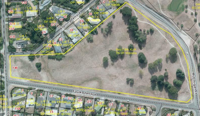
3 1. INTRODUCTION This Reserve Management Plan (plan) provides a vision for the following Recreation Reserves (the reserves), subject to this plan: 1. Lismore Park 2. Allenby Park 3. Kelly s Flat 4. Faulks Terrace 5. Domini Park 6. Kennedy Crescent At the time of writing this plan these reserves have been included as together they incorporate the most prominent or frequently used recreation reserves in Wanaka not covered by recent or current Reserve Management Plans, including the following plans: Pembroke Park and Bridgeman Green Reserve Management Plan Wanaka Lakefront Reserves Management Plan Wanaka Recreation Reserve (A&P Showgrounds) Management Plan This Plan supersedes the Lismore Park, Kellys Flat and Allenby Park Reserve Management Plan This Plan describes the general intentions for the use, maintenance, protection, preservation and development of the reserves, through a series of objectives and policies. The objectives and policies assist with decision making regarding development and use of the Reserves. The Reserves Act 1977 requires the Queenstown Lakes District Council (QLDC/Council) to prepare Reserve Management Plans for all land classified as Recreation Reserves under Council management or control. 2. RESERVE DESCRIPTIONS Lismore Park Recreation Reserve is upon land legally described as Part Section 90 Block IX TN of Wanaka, and comprises an area of approximately 18.5 hectares. Its boundaries are clearly defined by Plantation Road, Beaumont Street, Lismore Street, Heddich Street and the boundaries of the Hill View Place houses. Mount Aspiring College is located adjacent to Lismore Park on Plantation Road. The park is located a short walk from Ardmore Street and the Wanaka town centre. The park contains a stand of Conifers, in addition to other tree species scattered throughout the reserve. The eastern section of the reserve is the highest point, with the land falling away gently toward the lake. The glacial processes are obvious in the undulating landform, and such unmodified examples of glacial deposition are rare in an urban setting and provides a unique character. The site is frequently used for casual recreation. A portion of the reserve is leased to Bike Wanaka for the establishment of bike jumps, trails and pump tracks which are actively managed by the biking community. A frisbee disc golf course of 18 holes is established on the lower half of the site and is well used. Formal and informal tracks run through the reserve and are well used for through access associated with school travel and people walking from the urban areas to the town centre, and for recreational use. Allenby Park Community Reserve is upon land legally described as Lot 23 DP , and comprises approximately 1.6 hectares. The reserve was established in the early 2000s by Allenby Farms through the developments of the surrounding subdivision and had the dual purpose of a sports field reserve and some stormwater detention purpose that is evident by some exposed concrete drain caps. The surface of the park is well established for sports turf with the small banks around the perimeter established with a variety of exotic street trees. The reserve has been well used by formal and informal sports training and actively. Junior soccer, cricket and other codes have used the reserve for training with goal posts often in place on the park WANAKA RECREATION RESERVES PROPOSED RESERVE MANAGEMENT PLAN 3
4 for soccer. The dimensions of the field are too small for senior soccer, rugby or cricket games. The site is regularly used for informal fitness training and general recreation. It also is a regular route for walkers and runners accessing Mt Iron from the urban subdivisions. The reserve is located adjacent to Allenby Place and Rob Roy Lane, at the foot of Mount Iron. The site is predominately mown grass, with trees along the road verges and park edges. Kelly s Flat Recreation Reserve is upon land legally described as Section 93 Block XIV Lower Wanaka SD, and comprises approximately 3.5 hectares. It fronts on to Aubrey Road and Kings Drive. The Holy Family Catholic School is located on the opposite side of Aubrey Road and Wanaka primary school adjoins the reserve directly to the South. The entire site is grassed and mown and established as sports fields predominately for soccer with line markings and goal post often present. A small toilet block is located in the north west corner of the reserve. Angle parking was established on Aubrey Road to support the use of the site. Students accessing the schools often walk through the reserve. The Council has approved a lease area for the Wanaka Junior Football Club to install a changing and storage facility in the north west corner of the reserve near the existing toilets. Faulks Terrace Recreation Reserve is upon land legally described as Section 7 Block XLIX Town of Wanaka, and comprises an area of approximately 4.26 hectares. The site contains undulating terrain remnant of the terminal moraine and is established with mown grass and established trees. The site affords good views to the west over Lake Wanaka. There is limited active recreation on the site but is used informally for casual walks and dog exercise. The community surrounding value the open space amenity the site offers. Domini Park Recreation Reserve is upon land legally described as, Section 100 Block XIV Lower Wanaka SD, Section 106 Block XIV Lower Wanaka SD and Lot 111 DP The reserve is the southern end of a linear parcel of reserve land that traverses the ridge line between Anderson Road and Scurr Heights. Mature conifers are established on part of the site and a walking track extends from Aubrey Road at the northern end to Domini Park at the southern end. Domini Park has an established playground, toilets, BBQs and shelters that are well used by families for gatherings and children s parties. The playground includes a flying fox and in addition to the formal playground there is a large open area of grass surrounded by extensive plantings, which is used for informal recreation. Kennedy Crescent Recreation Reserve is upon land legally described as Lot 1 DP 9499, and comprises an area of 1.69 hectares. The reserve is rectangular in shape and bordered to the south by Stone Street, and east by Cardrona Valley Road. The west and north boundaries adjoin a variety of residential properties. A pedestrian/cycle linkage at the northwest corner connects with Kennedy Crescent. The land is reasonably flat mown grass, with a small number of mature trees. The site has very limited activity, typically comprising informal recreation by the close residents. 3. DESCRIPTION OF PRIMARY USERS AND ACTIVITIES The following descriptions are a general overview and are not exhaustive: 3.1 Lismore Park: Disc Golf, Mount Aspiring College, bike park, dog exercise, walking. 3.2 Allenby Park: Junior sport, exercise, dog exercise, running, soccer training WANAKA RECREATION RESERVES PROPOSED RESERVE MANAGEMENT PLAN 4
5 3.3 Kellys Flat: Wanaka Junior Football Club, touch rugby, running, athletics, through access. 3.4 Faulks Terrace: Walking, exercise, dog walking, picnics. 3.5 Domini Park: Playground, walking, dog exercise, petanque, social gatherings, BBQs, through access 3.6 Kennedy Crescent: Dog exercise, through access. 4. VISION, OBJECTIVES AND POLICIES 4.1 Vision The Reserves are for the enjoyment and benefit of the community and visitors, to facilitate recreation, sport, community wellbeing and green belt amenity. 4.2 Objectives The following objectives and policies will guide the management of the Reserves: The reserves accommodate appropriate activities in defined areas that enhance the communities use, access and enjoyment of the Reserves The reserves are maintained and developed in a planned manner to achieve quality open space that provides enhanced opportunities for the use and enjoyment of the community and visitors The reserves positively contribute to the character and ecology of the green belt and include specimens to enhance the distinctive autumn colours of the Wanaka area Any buildings shall support the uses of the reserve and community use of the reserve, and positively contribute to the amenity of the area The reserves are Smokefree areas. 4.3 General Policies Development Plan a) Prepare a Development Plan for each reserve, in consultation with the community that reflects the reserve specific policies set out in this management plan Signage a) Allow for signage on the reserves to identify the reserve, facilities available, and additional interpretive information. b) Allow for signage to convey a Smokefree message. c) Prohibit advertising billboards and other commercial signs (as defined in the District Plan), unless approved by Council in conjunction with a specific temporary event occurring on the same site. d) Support the establishment of a community Information hoarding associated with Kennedy Crescent Recreation Reserve Trees and Landscaping a) Ensure that trees are retained where they benefit the use and amenity of the reserves. b) Produce a tree management and succession plan for each reserve in conjunction with any Development Plan. c) Encourage the establishment of specimen trees to provide shelter (as necessary), structure and form to the reserves. Consideration can include trees that exhibit seasonal colour and flowers, or provide fruits and nuts for gathering. d) Only remove mature trees where they unduly impede the use of the reserve for recreation or sporting uses, create physical damage to infrastructure, or constitute an accepted hazard. e) Monitor and control as necessary, noxious and wilding species where the establishment and proliferation of such can have a materially detrimental effect on the use and enjoyment of the reserve or on the surrounding landscape. WANAKA RECREATION RESERVES PROPOSED RESERVE MANAGEMENT PLAN 5
6 f) Ensure that reserves are mown and maintained to a level necessary to assure the health of the turf and the ability to support the recreational and sporting uses of the reserves. g) Encourage community engagement and involvement in selecting, planting and caring for reserve plantings Irrigation a) Allow for in-ground and/or external irrigation for the grassed areas of formal sports fields in the relevant reserves. Any irrigation shall be to support sports field use where there is a demonstrated need that irrigation is necessary to meet the sporting needs of the community and to support the establishment of and care of amenity and community planting Buildings a) Allow the development of buildings, as appropriate and necessary to provide for the function and support of formal sport and recreation activities undertaken upon the reserves. Any such buildings shall first be covered by a relevant lease. b) Encourage a collaborative and non-exclusive use of buildings, so that they are available for community and sporting groups. c) Encourage building designs, colours and materials that are of a high quality and do not detract from the character or amenity of the reserve and surrounds. The input of the Wanaka Urban Design Panel will be required for any new building or redevelopment. Buildings shall be supported by landscaping to ensure that they enhance the character of the reserve. d) Where buildings are no longer being well utilised, an alternative use consistent with the objectives of the reserve should be found, or the building removed. e) Public toilets and shelters may be constructed on the reserves to meet the needs of reserve users Sports Fields a) Minimise the impact of organised sport and events on playing surfaces by defining and enforcing maintenance requirements and recovery periods. b) Maintain formalised sports fields to a premier level of service, equivalent to other comparably used sports fields in the District. This shall be incorporated into any Development Plan. c) Encourage a collaborative and non-exclusive use of sports fields, to ensure they are available for a variety of community and sporting groups. This is providing that no overuse occurs that might otherwise compromise the ground surface Lighting a) Provide adequate lighting of car parks, toilets and paths from streets to facilities to enable safe night time use where required. b) Ensure any lighting is installed in accordance with the Council s lighting policy, to reduce light glare and light spill beyond the reserve, improve the comfort and safety of reserve users, and limit night pollution of the night sky Events & Activities a) Permit the use of the reserves for sporting, cultural, community and recreational events and activities, including associated parking if ground conditions allow. b) Ensure that events and activities do not compromise the primary functions of the reserves to enable recreation and sporting opportunities, and those events and activities have contingency plans to relocate should ground conditions not be suitable. c) Prohibit the use of glass on reserve areas used for sporting activities Dogs a) Manage dogs in accordance with Council s current policy on dogs and dog control bylaws. WANAKA RECREATION RESERVES PROPOSED RESERVE MANAGEMENT PLAN 6
7 Model Aircraft and UAVs a) Prohibit the operation and take off/landing of UAV/Drones and model aircraft on (or from) the Reserves, unless otherwise specifically enabled by relevant Council policies and permissions Bookings a) Direct bookings for the reserves through the QLDC s Event Booking Coordinator Smokefree a) Ensure that the reserves are Smokefree, to encourage a Smokefree lifestyle, and send a positive message to the community Utility Services a) Permit utility services necessary for servicing the Reserve, its buildings and other buildings within it. b) Permit the placement of Council utility services where the reserve is not likely to be materially altered or permanently damaged, or the rights of the public using the reserve are permanently affected. Any areas of works will be reinstated. c) All utility services are to be placed underground unless it is impractical due to exceptional circumstances. d) Underground services shall be carefully sited with existing features, including trees, waterways and paved surfaces Furniture a) Provide park furniture such as seats, rubbish bins, barbeques, drinking fountains, fitness equipment and bicycle stands for the use, comfort and convenience of park users. The Wanaka Community Board shall be consulted and guidance sought, for any such establishment of new furniture. b) Promote park furniture that is of a localised consistent design and style within each reserve and is suitable for purpose Access a) Facilitate reasonable access to as many areas of the reserves as possible for persons with restricted mobility. b) All structures such as toilets, sports clubs and shelters shall be constructed to be accessible in accordance with the relevant New Zealand Standard. c) Any playgrounds, paths or fitness equipment shall give consideration to providing opportunities for people with limited mobility Encroachment a) Monitor and enforce reserve boundaries that adjoin residential properties, to ensure that adjacent residential properties are not encroaching into the reserve by extending their landscaping, lawn areas, structures, or using the reserve for the storage of property. 4.4 Reserve Specific Policies Lismore Park a) Retain the open space and landscape character of Lismore Park, whilst enhancing the reserve s ecological values. b) Provide for the continued use and development of the bike park in the eastern area of the reserve. Input from Council s arborist will be necessary where potential effects on trees are likely. c) Support the development of the bike park in a manner that seeks to enhance the experience of users. d) Consider a family friendly bike loop around the perimeter of the park, and ensure that cycle use areas are located and designed so that landscaping, pathways and furniture can mitigate potential conflicts with pedestrians and other park users. This can be considered under the Development Plan. WANAKA RECREATION RESERVES PROPOSED RESERVE MANAGEMENT PLAN 7
8 e) Provide for the use and enhancement of the Disc Golf course. This can include the upgrade and development of associated furniture, including signage, facilities, seating and landscaping. f) Consider improvements to the reserve that encourage recreational and sporting use by local schools, provided that the open space and character of the reserve is retained. g) Retain the largely passive nature of the park with the exception of biking activities, disc golf, and its use by local schools for low impact recreational use. h) Consider new recreational opportunities, permits and licenses where they don't conflict with existing uses and are consistent with the character of the site, i) Support the development of parking areas in road reserve areas and their connection with reserve areas i.e. fencing and accessible pathways. j) Support the presence and establishment of buildings associated with recreational and sporting uses if a community need is demonstrated to the satisfaction of the QLDC. k) Enable the ecological values of the reserve to be enhanced through native revegetation in areas to be considered by the Development Plan Kelly s Flat a) Provide for organised sport to be played at Kelly s Flat, with preference given to junior soccer. b) Enable options to expand the availability of usable areas for sporting use, including earthworks necessary to modify the topography to create level playing areas. c) Enable training lighting for sports fields, if required to meet the sporting needs of the community. Lighting design should minimise light spill or glare on adjoining residential areas. d) Support the creation of parking areas if they are necessary to support users of the reserve and do not materially diminish the recreational opportunities available on the reserve. e) Enable the establishment of soccer training aids in appropriate areas Allenby Community Park a) Support the presence and establishment of playground equipment, fitness circuit, walking and biking paths and tracks, BBQ equipment and seating and picnic shelter. b) Support improvements to the park surface as necessary to facilitate sporting and recreation uses. c) Ensure that the Development Plan considers areas to contain a playscape, various bike training stations, half court, fitness stations, pedestrian and cycle paths Faulks Terrace a) Retain the open space and landscape character of the reserve. b) Seek improved facilities to encourage further use and enjoyment of the reserve, including seating, pathways, play areas and a community barbeque area Domini Park a) Consider options to incorporate a bike track into any Development Plan. WANAKA RECREATION RESERVES PROPOSED RESERVE MANAGEMENT PLAN 8
 LISMORE PARK RECREATION RESERVE")

9 APPENDIX ONE RECREATION RESERVES (NOT TO SCALE OR PROPORTION) LISMORE PARK RECREATION RESERVE KELLY S FLAT RECREATION RESERVE WANAKA RECREATION RESERVES PROPOSED RESERVE MANAGEMENT PLAN 9


10 ALLENBY PARK RECREATION RESERVE FAULKS TERRACE RECREATION RESERVE WANAKA RECREATION RESERVES PROPOSED RESERVE MANAGEMENT PLAN 10


11 DOMINI PARK RECREATION RESERVE KENNEDY CRESCENT RECREATION RESERVE WANAKA RECREATION RESERVES PROPOSED RESERVE MANAGEMENT PLAN 11
LISMORE PARK, KELLYS FLAT AND ALLENBY PARK MANAGEMENT PLAN
 LISMORE PARK, KELLYS FLAT AND ALLENBY PARK MANAGEMENT PLAN 3 Process for preparing a reserve management plan in accordance with the Reserves Act 1977. 5 October 2006 Board approves developing plan 13 April
8.3 Sector 4 Brooklyn Hills
 8.3 Sector 4 Brooklyn Hills Wellington Town Belt on the Brooklyn Hills between Mt Cook and Brooklyn 8.4.1 Character and use This sector extends around the city-facing slopes below Brooklyn, from Mortimer
Seven Creeks Neighbourhood. Community Plan
 Seven Creeks Neighbourhood Community Plan INTRODUCTION SEVEN CREEKS The Seven Creeks Estate is home to a steadily expanding community of families, couples and individuals who enjoy the very best of both
8.2 Sector 2 Kelburn Park
 8.2 Sector 2 Kelburn Park Kelburn Park, near Victoria University 8.2.1 Character and use Kelburn Park is a sector of the Town Belt, of a scale and character more like a suburban park. However, the woodland
Implementation plan. 3.1 Staging
 3 Implementation plan 3.1 Staging The Olympic Park Master Plan has been developed to provide actions that are practical and realistic and considers the financial responsibilities and capacity of Council
SECTION ONE North East Industrial Zone Design Guide Palmerston North City Council June 2004
 SECTION ONE North East Industrial Zone Design Guide Palmerston North City Council June 2004 young heart easy living 1 Preface Industrial areas are a very important component of the economic well-being
11.3 SPECIAL CHARACTER ZONE HAWKE S BAY REGIONAL SPORTS PARK
 11.3 SPECIAL CHARACTER ZONE HAWKE S BAY REGIONAL SPORTS PARK 11.3.1 INTRODUCTION The availability of sports and recreation activities and facilities is important for the maintenance and enhancement of
8.8 Sector 8 Hataitai Park
 8.8 Sector 8 Hataitai Park The recreation hub at Hataitai Park Note Badminton Hall at the top of picture and Velodrome at bottom centre. 8.8.1 Character and use The sector occupies the east face of the
Throughout. square. (Crystal City Vision Plan 2050)
") 1: Terms related to the PSMP document 1 public space (see also public realm, civic space) An open space designated on the regulating plan, accessible to all, including Plazas, Mini Parks, and Neighborhoods
1: Terms related to the PSMP document 1 public space (see also public realm, civic space) An open space designated on the regulating plan, accessible to all, including Plazas, Mini Parks, and Neighborhoods
QUEENSTOWN LAKES DISTRICT COUNCIL SUBDIVISION DESIGN GUIDELINES
 Attachment C: Draft QLDC Subdivision Design Guidelines QUEENSTOWN LAKES DISTRICT COUNCIL DESIGN GUIDELINES A DESIGN GUIDE FOR AND DEVELOPMENT IN THE URBAN ZONES QUEENSTOWN OFFICE 10 Gorge Road Queenstown
QLDC PROPOSED DISTRICT PLAN [PART FIVE] NOVEMBER 2017 OPEN SPACE & RECREATION
![QLDC PROPOSED DISTRICT PLAN [PART FIVE] NOVEMBER 2017 OPEN SPACE & RECREATION](/thumbs/89/100753530.jpg "QLDC PROPOSED DISTRICT PLAN [PART FIVE] NOVEMBER 2017 OPEN SPACE & RECREATION") 38 QLDC PROPOSED DISTRICT PLAN [PART FIVE] NOVEMBER 2017 38 O P E N S PA C E & R E C R E AT I O N OPEN SPACE & RECREATION QLDC PROPOSED DISTRICT PLAN [PART FIVE] NOVEMBER 2017 38 OPEN SPACE & RECREATION
38 QLDC PROPOSED DISTRICT PLAN [PART FIVE] NOVEMBER 2017 38 O P E N S PA C E & R E C R E AT I O N OPEN SPACE & RECREATION QLDC PROPOSED DISTRICT PLAN [PART FIVE] NOVEMBER 2017 38 OPEN SPACE & RECREATION
CANOPY AT AMSTEL (THE AMSTEL GOLF COURSE REDEVELOPMENT)
") CANOPY AT AMSTEL (THE AMSTEL GOLF COURSE REDEVELOPMENT) 1000 CRANBOURNE FRANKSTON ROAD, CRANBOURNE The former Amstel Golf Course was rezoned to a General Residential Zone in 2015 to facilitate its redevelopment
CANOPY AT AMSTEL (THE AMSTEL GOLF COURSE REDEVELOPMENT) 1000 CRANBOURNE FRANKSTON ROAD, CRANBOURNE The former Amstel Golf Course was rezoned to a General Residential Zone in 2015 to facilitate its redevelopment
Appendix H: Easement cross sections
 Appendix H: Easement cross sections SHARED PATH 1.5m FOOTPATH NATURE STRIP 7.3m CARRIAGEWAY 2.7m NATURE STRIP EXISTING PIPELINE 150mm DIA 5.0m (approx.) LOCAL ACCESS ROAD EXISTING PIPELINE 500mm DIA 2.7m
PCAL Case Study Open Spaces: Blayney Heritage Park
 PCAL Case Study Open Spaces: Blayney Heritage Park Introduction Blayney Heritage Park is an area of high quality open space that offers a range of active and passive recreation facilities. The multi-purpose
GREENBANK DEVELOPMENT MASTERPLAN
 DEVELOPMENT MASTERPLAN POTENTIAL TRAIN STATION COMMUNITY CENTRE Greenbank will be a connected masterplanned community providing easy access to local and surrounding amenity. Affordable quality homes, green
Khandallah, Broadmeadows, Ngaio, Crofton Downs and Kaiwharawhara
 3 Management sector plans 3.1 Sector 1 Khandallah, Broadmeadows, Ngaio, Crofton Downs and Kaiwharawhara A unique feature of this sector is the harbour escarpment and the steep gullies off Onslow Road and
Section 6A 6A Purpose of the Natural Features and Landscapes Provisions
 Section 6A 6A Purpose of the Natural Features and Landscapes Provisions This Chapter addresses the protection and management of natural features and landscapes within the City. The City has a number of
master plan hodge park
 KCMO Parks & Commissioners Recreation Board of Parks & Recreation Kansas City, Missouri Mark McHenry Director Heather Runkel Project Manager LAND3 Studio L.L.C. Bob G Bushyhead Principle Michael H Malyn
STRATEGIC DIRECTION. QLDC PROPOSED DISTRICT PLAN [PART TWO] DECISIONS VERSION 3 strategic direction
![STRATEGIC DIRECTION. QLDC PROPOSED DISTRICT PLAN [PART TWO] DECISIONS VERSION 3 strategic direction](/thumbs/79/79711764.jpg "STRATEGIC DIRECTION. QLDC PROPOSED DISTRICT PLAN [PART TWO] DECISIONS VERSION 3 strategic direction") 3 STRATEGIC DIRECTION QLDC PROPOSED DISTRICT PLAN [PART TWO] DECISIONS VERSION 3 strategic direction QLDC DISTRICT PLAN [PART TWO] AUGUST 2015 3 strategic direction 3.1 Purpose This chapter sets out the
3 STRATEGIC DIRECTION QLDC PROPOSED DISTRICT PLAN [PART TWO] DECISIONS VERSION 3 strategic direction QLDC DISTRICT PLAN [PART TWO] AUGUST 2015 3 strategic direction 3.1 Purpose This chapter sets out the
GIBBSTON CHARACTER ZONE. QLDC PROPOSED DISTRICT PLAN [PART FOUR] AUGUST gibbston character zone
![GIBBSTON CHARACTER ZONE. QLDC PROPOSED DISTRICT PLAN [PART FOUR] AUGUST gibbston character zone](/thumbs/75/72573993.jpg "GIBBSTON CHARACTER ZONE. QLDC PROPOSED DISTRICT PLAN [PART FOUR] AUGUST gibbston character zone") 23 GIBBSTON CHARACTER ZONE QLDC PROPOSED DISTRICT PLAN [PART FOUR] AUGUST 2015 23 gibbston character zone QLDC PROPOSED DISTRICT PLAN [PART FOUR] AUGUST 2015 23 gibbston character zone 23.1 Zone Purpose
23 GIBBSTON CHARACTER ZONE QLDC PROPOSED DISTRICT PLAN [PART FOUR] AUGUST 2015 23 gibbston character zone QLDC PROPOSED DISTRICT PLAN [PART FOUR] AUGUST 2015 23 gibbston character zone 23.1 Zone Purpose
Draft Ada Street Cardiff Area Plan
 Draft Ada Street Cardiff Area Plan (Draft Amendment to Lake Macquarie Development Control Plan 2014) Exhibition: The draft Area Plan is on public exhibition from 29 February 2016 to 29 March 2016. Submissions:
Long Branch-Wayne Local Park Renovation Project
 Montgomery Parks Long Branch-Wayne Local Park Renovation Project Community Meeting #2 September 20, 2016 Oak View Elementary School 7:00-9:00 PM Welcome / Team Introductions M-NCPPC (Montgomery Parks)
97 Lea Bridge Road, Leyton, E10 7QL London Borough of Waltham Forest December 2015
 97 Lea Bridge Road, Leyton, E10 7QL London Borough of Waltham Forest December 2015 Public Realm and Landscape Proposals LEA BRIDGE ROAD, WALTHAMSTOW Public Realm & Landscape Proposals BDP(90)RPT001 December
Charles P. Johnson and Associates. Annapolis Landscape Architects
 Charles P. Johnson and Associates Annapolis Landscape Architects AGENDA Introduction Project Limits and Scope Site Analysis Opportunities & Constraints Program Goals Image Boards Design Alternatives Pros
Ensure that development within the Arrowtown Urban Growth Boundary provides:
 URBAN DEVELOPMENT 4 4.2.5.2 Ensure that development within the Arrowtown Urban Growth Boundary provides: an urban form that is sympathetic to the character of Arrowtown, including its scale, density, layout
REFERENCE: 16/8568/ENQ Received: 25 October 2016 Accepted: 26 October 2016
 LOCATION: Allianz Park, Greenlands Lane, London, NW4 1RL REFERENCE: 16/8568/ENQ Received: 25 October 2016 Accepted: 26 October 2016 WARD(S): Mill Hill APPLICANT: Saracens Copthall Ltd. PROPOSAL: Extension
GREENVALE CENTRAL PRECINCT STRUCTURE PLAN
 76 Conservation area boundary. Low Fence to exclude vehicles but allow pedestrian access Front boundary of allotment 5.0m MINIMUM SETBACK Path providing public access to dwellings fronting Conservation
H7 Open Space zones. (a) provide for the needs of the wider community as well as the needs of the community in which they are located;
 provide for the needs of the wider community as well as the needs of the community in which they are located;") H7. Open Space zones H7.1. Background The majority of land zoned as open space is vested in the Council or is owned by the Crown. However some areas zoned open space are privately owned. While the open
H7. Open Space zones H7.1. Background The majority of land zoned as open space is vested in the Council or is owned by the Crown. However some areas zoned open space are privately owned. While the open
VICTORIA PARK / BAKKABAKKANDI COMMUNITY RECREATION PARK CONCEPT MASTER PLAN. November 2008
 CONCEPT MASTER PLAN November 2008 EXECUTIVE SUMMARY Concept Master Plan Summary Concept Master Plan Outline Plan Concept Master Plan Perspectives SECTION ONE - BACKGROUND Context Existing Site Existing
6 Landsc apes and rur al char ac
 LANDSCAPES AND RURAL CHARACTER QLDC PROPOSED DISTRICT PLAN [PART TWO] DECISION VERSION ter 6 Landsc apes and rur al char ac 6.1 Purpose Appendix C QLDC DISTRICT PLAN [PART TWO] DECISION VERSION 6 Landsc
SUFFOLK PARK COMMUNITY PARK MASTERPLAN a place for the community
 SUFFOLK PARK COMMUNITY PARK MASTERPLAN a place for the counity March 218 PARK & CONTEXT critical public open space for the counity BROKEN HEAD RD LAKE PARK ESCARPMENT BEECH DR SUFFOLK PARK VILLAGE CENTER
USE OF CITY PARKS AND PAVED TRAILS POLICY
 CITY OF WHITEHORSE COUNCIL POLICY POLICY: PURPOSE: USE OF CITY PARKS AND PAVED TRAILS To legitimize and manage commercial use and temporary bookable private use of City parks and paved trails without over-encumbering
RECREATION AND OPEN SPACE ELEMENT GOALS, OBJECTIVES, AND POLICIES
 RECREATION AND OPEN SPACE ELEMENT GOALS, OBJECTIVES, AND POLICIES Goal 7 To provide park facilities, recreation programs, and open space resources that are safe, adequate, and accessible to all City residents,
URBAN DEVELOPMENT QLDC PROPOSED DISTRICT PLAN [PART TWO] AUGUST 2015
![URBAN DEVELOPMENT QLDC PROPOSED DISTRICT PLAN [PART TWO] AUGUST 2015](/thumbs/80/81778199.jpg "URBAN DEVELOPMENT QLDC PROPOSED DISTRICT PLAN [PART TWO] AUGUST 2015") 4 URBAN VLOPMNT U R P QLC PROPO ITRICT PLAN [PART TWO] AUGUT 2015 4 ur b an de v elop ment QLC ITRICT PLAN [PART TWO] AUGUT 2015 4 urban development 4 2 4.1 Purpose The purpose of this Chapter is to set
4 URBAN VLOPMNT U R P QLC PROPO ITRICT PLAN [PART TWO] AUGUT 2015 4 ur b an de v elop ment QLC ITRICT PLAN [PART TWO] AUGUT 2015 4 urban development 4 2 4.1 Purpose The purpose of this Chapter is to set
10.0 Open Space and Public Realm
 10.0 Open Space and Public Realm 10.0 Open Space and Public Realm The Public Open Space System is comprised of: outdoor spaces available for public use that are either publicly owned (e.g., parks and
UNIVERSITY TOWN NEIGHBOURHOODS 5.2 ECO-CORRIDOR MELBOURNE CAMPUS MASTER PLAN 2014
 5.2 ECO-CORRIDOR 37 ECO-CORRIDOR EXISTING CONDITIONS & VISION NEIGHBOURHOOD VISION Investment in the Eco-corridor Neighbourhood will signify the University s commitment to supporting local ecology and
I539. Smales 2 Precinct
 I539. Smales 2 Precinct I539.1. Precinct Description The Smales 2 Precinct applies to a 4.8 hectare block of land located on the southern side of Northcote Road and fronting Lake Pupuke, Takapuna. The
Appendix E Section 4(f) Evaluation
 Evaluation") Appendix E Section 4(f) Evaluation Appendix E Draft Section 4(f) Evaluation E.1 Introduction This appendix addresses a federal regulation known as Section 4(f), which protects parks, recreation areas,
Appendix E Section 4(f) Evaluation Appendix E Draft Section 4(f) Evaluation E.1 Introduction This appendix addresses a federal regulation known as Section 4(f), which protects parks, recreation areas,
CONTENTS. Reserve Management Plan Playford Park
 PREFACE Located in the heart of Levin s urban area, Playford Park is an important and valuable open space and recreation area for both the town of Levin and the Horowhenua District. As such the review
Community Visioning Workshop Prep
 Community Visioning Workshop Prep Visioning Workshop 73 Visioning Workshop: Public Events 1 2 3 4 74 Visioning Workshop: draft Schedule 75 Visioning Workshop: draft Schedule working to schedule stakeholder
COMMUNITY DESIGN. GOAL: Create livable and attractive communities. Intent
 COMMUNITY DESIGN Intent An attractive, well-designed County will attract quality development, instill civic pride, improve the visual character of the community, and create a strong, positive image for
URBAN DESIGN BRIEF. 2136&2148 Trafalgar Road. Town of Oakville
 URBAN DESIGN BRIEF 2136&2148 Trafalgar Road Town of Oakville Prepared By: METROPOLITAN CONSULTING INC For 2500674 Ontario Inc November 2016 TABLE OF CONTENTS Page No. 1.0 Introduction/Description of Subject
Gas Stations ottawa.ca
 Urban Design Guidelines for Gas Stations ottawa.ca Ce document est disponible en français sur ottawa.ca. This document is available in French on ottawa.ca. Approved by City Council May 24, 2006 City of
SCHEDULE THREE TO THE DEVELOPMENT PLAN OVERLAY EASTERN GOLF COURSE KEY REDEVELOPMENT SITE
 DD/MM/YY SCHEDULE THREE TO THE DEVELOPMENT PLAN OVERLAY Shown on the planning scheme map as DPO3 EASTERN GOLF COURSE KEY REDEVELOPMENT SITE 1.0 A permit may be granted before a development plan has been
City of Los Angeles Department of Public Works
 City of Los Angeles Department of Public Works Environmental Scoping Meeting for the Proposed Sixth Street Park, Arts, River & Connectivity Improvements (PARC) Project May 3, 2017 1 Agenda Introductions
I309. Cornwall Park Precinct
 I309. Cornwall Park Precinct I309.1. Precinct Description Cornwall Park is a privately owned and managed landscaped park designed for public recreation and enjoyment and is a highly used and valued open
Appendix A - Relief sought
 Appendix A - Relief sought Chapter 2 Definitions Definitions Tourism Activity (new) and Visitor Industry (new) The plan does not provide specific definition for tourism. The plan does introduce a new strategic
3. STATEMENTS OF DESIRED CHARACTER FOR PLANNING AREAS AND PRECINCTS
 3.30 Planning Area No. 30 Mary River Valley 3.30.1 Location and Role This Planning Area encompasses rural lands in the western part of the Shire. These lands are located within the catchment area of the
PART 05 VISUAL SETTING
 PART 05 VISUAL SETTING 5.1 How to use the Visual Settings 5.2 Views from the Headland 5.3 Creek Foreshore Park Looking North 5.4 Bridge looking North 5.5 Bridge looking West 5.6 Bridge looking South 5.7
Urban Growth Boundaries
 Urban Growth Boundaries Discussion Document July 2008 Contents page Introduction... 3 What are urban growth boundaries?... 3 The need to manage growth... 3 Purpose of urban growth boundaries... 4 How will
BROOKHILL NEIGHBORHOOD MODEL ZONING MAP AMENDMENT PREFACE TO APPLICATION
 BROOKHILL NEIGHBORHOOD MODEL ZONING MAP AMENDMENT PREFACE TO APPLICATION June 15, 2015 Revised: August 1, 2016 I. VISION Brookhill is a proposed community based upon the principles of Albemarle County
North Oakville East Parks Facilities Distribution Plan. November, 2009
 North Oakville East November, 2009 POLICY CONTEXT 1) Purpose a) The purpose of this document is to be a guide for the location, configuration, design and development of the parks system for the North Oakville
Division 13 Local Business and Industry Buffer Zone: Assessment Criteria and Assessment Tables
 Division 13 Local Business and Industry Buffer Zone: Assessment Criteria and Assessment Tables 4.13.1 Local Business and Industry Buffer Zone The provisions in this division relate to the Local Business
4. Parks, Open Space and Urban Forest
 4. Parks, Open Space and Urban Forest Goals 1. Enhance parks as public gathering places for the neighbourhood 2. Refresh park facilities to attract diverse ages and activities 3. Improve waterfront access
4 RESIDENTIAL ZONE. 4.1 Background
 4 RESIDENTIAL ZONE 4.1 Background The residential areas within the City are characterised by mainly lowrise dwellings sited on individual allotments. Past architectural styles, settlement patterns and
Colchester Northern Gateway Master Plan Vision Review Draft. July 2016
 Colchester Northern Gateway Master Plan Vision Review Draft July 2016 Contents Introduction 4 Context 8 Purpose of the Report 8 Strategic Position 9 Overview of the Process 11 2012 Master Plan Vision 12
CALA HO ME S WELCOME
 WELCOME Welcome to this public consultation event for our proposed residential development of 56 high quality homes on land to the north east of Station Road in Earls Colne. Thank you for taking the time
BISCUIT RUN PARK MASTER PLAN
 BOARD OF SUPERVISORS November 14, 2018 BISCUIT RUN PARK MASTER PLAN COUNTY OF ALBEMARLE ANHOLD ASSOCIATES Contents Project Introduction Property Background County Park Planning Process Existing Site &
BYLAW C A Bylaw of Rocky View County to amend Land Use Bylaw C
 BYLAW C-7720-2017 A Bylaw of Rocky View County to amend Land Use Bylaw C-4841-97. The Council of Rocky View County enacts as follows: PART 1 TITLE This Bylaw shall be known as Bylaw C-7720-2017. PART 2
QLDC PROPOSED DISTRICT PLAN [PART FIVE] AUGUST 2015 SUBDIVISION & DEVELOPMENT
![QLDC PROPOSED DISTRICT PLAN [PART FIVE] AUGUST 2015 SUBDIVISION & DEVELOPMENT](/thumbs/96/128451269.jpg "QLDC PROPOSED DISTRICT PLAN [PART FIVE] AUGUST 2015 SUBDIVISION & DEVELOPMENT") 27 QLDC PROPOSED DISTRICT PLAN [PART FIVE] AUGUST 2015 27 S ub division & D evelopment SUBDIVISION & DEVELOPMENT 27.1 Purpose Subdivision and the resultant development enables the creation of new housing
27 QLDC PROPOSED DISTRICT PLAN [PART FIVE] AUGUST 2015 27 S ub division & D evelopment SUBDIVISION & DEVELOPMENT 27.1 Purpose Subdivision and the resultant development enables the creation of new housing
CHAPPLES PARK MASTER PLAN. Presentation to Council April 10, 2017
 CHAPPLES PARK MASTER PLAN Presentation to Council April 10, 2017 1 PRESENTATION AGENDA 1. Project Background, Aim and Process 2. The Site Issues and Opportunities 3. Community Engagement 4. Vision and
Draft Master Plan for Franklin Park
 Draft Master Plan for Franklin Park Metro Parks Tacoma with SiteWorkshop November 2009 I. overview & background Process & History Master Plan Process The Master Plan is based on a community involvement
Longbridge Town Centre Phase 2 Planning Application
 Longbridge Town Centre Phase 2 Planning Application Non-Technical Summary of the Environmental Statement December 2013 Introduction A full application for Planning Permission has been submitted to Birmingham
4 Residential and Urban Living Zones
 4 Residential and Urban Living Zones Refer to Chapters 11 to 20 for additional rules that may apply to these zones. 4.1 OBJECTIVES AND POLICIES Objective Res1 Policy 1 Policy 2 Policy 3 Policy 4 Policy
Riverwalk Dreams compiled by Thomas P. Healy November 16, 2017
 Riverwalk Dreams compiled by Thomas P. Healy November 16, 2017 1986 Ripple Village Plan: A neighborhood plan developed by the City of Indianapolis Department of Metropolitan Development s Division of Planning
Overview Report. Proposed Development
 Overview Report Proposed Development the construction of a 1km cycle/pedestrian trail including a new footbridge, new car park and entrance road at Drumshanbo Lock and a new pedestrian/cycle road crossing,
Section Three, Appendix 17C Multiple Unit Housing Design Assessment Criteria
 APPENDIX 17C MULTIPLE UNIT HOUSING DESIGN ASSESSMENT CRITERIA Purpose of Appendix 17C In the Residential 9 Zone the construction and use of multiple household units located within the Multiple Household
M E M O R A N D U M February 21, 2018
 M E M O R A N D U M February 21, 2018 Project: Action Requested: Background Information: CP18-001, Ordinance No. 1060-A, Amendment to the City of Southlake Parks, Recreation & Open Space / Community Facilities
Introduction. Welcome to this consultation regarding the draft redevelopment proposals for the former CeramTec factory on Sidmouth Road, Colyton.
 Introduction Welcome to this consultation regarding the draft redevelopment proposals for the former CeramTec factory on Sidmouth Road, Colyton. We are currently considering options for the mixed-use redevelopment
open space environment
 This section updated August 09 GUIDELINE TO THE RULES The Open Space Environment Rules apply to activities on sites within the Open Space Environment as shown on the Human Environments Maps. Most of the
To secure a Green Belt around Cambridge whose boundaries are clearly defined and which will endure for the plan period and beyond.
 4. GREEN BELT OBJECTIVES GB/a GB/b GB/c GB/d To secure a Green Belt around Cambridge whose boundaries are clearly defined and which will endure for the plan period and beyond. To maintain the purposes
6 Site Framework Strategies
 6 Site Framework Strategies 6.1 Introduction Section 6 identifies a number of specific areas which are considered to be key sites within the Plan area and which may have potential for development / redevelopment.
2. reimagine kings way undercroft as a community space
 2. reimagine kings way undercroft as a community space CLARENDON STREET CLARKE STREET QUEENS BRIDGE STREET MORAY STREET CITY ROAD BALSTON STREET BOYD KINGS WAY POWER STREET KAVANAGH WEST GATE FREEWAY Figure
Standards (R-3) Figure B-11: R-3 Residential Standards Exhibit
 Figure B-11: R-3 Residential Standards Exhibit") Avila Ranch Avila Ranch Specific Plan Development Standards High Medium Density - High Residential Density Residential Lot and Building Lot and Standards Building (R-3) Standards (R-3) EXAMPLES These sketches
Avila Ranch Avila Ranch Specific Plan Development Standards High Medium Density - High Residential Density Residential Lot and Building Lot and Standards Building (R-3) Standards (R-3) EXAMPLES These sketches
ANCHORAGE PARK REPORT CARD Assessing A Park s Appearance, Function, & Condition
 ANCHORAGE PARK REPORT CARD Assessing A Park s Appearance, Function, & Condition Park Name: Is Your Park an A or an F? Your Name: Contact Information Optional: Date: General Instructions: Phone: Email:
THREE KINGS RENEWAL DESCRIPTION OF URBAN DESIGN / ARCHITECTURAL ELEMENTS AND PROCESS. prepared by dko Architecture
 THREE KINGS RENEWAL DESCRIPTION OF URBAN DESIGN / ARCHITECTURAL ELEMENTS AND PROCESS prepared by dko Architecture THESE PLANS OUTLINE THE VISION OF FLETCHER RESIDENTIAL LTD AND ARE NOT ENDORSED BY AUCKLAND
BLACKHEATH SQUASH CLUB Blackheath Sports Club, Rectory Field, Charlton Road, London, SE7 7EY. Planning, Design and Access Statement
 Planning, Design and Access Statement Revised: 28 th Jan 2016 Peter Pendleton & Associates Ltd Introduction Planning permission will be sought for a refurbishment of existing courts and extension to provide
Mixed Use Centres Development Permit Guidelines
 1 Mixed Use Centres Development Permit Guidelines Area Commercial or Mixed Use development occurring in City Centre, Urban Centre, Neighbourhood Centre, or Institutional Complex land use designations is
Neighbourhood Planning Local Green Spaces
 Neighbourhood Planning Local Green Spaces Introduction... 2 1. Why green space is important... 4 2. Neighbourhood plans and green space... 6 3. Evidence... 8 Statutory designations... 9 Green space audit...
APPENDIX C Township 9 Consistency with Applicable Plans
 Township 9 Consistency with Applicable Plans 1985 American River Parkway Plan Policies Project Consistency Policy 4.14: The following activities and facilities, which are incompatible with the Parkway,
This table identifies new provisions sought to be added:
 Chapter 16 Business Mixed Use This table identifies new provisions sought to be added: Appellant Court Number FII Holdings Limited ENV-2018-CHC-084 FII Holdings Limited ENV-2018-CHC-084 Universal Developments
The open space system should provide connective elements, relate to natural resources, and enhance the suburban character of the landscape..
 The open space system should provide connective elements, relate to natural resources, and enhance the suburban character of the landscape.. Mixed-use and infill development should maintain or enhance
FORMER CANADIAN FORCES BASE (CFB) ROCKCLIFFE SECONDARY PLAN. Official Plan Amendment XX to the Official Plan for the City of Ottawa
 ROCKCLIFFE SECONDARY PLAN. Official Plan Amendment XX to the Official Plan for the City of Ottawa") FORMER CANADIAN FORCES BASE (CFB) ROCKCLIFFE SECONDARY PLAN Official Plan Amendment XX to the Official Plan for the City of Ottawa 1 INDEX THE STATEMENT OF COMPONENTS PART A THE PREAMBLE PAGE Purpose...
FORMER CANADIAN FORCES BASE (CFB) ROCKCLIFFE SECONDARY PLAN Official Plan Amendment XX to the Official Plan for the City of Ottawa 1 INDEX THE STATEMENT OF COMPONENTS PART A THE PREAMBLE PAGE Purpose...
Las Colonias Park Master Plan
 2013 Las Colonias Park Master Plan City of Grand Junction June 2013 Introduction Las Colonias Park, a 101 acre parcel on the edge of the Colorado River south of downtown, was deeded to the City of Grand
SPG 1. * the northern and western sections which are open fields used for pasture and grazing;
 SPG 1 1.0 INTRODUCTION This development brief is based on the allocation of the Priors Hall site for employment and countryside recreational purposes in the Corby Borough Local Plan. The brief is intended
RURAL ZONE - POLICY. Rural Zone Policy. Issue: Rural Environment. Ruapehu District Plan Page 1 of 8
 Rural Zone Policy RU2 RURAL ZONE - POLICY RU2.1 Introduction The natural resources of the rural environment in the Ruapehu District provide the basis for the existing and potential character, intensity
The following principles guide the development of goals and strategies to protect and promote these amenities:
 OPEN SPACE/PARKS/TRAILS/RECREATION GOALS/STRATEGIES Cherry Hills Village is a living environment that offers low density development, open areas, public scenic vistas, public trails and public parks. This
Rural (Urban Expansion) Environment
 Environment") RUEE.1 Rural (Urban Expansion) Environment Subsequent to the receipt of appeals, a 'marked up' version of the Proposed District Plan was prepared. The provisions of the Proposed Version of the Plan subject
RUEE.1 Rural (Urban Expansion) Environment Subsequent to the receipt of appeals, a 'marked up' version of the Proposed District Plan was prepared. The provisions of the Proposed Version of the Plan subject
Open Space and Recreational Resources
 Chapter 3: Open Space and Recreational Resources A. INTRODUCTION Under the 2012 City Environmental Quality Review (CEQR) Technical Manual guidelines, open space is defined as publicly accessible, publicly
Ashtead Neighbourhood Forum Site Assessment AS14 Land at The Pines, Farm Lane. Site ref: AS14 Site address: Land at The Pines, Farm Lane
 Site ref: AS14 Site address: Land at The Pines, Farm Lane Proposed Land Use: Total Site Area (Ha): Housing 2.1ha Description: The site is located to the east of Ashtead off Farm Lane and is currently grassed.
CHAPPLES PARK MASTER PLAN
 CHAPPLES PARK MASTER PLAN Presentation of Preliminary Development Options Public Open House #2 Wednesday November 2 nd, 2016 TONIGHT S AGENDA 1. Welcome & Introductions 2. Presentation by Sierra Planning
KASPER. City of Georgetown, Texas PUD Planned Unit Development. December 30, 2015 Revised January 27, 2016
 KASPER City of Georgetown, Texas PUD Planned Unit Development December 30, 2015 Revised January 27, 2016 Applicant: Sentinel Land Company, LLC 4910 Campus Drive Newport Beach, CA Prepared by: SEC Planning
Tāhuhu whakaruruhau ā-taone The sheltering ridge pole
 B2. Tāhuhu whakaruruhau ā-taone - Urban growth and form B2.1. Issues Tāhuhu whakaruruhau ā-taone The sheltering ridge pole Auckland s growing population increases demand for housing, employment, business,
Chapter 6. Overall Vision RECOMMENDATIONS. More Trail and Trail. Connections. Equal Access to Park. Facilities and Programs. Water Access.
 Overall Vision More Trail and Trail Connections Equal Access to Park Facilities and Programs Water Access Environment Variety Chapter 6 RECOMMENDATIONS Chapter 6 The following recommendations for park,
QLDC PROPOSED DISTRICT PLAN [PART SIX] DECISIONS VERSION 42 waterfall park
![QLDC PROPOSED DISTRICT PLAN [PART SIX] DECISIONS VERSION 42 waterfall park](/thumbs/96/126991214.jpg "QLDC PROPOSED DISTRICT PLAN [PART SIX] DECISIONS VERSION 42 waterfall park") 42 WATERFALL PARK 42.1 Purpose The purpose of the Waterfall Park Zone is to provide for the development of a visitor resort comprising a range of visitor, residential and recreational facilities, sympathetic
42 WATERFALL PARK 42.1 Purpose The purpose of the Waterfall Park Zone is to provide for the development of a visitor resort comprising a range of visitor, residential and recreational facilities, sympathetic
Place Brief. National Collections Facility (NCF site)
") Place Brief. National Collections Facility (NCF site) Contents 1.0 Purpose 2.0 Location and Proposal 3.0 Vision and Aim 4.0 Placemaking Principles 5.0 Conclusion Plan 1 Location Plan Plan 2 Placemaking
Place Brief. National Collections Facility (NCF site) Contents 1.0 Purpose 2.0 Location and Proposal 3.0 Vision and Aim 4.0 Placemaking Principles 5.0 Conclusion Plan 1 Location Plan Plan 2 Placemaking
RESIDENTIAL. QLDC PROPOSED DISTRICT PLAN [PART THREE] DECISIONS VERSION 8 medium density residential
![RESIDENTIAL. QLDC PROPOSED DISTRICT PLAN [PART THREE] DECISIONS VERSION 8 medium density residential](/thumbs/84/89275880.jpg "RESIDENTIAL. QLDC PROPOSED DISTRICT PLAN [PART THREE] DECISIONS VERSION 8 medium density residential") 8 MEDIUM DENSITY RESIDENTIAL QLDC PROPOSED DISTRICT PLAN [PART THREE] DECISIONS VERSION 8 medium density residential QLDC PROPOSED DISTRICT PLAN [PART THREE] DECISIONS VERSION 8 medium density residential
8 MEDIUM DENSITY RESIDENTIAL QLDC PROPOSED DISTRICT PLAN [PART THREE] DECISIONS VERSION 8 medium density residential QLDC PROPOSED DISTRICT PLAN [PART THREE] DECISIONS VERSION 8 medium density residential
Section 3b: Objectives and Policies Rural Environment Updated 19 November 2010
 Page 1 of Section 3b 3b RURAL ENVIRONMENT 3b.1 Introduction The Rural Environment comprises all the land outside of the Residential, Town Centre and Industrial Environments. Most land within the District
doyle + o troithigh landscape - architecture
 doyle + o troithigh landscape - architecture REPORT: PROJECT: LANDSCAPE DESIGN REPORT. STUDENT HOUSING DEVELOPMENT AT WESTWOOD HOTEL SITE. DATE: MAY 2018. www.doyle-otroithigh.com Landscape design report,
Test Valley Borough Council Southern Area Planning Committee 8 January 2019
 ITEM 11 APPLICATION NO. 18/02218/FULLS APPLICATION TYPE FULL APPLICATION - SOUTH REGISTERED 23.08.2018 APPLICANT Rugby Football Union SITE The Trojans Club, Stoneham Lane, Eastleigh, SO50 9HT, CHILWORTH