Planning scheme policy for Palmview Structure Plan
|
|
|
- Oscar Underwood
- 5 years ago
- Views:
Transcription
1 SC6.20 Planning scheme policy for Palmview Structure Plan Formatted: Indent: Hanging: 3.5 cm SC Preliminary Purpose (1) The purpose of this planning scheme policy is to:- (b) (c) state standards identified in the Palmview structure plan area code; provide guidelines and advice about satisfying assessment criteria in the Palmview Structure Plan; and state the additional information which the Council may request in respect of a development application. Application (2) This planning scheme policy applies to a development application for a preliminary approval to which section 242 of the Act applies or a development application for assessable development in the Master Planned Area. (3) The provisions of the Planning scheme policy for the Palmview Structure Plan prevail over the provisions of any other planning scheme policy to the extent of any inconsistency;. Relationship to Palmview Structure Plan (4) This planning scheme policy is to be read in conjunction with the Palmview Structure Plan. Interpretation (5) Terms used in this planning scheme policy that are also used in the Palmview Structure Plan have the meaning given in the Palmview Structure Plan. SC Ecological and landscape protection outcomes Preliminary (1) This section applies to the following ecological and landscape protection outcomes:- (b) the ecological and landscape protection outcomes in Performance Outcomes PO4 to PO15 in Section (Performance outcomes and acceptable outcomes for the whole of the master planned area) of the Palmview structure plan area code; and the non-urban open space infrastructure network outcomes in Performance Outcomes P045 P03840 to P049 P04244 in Section (Performance outcomes and acceptable outcomes for the Development of Infrastructure and Services) of the Palmview structure plan area code. General advice for ecological and landscape protection outcomes (2) The following is general advice about satisfying the ecological and landscape protection outcomes:- The ecological and landscape protection outcomes seek to ensure that the development of the Master Planned Area occurs in a manner that:- (i) (ii) (iii) appropriately recognises and responds to physical constraints; provides for the protection and rehabilitation of a significant part of the Master Planned Area for environmental and landscape protection purposes; and otherwise exhibits contemporary best practice approaches to ecological and landscape protection. (b) The ecological and landscape protection outcomes are primarily intended to be satisfied by the following:- Page SC2
2 (i) (ii) avoiding development for urban purposes, other than the limited infrastructure specified on the structure plan maps, occurring:- (i) (A) on flood prone land identified as being unsuitable to be filled for urban purposes; and (B) in an ecologically important area; (B) achieving a minimum of hectares of land for ecological protection and rehabilitation purposes to improve the extent and capability of natural systems to absorb the impacts associated with large scale urban development and increasing population pressure through the following:- (ii) (A) (B) (C) (D) the establishment of the non-urban open space infrastructure network specifically identified on Other Plans Map OPM P14 P12 (Palmview master planned area non-urban open space infrastructure network) in Schedule 2 (Mapping); the implementation of Appendix SC6.20A (Palmview master planned area ecological and landscape protection and rehabilitation plan); the implementation of a Local Ecological and Landscape Protection and Rehabilitation Plan which:- (C) 1. outlines how Appendix SC6.20A (Palmview master planned area ecological and landscape protection and rehabilitation plan) is to be achieved; 2. is to be assessed against the requirements which may include the matters in Section 10 (Requirements for local ecological protection and rehabilitation plan) of Appendix SC6.20A (Palmview master planned area ecological and landscape protection and rehabilitation plan) specified in a preliminary approval to which section 242 of the Act applies or another applicable development approval; and 3. has been approved by a compliance certificate given by the Council; 3. where the provision of infrastructure required to service development in the Master Planned Area adversely impacts on an ecologically important area, the implementation of a Environmental Offset Plan which:- (D) 1. outlines how the ecological and landscape protection outcomes for environmental offsets are to be achieved; 2. is to be assessed against the requirements specified in a preliminary approval to which section 242 of the Act applies or another applicable development approval which may include the matters in Table SC6.20H (Compliance assessment requirements); and 3. has been approved by a compliance certificate given by the Council. Formatted: Indent: Left: 3 cm, No Formatted: Indent: Left: 4 cm, No Formatted: Indent: Left: 3 cm, No Formatted: Indent: Left: 4 cm, No Formatted: Indent: Left: 5 cm, No Formatted: Indent: Left: 4 cm, No Guidelines and advice for the ecological and landscape protection outcomes (3) The Palmview master planned area ecological and landscape protection and rehabilitation plan (Appendix SC6.20A) provides for the following:- (b) guidelines about satisfying the ecological and landscape protection outcomes; and advice about the requirements for Local Ecological and Landscape Protection and Rehabilitation Plans to be required in a preliminary approval to which section 242 of the Act applies or another applicable development approval. Advice for environmental offset outcomes (4) For the purposes of Performance Outcome PO6 in Section (Performance outcomes and acceptable outcomes for the whole of the master planned area) of the Palmview structure plan area code, the following is advice about satisfying the assessment criteria in the code for the environmental offset outcomes:- the Structure Plan Maps identify which infrastructure corridors cross ecologically important areas and the approximate location of the crossings; Page SC3
3 (b) a environmental offset is required to be provided under the Palmview structure plan area code in circumstances where infrastructure required to service the Master Planned Area adversely impacts upon:- (i) (ii) an ecologically important area (either within the Master Planned Area or external to the Master Planned Area); or the ability to achieve a minimum of hectares of land for ecological protection and rehabilitation purposes; (c) infrastructure is to be considered to adversely impact upon an ecologically important area where one or more of the following occurs or is likely to occur:- (i) (ii) (iii) (iv) the clearing of native remnant or regrowth vegetation or habitat; the restriction of fauna movement or other impact upon a habitat corridor; water quality or a natural hydrological condition is affected; and the functioning of the ecologically important area is otherwise impacted upon. Advice for environmental transition area outcomes (5) For the purposes of Performance Outcome PO9 in Section (Performance Outcomes and Acceptable Outcomes for the whole of the Master Planned Area) of the Palmview structure plan area code, the following is advice about satisfying the standards in the code for the environmental transition area outcomes:- (b) (c) (d) the ecological and landscape protection outcomes provide for limited low impact activities and embellishments to occur within the environmental transition area where they can be demonstrated to be compatible with the primary ecological function of the area; a environmental offset is not required in respect of development of the environmental transition area where the development satisfies the standards in the code for the environmental transition area outcomes; further guidance in respect to stormwater infrastructure is specified in Section SC (Integrated Water Cycle Management Infrastructure Network Outcomes)the Planning scheme policy for Development works; and further guidance in respect to recreation parks is specified in Section SC (Urban Open Space Infrastructure Network Outcomes). Standards and advice for the scenic amenity and highway acoustic buffer outcomes (6) For the purposes of Performance Outcome PO10(f) in Section (Performance Outcomes and Acceptable Outcomes for the whole of the Master Planned Area) of the Palmview structure plan area code, the following are the standards in the code for the scenic amenity and highway acoustic buffer outcomes:- the scenic amenity and highway acoustic buffer is developed in accordance with the typical cross section specified in Figure SC6.20A (Scenic amenity and highway acoustic buffer typical cross section). (7) For the purposes of Performance Outcome PO10 in Section (Performance outcomes and acceptable outcomes for the whole of the mater Master planned Planned areaarea) of the Palmview structure plan area code, the following is advice about satisfying the assessment criteria in the code for the scenic amenity and highway acoustic buffer outcomes:- (b) the Palmview Master Planned Area forms an important part of the distinctive green space or intra-urban break between Caloundra and Maroochydore and is visually significant in relation to views of the Mooloolah River floodplain landscape from the Bruce Highway; and the Palmview Structure Plan provides for an 80 metre wide semi-vegetated buffer (measured from the eastern boundary of the Bruce Highway Road Corridor proposed widening) to be established along the full length of the Palmview Master Planned Area boundary to the Bruce Highway. Page SC4
4 Figure SC6.20A Scenic amenity and highway acoustic buffer typical cross section Page SC5
5 SC Neighbourhood design, housing and density outcomes Preliminary (1) This section applies to the neighbourhood design, housing and density outcomes in Performance Outcomes PO26 to PO33 in Section (Performance outcomes and acceptable outcomes for the whole of the master planned area) of the Palmview structure plan area code (neighbourhood design, housing and density outcomes). General advice for neighbourhood design, housing and density outcomes (2) The following is general advice about satisfying the neighbourhood design, housing and density outcomes:- the urban structure and land use pattern of the Palmview Master Planned Area is based on the establishment of a number of neighbourhoods which:- (i) (ii) aggregate to comprise the broader Palmview community and support the function of the Palmview District Activity Centre; and are generally defined by a walkable catchment being a five minute walk (400 metres) from an activity centre. (b) the neighbourhood design, housing and density outcomes of the Palmview structure plan area code seek to ensure that development within the Palmview Master Planned Area creates a number of neighbourhoods that:- (i) (ii) (iii) (iv) (v) (vi) (vii) (viii) (ix) (x) (xi) support sustainable urban development through maximising land efficiency; encourage alternative travel options to car based travel by promoting the attractiveness of walking, cycling and public transport and providing maximum choice for the end user; promote good access and connectivity between new neighbourhoods while providing clear connection to surrounding development; establish main street activity centres that promote walkable neighbourhoods and provision of employment; achieve lot and dwelling diversity particularly around activity centres and public transport; protect areas of environmental value and incorporate cultural, environmental and key landscape features; promote community health through the provision of a variety of public open spaces and the promotion of active transport modes; promote perimeter block development that establishes an active interface between building frontage and streets to improve personal safety through increased surveillance and activity; foster a sense of community and strengthen local identity and sense of place while catering to a range of differing lifestyles; promote environmentally sustainable urban water management; and are complete integrated communities rather than a series of housing estates. (c) the neighbourhood design, housing and density outcomes are primarily intended to be satisfied through the following:- (i) application of best practice neighbourhood design implemented through a preliminary approval to which section 242 of the Act applies or the approval of a another applicable development application; (ii) implementing an Affordable Living Plan which:- (A) outlines how the housing affordability and affordable living outcomes for the Master Planned Area are to be achieved; (B) is to be assessed against the requirements specified in a preliminary approval to which section 242 of the Act applies or another applicable development approval which may include the matters in Table SC6.20H (Compliance assessment requirements); and (C)(c) has been approved by a compliance certificate given by the Council.; Formatted: Outline numbered + Level: 2 + Numbering Style: a, b, c, + Start at: 1 + Alignment: Left + Aligned at: 1 cm + Tab after: 2 cm + Indent at: 2 cm Formatted: Font: Not Bold (d) (e) development should be designed through an integrated design approach that iteratively considers each component or network of a neighbourhood; development should provide neighbourhoods that are arranged to take account of the following:- Page SC6
6 (i) (ii) (iii) (iv) (v) (vi) elements of the major movement networks (i.e. spacing of sub-arterial roads and trunk collector roads); the District aactivity Ccentres; precinct boundaries or transitions; school sites; elements that are shared by more than one neighbourhood (i.e. schools and district parks); and adjoining master plan boundaries. (f) development should comply with the design outcomes for neighbourhood design specified in Table SC6.20A (Neighbourhood design outcomes). Table SC6.20A Neighbourhood design outcomes Column 1 Neighbourhood Element Column 2 Design Outcomes Neighbourhood Area Each neighbourhood is generally defined by a five minute walk (400 metres) from the neighbourhood centre. Each neighbourhood has individual points of difference to strengthen identity. A robust urban and neighbourhood structure is established that can accommodate a range of uses and which is flexible enough to change over time. Movement Networks Street environments prioritise and encourage pedestrian and cycle movement throughout a connected walkable neighbourhood. A highly permeable and integrated grid-based movement network of streets, pedestrian and cycle paths that maximise access to public transport is established. The street network is focussed on the Local Activity Centres whilst providing for strong links between the Local Activity Centres and the District Activity Centre. The layout of streets enables development to front all streets and public spaces. Culs-de-sac are not provided, or where provided, no more than 10% of dwellings have frontage to a cul-de-sac. There are efficient external connections, specifically for bicycles and pedestrians. Activity Centres An activity centre is provided as a community focus for each neighbourhood. Activity centres are located central to the walkable neighbourhood catchments, adjacent to principal movement arteries served by public transport. Activity centres include a mix of compatible uses that provide for a variety of daily needs, community facilities and urban open space, such as a small square that reinforces a sense of community identity. Transition between centre uses and residential uses occurs at mid-block property boundaries rather than at a street frontage so that similar forms of development front each other across a street. All streets are fronted by development or public spaces to maintain street activity. All off street vehicle parking areas are located to the rear of sites and do not have direct street frontage. Residential Density A range of densities and variety of housing types are provided. The concentration of housing density increases with proximity to activity centres. The diversity and density of housing provided supports public transport use. A wide range of lot sizes and building forms allow greater housing and lifestyle choice. Residential developments are not provided in gated street formatsinvolving gated communities, such as a retirement facility, are designed to ensure that the connectivity of road, public transport, bicycle and pedestrian networks are not compromised and that perimeter fences do not prevent surveillance of and integration with adjoining urban and non-urban open spaces and other public spaces. Perimeter block development is provided in the District Activity Centre and adjacent to Local Activity Centres to promote a sense of enclosure and active streetscape while providing for casual surveillance. Community Facilities Community uses and facilities are located in or adjacent to Activity Centres or Page SC7
7 Column 1 Neighbourhood Element Column 2 Design Outcomes major urban open space areas and at locations that are highly accessible and easily identifiable. Community uses and facilities are designed to have versatility and adaptability for a variety of functions over time. Land for community uses and facilities may be located adjacent to open space where joint use of the facility with the space is envisaged. Schools Primary schools are generally located between neighbourhoods to enable sharing amongst two or three neighbourhoods. Secondary schools and major private schools are located on arterial routes near public transport in areas that do not take up a large amount of the core walkable catchment area of a public transport station. Strong, direct connections are provided from schools to the walking and cycling network in the surrounding neighbourhood areas. The transport infrastructure in neighbourhoods around schools is to have sufficient capacity to service anticipated trip generation and to avoid any adverse impacts on surrounding land uses, the external transport network and public safety. Employment Areas Employment areas are generally located in walking distance to public transport stops and an activity centre. Open space areas for workers and visitors to the area are provided. Block Sizes, Site Areas and Lot A range of block and lot sizes are provided that allow for a diversity in form and density of residential uses and for other uses to be accommodated in the area. Orientation The layout of streets and lots provide for perimeter blocks of buildings fronting streets and create a relatively continuous street frontage. Lots are oriented to front all streets, major roads, parkland and natural areas to provide good streetscape amenity and surveillance and to contribute to security and deterrence of crime. Smaller lots are to predominate near activity centres and near public transport stops, to allow for pedestrian connectivity. Public Open Spaces A wide range and diversity of public open spaces is provided. At least one local park is provided per neighbourhood. Most dwellings are within 500 metres of a park. Regional wide and district parks are located on the edge of neighbourhoods to enable sharing amongst two or three neighbourhoods. Parks are overlooked by development rather than backed onto by development to maximise casual surveillance of the park. SC Sub-tropical and sustainable design outcomes Preliminary (1) This section applies to the sub-tropical and sustainable design outcomes in Performance Outcomes PO34 to PO35 in Section (Performance outcomes and acceptable outcomes for the whole of the Master Planned Area) of the Palmview structure plan area code (sub-tropical and sustainable design outcomes). General advice for sub-tropical and sustainable design outcomes (2) The following is general advice about satisfying the sub-tropical and sustainable design outcomes:- the sub-tropical and sustainable design outcomes seek to ensure that neighbourhoods within the Palmview Master Planned Area:- (i) (ii) (iii) (iv) (v) (vi) have a distinctive relationship to site and landscape; are characterised by parks and open spaces; have sub-tropical streetscapes; create sites for sub-tropical buildings; have a sub-tropical landscape; and have walkable journeys that are comfortable; Page SC8
8 (b) (c) (i)(c) the sub-tropical and sustainable design outcomes also seek to ensure that development within the Master Planned Area is designed and operated to minimise the production of greenhouse gas emissions and to contribute toward the achievement of zero net carbon emissions for the Master Planned Area by 2020; and the sub-tropical and sustainable design outcomes are primarily intended to be satisfied by the following:- the application of best practice sub-tropical and sustainable design at all levels of the development approval process;. and (ii) the implementation of an Energy Management Plan which:- (A) outlines how the sub-tropical and sustainable design outcomes for the Master Planned Area, particularly as they relate to the achievement of a zero net carbon emissions target for development in the Master Planned Area, are to be achieved; (B) is to be assessed against the requirements specified in a preliminary approval to which section 242 of the Act applies or another applicable development approval which may include the matters in Table SC6.20H (Compliance assessment requirements); and (C) has been approved by a compliance certificate given by the Council. Formatted: Outline numbered + Level: 2 + Numbering Style: a, b, c, + Start at: 1 + Alignment: Left + Aligned at: 1 cm + Tab after: 2 cm + Indent at: 2 cm Advice for sub-tropical design outcomes (3) The following is advice about satisfying Performance Outcome PO34(c) in Section (Performance outcomes and acceptable outcomes for the whole of the Master Planned Area) of the Palmview structure plan area code:- development should comply with the design outcomes for sub-tropical design specified in Table SC6.20B (Sub-tropical design outcomes). Table SC6.20B Sub-tropical design outcomes Column 1 Design principle Ensuring a strong presence of nature and water Creating an open and permeable built environment Incorporating local interpretations of sub-tropical architecture and landscape design Column 2 Design outcomes Preserve and enhance the sub-tropical character of the region by designing developments in response to the climate while integrating and connecting to the surrounding landscape and other natural elements. Incorporate significant native vegetation and large shade trees in private and public spaces, along pedestrian and cycle routes and in transport corridors. Promote public access to any natural or artificial waterways by incorporating their existence into the design for pedestrian and cycle connectivity and recreational activity. Promote an outdoor lifestyle with strong connection between indoor and outdoor living. Promote an outdoor lifestyle for medium density development and to encourage outdoor recreation oriented lifestyles, development should ensure a diversity of open space is integrated into the urban fabric, connected through the pedestrian and cycle network. Reflect proximity of the surrounding natural vegetation and open space by creating permeable urban environments and built form that promotes green access and constant engagement with the natural environment. Support a sub-tropical lifestyle by promoting an open and permeable built form with a climate based outcome by using passive solar design principles such as orientation and solar access, window and awning size and orientation, materials and finishes, ventilation, insulation, thermal mass, natural light, awnings and pedestrian cover. Promote integration with the natural environment through shaded outdoor dining, entertainment and recreation, for both private and public locations, by incorporating appropriately sized balconies, decks, patios, colonnades, awnings, active streets, open space and green streets into the built form and urban fabric. Provide for a seamless transition between internal and external areas including integration with street activity through appropriate street planting and integration of vegetation with the built form. Incorporate deep soil planting within town centre locations to reflect the densely landscaped panorama and fauna habitation of the Sunshine Coast. Page SC9
9 Column 1 Design principle Column 2 Design outcomes Incorporate the harvesting of rain water to support surrounding vegetation and building inhabitants. Consider local character and design and recognise how contemporary design and appropriate building materials contribute to the sub-tropical environment s character and diversity. The built form should utilise appropriate materials and colours that diminish detrimental impact of heat gain and reflection and promote durability and serviceability for the subtropical climate. Page SC10
10 SC Particular precinct outcomes Preliminary (1) This section applies to the performance outcomes in the following:- (b) Section (Performance outcomes and acceptable outcomes for the District Activity Centre Precinct) of the Palmview structure plan area code; and Section (Performance outcomes and acceptable outcomes for the Local Industry and EnterpriseEmployment Area Precinct) of the Palmview structure plan area code. General advice for particular precinct outcomes (2) The precinct-based outcomes of the Palmview Structure Plan seek to ensure that the Master Planned Area is developed with an appropriate land use pattern that is functionally efficient, effectively integrated with transport and other infrastructure networks and provides for the creation of interesting, attractive, sustainable and desirable places to live, work and recreate. (3) The precinct-based outcomes provide a land use and development intent for each precinct and identify specific built form criteria. (4) Whilst these criteria are generally self-explanatory and do not require further guidance, it is recognised that in respect to certain performance outcomes for the District Activity Centre Precinct and the Local Industry and EnterpriseEmployment Area Precinct some additional detail is warranted. Advice for district activity centre precinct outcomes (main street shared zone) (5) The following is general advice about satisfying Performance Outcome PO8 in Section (Performance outcomes and acceptable outcomes for the District Activity Centre Precinct) of the Palmview structure plan area code:- development provides for the main street in the District Activity Centre to be established as a shared zone 1 which should:- (i) (ii) Table SC6.20C be completely and equally shared between pedestrians, cyclists, public transport and private vehicles; and comply with the design objectives specified in Table SC6.20C (Design outcomes for shared zonesthe main street). Design outcomes for shared zonesthe main street Design principle Create a safe environment for users Design outcomes Lower traffic speed to a walking pace Potential treatments/features to achieve outcome Provide pedestrian priority crossing at entry point intersections. Create a gateway feature - narrow or angled slow point on entry to the shared zonemain street. Provide clear signage indicating entry into shared zonethe main street and 10km/hr speed limit. Use pavement surface materials and colour which clearly distinguish the shared zone main street from regular road surface. Use multiple materials rather than a large expanse of one material. Incorporate traffic calming devices., reduce straight run of carriageway and create alignment shifts to create horizontal deflections for vehicles. Avoid linear distinction between pedestrian 1 Shared zone means a people-oriented space where walking, cycling, shopping and the driving of vehicles occur as integrated activities within the public domain. Page SC11
11 Design principle Incorporate environmental infrastructure Create a high quality of visual and physical amenity to the shared zonemain street Design outcomes Potential treatments/features to achieve outcome paths and vehicular routes (i.e. no kerb). Restrict vehicle volumes. to 100 vehicles/hour. Plant street trees to visually reduce carriageway. Incorporate lighting sufficient to ensure the safety of pedestrians and cyclists and motor vehicles. Minimise the physical and Use coloured and textural surface contrasts. visual impact of cars on people and the environment Provide lower parking density to allow for greater provision of public amenity. and design for equal priority amongst street users Bring active frontage such as pavement dining to road edge in appropriate locations. Enhance amenity Avoid use of raised kerbs which will extend the pedestrian circulation space extending shopping/commercial ambience into the street environment and increasing convenience of pedestrian movement. Provide clear entry and exit statements to reinforce shared zonethe main street and enhance visual amenity of street environment. Use alternative pavement surface texture to delineate shared zonethe main street and Reduce linear territory ownership created by kerb and channellingstreet crosssectional elements to promote shared zonethe main street and equality of all end users Reduce proliferation of signs and posts Implement sustainable best practice measures to deal with stormwater runoff and WSUD Provide shaded pedestrian friendly street environment enhance street amenity. Avoid linear distinction between pedestrian footpaths and vehicular travel routes or angled slow point on entry to the shared zone. Use landscaping, parking bays, seating areas and bollards to define the vehicular path without creating significant barriers to pedestrian movement or restricting driver visibility of pedestrian activity. Provide for pavement marking to delineate parking bays remove standard signage to reduce visual clutter. No basement access or driveway cross-over to occur along the main streetshared zone. Rear lane access only for sites fronting shared zone the main street to reduce pedestrian conflict and need for signage. Design fall of carriage way and footpath to direct water runoff for collection at grates and / or pits visually integrated into street design. Reduce potential for pooling of water at collection points and velocity of flow to ensure pedestrian and vehicular movement is not unduly affected. Select hard and soft landscapes that will not be unduly affected by the water quantity and movement and to assist with water control and dispersement. Consider the special needs of cyclists and disabled access with respect to material selection and gradients when designing street environment in response to stormwater and WSUD. Create an attractive streetscape that contributes to the local sense of place, community safety and security. Extend the town centre park into the main street environment. Maximise landscaping along both sides of the street. Retain existing vegetation wherever possible. Space trees at maximum 8m centres to ensure mature canopies establish to provide shade and Page SC12
12 Design principle Design outcomes Create a lively community street and memorable town centre that is fully inclusive of all and safe to play, socialise and travel in Potential treatments/features to achieve outcome enclose the street and ensure the trees are staggered with street lighting. Provide landscaping which reinforces the local context and street orientation. Enhance the character and amenity of the town centre and shared zonemain street with attractive, practical and hardy landscaping which retains significant vegetation. Maximises tree cover along footpaths, streets and in public areas and evokes the landscape character of the Sunshine Coast. Design space to encourage intended end user activities. Include social interaction opportunities that aren t reliant of retail / commercial function. Contribute to overall pedestrian connectivity by creating a series of connected community spaces. Use the shared zonemain street landscaped environment to contribute to the creation of a vibrant public space. Maximise pedestrian activity through reduction in restrictions of conventional street environments such as kerbs, signage and high speed traffic. Design the street and adjacent spaces as a lively community place that attracts high volumes of pedestrian activity. Provide active frontages 2 to built form promoting high interaction with pedestrians and street activity. Advice for local industry and enterpriseemployment area precinct outcomes (6) For the purposes of Performance Outcome PO1(b) in Section (Performance outcomes and acceptable outcomes for the Local Industry and EnterpriseEmployment Area Precinct) of the Palmview structure plan area code, the following development may be considered to be low impact industry uses and complementary business and commercial uses in the Local Industry and EnterpriseEmployment Area Precinct:- (b) (c) (d) development for small to medium size service trades outlets and domestic services outlets, including hire outlets, servicing both business and households; development for business and commercial equipment repairs and services outlets (covering computers, office machines, communications equipment, office furniture and fittings, shop fittings); development for small scale manufacturing establishments; and development for incubator business opportunities that contribute to a start-up economy on the Sunshine Coast. SC Road transport infrastructure network outcomes Preliminary (1) This section applies to the road transport infrastructure network outcomes in Performance Outcomes PO11 to PO13 in Section (Performance outcomes and acceptable outcomes for the development of infrastructure and services) of the Palmview structure plan area code. 2 Active frontage means a part of a building which forms a close relationship with the street and contains a visually permeable facade such as a shopfront, retail store, cafe, outdoor dining, personal service and other high pedestrian generating use at street level. Page SC13
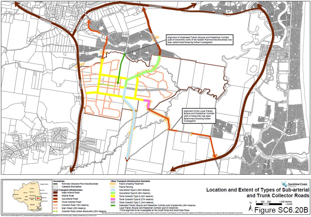
13 General advice for road transport infrastructure network outcomes (2) The following is general advice about satisfying the road transport infrastructure network outcomes:- the road transport infrastructure network outcomes seek to ensure that the Master Planned Area is developed with a highly interconnected and permeable road network that:- (i) (ii) (iii) supports high levels of bicycle and pedestrian use and prioritises these modes; supports high levels of access to public transport; and effectively services the area; (b) (c) (d) (e) (f) Other Plans Map OPM P8 (Palmview Master Planned Area road transport infrastructure network) in Schedule 2 (Mapping) identifies conceptually the higher order elements of the road transport infrastructure network planned for the Master Planned Area; Figure SC6.20B (Specification of transport infrastructure) identifies the location and extent of the types of sub-arterial road and district trunk collector road street servicing the Master Planned Area); Other Plans Map OPM P7 (Palmview Master Planned Area development and transport infrastructure network sequencing) in Schedule 2 (Mapping), Figure SC6.20B (Specification of transport infrastructure) and the applicable infrastructure agreement specifically identify the sequence of the higher order elements of the road transport infrastructure network planned for the Master Planned Area; road transport infrastructure is required to be provided throughout the Master Planned Area in accordance with Other Plans Map OPM P7 (Palmview Master Planned Area development and transport infrastructure network sequencing), Other Plans Map OPM P8 (Palmview Master Planned Area road transport infrastructure network) and the requirements of the applicable infrastructure agreement; the road transport infrastructure network is a key structural element that provides a framework for the following:- (i) (ii) (iii) the pattern of land use; the arrangement of neighbourhoods; and the configuration and alignment of local streets and other infrastructure networks; (g) the road transport infrastructure network outcomes are primarily intended to be satisfied by the following:- (i) development providing providing the major road transport infrastructure in accordance with the applicable infrastructure agreement; (ii) development ensuring that the road transport infrastructure to be provided is in accordance with the road transport infrastructure network and the standards for the road transport infrastructure network as specified in the Palmview structure plan area code; and (iii) the detailed design and construction of the road transport infrastructure network incorporating appropriate urban design, landscape and environmental features and treatments;. (iv) implementing a Sustainable Transport Plan which:- (A) outlines how the public and active transport outcomes for the Master Planned Area are to be achieved; (B) is to be assessed against the requirements specified in a preliminary approval to which section 242 of the Act applies or another applicable development approval which may include the matters in Table SC6.20H (Compliance assessment requirements); and (C) has been approved by a compliance certificate given by the Council. Standards for road transport infrastructure network outcomes (3) For the purposes of Performance Outcome PO11(b) in Section (Performance outcomes and acceptable outcomes for the development of infrastructure and services) of the Palmview structure plan area code, the following are the standards identified in the code for the road transport infrastructure network:- development accords with the development and transport infrastructure network sequencing specified on Other Plans Map OPM P7 (Palmview Master Planned Area development and Formatted: Font: Not Italic Formatted: Font: Bold Page SC14
14 transport infrastructure network sequencing) in particular the specified triggers for vehicle trips and Equivalent Dwellings, which is to be worked out as follows; Equivalent dwelling or ED means the measure of the demand for the number of vehicle trips equivalent to that generated by a Dwelling calculated for the relevant development type in Table SC6.20D (Applicable uses under the Structure Plan) using the demand generation rates specified in Table SC6.20E (Demand generation rate for development types). (b) development provides for major roads which comply with the design characteristics specified in Table SC6.20D 20F (Road transport infrastructure network - summary of design characteristics); (b)(c) development provides for roads which comply with the typical cross sections for each road type specified in Figures SC6.20C to SC6.20N20J; Formatted: Indent: Left: 2 cm, No Formatted: Font: Bold Formatted: Font: Not Bold Formatted: Font: Bold Formatted: Font: Bold Formatted: Font: Bold Formatted: Font: Bold Formatted: Font: Bold (c)(d) development provides for roads which comply with the following:- (i) cross sections and reserve widths vary to suit intersections, public transport priority treatments, turning lanes, bus stops, pedestrian crossing treatments, sewer pit requirements, lighting and other requirements; (ii) bus priority is provided at major intersections; (iii)(ii) verge areas are paved and landscaped in accordance with the typical cross sections in Figures SC6.20C to SC6.20N20J; (iv)(iii) where medians are provided, street lighting is accommodated within the median; (v)(iv) where provided, on road cycle lanes are incorporated into the road shoulder carriageway and continued through intersections with right turn cycle lanes provided along with advance storage boxes at controlled intersections; (vi)(v) where parking lanes are incorporated, the kerb is built out into the parking lanes to create landscaped kerb build-outs at regular intervals without impinging on cycle lanes; (vii) driveways are constructed as part of the development road works for lots with a kerb build-out on their frontage; (viii)(vi) priority channelised intersections (signalised where required) are provided where possible with the use of roundabouts minimised on higher order roads; (ix)(vii) legible directional and informational signage is to be supplied as necessary; (x)(viii) landscaping and stormwater treatment on verge areas and medians does not inhibit direct pedestrian access to on street parking or pedestrian movement across streets; (xi)(ix) landscaping includes appropriate root barrier protection to kerbs and adjacent services; (xii)(x) medians contain pedestrian refuge areas; (xiii)(xi) pedestrian refuge areas allow for functioning of stormwater treatments (i.e. median swales) where applicable, are not to impact on the location or functioning of pedestrian refuge areas; and (xiv)(xii) additional landscaping is provided consistent with the sub-tropical landscape character desired for the Master Planned Area; (d)(e) development provides for an infrastructure element within a major road corridor to comply with Table SC6.20E 20G (Minimum widths of infrastructure elements within road corridors); and (e)(f) development provides for a road to be designed and constructed in accordance with the Planning scheme policy for the transport and parking code and the Planning scheme policy for development works. Table SC6.20D Applicable uses under the Structure Plan Column 1 Development category Column 2 Development type Column 3 Uses under Structure Plan Formatted Table Residential development Attached dwelling Dual occupancy Formatted: Font: 9 pt Page SC15
15 Column 1 Development category Column 2 Development type Detached dwelling Retirement dwelling Other uses Column 3 Uses under Structure Plan Dwelling unit Multiple dwelling Residential care Short term accommodation Rooming accommodation Caretakers accommodation Community residence Dwelling house Retirement facility Other uses not listed will be determined at the time of the Application Non-residential development Commercial Office Health care service Car Wash Sales Office Veterinary services Community purpose Industry Retail and entertainment Other uses Community use Place of worship Educational establishment Child care centre Emergency services Community care centre Outdoor sport and recreation Low impact industry Service industry Bulk landscape supplies Research and technology industry Warehouse Utility installation Food and drink outlet Nightclub entertainment facility Shop Shopping centre Showroom Hotel Theatre Club Indoor sport and recreation Garden centre Function facility Adult store Service station Hardware and trade supplies Market Other uses not listed will be determined at the time of the Application Formatted Table Formatted: Font: 9 pt Page SC16
16 Table SC6.20E Demand generation rate for development types Formatted: Font: Bold Column 1 Development category Residential development Non-residential development Column 2 Development type Column 3 Unit of measure Column 4 Trips per unit of measure Column 5 Equivalent Dwelling per unit of measure Detached dwellings Per dwelling 9 1 Attached dwellings Per dwelling Retirement dwellings Per dwelling Commercial 100m 2 GFA Community purpose other than an Educational Establishment Community purpose for an Educational Establishment 100m 2 GFA Per student and staff Industry 100m 2 GFA Retail and entertainment 100m 2 GFA Table SC6.20D20F Road transport infrastructure network summary of design characteristics Formatted Table Formatted: Font: 9 pt Formatted: Font: 9 pt Formatted: Normal Road type Sub-arterial Road Type A Minimum road reserve width metres Typical features and treatments Two general movement lanes (one in each direction). On-road dedicated cycle lane each side. Landscaped median (where required by the applicable infrastructure agreement). Indented bus bays. Dual use path (3.0m minimum width) in each verge. Direct property access to major development only. Intersection spacing to be 300m minimum. No on-road car parking generally, but if provided to be in indented parking bays with corresponding increase in minimum road reserve width. Fauna fencing, crossings, and other structural/non-structural treatments as required. Dual carriageway with wide landscaped median and verges. No direct residential access. On-road dedicated bicycle lanes both sides. On-road dedicated transit lanes as specified on Other Plans Map OPM P9 (Palmview Master Planned Area Public Transport Infrastructure Network). 2 general movement lanes (1 in each direction). Indented bus bays. No on-road car parking. Dual use paths both sides (minimum width 3.5m. Informal boulevard design reinforcing Cross-section reference Figure SC6.20C, SC20.D and SC6.20E (Subarterial road type a A typical cross section) Page SC17
17 Road type Sub-arterial Road Type B (Note: this road is proposed to be constructed in two stages, as shown on the referenced crosssections) Trunk District Collector Street Collector Road Type A Minimum road reserve width metres metres Typical features and treatments bushland character at edges of the Master Planned Area transitioning to more formal boulevard design within Urban Development Area core. Fauna fencing, crossings and other structural/non-structural treatments as required. Four general movement lanes (two in each direction). On-road dedicated cycle lane each side. Landscaped median. Indented bus bays. Dual use path (3.0m minimum width):- o in each verge for the section of road within the Palmview Structure Plan Area boundary; and o in one verge only for the section of road outside the Palmview Structure Plan Area boundary. o Direct property access to major development only. o Intersection spacing to be 300m minimum. No on-road car parking generally, but if provided to be in indented parking bays with corresponding increase in minimum road reserve width. Fauna fencing, crossings, and other structural/non-structural treatments as required. Dual carriageway with wide landscaped median and verges. No direct residential access. On-road dedicated bicycle lanes both sides. 2 general movement lanes (1 in each direction). Indented bus bays. No on-road car parking. Dual use paths both sides (minimum width 3.5m. Informal boulevard design reinforcing bushland character at edges of the Master Planned Area transitioning to more formal boulevard design within Master Planned Area core. Fauna fencing, crossings and other structural/non-structural treatments as required. Two general movement lanes (one in each direction). On-street dedicated cycle lane each side. Landscaped median. Indented bus bays. Dual use path (3.0m minimum width) in one verge and footpath (2.0m minimum width) in other verge. Direct property access to major development only, or alternatively restricted to left in/left out. Intersection spacing to be 100m minimum. Indented parking bays. Fauna fencing, crossings, and other structural/non-structural treatments as Cross-section reference Figure SC6.20E 20F, SC6.20G and SC6.H (Subarterial road type b B typical cross section) Figure SC6.20G 20I and SC6.20J (Trunk District Ccollector road Street type a typical cross section) Formatted: Indent: Left: 0.3 cm, No Formatted Formatted: Indent: Left: 0.9 cm, No Page SC18
18 Road type Trunk Collector Road Type B Trunk Collector Road Type C Minimum Typical features and treatments road reserve width required. Dual carriageway with wide landscaped median and verges. Parking lanes or indented parking both sides. Indented bus bays. On-road dedicated bicycle lanes both sides. 1 general traffic lane in each direction. Dual use paths both sides. Formal boulevard design. Fauna fencing, crossings and other structural/non-structural treatments as required. 27 metres Dual carriageway with wide landscaped median and verges. No on-road car parking. Indented bus bays. On-road dedicated bicycle lanes both sides. 1 general traffic lane in each direction. Dual use paths both sides. Formal boulevard design. Fauna fencing, crossings and other structural/non-structural treatments as required. 34 metres Dual carriageway with wide landscaped median and verges. Indented bus bays. On-road dedicated bicycle lanes both sides. On-road dedicated transit lanes as specified on Other plans Map OPM P9 (Palmview Master Planned Area Public Transport Infrastructure Network). 1 general traffic lane in each direction. Dual use paths both sides. Formal boulevard design. Fauna fencing, crossings and other structural/non-structural treatments as required. Main Street 25 metres Pedestrian, cycle and vehicle shared zone designed in accordance with the outcomes identified in Table SC6.20C (Design outcomes for shared zones). Pavement treatments which clearly define the extent of the shared zone. Single level pavement (no kerb). Minimal signage and line markings. Lighting for the safety of pedestrians, cyclists and motor vehicles. Informal landscaping. Indented parking both sides. Indented bus bays if required. Cross-section reference Figure SC6.20H (Trunk collector road type b typical cross section) Figure SC6.20I (Trunk collector road type c interim cross section) Figure SC6.20J (Main street typical cross section) Formatted: Indent: Left: 0.9 cm, No Collector Road (Green Boulevard) Note further detail in relation to design requirements for the District Activity Centre and the Main Street is provided in Section SC (Particular precinct outcomes). 25 metres Single carriageway with wide landscaped verges. Parking lanes or indented parking both sides. On-road dedicated bicycle lanes. Dual use paths both sides. Indented bus bays. Figure SC6.20K (Collector road (green boulevard) typical cross section) Page SC19
19 Road type Collector Road Minimum Typical features and treatments road reserve width Informal boulevard design reinforcing bushland character at edges of the Master Planned Area transitioning to more formal boulevard design within Master Planned Area core. Fauna fencing, crossings and other structural/non-structural treatments as required. 18 metres Single carriageway with landscaped verges. Parking un-marked. Bicycles accommodated in carriageway (no dedicated lanes). 2 general movement lanes. Footpaths both sides. Indented bus bays where required. Informal boulevard design reinforcing bushland character at edges of the Master Planned Area transitioning to more formal boulevard design within Master Planned Area core. Fauna fencing, crossings and other structural/non-structural treatments as required. Access Street 14 metres Single carriageway with landscaped verges. Parking un-marked. 2 general movement lanes. Footpath one side. Bicycles accommodated on-road (shared). Access Place 14 metres Single carriageway with landscaped verges. Parking un-marked. 2 general movement lanes. No footpaths. Bicycles accommodated in carriageway (no dedicated lanes). Cross-section reference Figure SC6.20L (Collector road typical cross section) Figure SC6.20M (Access street typical cross section) Figure SC6.20N (Access place / laneway typical cross section) Table SC6.20E20G Minimum widths of infrastructure elements within road corridors Infrastructure element Roads (general traffic lanes) Parking lanes Parking lanes (where shared with cycle lanes) Parking lanes (where shared with bus bays) Dual use paths Footpaths Recreation paths Commuter paths Cycle lanes Bus lane Median Minimum width 3.5 metres on sub-arterial roads 3.3 metres on district collector streets metres 4.5 metres 2.5 metres metres* 2 metres* metres 3.0 metres metres (where < 60km/hr)* on district collector streets 1.8 metres (where >= 60km/hr)* 2 metres on sub-arterial roads or where > 80km/hr on other roads)* 3.7 metres 4-6 metres (on sub-arterial and trunk collector roads 3 metres on district collector streetsto accommodate turning lanes). Page SC20
20 Infrastructure element Verge Minimum width metres on sub-arterial roads 5.5 metres on district collector streets * Wider provision may be required for these elements for the Collector Road (Green Boulevard), the Main Street, the Dedicated Transit, Bicycle and Pedestrian Corridor (part of Greenlink) and the Local Transit, Bicycle and Pedestrian Corridor (part of Greenlink). Refer to relevant cross sections. Page SC21
21 Figure SC6.20B Specification of transport infrastructure Page SC22
22 Page SC23

23 Figure SC6.20C Sub-arterial road Road Typetype a A with centre Figure SC6.20D Sub-arterial road Road type Type a A southern link Page SC24

24 median typical cross section bridge cross sectionwith no centre median Page SC25

25 Sub-Arterial Type AClaymore Road Link Southern Link BridgeClaymore Road Link Page SC26

26 Figure SC6.20E Sub-arterial road Road type Type b A typical cross sectionbridge Figure SC6.20F Sub-arterial road Road type Type b B claymore road bridge cross sectionwith kerb and channel Formatted: Centered Page SC27
27 Sub-Arterial Type BClaymore Road Bridge Claymore Road BridgeSouthern Road Link Page SC28

28 Figure SC6.20G Trunk collector road type a typical cross sectionsubarterial Road Type B with table drains Figure SC6.20H Trunk collector road type b typical cross sectionsubarterial Road Type B bridge Page SC29

29 Trunk Collector Type ASouthern Road Link Trunk Collector Type BSouthern Road Link Bridge Page SC30


30 Figure SC6.20I Trunk collector road type c interim cross sectiondistrict Collector Street Figure SC6.20J Main street typical cross sectiondistrict Collector Street Bridge Formatted Table Page SC31
31 Trunk Collector Type CDistrict Collector Street Main StreetSpringhill Drive Bridge Page SC32
32 Formatted: List Paragraph Page SC33

33 Figure SC6.20K Collector road (green boulevard) typical cross Section Figure SC6.20L Collector road typical cross section Collector Road Green Boulevard Collector Road Page SC34

34 Figure SC6.20M Access street typical cross section Figure SC6.20N Access place typical cross section Access Street Access Place Page SC35
35 Standards, guidelines and advice for fauna movement outcomes (4) For the purposes of Performance Outcome PO11(b) in Section (Performance outcomes and acceptable outcomes for the development of infrastructure and services) of the Palmview structure plan area code, the following are the standards identified in the code for the fauna movement outcomes incorporated as part of the road transport infrastructure network:- (b) development provides the fauna fencing in association with the road and public transport corridors in accordance with the specifications in Figure SC6.20O 20K (Typical fauna fence design); and development provides for the other fauna movement measures specified in Table SC6.20F 20H (Other fauna movement measures). (5) For the purposes of Performance Outcome PO11(b) in Section (Performance outcomes and acceptable outcomes for the development of infrastructure and services) of the Palmview structure plan area code, the following are guidelines about satisfying the standards in the code for the fauna movement outcomes:- (b) (c) (d) Fauna Sensitive Road Design Volume 1 - Past and Existing Practices (Queensland Department of Main Roads, 2000); Fauna Sensitive Road Design Manual Volume 2 Preferred Practices (Queensland Department of Transport and Main Roads, 2010); Fish Passage in Streams Guidelines for Design of Stream Crossings (Queensland Department of Primary Industries and Fisheries, 1998); and Breaking the Barriers Engineering Solutions to Ecological Problems (Symposium) (Environment Institute of Australia and New Zealand, 2009). (6) For the purposes of Performance Outcome PO11(b) in Section (Performance outcomes and acceptable outcomes for the development of infrastructure and services) of the Palmview structure plan area code, the following is advice about satisfying the standards in the code for the fauna movement outcomes:- (b) the design of fauna protection measures should reflect landscape context, site conditions and the species being targeted; and an applicant should consult with the Council to determine the most appropriate measures to be implemented. Page SC36
36 Figure SC6.20O20K Typical fauna fence design Page SC37
37 Table SC6.20F20H Other fauna movement measures Measure OVERPASS Land Bridge Overpass (small roads) Canopy/Rope Bridge Glider Pole Local Traffic Management UNDERPASS Culvert Tunnel Bridge NON-STRUCTURAL MITIGATION Corridor Plantings Descriptions PERMITS PASSAGE OF ANIMALS ABOVE THE ROAD Also known as a green bridge, eco-duct or wildlife bridge. Typically a 30 metre wide bridge that spans across the road. The bridge has soil over it, and is planted with vegetation and landscaped with habitat features (e.g. logs, rocks, small water bodies etc.). A bridge above a major road, likely to allow human/stock access across the road. Typically of a narrow design and not hour-glass shape. An overpass is commonly a minor road, possibly unsealed or single lane configuration. A rope or pole suspended above traffic, either from vertical poles or roadside trees. Primarily established for arboreal and scansorial species. Vertical poles positioned in the centre median, on the road verge, or traversing the land bridge. They provide species that glide intermediary landing pads and launch opportunities. Traffic calming to reduce the speed or volume of traffic via signage, crosswalks, chicanes, road closures etc. PERMITS PASSAGE OF ANIMALS BELOW THE ROAD Frequently square, rectangular or semi-circle in shape. Usually pre-cast concrete cells or arches made of steel. They may specifically be built for wildlife passage or stormwater or flood conveyance purposes or a combination of both. Also known as eco-pipe. Commonly round pipes of reasonably small diameter (i.e. less than 1.5 metres) A structure that raises traffic above surrounding land or maintains the grade of the road. Often facilitating water underneath, movement of local traffic or assisting wildlife passage. INCORPORATES MORE SENSITIVE ROAD DESIGN THAT ASSISTS NATURAL PERMEABILITY Strips of vegetation, comprising of similar species either side of the road. Often crossing the road providing corridor movements for animals. SC Public transport infrastructure network outcomes Preliminary (1) This section applies to the public transport infrastructure network outcomes in Performance Outcomes PO14 to PO19 PO18 in Section (Performance outcomes and acceptable outcomes for the development of infrastructure and services) of the Palmview structure plan area code. General advice for public transport infrastructure network outcomes (2) The following is general advice about satisfying the public transport infrastructure network outcomes:- (b) the public transport infrastructure network outcomes seek to ensure that the Palmview Master Planned Area is able to be provided with a high quality public transport service connecting major employment, retail, business, education, recreation, sporting, cultural and health facilities; Other Plans Map OPM P9 (Palmview Master Planned Area public transport infrastructure network) in Schedule 2 (Mapping) conceptually identifies the principal elements of the public transport infrastructure network, including the following:- (i) the dedicated transit, bicycle and pedestrianlocal public transport corridor (part of the Greenlink); (ii) the local transit, bicycle and pedestrian corridor (part of the Greenlink); (iii) dedicated on-road transit lanes; (iv)(ii) local bus loopservicess; and (v)(iii) bus stops and transit stations; Page SC38
38 (c) (d) (e) (f) (g) increasing the proportion of public transport trips both within the Master Planned Area and to locations outside of the Master Planned Area will not only serve to improve the sustainability of the Palmview community but will also contribute to a healthier community; public transport services are intended to be bus-based and form part of Translink s Sunshine Coast Network Plan. The higher order road network has been carefully designed to support the efficient circulation of buses and to provide for priority movement along identified key routes; there is also a high level of functional integration between the public transport and bicycle and pedestrian infrastructure networks (including end of trip facilities) and it is intended that these networks be developed in unison to support the development of the Master Planned Area as a transit oriented community; the requirements for public transport infrastructure are to be complemented with a broader strategy for the provision and use of public transport services and are to deliver a seed program for public transport during the first phases of development has provided for in the applicable infrastructure agreement; and the public transport infrastructure network outcomes are primarily intended to be satisfied by the following:- (i) (ii) (iii) (iv) development providing public transport infrastructure in accordance with the applicable infrastructure agreement; development ensuring that the public transport infrastructure to be provided, and in particular the local transit, bicycle and pedestrianpublic transport corridor (part of the Greenlink), is in accordance with the public transport infrastructure network and the standards for the public transport infrastructure network as specified in the Palmview structure plan area code; and the detailed design and construction of the public transport infrastructure network incorporating appropriate urban design, landscape and environmental features and treatments; and. implementing a Sustainable Transport Plan which:- (A) outlines how the public and active transport outcomes for the Master Planned Area are to be achieved; (B) is to be assessed against the requirements specified in a preliminary approval to which section 242 of the Act applies or another applicable development approval which may include the matters in Table SC6.20H (Compliance Assessment Requirements); and (C) has been approved by a compliance certificate given by the Council. Standards for public transport infrastructure outcomes Formatted: Highlight (3) For the purposes of Performance Outcome PO14(b) in Section (Performance outcomes and acceptable outcomes for the development of infrastructure and services) of the Palmview structure plan area code, the following are the standards identified in the code for the dedicated transit, bicycle and pedestrian corridor (part of Greenlink) and the local transit, bicycle and pedestrian corridor (part of Greenlink) (Greenlink Corridor) incorporated as part of the public transport infrastructure network:- (b) (c) development provides for the Greenlink Corridor to be incorporated into the Trunk Collector Road where they share a common alignment; development provides for the Greenlink Corridor within the Master Planned Area to incorporate the following elements:- (i) a two lane dedicated busway (one lane each way); (ii) a 5.5 metre wide dual use path; (iii) a two (2) metre wide on road cycle lane; (iv) supporting stormwater infrastructure; and (v) underground services and street lighting; development provides for the bus lane component of that part of the Greenlink which is within and approaches the District Activity Centre to be:- (i) transitioned to a shared zone in accordance with Other Plans Map OPM P9 (Palmview Master Planned Area Public Transport Infrastructure Network) in order to maximise urban design outcomes in the District Activity Centre; and Page SC39
39 (ii) designed such that buses, pedestrians and cyclists receive priority at the point of transition to shared lanes and at intersections; (d) (e) (f) (g) (h) development provides for the Greenlink Corridor within the Master Planned Area to comply with the typical cross sections specified in Figure SC6.20P (Greenlink corridor (dedicated alignment) - typical cross section) and Figure SC6.20Q (Greenlink corridor (dedicated alignment) greenlink bridge cross section); development provides for safe crossing treatments and intersections; development provides noise attenuation to sensitive receiving environments; development provides for that part of the Greenlink Corridor traversing Sippy Creek to be on elevated structure or otherwise constructed so as to minimise impacts on hydrological regimes and ecological values, and to comply with the typical cross section specified in Figure SC6.20Q (Greenlink corridor (dedicated alignment) greenlink bridge cross section); and development ensures that the public transport infrastructure is planned, designed and constructed in accordance with the Planning scheme policy for development works and the Public Transport Infrastructure Manual (Translink and DTMR). Page SC40
 - greenlink bridge cross section Green Link Green Link")
40 Figure SC6.20P Greenlink corridor (dedicated alignment) - typical cross section Figure SC6.20Q Greenlink corridor (dedicated alignment) - greenlink bridge cross section Green Link Green Link Bridge Page SC41
Part 10 Other plans
 Contents of Part 10 Part 10 Other plans... 10-1 10.1 Preliminary... 10-1 10.2 Palmview Structure Plan... 10-2 10.2.1 Preliminary... 10-2 10.2.2 Master Strategic Framework... 10-6 10.2.3 Master Precincts
Contents of Part 6. Part 6 Zones
 Contents of Part 6 Part 6 Zones... 6-1 6.1 Preliminary... 6-1 6.2 Zone codes... 6-3 6.2.1 Low density residential zone code... 6-3 6.2.1.1 Application... 6-3 6.2.1.2 Purpose and overall outcomes... 6-3
Amendments to the Palmview Structure Plan (amended text)
") Appendix A Amendments to the Palmview Structure Plan (amended text) Part 10 Other Plans 10.3 Palmview Structure Plan 10.3.1 Preliminary 10.3.1.1 Introduction This Part comprises the Palmview Structure
Appendix A Amendments to the Palmview Structure Plan (amended text) Part 10 Other Plans 10.3 Palmview Structure Plan 10.3.1 Preliminary 10.3.1.1 Introduction This Part comprises the Palmview Structure
I615. Westgate Precinct
 I615. Westgate Precinct I615.1. Precinct Description The Westgate Precinct is located approximately 18km west of the Auckland city centre. There are seven Sub-precincts in the Westgate Precinct: Sub-precinct
6.6.2 Emerging Community Zone Code Application Purpose and overall outcomes. s6 Zone Codes Emerging Community and Township Zone Codes
 6.6.2 Emerging Community Zone Code 6.6.2.1 Application This code applies to assessable development:- (1) within the Emerging Community Zone as identified on the zoning maps contained within Schedule 2
FORMER CANADIAN FORCES BASE (CFB) ROCKCLIFFE SECONDARY PLAN. Official Plan Amendment XX to the Official Plan for the City of Ottawa
 ROCKCLIFFE SECONDARY PLAN. Official Plan Amendment XX to the Official Plan for the City of Ottawa") FORMER CANADIAN FORCES BASE (CFB) ROCKCLIFFE SECONDARY PLAN Official Plan Amendment XX to the Official Plan for the City of Ottawa 1 INDEX THE STATEMENT OF COMPONENTS PART A THE PREAMBLE PAGE Purpose...
FORMER CANADIAN FORCES BASE (CFB) ROCKCLIFFE SECONDARY PLAN Official Plan Amendment XX to the Official Plan for the City of Ottawa 1 INDEX THE STATEMENT OF COMPONENTS PART A THE PREAMBLE PAGE Purpose...
Complete Neighbourhood Guidelines Review Tool
 Complete Neighbourhood Guidelines Review Tool Prepared By: City of Regina Planning Department October 2014 Page 1 of 14 Community Development Review Checklist for Secondary Plans and Concept Plans The
Northern Territory Compact Urban Growth Policy
 Northern Territory Compact Urban Growth Policy A Reference Policy Document to clause 2.7 (Reference to Policy) of the NT Planning Scheme May 2015 Table of Contents 1 Policy Setting... 3 1.1 Context for
Keystone Business Park Precinct Structure Plan North East Industrial Precinct. Part 2 Design Principles
 Keystone Business Park Precinct Structure Plan North East Industrial Precinct Part 2 Design Principles Context Issues Services Landform Issues Geotech and contamination Ecology Traffic and access Issues
MASTER PLAN NO. 60 (SITE DEVELOPMENT PLAN EASTBANK/REGATTA NORTH PRECINCTS 2 4) 2008
 2008") Page 2 TABLE OF CONTENTS PAGE 1 PRELIMINARY... 5 1.1 CITATION... 5 1.2 TYPE OF MASTER PLAN... 5 1.3 LEGAL REQUIREMENT FOR MASTER PLAN... 5 1.4 LEGAL EFFECT OF THE MASTER PLAN... 5 2 DESCRIPTION OF LAND...
Page 2 TABLE OF CONTENTS PAGE 1 PRELIMINARY... 5 1.1 CITATION... 5 1.2 TYPE OF MASTER PLAN... 5 1.3 LEGAL REQUIREMENT FOR MASTER PLAN... 5 1.4 LEGAL EFFECT OF THE MASTER PLAN... 5 2 DESCRIPTION OF LAND...
Chapter 13 Residential Areas: Appendices APPENDIX 1 Residential Areas
 Chapter 13 Residential Areas: Appendices Page 1 Chapter 13 Residential Areas: Appendices APPENDIX 1 Residential Areas Design Code for Intensive Housing INTRODUCTION DESIGN ELEMENTS A NEIGHBOURHOOD DESIGN
I539. Smales 2 Precinct
 I539. Smales 2 Precinct I539.1. Precinct Description The Smales 2 Precinct applies to a 4.8 hectare block of land located on the southern side of Northcote Road and fronting Lake Pupuke, Takapuna. The
Section Three, Appendix 17C Multiple Unit Housing Design Assessment Criteria
 APPENDIX 17C MULTIPLE UNIT HOUSING DESIGN ASSESSMENT CRITERIA Purpose of Appendix 17C In the Residential 9 Zone the construction and use of multiple household units located within the Multiple Household
3.1 community vision. 3.3 required plan elements
 Chapter 3 Community Form 3.1 community vision 3.2 Parks & landscaping concepts 3.3 required plan elements D R A F T 20 Community Form Chapter 3 3.0 Community form 3.1 community vision The Specific Plan
Appendix D: Rockbank Major Town Centre key design principles
 Appendix D: Rockbank Major Town Centre key design principles ATTRACTING INVESTMENT & SUPPORTING THE COMMUNITY Principle 1 Create a focal point for a diverse range of uses within the town centre that are
Section Three, Appendix 16C Medium Density Housing, Design Assessment Criteria (Residential 8A zone)
") APPENDIX 16C MEDIUM DENSITY HOUSING, DESIGN ASSESSMENT CRITERIA (RESIDENTIAL 8A ZONE) PURPOSE OF APPENDIX 16C (RESIDENTIAL 8A ZONE) In the Residential 8A Zone the following are defined as restricted discretionary
APPENDIX 16C MEDIUM DENSITY HOUSING, DESIGN ASSESSMENT CRITERIA (RESIDENTIAL 8A ZONE) PURPOSE OF APPENDIX 16C (RESIDENTIAL 8A ZONE) In the Residential 8A Zone the following are defined as restricted discretionary
GREENVALE CENTRAL PRECINCT STRUCTURE PLAN
 76 Conservation area boundary. Low Fence to exclude vehicles but allow pedestrian access Front boundary of allotment 5.0m MINIMUM SETBACK Path providing public access to dwellings fronting Conservation
SCHEDULE 12 TO THE DESIGN AND DEVELOPMENT OVERLAY GLEN WAVERLEY ACTIVITY CENTRE STRUCTURE PLAN
 DD/MM/YY Proposed C120 SCHEDULE 12 TO THE DESIGN AND DEVELOPMENT OVERLAY Shown on the planning scheme map as DDO12. GLEN WAVERLEY ACTIVITY CENTRE STRUCTURE PLAN 1.0 Design objectives DD/MM/YY Proposed
Part 10 Other plans
 Contents of Part 10 Part 10 Other plans... 10-1 10.1 Preliminary... 10-1 10.2 Maroochydore Principal Regional Activity Centre (PRAC) Structure Plan... 10-2 10.2.1 Preliminary... 10-2 10.2.2 Master Strategic
URBAN DESIGN BRIEF URBAN DESIGN BRIEF 721 FRANKLIN BLVD, CAMBRIDGE August 2018
 URBAN DESIGN BRIEF URBAN DESIGN BRIEF 721 FRANKLIN BLVD, CAMBRIDGE August 2018 DESIGN BRIEF CONTENTS PART A 1.0 INTRODUCTION 2.0 DESCRIPTION & ANALYSIS OF SITE CONTEXT 3.0 DESIGN CONSTRAINTS AND OPPORTUNITIES
Urban Design Guidelines
 Urban Design Guidelines These Urban Design Guidelines comprise the Key Design Objectives below, the Roads Design Guidelines overleaf and Neighbourhood Framework Plans. Together with Section 3: Urban Design
LOW DENSITY RESIDENTIAL
 LOW DENSITY RESIDENTIAL Corner lots with coach houses to increase diversity, provide unity to the streetscape and increase eyes on the street. Garages and ancillary units accessed via rear lanes. Parking
97 Lea Bridge Road, Leyton, E10 7QL London Borough of Waltham Forest December 2015
 97 Lea Bridge Road, Leyton, E10 7QL London Borough of Waltham Forest December 2015 Public Realm and Landscape Proposals LEA BRIDGE ROAD, WALTHAMSTOW Public Realm & Landscape Proposals BDP(90)RPT001 December
Westwind Developments Ltd. PIONEER LANDS AREA STRUCTURE PLAN - PROPOSED AMENDMENT
 FEBRUARY 2013 TABLE OF CONTENTS 1.0 BACKGROUND... 1 1.1 Amendment... 1 2.0 LOCATION & CONTEXT... 2 2.1 Land Ownership... 2 3.0 POLICY CONTEXT... 3 3.1 Municipal Development Plan... 3 3.2 Capital Region
(DC1) Direct Development Control Provision DC1 Area 4
 Direct Development Control Provision DC1 Area 4") . General Purpose (DC) Direct Development Control Provision DC Area 4 The purpose of this Provision is to provide for an area of commercial office employment and residential development in support of the
. General Purpose (DC) Direct Development Control Provision DC Area 4 The purpose of this Provision is to provide for an area of commercial office employment and residential development in support of the
4 Residential and Urban Living Zones
 4 Residential and Urban Living Zones Refer to Chapters 11 to 20 for additional rules that may apply to these zones. 4.1 OBJECTIVES AND POLICIES Objective Res1 Policy 1 Policy 2 Policy 3 Policy 4 Policy
Chapter 5 Urban Design and Public Realm
 5.1 Introduction Public realm is all areas of the urban fabric to which the public have access. It is where physical interaction takes place between people. It therefore, includes buildings and their design,
Next Steps / Development Process. Structure Plan. June submitted to City of Fremantle. Structure Plan. July supported for advertising
 overview What is today about? In July 0, the City of Fremantle resolved that the be advertised for public comment. Today is about: Understanding the history and context of the site Having your say on the
appendix and street interface guidelines
 appendix five: building and street interface guidelines appendix 5 building and street interface guidelines BOULEVARDS Boulevards are generally characterized by higher levels of traffic movement at higher
and services The protection and conservation of environmentally significant and sensitive natural heritage features and functions.
 6. Land Use 6.0 Preamble A healthy and livable city is one in which people can enjoy a vibrant economy and a sustainable healthy environment in safe, caring and diverse neighbourhoods. In order to ensure
The Proposed Auckland Unitary Plan (notified 30 September 2013)
") 3 Business zones Introduction There are 10 business zones in the Unitary Plan: City Centre Metropolitan Centre Town Centre Local Centre Neighbourhood Centre Mixed Use General Business Business Park Light
3 Business zones Introduction There are 10 business zones in the Unitary Plan: City Centre Metropolitan Centre Town Centre Local Centre Neighbourhood Centre Mixed Use General Business Business Park Light
GREENBANK DEVELOPMENT MASTERPLAN
 DEVELOPMENT MASTERPLAN POTENTIAL TRAIN STATION COMMUNITY CENTRE Greenbank will be a connected masterplanned community providing easy access to local and surrounding amenity. Affordable quality homes, green
East Bayshore Road Neighbourhood
 East Bayshore Road Neighbourhood Northridge Property Management Urban Design Brief 3195 East Bayshore Road City of Owen Sound January 2016 East Bayshore Road Neighbourhood Northridge Property Management
Section 5 (S5) - Sneydes Parade
 - Sneydes Parade") EAST WERRIBEE EMPLOYMENT PRECINCT PRECINCT STRUCTURE PLAN 15m High Large Canopy Tree encouraged 41.4 6.0 4.2 2.0 0.3 300mm Kerb 3 Lane incl. dedicated bus lane 6m median (Trees at 25m spacing) 3 Lane incl.
EAST WERRIBEE EMPLOYMENT PRECINCT PRECINCT STRUCTURE PLAN 15m High Large Canopy Tree encouraged 41.4 6.0 4.2 2.0 0.3 300mm Kerb 3 Lane incl. dedicated bus lane 6m median (Trees at 25m spacing) 3 Lane incl.
CONTENTS 8.0 LAND USE 8.1 GENERAL LAND USE 8.2 RESIDENTIAL 8.3 MIXED USE 8.4 COMMERCIAL 8.5 EMPLOYMENT LANDS
 8-2 Land Use 8.0 LAND USE CONTENTS 8.1 GENERAL LAND USE 8.1.1 Uses provided for in all Land Use Designations 8.1.2 Uses prohibited in Hazardous Lands, Hazardous Sites and Special Policy Areas 8.1.3 Uses
8.0 Design and Form of Development 43/
 42/ 8.0 Design and Form of Development 43/ Rothwells Farm, Golborne/ Development Statement Figure 7. Site Constraints Key 44/ Site Boundary 360 Bus Route/Stops Existing Trees Underground Water Pipe Sensitive
Part 9 Specific Land Uses - Housing on Small and Narrow Lots
 19 HOUSING ON SMALL AND NARROW LOTS This section of the DCP applies where development for the purpose of a dwelling house, attached dwellings, or semi-detached dwellings is or are proposed in the R2 Low
39 WALLACEVILLE STRUCTURE PLAN
 39 WALLACEVILLE STRUCTURE PLAN PRECINCT DESCRIPTIONS, INTENTIONS AND OUTCOMES Wallaceville Living Precinct Area A At approximately 13.4ha, this precinct is the largest precinct and the precinct provides
Memorial Business Park Site. Proposed Future Development. Design guidelines. August
 Memorial Business Park Site Proposed Future Development Design guidelines August 2014 www.designenvironment.co.nz 0064 3 358 3040 Contents 1.0 Background 1.1 Introduction 3 1.2 Objectives 4 2.0 Context
DRAFT Northeast Quadrant of Kipling Avenue and Highway 7 DRAFT AUGUST 29, Goals Land Use. The goals of this Plan are to:
 AUGUST 29, 2017 12.15 Northeast Quadrant of Kipling Avenue and Highway 7 12.15.1 Goals 12.15.2 Land Use The goals of this Plan are to: 12.15.2.1 General Provisions: a) Ensure the development of a compact
URBAN DESIGN BRIEF. 2136&2148 Trafalgar Road. Town of Oakville
 URBAN DESIGN BRIEF 2136&2148 Trafalgar Road Town of Oakville Prepared By: METROPOLITAN CONSULTING INC For 2500674 Ontario Inc November 2016 TABLE OF CONTENTS Page No. 1.0 Introduction/Description of Subject
MASTER PLAN NO. 62 (SITE DEVELOPMENT PLAN BIRTINYA VILLAGE CENTRE) 2009
 2009") Development Agreement, Development Control Plan 1 - Kawana Waters and Section 6.1.45A (Development Control Plans under Repealed Act) of the Integrated Planning Act 1997 MASTER PLAN NO. 62 (SITE DEVELOPMENT
Development Agreement, Development Control Plan 1 - Kawana Waters and Section 6.1.45A (Development Control Plans under Repealed Act) of the Integrated Planning Act 1997 MASTER PLAN NO. 62 (SITE DEVELOPMENT
Subdivision Design Criteria. Penihana North GUIDELINES TO THE RULES
 Created September 2013 Penihana North Subdivision Design Criteria GUIDELINES TO THE RULES This part of the Plan sets out the design criteria for subdivision in Penihana North. The criteria will be considered
Mark-up of the effect of the proposed Bronte Village Growth Area OPA No.18 on the text of section 24, Bronte Village, of the Livable Oakville Plan
 Mark-up of the effect of the proposed Bronte Village Growth Area OPA No.18 on the text of section 24, Bronte Village, of the Livable Oakville Plan Notes: This document is provided for information purposes
Development Control Plan
 Development Control Plan Liberty Grove Development Control Plan Date of Adoption: 4 September 2007 Effective Date: 7 March 2008 Index 1 INTRODUCTION... 3 1.1 NAME OF PLAN... 3 1.2 AREA TO WHICH THIS PLAN
Appendix H: Easement cross sections
 Appendix H: Easement cross sections SHARED PATH 1.5m FOOTPATH NATURE STRIP 7.3m CARRIAGEWAY 2.7m NATURE STRIP EXISTING PIPELINE 150mm DIA 5.0m (approx.) LOCAL ACCESS ROAD EXISTING PIPELINE 500mm DIA 2.7m
4.0 URBAN DESIGN FRAMEWORK. The vision for the future development of the plan area is to:
 4.0 The vision for the future development of the plan area is to: Create a new neighbourhood that focuses on the highly valued natural and aesthetic features of the lands and provides good quality homes,
QUEENSTOWN LAKES DISTRICT COUNCIL SUBDIVISION DESIGN GUIDELINES
 Attachment C: Draft QLDC Subdivision Design Guidelines QUEENSTOWN LAKES DISTRICT COUNCIL DESIGN GUIDELINES A DESIGN GUIDE FOR AND DEVELOPMENT IN THE URBAN ZONES QUEENSTOWN OFFICE 10 Gorge Road Queenstown
BLETCHLEY PARK AREA - DEVELOPMENT FRAMEWORK
 ANNEX A To Item 9 REVISED TEXT: additions shown bold and underlined, deletions in (brackets and in italics). BLETCHLEY PARK AREA - DEVELOPMENT FRAMEWORK This framework sets out the key objectives and requirements
Division 13 Local Business and Industry Buffer Zone: Assessment Criteria and Assessment Tables
 Division 13 Local Business and Industry Buffer Zone: Assessment Criteria and Assessment Tables 4.13.1 Local Business and Industry Buffer Zone The provisions in this division relate to the Local Business
7.2.9 Eudlo local plan code
 7.2.9 local plan code 7.2.9.1 Application (1) This code applies to assessable development:- (a) within the local plan area as shown on Map ZM29 contained within Schedule 2 (Mapping); and (b) identified
11.3 SPECIAL CHARACTER ZONE HAWKE S BAY REGIONAL SPORTS PARK
 11.3 SPECIAL CHARACTER ZONE HAWKE S BAY REGIONAL SPORTS PARK 11.3.1 INTRODUCTION The availability of sports and recreation activities and facilities is important for the maintenance and enhancement of
CONTENTS 6.1 URBAN DESIGN
 6-2 Urban Design and Sustainable Development 6.0 URBAN DESIGN AND SUSTAINABLE DEVELOPMENT CONTENTS 6.1 URBAN DESIGN 6.1.1 General Policies 6.1.2 The Public Realm 6.1.3 Streets and Blocks 6.1.4 Streetscapes
Proposed Amendments to Sunshine Coast Planning Scheme 2014 Review of Submissions Key Issues Discussion Paper. Palmview
 Proposed Amendments to Sunshine Coast Planning Scheme 2014 Review of Submissions Key Issues Discussion Paper. Palmview Key Issue: No. of submissions: Amendments to Palmview Structure Plan 155 submissions
medium desnity housing
 This section updated September 2013 This part of the Plan sets out the assessment criteria for medium density housing. The criteria are designed to give designers and builders flexibility and to provide
UNIVERSITY TOWN NEIGHBOURHOODS 5.5 HOUSING MELBOURNE CAMPUS MASTER PLAN 2014
 5.5 169 EXISTING CONDITIONS & VISION NEIGHBOURHOOD VISION The provision of on-campus housing into the future will continue to be an important element of the La Trobe University experience. A long-term
Tāhuhu whakaruruhau ā-taone The sheltering ridge pole
 B2. Tāhuhu whakaruruhau ā-taone - Urban growth and form B2.1. Issues Tāhuhu whakaruruhau ā-taone The sheltering ridge pole Auckland s growing population increases demand for housing, employment, business,
Community Design Guidelines. Port Wallace DRAFT
 Community Design Guidelines Port Wallace DRAFT Energy 1 2 3 Nature Movement Connections Built Form DRAFT Layout Energy 1 Nature Community Design Guidelines GREAT COMMUNITIES PROTECT, CELEBRATE, AND CONSERVE
North Oakville East Parks Facilities Distribution Plan. November, 2009
 North Oakville East November, 2009 POLICY CONTEXT 1) Purpose a) The purpose of this document is to be a guide for the location, configuration, design and development of the parks system for the North Oakville
New-Cast Mixed-use Development Proposal King Street West, Newcastle, Ontario
 URBAN DESIGN BRIEF New-Cast Mixed-use Development Proposal King Street West, Newcastle, Ontario TABLE OF CONTENTS: 1.0 Executive Summary 2.0 Creating Vibrant and Sustainable Urban Places: Excerpts from
Cape Cabarita (Formerly known as the Wellcome Site) Development Control Plan. Date of Adoption: 4 September 2007 Effective Date: 7 March 2008
 Development Control Plan. Date of Adoption: 4 September 2007 Effective Date: 7 March 2008") Cape Cabarita (Formerly known as the Wellcome Site) Development Control Plan Date of Adoption: 4 September 2007 Effective Date: 7 March 2008 Development Control Plan Index 1 INTRODUCTION...3 1.1 LAND TO
Cape Cabarita (Formerly known as the Wellcome Site) Development Control Plan Date of Adoption: 4 September 2007 Effective Date: 7 March 2008 Development Control Plan Index 1 INTRODUCTION...3 1.1 LAND TO
FLORIN ROAD CORRIDOR Site Plan and Design Review Guidelines Checklist
 FLORIN ROAD CORRIDOR Site Plan and Design Review Guidelines Checklist Applicant s Name: Project Address: Phone: Email: Applicant shall fill out the design guidelines checklist for all guidelines applicable
The West Vaughan Employment Area Secondary Plan Policies
 Part 2: The West Vaughan Employment Area Secondary Plan Policies 2.1 General Policies It is the policy of Council: 2.1.1. That the West Vaughan Employment Area (the WVEA), identified on Schedule 1, will
FRUITVALE TRANSIT VILLAGE (Phase 2) Residential Project
 Residential Project") FRUITVALE TRANSIT VILLAGE (Phase 2) Residential Project DEVELOPER: SIGNATURE PROPERTIES ARCHITECT: HKIT ARCHITECTS April 23, 2010 TABLE OF CONTENTS 3 Vision 4 Description of Site 5 Guiding Concepts 6
FRUITVALE TRANSIT VILLAGE (Phase 2) Residential Project DEVELOPER: SIGNATURE PROPERTIES ARCHITECT: HKIT ARCHITECTS April 23, 2010 TABLE OF CONTENTS 3 Vision 4 Description of Site 5 Guiding Concepts 6
URBAN DESIGN + ARCHITECTURAL CONTROL GUIDELINES
 Appendix I BRESLAU SETTLEMENT PLAN URBAN DESIGN + ARCHITECTURAL CONTROL GUIDELINES Table of Contents 1.0 INTRODUCTION 1 2.0 DESIGN GUIDELINES FOR THE PUBLIC REALM 2 2.1 General Design Principles 2 2.2
MASTER PLAN N0. 76 (SITE DEVELOPMENT PLAN DETAILED PLANNING AREA 12 PRECINCT 13) 2013
 2013") MASTER PLAN N0. 76 (SITE DEVELOPMENT PLAN DETAILED PLANNING AREA 12 PRECINCT 13) 2013 TABLE OF CONTENTS 1.0 ADMINISTRATION... 5 1.1 Preliminary... 5 1.2 Location and Description... 6 1.3 Zoning Map Description...
MASTER PLAN N0. 76 (SITE DEVELOPMENT PLAN DETAILED PLANNING AREA 12 PRECINCT 13) 2013 TABLE OF CONTENTS 1.0 ADMINISTRATION... 5 1.1 Preliminary... 5 1.2 Location and Description... 6 1.3 Zoning Map Description...
PORT WHITBY COMMUNITY
 PORT WHITBY COMMUNITY SECONDARY PLAN UPDATE COMMUNITY IMPROVEMENT PLAN URBAN DESIGN GUIDELINES September 2015 DRAFT PROPOSED AMENDMENT NUMBER # to the Whitby Official Plan PURPOSE: The intent of this Amendment
VEHICULAR AND PEDESTRIAN CIRCULATION
 This perspective sketch communicates the intended character and quality of a proposed streetscape design. Locate benches near a major intersection where people tend to gather. Seating and lighting provide
10 Proposed Redevelopment, Tewkesbury Road, Cheltenham SCHEME EVOLUTION STARBUCKS
 SCHEME EVOLUTION STARBUCKS The proposed Starbucks Drive Thru alongside the proposed food store provides an appropriate mix of uses, suitable for this location. The proposed store is bespoke, designed specifically
APPENDIX 10 THE RESIDENTIAL DESIGN GUIDE FOR DEVELOPMENTS IN RESIDENTIAL ZONES IN SPECIFIED GROWTH AREAS
 THE RESIDENTIAL DESIGN GUIDE FOR DEVELOPMENTS IN RESIDENTIAL ZONES IN SPECIFIED GROWTH AREAS ISTHMUS SECTION - OPERATIVE 1999 Page 1 CONTENTS... PAGE 1.0 INTRODUCTION... 4 1.1 Growth Management Strategy...
15 Urban Design Guidelines
 15 Urban Design Guidelines Aim: To create vibrant and bustling towns and villages with a diverse mix of activities where residents can benefit from quality urban living. 15.1 Background Through the planning
Bel-Air Lexus Automobile Service Station
 Bel-Air Lexus Automobile Service Station Design Brief 443-447 McArthur Avenue Ottawa April 30, 2015 14-1299-MCA Site Details Application: Site Plan Control Legal Description and Municipal Addresses: 443
COMPLETE GREEN STREET CHECKLIST
 COMPLETE GREEN STREET CHECKLIST This document was developed to dissect the structure of an urban street and explore opportunities to make our streets more complete while also integrating green street strategies.
Nelson Residential Street Frontage Guideline
 DRAFT 22-06-2012 Nelson Residential Street Frontage Guideline June 2012 1317273 Contents and purpose Residential s are important Residential s are much more than corridors which move traffic. Streets allow
Policies and Code Intent Sections Related to Town Center
 Policies and Code Intent Sections Related to Town Center The Town Center Vision is scattered throughout the Comprehensive Plan, development code and the 1994 Town Center Plan. What follows are sections
B. Blocks, Buildings and Street Networks
 B. Blocks, Buildings and Street Networks Figure IV.4 A rational block pattern with connected streets Introduction The single most important element in the physical and functional integration of mixed use
Housing Development at Balloonagh Tralee Co Kerry
 Design Statement Housing Development at Balloonagh Tralee Co Kerry Area of site 10,400m2 24 houses-12no 3 bed, 12no 2 bed and 4 single bed apartments total residential area of 2411m2 Open space provided
Urban Design Manual 2.0 DRIVE-THROUGH FACILITIES. Background. Urban Design Challenges
 222221 2.0 DRIVE-THROUGH FACILITIES Background In recent years, drive-through facilities have grown significantly in popularity with drive-through restaurants, in particular, being established on numerous
DAREBIN PLANNING SCHEME AMENDMENT C137
 Who is the planning authority? Planning and Environment Act 1987 DAREBIN PLANNING SCHEME AMENDMENT C137 EXPLANATORY REPORT This amendment has been prepared by the Darebin City Council, who is the planning
RIVERSIDE DESIGN CD-1 GUIDELINES. Adopted by City Council August 9, 1983
 $1 City of Vancouver Land Use and Development Policies and Guidelines Community Services, 453 W. 12th Ave Vancouver, BC V5Y 1V4 F 604.873.7344 fax 873.7060 planning@city.vancouver.bc.ca RIVERSIDE DESIGN
1. General Purpose. 3. Uses
 1. General Purpose The purpose of this DC1 Provision is to facilitate the development of a pedestrian friendly Community Commercial Centre that may accommodate a range of commercial, residential, office,
Urban Design Manual PLANNING AROUND RAPID TRANSIT STATIONS (PARTS) Introduction. Station Study Areas
 Introduction. Station Study Areas") 111111 PLANNING AROUND RAPID TRANSIT STATIONS (PARTS) Introduction The ION rapid transit system will link Waterloo, Kitchener and Cambridge through a central transit corridor (CTC). There are a number
111111 PLANNING AROUND RAPID TRANSIT STATIONS (PARTS) Introduction The ION rapid transit system will link Waterloo, Kitchener and Cambridge through a central transit corridor (CTC). There are a number
WINDSOR GLEN DESIGN GUIDELINES
 WINDSOR GLEN DESIGN GUIDELINES Adopted by Council, 2006 WINDSOR GLEN REDEVELOPMENT DESIGN GUIDELINES August 2006 1.0 Master Plan Organization For this area of the Coquitlam Town Centre, a mix of high,
4 RESIDENTIAL ZONE. 4.1 Background
 4 RESIDENTIAL ZONE 4.1 Background The residential areas within the City are characterised by mainly lowrise dwellings sited on individual allotments. Past architectural styles, settlement patterns and
Plan Modification to Chapter B2 of the Auckland Unitary Plan(AUP) Operative in part (15 November 2016)
 Operative in part (15 November 2016)") UNITARY PLAN UPDATE REQUEST MEMORANDUM TO FROM Phill Reid Linley Wilkinson DATE 25 September 2018 SUBJECT Plan Modification to Chapter B2 of the Auckland Unitary Plan(AUP) Operative in part (15 November
UNITARY PLAN UPDATE REQUEST MEMORANDUM TO FROM Phill Reid Linley Wilkinson DATE 25 September 2018 SUBJECT Plan Modification to Chapter B2 of the Auckland Unitary Plan(AUP) Operative in part (15 November
4.3 Dudley Area Plan. Introduction. History and Existing Character. Desired Future Character for Dudley
 4.3 Dudley Area Plan Introduction The suburb of Dudley has developed as a result of various circumstances including its topography, history and mineral resources. Dudley development has been identified
[PLANNING RATIONALE] For Site Plan Control and Lifting of Holding Zone By-Law 101 Champagne Avenue. May 23, 2014
![[PLANNING RATIONALE] For Site Plan Control and Lifting of Holding Zone By-Law 101 Champagne Avenue. May 23, 2014](/thumbs/75/71599615.jpg "[PLANNING RATIONALE] For Site Plan Control and Lifting of Holding Zone By-Law 101 Champagne Avenue. May 23, 2014") [PLANNING RATIONALE] For Site Plan Control and Lifting of Holding Zone By-Law 101 Champagne Avenue May 23, 2014 Contents 1.0 Introduction... 2 2.0 Site Context... 2 2.1 Adjacent Uses... 2 Figure 1: Site
[PLANNING RATIONALE] For Site Plan Control and Lifting of Holding Zone By-Law 101 Champagne Avenue May 23, 2014 Contents 1.0 Introduction... 2 2.0 Site Context... 2 2.1 Adjacent Uses... 2 Figure 1: Site
Sawtell Town Centre Development Control Plan
 Sawtell Town Centre Development Control Plan ABN 79 126 214 487 CONTENTS INTRODUCTION... 1 PREAMBLE... 1 HOW TO USE THIS DCP... 1 LAND TO WHICH THIS PLAN APPLIES... 1 MASTERPLAN... 2 VISION... 2 CHARACTER
MASTER CHECKLIST. February 2014 Version 1.2
 February 2014 Version 1.2 Strategies for creating healthy active developments The following master checklist has been prepared as a tool to provide developments that encourage and support physical activity
Clairtrell Area Context Plan
 Clairtrell Area Context Plan March 2005 Urban Development Services City Planning Contents 1. Introduction... 4 2. Development Structure... 6 2.1 Streets... 7 2.1.1 Sheppard Avenue and Bayview Avenue...
Colchester Northern Gateway Master Plan Vision Review Draft. July 2016
 Colchester Northern Gateway Master Plan Vision Review Draft July 2016 Contents Introduction 4 Context 8 Purpose of the Report 8 Strategic Position 9 Overview of the Process 11 2012 Master Plan Vision 12
THREE PARKS ZONE Three Parks Special Zone The process of applying for resource consents in the zone.
 .25 Three Parks Special Zone The purpose of this zone is to provide for growth and to give effect to the Wanaka 2020 Community (2002) and the more recent Wanaka Structure (2007) and Wanaka Transport Strategy
Western City District What we heard
 What we heard Vision to 2056 and Priorities Governance and implementation Infrastructure and funding The protection of the natural landscape including biodiversity and the Metropolitan Rural Area for food
OFFICE CONSOLIDATION CHAPTER 47 HIGHWAY 427 INDUSTRIAL SECONDARY PLAN
 OFFICE CONSOLIDATION CHAPTER 47 HIGHWAY 427 INDUSTRIAL SECONDARY PLAN NOTE: This Secondary Plan is partially in effect. Highlighted sections are under appeal. August 2017 1 EXPLANATORY NOTE Office Consolidation
II. SINGLE FAMILY RESIDENTIAL
 II. SINGLE FAMILY RESIDENTIAL Castle Rock is made up of numerous individually built houses and subdivision tracts that have been developed during the past century. Some of the tracts are diverse in architectural
5.1 Site Plan Guidelines
 5. Community Core Guidelines Development of the Community Core will take place by plan of subdivision and site plan approval. It will occur in a phased manner that will reflect the timing of residential
Wide asphalt driveway abutting school property. garage built with incompatible materials, too close to park. incompatible fencing materials
 Wide asphalt driveway abutting school property incompatible fencing materials garage built with incompatible materials, too close to park Lack of plantings as a buffer between private property and open
22.15 OUTDOOR ADVERTISING SIGNAGE POLICY
 22.15 OUTDOOR ADVERTISING SIGNAGE POLICY This policy applies to all land where a planning permit is required to construct or display a sign under the provisions of the Kingston Planning Scheme. 22.15-1
Clair-Maltby Community visioning
 Clair-Maltby Community visioning workshop #1 Summary April 27th, 2017 Table of Contents INTRODUCTIon 1 PURPOSE 1 CONSULTATION STRUCTURE 2 PARTICIPANT FEEDBACK 3 VISIONING EXERCISE 8 ONLINE SURVEY RESULTS
Urban Design Brief. Watson Parkway North & Watson Road North Guelph, Ontario. Prepared by Coletara Development
 Urban Design Brief Watson Parkway North & Watson Road North Guelph, Ontario Prepared by Coletara Development December, 2013 Urban Design Brief, Coletara Development 1 Introduction This Urban Design Brief