EASTPORT/SPEONK/REMSENBURG/WESTHAMPTON AREA STUDY
|
|
|
- Constance Booth
- 5 years ago
- Views:
Transcription
1 EXECUTIVE SUMMARY This Area-Wide Planning Study encompasses the hamlets of Eastport, Speonk-Remsenburg and Westhampton in the Town of Southampton. The Study Area is bounded by the Town of Brookhaven to the west, the Sunrise Highway to the north, the Village of Westhampton Beach to the east (not including Gabreski Airport), and Moriches Bay to the south. The Study Area comprises approximately 9,070 acres, or approximately 14 square miles, of which approximately 4,900 acres are within the Central Pine Barrens region. The year-round population residing within the Study Area is over 6,600 persons. Over the past several years the Town of Southampton has been faced with significant development pressures and has seen an increase in change of zone and variance applications, in particular for high-density, multi-unit housing proposals. As a result, the Town found it necessary to enact a moratorium in an effort to better plan for future development and its related impacts. In January 2003, the Southampton Town Board adopted a local law enacting a nine-month moratorium impacting certain properties in the communities of Eastport, Speonk, Remsenburg and Westhampton. The moratorium affected requested changes to the Town s zoning map and use variances. The purpose and intent of the moratorium was to provide the community with time needed to complete an area-wide study to effectuate sound community planning and implement the objectives of the 1999 Comprehensive Plan Update. In September 2003, the Town Board extended this initial moratorium for an additional three months. In March 2004, a new six-month moratorium was enacted affecting approvals and acceptance of new applications for changes of zones, amendments to the zoning map, use variances, special exception use permits, site plan review, subdivisions yielding greater than four lots, and area variances yielding additional building lots. The intent of the Eastport/Speonk/Remsenburg/Westhampton Area Study is to set forth preservation priorities, planned development recommendations, and zoning and land use strategies based on the analysis of previously completed planning studies, existing conditions (e.g., land use and zoning, environmental resources, existing structures, and community facilities), demographic trends and community input. It is the primary goal of the Area Study to identify strategies to preserve the residential character of the community and hamlet centers, while still providing for compatible development opportunities. The Area Study planning initiative is the first step in the process of preserving the unique character of the hamlets of Eastport, Speonk-Remsenburg, and Westhampton. Citizen participation played an important role in the formation of the Study s recommendations, which seek to promote appropriate zoning and land use patterns for future development. SECTION I provides an introduction and an overview of the citizen involvement process associated with this Area Study planning initiative, and provides statements of goals and objectives. Focus groups were established to represent each of the hamlet areas, the business community, and recreational interests - including trails and the community center. These focus groups were comprised of community representatives, local businesspersons, civic leaders and members of local government boards and agencies. A community-wide kickoff meeting was held in May 2003, followed by individual focus group meetings in June, August, September, October, November and December. i
2 0 5 Miles Approx. Southold Shelter Island East Hampton Riverhead Southampton Brookhaven SUFFOLK COUNTY Huntington Smithtown Islip Approximate Location of Study Area NASSAU COUNTY Babylon Exhibit S-1 LONG ISLAND REGIONAL CONTEXT Eastport / Remsenburg / Speonk Westhampton Area Strategy Study Town of Southampton, New York Saccardi & Schiff, Inc. - Planning and Development Consultants ii Saccardi & Schiff, Inc.

3 SHELTER ISLAND SOUTHOLD EAST HAMPTON RIVERHEAD BROOKHAVEN Northampton a m e Quiogue Quogue We am ac West Hampton Dunes Incorporated Villages BASE MAP SOURCE: Town of Southampton Exhibit S-2 TOWN OF SOUTHAMPTON LOCAL CONTEXT, HAMLETS AND INCORPORATED VILLAGES Eastport / Remsenburg / Speonk Westhampton Area Strategy Study Town of Southampton, New York Saccardi & Schiff, Inc. - Planning and Development Consultants iii
4 As part of the community involvement process, the topic of hamlet boundaries was raised with regard to demographical information provided by the U.S. Census. (See Exhibit S-3.) The hamlet boundaries assigned by the U.S. Census are not an accurate reflection of what the community residents view as the traditional community boundaries for Eastport, Speonk-Remsenburg, and Westhampton. (See Exhibit S-4). For example, the census-designated place boundary for the Hamlet of Speonk-Remsenburg includes the Westhampton Care Center, Westhampton Transfer Station/Recycling Center, Suffolk County BOMARC Site, Westhampton Dragstrip and the Bide-a-Wee animal shelter facility. These properties, located on the north side of Old Country Road, are viewed by community members as belonging within the Hamlet of Westhampton. This sentiment is furthered by the jurisdictional boundary lines of the Westhampton Beach School District and Westhampton Beach Fire District. Therefore, Exhibit S-4 represents Community Boundaries for the Eastport, Speonk-Remsenburg, and Westhampton areas based upon the more traditional views of community members and commonplace names of the aforementioned properties. Speonk-Remsenburg is further distinguished by community residents along zip codes or postal district lines, with a postal service boundary line running parallel and south of Montauk Highway. The Hamlet of Speonk-Remsenburg has been served by two separate post offices for over 100 years. Each of the hamlets located within the Study Area have specific community identified assets, such as (See also Community Character Photo Exhibits): In Eastport - agricultural lands, historic buildings, bed and breakfast establishments near the waterfront; In Speonk - significant historic structures (the Brick Mill, the train station) mixed uses in the hamlet center, and open spaces at community crossroads; In Remsenburg - scenic corridor along South Country Road, several historic structures (including several homes, churches and burial grounds), and significant environmental features (Stokes Poges Marsh); and In Westhampton - small farms, historic residential neighborhoods, scenic corridor along Old Country Road, and Cook s Pond. A significant portion of the Study Area (virtually all lands north of Old Country Road) is part of the Central Pine Barrens, environmentally sensitive lands where limitations on future development exists. Within the Central Pine Barrens portion of the Study Area, approximately 1,600 acres are designated Compatible Growth Area, and the balance of the Study Area is approximately 3,300± acres of designated Core Preservation Area, where future development is prohibited. SECTION II of this Area Study summarizes several previous planning studies relevant to the Study Area, such as: Town of Southampton Master Plan (1970) Town of Southampton Master Plan Updates (1980s) Speonk-Remsenburg Hamlet Study (1992) Central Pine Barrens Comprehensive Land Use Plan (1995) Town of Southampton Comprehensive Plan Update (1999) Town of Southampton Draft Recreation Plan (2002) iv Saccardi & Schiff, Inc.
5 RD Town of Southampton ' SUNRISE HIGHWAY Town of Brookhaven Eastport SPEONK RIVERHEAD RD Speonk-Remsenburg O LD COUNTRY ROAD Westhampton RIVERHEAD OLD SUFFOLK COUNTY AIRPORT LIRR MAIN STREET AVENUE PHILLIPS LIRR STR MAIN EET MONTAUK HIGHWAY MILL ROAD Village of Westhampton Beach Barrier Island Village of Westhampton Dunes Study Area Boundary Municipal Boundaries Hamlet Boundary* *As defined by Census Tracts. However, these boundaries are not necessarily consistent with the community s perceived boundaries. Exhibit S-3 STUDY AREA WITH HAMLET BOUNDARIES Eastport / Remsenburg / Speonk Westhampton Area Strategy Study Town of Southampton, New York BASE MAP SOURCE: Suffolk County GIS Saccardi & Schiff, Inc. - Planning and Development Consultants v

6 Not to Scale Community Boundaries NOTE: The Hamlet of Eastport extends into the neighboring Town of Brookhaven SOURCE: Town of Southampton GIS Exhibit S-4 COMMUNITY BOUNDARIES Eastport / Remsenburg / Speonk Westhampton Area Strategy Study Town of Southampton, New York Saccardi & Schiff, Inc. - Planning and Development Consultants vi Saccardi & Schiff, Inc.


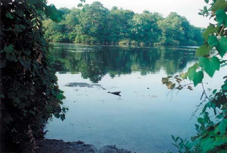
7 Eastport community identified assets: East Pond, West Pond, small town charm, historic buildings, historic church/cemetery at center of community, antique stores, bed and breakfasts, Town Trustee dock/waterfront area, pine barrens woodland and nurseries (agricultural lands) on Old Country Road - rural ambiance, farmland views from Montauk Highway behind historic homesteads. COMMUNITY CHARACTER PHOTO EXHIBITS: EASTPORT vii


")


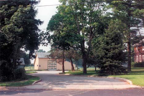
8 Speonk community identified assets: Historic train station in hamlet center, historic old mill, greenspace at community crossroads at Speonk River (East Gateway) and intersection with Dock Road/South Country Road (West Gateway), mixed uses and affordable housing in hamlet center; houses converted to small-scale commercial uses, pine barrens woodland and nurseries, pumpkin farm (agricultural lands) on Old Country Road; rural ambience; greenspace along Speonk-Riverhead Road. COMMUNITY CHARACTER PHOTO EXHIBITS:SPEONK viii Saccardi & Schiff, Inc.


9 Remsenburg community identified assets: Extensive grouping of historic homes, barns, churches; scenic corridor along South Country Road; Stokes Poges wetlands preserve, historic post office at center of community - no commercial businesses; historic yacht squadron and Town Trustee Dock on Speonk Shore Road; equestrian/ gentlemen s farms mixed with residential neighborhoods; narrow roadways/country lanes deter traffic and parking. COMMUNITY CHARACTER PHOTO EXHIBITS: REMSENBURG ix


10 Westhampton community identified assets: Small farms/rural ambiance along Old Country Road together with pine barrens woodland and nurseries (agricultural lands); greenspace/scenic views of community crossroads at intersection of Montauk Highway, Old Country Road; Cook s Pond and waterfront vistas along Montauk Highway and South Country Road; Town Trustee Dock on Baycrest Avenue; historic ambiance of residential neighborhoods; potential for Town Park Recreation Area/campgrounds at The Water Hole ; Hampton West Park; Westhampton Beach Schools; scenic wetland areas and bridges along South Country Road and South Road. COMMUNITY CHARACTER PHOTO EXHIBITS: WESTHAMPTON x Saccardi & Schiff, Inc.


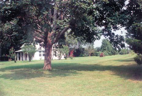
11 COMMUNITY CHARACTER PHOTO EXHIBITS:WESTHAMPTON xi
12 An overview of the Study Area s historical formation is discussed in detail in SECTION III. SECTION IV reviews the existing conditions within the Study Area, including: Natural Features: the distinguishing elements of the environment that help establish the Study Area as a unique place. Pine Barrens A significant portion of the Study Area comprises either Core Preservation Area (approximately 3,300 acres, or 36 percent of the Study Area) or Compatible Growth Area (1,600 acres, or 18 percent.) Aquifer The Study Area, as most of the Town, relies on groundwater as a critical resource. The protection of this resource is of utmost importance. Waterways The waterways in the Study Area are one of the greatest natural assets for both scenic beauty and the ability to provide public access and recreational opportunities for residents and visitors alike. Soils and Topography Specific portions of the Study Area are underlain with prime agricultural soils. The ability to identify and preserve, where appropriate existing agricultural uses is an identified concern. Land Use Patterns: The existing land use pattern reflects past development patterns. Certain land use trends, as envisioned by the community, seek to alter certain identified aspects of local land use. Agriculture Approximately 350 acres, or four percent, of the land use pattern is devoted to active agricultural use. The ability to retain what remains in agriculture use is a priority to the community, as well as encouraging agri-business and eco-tourism opportunities for community heritage purposes. Residential The predominant land use pattern south of Old Country Road is devoted to residential use. The ability to preserve remaining land area through clustering and other design and zoning techniques was identified as a critical community concern. The appropriate location of specific residential land use patterns (e.g., multifamily or senior housing) relative to existing hamlet center core areas was also raised. Recreation/Dedicated Open Space Significant resources within the Study Area are its open space/recreation resources, providing access to significant environmental assets, such as the Central Pine Barrens and Moriches Bay. An interconnected system of trails and pathways has been identified to link many of these resources. Commercial Commercial uses are primarily focused along the Montauk Highway corridor in each of the Hamlet Areas. The land use pattern for the most part, reflects the small-scale mixed-use pattern serving the local community. Sand Mines and Industrial Four separate former or currently operating sand mines sites exist within the Pine Barrens region within the Study Area. Separate light industrial areas exist along North Phillips Avenue, Speonk-Riverhead Road, and Old Riverhead Road. For these pre-existing nonconforming mining sites and some of these industrial uses, their re-development or adaptive re-use must be contemplated with respect to their impact on the environment and the ability to create employment and enhance the existing tax base, or provide recreational opportunities. xii Saccardi & Schiff, Inc.
13 Vacant Land The majority of the vacant properties within the Study Area are located north of Old Country Road in the Central Pine Barrens. Significant parcels south of Old Country Road have also been identified and potential opportunities for these sites are discussed further in Sections VI and VII. Zoning: A summary of the different zoning districts is provided together with a list of permitted uses and selected dimensional requirements for mapped districts within the Study Area. Community Facilities: Descriptions of the community facilities serving the Study Area include schools, fire districts, ambulance districts, Westhampton Community Center, Town of Southampton Solid Waste Transfer Station and Recycling Center, and the Suffolk County Airport (Gabreski Airport). Demographics and Housing: An evaluation of demographic trends in population and housing is provided, based on U.S. Census data. The trends and demographic information points to specific shifts in the Study Area s population relative to overall population growth, change in specific age cohorts, seasonal versus year-round housing, household size and income. Visual Resources: One of the most compelling resources the Study Area has to offer are its visual attributes. Among those areas evaluated include: Scenic Roadway Corridors Old Country Road, Montauk Highway, South Country Road (Main Street), and Sunrise Highway; Viewsheds of Local Importance including remaining agricultural tracts and historic farmsteads, wetlands and waterbodies; and Historic Resources - relevant examples of the Study Area s built environment includes many of the Study Area more historic structures, such as residences, the brick mill, churches, farm buildings and barns. SECTION V addresses tax equity concerns in the Study Area and provides a build-out analysis based upon school district boundaries within the Study Area. The build-out analysis assists the community in determining a conceptual baseline of potential development that could occur within the designated areas under current zoning conditions. This section also addesses implementation of the state-approved Central Pine Barrens Plan, which is a goal noted in the 1999 Comprehensive Plan Update. SECTION VI addresses the Issues and Opportunities presented in the Study Area, which includes a series of properties or Areas Subject to Change where development/ redevelopment was potentially identified. For example, there are four sand mines located within the Study Area with mining permits issued by the New York State Department of Environmental Conservation that have either expired or are set to expire in the near future. These large parcels potentially provide the opportunity for needed recreational uses on lands that have already been cleared, therefore minimizing the need to clear untouched lands. Another example of an area subject to change is the old Feather Factory site on the west side of North Phillips Avenue in Speonk. Redevelopment of this ±15-acre disturbed site provides the opportunity for increased tax base for the Eastport School District. The Issues and Opportunities section of this report also provides information on preservation priorities, (including the Water Hole, agricultural lands along Old Country Road, etc.), the utilization of incentive zoning, housing issues and opportunities, recreational resources, community services, transportation issues, and energy use. xiii
14 SECTION VII sets forth Detailed Hamlet Area Concept Plan Proposals with specific recommendations with respect to: Land Use Controls/ Smart Growth ; Proposed Zoning Map Amendments for Hamlet Office/Hamlet Commercial (HO/HC and others); Eastport Detail Hamlet Area Concept Plan; Speonk-Remsenburg Detail Hamlet Area Concept Plan; Westhampton Detail Hamlet Area Concept Plan; Preliminary Design Guidelines/Streetscape Recommendations; Agricultural Resource Protection Strategies; Scenic Resource Protection Strategies; and Historic Resource Protection Strategies. SECTION VIII then outlines a summary of the proposed Action Items. AREA STUDY GOALS AND OBJECTIVES The following Goals and Objectives were identified through the extensive planning analysis and citizen involvement process associated with this Area Study: Preservation of Community Character While this Area-Wide Study aims to determine appropriate land use and identify means of increasing the area s tax base, a key goal is to preserve the existing, primarily residential character of the hamlets, the area s scenic resources and the general country ambiance. See Community Character Exhibits. Preservation of Open Space The Central Pine Barrens Act has preserved a large swath of environmentallysensitive acreage from development. There is, however, a recognition that the overall appearance of the Study Area would be profoundly affected if development were left unchecked on remaining large vacant parcels. One goal of the Area-Wide Study is to preserve significant open space, through the use of Community Preservation Fund (CPF) monies, design techniques such as clustering and other zoning strategies, such as transfer of development rights and overlay districts. See Exhibit VI-3, Proposed Recreation/Open Space Resource Enhancements. Agricultural Land Preservation - Related to the above referenced issue is the preservation of the community=s remaining agricultural lands. Agricultural uses represent an historic reminder of the land use pattern that once predominated and still contributes to the Study Area s open space aesthetic and rural quality. See Section VII, Agricultural Resource Protection Strategies. Community Housing The creation of affordable, community-based housing targeted towards Town residents, municipal employees, school district employees, volunteer fire fighters and ambulance workers and the like has been broadly recognized as a desirable goal for the area. Affordable housing should be provided as a component in residential development projects or created through specific zoning and regulatory techniques. To the extent practicable, and in keeping with Smart Growth principles, there should be a particular focus on locating higher-density prototypes in proximity to hamlet commercial centers. To preserve community character, subject to the constraints of economic feasibility, small-scale housing developments are preferred, as are design techniques such as manor houses and zoning strategies such as accessory apartments. See Section VII, Housing Issues and Opportunities. Design - Future development and redevelopment should focus on historic design precedents, use of quality materials and sensitive design techniques, incorporating aesthetically pleasing materials such as wood, brick and stone. Existing historic residential design can be used as a guideline for future residential development. See Section VII, Preliminary Design Guidelines. xiv Saccardi & Schiff, Inc.
15 Transportation - Transportation routing should reflect the preservation of the scenic qualities of the Study Area and alternative access ways (e.g., contemplated new interchange at Speonk-Riverhead Road/Sunrise Highway and potential extension of the Sunrise Highway Service Road from the Eastport Manorville Road exit to Speonk-Riverhead Road). Emphasis should be given to pedestrian orientation in the form of traffic calming, transit-oriented facilities, and creation/signage of bicycle routes throughout the Study Area. See Exhibit VI-8, Preliminary Transportation Recommendations. Seasonally Based Economy - The Study Area depends, in large part, on the seasonal resident. The Area-Wide Study attempts to create additional resort area amenities that would enhance the recreational amenities currently available, and provide new recreational opportunities, which could include eco-tourism as a means of promoting future economic development. These potential new recreation/tourism amenities are intended not only to attract seasonal residents but also to meet the needs of the year-round residents. See Exhibit VI-1, Issues and Opportunities. Groundwater Protection - Groundwater protection is a vital issue due to the sole source aquifer system serving this portion of Suffolk County. Where appropriate, state of the art stormwater management systems and organic technology (e.g., golf course design) should be employed. Further, at those locations where there is known/suspected groundwater contamination there should be given a priority for redevelopment with the goal of remediating the existing adverse environmental condition. See Exhibit IV-2, Aquifer Protection Overlay District. Scenic Resource Protection - As illustrated in the photo exhibits included as part of this report, there are significant scenic resources located throughout the Study Area. Preservation of identified area gateways, scenic roadways, and important community vistas should be a priority. The use of scenic roadway designations and Scenic Resource Protection Overlay Zones should be considered, in particular for Old Country Road. Historic Resource Protection An inventory of the Study Area s historic resources was commissioned by the Town during the course of this Planning Study and the report entitled Historic Profiles of Eastport- Speonk-Remsenburg-Westhampton is included in Appendix B. 1 Each hamlet area has a concentration of historically significant sites. The Town should consider establishing Historic Heritage Areas for Eastport, Speonk- Remsenburg, Westhampton and other historic resource protection strategies involving Special Character Overlay Districts. See Section VII and Exhibit III-1, Potential Hamlet Heritage Areas and Historically Significant Sites. The Area Study planning initiative is just the beginning. The key is implementation. To achieve the goals and objectives outlined herein, Town Officials, landowners, community organizations and residents need to work together to continue to build consensus and help bring the vision to fruition. 1 The report entitled Historic Profiles of Eastport, Speonk-Remsenburg and Westhampton was completed in January 2004 under a separate consulting agreement with local historians Ron A. Michne and Ron A. Michne, Jr. xv
AREA STUDY Eastport, Speonk-Remsenburg, Westhampton Revised. Master List of Edits
 AREA STUDY Eastport, Speonk-Remsenburg, Westhampton 7-13-04 Revised Master List of Edits underlines and Red Font are additions strike-outs are deletions Acknowledgements Sources Other Table of Contents
TABLE OF CONTENTS. Transportation Chapter 1 - Introduction and Purpose of Planning to 1-3. Utilities
 Chapter 1 - Introduction and Purpose of Planning... 1-1 to 1-3 Pennsylvania Municipalities Planning Code (Act 247)...1-1 Previous County Planning Activities...1-1 Objectives of the Plan...1-2 Elements
Town of Peru Comprehensive Plan Executive Summary
 Town of Peru Comprehensive Plan Executive Communities that plan grow by choice, not by chance. A plan makes growth thoughtful, understandable, and predictable. A plan shows that a community is managing
A Growing Community Rural Settlement Areas
 Town of Huntsville Official Plan Review - POLICY BACKGROUND PAPER A Growing Community Rural Settlement Areas BACKGROUND: In addition to the fully municipally-serviced Urban Settlement Area and the Hidden
Town of Blooming Grove Comprehensive Plan. Public Meeting October 13, 2004
 Town of Blooming Grove Comprehensive Plan Public Meeting October 13, 2004 Overview of Presentation Process Plan Vision Recommendations Next Steps Process: Listening to the Public Monthly meetings with
6 PORT SYDNEY SETTLEMENT AREA
 Section 6 Port Sydney Page 61 6 PORT SYDNEY SETTLEMENT AREA 6.1 Basis and Principles Village of Port Sydney Waterfront Community Existing Services 6.1.1 Port Sydney is an historic settlement that has developed
BROOKHILL NEIGHBORHOOD MODEL ZONING MAP AMENDMENT PREFACE TO APPLICATION
 BROOKHILL NEIGHBORHOOD MODEL ZONING MAP AMENDMENT PREFACE TO APPLICATION June 15, 2015 Revised: August 1, 2016 I. VISION Brookhill is a proposed community based upon the principles of Albemarle County
TOWN OF BRUDERHEIM Report to the capital region board
 TOWN OF BRUDERHEIM Report to the capital region board Introduction to the Town of Bruderheim Municipal Development Plan amendment and Relation to the CRB Evaluation Criteria 02 march 2017 1 Introduction
AREASTRUCTURE PLAN AMENDMENT COCHRANE NORTH
 AREASTRUCTURE PLAN AMENDMENT COCHRANE NORTH In order to implement the vision outlined in the Conceptual Scheme, the following three amendments to the Cochrane North ASP are proposed: 1. Allow commercial
This page intentionally blank.
 This page intentionally blank. Parks, Recreation, and Open Space Chapter Relationship to Vision Vision Parks, Recreation and Open Space Chapter Concepts County Government. County government that is accountable
SECTION 1 Introduction...1. SECTION 2 Regional Context Criteria for Planning Districts Description of Planning District...
 Table of Contents SECTION 1 Introduction...1 SECTION 2 Regional Context...2 2.1 - Criteria for Planning Districts...2 2.2 - Description of Planning District...2 SECTION 3 Goals & Objectives...5 SECTION
TREASURE COAST REGIONAL PLANNING COUNCIL M E M O R A N D U M. To: Council Members AGENDA ITEM 5I
 TREASURE COAST REGIONAL PLANNING COUNCIL M E M O R A N D U M To: Council Members AGENDA ITEM 5I From: Date: Subject: Staff December 12, 2008 Council Meeting Local Government Comprehensive Plan Review Town
Secrest Short Cut and Monroe Expressway Small Area Plan AUGUST 29, 2018
 Secrest Short Cut and Monroe Expressway Small Area Plan AUGUST 29, 2018 Background and Process Monroe Expressway will be open by the end of 2018 Union County and Indian Trail identified a need to revisit
Chapter 10 IMPLEMENTATION RECOMMENDATIONS
 Chapter 10 IMPLEMENTATION RECOMMENDATIONS The recommended land use plan presented in the previous chapter provides a design for the attainment of the urban and rural development and open space preservation
EXECUTIVE SUMMARY DRAFT CHAPTER 1 INTRODUCTION EXECUTIVE SUMMARY
 CHAPTER 1 EXECUTIVE SUMMARY INTRODUCTION Through the joint efforts of the City of Tulsa planning staff and the Land Services division of Indian Nations Council of Governments (INCOG), the Berryhill Land
495/MetroWest Development Compact Plan Citizen Planner Training Collaborative Conference. March 17, 2012
 495/MetroWest Development Compact Plan Citizen Planner Training Collaborative Conference March 17, 2012 Project Process Local and Regional Priority Areas Growth Scenarios Transportation Investment Categories
EXISTING COMPREHENSIVE PLAN
 EXISTING COMPREHENSIVE PLAN Town Center Land Use Element: V. LAND USE POLICIES Town Center Mercer Island's business district vision as described in "Your Mercer Island Citizen-Designed Downtown" was an
WATERFORD Plan of Preservation, Conservation and Development Supplement Part 1 - Policy Element
 WATERFORD 2012 Plan of Preservation, Conservation and Development 2015 Supplement Part 1 - Policy Element Effective June 11, 2015 2015 Plan Update GOAL To respond to the evolving land use needs and continually
LAND USE ELEMENT. Purpose. General Goals & Policies
 LAND USE ELEMENT Purpose This Land Use Element contains the goals and policies necessary to support the City s responsibility for managing land resources and guiding development through implementing regulations,
9 th Street Sub Area Plan
 9 th Street Sub Area Plan In the 1990 s, when the Township prepared the last Master Plan, the 9 th Street corridor was studied as part of a larger 9 th Street Focus Area that included the West Main Street
HOT SPRINGS COMPREHENSIVE PLAN OUTLINE
 HOT SPRINGS COMPREHENSIVE PLAN OUTLINE 7/28/2015 Draft outline - Hot Springs Comprehensive Plan Draft outline of topics to be discussed at public hearings and in planning sessions. Order and topics and
S A C R A M E N T O C O U N T Y JACKSON HIGHWAY & GRANT LINE EAST VISIONING STUDY
 JACKSON HIGHWAY & GRANT LINE EAST S A C R A M E N T O C O U N T Y P L A N N I N G D E P A R T M E N T SUMMARY AND WORKBOOK November 19, 2008 History of the Visioning Study Sacramento County has two growth
Mark-up of the effect of the proposed Bronte Village Growth Area OPA No.18 on the text of section 24, Bronte Village, of the Livable Oakville Plan
 Mark-up of the effect of the proposed Bronte Village Growth Area OPA No.18 on the text of section 24, Bronte Village, of the Livable Oakville Plan Notes: This document is provided for information purposes
City of Heath. Town Center Concept
 In the give-and-take of getting projects designed, financed, and approved, the famous refrain from the film Field of Dreams is heard often: if you build it, they will come. From the perspective of the
Chapter IV: Development Pattern
 Chapter IV: Development Pattern Introduction The 2002 Prince George s County Approved General Plan designates three growth policy tiers Developed, Developing, and Rural as well as three center designations
13. VANDORF-PRESTON LAKE SECONDARY PLAN 13.1 INTRODUCTION
 13. VANDORF-PRESTON LAKE SECONDARY PLAN 13.1.1 Purpose 13.1 INTRODUCTION The Vandorf-Preston Lake Secondary Plan establishes the principles, objectives and general policies, as well as specific strategies
Sorted citizen input comments in review of Blount County plans July, August, and September 2007
 Sorted citizen input comments in review of Blount County plans July, August, and September 2007 The following presents sorted citizen input comments from three sessions held in July, August and September
IV. Development in the Rural Overlay District
 Intracoastal Waterway Route 17 Route 168 Great Dismal Swamp VIRGINIA NORTH CAROLINA IV. Development in the Rural Overlay District IV-1 Route 17 in Chesapeake s Rural Overlay District affords distant views
City of Farmington. Downtown Plan. Amendment to the 1998 Master Plan Adopted October 11, 2004
 City of Farmington Amendment to the 1998 Master Plan Adopted October 11, 2004 Introduction Planning Background 1 Scope and Components of the Plan Amendment 2 Concept Introduction 3 Plan Concepts 3 Conceptual
Rural Conservation. Rural Conservation. Moving Forward ~ Planning Ahead. Introduction
 Introduction Minnehaha County expresses at least two very different styles of character. The City of Sioux Falls provides a strong urban atmosphere because of its size and regional status, and the unincorporated
G. RECREATION AND OPEN SPACE ELEMENT. The following summarizes the Recreation and Open Space Element:
 G. RECREATION AND OPEN SPACE ELEMENT The purpose of the Element is to provide the framework and direction for a comprehensive system of public and private sites for recreation, including, but not limited
Urban Design Brief Woodland Cemetery Funeral Home 493 Springbank Drive
 Urban Design Brief Woodland Cemetery Funeral Home The Incorporated Synod of the Diocese of Huron April 15, 2016 Urban Design Brief April 15, 2016 TABLE OF CONTENTS Page No. INTRODUCTION... 1 SECTION 1
Further input invited as Colchester Growth Strategy nears final phase
 IUE 3 / NOVEMBER 2015 Further input invited as Colchester Growth trategy nears final phase trathcona County is seeking public feedback as it enters the final phase of work on a Growth Management trategy
4-Town Comprehensive Plan DRAFT 7/30/07
 4-Town Comprehensive Plan DRAFT 7/30/07 Acknowledgements ning Committee Town of Harrisburg Norman Roof Randy Nicol Town of Martinsburg Terry Thisse Paul Kelly Town of Montague Jan Bagdanowicz Wendy Perry
3.10 LAND USE SETTING PROJECT SITE EXISTING LAND USE DESIGNATIONS AND ZONING. General Plan Land Use Designations.
 This section of the Draft EIR addresses the existing land uses on and adjacent to the project site and discusses the potential impacts of the proposed project on existing land uses. Key issues addressed
Chapter Master Planned Communities (MPC) District
 District") Sections 14.53.010 Purpose and Intent 14.53.020 Applicability 14.53.030 Procedure 14.53.040 MPC Standards 14.53.050 Required Findings 14.53.010 Purpose and Intent Chapter 14.53 Master Planned Communities
Sections 14.53.010 Purpose and Intent 14.53.020 Applicability 14.53.030 Procedure 14.53.040 MPC Standards 14.53.050 Required Findings 14.53.010 Purpose and Intent Chapter 14.53 Master Planned Communities
ELMVALE ACRES SHOPPING CENTRE MASTER PLAN
 ELMVALE ACRES SHOPPING CENTRE MASTER PLAN Contents 1.0 INTRODUCTION... 2 2.0 LOCATION... 2 3.0 EXISTING CONTEXT... 2 4.0 VISION & GUIDING PRINCIPLES... 2 5.0 LAND USE AND BUILT FORM... 4 5.1 St. Laurent
Draft Stillwater 2030 Comprehensive Plan- Goals and Policies
 Draft Stillwater 2030 Comprehensive Plan- Goals and Policies Instructions- Review each goal and policy and discuss with group any changes, deletions for additions to the list using your groups pen. Keep
Cumberland Comprehensive Plan Town Council adopted August 2003, State adopted June 2004 TABLE OF CONTENTS
 TABLE OF CONTENTS I. Executive Summary A. Scope of the Comprehensive Plan I-2 B. Plan Development Process I-3 C. Plan Format I-3 D. Acknowledgements I-4 II. Demographic Analysis A. Introduction II-1 B.
2010 Plan of Conservation and Development
 2010 Plan of Conservation and Development Wilton Planning and Zoning Commission Adopted November 2, 2009 Effective January 1, 2010 WILTON 2010 PLAN OF CONSERVATION & DEVELOPMENT PARTICIPANTS Planning &
DRAFT SCOPE FOR THE DRAFT ENVIRONMENTAL IMPACT STATEMENT FOR HUDSON HIGHLANDS RESERVE TOWN OF PHILIPSTOWN, NEW YORK June 5, 2018
 DRAFT SCOPE FOR THE DRAFT ENVIRONMENTAL IMPACT STATEMENT FOR HUDSON HIGHLANDS RESERVE TOWN OF PHILIPSTOWN, NEW YORK June 5, 2018 Project Name: Project Location SEQRA Classification of Project: Lead Agency:
Growing Community Urban Settlement Area and Hidden Valley Settlement Area
 Town of Huntsville Official Plan Review - POLICY BACKGROUND PAPER Growing Community Urban Settlement Area and Hidden Valley Settlement Area BACKGROUND: Through the Provincial Policy Statement (PPS), the
Proposed Comprehensive Plan Strategies DRAFT for discussion June 28, 2017
 Proposed Comprehensive Plan Strategies DRAFT for discussion June 28, 2017 Land Use Rural Areas Refine the Farm and Forest area (FF) Update FF boundaries to account for existing lots less than five acres
A. WHAT IS A GENERAL PLAN?
 I. Introduction A. WHAT IS A GENERAL PLAN? A general plan is the planning guideline for the future of a city. It contains goals and policies which regulate urban development, the protection of the natural
This chapter describes the purpose of the Plan, introduces how the Plan is organized and provides contextual background for the Plan.
 Chapter 1: INTRODUCTION Purpose of a Comprehensive Plan The 2040 Comprehensive Plan establishes Medina s vision as a community and sets goals and objectives which guide future decisions and policies. The
Policies and Code Intent Sections Related to Town Center
 Policies and Code Intent Sections Related to Town Center The Town Center Vision is scattered throughout the Comprehensive Plan, development code and the 1994 Town Center Plan. What follows are sections
THREE-STEP DESIGN PROCESS FOR OPEN SPACE SUBDIVISIONS
 00216106.DOC NMA/RRK 1/30/14 THREE-STEP DESIGN PROCESS FOR OPEN SPACE SUBDIVISIONS Open space subdivisions, sometimes called cluster developments, maintain a significant portion of a development site in
Westport Master Plan. Town of Westport. Master Plan Master Plan Update Committee. Westport, Massachusetts
 Town of Westport Master Plan 2004 Master Plan Update Committee Westport, Massachusetts Open Space and Recreation 5-1 Table of Contents Table of Contents... i List of Tables... ix List of Figures... ix
Selected Area Study. Vision Plan Draft
 East Polk County Selected Area Study Draft 10.30.08 Contents Guiding Principles...4 Context Conclusions...5 Current Context...8 Scenarios...9 Scenario: Status Quo...10 Scenario: Connected & Directed Growth...12
2025 COMPREHENSIVE PLAN PASCO COUNTY, FLORIDA
 GOAL FLU 6: PASADENA HILLS FUTURE LAND USE: PASADENA HILLS AREA PLAN GOALS, OBJECTIVES, AND POLICIES PASADENA HILLS AREA PLAN: OVERVIEW The Pasadena Hills Area Plan Goals, Objectives, and Policies are
3. VISION AND GOALS. Vision Statement. Goals, Objectives and Policies
 Vision Statement Queen Creek s interconnected network of parks, trails, open spaces and recreation opportunities provide safe and diverse activities and programs that sustain its unique, small town, equestrian
RECREATION AND OPEN SPACE ELEMENT GOALS, OBJECTIVES, AND POLICIES
 RECREATION AND OPEN SPACE ELEMENT GOALS, OBJECTIVES, AND POLICIES Goal 7 To provide park facilities, recreation programs, and open space resources that are safe, adequate, and accessible to all City residents,
IMPLEMENTING SOMERSET COUNTY S INVESTMENT FRAMEWORK
 IMPLEMENTING SOMERSET COUNTY S INVESTMENT FRAMEWORK SMART CONSERVATION THROUGH SMART GROWTH NJ LAND CONSERVATION RALLY March 22, 2014 Laurette Kratina, PP, AICP, Supervising Planner Somerset County Planning
Comprehensive Development Guide
 INDUSTRIAL ELEMENT Comprehensive Development Guide 1 Industrial Element 7.1 Hardin County Industrial Overview BG PKWY Fort Knox Industrial Corridor Comprised of 11 parcels totaling 720 acres of land 68
THE COMMUNITY-DRIVEN DESIGN PROCESS
 THE COMMUNITY-DRIVEN DESIGN PROCESS A PUBLIC DRIVEN PROCESS STEERING COMMITEE THE COMPREHENSIVE PLAN OPPORTUNITIES AND CONSTRAINTS THE COMMUNITY DRIVEN DESIGN PROCESS A Public Driven Process Beginning
Mississippi Skyway Preliminary Engineering Report
 EXECUTIVE SUMMARY Mississippi Skyway Preliminary Engineering Report CITY OF RAMSEY, MINNESOTA DECEMBER 2014 City of RAMSEY EXECUTIVE SUMMARY Project Need and Intent The Mississippi Skyway pedestrian bridge
Ten Mile Creek Planning Area
 PLANNING AREA POLICIES TEN MILE CREEK Ten Mile Creek Planning Area Location and Context The Ten Mile Creek Planning Area ( Ten Mile Creek area ) is located south of the current Boise AOCI, generally south
Town Center (part of the Comprehensive Plan)
") Town Center (part of the Comprehensive Plan) Mercer Island Town Center Looking North (2014) In 1994, a year-long process culminated in a set of design guidelines and code requirements for the Town Center
Town Center (part of the Comprehensive Plan) Mercer Island Town Center Looking North (2014) In 1994, a year-long process culminated in a set of design guidelines and code requirements for the Town Center
Dwelling Units Max 12 dwelling units per acre/min 8 dwelling units per acre. Development Mix 80% non residential/20% residential
 13. OSTEEN LOCAL PLAN Background: The Osteen Local Plan area is located in southwest Volusia County along the SR 415 corridor between Lemon Bluff Road and Acorn Lake Road and includes 3,990 acres. The
Be it enacted by the Town Board of the Town of Guilderland that the following new A (Transit Oriented Development (TOD) District) is adopted:
 District) is adopted:") Local Law No. 4 of 2018 (Adoption of 280-18A (Transit Oriented Development District) Be it enacted by the Town Board of the Town of Guilderland that the following new 280-18A (Transit Oriented Development
Local Law No. 4 of 2018 (Adoption of 280-18A (Transit Oriented Development District) Be it enacted by the Town Board of the Town of Guilderland that the following new 280-18A (Transit Oriented Development
Chapter 2: Vision, Goals and Strategies
 Chapter 2: Vision, Goals and Lake Elmo Today & Tomorrow Comprehensive Plan 2040 2 VISION, GOALS & STRATEGIES - DRAFT 4-6-2018 INTRODUCTION Comprehensive Plan Purpose Perhapse the most important objective
Scope of Services. River Oaks Boulevard (SH 183) Corridor Master Plan
 Corridor Master Plan") Scope of Services River Oaks Boulevard (SH 183) Corridor Master Plan PROJECT AREA The project area consists of the River Oaks Boulevard (SH 183) corridor bounded by SH 199 at the northern end and the Trinity
Scope of Services River Oaks Boulevard (SH 183) Corridor Master Plan PROJECT AREA The project area consists of the River Oaks Boulevard (SH 183) corridor bounded by SH 199 at the northern end and the Trinity
Report to: Development Services Committee Report Date: April 24, 2017
 SUBJECT: Cornell Rouge National Urban Park Gateway - Report on Design Charrette and Next Steps PREPARED BY: Lilli Duoba, MES, MCIP, RPP, Manager, Natural Heritage (ext. 7925) REVIEWED BY: Marg Wouters,
I. STAFF POLICY RECOMMENDATIONS. The following RMP policy strategies are proposed by staff in support of a Scenic Resource Protection Program:
 Policy Consideration: Scenic Resource Protection Program Status: For Consideration by the Highlands Council at September 14, 2006 Work session Date: September 12, 2006 I. STAFF POLICY RECOMMENDATIONS The
CHAPTER 7: Transportation, Mobility and Circulation
 AGLE AREA COMMUNITY Plan CHAPTER 7 CHAPTER 7: Transportation, Mobility and Circulation Transportation, Mobility and Circulation The purpose of the Transportation, Mobility and Circulation Chapter is to
Municipal Plan*Assessment
 Municipal Plan*Assessment This tool was developed to assist in reviewing municipal master plans and in determining if these plans are consistent with smart growth principles, neighboring municipal plans,
RECREATION, OPEN SPACE AND GREENWAYS ELEMENT GOALS, OBJECTIVES, AND POLICIES
 RECREATION, OPEN SPACE AND GREENWAYS ELEMENT GOALS, OBJECTIVES, AND POLICIES GOAL R-1: DEVELOP A RECREATION, OPEN SPACE AND GREENWAYS SYSTEM AS AN INTEGRAL COMPONENT OF AN OVERALL, COUNTY-WIDE ECONOMIC
Comprehensive Plan ADOPTED APRIL 2014
 Comprehensive Plan ADOPTED APRIL 2014 8 8. Outstanding Recreational & Cultural Opportunities We are proud of our community s parks and recreation system. Our community will ensure that the legacy of our
Albert Lea. Redevelopment Plan. 701 Xenia Avenue South, Suite 300 Minneapolis, MN Tel: (763) Fax: (763) wsbeng.
 Fax: (763) wsbeng.") Albert Lea Redevelopment Plan 701 Xenia Avenue South, Suite 300 Minneapolis, MN 55416 Tel: (763) 541-4800 Fax: (763) 541-1700 wsbeng.com Albert Lea Redevelopment Plan Table of Contents Composite Districts...
Albert Lea Redevelopment Plan 701 Xenia Avenue South, Suite 300 Minneapolis, MN 55416 Tel: (763) 541-4800 Fax: (763) 541-1700 wsbeng.com Albert Lea Redevelopment Plan Table of Contents Composite Districts...
VILLAGE & TOWN OF BERGEN: COMPREHENSIVE PLAN
 VILLAGE & TOWN OF BERGEN: COMPREHENSIVE PLAN CPC Public Hearing April 21, 2016 History 1996 Comprehensive Plan Comprehensive Plan Update Committee Consultant (LaBella Associates): December 2014 Residents
Brice Prairie Master Plan
 Brice Prairie Master Plan Town of Onalaska Community Meeting #1 Sand Lake Elementary School January 28, 2006 9 am 11 am Agenda Background What is a Master Plan? Brice Prairie Capacity Reports Starter Ideas
COMMUNITY DESIGN. GOAL: Create livable and attractive communities. Intent
 COMMUNITY DESIGN Intent An attractive, well-designed County will attract quality development, instill civic pride, improve the visual character of the community, and create a strong, positive image for
PORT WHITBY COMMUNITY
 PORT WHITBY COMMUNITY SECONDARY PLAN UPDATE COMMUNITY IMPROVEMENT PLAN URBAN DESIGN GUIDELINES September 2015 DRAFT PROPOSED AMENDMENT NUMBER # to the Whitby Official Plan PURPOSE: The intent of this Amendment
TREASURE COAST REGIONAL PLANNING COUNCIL M E M O R A N D U M. To: Council Members AGENDA ITEM 5H
 TREASURE COAST REGIONAL PLANNING COUNCIL M E M O R A N D U M To: Council Members AGENDA ITEM 5H From: Date: Subject: Staff October 17, 2008 Council Meeting Local Government Comprehensive Plan Review Draft
Small Area Plan. South Gateway
 Small Area Plan Adopted May 12, 2008 South Gateway Purpose. The South Gateway Small Area Plan defines the City s expectations for the future of the southern entrance to the City at Interstate 85 and Highway
CHARLES PUTMAN CHARLES PUTMAN AND ASSOCIATES, INC
 MEMORANDUM CHARLES PUTMAN & ASSOCIATES, INC. LAND DEVELOPMENT CONSULTANTS PLANNING ZONING PERMITTING 4722 NW Boca Raton Boulevard, Suite C-106 Boca Raton, Florida 33431 Phone: 561/994-6411 FAX: 561/994-0447
New-Cast Mixed-use Development Proposal King Street West, Newcastle, Ontario
 URBAN DESIGN BRIEF New-Cast Mixed-use Development Proposal King Street West, Newcastle, Ontario TABLE OF CONTENTS: 1.0 Executive Summary 2.0 Creating Vibrant and Sustainable Urban Places: Excerpts from
Subject: Hendry County Evaluation and Appraisal Report Letter of Understanding - Identification of Major Issues
 HENDRY COUNTY PLANNING & ZONING DEPARTMENT POST OFFICE BOX 2340 165 S. LEE STREET LABELLE, FLORIDA 33975 (863) 675-5240 FAX: (863) 675-5317 SUNCOM 744-4750 November 16, 2007 Mr. Mike McDaniel, Chief Office
ELK GROVE GENERAL PLAN VISION
 2-1 CHAPTER 2: 2-2 CREATING OUR The Community Vision for Elk Grove, expressed through a Vision Statement and a series of Supporting Principles, is a declaration of the kind of community that Elk Grove
2025 COMPREHENSIVE PLAN PASCO COUNTY, FLORIDA
 GOAL FLU 6: PASADENA HILLS FUTURE LAND USE: PASADENA HILLS AREA PLAN GOALS, OBJECTIVES, AND POLICIES PASADENA HILLS AREA PLAN: OVERVIEW The Pasadena Hills Area Plan Goals, Objectives, and Policies are
NEW CASTLE COUNTY S ZONING DISTRICTS
 NEW CASTLE COUNTY S ZONING DISTRICTS This is general information about New Castle County s zoning districts. The information included is by no means exhaustive or complete. Before designing plans to develop
DAVENPORT VILLAGE SECONDARY PLAN
 27 DAVENPORT VILLAGE SECONDARY PLAN 27. DAVENPORT VILLAGE SECONDARY PLAN 1. VISION FOR THE DAVENPORT VILLAGE SECONDARY PLAN Davenport Village, municipally known as 830, 940, 980 and 1100 Lansdowne Avenue,
REQUEST FOR QUALIFICATIONS
 REQUEST FOR QUALIFICATIONS VILLAGE OF HAMBURG COMPREHENSIVE ZONING/LAND USE REGULATIONS UPDATE Prepared By: Village of Hamburg 100 Main Street Hamburg, New York 14075 Village of Hamburg RFQ Page 1 of 10
Pine Island Road Corridor Master Plan
 RECOMMENDED DEVELOPMENT PLAN Figure 9: Del Prado Village District Conceptual Framework The Conceptual Framework (Figure 8) for development of the Pine Island Corridor is to encourage mixed-use development
OVERVIEW OF PLANS FOR THE JEFFERSON COUNTY COUNTRYSIDE FARM In the Context of Quality Place Characteristics
 OVERVIEW OF PLANS FOR THE JEFFERSON COUNTY COUNTRYSIDE FARM In the Context of Quality Place Characteristics By Steve Grabow, Professor and Community Development Educator University of Wisconsin-Extension,
2018 Northampton Township Comprehensive Plan
 2018 BUCKS COUNTY, PENNSYLVANIA What is a? A comprehensive plan is a municipality s main policy document that details the collective vision for the future, the historic, environmental, and cultural facilities
Chapter 6: Community Character
 Chapter 6: Community Character The term "community character" covers a broad spectrum of concerns. First and foremost, community character is a visual concept. In Long Grove, however, community character
7Page 1 CLEMMONS COMMUNITY COMPASS 1 PLAN OVERVIEW
 1 Plan Overview WHAT IS I THE CLEMMONS COMMUNITY COMPASS? The Clemmons Community Compass is our community s comprehensive plan. It serves as our blueprint and provides direction for the future of the Village
Transportation. Strategies for Action
 Transportation A major priority for the Overlake Neighborhood is to develop a multimodal transportation system. To achieve this system, a balance has to be found among travel, circulation and access needs;
EXHIBIT A. Tax Increment Reinvestment Zone No. 1 (Town Center) First Amended Project Plan 1
 First Amended Project Plan 1") EXHIBIT A Tax Increment Reinvestment Zone No. 1 (Town Center) First Amended Project Plan 1 1 As amended by Resolution No. 2008-02-001(TR1R) of the Tax Increment Reinvestment Zone No.1, and approved to
EXHIBIT A Tax Increment Reinvestment Zone No. 1 (Town Center) First Amended Project Plan 1 1 As amended by Resolution No. 2008-02-001(TR1R) of the Tax Increment Reinvestment Zone No.1, and approved to
City Center Neighborhood Plan
 [1] City Center Neighborhood Plan As adopted by Ordinance No. 2014-09-049 and amended by Ordinance Nos. Formerly CBD Neighborhood as adopted by Ordinance No. 8868 and amended by Ordinance Nos. 8946, 9693,
CHAPTER 4 - LAND USE CLASSIFICATIONS
 CHAPTER 4 - LAND USE CLASSIFICATIONS Four new land use classification categories are established in the Gualala Town Plan: Gualala Village Mixed Use; Gualala Highway Mixed Use; Gualala Planned Development
DISCUSSION TOPIC: ST JOHNS RIVER & ITS TRIBUTARIES (BPII) 2030 COMPREHENSIVE PLAN POLICES AND REGULATORY FRAMEWORK
 2030 COMPREHENSIVE PLAN POLICES AND REGULATORY FRAMEWORK") DISCUSSION TOPIC: ST JOHNS RIVER & ITS TRIBUTARIES (BPII) 2030 COMPREHENSIVE PLAN POLICES AND REGULATORY FRAMEWORK St. John s River & Its Tributaries Issue Summary: The St. Johns River is an important
DISCUSSION TOPIC: ST JOHNS RIVER & ITS TRIBUTARIES (BPII) 2030 COMPREHENSIVE PLAN POLICES AND REGULATORY FRAMEWORK St. John s River & Its Tributaries Issue Summary: The St. Johns River is an important
LOS ANGELES CITY PLANNING DEPARTMENT STAFF REPORT
 LOS ANGELES CITY PLANNING DEPARTMENT STAFF REPORT LOS ANGELES CITY PLANNING COMMISSION CASE NO: CPC 2006-9374 CRA CEQA: Exempt DATE: December 21, 2006 Location: Valley Plaza and Laurel Plaza TIME: after
Staff Report and Recommendation
 Community Planning and Development Planning Services 201 W. Colfax Ave., Dept. 205 Denver, CO 80202 p: 720.865.2915 f: 720.865.3052 www.denvergov.org/cpd TO: City Council Neighborhoods and Planning Committee
ESTABLISH AN EFFICIENT TOWN CENTER
 ESTABLISH AN EFFICIENT TOWN CENTER 4 Overview Lisbon residents are proud of the history of Newent and at the same time recognize its current importance as a centralized location for a variety of municipal
CONTENTS 2.0 A FRAMEWORK FOR SUSTAINABLE GROWTH 2.1 MANAGING SUSTAINABLE GROWTH THE VISION TO GOALS AND OBJECTIVES 2.3 MARKHAM STRUCTURE
 2 A Framework for Sustainable Growth 2.0 A FRAMEWORK FOR SUSTAINABLE GROWTH CONTENTS 2.1 MANAGING SUSTAINABLE GROWTH THE VISION TO 2031 2.2 GOALS AND OBJECTIVES 2.2.1 Protecting the Natural Environment
FOSTER COMPREHENSIVE PLAN UPDATE CIRCULATION
 5.8.1 INTRODUCTION CIRCULATION The Circulation Element of the Comprehensive Plan studies the routes and modes of travel. The circulation network of the town affects the ease of movement through Foster
ADMINISTRATION RECOMMENDATION(S) 2018 January 25. That Calgary Planning Commission recommend APPROVAL of the proposed Land Use Amendment.
 2018 January 25. That Calgary Planning Commission recommend APPROVAL of the proposed Land Use Amendment.") Page 1 of 9 EXECUTIVE SUMMARY This land use amendment proposes to redesignate a parcel from DC Direct Control District to Multi-Residential Contextual Grade-Oriented (M-CG) District to allow for multi-residential
Page 1 of 9 EXECUTIVE SUMMARY This land use amendment proposes to redesignate a parcel from DC Direct Control District to Multi-Residential Contextual Grade-Oriented (M-CG) District to allow for multi-residential
Northwest Rail Corridor and US 36 BRT Development Oriented Transit Analysis 4.4 STATION AREA FINDINGS
 4.4 STATION AREA FINDINGS Each station is different, and each one requires a separate set of recommendations based on the vision for the site. This section outlines an initial TOD strategy and recommendations