Chapter 9. Future Land Use. Sarasota County Comprehensive Plan
|
|
|
- Maryann Griffin
- 5 years ago
- Views:
Transcription
1 Chapter 9 Future Land Use Sarasota County Comprehensive Plan
2 Sarasota County Planning & Development Services 1660 Ringling Boulevard 1 st Floor Sarasota, FL Contact Telephone: Web Address: scgov.net Fax Number: Address: planner@scgov.net ii Updated: 17-Nov-06
3 Table of Contents Chapter 9 Future Land Use Introduction Inventory Existing Land Uses Existing Land Covers Growth Trends Analysis Development Capacity of the Urban Area Residential Capacity Analysis Summary of Residential Capacity Analysis Coordination of Capital Improvements and Land Uses Uses on the Barrier Islands Planning for Residential Uses Planning for Commercial Uses Planning for Office and Major Employment Uses Planning for Public and Civic Uses Redevelopment County Planning Programs Summary Future Land Use Plan Guiding Principles Land Use Designations and Implementing Zoning Categories Zoning District Names and Principle Types of Uses Functional Classification of Commercial Centers Updated: 17-Nov-06 iii
4 List of Illustrations Table 9-1: Functional Classification of Commercial Centers Table 9-2: Inventory of Commercial Centers Figure 9-1: Population Trends in Sarasota County and the Unincorporated County, Figure 9-2: Coastal High Hazard Area Figure 9-3: Settlement Area Overlay Figure 9-4: Affordable Housing Overlay Figure 9-5: City of Venice Joint Planning Area Figure 9-6: Special Planning Area Number Figure 9-7: Special Planning Area 2 Medical Boulevard Development9-111 Figure 9-8: Special Planning Area Updated: 17-Nov-06 iv
5 Chapter 9 Future Land Use Introduction The Future Land Use Chapter provides direction for managing anticipated growth in the unincorporated portions of Sarasota County in an orderly and balanced manner. The Future Land Use Plan chapter text and the Future Land Use Map, along with all the other Chapters of the Comprehensive Plan are designed to work in concert and ensure that the distribution of land uses will meet the future economic, social, physical, and environmental needs of Sarasota County. In previous Evaluation and Appraisal Report periods, the planning principles often referred to as Smart Growth principles were not articulated as guiding planning values and incorporated in a meaningful way in the Future Land Use and other Comprehensive Plan chapters. Since the last EAR, Sarasota County has adopted Directions for the Future and a community vision plan entitled Sarasota 2050 both of which are based on the Smart Growth planning principles outlined below. The principles when applied will lead to a diverse and sustainable community with a high quality of life. Preserve and strengthen existing communities Provide for a variety of land uses and lifestyles to support residents of diverse ages, incomes, and family sizes, including housing that is affordable to residents at or below the median income for Sarasota County Preserve environmental systems Direct population growth away from floodplains Avoid Urban Sprawl Reduce automobile trips Create efficiency in planning and provision of infrastructure Provide County central utilities Conserve water and energy Allocate development costs appropriately Preserve rural character, including opportunities for agriculture Balance jobs with housing Planning for a sustainable community is the overarching theme of the Sarasota County Comprehensive Plan. Sarasota County government is committed to lead by example, promote public participation and work in community partnership to improve our quality of life and protect the natural systems that support life. Updated: 17-Nov
6 Chapter 9 For the purpose of the Comprehensive Plan, sustainability is defined as aligning the built environment and socioeconomic activities with the natural systems that support life while meeting the needs of the present generation without compromising the ability of future generations to meet their needs. The Future Land Use Chapter contains several major sections each of which includes a number of subsections. The organization of the chapter as a whole is described below: The Inventory Section provides general data and maps on existing land uses and land covers, and population trends. The maps are provided separately. This section is intended as a short overview or brief snapshot of trends and land use patterns. The Analysis Section is divided into subsections that describe the different types of land uses shown on the Future Land Use Map, methodologies used in determining the distribution of those uses and guidelines governing the uses. The specific topics covered in the subsections include the following: Development capacity of the Urban Area describes the remaining residential development potential within the unincorporated area, and provides data on the development potential of vacant tracts, large scale developments, and vacant platted parcels under the capacity methodology. It also discusses the ongoing initiatives for implementing an annual development monitoring program; Coordination of Capital Improvements and land uses provides directives for long range capital facility planning and references to the Capital Improvements Program for Fiscal Years contained in Chapter 10; Description of the use on the Barrier Islands; Planning for Residential uses describes the low, moderate, medium, and high density residential area designations on the Future Land Use Map. Planning for Commercial uses summarizes the update to the commercial land use designations and inventory from the Future Land Use Map, as amended through 2004; Planning for Office and Major Employment Center uses describes the planning that has been done for areas designated as Major Employment Center locations on the Future Land Use Map, as amended through 2002; Planning for Public and Civic uses describes planning for community facilities such schools, houses of worship, utilities, and government uses The County Planning Programs section describes the types and goals of the different County planning programs. These programs are intended to build community, address development, redevelopment, and infill; and Redevelopment strategies describes specifically how the County will encourage redevelopment and use smart growth principles by establishing flexible regulations and adopting programs that facilitate and support redevelopment activity. 9-6 Updated: 17-Nov-06
7 Future Land Use The Future Land Use Plan then sets forth the goals, objectives and policies that should be used in conjunction with the Future Land Use Map to guide development and conservation actions. Sarasota 2050 is the last component of the Future Land Use Chapter. This section contains maps depicting the countywide overlay of different Resource Management Areas and the associated goals, objectives and policies related to development under the incentive based Sarasota 2050 Plan. Inventory Existing Land Uses Existing land uses throughout Sarasota County are shown on the Existing Land Use Map - Sarasota County 2003". (Map provided separately.) The land use information was developed from Sarasota County s 2003 parcel and Water Features layer, Southwest Florida Water Management District s (SWFWMD) 1999 Land Use Layer, and Sarasota County s 2003 Property Appraiser s (SCPA) database. Detailed information on the methodology employed to produce the existing land use map is provided in Appendix E, Section 1. Other maps located throughout the Comprehensive Plan provide a complete inventory of public buildings and facilities, including sites too small to be depicted on the Existing Land Use Map. The location of public buildings is depicted on Figures 5-1, 5-2, 5-3, 5-4, and 5-5 in Chapter 5. The locations of all public parks and recreation sites are shown on Figure 3-1, and 3-2 in Chapter 3.. Developed areas are mainly concentrated in the western portion of the County. Most of the early villages were located along the bay front in the cities of Sarasota and Venice, and the communities of Vamo, Osprey, Nokomis and Englewood. The concentration of development in the areas closest to the bays has continued, even though the County as of 2004 has more than 360,000 residents. Agricultural uses still predominate east of I-75 and in limited areas south and west of I-75 in the southern part of the County. There are extensive areas of native range and improved pasture, as cattle ranches are the principal agricultural use. Although some agricultural uses involve orchards, row crops, and sod farming, these activities are not wide spread, due in large part to the limitations presented by soil characteristics. Approximately three quarters of the Urban Area has been developed. In the Semi- Rural and Rural Areas about forty percent of the land is in agricultural use. Public and private conservation areas account for a quarter of the Semi-Rural and Rural Areas. Acreage counts by use category are provided in Appendix E, Table E-1. Updated: 17-Nov
8 Chapter 9 Existing Land Covers Habitats in the undeveloped areas of the County are depicted on the Land Cover Map - Sarasota County (Map provided separately.) The habitats that are mapped include the sandy coasts, tidal marshes, coastal features, freshwater wetlands, pine flatwoods, dry prairies, high dry scrub, mesic hammocks, xeric hammocks, intensive agriculture,, bays, rivers and lakes. Each of these habitats are described in detail in Chapter 2. In addition to the information depicted on the Land Cover Map, soil characteristics are shown on Figure 2-2 in Chapter 2. Potable water well fields are shown on Figure 4-9 in Chapter 4. Detailed information on the methodology employed to produce the Land Cover Map is provided in Appendix E, Section 2. As can be seen on the map, some of these habitats are within Public Conservation Areas. These areas are defined as areas of high ecological value that are managed to preserve the native habitats, even though the areas may be open to the public or utilized for public purposes. The State owned Public Conservation Areas depicted on the Existing Land Use and Land Cover Maps include the Myakka River and Oscar Scherer State Parks, the Myakka State Forest, and lands owned by the Southwest Florida Water Management District. The County holdings shown on the maps include the T. Mabry Carlton, Jr. Memorial Reserve; the conservation area of the Pinelands Reserve; the Neville Preserve;, Palmer Point, Gum Slough, Casperson Mainland, Manasota Scrub, Jelks Preserve, Lemon Bay Preserve, North River Road, and Alligator Creek conservation areas; Edwards Islands and Otter Key; the conservation area of South Lido Park; and, the Knight Trail, Shamrock and the Lemon Bay natural area parks. In addition to the lands depicted on the Existing Land Use Map and the Land Cover Map as Public Conservation Areas, the County also conserves the special habitat areas located within their parks. For example, there are conservation areas along the segments of Phillippi Creek within Colonial Oaks Park, Pinecraft Park, and the grounds of the Phillippi Estate. Private conservation areas are also depicted on the Existing Land Use Map and the Land Cover Map. These privately owned areas were set aside for conservation at the time of issuance of a development order or adoption of a Critical Area Plan, in accordance with the "Principles for Evaluating Development Proposals in Native Habitats" in Chapter 2. These Guiding Principles describe the major natural functions of each protected habitat, and describe how the values and functions can be conserved. 9-8 Updated: 17-Nov-06
9 Future Land Use Growth Trends According to the U.S. Census Bureau, from 1990 to 2000, Sarasota County added 48,181 residents for a total population of 325,957 residents, making it the 14th most populous county in the State. However, Sarasota County s 10 year increase of 17 percent is below Florida s growth rate of 24 percent and ranks 53rd statewide. Within the County, the City of North Port grew 90 percent over the last decade, followed by the Town of Longboat Key (48 percent), the City of Venice (5 percent) and the City of Sarasota (3 percent). The unincorporated area of the County increased its number of residents from 194,527 in 1990 to 227,669 in 2000, for a growth rate of 17 percent. From 2000 to 2004, Sarasota County added 24,183 more residents for an average annual increase of 2.4 percent, according to population estimates from the Bureau of Economic and Business Research (BEBR). Approximately 11,000 of these new residents moved to the unincorporated area which grew at an average annual rate of 1.6 percent. The remaining new residents moved to the City of North Port (10,487), the City of Venice (1,884), the City of Sarasota (982) and the Town of Longboat Key (18). The 2015 medium-range projections prepared by BEBR indicate an increase of 63,900 persons in Sarasota County during the next ten-year period of 2005 to Since Sarasota County has a sizeable seasonal population, it is necessary to estimate the population during the peak winter season. The phrase "functional population" describes the total resident population plus the total seasonal population and assumes all available housing units are occupied. The functional population and housing estimates are used for the planning of facilities such as water and sewer systems, which must have the capacity to serve all connected units even at times of peak usage. The projected increase in the functional population between 2005 and 2015 is 77,763 persons countywide. Figure 9-1: Population Trends in Sarasota County and the Unincorporated County, , ,000 Individuals 400, , , ,000 Sarasota - Unincorporated Sarasota County Year Source: University of Florida, BEBR and Sarasota County Planning and Development Services Updated: 17-Nov
10 Chapter 9 Analysis Development Capacity of the Urban Area Population Projection and Housing Demand Forecast Methodology for Residential Capacity Analysis Chapter , Florida Statues and Rule 9J-5, Florida Administrative Code require local government comprehensive plans to include in their Future Land Use elements "land to accommodate anticipated growth", and to base their comprehensive plans on residential and seasonal population projections. Population projections must be prepared using "professionally acceptable methodologies." Use of the University of Florida s Bureau of Economic and Business Research, (University of Florida's Bureau of Economic and Business Research (BEBR) medium range forecast is considered a safe harbor for local governments. Therefore the residential capacity analysis foundation is based in the BEBR data. However, in order to provide a more complete analysis several other sources were utilized; primarily the Property Appraiser s database and Sarasota County Geographic Information Systems data. A detailed description of sources used and the methodology are included in the Appendix E, Section 4. There are three main components of the residential capacity analysis: the housing demand forecast, the projection of development capacity, and an economically feasible infrastructure plan. The analysis seeks to determine the unincorporated County s ability to accommodate an increase in housing demand over the next ten years to The current Future Land Use Policy indicates that the County is considered to have sufficient land capacity to accommodate future housing demand provides for 133 percent of the ten-year demand, now in This number was a consensus reached by the Board of County Commissioners in It is not a statutory requirement and does not represent a statistical certainty that if achieved the County will have adequate housing for the next ten years. In this update, staff determined current residential capacity and offers options to accommodate further housing for the future demand. Future Land Use Policy had required that population forecasts for comprehensive planning be based on BEBR's medium range forecast, however, BEBR's population forecasts currently extend to the year 2030 and are estimates of the total year-round resident populations of Florida counties. In applying the BEBR forecasts to comprehensive planning in Sarasota County, the BEBR forecasts have three major limitations: 1. City and sub-county area population projections are not available; 9-10 Updated: 17-Nov-06
11 Future Land Use 2. Projections of the number of seasonal residents are not available; 3. Projections are of individuals and not housing units. Staff addresses these shortcomings and provides further explanation below. In addition, note that this urban capacity analysis only includes unincorporated County land within the current Urban Service Boundary. However, outside the Urban Service Boundary, potential dwelling unit capacity includes the number of new dwelling units approved within a Village or Settlement Area by a Master Development Plan that remain to be constructed, pursuant to 2050 Plan policies. These dwelling units will be considered in the analysis as potential capacity when a Master Development Plan is approved. 1. Projecting for the Unincorporated County Both the 1990 and 2000 Census data indicate that the percentage of the total County population residing in the unincorporated area is approximately 70 percent. Review of annual population estimates indicate the unincorporated share has decreased to 68 percent. Therefore, the population estimates for the unincorporated area are calculated by multiplying the BEBR population forecast estimates by 68 percent. The assumption is that this percentage will remain constant into the foreseeable future. If it is observed, however, that the percentage is changing over time, the forecasts will need to be adjusted accordingly. 2. Projecting for Seasonal Residents Since Sarasota County has a sizeable seasonal population, it is necessary to estimate the size of the seasonal population and include those estimates in the housing demand forecast. The phrase "functional population" describes the total resident population plus the total seasonal population and assumes all available housing units are occupied. A multiplier is used on the resident population to estimate the functional population. The Planning and Development Services Business Center (PDSBC) calculates the multiplier by dividing the number of total housing units by the number of resident occupied housing units from Census housing data. The 1990 and 2000 Census data on housing occupancy both indicate a multiplier of 1.2 for the unincorporated area of the County. The estimated functional population is calculated by multiplying the resident population by 1.2. The multiplier is assumed to remain constant during the forecast, but will be adjusted if available data indicates a change in the percent of occupied housing units. 3. Determining Housing Demand To forecast the total housing demand, the functional and residential population forecast for households must be calculated. The resident population in group quarters and the resident population in households both comprise the total resident population. Group quarters are defined by the Census Bureau as all persons not living in households, and are classified as institutional or non-institutional. For example institutions offering care or custody, such as a prison, mental hospital, nursing home or juvenile institutions. Non-institutional group quarters may include workers dormitories, monasteries, convents, boarding houses, military barracks, college dormitories or emergency shelters for the homeless. The resident population in group quarters is not included in our housing demand forecast. Updated: 17-Nov
12 Chapter 9 The resident population in households is not forecasted by BEBR, therefore, the PDSBC must determine what share of the total resident population forecast consists of household population. This share is calculated using the 2000 Census data for resident population in households divided by resident population (225,277/227,669 = percent). The percent is then applied to the resident population forecast for the unincorporated area resulting in the forecasted resident household population for the unincorporated area. However, since the seasonal population must be considered, the multiplier (described in step 3) is used on the resident population in households to derive the estimated functional population in households forecast. Next, the estimated functional population in households forecast must be converted to a housing demand forecast which is done using the average household size. The 2000 Census data indicate 2.15 persons per household in the unincorporated area of the County. The estimated functional population in households forecast is divided by 2.15 to derive the housing demand forecast. The forecasts will need to be adjusted accordingly if it is observed that the average household size is changing over time. 4. Applying to the Urban Service Area Residential Capacity Analysis Updating and monitoring residential capacity, as required for the EAR by Future Land Use Policy 2.3.1, involves performing additional calculations of the housing demand forecast. Only the portion of the Urban Service Areas that are within the unincorporated area is considered for the analysis. The Urban Service Areas share of the total unincorporated housing development was calculated to be 97 percent. Therefore, to calculate the forecasted housing demand for the Urban Service Areas, the percentage was applied to the total unincorporated housing demand forecast. The resulting figures are summarized in the following table. Urban Service Area Dwelling Units, 2004, 2005 and 2015 Area Existing 2004 Projected Projected Units year Demand Units 2004 Share Units 2005 Urban Service Area 128,527 97% 133, ,428 23,306 Based on the capacity analysis, it is estimated that there were 128,527 existing dwelling units in 2004 in the unincorporated portion of the Urban Service Area. In 2005, 133,122 dwelling units will exist and by 2015, projections indicate 156,428 dwelling units. This results in needing 23,306 new units in the next ten years. To understand the County s ability to meet this demand, the second part of the analysis, the land capacity, must also be realized. The detailed methodology is in the Appendix E, Section 4 but the table below summarizes the components of the County s potential capacity Updated: 17-Nov-06
13 Future Land Use Residential Capacity Analysis Within the Urban Service Area of Unincorporated Sarasota County Existing Units (1/1/2004) Existing (appraised) 125,157 Existing Mobile Home as TPP (not appraised) 582 New Units (not yet appraised) 2,788 Total Existing 128,527 Potential Units (1/1/2004) Vacant Tracts (>= 10 ac) 14,455 Vacant Platted Parcels - Single Family 5,789 Vacant Platted Parcels - Multi- Family 337 Vacant Platted Condo Units 146 DRI/DOCC s (remaining) 8,265 Total Potential (Remaining) 28,992 Total Capacity (1/1/2004) 157,519 As of 1/1/2004, the County has the potential to build 28,992 dwelling units. However, given the consumption of housing during 2004, the 2005 potential capacity is only 24,397 dwelling units. Updated: 17-Nov
14 Chapter 9 Summary of Residential Capacity Analysis BEBR-Based Housing Demand Forecast The 10-year demand for 2005 to 2015 is forecasted to be 23,306 dwelling units. Projections indicate the 2005 capacity at 24,397 dwelling units. Therefore, at the beginning of the 10 year time frame, our capacity is 105 percent of the 10 year demand. This analysis was calculated including all vacant parcels in the Urban Service Area portion of the unincorporated County, and not limiting the availability to those vacant lots that have been created in the past ten years, as Policy currently states. Using those parameters, our analysis changes and the remaining capacity in 2005 falls to 20,175 dwelling units. This is only percent of the total ten-year demand. Given either scenario, it is apparent that the County needs to generate additional possibilities for new housing in order to adequately meet the ten year demand. Several options are viable. The 2050 Plan is the primary source of future potential housing. The 2050 Plan policies and Future Land Use Map provide for ample capacity to meet this demand. However, the Plan is optional and may not be utilized by every landowner with property connected with the Plan. Urban Capacity Analysis only includes unincorporated County land within the Urban Service Area Boundary. Outside the Urban Service Area Boundary, potential dwelling unit capacity shall include the actual number of new dwelling units approved within a Village or Settlement Area by a Master Development Plan that remain to be constructed, pursuant to 2050 Plan policies. These remaining dwelling units to be constructed shall be included as potential urban capacity for the purposes of meeting housing demand. The Affordable Housing Overlay urban form of development will also result in additional urban capacity. Continued development within the Urban Service Boundary and redevelopment will be a central component in creating additional housing. Currently, there has not been redevelopment to quantify the impact it can have on the housing supply. However, over time, the intent is that the increase in redevelopment will be substantial enough to track and document to include in our capacity analysis. Comprehensive Plan Amendment RU-119, that promotes higher density mixed-use development, is a vital component in encouraging this trend. These are key components in staff s recommendation for changes to Policy and the methodology for calculating potential residential capacity. Small area forecasts provide these opportunities to better track geographical growth and redevelopment potential and associated trends. An example would be the monitoring of development projects associated with community initiatives such as affordable housing priorities Updated: 17-Nov-06
15 Future Land Use Coordination of Capital Improvements and Land Uses The coordination of urban land uses with the availability of facilities and services is required by the Growth Management Act of This requirement is addressed by the level of service standards established in the Sarasota County Comprehensive Plan policies and Five Year Schedule of Capital Improvements (CIP). Plan. Each year, the Capital Improvements Plan is amended to include an updated Five Year Schedule of Capital Improvements, which is contained in Chapter 10: Capital Improvements Plan. Capital improvement needs beyond five years are identified in the Capital Improvements Chapter in Table The improvements listed in the table are derived from long range facility plans. However, the table does not include all the improvements that will be needed. Some of the planning programs are still in process, such as the Basin Master Planning Program, and therefore, not all needed capital improvements have been identified. Other programs, such as the capital improvements that will be needed as the sanitary sewer consolidation program progresses, are contingent on the actual, and not entirely predictable, order of the acquisition of private facilities. Uses on the Barrier Islands Barrier Islands are recognized as a unique land use category. Development on the Barrier Islands is of special concern due to problems associated with hurricane evacuation, potential for storm damage and the sensitive nature of coastal habitats. Previously, it was recognized that total preservation or conservation of the Barrier Islands was preferable, but development of one dwelling unit per acre was acceptable, consistent with development patterns on Manasota and Casey Key. The higher densities found on Siesta Key were recognized, yet prohibited from further increases by a 1979 Planning Department Study, and subsequent down zoning in On the Future Land Use Map, the Barrier Islands are represented as a homogenous land use classification to underscore the special considerations attendant to any future development or redevelopment. The future distribution, extent and location of generalized land uses are not portrayed for the Barrier Islands, because it is the continued policy of Sarasota County that the intensity and density of future development not exceed that allowed by existing zoning. Thus, future land uses on the Barrier Islands will remain essentially the same as the land uses shown on the Existing Land Use Map - Sarasota County " (under separate cover). Updated: 17-Nov
16 Chapter 9 Concern for the future development and redevelopment of the Barrier Islands warrants special consideration, which necessitates treating the Barrier Islands differently than the urban areas. Thus, the reduction of densities on the Barrier Islands is encouraged particularly in locations where the number of platted lots of record or the underlying zoning is more intense than the existing use. There are vested rights attendant in both of these situations. The Zoning Ordinance establishes the Barrier Islands as a Sending Zone to facilitate the transfer of development rights. To date, however, there have been no rights transferred from the barrier islands. The definition of Coastal High Hazard Areas is coincident with the evacuation zone for a Category 1 hurricane, as established in the Southwest Florida Regional Planning Council Hurricane Evacuation Study, Figure 9-2 illustrates this Category 1 evacuation zone for Sarasota County. Land use densities within the Coastal High Hazard Area are not being increased as part of the proposed changes to the Future Land Use Map. The barrier island designation has not been modified and coastal residential densities are represented by existing development, and/or current zoning. The land use designations adjacent to the Myakka River are also unchanged. Planning for Residential Uses Levels of residential use areas continue to be portrayed on the 2003 Future Land Use Map including: Urban, Semi-Rural and Rural. Within the Urban Area, there are four levels of residential densities: Low Density Residential, Moderate Density Residential, Medium Density Residential and High Density Residential. In contrast to these urban densities, the maximum density in the Semi-Rural Area was set at one dwelling unit per two acres. In the Rural Area the maximum density was one dwelling unit per five acres. An Affordable Housing Overlay project has been identified adjacent to the existing Urban Service Area. Residential densities ranging between 2 and 5 dwelling units per acre could be realized in this particular parcel illustrated on Figure 9-4, through the implementation of affordable housing provisions. Outside of the Urban Service Area Boundary, the Sarasota 2050 Plan provides incentives that are intended to allow urban level densities but prevent urban sprawl by encouraging the development of compact, mixed-use, pedestrian friendly Villages, Hamlets and Settlement areas within a system of large areas of permanent open space. Urban Service Area The Urban Service Area contains Low, Moderate, Medium and High Density Residential Density categories which are shown on the Future Land Use Map. Also within the Urban Service Area is the potential for residential development as part of mixed use projects. These residential density categories are described below: 9-16 Updated: 17-Nov-06
17 Future Land Use Low Density Residential The low density designation, less than two dwelling units per acre, recognizes established low density subdivisions within the Urban Service Area, and land located within areas of special flood hazard with existing low density development or zoning. Moderate Density Residential The moderate density designation recognizes existing development that has occurred at densities between two and less than five dwelling units per acre. The moderate density designation also applies to all vacant residential parcels within the Urban Service Areas that do not have any special characteristics to qualify them for high density or restrict them to a low density. Medium Density Residential The medium density designation recognizes existing development that has occurred at densities between five and less than or equal to nine dwelling units per acre. Properties with this designation could be rezoned to Residential Single Family and Residential Multi-Family districts. The designation also applies to vacant parcels within the Urban Service Areas that are located proximate to non-residential development and have frontage on collector or arterial roads. High Density Residential The designation of high densities in some locations recognizes residential development that has occurred at densities greater than nine dwelling units per acre. The designation also identifies locations along major arterials and proximate to existing, intensive non-residential developments where additional housing at densities up to thirteen dwelling units per acre should be constructed. The designation would make such parcels appropriate for rezoning to Residential Multi- Family districts. Residential Within Mixed Use Development Medium and high density residential developments are also permitted by policy in Commercial Centers and Corridors, Planned Commerce Developments within Major Employment Centers, and within designated Town and Village Centers within the Urban Service Area. This policy of encouraging higher density housing near commercial and employment centers has been continued since Updated: 17-Nov
18 Chapter 9 In order to encourage mixed-use development projects within Regional, Community and Village Commercial Centers, Village and Town Centers, and Economic Development Resource Management Areas (RMA), as shown on the Sarasota 2050 Plan Future Land Use Map Series, Figure RMA-1, up to 25 dwelling units per acre are permitted, provided that that alternative housing types, including variety in form and price range, are included. Semi-Rural Areas Residential densities in the Semi-Rural Area continue to be limited to a maximum of one dwelling unit per two acres. The Semi-Rural designation is intended to provide County residents an opportunity to pursue an "estate" lifestyle without being too far removed from urban amenities. The clustering of dwellings is suggested as a means to retain open space, protect native habitats, and allow small scale (non-commercial) agricultural activities. Portions of the area proximate to the urban service area in north County offer the opportunity to provide affordable housing and additional residential capacity. These areas are close to employment and available central water and sewer service. The County is undertaking a pilot project which is identified in Figure 9-4: Affordable Housing Overlay and straddles the semi-rural and rural designated areas. The density range for the pilot project parcel is between 2 and 5 dwelling units per acre and may include two options for affordable housing. The first option would require the development to provide one-third of the housing up to 80 percent of the Average Median Income (AMI), one-third 80 to 100 percent of AMI, and one-third at market rate. A second option would require at least 50 percent affordable housing with 25 percent being 80 percent of the AMI or below, and 25 percent being 100 percent or below. The balance of housing would be at market rate. The 50 percent of affordable housing units must be constructed in partnership with the Community Housing Trust to ensure the affordable housing units would remain affordable in perpetuity. Rural Areas Residential development in the Rural Areas located outside of Village and Hamlet master plans, as allowed under the Sarasota 2050 Plan, continue to be limited to a maximum density of one dwelling unit per five acres. In order to address pressure for incremental movement of the Urban Service Boundary and urban sprawl into the rural area, Sarasota 2050 was adopted as an incentive based overlay plan. Master plans for Villages and Hamlets are an option available only within areas depicted in Figure RMA-3, Village/Open Space RMA Land Use Map. Villages and Hamlets are designed to avoid the negative impacts of urban sprawl by minimizing infrastructure costs, traffic congestion, and environmental degradation. Master plans are required to provide compact, mixed-use, pedestrian friendly development within a system of large areas of permanent open space Updated: 17-Nov-06
19 Future Land Use The developed portion of villages can range in size between 1,000 and 3,000 acres. The maximum density within Villages is 5 dwelling units per gross developable acre or 6 dwelling units per gross developable acre if the additional units are affordable housing units. Hamlets are collections of rural homes and lots clustered together around crossroads that may include small-scale commercial, civic buildings or shared amenities. Although their size is determined through the master plan, ideally, Hamlets would include between 50 to 150 dwelling units, however, a maximum of 400 dwelling units are allowed, with a density range of between.5 and 1 dwelling unit per gross developable acre of the developed area. Future Urban Areas The existing Semi-Rural and Rural designations within the Future Urban Area currently allow low density residential uses. Urban intensities and densities may be allowed through the partial or total inclusion of the Future Urban Area into the Urban Service Area, provided that public facilities and services can be provided, and a need for additional urban residential capacity is found during the preparation of the Evaluation and Appraisal Report (EAR) required pursuant to Chapter 9J F.A.C. Between the intervals of successive EAR s, Sarasota County has adopted incentives for encouraging a more compact form of development while maintaining large areas of open space within the Future Urban Area. One such alternative involves a maximum of 1,000 residential units within the Future Urban Area for each successive EAR pursuant to Future Land Use Policy of The Sarasota County Comprehensive Plan. Another alternative involves the Future Urban Area that is immediately adjacent to or in close proximity to the Urban Service Area and located between the future extensions of Manasota Beach Road and Keyway Road (see Figure 9-3). This area is designated a Settlement Area Overlay that allows a preferred form of development and land use known as a Settlement pursuant to Future Land Use Policy of The Sarasota County Comprehensive Plan. The minimum residential density within a Settlement Area Overlay is comparable to the average density that occurs within the Urban Area (2 units per gross acre). Settlement neighborhoods are pedestrian friendly, linked by an internal roadway system, have ample open spaces, and recreational amenities to meet the residents needs. Significant changes have occurred within the Future Urban Service Area since the last cycle of EAR-based comprehensive plan amendments were adopted in Not only did the adoption of the 2050 Plan establish an Urban/Suburban Settlement Area overlay within a portion of the designated area, the City of North Port has annexed in excess of 7,500 acres of land that was designated Future Urban. In addition, two Settlement Area Overlays have been established since adoption of the 2050 Plan (comprehensive plan amendments RU-97 and RU-121). The adoption of one and preparation of a second Development of Critical Concern (DOCC), containing more than 3,000 acres, warrants a re-evaluation of this area. Based on input from property owners and the community, it is being recommended that a reconsideration of this area occur subsequent to the EAR-based amendments to allow for more analysis and community input. Updated: 17-Nov
20 Chapter 9 The S.R. 776 Corridor Plan, adopted in 2003, recommended a modest movement of the Urban Service Area Boundary and the designation of several parcels located on the east side of S.R. 776 and south of Manasota Beach Road for Office/Multifamily residential uses. Given the irregular shape of the eastern boundary of the S.R. 776 Corridor Plan Area, it is recommended that the boundary of the Office/Multi-family designation be straightened and the Urban Service Boundary (USB) be modified to include this eastern area generally located between the eastern extension of Manasota Beach Road on the north and the current USB to the south. Planning for Commercial Uses Future Land Use Map Delineations Symbols have been used on the Future Land Use Map to designate general locations for commercial uses since In that year, various categories of Activity Centers were depicted to indicate the potential for developing a variety of non-residential uses at intersections. The 1996 update to the Future Land Use Map delineated known boundaries of the commercial components of earlier designated Activity Centers that were either built out, zoned or defined through Critical Area Plans. The Activity Center concept was dropped and the commercial areas within Activity Centers were retained and named Commercial Centers. Commercial Highway Interchange designations continued to be shown at key I-75 interchanges, and Commercial Corridors continued to be shown on the Future Land Use Map to reflect historical areas of strip commercial development Updated: 17-Nov-06
21 Future Land Use Commercial Center Classification System The amount and location of commercial and office development within Commercial Centers has been based upon a number of factors including the application of the Functional Classification of Commercial Centers contained within the Future Land Use Guiding Principles. The Functional Classification of Commercial Centers serves as a categorization of the varying intensities of development anticipated from small Neighborhood Centers up to a Regional Mall (See Table 9-1). Not all Commercial Centers are appropriate for the maximum allowable acreage listed in the Functional Classification of Commercial Centers. In the past, the consideration of a retail trade area analysis for a Commercial Center was conducted as part of a Critical Area Plan, a Development of Regional Impact (DRI), or on a case by case basis when appropriate. Although the Functional Classification of Commercial Centers identified a general trade area by distance from an intersection, the actual trade area for each Commercial Center is adjusted to take into account natural and man-made barriers, land use patterns and competing commercial uses. Other factors, including land use compatibility, environmental constraints and limited infrastructure may affect the size and appropriateness of commercial development. In some Commercial Centers, mixeduse development and redevelopment containing higher density residential uses (up to 25 dwelling units per acres) are appropriate and should be considered to further smart growth principles. Updated: 17-Nov
22 Chapter 9 Table 9-1: Functional Classification of Commercial Centers Designation Trade Area Resident Acreage Square Function (Approx.) Household Feet Support (Approx) Neighborhood One-half mile or less Up to 1,750 Up to Ten Up to 90,000 Provides for the sale of convenience goods such as food, drugs, hardware, and personal service needs of the surrounding residential areas. These Centers are usually comprised of smallscale facilities that may or may not be anchored by a supermarket. Village I One and one-half miles 1,300 to 4, to 40 90,000 to 300,000 Provides for the weekly goods and services, including apparel, home furnishings, banking, professional services, recreational facilities and convenience goods, to serve the surrounding neighborhoods.. Village II Two miles or more and may include adjoining Semi Rural and Rural Areas. 4,400 to 9, to ,000 to 650,000 Provides the same weekly goods and services as a Village I Commercial Center. Community Three and onehalf miles 15,000 to 18, to 110 Provide the surrounding urban areas with a wide range of commercial, office, professional, institutional and governmental uses. Regional Ten miles 19, Provides the surrounding urban areas with a wide range of general merchandise, apparel and home furnishings, as well as a variety of services and perhaps recreational facilities.. ( A, Ord. No , Oct. 27, 2010) In addition to Commercial Centers as classified in Table 9-1, neighborhood-scale commercial uses are permitted within residential developments approved as part of a Planned Unit Development (PUD) and Developments of Regional Impact (DRI) and within Village and Hamlet settlement designations as part of the Sarasota While designated for a commercial or office uses on the adopted master plans for the projects, these areas carry the zoning district of the overall project, such as RSF-4/PUD or Village Planned Development (VPD) Updated: 17-Nov-06
23 Future Land Use Commercial Centers The following inventory of Commercial Centers has been evaluated based upon the Functional Classification of Commercial Centers (see Table 9-1). Appendix E, Section 5 identifies the specific parcel boundaries of each Commercial Center. There is a recognition that in some centers the square footage or acreage listed in the Functional Classification of Commercial Center has been exceeded. This reflects historical development patterns as well as changes in technology to calculate parcel acreages and does not in and of itself warrant a change in designation. Staff has reviewed each center and based on function and other factors selected the most closely applicable designation. ( A, Ord. No , Oct. 27, 2010) Table 9-2: Inventory of Commercial Centers Existing Designation Location Acres Ex. Sq. Ft. Commercial/ Office Uses Neighborhood Neighborhood Neighborhood Neighborhood Neighborhood Neighborhood Neighborhood Neighborhood Neighborhood Neighborhood Neighborhood Bee Ridge Rd and Bee Ridge Rd Ext. 17th Street and Honore Avenue (83-11-SP) Bee Ridge Rd and Mauna Loa Blvd. Fruitville and McIntosh Gulf Gate Drive and Beneva Road (85-05-SP) Dr. M L King and Lockwood Ridge Road Laurel Road and Pinebrook Road Myrtle Street and Lockwood Ridge Road Palmer and Honore Avenue Proctor Road and Swift Road S.R.776 and Manasota Beach , , , , , , Updated: 17-Nov
24 Chapter 9 Existing Designation Location Acres Ex. Sq. Ft. Commercial/ Office Uses Neighborhood Village I Village I Village I Village I Village I Village I Village I Village I Village I Village I Village I Village I Village I Rd Webber Street and Beneva Road 17th Street and Lockwood Ridge Road Bahia Vista and Beneva Road Bee Ridge Road and Tuttle Avenue Bee Ridge Road and Beneva Road Bee Ridge Road and McIntosh Road Clark Road and Beneva Clark Road and Swift Road Colonia Lane and River Boulevard S.R. 776 and Englewood Isles Parkway Palmer Ranch Parkway and Honore Avenue Jacaranda Boulevard and Center Road (86-02-SP) S.R. 776 and Artist Avenue ) (S.R. 776 Corridor Plan) U.S. 41 and Blackburn Point Road (89-02-SP) , , , , , , , , , , , , ,716 Village I U.S. 41 and , Updated: 17-Nov-06
25 Future Land Use Existing Designation Location Acres Ex. Sq. Ft. Commercial/ Office Uses Village I Village I (1/2) Village II Village II Village II Village II Village II Village II Village II Village II Village II Proctor Road University Parkway and Lockwood Ridge Road (92-01-SP- W) University Parkway and Honore Avenue University Parkway and North Cattleman Road Bee Ridge Road and Cattlemen Road (83-01-SP- A-S) Central Sarasota Parkway and Honore Avenue Clark Road and Honore Avenue (91-02-SP) Dearborn Street, Pine Street and River Road (89-01-SP) Fruitville Road and Honore Avenue ( SP) Jacaranda Boulevard and Venice Avenue (83-04-SP and CPA) U.S. 41 and Laurel Road (83-06-SP) U.S. 41 and Central Sarasota Pkwy , , , , , , , ,347 Updated: 17-Nov
26 Chapter 9 Existing Designation Location Acres Ex. Sq. Ft. Commercial/ Office Uses Community Community Regional Regional Regional U.S. 41 and Stickney Point Road U.S. 41 and Venice By Pass U.S. 41 and Jacaranda Boulevard (limited to 134 acres) U.S. 41 and Beneva Rd I-75, University Parkway and North Cattlemen Road , , , ,536, Source: Sarasota County Planning and Development Services Center, 2010 ( A, Ord. No , Oct. 27, 2010) Commercial Corridors The Commercial Corridor designation predominantly recognizes areas of historic commercial zoning along arterial roadways, such as U.S. 41. While Commercial Centers are the preferred form of commercial development, in some cases, commercial development within such corridors provides more opportunities for owner occupied buildings than are generally available in Commercial Centers, and provide locations for businesses whose uses are inappropriate for shopping centers (such as car dealerships). It is recognized that some of the commercial needs of residents are also met by Commercial Corridor uses as well as Commercial Center uses. Commercial Corridors do not have a specific depth and are represented as a red line along roadways on the Future Land Use Map. Additional development within Commercial Corridors may be permitted on a case-by-case basis through the rezoning process, providing that the proposed development is consistent with the primary components of the Comprehensive plan and is compatible with adjacent land uses. This allows for redevelopment and better utilization of these commercial areas Updated: 17-Nov-06
27 Future Land Use Commercial Highway Interchanges Areas near interchanges where commercial uses will be permitted are designated Commercial Highway Interchange (CHI) on the Future Land Use Map. Commercial activities should be businesses that serve tourists and travelers such as gas stations, motels, restaurants, gift shops, and the like. Development at these interchanges should occur in a planned, cohesive manner to ensure that traffic flow will not be impeded, that visual buffers will be adequate, and that development will remain compact. This designation is implemented by the Commercial Highway Interchange (CHI) District. The I-75 interchanges in the unincorporated County have CHI designations on either one or both quadrants to the west or south sides of the interstate. CHI designations are at the following interchanges: I-75/University Parkway, I-75/Fruitville Road, I-75/Bee Ridge Road, I-75/Clark Road, I-75/Central Sarasota Parkway and I-75/Jacaranda Boulevard. The diagrams illustrating each CHI designation are contained in Appendix E, Section 6. On the west side of the I-75/Laurel interchange is a Mixed Use designation that was added to the Future Land Use Map as the result of a settlement agreement to a privately initiated comprehensive plan amendment. A maximum of 20 acres of the Mixed Use designated area can be developed with CHI uses, with the balance allocated for office, neighborhood commercial and moderate density residential uses. The Mixed Use designation is recommended for deletion. The northern portion of the designated area is now owned by Sarasota County and will be used for the Pinebrook Road/Honore Avenue right-of-way corridor and associated stormwater retention facilities. The balance of the Mixed Use designation lies south of Laurel Road which has been annexed into the City of Venice. Commercial Enclaves Some commercial and office zone districts lie outside of designated commercial areas. For the most part, these areas were zoned prior to adoption of the 1981 Comprehensive Plan. These Commercial Enclaves may or may not be developed, but are recognized through the inclusion of a policy in order to vest these existing developed or zoned areas. Planning for Office and Major Employment Uses Major Employment Centers Major Employment Centers (MEC) are designated on the Future Land Use Map to provide locations for employment and economic development opportunities. The MEC designation provides places for people to work other than commercial centers. Generally, the criteria used to designate parcels for MEC includes: Updated: 17-Nov
28 Chapter 9 Be located along major transportation and transit routes; Possess adequate levels of infrastructure; Be parcels that are large enough to ensure coordinated development and buffering; and Be in proximity to the labor pool. The uses typically found in MEC include light industrial, manufacturing, warehousing and office uses, and combinations of these uses. Accessory commercial activities within MECs are limited as allowed in the implementing zoning districts. It is not the intent of the MEC designation to be predominantly commercial in nature. The commercial uses are encouraged to be limited to the sale of merchandise produced, manufactured or distributed within the center, and the internal retail and service needs of employees. Limited amounts of residential development are also permitted to facilitate access between home and place of work. Residential development within MEC is encouraged to provide workforce housing. There are a number of different methodologies that can be used to project MEC needs, often with very different results. Typically, capacity analyses produce outcomes solely measured in raw land (acreages), assuming an unending supply of land and do not take into consideration underutilized lots and potential for redevelopment, particularly in a development form that better utilizes the property. As discussed in the Redevelopment Section in the Future Land Use Chapter, the Planned Economic Development (PED) zoning district encourages mixed use, a grid pattern, and integrated infrastructure, all of which help to better utilize a site. Another issue not taken into consideration is the changing trend of the industry based on technology. Less acreage per employee may be needed due to telecommuting, use of the Internet, and mechanization. Lastly, such capacity methodologies do not take into account locational preferences that vary by employer. The development potential or future capacity for MEC designated lands is discussed in more detail in the Economic Development Chapter in the Analysis Section. The existing inventory analysis of MEC indicates that sufficient vacant lands are designated to accommodate growth for the next 25 years. However, input from economic development entities indicates there is a need for additional MEC lands. Requests to designate other areas to MEC are being considered, which, based on their locations to other MEC designated areas and large size of the parcels, may be appropriate. However, as part of the EAR process the County has determined that a more in-depth study is needed. This study will involve county staff working with industry leaders to review and analyze the data, the inventory of vacant lands, trends and issues surrounding this subject. The Economic Development RMA (see Figure RMA-1) includes the MEC designated properties in addition to properties designated as Commercial Centers, Commercial Corridors, and areas adjacent to these uses, such as high density residential, where economic development opportunities exist as part of redevelopment efforts. MEC-type uses may also be accommodated through these other designation, especially when redeveloped Updated: 17-Nov-06
29 Future Land Use The Interstate Regional Office Park designation (IROP) was created as a subset of the MEC designation along I-75 for office and research and development uses planned as a unified development with buildings in park-like settings. For the most part, the MEC/IROP designated parcels are now part of adopted Developments of Regional Impact (DRI) and development is guided by the development order. The properties have been rezoned to planned zoning district that typically have higher development standards. Existing MEC/IROP designated parcels that have not developed have either been sold to non-employment type uses, such as to a utility company and place of worship (IROP north of Fruitville Road along the east side of I-75). Staff recommends dropping IROP from MEC/IROP designations on the Future Land Use Map based on the above analysis and the following: The market for office uses in a park-like setting never fully materialized within Sarasota County; The County is focused on promoting developments with a mix of uses rather than single uses to better utilize land and infrastructure, and reduce traffic trips; and The MEC designation and implementing zoning districts can be used to develop uses allowed in IROP while still providing quality visual aesthetics for developments that have high visibility from I-75; However, MEC development immediately adjacent to the I-75 Corridor is intended to be of high quality, provide a variety of employment opportunities and enhance the image of Sarasota County. Limited freestanding support uses are allowed to meet the service needs of employees, if the uses are located in discrete, buffered areas, and less visible from the Interstate and its major crossroads. All MEC development has specific locational needs in order to ensure their viability. These areas should: be located along major transportation (and transit) routes; possess adequate levels of infrastructure; be parcels that are large enough to ensure coordinated development and buffering; and be within easy commuting distance from the labor pool. MEC areas are implemented through the following zoning districts: Planned Commerce Development (PCD), Industrial, Light Manufacturing and Warehousing (ILW), Planned Economic Development (PED), Government Use (GU) and Industrial Research (IR). Implementation of the MEC designation is not intended to convert MEC lands to commercial uses. The diagrams of each MEC area are provided in Appendix E, Section 6 Updated: 17-Nov
30 Chapter 9 Office/Multi-Family Residential The Future Land Use Map recognizes existing areas that include office and multifamily residential uses, and to provides additional areas where such uses can be developed. Such mixed use areas may be appropriate at select locations at interstate interchanges, in proximity to major employment centers and along existing arterial roadways where parcels are deep enough to accommodate development and be integrated into existing neighborhoods. In some locations, this designation may provide a good transition between existing neighborhoods and arterial roadways. Allowing the mix of uses increases the efficiency of land and infrastructure and may assist to capture internal traffic counts. In other areas, other less intense residential development may continue to be appropriate. Office/Multi-family Residential designated areas on the Future Land Use Map are parcel-specific in some areas, such as along Fruitville Road east of the City of Sarasota municipal boundary, at the I-75/Jacaranda Boulevard interchange, and on the east side of Cattlemen Road south of Bee Ridge Road. As part of this update, the County is recommending specific parcels along portions of S.R. 776 be designated Office/Multi-family Residential, consistent with the S.R. 776 Corridor Plan to provide redevelopment and infill opportunities. In other areas of the County, such as along US 41, between Osprey and Nokomis, this designation is not parcel-specific. In these situations, examination to determine the appropriateness of the designation and intensity of use should be on a case by case basis, which may require an amendment to the Future Land Use Map. The uses allowed within this designation include office, multi-family residential, public and civic uses, and combinations of those uses. The Office/Multi Family Residential designation is implemented though the following zoning districts: Office, Professional and Institutional (OPI) and medium and high density residential uses, such as RSF-4, and RMF-1, 2, or 3. The required review is to ensure consistency with the Primary Components of the Comprehensive Plan, as well as compatibility with surrounding uses and zoning, access control, adequate parcel size, and provision of adequate infrastructure. Development and redevelopment within this designation may be subject to additional requirements to existing regulations to ensure the development functions well and fits into the context of the surrounding area Updated: 17-Nov-06
31 Future Land Use Light Office Areas The Light Office designation was added in 1996 to recognize existing areas of small scale office uses, and to provide additional areas where such uses could be developed. This designation allows for the conversion of existing residential structures for office uses or the redevelopment with new office structures. Such small scale office uses in some areas, serve well as transitional uses between residential areas and major and minor arterials. However, on some arterials, single family and multi-family uses continue to be appropriate. The small scale office uses along University Parkway west of Lockwood Ridge Road are currently recognized in the University Corridor Plan by a Light Office designation as are other areas shown on the Future Land Use Map. Properties with a Light Office designation can have a zoning designation of Office, Professional, Institutional /Planned Development/PD. Enhanced buffers and setbacks may also be required to ensure compatibility with existing and future residential areas. Such a designation may also be appropriate in other areas along arterials where single family homes may be in need of transition and should be evaluated on a case by case basis through the Comprehensive Plan Amendment process. Planning for Public and Civic Uses Public and civic uses is not a land use designation but includes uses that are allowable in most designations. The uses are varied and include day care, educational, social services, places of worship, government, utility and medical facilities, as well as parks and open space. The uses are meant to generally serve the needs of the urban population and therefore are encouraged to be located within the Urban Service Area, as designated on the Future Land Use Map. Locating the uses within the Urban Service Area encourages developments that can more closely relate to the neighborhoods and those that they serve. Many of the public and civic uses lend themselves to helping create a sense of place in the community by providing the venue to bring people together. The uses should be incorporated into developments such as mixed use projects, major employment centers, and larger residential and commercial projects to provide a focal point and an area for gatherings. This planning objective was used in the Sarasota 2050 Plan to establish the preferred form for development in the Villages, Hamlets, Settlements and development within Economic Development RMA. The Sarasota 2050 Plan, in particular, the Planned Economic Development (PED) zoning district, requires public and civic uses to be located in the center of developments and neighborhoods. The Zoning Ordinance also requires community focal points in all residential subdivisions over 30 acres in size. Updated: 17-Nov
32 Chapter 9 While it is a priority to locate public and civic uses within the Urban Service Area, several reasons may prompt some uses to locate outside the Urban Service Area - the use requires a large tract of land, the use provides a regional service, the use may be incompatible with adjacent land uses, the use serves the existing needs of the immediate area in which it is located, or the use is part of a Sarasota 2050 Plan development. Other than the Sarasota 2050 Plan developments, this is most likely to occur with uses such as education facilities, government facilities, and large parks. Redevelopment For many years, the County has concentrated its efforts in new growth and development. The importance of redevelopment, however, has moved into the forefront as a means of capitalizing on existing infrastructure and underutilized properties, improving our neighborhoods, and expanding the County s tax base. Fostering redevelopment is an important subject for Sarasota County in order to realize implementation of the Smart Growth principles. The Sarasota 2050 Plan Economic Development Resource Management Area (RMA) emphasized the importance of redevelopment in its objectives and policies, which are being implemented through amendments to existing regulations and incorporated into the update of the Comprehensive Plan. The absence of redevelopment affects our commercial areas, our neighborhoods, fiscal sustainability, the environment, and economic development opportunities. If not addressed appropriately, the blight or slum conditions that may indicate the need to redevelop can become exacerbated and expand into adjacent areas. The County has addressed redevelopment in several ways, as described below, and it needs to continue with a comprehensive and aggressive approach. The County has completed several studies that promoted revitalization and redevelopment activity. In 1997, the County completed its first revitalization plan for the Englewood Town Center. Subsequent revitalization plans for the Osprey and Nokomis Villages followed in 1999 and The three revitalization plans used the Critical Area Planning process for their development. Additionally, Neighborhood Plans have been completed for Siesta Key, South Venice, Pinecraft, and North Sarasota. The Neighborhood Plans included revitalization as well as neighborhood enhancement recommendations. Description of these planning programs is described later in this chapter. Many recommendations surfaced from the planning processes. The public sector s role included the implementation of capital improvement projects, revisions to zoning regulations, and proposing financial options. Examples include improvements to parks, purchase of environmentally sensitive lands for preservation, installation of new sidewalks, crosswalks, landscaping, and bike lanes, creating a business overlay district, and providing grants for approved projects. The focus of public expenditures in an area has encouraged the private sector to invest by improving private property, establishing new businesses, as well as organizing themselves to make things happen Updated: 17-Nov-06
33 Future Land Use As part of the County s focus and importance to assist in redevelopment, during the update to the zoning regulations, the County recognized that older commercial strip centers on properties confined by roadways and surrounding residential areas were unable to redevelop, particularly due to setback, parking, and stormwater requirements. This prompted the creation of the Commercial Redevelopment Regulations that offer performance standards that can be met in multiple ways, whereas a property owner can design a project around the property s opportunities and constraints rather than a set of standard regulations. Many other revisions were made to the zoning regulations that encourage redevelopment, such as allowing for the mix of uses, in particular, allowing upper story and attached residential units in office and commercial developments, and reducing parking requirements. These residential units provide opportunities to create workforce housing. As part of the Comprehensive Plan Amendment Cycle, an amendment (RU-119) to Future Land Use Policy was approved by the Board of County Commissioners and found to be in compliance by the Department of Community Affairs. RU-119 allows a property owner to be eligible to request increased residential densities up to 25 dwelling units per acre in mixed use development projects in certain areas of the county and if smart growth principles were utilized. The areas include Commercial Centers, Village and Town Centers, and the Economic Development Resource Management Area (RMA). The smart growth principles include provisions for neighborhood compatibility, connectivity, mix of land uses, infrastructure and affordable housing. The purpose of the amendment was to provide the increased residential densities as an incentive for a smart growth development form, the preferred form for redevelopment. The smart growth principles are as follows: 1. Provide a mix of compatible uses and activities. 2. Create a range of housing opportunities and choices. 3. Create walkable communities. 4. Provide multiple modes of transportation. 5. Public infrastructure provided as a cooperative private-public venture. 6. Foster distinctive, attractive communities with a strong sense of place. 7. Make development decisions predictable, fair, and cost effective. 8. Protect and enhance existing neighborhoods. 9. Preserve open space, natural beauty, and critical environmental areas. 10. Encourage community and stakeholder collaboration on development decisions. The Planned Economic Development (PED) zoning district incorporates the smart growth principles and can be used to implement RU-119, but additional revisions to the zoning regulations are required to allow utilization of other zoning categories. Updated: 17-Nov
34 Chapter 9 Other County programs that focus on redevelopment include the establishment of the Brownfield Program in 2002, collaboration with the City of Sarasota on the Enterprise Zone, and the establishment of the Community Redevelopment Area (CRA) with Tax Increment Finance (TIF) in Englewood in The success of the Englewood CRA has prompted both the Cities of North Port and Venice to ask the County to collaborate on a CRA in those areas. The County is interested in cooperating in redevelopment efforts and is searching for alternative funding methods. The County wants to find an equitable balance between how to fund redevelopment while at the same time, realize its overall goals and ensure a stable future by utilizing other effective options. Several funding tools are available to address redevelopment. Funding tools can include the Capital Improvement Plan (CIP); the Neighborhood Matching Grant program; special financing mechanisms such as improvement taxing districts, Municipal Service Benefit Units (MSBU), Municipal Service Tax Unit (MSTU), and Community Development District (CDD); state funding such as Community Development Block Grants (CDBG); private public partnerships; or establishing a dedicated redevelopment fund. The County should establish procedures and a dedicated redevelopment fund to finance projects that meet certain criteria, such as removing conditions of blight, providing a net increase to the tax base, and furthering a County goal. A similar program called the Redevelopment Capital Program was created by Broward County in 2004, which the County could replicate. Redevelopment is more difficult than greenfield development and should be a partnership between the private and public sector. The private sector s role is bringing forth redevelopment projects for approval that meet the County s goals. The County s role includes providing for appropriate and flexible regulations, resources for planning, resources for infrastructure, and a process for approving the projects. It s a collaborative process that requires open dialog on all sides to address the issues. The Sarasota 2050 Plan Urban/Suburban Objective US3 states that an expedited review process should be established to encourage infill and redevelopment. Beyond the existing incentives currently provided in County regulations, the County should investigate other mechanisms that facilitate redevelopment. These may include, but are not limited to: alternative concurrency, such as project steward (staff assigned to project to follow it from its inception to completion); permitting assistance and expedited reviews; off-site improvements; impact fee redevelopment incentive zones; public-private financing opportunities; fee reductions; regional stormwater systems; parcel assembly; County-initiated rezoning; identifying a pilot project; and other redevelopment best practices Updated: 17-Nov-06
35 Future Land Use Redevelopment provides many benefits to neighborhoods but gentrification can be an adverse consequence. Because property values tend to increase with redevelopment, the affordability of housing may escalate causing existing residents to leave an area, particularly those that rent. Also, many redevelopment projects will displace existing buildings and developments that include affordable units with new development that propose more expensive units. The County can address this issue by ensuring that the provision of affordable housing is made available. This may be accomplished through various strategies, such as mixed use developments, alternative housing, and increased densities. These strategies are meant to lower the costs of development per unit, therefore allowing the provision of affordable units. The Housing Chapter also includes policies for the provision of affordable housing. In order to encourage community understanding and participation in redevelopment, the County needs to advocate awareness and education programs. The community needs to understand why the strategies of redevelopment, such as increased densities and mixed use developments, provide overall community benefits and value. There are many existing community organizations that should be utilized for this endeavor, such as Sarasota County Openly Plans for Excellence (SCOPE), the Chamber of Commerce, the Economic Development Corporation, and the Sarasota Council of Neighborhoods. The County should collaborate with these organizations to provide community awareness and understanding. Special Planning Areas Sarasota County has designated certain areas on the Future Land Use Map as Special Planning Areas. The Special Planning Area designation is a tool provided by state statutes to allow specific geographic areas to be delineated on the Future Land Use Map and linked to Policies that contain meaningful parameters governing development form and development impacts. Special Planning Areas are not only shown on the Future Land Use Map but each area is delineated with more specificity on separate Figures included in the Future Land Use Map Series. To date, Sarasota County has identified one Special Planning Area as discussed below. Updated: 17-Nov
36 Chapter 9 Special Planning Area 1 Special Planning Area 1, shown on Figure 9-6 entitled Special Planning Area #1- Sarasota Interstate Park of Commerce Development of Regional Impact is located on 276 acres + in the southwest quadrant of the I-75 and University Parkway intersection and has a Development Order and binding plan for a mixed-use development. The Sarasota Interstate Park of Commerce (SIPOC) Development of Regional Impact (DRI) Substantial Deviation Application for Development Approval (ADA) serves as supporting data and analysis for the area identified on the Future Land Use Map (FLUM) as the SIPOC DRI Special Planning Area 1. As required, the SIPOC DRI ADA is a comprehensive analysis of the suitability of the area for the development as well as the proposed impacts of the project. This DRI analysis can be used by Sarasota County to guide the timing, location, type and amount of future development. Thus, the Application for Development Approval, sufficiency responses and DRI Development Order for the SIPOC DRI provide supporting data and analysis for the land use designation on the FLUM. The area addressed by the SIPOC DRI on the FLUM is subject to the following: The SIPOC DRI is a mixed-use development of approximately 276 acres + that consists of a functional and integrated mix of uses including up to 1,750 residential units, 500 hotel rooms, up to 1,680,000 square feet of gross leasable area (s.f. GLA) of retail/restaurant, up to 220,000 s.f. GLA of office development, and 1,700 theater seats and supporting infrastructure for the entire project (e.g. roads, water, sewer, etc.). The maximum residential density for the project is 13 residential units per acre for a total of 1,265 units in the Residential High Density land use designation consisting of acres and a total of 485 units in the Regional and Village II Commercial land use designations consisting of acres. The nonresidential land use intensity shall not exceed a Floor Area Ratio (FAR) of.75 calculated over the area approved for non-residential uses. Phasing for the project is based on development units (e.g. residential units, non -residential square footage, hotel rooms and theater seats). Special Planning Area 2 Shown on Figure 9-7. ( G, Ord , May 13, 2008) 9-36 Updated: 17-Nov-06
37 Future Land Use Special Planning Area 3 Special Planning Area 3, shown on Figure 9-8 entitled Special Planning Area 3 Fruitville Interchange East Compact Urban Economic Development is located on approximately 420 acres located north and south of Fruitville Road immediately east of Interstate 75. Special Planning Area 3 is organized into six Sub-Planning Areas A through F, and also includes residential, office and institutional enclaves. This planning area creates an optional urban design overlay that provides a policy framework and guiding principles for a form-based, mixed-use development. The overlay shall not change the overall density and intensity anticipated under the existing land use plan. The overlay is to promote smart growth and mixed-use principles, including interconnectivity, walkability, mixed-uses, and environmental protection through the adoption of a critical area plan and a rezone to a form-based code zoning district. Additionally, the overlay will allow long-term coordinated development of the area, consistent with the overall concepts of smart growth, between sub-areas within Planning Area 3. The underlying density and intensity of the area will be maintained, but allow blending of the land uses. The concept of blending means that the existing allowable land uses are re-organized across the various land uses within each sub-area, to allow for a more coordinated development consistent with an adopted critical area plan. The blending provision only applies in Sub-Planning Areas A and C, where Euclidian land use designations limited the ability to coordinate a mixed use development. The overlay will be implemented through the critical area plan and rezone process, which requires consistency with the required elements and concepts in FLU Policy The creation of Special Planning Area 3 does not guarantee the approval of development orders or vest any other development rights or entitlements. The approval of development orders shall be consistent with the Policies pertaining to Special Planning Area 3 and other comprehensive plan goals, objectives, policies and future land use map series. ( G, Ord No , Oct. 27, 2010) Updated: 17-Nov
38 Chapter 9 The creation of a Special Planning Area does not guarantee the approval of development orders. The approval of development orders shall be consistent with the Policy pertaining to Special Planning Area 1 and other comprehensive plan goals, objectives, policies and future conditions maps. (RU-131, Ord No , March 14, 2008) County Planning Programs There are three County Planning Programs that may be used to augment the general land use designations and policies of the Future Land Use Plan: Strategic Initiatives, Critical Area Planning (CAP), and Neighborhood Planning. These planning programs can be used for new development, redevelopment, infill, and enhancements that improve amenities, provision of services, incompatibilities, and safety. All the planning programs utilize strong citizen, stakeholder, and government agencies participation and collaboration. Many planning studies have been completed throughout the years - 25 CAPs and 8 Neighborhood Plans. These include plans for new development, such as the Fruitville Road and Clark Road Corridor Plans, as well as revitalization and neighborhood plans such as for Englewood, Osprey, Pinecraft, and North Sarasota. Many recommendations provided in these plans have been implemented, particularly in CAPs, through amendments to the comprehensive plan, zoning and land development regulations. Consequently, many CAPs have become obsolete. A study is required to determine which CAPs should therefore be sunset or eliminated. A review of the CAPs that are not sunset is needed to determine if amendments are required to implement smart growth principles, such as increased residential densities and mixed use developments that are being encouraged by the County. The CAP regulations were established in Ordinance No , and amended and restated in Ordinance No The regulations need to be updated, streamlined and enhanced. Strategic Initiatives is a term that has been given to a newly developed planning process where the County is a pro-active catalyst and partner for smart growth development. The goal of the Strategic Planning Program is to develop plans using an approach that is not business as usual but reflects a whole-systems strategy to development and embody the Board s strategic initiatives. The program came to fruition with the Fruitville Road Initiative, a plan being developed in 2004, east of the interstate and in the vicinity where the celery field were once located, a gateway to both the urban and rural portions of the County. This location is allowing staff to work with the property owners to leverage public assets to guide development form. The Strategic Initiatives program and process needs to be formalized through the adoption of a resolution Updated: 17-Nov-06
39 Future Land Use The Neighborhood Planning program is an outgrowth from the Community Planning program and a primary component of the Sarasota 2050 Plan Urban / Suburban RMA. The program s goals are to assist and encourage residents to actively participate in their neighborhoods to preserve and enhance their quality of life. In addition to the planning process, the County also provides resources for neighborhood-based planning efforts, learning opportunities, and funding. The Neighborhood Matching Grant program was established in 2004 for neighborhood improvements. The twice per year grant cycle provides approximately $200,000 for each cycle for neighborhood improvement projects. The maximum per grant is $12,000 per neighborhood, although the average is about $5,000, which must be matched by the neighborhood (cash, volunteer labor, donated materials, or professional services). While the Neighborhood Planning program has been functioning successfully, the process has never been formalized. The Neighborhood Planning program and process needs to be formalized through the adoption of a resolution. Summary The analysis of the Sarasota County Comprehensive Plan was based, in part on the Directions for the Future, adopted by the Board of County Commissioners in The Directions for the Future, contained the following goals to guide long range planning and sustainability initiatives: Preserve and strengthen existing communities Provide for a variety of land uses and lifestyles to support residents of diverse ages, incomes, and family sizes Preserve environmental systems Direct population growth away from floodplains Avoid urban sprawl Reduce automobile trips Create efficiency in planning and provision of infrastructure Provide County central utilities Conserve water and energy Allocate development costs appropriately Preserve rural character, including opportunities for agriculture Balance jobs with housing The following sections summarize the analysis of the implementation of the 1997 Plan, and include recommended revisions to the Future Land Use Plan and Map. Updated: 17-Nov
40 Chapter 9 Development Capacity - An analysis of the residential development potential in 2005 indicates a remaining capacity of 24,397 dwelling units within the existing Urban Service Area. This represents approximately 105 percent of the 10 year demand to 2015 which is forecasted to be 23,306 dwelling units. Several options are viable. The 2050 Plan is the primary source of future potential housing. When a Master Development Plan is approved, the units created will increase Sarasota County s potential supply and will be considered part of the Urban Service Area supply. Within the Urban Service Area, changes made along S.R. 776 Corridor should result in much larger areas of office/multi-family residential development. The County anticipates a minor change to the Urban Service Area in this location in order to provide for this opportunity. Redevelopment of existing Commercial Centers will provide opportunities for creating additional housing. Currently, there has not been sufficient redevelopment to quantify the impact it can have on the housing supply. However, over time, the intent is that the increase in redevelopment will be substantial enough to track and document to include in the capacity analysis. In addition, the Affordable Housing Overlay will provide the opportunity to realize increased densities adjacent to the Urban Service Area where affordable housing provisions are implemented. Any capacity generated from the Affordable Housing Overlay will be counted as development capacity within the Urban Service Area. These are all viable options to providing urban capacity. Capital Improvement Coordination - The coordination of urban land uses with the availability of facilities and services is required by the Growth Management Act of This requirement is addressed by the level of service standards established in the Sarasota County Comprehensive Plan through policies and the Five Year Schedule of Capital Improvements (CIP). Tables in that chapter provide specific information on capital improvement revenues and expenditures. Capital improvement needs beyond five years are identified in the Capital Improvements Chapter in Table The improvements listed in the table are derived from long-range facility plans. Each year, the Capital Improvements Plan is amended to include an updated Five Year Schedule of Capital Improvements, which is contained in Chapter 10: Capital Improvements Plan Updated: 17-Nov-06
41 Future Land Use Residential Uses - Three levels of residential use areas continue to be portrayed on the 2003 Future Land Use Map: Urban, Semi-Rural and Rural. Within the Urban Area, there are four levels of residential densities: Low Density Residential, Moderate Density Residential, Medium Density Residential and High Density Residential. Medium and high density residential development are also permitted by policy in Commercial Centers and Corridors, Planned Commerce Developments within Major Employment Centers and within designated Town and Village Centers within the Urban Area. Up to 25 dwelling units per acre are also permitted within Commercial Centers (excluding Neighborhood Commercial Centers), provided alternative housing types, including variety in form and price range are included. In contrast to these urban densities, the maximum density in the Semi-Rural Area was set at one dwelling unit per two acres. In the Rural Area the maximum density was one dwelling unit per five acres. Where the affordable housing provisions set forth in Policy and illustrated on Figure 9-4 can be met, densities within the Semi-Rural and Rural areas can range between 2 and 5 dwelling units per acre. In order to address pressure for incremental movement of the Urban Service Boundary and urban sprawl into the rural area, Sarasota 2050 was adopted as an incentive based overlay plan. Outside of the Urban Service Area Boundary, the Sarasota 2050 Plan provides incentives that are intended to allow urban level densities but prevent urban sprawl by encouraging the development of compact, mixed-use, pedestrian friendly Villages, Hamlets and Settlement areas within a system of large areas of permanent open space areas. Master plans for Villages and Hamlets are an option available only within areas depicted in Figure RMA-3, Village/Open Space RMA Land Use Map. Villages and Hamlets are designed to avoid the negative impacts of Urban Sprawl by minimizing infrastructure costs, traffic congestion, and environmental degradation. Figure 9-4 illustrates where the Affordable Housing Overlay pilot project area can serve to stimulate development up to 5 dwelling units per acre of affordable housing adjacent to the Urban Service Area where specific criteria are being met. Since the last cycle of EAR-based comprehensive plan amendments was adopted in 1997, a number of changes have occurred which cause a re-evaluation of the Future Urban Designation. These changes include: the adoption of the Sarasota 2050 Plan, which established an Urban/Suburban Settlement Area overlay within a portion of the designated area; the annexation of more than 7,500 acres of land by City of North Port, for urban development the establishment of two Settlement Area Overlays (comprehensive plan amendments RU-97 and RU-121) and the adoption of one and processing of a second Development of Critical Concern (DOCC) for approximately 3,000 acres. Staff has considered the Settlement Overlay on the Future Land Use Map as a way to recognize the growing urban nature of the overall area but achieve smart growth development form. Based on input from property owners and the community, staff is recommending that reconsideration of this area occur subsequent to the EAR-based amendments to allow for more analysis and community input. Updated: 17-Nov
42 Chapter 9 Commercial Centers - The inventory and analysis of commercial centers was updated, based in part, upon on the Functional Classification of Commercial Centers contained within the Future Land Use Guiding Principles. The Functional Classification of Commercial Centers serves as a categorization of the varying intensities of development anticipated from small Neighborhood Centers up to a Regional Center. Not all Commercial Centers are appropriate for the maximum allowable acreage listed in the Functional Classification of Commercial Centers. Factors to be considered include, but are not limited to, market analysis, land use compatibility, environmental constraints and limited infrastructure. Commercial Highway Interchanges - Areas near interchanges where commercial uses will be permitted continue to be designated Commercial Highway Interchange (CHI) on the Future Land Use Map. Major Employment Centers - Major Employment Centers (MEC) are designated on the Future Land Use Map to provide locations for employment and economic development opportunities. The uses typically found in MEC include light industrial, manufacturing, warehousing and offices uses, and combinations of those uses. Although accessory commercial uses are permitted, MEC areas are not intended to be commercial in nature or to substitute for commercial designations on the Future Land Use Map. Limited amounts of residential development are also permitted to facilitate access between home and place of work. Office/Multi-Family Residential Areas - The Future Land Use Map continues to recognize existing areas of office and multi-family residential uses as well as areas where such uses can be developed. Properties within the Office/Multi- Family Residential designation continue to be eligible for rezoning for office, professional and institutional uses, and medium and high density residential uses. Light Office Areas - The Light Office designation was added to the Future Land Use Map in 1996 to recognize existing areas of small scale office uses and to provide additional areas where such uses could be developed. This designation allows for the conversion of existing residential structures for office uses or the redevelopment with new office structures. Such small scale office uses in some areas, serve well as transitional uses between residential areas and major and minor arterials and provides a stabilizing buffer between heavily traveled roadways and the remaining residential area. Proposed Light office designations are evaluated on a case by case basis through the Comprehensive Plan Amendment process Updated: 17-Nov-06
43 Future Land Use Redevelopment - The County recognizes the importance of fostering redevelopment efforts as a means of capitalizing on existing infrastructure and underutilized properties, improving our neighborhoods, as well as expanding the County s tax base. The Economic Development Resource Management Area, adopted as part of the Sarasota 2050 Plan, emphasizes the importance of redevelopment in its objectives and policies. Since 1997, the County has completed several studies that promoted revitalization and redevelopment activity. Revitalization plans were completed for the Englewood Town Center and the Osprey and Nokomis Villages. Neighborhood Plans for Siesta Key, South Venice, Pinecraft, and North Sarasota addressed revitalization in addition to neighborhood enhancement recommendations. Other County programs that focus on redevelopment include the Brownfield Program, established in 2002, the collaboration with the City of Sarasota on the Enterprise Zone and the establishment of the Community Redevelopment Area with Tax Increment Finance in Englewood in County Planning Programs - Two County Planning Programs continue to be used to augment the general land use designations and policies of the Future Land Use Plan: Critical Area Planning and Neighborhood Planning. A third program, Strategic Planning, is designed to develop plans using an approach that is not business as usual but reflects a whole-systems strategy to development and embodies the Board s strategic initiatives. Each of the planning programs utilizes strong citizen, stakeholder, and government agencies participation and collaboration. Updated: 17-Nov
44 Chapter 9 Future Land Use Plan The Future Land Use Plan provides direction for managing anticipated growth in the unincorporated portion of Sarasota County. The Plan has five overall goals, and implementation is provided in the objectives and policies that follow each goal. The goals are as follows: the conservation and protection of natural resources, historic resources, neighborhoods and agricultural uses; the provision of adequate acreage, cost feasible public facilities to accommodate projected residential and non-residential needs and sustainable population growth; the orderly development of the land uses needed to accommodate the projected growth; to promote and encourage redevelopment within the Urban Service Area; and to ensure unique development opportunities and constraints are assessed through detailed County planning programs that can meet the varied planning needs of the community. Planning for a sustainable community is the overarching theme of the Sarasota County Comprehensive Plan. Sarasota County government is committed to lead by example, promote public participation and work in community partnership to improve our quality of life and protect the natural systems that support life. For the purpose of the Comprehensive Plan, sustainability is defined as aligning the built environment and socioeconomic activities with the natural systems that support life while meeting the needs of the present generation without compromising the ability of future generations to meet their needs. To design a sustainable future, the County will strive to: Link social equity, economy and the environment locally and regionally; Minimize the use of finite resources and use all resources efficiently and effectively; Preserve our natural assets; Protect our agricultural assets; Support efficient and effective public transportation; Promote a supply of housing affordable to the full range of our workforce and a diverse community; Foster businesses that create economic, environmental and social benefits; and Support public health, safety and social justice. Countywide goals for sustainability include: 9-44 Updated: 17-Nov-06
45 Future Land Use A preserved, restored and enhanced natural environment; A sustainable agricultural community that will produce a diversified range of products and healthy foods; A built environment that preserves architectural heritage, and enhances the vibrancy of neighborhoods, businesses, and non-profit community organizations; An increase of workforce housing that provides opportunities to live in welldesigned, socially and economically diverse, mixed use locations near employment and public transportation; A reduced ecological footprint that promotes use of renewable energy, fuelefficient transportation choices and green building; Better transportation choices for car pools, pedestrians, bicyclists and transit users; A vibrant economy that promotes expansions of local businesses, innovative entrepreneurial efforts and targeted businesses for relocation, all of which pay equitable wages, provide a safe workplace and are environmentally friendly; Collaboration and partnerships that reach across jurisdictional boundaries and private organizations to meet community needs; A healthy and safe lifestyle; and A participatory citizenry that volunteers and supports the sense of community and sense of place. The associated Future Land Use Map depicts the distribution of the different land uses needed to meet the projected economic, social, physical and environmental needs of present and future residents. Several ranges of residential densities, three different types of commercial designations, and several combinations of office, industrial and high density residential uses are depicted on the Future Land Use Map. Areas designated for urban development in the future, as well as semi-rural, rural and public conservation areas are also shown. The Zoning Districts, that commonly implement each of the land use designations, are listed in the Guiding Principles entitled "Land Use Designations and Implementing Zoning Categories". The chart is not intended to identify the only zoning districts that can implement the future land use map designations. The zoning districts identified on the chart are the districts commonly associated with the future land use map designations listed in the left-column. The districts so identified are consistent with the comprehensive plan when selected for a site having the land use designation shown in the chart and when the district is also consistent with the goals, objectives, and policies of the plan and this will usually be the case. However, consistent with the goals, objectives, and policies of the plan, an implementing zoning district not specifically identified on this chart may be selected for a site that is more limited than the future land use map designation and be consistent with the Comprehensive Plan. In accordance with law and Policy of this Chapter, the present use of land and the zoning district associated with that use may, consistent with this plan, be more limited than the future land use designation on the Future Land Use Map. Updated: 17-Nov
46 Chapter 9 A basic tenet of the Future Land Use Plan is the public provision of the facilities and services needed to support institutional, commercial, office, industrial, and residential uses within the Urban Service Area. Within this service area, the County has planned, or is in the process of planning, for the facilities needed to support development including roads, sewage collection and water transmission lines, stormwater management facilities, schools, parks and public libraries. To encourage new development to occur where these facilities and services are provided or are being planned, all the areas designated on the Future Land Use Map for housing at overall parcel densities higher than one dwelling unit per two acres, commercial services, offices, and industrial uses are in the Urban Service Area. A second, corollary tenet is that the comprehensive plan provides for development within the Urban Service Area be adequate to accommodate the dwelling units projected to be added during the ten year period following adoption of each Evaluation and Appraisal Report required pursuant to Chapter 9J F.A.C. The development shall provide for economically feasible public facilities in an effort to ensure sustainable population growth. As previously discussed, numerous changes have occurred within the Future Urban Area, especially over the past five years, through municipal annexations and various development approvals which have absorbed the majority of the designation The adoption of the Sarasota 2050 Plan and implementing policies in 2002, identified various resource management areas (RMA) where future development capacity will be targeted through smart growth initiatives along with those urban/suburban areas for infill and redevelopment opportunities. The Plan expressly states the lack of need to expand the Urban Service Boundary in the north County area with the adoption of the RMA system. When a master development plan is approved for a village and/or settlement area project, the approved dwelling unit capacity is counted toward the total remaining potential within the Urban Service Area. A third tenet of the Future Land Use Plan is the aggregation of commercial uses in centers, and avoidance of any additional strip commercial development along roadways. This principle is implemented through the designation of various classifications of Commercial Centers at the intersections of selected major roadways. Locations for commercial development are also provided adjacent to some interstate interchanges. The characteristics of each classification are described in the Guiding Principles entitled "Functional Classification of Commercial Centers." Another tenet is to provide areas for light industrial, manufacturing, warehousing and office uses, and combinations of those uses, at locations which have direct access to the regional highway system. Comparatively large areas have been delineated, and a wide variety of office and industrial uses are permitted to ensure viability. The business uses can be supported by accessory commercial activities to service the internal retail and service needs of the employees, and some residential development is also permitted to facilitate access between home and place of work The Plan limits growth on the Barrier Islands for safety and environmental reasons. Policies preclude the development or redevelopment of any additional acreage in commercial or office uses, and limit any redevelopment that might occur to zoned residential densities Updated: 17-Nov-06
47 Future Land Use Historically, redevelopment needs were addressed through special planning studies for Town and Village Centers. Redevelopment plans have been developed for the three Town and Village Centers that are delineated on the Future Land Use Map. The redevelopment plans are intended to provide direction for changes that will enhance the function and amenities of the areas. The County is also fostering redevelopment through a variety of programs including flexible development standards, provisions for mixed-use developments and special strategic initiatives. This Plan must be coordinated with the Environment Chapter's Plan in order to conserve, maintain, and where necessary, restore natural systems. Land development proposals must conform to the relevant sections of the Environment Chapter including the "Guiding Principles for Evaluating Land Development Proposals in Native Habitats". Public Conservation/Preservation Lands shall be acquired and maintained primarily for environmental protection and may be dedicated to public open space or outdoor recreation uses, with no more than 5% impervious coverage and no more than one manager dwelling unit per site or 1,000 acres, whichever is more. The Board of County Commissioners may approve more if specified in an individual land management plan or site specific concept plan. ( A, Ord. No , May 13, 2008) FLU Goal 1 Preserve, protect and restore the integrity of the natural environment, historic and archeological resources, neighborhoods and preserve agricultural uses consistent with resource protection. FLU Objective 1.1. Protect environmentally sensitive lands, conserve natural resources, protect floodplains, maintain or improve water quality, and open space, and conserve and protect historic and archeological resources. FLU Policy All development proposals must conform to the appropriate portions of the Environment Chapter's Primary Components and Guiding Principles before such proposals can be considered to be consistent with the Future Land Use Plan. Updated: 17-Nov
48 Chapter 9 FLU Policy Barrier Islands are designated on the Future Land Use Map to recognize existing land use patterns and to provide a basis for hurricane evacuation planning and disaster mitigation efforts. The intensity and density of future development on the Barrier Islands of Sarasota shall not exceed that allowed by zoning ordinances and regulations existing as of March 13, 1989, except that with respect to lands zoned RMF as of that date and consistently so thereafter, a non-conforming duplex whose density exceeds the density restrictions of the zoning ordinances and restrictions may be rebuilt within the footprint of the structure, or a non-conforming multifamily structure may be demolished and a duplex rebuilt in its place within the prior footprint of the multi-family structure without violating this policy. (RU-136, Ord. No , April 25, 2007) FLU Policy The Coastal High Hazard Area (CHHA) is defined as the area below the elevation of the Category 1 storm surge line as established by the Sea, Lake, and Overland Surges from Hurricanes (SLOSH) Model generated by the Southwest Florida Regional Planning Council. ( D, Ord. No , April 23, 2008) FLU Policy Residential development within the adopted Coastal High Hazard Area shall conform to the following: In the event that a residential structure located within the adopted Coastal High Hazard Area is voluntarily destroyed, or destroyed by natural forces, the redevelopment of said property must conform to the underlying zoning in accordance with Policy 1.1.2; The provisions of this Policy shall not be construed as restricting the rebuilding of a single family residence on an existing lot-of-record, provided that such property meets all requirements pertaining to construction in the Coastal High Hazard Area; In the event that natural forces render a property located in the Coastal High Hazard Area unbuildable, or reduce the development potential of a property as allowed by the prior acreage and the underlying zone district, utilization of the Transfer of Development Rights concept will be encouraged. Development Rights, in such cases, shall be determined based upon pre-disaster conditions; and The reduction of densities and intensities, including the vacation of platted lotsof-record, shall be encouraged by the use of the Barrier Island Sending Zone for the transfer of development rights. (RU-136, Ord. No , April 25, 2007) 9-48 Updated: 17-Nov-06
49 Future Land Use FLU Policy Development proposals within the watershed of an existing public potable surface water supply shall provide reasonable assurance, prior to the approval of such development, that the development will not degrade the quality of such water supply for potable use. In the development and application of necessary regulations and mitigation measures to protect public potable surface water supplies, Sarasota County shall coordinate with jurisdictions whose public potable surface water supplies could be affected. FLU Policy No development order shall be issued which would permit development in 100 year floodplains, as designated on Federal Emergency Management Agency Flood Insurance Rate Maps or adopted County flood studies, or on floodplain associated soils, defined as Soils of Coastal Islands, Soils of the Hammocks, Soils of Depressions and Sloughs, and Soils of the Floodplains and shown in Figure 2-2, that would adversely affect the function of the floodplains or that would degrade the water quality of water bodies associated with said floodplains in violation of any local, State, or federal regulation, including water quality regulations. FLU Policy Discourage the intensification of land uses within Hurricane Vulnerability Zones 1 & 2 (Figure 2-8), consistent with Future Land Use Policy and Environment Policy FLU Policy Sarasota County will coordinate efforts to acquire public lands for conservation, preservation, and open space. FLU Policy Provide for the adequate buffering of Public Conservation Lands from potentially incompatible adjacent land uses. Updated: 17-Nov
50 Chapter 9 FLU Policy Any new Public Conservation and Preservation Area, preserved /acquired pursuant to Policy and of the Environment Chapter, shall have all buffering and land use compatibility strategies incorporated to the extent feasible and finalized prior to the closing. FLU Policy Normal management practices associated with maintaining and restoring native habitats such as controlled burning within public and private Conservation/Preservation areas shall be permitted. FLU Policy All development and redevelopment shall be consistent with the Primary Components of the Historic Preservation Chapter. FLU Objective 1.2. Protect the quality and integrity of established residential neighborhoods from adjacent incompatible development. FLU Policy Potential incompatibilities between land uses due to the density, intensity, character or type of use proposed, shall be mitigated through site and architectural design techniques including but not limited to any or all of the following: provision and location of open space, perimeter buffers, landscaping and berms; the location and screening of sources of light, noise, mechanical equipment, refuse areas, delivery areas and storage areas; the location of road access to minimize adverse impacts, increased building setbacks, step downs in building heights; and increased lot sizes; and lower density or intensity of land use 9-50 Updated: 17-Nov-06
51 Future Land Use FLU Policy In established residential areas, land uses shall be discouraged if traffic is generated on local streets in amounts that would adversely affect traffic flow, traffic control and public safety. FLU Policy Applicants for land use amendments to the comprehensive plan, rezonings and special exceptions shall hold at least one advertised neighborhood workshop prior to the application being submitted to the Planning and Development Services Business Center.. The purpose of the workshop shall be for the applicant and community to work collaboratively and discuss the nature of the proposed development, to solicit suggestions and concerns, and for rezonings and special exceptions to explain the development concept plan. Applicants will be financially responsible for one hundred percent of the costs associated with conducting the required workshops. Criteria shall be established for the content of these workshops, including time frames and notification requirements for the workshop. FLU Policy Signage controls to prevent and remediate sign clutter and improve roadway viewsheds shall be implemented through the Sarasota County Zoning Ordinance. FLU Objective 1.3. Preserve and protect agricultural lands. FLU Policy Within the Rural Area, as designated on the Future Land Use Map, the approval of development shall acknowledge that the preservation of agricultural lands is a primary function of the Rural Area and is necessary for a sustainable community. Land management activities associated with agricultural uses may be incompatible with other development. However, such management activities are considered to be an essential element of the preservation of successful operations on agricultural lands and the continuation of such activities shall take precedence. In addition, approved development of all parcels will be evaluated for compatibility to adjacent small and large-scale farms. Updated: 17-Nov
52 Chapter 9 FLU Policy Within the Semi Rural Areas, as designated on the Future Land Use Map, the continuation of existing agricultural uses shall be allowed and shall not be deemed incompatible with existing or subsequent adjacent or nearby uses. However, the expansion of such agricultural uses shall utilize appropriate techniques for furthering compatibility with existing uses while balancing the need to foster sustainable communities. In addition, approved development of all parcels will be evaluated for compatibility to adjacent small and large-scale farms. FLU Policy The county will support the implementation of a sustainable agriculture program to promote sustainable agriculture practices on private and publicly owned lands. The program may include but shall not be limited to the following: Provisions for community gardens and farms, as well as farmers markets; Coordination with neighborhood planning efforts and subdivision review to provide adequate land for community gardens, farms, and farmers markets; Where appropriate, encourage the use of county parks for community gardens and farms, as well as farmers markets; Incentive-based programs for agricultural lands in all areas that use sustainable farming practices; Encouraging the School Board to use locally grown foods in the daily school breakfast and lunch programs; Encouraging the expansion of existing agricultural uses and development of new business involved in agriculture such as new agricultural technologies and infrastructure to allow operational activities of urban and small scale agricultural opportunities; Support for institutional purchasing from local agriculture; Support for a local food marketing strategy; Support an assessment of the community food system in order to promote profitable small and large farms and alternative enterprises to sustain economically viable agricultural communities and to preserve the agricultural heritage of Sarasota County; and Support for protection initiatives (e.g., farmland trusts, farmland mitigation, conservation easements and small farms) Updated: 17-Nov-06
53 Future Land Use FLU Goal 2 Coordinate future land uses with environmental characteristics and the availability of facilities, and ensure that sufficient acreage is designated for urban uses to accommodate the projected population growth. FLU Objective 2.1. Coordinate land use designations with soil and topographic characteristics, the protection of historical and natural resources, existing land uses, forms of development and the availability of public facilities. FLU Policy The preparation of the Future Land Use Map shall take into consideration the projects listed on "Table 10-3: Five Year Schedule of Capital Improvements" and "Table 10-4: Future Capital Improvements 2025". FLU Policy The Future Land Use Map Series shall contain the following maps which may be consolidated or reformatted by resolution of the Board to promote clarity and ease of use by the public: "Future Land Use Map - Sarasota County" "Land Cover Map - Sarasota County " "Figure 2-2: General Soil Associations and Mineral Resources in Sarasota County" "Figure 2-9: Ecological Strategy Map" Figure 2-10: Sites of High Ecological Value, 1995 "Figure 3-1: County and State Park Sites - North County" Figure 3-2: County and State Park Sites - South County "Figure 4-6: Areas of Special Flood Hazard "Figure 4-10: Wellfields and Community Potable Water Systems Greater than 100,000 Gallons per Day" "Figure 5-1: Location of Administration Buildings" "Figure 5-2: Location of Hospital and Health Services" "Figure 5-3: Location of Fire Stations, Police Stations and Courthouse" Updated: 17-Nov
54 Chapter 9 "Figure 5-4: Existing and Planned Library Facilities" "Figure 5-5: Location of Existing and Planned School Board Facilities" "Figure 5-9: Existing and Future Solid Waste Disposal Facilities" "Figure 6-9: Year 2025 Future Thoroughfare Plan (Functional Classification)" "Figure 6-10: Year 2025 Future Thoroughfare Plan (By Lanes)" "Figure 6-16: SCAT Route Coverage of Urban Transit Area-Proposed Extension "Figure 6-19: Sarasota Bradenton Airport Future Aviation Facilities, 2012" "Figure 6-20: Venice Municipal Airport Existing Aviation Facilities, 2005" "Figure 9-2: Coastal High Hazard Area" Figure 9-3: Settlement Area Overlay" Figure 9-4: Affordable Housing Overlay Figure 9-5: City of Venice Joint Planning Area (RU-142, Ord. No , October 10, 2007) Figure 9-6: Special Planning Area No. 1 (RU-131, ORD NO , March 14, 2008) Figure 9-7: Special Planning Area 2 Medical Boulevard Development ( G, Ord. No , May 13, 2008) Figure 9-8: Special Planning Area 3 Fruitville Interchange East Compact Urban Economic Development ( G, Ord. No , Oct. 27, 2010) Figure 10-2: Parks and Recreation, Sarasota County Capital Improvement Program FY 07-11" Figure RMA-1: Resource Management Areas, from Sarasota 2050 Plan Figure RMA-3: Village/Open Space RMA Land Use Map from Sarasota 2050 Plan Figure RMA-4: Settlement Area Land Use Map from Sarasota 2050 Plan FLU Objective 2.2. Ensure that adequate public facilities are available concurrent with the impact of development Updated: 17-Nov-06
55 Future Land Use FLU Policy The approval of all development orders shall be subject to the availability of adequate levels of service for roads, public transit, potable water, sanitary sewer, solid waste, stormwater management facilities and parks, as defined in the adopted level of service standards. All future development shall be consistent with the detailed master plans for each drainage basin as they are adopted through the Basin Master Planning Program. FLU Policy Public expenditures for infrastructure and services shall be concentrated to serve the areas within the Urban Service Boundary, as designated on the Future Land Use Map. FLU Policy Future Land Use Map designations that permit Low, Moderate, Medium and High Density Residential, Major Employment Centers, Light Office Development, Office/Multi-Family Residential, Commercial Centers, Commercial Corridors, and Commercial Highway Interchange uses shall be limited to the Urban Service Area. Such uses, however, are allowed outside the Urban Service Area consistent with an adopted Master Plan approved pursuant to the Sarasota 2050 Plan. Major Employment Center designated on the Future Land Use Map outside the Urban Service Boundary shall be continued. FLU Policy Special Planning Area 1, shown on Figure 9-6 entitled Special Planning Area #1- Sarasota Interstate Park of Commerce Development of Regional Impact, located on 276 acres+ in the southwest quadrant of the I-75 and University Parkway intersection has the density and intensity limits set forth in a Development Order for a mixed-use development. The land use caps for this Special Planning Area are as follows: Future Land Use designation for the property of Regional Commercial Center, Village II Commercial Center and High Density Residential. The maximum development potential for the property is capped at: i) Non-residential uses not to exceed 1,900,000 square feet of gross leasable area with up to 1,680,000 gross leasable area as retail commercial and up to 220,000 gross leasable area as office use; ii) Hotel rooms not to exceed 500 rooms; and Updated: 17-Nov
56 Chapter 9 iii) Residential units not to exceed 1,750. (RU-131, Ord No , March 14, 2008) FLU Policy Special Planning Area 2, shown on Figure 9-7 entitled Special Planning Area 2 Medical Boulevard Development, located on 81 acres ± on Medical Boulevard, east of Pine Street, is subject to this policy. The Housing Element of the Comprehensive Plan emphasizes the need to develop alternative housing types to accommodate persons who have special housing needs, including the elderly. Given the composition of Sarasota County s population and in light of the recognized importance and value of the aging in place" concept, there is a recognized need for senior-living opportunities to serve Sarasota County and the Englewood community, in particular. It is essential to provide housing options for seniors to continue living independently in their own community, with which they are familiar and feel safe, and to remain close to friends, family, their established healthcare providers and other services. The Housing and Future Land Use Elements of the Comprehensive Plan identify the need to develop affordable and workforce housing opportunities to achieve an economically and socially-sustainable community. Persons with incomes ranging from 80% to 120% of the Area Median Income ( AMI ) provide the County with essential services and contribute to our community in many significant ways. Ensuring the availability of housing stock for these segments of the population is of great importance. The Housing and Environment Elements of the Comprehensive Plan identify the need to balance the County s provision of housing stock with promoting an environmentally-sustainable community. Facilitating the social and economic vitality of the community, including offering the citizenry a range of housing options, in a manner that protects the natural environment is necessary to attain this sustainability. In support of the foregoing, the land use requirements for this Special Planning Area 2 are as follows: Its Future Land Use Designation shall be Moderate Density Residential; Any rezoning shall have a Planned Unit Development Overlay; At least 30% of its dwelling units shall either: provide for senior-living opportunities (which may include, but not be limited to, a continuing care retirement community, assisted living facility, nursing home, or any similar residential use or uses accommodating the elderly); or be affordable to households earning from 80% - 120% of AMI Updated: 17-Nov-06
57 Future Land Use To comply with this requirement, at least 30% of the dwelling units within the project may be any combination of senior-living units or units affordable to households earning from 80% to 120% of AMI. By way of example only, the following would represent compliance with this requirement: (1) 30% senior-living; (2) 15% senior-living and 15% affordable to households earning from 80% to 120% of AMI; or (3) 30% affordable to households earning from 80% to 120% of AMI; and It shall be walkable with pedestrian facilities to link residences, commercial uses, non-residential uses and civic spaces on and adjacent to the site, including mass transit on Medical Boulevard. Walkable shall mean every dwelling unit shall be within a half-mile of a park, civic space, or commercial or nonresidential areas within the project. In addition, the development within Special Planning Area 2 shall meet seven of the following land use requirements: Provide a mix of compatible uses and activities. At least 5% of the project shall consist of commercial and non-residential uses. Provide multiple modes of transportation. The project shall provide a safe, pleasant, connected network for at least three of the following transportation modes: automobiles, neighborhood electric vehicles, pedestrians, or bicycles. A transit stop shall be provided in all communities located on an existing or proposed transit route. Public infrastructure provided as a cooperative private-public venture. Development shall meet levels of service in accordance with adopted standards. All streets shall be public and not gated. Foster distinctive, attractive communities with a strong sense of place. The project shall adopt urban design standards for vertical construction, parks / civic spaces, and streets. These standards shall promote design quality and civic interaction within the public realm. Protect and enhance existing neighborhoods. The project shall demonstrate compatibility with existing residential neighborhoods along any shared boundary (including streets). The project shall be welcoming to existing neighbors by providing public pedestrian connections to parks, civic spaces, and commercial areas within the project. Preserve open space, natural beauty, and environmental areas. The project shall either: 1) preserve at least 5% more open space than otherwise required by County regulations; or 2) provide a public amenity that enhances the preserved open space or environmental area. Encourage community and stakeholder collaboration on development decisions. Updated: 17-Nov
58 Chapter 9 In addition to the required neighborhood workshop and public hearings, project planning shall involve community members and stakeholders early on through the Square One process, a design charrette open to the public, and/or a comparable community engagement process. Use green/sustainable development techniques. The project shall meet at least one of the following standards for site selection and design: Florida Green Building Coalition (FGBC) Green Development or LEED ND, AND At least 75% of vertical construction shall meet the applicable LEED or FGBC standard. Provide on-site storm shelters. A community storm shelter meeting hurricane design standards shall be provided as part of any assisted living facility or nursing home constructed on site and all individual homes shall be built to withstand winds associated with, and be elevated above, at least a Category 3 storm. ( G, Ord. No May 13, 2008) FLU Policy Special Planning Area 3, shown on Figure 9-8 entitled Special Planning Area 3, Fruitville Interchange East Compact Urban Economic Development. Special Planning Area 3 allows for an optional Urban Design Overlay and is divided into six sub-planning areas, and includes office, residential and institutional enclaves. The overlay is to promote smart growth and mixed-use principles, including interconnectivity, walkability, mixed-uses, and environmental protection. Additionally, the overlay will allow long-term coordinated development of the area while maintaining the underlying density and intensity of the area, but allow blending of the land uses within each sub-area. To qualify for the Urban Design Overlay, a property must be developed consistent with the overlay provisions incorporated into the Critical Area Plan and with a rezoning approval consistent with this policy. ( G, Ord. No , Oct. 27, 2010) 9-58 Updated: 17-Nov-06
59 Future Land Use FLU Policy Interconnectivity All rezoning approvals within Special Planning Area 3, must comply with an interconnectivity plan approved by the Board for the entire Special Planning Area whether or not the approval utilizes the provisions of the optional Urban Design Overlay. The interconnectivity plan will address multimodal transportation linkages utilizing waterways, roads, canals, sidewalks, multipurpose trails, bike paths and wildlife corridors that link uses within sub-areas, between sub-areas and adjacent to the overall Planning Area. As a gateway to the area, Fruitville Road must be pedestrian-friendly and supportive of multimodal connections between the areas north and south of this roadway. The interconnectivity plan will be developed by January If warranted, Special Planning Area 3 shall accommodate Lakewood Ranch Boulevard up to 4 lanes of capacity from its northern boundary to Fruitville Road. The roadway shall be designed for the speed of a minor arterial and consistent with the provision of existing agreements and Development order conditions between Schroeder-Manatee Ranch and Sarasota County. The alignment shall follow the current illustration of Figure 6-10: Year 2025 Future Thoroughfare Plan of the Transportation Chapter, running a segment of the roadway parallel to I-75 through the property of the Church of Hope (Wendell Kent Road) to Richardson Road, thereby minimizing traffic impacts on the Rural Heritage Estates located to the East of Special Planning Area 3. The segment of that roadway between Fruitville Road and Richardson Road will be located parallel and adjacent to the Main C Canal. Its intersection at Fruitville Road will serve as a full movement and signalized intersection. The County shall pursue approval from the Florida Department of Transportation for any off-ramp reconfigurations needed to facilitate the intersection of this roadway with Fruitville Road. ( G, Ord. No , Oct. 27, 2010) FLU Policy Essential Concepts All rezoning approvals utilizing the optional Urban Design Overlay must conform to all of the following essential concepts: a) A highly interconnected street network within and between sub-areas that disperses traffic and provides convenient routes for pedestrians and bicyclists; b) High-quality public spaces, with all building facades having windows and doors facing tree-lined streets, plazas, squares, or neighborhood parks; c) Compact development, creating a walkable urban environment and conserving land and energy through reduced automobile usage and advanced techniques such as low-impact stormwater design techniques; d) Diversity, not homogeneity, with a variety of building types, street types, open spaces, and land uses providing for people of all ages and diverse forms of mobility; Updated: 17-Nov
60 Chapter 9 e) Resilient and sustainable neighborhoods, adaptable over time to improved public transit and to changing economic conditions. ( G, Ord. No , Oct. 27, 2010) FLU Policy The Critical Area Plan for Special Planning Area 3 may incorporate parks and recreational areas associated with adjoining properties, the Celery Fields, Ackerman Lake, the Church of Hope and adjacent neighborhoods. The Critical Area Plan will include all of Special Planning Area 3 and, for any properties opting to utilize the optional Urban Design Overlay, it shall include the following elements: a) Rezoning shall utilize Planned Mixed Use Infill District or a similar formbased code district that identifies transect zones, block sizes, street types and lot types; b) A mix of uses and lot types that provides opportunities for employment, retail services, and housing; c) A finely-grained street network incorporating Fruitville Road and connections between the northern Village land use and Fruitville Road that provides balanced mobility with interconnectivity among the subplanning areas and adjacent properties, as appropriate and where environmental features permit. All roads within Special Planning Area 3 will be constructed with design speeds not to exceed 35 miles per hour and shall incorporate context sensitive design; d) A coordinated plan for civic and recreational spaces distributed throughout the District, with each sub-planning area providing some civic or recreational space within its boundary; e) Linkage of the existing habitats, the celery fields, via the existing canal, pedestrian and wildlife corridors; f) Conditions that address compatibility with existing adjacent land uses including: i) I-75 and associated impacts of noise, particulate matter, and light pollution, ii) the location of building types to mitigate impacts from and to adjacent uses, iii) The Celery Fields portion owned by the County shall become a linear park, and iv) existing neighborhood. g) A mix of lot types and uses sufficient to meet the goals of providing major employment in accordance with FLU Policy with accessory and incidental commercial uses, proximate housing, recreational opportunities and the ability to obtain basic goods and services within the District allocated throughout Special Planning Area 3 as a whole Updated: 17-Nov-06
61 Future Land Use h) Options for potential long term redevelopment of the residential, institutional, and office enclaves. The Critical Area Plan should have options for redevelopment of the enclaves and should not unreasonably limit development potential of any enclave, consistent with the underlying land use designations. i) In the event that any property within Sub-Planning Areas A through F of Special Planning Area 3 does not utilize the optional urban design overlay, or seeks to withdraw from it, the application for a rezone that is not consistent with Policy a. shall require a review and update of the Critical Area Plan to ensure availability of infrastructure prior to estimated completion of development. j) Unified parking plan shall be developed to address shared parking standards for each Sub-Planning Area A through F of Special Planning Area 3. At a minimum, all non-residential uses shall comply with the shared parking plan. The shared parking plan may consider adjacent Sub- Planning Areas, provided sufficient parking is located within 660 feet from the edge of the sub area for which it will serve. k) Provisions necessary to ensure compatibility of the Major Employment Center uses and compact urban development within Special Planning Area 3 with the rural neighborhoods and residential areas along Richardson Road East, which is defined as that section of Richardson Road starting at the intersection of Richardson Road and Coburn Road and running easterly to the intersection of Richardson Road and Tatum Road. These provisions shall include, at a minimum: i) Conditions that address compatibility with existing adjacent land uses including: agricultural and rural areas to the east including protection of the rural character of the adjacent five existing Rural Heritage neighborhoods north and south of Richardson Road to the north and east of Special Planning Area 3, specifically Fox Creek Acres Subdivision, Pine Valley Ranches Subdivision, Fox Creek Acres, Unit 2 Subdivision, Racimo Ranches Subdivision, and existing homes along the south side of Richardson Road east of Sub- Planning Area C, from future intensification in Special Planning Area 3. ii) Sub-Planning Area A shall include a unified development concept plan with transect zones that incorporate a blend of uses and provide a preserve transect zone along the eastern boundary that protects the adjacent rural neighborhoods from visual and noise impacts from development within Sub-Planning Area A. The preserve transect will achieve, at a minimum, a 75 percent opacity buffer between the adjacent semi-rural neighborhood and Sub-Planning Area A. This shall be met through the establishment of a 100 foot wide buffer of native vegetation that may incorporate a wall or earthen berm that achieves a greater opacity. Updated: 17-Nov
62 Chapter 9 iii) Traffic calming measures shall be incorporated to deter cut-through traffic on Richardson Road East. iv) The plan shall explore opportunities to designate Richardson Road East as a canopy road. v) Sub-Planning Area C shall include a unified development concept plan with transect zones that incorporate a blend of uses and provide for measures to prevent adverse noise, odor, visual or lighting impacts on the rural character of the Richardson Road East neighborhoods which shall require at a minimum a 50 foot passive use buffer with canopy trees and landscaping designed to achieve no less than a 50% opacity and that will maintain the rural character of Richardson Road East and along the northeast edge of Sub-Planning Area C and any enclave abutting Richardson Road East that is redeveloped to other than single family. vi) Building types shall be located to accommodate the required minimum opacities achieved by required buffers in Sub-Planning Areas A and C. l) The Critical Area Plan shall consider the following ideas: i) Preserve rural character of East Richardson Road; ii) No single use free-standing commercial in excess of 50,000 square feet, without a special exception; iii) Protect character of Fox Creek, specifically addressing the western property boundary; iv) To designate lower density/intensity nearest to existing rural heritage residential areas and designate higher density/intensity in a manner that protects the rural heritage residential; v) Parks, Open Space and Recreational uses in each Sub-Planning area; vi) A system of linked Parks, Open Space and Environmentally-special preserve areas throughout the Planning area; vii) Special treatment of the northern edge of the Celery Fields, serving as public realm and transitional area between Celery Fields and other uses; viii) Additional recreational and civic uses in the area between Fruitville Road and the Celery Fields; ix) Special consideration to the uses along the edge of the enclave and adjacent Sub Planning Areas; x) Compact, walkable, mixed-use development; xi) Four lanes of traffic capacity between Villages of Lakewood Ranch and Fruitville Road, with direct connection to the Church of Hope; xii) Consider community, historical and tourist significance in the civic uses along Fruitville Road; xiii) Attract high-wage jobs in fields such as science, technology and green or clean industry; 9-62 Updated: 17-Nov-06
63 Future Land Use xiv) Use maps generated in community workshops to guide the intensities, road network and parks/open space in future development plans; xv) Designate lower intensity nearest to existing rural heritage residential areas; and xvi) Maintain flood protection components of the Celery Fields. ( G, Ord. No , Oct. 27, 2010) FLU Policy Allowable Uses and Blending Within Special Planning Area 3, Sub-Planning Areas A and C, the existing Future Land Use designations shall remain in effect. However, the density and intensity of properties with a Major Employment Center designation may be combined with properties in the same Sub-Planning Area that have other designations only through use of the Urban Design Overlay. In such cases, all portions of the combined area may be used for Major Employment Center uses, but the allowable density and intensity of the combined development shall not exceed the total maximum density and intensity allowed by the underlying designations of the Sub-Planning Areas A and C shown in Figure 9-8 utilizing this provision. Properties that use the blending provision consistent with the standards for Special Planning Area 3 shall be considered Major Employment Center for the purposes of Future Land Use Policy Blending may only be utilized consistent with all of the policies associated with Special Planning Area 3. Allowable blending is calculated by multiplying the Floor Area Ratio (FAR) eligible in FLU Policy by the total gross square feet of the Major Employment Center designated land to determine the maximum allowable square feet of development of all of the applicable Sub-Planning Area, and by multiplying the allowable densities in the underlying future land use designations by the total gross acreage. The resulting square footage and density represents the total allowable development in the appropriate sub-planning area. The total allowable non-residential square footage for Sub-Planning Areas A and C cannot exceed what would be allowed in those portions of the sub-areas designated MEC. ( G, Ord. No , Oct. 27, 2010) FLU Objective 2.3. Ensure that sufficient acreage is available to accommodate the sustainable projected population growth and financially feasible infrastructure for the ten year period following adoption of each Evaluation and Appraisal Report required pursuant to Chapter 9J F.A.C. Updated: 17-Nov
64 Chapter 9 FLU Policy A development monitoring program including small area forecasts shall be established and implemented to monitor residential capacity annually. The program shall include the Urban Service Area, as designated on the Future Land Use Map, and includes urban forms of development in Sarasota 2050 and the Affordable Housing Overlay that are outside the Urban Service Area. The program shall also consider the impacts of municipal growth on unincorporated county capacity. FLU Policy Future Urban Service Areas, as designated on the Future Land Use Map, will be considered for partial or total inclusion within the Urban Service Area, provided that public facilities and services can be provided, in accordance with and as defined in Sarasota 2050 Plan Ordinance No FLU Policy Development in the Future Urban Area may be permitted with on-site wastewater facilities only with approval of the Board of County Commissioners and only if the proposed wastewater treatment facility is under government ownership and control. FLU Policy The Comprehensive Plan is intended to provide for the future use of land in Sarasota County and contemplates a gradual and ordered growth. The Future Land Use Map establishes a long-range maximum limit on the possible intensity of land use; it does not simultaneously establish an immediate minimum limit. The present use of land may, by the adopted Zoning Atlas, continue to be more limited than the future use designated on the Future Land Use Map. FLU Policy The Sarasota County Zoning Ordinance shall continue to set forth a hierarchy of zoning districts and associated buffering / open space requirements, based on the density and intensity of permitted uses, for the purpose of establishing appropriate development ratio standards commensurate with the parcel size and compatibility with adjacent uses Updated: 17-Nov-06
65 Future Land Use FLU Goal 3 Promote the orderly development and redevelopment of the land uses needed to accommodate the projected population growth to the extent such growth is financially feasible and consistent with the other goals of the Comprehensive Plan and the quality of life of the people of Sarasota County. FLU Objective 3.1. Provide guidelines for the regulation of residential land uses. FLU Policy Consistent with Policy , residential densities within the Urban Service Areas shall be no greater than the following density ranges as designated on the Future Land Use Map, unless otherwise specifically provided for by policy in this plan. Barrier Island residential density shall be in accordance with Policy and and shall not exceed the maximum gross density zoning requirements existing as of March 13, Low Density Residential is defined as development having gross densities less than two dwelling units per acre. Moderate Density Residential is defined as development having gross densities equal to or greater than two dwelling units per acre and less than five dwelling units per acre. Medium Density Residential is defined as development having gross densities equal to or greater than five dwelling units per acre and less than or equal to nine dwelling units per acre, except that a duplex on any lot of record zoned RMF shall be a lawful density for this designation even if the gross density of the lot would exceed nine dwelling units per acre. This exception shall apply only for development on an entire platted lot as platted and shall not apply with any combination, recombination or assembly of the platted lot with any other land. High Density Residential is defined as development having gross densities greater than nine dwelling units per acre to thirteen units per acre, except that a duplex on any lot of record zoned RMF shall be a lawful density for this designation even if the gross density of the lot would exceed thirteen dwelling units per acre. This exception shall apply only for development on an entire platted lot as platted and shall not apply with any combination, recombination or assembly of the platted lot with any other land. Updated: 17-Nov
66 Chapter 9 Appropriate densities within each density range shall be determined, in part, by the land uses and land use designations surrounding the parcel. Generally, densities at the higher end of the range will be most appropriate next to residential development or designations of comparable or higher density and intensive non-residential land uses or land use designations such as commercial, office, professional and institutional uses. Densities at the lower end of the range will be more appropriate adjacent to lower density residential uses or designations. Development proposals shall be subject to all applicable policies including the residential compatibility requirements of Policies , , and 1.2.3, the Principles for Evaluating Development Proposals in Native Habitats in the Environment Chapter, and the level of service requirements for public facilities in the Watershed Management and Transportation Chapters. (RU-136, Ord. No , April 25, 2007) FLU Policy Sarasota County may at its discretion adopt an inclusionary zoning ordinance as part of the implementation of Policies and of the Housing Chapter. The density limits specified in Future Land Use Policy may be increased up to 120 percent of the upper limit within each range, if the property is developed using the density bonus component of a Community and Affordable Housing incentive zoning program. FLU Policy In addition to areas designated on the Future Land Use Map, Medium and High Density Residential development, as defined in Policy , shall be permitted uses in the following situations: within Commercial Centers provided that residential uses do not exceed twentyfive percent of the total Commercial Center acreage and that the location and use are consistent with the adopted Critical Area Planning Regulations. The acreage associated with multi-store mixed use buildings, where the first floor of the building is required to be used for commercial/office uses, shall not be counted as residential acreage for the purposes of this standard; within Commercial Corridors, provided that the plan meets the standards set forth in Policy 3.2.8; as a single or mixed use within Office/Multi-Family Residential designations, provided that the parcel is of sufficient size to enable a site design that provides adequate access and circulation, and buffering from adjacent uses; within Major Employment Centers where such residential development may be approved as part of aplanned District (PD), provided that the residential use is part of a mixed use development; 9-66 Updated: 17-Nov-06
67 Future Land Use within Developments of Regional Impact, where such residential development may be approved as part of a Planned District (PD), and where such residential development may be approved as part of a Planned Unit Development (PUD), in accordance with the Sarasota County Zoning Regulations; and, within Future Land Use Map designated Town and Village Centers upon completion of the relevant Town and Village Center Plan. ( A, Ord. No , Oct. 27, 2010) FLU Policy A property owner may be eligible to request, and densities up to twenty-five dwelling units per acre may be permitted, if the conditions under subsections (1) or (2) or (3), below are met: 1. The parcel is to be developed as a mixed-use development and is located within a Regional, Community, or Village Commercial Center or Town or Village Center, and not within a Barrier Island, as shown on the Future Land Use Map. A Critical Area Plan is required for mixed-use developments requesting residential densities above 13 and up to 25 dwelling units per acre. No new Critical Area Plan waivers shall be granted. Existing Critical Area Plan waivers shall be recognized. Existing Critical Area Plans may be amended to re-designate parcels, as appropriate, for mixed-use development with residential densities above 13 and up to 25 dwelling units per acre. In order to request such additional density, the following issues shall be addressed: Protection of existing residential neighborhoods adjacent to the proposed development area. Creation of multi-modal (pedestrian, bicycle, public transit, and automobile) internal circulation systems that would be integrated with other public and private transportation systems and land uses, with the objective of reducing trip length, increasing transportation capture rates, and providing safe and efficient methods of transportation. Creation of internal pedestrian circulation systems to link properties with one another and also to the surrounding area and to provide safe access to public transit stops. Relative compatibility of mixed-use redevelopment versus continuation of existing use or redevelopment as traditional commercial development. The County shall adopt an ordinance to establish the percentage of affordable housing units for mixed used development projects which percentage shall be applied to residential densities granted over 13 dwelling units per acre. The minimum percentage of affordable housing units set forth in the ordinance shall be at least 15 percent of the residential densities granted over 13 dwelling units per acre. Creation of public amenities including, for example, recreational opportunities, public squares and other publicly accessible open space areas. Updated: 17-Nov
68 Chapter 9 Availability of, and opportunity to utilize existing urban infrastructure. Each mixed use development project will contain a mix of the following three uses: (1) residential uses; (2) office and/or institutional uses; and (3) retail and/or service uses. The mix of non-residential uses for each mixed use development will be based on a minimum of 5 percent retail and/or service uses, or a minimum of 5 percent office and/or institutional uses of the total nonresidential building square footage excluding parking. The maximum intensity of nonresidential uses within the project will be based on the Guiding Principles in the Future Land Use Element. The mixed-use development shall be a minimum of 10 acres in size. 2. The parcel is located within the Economic Development Resource Management Area (RMA), as shown on the Sarasota 2050 Plan Future Land Use Map Series, Figure RMA-1 and rezoned to the Planned Economic Development (PED) zoning district. The County shall adopt an ordinance to establish the percentage of affordable housing units for mixed used development projects which percentage shall be applied to residential densities granted over 13 dwelling units per acre. The minimum percentage of affordable housing units set forth in the ordinance shall be at least 15 percent of the residential densities granted over 13 dwelling units per acre. 3. The parcel is located within a Town or Village Center, and a plan has been completed and approved, which designates the parcel for High Density Residential development, and permits an increase in density beyond thirteen units per acre FLU Policy Residential development in the Semi-Rural Area shall have a maximum density of one dwelling unit per two acres except as allowed by Policy and Figure 9-4. FLU Policy Residential development in the Rural Area shall have a maximum density of one dwelling unit per five acres except as allowed by Policy and Figure 9-4. FLU Policy An Affordable Housing Overlay shall be added to the Sarasota County Zoning Ordinance. The application of the Affordable Housing Overlay allows 2 to 5 dwelling units per acre on the parcel as designated on the Future Land Use Map Series Figure 9-4 and shall comply with the following: 9-68 Updated: 17-Nov-06
69 Future Land Use Affordable Housing At least 50 percent of the housing units shall meet the definition of Affordable Housing where no less than 1/3 of these affordable housing units are affordable to households with incomes at 80 percent of Area Median Income (AMI) or less, as calibrated for family size, 1/3 of these affordable housing units are affordable for households with incomes at 100 percent of AMI or less, and 1/3 of these affordable housing units are affordable to households with incomes at 120 percent of AMI or less. The Affordable Housing Overlay shall be developed through the Community Land Trust and remain affordable in perpetuity; or At least 60 percent of the housing units shall meet the definition of Affordable Housing, as calibrated for family size, where 30 percent of the housing units are affordable to households with incomes at 80 percent of AMI or less, and no less than 30 percent of the housing units are affordable to households with incomes at 100 percent of AMI or less. Properties must be owner occupied for at least 10 years from the closing date of purchase. If sold within the 10 year period, buyers must meet the same AMI guidelines as the purchaser as determined by the Community Housing Trust or Office of Community Housing. Relationship to Sarasota The Affordable Housing Overlay shall not be required to be developed as a Conservation Subdivision; The Affordable Housing Overlay shall respect any onsite Greenway as depicted on Future Land Use Map Series RMA-3 and further refined by Policy GS1.1. No density credits shall be transferred from the Greenway. The onsite Greenway may be modified upon demonstration that the alternative Greenway configuration provides an equivalent or greater net ecological benefit. A management plan may be required by the Board of County Commissioners establishing the uses allowed and designating a responsible party for the maintenance of the Greenway portions of the site. Other Standards Within one year of the effective date of this policy, specific Zoning Ordinance Regulations shall be adopted to implement the Affordable Housing Overlay. FLU Policy To address the need for Affordable housing, when the following criteria are met, residential development up to 25 dwelling units per acre may be approved by the Board of County Commissioners: Thirty percent of the units qualify as Affordable housing (those making less than 100 percent of Area Median Income (AMI) as calibrated for family size) and no less than 10 percent of the total units shall be affordable to those making less than 80 percent of AMI (as calibrated for family size). Updated: 17-Nov
70 Chapter 9 The development is located within ¼ mile of a transit route. The site is not located within a Hurricane Vulnerability Zone 1 or 2. (See Figure 2-8) The development is certified as a green development. The affordability of the units shall be preserved in perpetuity. The request is supported by a jobs/housing balance study. The parcel is not located on a barrier island. The Future Land Use designation of the property is: Commercial Center (excluding Neighborhood Commercial Centers) Commercial Corridor Major Employment Center Major Government Use Office/Multi-Family Residential Sarasota County shall adopt an Ordinance of implementing regulations by January 2007, which shall require each parcel utilizing these provisions to be subject to a public hearing. FLU Policy Residential development in the Future Urban Service Area shall have a maximum density of the underlying land use area, i.e., Semi Rural or Rural, until such time as it is designated and included in the Urban Area. Development may be concentrated through the designation of a residential receiving zone in one portion of a parcel, and an Urban Reserve sending zone in the remainder of the parcel. The Residential receiving zone may be designated and developed consistent with the provisions of Policy and the specifications of the Moderate Density Residential designation. The maximum number of units in the area to be developed shall be the sum of the number of units permitted within the area and the number of development rights transferred. If included in the Urban Service Area, the Urban Reserve sending zone may be developed in accordance with then applicable provisions of The Sarasota County Comprehensive Plan. The rezoning that creates the residential receiving zone and the Urban Reserve sending zone shall meet all of the following standards: The combined area of the residential receiving zone, the Urban Reserve sending zone, and any off-site conservation sending zone shall be a minimum of 500 acres. A description shall be provided showing the proposed connection of the residential receiving zone and Urban Reserve sending zone to government owned central water and sewer facilities through a logical extension of the existing utilities network. All necessary easements or rights-of-way will be provided by the developer at the developer s expense Updated: 17-Nov-06
71 Future Land Use A depiction shall be provided showing the planned road network that will serve the residential receiving zone and Urban Reserve sending zone, which is consistent with the County s Transportation Element and the Thoroughfare Plan. All necessary easements or rights-of-way will be provided by the developer at the developer s expense. The proposed development will not require a reallocation of public funds that have been designated for funding the infrastructure needs of the Urban Service Areas. It is the intent of the County that no costs shall be borne by the taxpayers as a result of the use of this policy. Therefore, funding shall be provided by the developer for all facilities and services needed by the development and having a rational nexus to impacts of the development including, but not limited to, a proportionate share of the cost for using plant capacity for water and sewer. Such funding may be in addition to the payment of impact fees based upon infrastructure costs within the Urban Service Area. Lands, or fees in lieu of land, will be provided by the developer for future parks, schools, public transit, and emergency service facilities consistent with the levels of such facilities provided for in the County s and School Board s Capital Improvements Programs. An amount equal to a total of thirty percent of the residential receiving zone and the Urban Reserve sending zone shall be set aside as open space in perpetuity. The open space may be reserved in the Urban Reserve sending zone and/or the residential receiving zone, unless otherwise required by the Zoning Regulations. Open space reserved in the residential receiving zone may be counted towards the open space requirement of the cluster provisions of the Zoning Regulations provided that any recreational use of the open space shall be restricted to activities such as hiking, bicycling and canoeing, that have minimal ecological impact. The open space shall be designated to incorporate the elements of a potential future regional greenways system including a mix of flow ways, areas subject to flooding, native habitat, recreational trails, and wildlife corridors. A resource management plan for the open space shall be provided which identifies the location, use, and management of native habitats set aside in preservation and conservation areas by means of a conservation easement. The open space within the residential receiving zone may b e used for stormwater management and the open space within the Urban Reserve sending zone may be used for existing agricultural uses, consistent with a County-approved resource management plan. Updated: 17-Nov
72 Chapter 9 A credit of one dwelling unit per acre shall be given for development rights transferred from a conservation sending zone, defined as any area Countywide, not located in either an Urban Reserve sending or residential receiving zone, for which a conservation easement is granted in perpetuity, and which in its entirety meets one or more of the following four criteria: 1) is designated on the Figure 2-10: Sites of High Ecological Value; 2) is in an Area of Special Flood Hazard, as determined from the Federal Emergency Management Agency s maps or the latest available County Approved studies; 3) is located in a Category 1 or Category 2 storm surge area; 4) watercourses or slough systems, along with associated contiguous wetlands and mesic hammock areas, and include a 200- foot wide buffer measured from the landward extent of the contiguous wetland and/or mesic hammock areas or measured from the top of the bank if there are no wetlands or mesic hammock areas. The delineation should consider the potential for incorporation into a regional greenways system. The area may be used for recreational trails, wildlife corridors and existing agricultural uses consistent with a County-approved resource management plan. Residential receiving zones and Urban Reserve sending zones shall not include land which meets one or more of the following three criteria: 1) is designated on Figure 2-10: Sites of High Ecological Value; 2) is in an Area of Special Flood Hazard, as determined from the Federal Emergency Management Agency s maps or the latest available County approved studies; or 3) is located in a Category 1 or Category 2 storm surge area. The collective number of units approved within the Future Urban Service Area within the intervals between the adoption of successive Evaluation and Appraisal Reports, pursuant to Section 9J-5.053, Florida Administrative Code, shall not exceed 1,000 dwelling units. FLU Policy The Settlement Area Overlay creates an opportunity for a new form of development within Sarasota County to replace what has become known as Urban Sprawl. The County shall support development within the Settlement Area Overlay of the Future Urban Area that conforms to the development form and pattern, standards and design goals and principles as established and set forth below. This form of development is an optional land use available to the properties shown on Figure 9-3 entitled The Settlement Area Overlay of the Future Land Use Chapter. The Settlement Area Overlay is established to allow development of 1,681 dwelling units on approximately 857 acres provided that such development conforms to the development form and pattern, standards and design goals and principles as established and set forth below. Future Land Use Chapter Policies and may be superseded by this Policy when a specific property owner or several owners demonstrate(s) through the County s Development of Critical Concern process and the applicable Planned Unit Development (PUD) Overlay District, master development plan and rezoning processes that the timing of development within the Future Urban Area is appropriate based on the following: 9-72 Updated: 17-Nov-06
73 Future Land Use The proposed Settlement Area Overlay development provides a minimum of 50% Open Space. The minimum Open Space requirement of 50% may be reduced to a minimum of 33% by the Board of County Commissioners for a master development plan in the Settlement Area Overlay that does not include a golf course as part of the Open Space. The proposed Settlement Area Overlay development, as a credit toward the minimum Open Space requirement, protects the on-site Forked Creek Greenway. Stormwater management facilities, Recreational Spaces, well fields, wetland mitigation and enhancement, Linear Facilities, and existing agricultural uses may be located within or adjacent to the greenway. Other uses that are compatible with the environmental function and value of the greenway, as determined and defined in a Conservation Easement granted by the property owner to Sarasota County or another governmental entity, may be located within or adjacent to the greenway. On-site wetlands are protected and required wetland buffers are provided in accordance with the Environment Chapter and federal, State and Sarasota County wetland protection laws, statutes, rules and regulations. Adequate public facilities and services will be available to accommodate the development and maintain the adopted level of service standards. There is an adequate supply of potable water and an adequate capacity of wastewater treatment available from the Englewood Water District or Sarasota County to serve this Settlement Area Overlay development. The Settlement Area Overlay development shall provide adequate infrastructure that meets or exceeds the levels of service standards adopted by Sarasota County and shall be Fiscally Neutral or fiscally beneficial to Sarasota County Government, the School Board, and residents outside the development. The intent of Fiscal Neutrality is that the costs of additional local government services and infrastructure that are built or provided for the Settlement Area Overlay development shall be funded by properties within the approved Settlement Area Overlay development. Landowners, developers, or Community Development Districts shall demonstrate Fiscal Neutrality as part of the master development plan approval process and for each phase of Settlement Area Overlay development, according to the procedures established by the County, for review by the Board of County Commissioners. Such procedures shall require that Fiscal Neutrality shall be determined for the project considering the location, phasing, and development program of the project. For off-site impacts the procedures will require that the total proportionate share cost of public infrastructure be included and not simply the existing impact fee rates. Notwithstanding the provisions of Article VII, Chapter 94 of the Sarasota County Code pertaining to Concurrency Management this shall include, but not be limited to, both localized and Countywide impacts on County, City, State, and Federal transportation facilities (such as roads, intersections, sidewalks, lighting, medians, etc.), public transit, schools, water supply and delivery, sewage transmission and treatment, solid waste, storm and surface water management, law enforcement, fire and emergency management, courts, jails, administrative facilities, libraries, parks and recreation, and public hospitals. As an example, the Fiscal Neutrality analysis for transportation facilities Updated: 17-Nov
74 Chapter 9 will estimate the trip generation, trip lengths, internal trip capture, and average offsite road improvement costs that are applicable to the specific development project. Fiscal Neutrality for funds that are not fungible (i.e., generally enterprise funds) shall be measured separately. Nothing within this Policy is intended to establish a school concurrency system. To achieve the minimum residential density required for Settlement Area Overlay development of 3 dwelling units per acre within the Developed Areas, density transfer credits shall be transferred from any Greenway Resource Management Area (RMA), any greenway on site and from the required Open Space on site to the Developed Areas. The Settlement Area Overlay property will be entitled to develop at a maximum of 2 dwelling units per gross acre if these units are transferred into the Developed Areas of the property in accordance with an approved master development plan. Additional dwelling units may be developed if transferred from the Greenway RMA as may be established by Sarasota 2050 Comprehensive Plan Amendment RMA-1. Development within the Settlement Area Overlay will be based on standards that encourage a village type form of development, but which recognize the close proximity to non-residential uses and which recognize that urban residential development is adjacent to or in close proximity to the Settlement Area Overlay. Development within the Settlement Area Overlay shall conform to the following development form and pattern, standards and design goals and principles: Neighborhoods shall form the basic building block for development, characterized by a mix of residential housing types that are distributed on a connected street system where the majority of housing is either within a walking distance or ¼ mile radius of a Neighborhood Center; Neighborhood Centers will have a Public/Civic focal point which may be one or a combination of schools, parks, and public facilities such as places of worship or community centers, and may include small scale neighborhoodoriented retail/office uses having no greater than 20,000 gross square feet of floor area; A mix of uses, including residential, commercial, office, Public/Civic, schools, and recreational facilities, that provides for most of the daily needs of residents shall either be located within the Settlement Area Overlay development, or within a maximum of 5 miles of each Neighborhood Center, and shall be accessible to all residents of the Settlement Area Overlay; Preservation of any greenway and preservation of Open Space in perpetuity; A range of housing types that support a broad range of family sizes and incomes and that encourages the concept of Affordable Housing; A compact design that includes a system of land subdivision and development that links one Neighborhood to another; Interconnected streets that are designed to balance the needs of all users, including pedestrians, bicyclists and motor vehicles, and which are built with design speeds that are appropriate for Neighborhoods; 9-74 Updated: 17-Nov-06
75 Future Land Use Alternatives for pedestrians and bicyclists through the provision of sidewalks, street trees and on-street parking which provide distinct separation between pedestrians and vehicular traffic, spatially define streets and sidewalks by arranging buildings in a regular pattern that are unbroken by parking lots, and provide adequate lighting that is designed for safe walking and signage which has a pedestrian orientation; A system of interconnected streets that provides local road connections between all adjacent parcels, and that is designed to discourage, and provide alternatives to, the use of the arterial roadway system; Open Space outside the Developed Areas of the Settlement Area Overlay is required to support the environmental goals of the Sarasota 2050 Comprehensive Plan Amendment RMA-1 by preserving important environmental features, connections and functions on site. Such Open Space shall be permanently protected through appropriate legal instruments and a management and maintenance plan which shall be submitted as part of a master development plan; Recreational Spaces are to meet the recreational needs of the Settlement Area Overlay development, reinforce the design of the development by providing a variety of amenities that serve a range of interests and distribute recreational amenities throughout the Settlement Area Overlay; and When locating public buildings and facilities within the Settlement Area Overlay, the County shall be consistent with the development form and pattern, standards and design goals and principles set forth in this Policy. The colocation of public facilities and services is encouraged. The County s current Development of Critical Concern (DOCC) process, land development regulations and the applicable PUD requirements, as they may be amended, and the master development plan and negotiated development agreement will establish general baseline regulations and predictable standards including physical design, development approval processing, the ratio of non-residential to residential development, as well as baseline design guidelines for Settlement Area Overlay development. The implementation of the Settlement Area Overlay development form and pattern, standards and design goals and principles herein will include, at a minimum, architectural standards, street design, transit friendly design requirements, landscaping, lighting, access and circulation, parking, lot development standards, parks and Recreational Space and facility requirements that will exceed current County standards. In addition, innovative resource conservation measures are included within the County s existing regulations and guidelines provided by the Southwest Florida Water Management District to address water conservation, non-potable water usage, and other resource conservation measures including, but not limited to, materials and energy. Development activity that is designed as a Settlement within the Settlement Area Overlay shall be planned through a master development plan process, utilizing the County s DOCC process, land development regulations, and applicable PUD regulations, as they may be amended, that integrates development, Open Space, and infrastructure corridors. The application for development approval and the negotiated development agreement shall include the following: Updated: 17-Nov
76 Chapter 9 A Master Development Plan Specific design guidelines for the development including consistency with the County s Wellhead Protection Ordinance A security plan for wellhead protection of any public potable water supply wells both during and after construction. Interlocal Agreement between Sarasota County and the Englewood Water District governing the provision of central water, reclaim water and wastewater treatment. Such interlocal agreement shall demonstrate the availability of water supply through: a) A demand analysis for the proposed development extended throughout buildout and thereafter; b) A list of potential, permittable supply sources and the capacities thereof; and c) A comparison of the demand vs. supply capacity of all sources on the list throughout buildout and thereafter. A central irrigation system including an emphasis on xeriscape principles and incorporation of existing native vegetation to the greatest extent practicable into the landscape design to reduce demand for irrigation. The availability of reclaimed water and stormwater for irrigation use within the developments and the quantity of potable water these sources will offset Additional water conservation practices to reduce water demand, such as installation of high-efficiency plumbing fixtures, appliances, and other water conserving devices in households, as well as public and commercial restroom facilities. A Fiscal Neutrality plan and procedure for monitoring Fiscal Neutrality plan which are required to be reviewed and certified by independent advisors retained by Sarasota County at the expense of the landowner, developer or Community Development District prior to acceptance by the County. Fiscal Neutrality procedures and calculations for school demands shall be submitted to the School Board for review prior to review by the Board of County Commissioners. All calculations of costs shall be based on current cost data. Financial strategy for infrastructure development and maintenance including the construction and maintenance of all required public infrastructure. Community Development Districts are one of the preferred financing techniques for infrastructure needs Updated: 17-Nov-06
77 Future Land Use Management and maintenance plan for any on-site greenway and other on-site Open Space that identifies the responsible party acceptable to the County. It is intended that the County will not be responsible for funding the cost of maintenance. Compatible uses within the on-site Open Space may include existing agriculture and public well-fields, and may include the following new uses: Low-intensity Agriculture, agriculture that uses Best Management Practices, golf courses that use Best Management Practices, regional stormwater facilities, public parks, and wetland mitigation. The intent of this Policy is to place high priority on Native Habitat protection and avoid the conversion of significant Native Habitat. Permanent Conservation Easements for any on-site greenway and Open Space. Phasing plan for the development (including timing, amount and phasing of residential and non-residential development). The master development plan and negotiated development agreement approved by the Board of County Commissioners shall establish the phases of development and the conditions under which future phases of development will be approved. The enforceability of the Fiscal Neutrality requirements set forth in this Policy and of any ordinances adopted to implement Fiscal Neutrality is expressly determined to be overarching to achieving the public benefits of this Settlement Area Overlay. If necessary, additional amendments will be made to The Sarasota County Comprehensive Plan and to any ordinances that implement the principles of Fiscal Neutrality to ensure the enforceability thereof. An update of the actual number of new dwelling units approved within the Settlement Area Overlay that remain to be constructed shall be included as potential capacity in the analysis referenced in Future Land Use Policy The actual number of new dwelling units approved on-site shall count toward the maximum 4,000 dwelling units allowed within the Settlement Area designated in the Sarasota 2050 Comprehensive Plan Amendment RMA-1, after it becomes effective. The master development plan shall include at a minimum the following information: Site analysis of natural features consistent with the natural system classification in The Sarasota County Comprehensive Plan Location of each Neighborhood and Neighborhood Center Block layout and street classification Landscaping plans Locations of Recreational Spaces Land use mix Density and intensity of land uses proposed Circulation routes for auto, transit (where applicable), pedestrian and bicycle modes Infrastructure analysis on-site and off-site (e.g., water supply, sewer, stormwater, transportation and schools) Updated: 17-Nov
78 Chapter 9 Preliminary design criteria Location of proposed sending and/or receiving zones for any density incentives program All development shall conform to the Settlement Area Overlay development form and pattern, standards and design goals and principles as set forth herein and demonstrate the following: That the development complies with all applicable County environmental preservation regulations provided, however, that the development shall also separately comply with applicable federal and state environmental preservation regulations. That the location of the Developed Areas on the site: Respects existing adjacent development patterns; Permits the most density and intensity in areas that are most proximate to existing urban development; and Respects existing natural and environmental features on the site. That the location of the Forked Creek greenway and Open Space areas on the site provides the greatest level of connectivity with other portions of Forked Creek. That the integrity of the mixed-use district is not compromised by allowing extensive single-uses. The land use mix shall be phased to provide a mix of non-residential uses, as may be necessary, to serve residential development within each development phase or sub-phase. That the required on-site and off-site infrastructure will be available to serve each development phase as it is constructed. This review will seek to coordinate with the Englewood Water District. That the location of Sending and Receiving Zones is designed to further reinforce the goals and intent of Settlement development including preserving and creating a fully connected greenway, preserving areas with environmental significance, and creating Settlement development form in close proximity to the Urban Service Area Boundary Updated: 17-Nov-06
79 Future Land Use No Settlement Area Overlay development under this Policy shall be approved or permitted until such time as the zoning and land development regulations for the Sarasota 2050 Comprehensive Plan Amendment RMA-1 Settlement Area have been adopted. Should there be any regulatory conflict between this Amendment and any adopted zoning and land development regulations intended to implement the Sarasota 2050 Comprehensive Plan Amendment RMA-1, after it becomes effective, the County s land development regulations implementing Sarasota 2050 Comprehensive Plan Amendment RMA-1 shall take precedence. The master development plan shall not be construed, in and of itself, as an agreement on the part of Sarasota County to exempt future development approvals or permits from land development regulations in effect at the time of issuance. Subsequent development approvals or permits shall comply with the land development regulations in effect at the time the development approval or permit is submitted for review or approval by Sarasota County, provided, however, that a master development plan may expressly grant a specific exemption as an integral component of the negotiated development agreement. In addition, the Board of County Commissioners has the authority to modify the standards and requirements set out in the County s PUD regulations and land development regulations upon demonstration by the applicant of (1) adequate measures for mitigating potential adverse impacts and (2) suitable regulations to allow the implementation of the development form and pattern, standards and design goals and principles for a Settlement Area Overlay provided herein. The additional development opportunities afforded by this Policy are provided on the condition that they are implemented and can be enforced as an entire package. For example, the densities and intensities of land use made available by this Policy may not be approved for use outside the policy framework and implementing regulatory framework set forth herein. This policy shall not affect rights of property owners to develop their property as permitted under the County s Comprehensive Plan, the Zoning Ordinance, the land development regulations or previously approved development orders. If a property owner chooses to take advantage of the incentives of the Settlement Area Overlay provided herein, then to the extent that there may be a conflict between this Settlement Area Overlay Policy and the Goals, Objectives and Policies of The Sarasota County Comprehensive Plan concerning the timing, densities, intensities and mix of allowable land uses of developments within the Settlement Area Overlay, this policy shall take precedence. The other Goals, Objectives and Policies of The Sarasota County Comprehensive Plan, including, but not limited to, those which relate to concurrency management and environmental protection shall continue to be effective after the adoption of this Settlement Area Overlay Policy. Updated: 17-Nov
80 Chapter 9 FLU Policy Existing lawfully established residential development within the Urban Service Areas but not on the barrier islands, that exceeds the maximum density range as provided for in this chapter, shall be considered Residential Enclaves. Residential Enclaves are recognized in order to allow for redevelopment within the Urban Service Area under the following conditions: Existing two family residential structures and residential multifamily structures within Residential Enclaves may not be expanded but may be reconstructed on the same property with the same number of units or fewer, and up to the same height and square footage, unless the Board of County Commissioners approves an increase in height or square footage by Special Exception. One-family structures within Residential Enclaves may be reconstructed or expanded on the same property as single-family structures, subject to current building standards and setback regulations. Mobile homes within Residential Enclaves may be replaced with any size new or used mobile home and appurtenances on a mobile home lot in accordance with the lot sizes, separation and setback distances, and other requirements in effect at the time of the approval, pursuant to Section , Florida Statutes. Sarasota County will amend its Zoning Regulations to provide for Special Exceptions for Residential Enclaves and to ensure compliance with the requirements of Section , Florida Statutes, to maintain the existing densities of residential developments and recreational vehicle parks.( F, Ord. No ,Oct. 27, 2010) FLU Policy Any parcels zoned for residential densities in excess of that permitted within Semi- Rural or Rural Areas as of March 13, 1989, shall be considered Extra Urban Enclaves. Existing residential structures within Extra Urban Enclaves may be reconstructed on the same property with the same number of units or fewer. ( F, Ord. No , Oct. 27, 2010) FLU Objective 3.2. Provide guidelines for the regulation of commercial uses Updated: 17-Nov-06
81 Future Land Use FLU Policy All commercial development located outside of Commercial Enclaves pursuant to Policy , shall be limited to those areas designated as Commercial Centers, Commercial Corridors, and Commercial Highway Interchanges on the Future Land Use Map. ( A, Ord. No , Oct. 27, 2010) FLU Policy Where an area is designated as Commercial Center or Commercial Highway Interchange with undefined boundaires, such land must be mapped to a consistent commercial future land use map designation before it can be used for commercial purposes. ( A, Ord. No , Oct. 27, 2010) FLU Policy The following classifications of Commercial Centers as designated on the Future Land Use Map shall apply: Neighborhood Centers Myrtle Street and Lockwood Ridge Road Dr. Martin Luther King, Jr. Way and Lockwood Ridge Road 17th Street and Honore Avenue Fruitville Road and McIntosh Road Palmer Boulevard and Honore Avenue Webber Street and Beneva Road Proctor Road and Swift Road Gulf Gate Drive and Beneva Road Laurel Road and Pinebrook Road U.S. 41 and Colonia Avenue Bee Ridge Road and Mauna Loa Boulevard Bee Ridge Road and Bee Ridge Road Extension S.R. 776 and Manasota Beach Road Village I Centers Colonia and River Boulevard University Parkway and Lockwood Ridge Road Updated: 17-Nov
82 Chapter 9 University Parkway and Honore Avenue (half) 17th Street and Lockwood Ridge Road Bahia Vista Street and Beneva Road Bee Ridge Road and Tuttle Avenue Bee Ridge Road and Beneva Road Bee Ridge Road and McIntosh Road U.S. 41 and Proctor Road Clark Road and Swift Road Clark Road and Beneva Road S.R. 776 and Artist Avenue S.R. 776 and Englewood Isles Parkway Palmer Ranch Parkway and Honore Avenue Village II Centers US 41 and Central Sarasota Parkway Center Road and Jacaranda Boulevard Fruitville Road and Honore Avenue Bee Ridge and Cattlemen Road Clark Road and Honore Avenue U.S. 41 and Laurel Road Dearborn Street, Pine Street and River Road U.S. 41 and Blackburn Point Road Central Sarasota Parkway and Honore Avenue Venice Avenue and Jacaranda Boulevard University Parkway and North Cattlemen Road (RU-131, Ord No , March 14, 2008) Community U.S. 41 and Stickney Point Road U.S. 41 and Venice By Pass Regional U.S. 41 and Jacaranda Boulevard (limited to 134 acres) US 41 and Beneva Road 9-82 Updated: 17-Nov-06
83 Future Land Use I-75, University Parkway and North Cattlemen Road (RU-131, Ord No , March 14, 2008) FLU Policy Nonresidential uses within the Commercial Center land use designation are limited to a maximum floor area ratio of 1.2. Parking garages shall not be counted as floor areas as a part of a site s floor area ratio. Nothing in this policy shall be construed to prohibit reconstruction of existing structures, or construction of structures shown on binding development concept plans or site and development plans approved prior to December 31, Nothing in this policy shall be construed to allow the development to exceed the maximum square footage of specific commercial centers in Table 9-1. ( A, Ord. No , Oct. 27, 2010) FLU Policy All mixed use projects within Commercial Centers as listed in Policy , may exceed the maximum standards shown in FLU Policy up to an additional 25%, subject to stormwater treatment being accommodated off-site, providing that the Critical Area Plan (CAP), Development of Regional Impact (DRI), or Development of Critical Concern (DOCC) has determined that the location and mix of uses and other development standards will encourage pedestrian or other nonautomotive modes of transportation. Such development standards may include: Design guidelines and requirements to ensure that new development and redevelopment will prevent, replace, or eliminate blighting influences of outmoded and inefficient development; Minimum number and percent of allowable uses to promote internal capture; Adequate standards to ensure connectivity and compatibility with appropriate measures to protect any adjacent lower density residential uses; Multi-modal access to promote walking, biking and transit; and Connectivity index standards to ensure that the development is walkable. Within twelve months of the effective date of this policy, Sarasota County shall amend the Critical Area Planning Regulations, Zoning Regulations and Land Development Regulations to incorporate FAR standards that promote mixed use and redevelopment. ( A, Ord. No , Oct. 27, 2010) Updated: 17-Nov
84 Chapter 9 FLU Policy The mapping or development of Commercial Centers as listed in Policy , shall be guided by the Functional Classification of Commercial Centers in Table 9-1. The mapping of Commercial Centers as part of a comprehensive plan amendment to the Future Land Use Map, or intensification through a rezone petition, shall be evaluated for consistency with the Primary Components of the Comprehensive Plan. The staff evaluation of the proposed land use change shall address the following: 1. The form and functional relationship with existing Commercial Center designated lands and/or uses 2. Adequate market support for any additional commercial development 3. Adequate supporting infrastructure 4. Impacts on level of service opportunities and constraints on development and/or redevelopment proposals; 5. Mitigation measures, including site design modifications and buffering to reduce or eliminate any potential land use compatibility conflicts; 6. Minimum parcel sizes, provision of central utilities, unified access controls, internal circulation, signage, and landscaping; and 7. The application of existing standards, codes, and regulations, including but not limited to the Zoning Ordinance and Land Development Regulations. Based upon the above examination, development and/or redevelopment within Commercial Centers may be subject to additional requirements to ensure consistency with the Primary Components of the Comprehensive Plan. ( A, Ord. No , Oct. 27, 2010) FLU Policy Notwithstanding the provisions of Policy neighborhood scale commercial development may be permitted within the Planned Development (PD) District, in accordance with the Sarasota County Zoning Regulations. FLU Policy Commercial uses at interstate interchanges designed to meet the needs of the traveling public shall be limited to those interchange quadrants to the west or south of I-75, as designated on the Future Land Use Map Updated: 17-Nov-06
85 Future Land Use FLU Policy Commercial development may be permitted in Future Land Use Map designated Town and Village Centers outside the areas designated on the Future Land Use Map for commercial uses only upon adoption of the relevant Town or Village Center Plan. FLU Policy The development of commercial, office, public and civic, and medium and high density residential uses in Commercial Corridors, as designated on the Future Land Use Map, may be permitted. Development and/or redevelopment within Commercial Corridors shall be subject to a case by case examination to determine inclusion within the designation, the appropriate intensity of use and consistency with the Primary Components of the Comprehensive Plan. This examination shall address the following: Existing patterns of commercial and office zoning along the commercial corridor segment; Existing intensity of commercial and office uses along the commercial corridor segment; compatibility with surrounding existing residential and non-residential development and zoning; mitigation measures, including site design modifications and buffering to reduce or eliminate any potential land use compatibility conflicts; minimum parcel sizes, provision of central utilities, unified access controls, internal circulation, signage, and landscaping; the impacts of level of service opportunities and constraints on development and/or redevelopment proposals; and the application of existing standards, codes, and regulations, including but not limited to the Zoning Ordinance and Land Development Regulations. Based upon the above examination, development and/or redevelopment within Commercial Corridors may be subject to additional requirements to ensure consistency with the Primary Components of the Comprehensive Plan. FLU Policy The rezoning of additional lands on the Barrier Islands for commercial or office uses shall be prohibited. Updated: 17-Nov
86 Chapter 9 FLU Policy Commercial Enclaves are recognized in order to vest existing commercial/office zoning and developments which lie outside of Commercial Centers, Commercial Corridors, Commercial Interchange areas and Future Commercial areas. These Commercial Enclaves shall not be expanded beyond their existing zone district boundaries and zoning changes to other more intensive commercial or office categories shall be prohibited. FLU Policy Increased residential density to create Affordable Housing may be approved by the Board of County Commissioners, pursuant to Policy , within Commercial Centers (excluding Neighborhood Centers) and Commercial Corridor designations. FLU Objective 3.3. Office Uses Provide guidelines for the regulation of office uses. FLU Policy Office uses may be located within designated Commercial Centers, Commercial Corridors, Office/Multi-Family Residential, Light Office, Major Employment Centers, and Future Land Use Map designated Town and Village Centers. FLU Policy Where an area has not been specifically mapped as Light Office or Office Multifamily, having instead a residential or other non-office future land use designation, such land must be mapped to a consistent Light Office or Office/Multi-Family designation before it can be used for office purposes Updated: 17-Nov-06
87 Future Land Use FLU Policy Office, multi-family residential, public and civic uses may be permitted within the Office/Multi-family Residential designated areas on the Future Land Use Map. Development and redevelopment within Office/Multi-family Residential shall be subject to a case-by-case examination to determine inclusion within the designation, the appropriate intensity of use and consistency with the Primary Components of the Comprehensive Plan. This examination shall address the following: compatibility with surrounding uses and zoning; mitigation measures, including site design modifications and buffering to reduce or eliminate any potential land use compatibility conflicts; minimum parcel sizes, provision of central utilities, unified access controls, internal circulation, signage, and landscaping; the impacts of level of service opportunities and constraints on development and/or redevelopment proposals; and the application of existing standards, codes, and regulations, including but not limited to the Zoning Ordinance and Land Development Regulations. Based upon the above examination, development and/or redevelopment within Office/Multi-family Residential designated areas may be subject to additional requirements to ensure consistency with the Primary Components of the Comprehensive Plan. FLU Policy The planned and coordinated development of office, public and civic, live/work units, and upper story attached residential uses at a maximum of nine units per acre, may be permitted within the Light Office designated areas of the Future Land Use Map. The Light Office designation is required to be implemented by the OPI/PD zoning district. ( G, Ordinance , April 13, 2010) FLU Policy Increased residential density to create Affordable Housing may be approved by the Board of County Commissioners, pursuant to Policy , within Office/Multi- Family Residential designations. ( G, Ordinance , April 13, 2010) FLU Objective 3.4. Major Employment Uses Provide guidelines for the regulation of major employment uses. Updated: 17-Nov
88 Chapter 9 FLU Policy Industrial and office uses may be located within Major Employment Centers designated areas on the Future Land Use Map. FLU Policy Where an area has not been specifically mapped as Major Employment Center, having instead a residential or other non-major Employment Center future land use designation, such land must be mapped as Major Employment Center on the Future Land Use Map before it can be used for Major Employment Center purposes. ( A, Ord. No , Oct. 27, 2010) FLU Policy The development of planned office parks including high technology research and development centers shall be encouraged within Major Employment Center areas adjacent to I-75 and its major crossroads as designated on the Future Land Use Map. FLU Policy Coordinated and planned mixed use developments including industrial, office, public and civic, commercial, and residential uses shall be encouraged in designated Major Employment Centers. Residential uses within MEC are intended to provide housing in proximity to employment. The primary land uses in the MEC shall be industrial and office parks. The amount of land dedicated for commercial uses, shall be accessory and incidental to the primary uses allowed within a Major Employment Center, and shall be consistent with the adopted Critical Area Planning regulations (CAP) or an adopted Development of Regional Impact (DRI). Commercial uses other than industrial and office uses may be permitted as accessory uses located within a principal industrial or office structure; if freestanding, these uses shall not exceed 12% of the total non-residential building square footage specifically approved through a Development of Regional Impact (DRI), Critical Area Plan (CAP), Development of Critical Concern (DOCC) or Rezone for the employment center and shall be required to be developed with shared parking associated with a principal office, industrial, or other employment use. ( A, Ord. No , Oct. 27, 2010) 9-88 Updated: 17-Nov-06
89 Future Land Use FLU Policy MEC areas as designated on the Future Land Use Map shall comply with the following: be located along major transportation and transit routes; possess adequate levels of infrastructure; be parcels that are large enough to ensure coordinated development and buffering; and be in proximity to the labor supply. FLU Policy Industrial Enclaves are recognized in order to acknowledge existing industrial zoning and development that lie outside of Major Employment Centers. These Industrial Enclaves shall not be expanded beyond their existing zone district boundaries and zoning changes to other industrial categories shall be prohibited. FLU Policy Lands designated Major Employment Center are intended to further and advance Sarasota County s Economic Development. IR (Industrial and Research) is the preferred implementing district for all rezoning within Major Employment Center designated areas. FLU Policy Increased residential density to create Affordable Housing may be approved by the Board of County Commissioners, pursuant to Policy , within Major Employment Center designated areas. FLU Policy All nonresidential development, excluding in-structure parking, within Major Employment Centers shall be limited to a maximum Floor Area Ratio (FAR) of 1.0 except as provided for below: Mixed use projects, industrial developments and targeted redevelopment areas may exceed the maximum FAR of 1.0 by up to an additional 50% pursuant to an approved Critical Area Plan, Development of Regional Impact (DRI), or Development of Critical Concern (DOCC), which determines that: Updated: 17-Nov
90 Chapter 9 The location and mix of uses and other development standards will encourage pedestrian or other nonautomotive modes of transportation; A jobs/housing study demonstrates the amount of housing provided is commensurate with the amount of employment uses provided; and A market analysis demonstrates the amount of accessory and incidental commercial development is commensurate with the daily/weekly needs of residents and employees of the subject area; Mixed use developments shall utilize all of the following techniques: Design guidelines and requirements to ensure that new development and redevelopment will prevent, replace, or eliminate blighting influences of outmoded and inefficient development patterns; Adequate standards to ensure connectivity and compatibility with appropriate measures to protect any adjacent residential uses; Multi-modal access to promote walking, biking and transit; and Connectivity index standards to ensure that the development is walkable. Within twelve months of the effective date of this policy, Sarasota County shall amend the Zoning Regulations and Land Development Regulations to incorporate FAR standards in all Major Employment Center implementing Zoning Districts and revise the Critical Area Planning Regulations to incorporate standards for increases over the base FAR standards that promote mixed use and redevelopment. ( A, Ord. No , Oct. 27, 2010) FLU Objective 3.5. Public and Civic Uses Provide guidelines for the development of public and civic uses. FLU Policy Development of institutional, governmental, transportation, recreational, cultural, communication and utility facilities shall generally be limited to the Urban Service Area, as designated on the Future Land Use Map. The scale of such facilities should be related to surrounding land uses and designed to preserve the character of residential neighborhoods, when so located. Community facility uses are encouraged to locate along collector or arterial roadways, when possible. FLU Policy The provisions of Policy notwithstanding, it may be deemed to be in the best interest of public health, safety and welfare to provide public and civic uses in locations that are potentially incompatible with adjacent land uses. In such cases, the provisions of Policy will be applied Updated: 17-Nov-06
91 Future Land Use FLU Policy The development of institutional, governmental, transportation, recreational, cultural, communication and utility facilities shall be permitted in the Rural or Semi-Rural Areas, as designated on the Future Land Use Map, only when such development provides regional services, or is incompatible with urban uses or serves the existing needs of the immediate area in which it is located. FLU Policy Public and civic uses are encouraged in the Urban Service Area. FLU Policy Increased residential density to create Affordable Housing may be approved by the Board of County Commissioners, pursuant to Policy , within Major Government Use designated areas. FLU Objective 3.6 To provide for the regulation of Future Land uses and land use coordination as set forth in the Joint Planning Agreement with the City of Venice. (RU-142, Ord. NO October 10, 2007) FLU Policy The City of Venice may annex lands within the Joint Planning Agreement as set forth in Future Land Use Figure 9-5 and listed below in accordance with the Joint Planning Agreement upon adoption of the City of Venice comprehensive plan amendments required to implement the Joint Planning Agreement and upon the City of Venice s receipt of a petition for annexation from the persons who own the property proposed to be annexed and the property is contiguous, as defined in Chapter 171, Florida Statutes, to the municipal boundaries of the City of Venice. The City of Venice agrees that it will not create new or expanded enclaves within Areas 1, 2A, 2B, 3, 4, 8, 9A, 9B and 10 as set forth in Future Land Use Figure 9-5. Area 1 Knight s Trail Park Area Area 2A - Auburn Road to I-75 Area 2B- I-75 to Jacaranda Boulevard Area 3 Border Road to Myakka Corridor Updated: 17-Nov
92 Chapter 9 Area 4 Venetian Golf and River Club Area Area 5 South Venice Avenue Corridor Area 6 Laurel Road Area 7 Pinebrook Road Area Area 8 Auburn Road to Curry Creek Area 9A Border Road to Curry Creek Jacaranda Boulevard Area 9B Border Road to Curry Creek Area 10 Venice Mineral Area Area 11 Gulf Coast Boulevard Enclave (RU-142, Ord. NO October 10, 2007) FLU Policy During the process to update the City of Venice Comprehensive Plan, the City of Venice and County will agree on future land use categories for the specific lands in each of the joint planning areas identified in Future Land Use Figure 9-5 as Potential Annexation Areas. The City of Venice will adopt the future land uses as an overlay to its comprehensive plan. Specific policies addressing allocations of acreage, density, and intensity of development shall be included for each future land use category set forth in Exhibit B of the Joint Planning Agreement in Future Land Use Appendix F. If one or more of the future land uses indicated on Exhibit B/City Of Venice of Future Land Use Appendix F are not adopted by the City of Venice as an overlay to the City of Venice s comprehensive plan, then the land uses on the County s Future Land Use Map as to that parcel(s) shall apply unless another land use category acceptable to both the County and the City of Venice is adopted. Once in effect, the overlay to the City of Venice comprehensive plan will serve to govern any future land use map amendments occurring after annexation. (RU-142, Ord. NO October 10, 2007) FLU Policy Within the Coordination and Cooperation Areas for the County and City of Venice as set forth on Exhibit A of Future Land Use Appendix F, the County agrees not to revise its future land uses prior to confirmation of compatibility by the City of Venice. (RU-142, Ord. NO October 10, 2007) 9-92 Updated: 17-Nov-06
93 Future Land Use FLU Policy In order to protect the limited, valuable natural and financial resources that exist within the region, development must proceed in a sustainable manner. Sustainability measures such as Green Building, Florida Green Building Standards and LEED Certification will be encouraged by the County for all new development. (RU-142, Ord. NO October 10, 2007) FLU Policy Prior to annexation, the County will not revise its future land uses to redesignate any Potential Annexation Area parcels shown on Future Land Use Figure 9-5 to a use incompatible with the designations set forth in the Joint Planning Agreement or the overlay to the City of Venice Comprehensive Plan. (RU-142, Ord. NO October 10, 2007) FLU Policy The County will coordinate and cooperate with the City of Venice on the preparation and implementation of any neighborhood or community plans within the areas subject to the respective Joint Planning Agreement. (RU-142, Ord. NO October 10, 2007) FLU Goal 4 Promote and encourage redevelopment within the Urban Service Area. FLU Objective 4.1. Smart Growth Encourage redevelopment opportunities, utilizing smart growth principles, to transform underutilized properties and/or properties struggling with economic viability into developments that sustain and improve the economy, community, and environment. FLU Policy The smart growth principles that will be utilized by the County in encouraging redevelopment are as follows: Provide a mix of compatible uses and activities. Create a range of housing opportunities and choices. Updated: 17-Nov
94 Chapter 9 Create walkable communities. Provide multiple modes of transportation. Public infrastructure provided as a cooperative private-public venture. Foster distinctive, attractive communities with a strong sense of place. Make development decisions predictable, fair, and cost effective. Protect and enhance existing neighborhoods. Preserve open space, natural beauty, and environmental areas. Encourage community and stakeholder collaboration on development decisions. FLU Policy Establish a system to measure new developments and determine whether the developments, employ smart growth principles to help promote a sustainable community. FLU Policy Develop a comprehensive neighborhood based mobility strategy that includes but is not limited to: Multi-modal land use planning to ensure that new developments and existing neighborhoods maximize the potential of non-automotive (e.g., transit, walking and bicycling) access to a broad range of land uses and to encourage interneighborhood connection; Incentives to encourage the location of employment opportunities along transit corridors; Locating affordable housing along existing or planned transit services to allow households to reduce their transportation costs; Land use planning and incentives for concentrating intensive land uses around existing public and private infrastructure so as to take advantage of the value of such investment; Transit-oriented and active living design guidelines to help guide new development and redevelopment; Design requirements for integrating transportation facilities into neighborhoods as amenities so as to enhance the character of the neighborhoods and minimize the impacts; and Support for the development and redevelopment of viable and lively civic spaces, parks, square, plazas, and other public gathering places, tied to transit and accessible by multiple modes of transportation for residents of existing and new neighborhoods Updated: 17-Nov-06
95 Future Land Use FLU Objective 4.2. Redevelopment Strategies Establish a system of requirements and incentives that promotes redevelopment while preserving and enhancing neighborhoods. FLU Policy The smart growth principles and incentives for redevelopment shall be implemented through zoning regulations, land development regulations, planning programs and processes, and community collaboration and awareness. The regulations shall be flexible, rather than specific, through the use of performance standards that prescribe desired outcomes that can be met in multiple ways, to facilitate redevelopment. FLU Policy The County shall adopt policies and programs that facilitate and support redevelopment activity. The policies and programs may include a project steward, identifying a pilot project, priority spending areas and incentives. FLU Policy The County will encourage utilization of alternative methods to fund redevelopment other than Community Redevelopment Area with Tax Increment Financing. The alternative funding tools may include, but are not limited to the Capital Improvement Plan (CIP); Neighborhood Matching Grants program; special financing mechanisms such as improvement taxing districts, Municipal Service Benefit Units (MSBU), Municipal Service Tax Unit (MSTU), and Community Development District (CDD); state funding such as Community Development Block Grants (CDBG); private public partnerships; or establishing a dedicated redevelopment fund. FLU Policy The County will advocate and work collaboratively with community organizations to provide community awareness and education for redevelopment strategies, such as the benefits and value of redevelopment and the principles of sustainability and smart growth. Updated: 17-Nov
96 Chapter 9 FLU Policy The County will utilize the County Planning programs, as described in Future Land Use Goal 5 to address the adverse consequences, such as gentrification, and benefits that occur with redevelopment. Strategies should include, but are not limited to, the provision of affordable housing through mixed use developments, alternative housing types, and increased residential densities, where appropriate. FLU Goal 5 Ensure that the County s planning programs can meet the varied planning needs of the community. FLU Objective 5.1. County Planning Programs Establish and implement County planning programs that will provide broad-based community involvement and conversation, address development, redevelopment, and infill opportunities and constraints, and enhance neighborhoods. FLU Policy The County will utilize the following three planning programs to address the various levels of planning needs in the County: Strategic Initiative, Critical Area Planning, and Neighborhood Planning. FLU Policy All the planning programs listed in Policy will use a collaborative community-based approach by actively involving stakeholders and interested parties in discussions and decisions affecting land use and project character. FLU Policy The following general criteria will be used for determining which planning program is the most appropriate for any specific area requiring development, redevelopment, infill, or enhancement: 9-96 Updated: 17-Nov-06
97 Future Land Use Strategic Initiatives Planning Program: Private or County initiated Proactive assistance to provide form-based approach to development, redevelopment, or infill Project specific Implementation of recommendations primarily through the rezoning process, public/private partnerships, County Capital Improvements Program or private funding Critical Area Planning Program: Private or County initiated Can be used for development, redevelopment, infill or enhancement purposes Within the Economic Development Resource Management Area (RMA) Identifies future land use changes and conditions for development approval Neighborhood Services Planning Program: Neighborhood or County initiated Neighborhood enhancement focus Implementation of recommendations primarily through County Capital Improvements Program, Neighborhood Matching Grants Program, or neighborhood partnerships. FLU Policy The Strategic Initiatives Planning Program shall be a pro-active program established to allow the County to act as a catalyst and partner for development, redevelopment, and infill projects that improve the natural, social, economic and built environment of Sarasota County and the region. The Strategic Initiatives Planning Program will include the following components: Leverage County resources to support the community s goals, Coordinate community partnerships and resources to implement Strategic Initiatives projects, Support County objectives and initiatives, including smart growth, sustainability, and healthy communities, County will act as a liaison through the life cycle of the Strategic Initiatives process, and Enhance community awareness of and participation in County objectives and initiatives. Updated: 17-Nov
98 Chapter 9 FLU Policy By 2007, the Critical Area Planning (CAP) regulations shall be updated, to provide development, redevelopment, and infill opportunities for Critical Areas of Concern such as the following as determined by the Board of County Commissioners: Commercial Centers, Town and Village Centers, Corridors, Commercial Highway Interchanges, Major Employment Centers (MEC), Sarasota 2050 Plan - Economic Development Resource Management Area (RMA), and Other areas determined appropriate by the Board of County Commissioners. FLU Policy Within eighteen months of the adoption of the revised CAP regulations, as described in Future Land Use Policy , existing Critical Area Plans shall be reviewed for possible amendment or updating under the CAPS regulations developed through Policy FLU Policy Development within the adopted boundaries of a Critical Area Plan shall be consistent with all applicable conditions for development approval contained within that adopted Critical Area Plan. FLU Policy The Neighborhood Planning Program shall be established to assist and encourage residents to participate actively in their neighborhoods to help preserve and enhance their quality of life. Based on data and analysis, such as income, education, health, safety and code violations, a neighborhood may be selected to partner with the County to create a neighborhood plan. Neighborhood Planning Process The County shall formalize a process for Neighborhood Planning that is based upon a high degree of citizen participation throughout the process. As a part of the Neighborhood planning process, the County shall develop guidelines or criteria for prioritizing Neighborhood requests for planning assistance. The Neighborhood planning process shall include the following components: 9-98 Updated: 17-Nov-06
99 Future Land Use Delineate the Neighborhood planning area. In addition to the residential area, the delineation of Neighborhood Planning area boundaries shall include features such as the local shops and businesses that serve the area, and public facilities such as parks and schools; Promote existing neighborhood organizations; Prepare a Neighborhood Plan; Establish a financial strategy for infrastructure; and Establish a communication plan for public involvement. Neighborhood Plan Components Neighborhood plans may be prepared by the County or they may be initiated and prepared by residents. At a minimum, Neighborhood plans shall include the following components: Delineation of Neighborhood Planning area; Definition of community character through sketches and photos; Review of land use and density ranges for consistency with community character; Identification of existing neighborhood issues or problems; Assessment of neighborhood features including sidewalks, street lights, street trees, direction and safety signs and other design features; Assessment of infrastructure including transportation and traffic calming opportunities, availability of recreation and open space, public utilities; and Provide access to parks, schools, and shopping. Evaluate funding, including a matching grants program, for Neighborhood improvements. Neighborhood Services The County shall provide resources for neighborhoods to access and improve themselves in addition to the Neighborhood Planning Program. At a minimum the County will provide information resources for citizen-based Neighborhood Planning efforts and community building through publications, seminars and the County s website. The County will provide a matching grants program for neighborhood improvements. Updated: 17-Nov
100
101 Future Land Use Guiding Principles Land Use Designations and Implementing Zoning Categories The following chart is not intended to identify the only zoning districts that can implement the future land use map designations. The zoning districts identified on the chart are the districts commonly associated with the future land use map designations listed in the left-column. The districts so identified are consistent with the comprehensive plan when selected for a site having the land use designation shown in the chart and when the district is also consistent with the goals, objectives, and policies of the plan and this will usually be the case. However, consistent with the goals, objectives, and policies of the plan, an implementing zoning district not specifically identified on this chart may be selected for a site that is more limited than the future land use map designation and be consistent with the Comprehensive Plan. In accordance with law and Policy of this Chapter, the present use of land and the zoning district associated with that use may, consistent with this plan, be more limited than the future land use designation on the Future Land Use Map. Low Density Residential Moderate Density Residential Medium Density Residential High Density Residential Semi- Rural RSF 1 RSF 2 RSF 3 RSF 4 RMF 1 RMF 2 RMF 3 RMH RE 1 RE 2 RE 3 OUE OUR OUA OUC OUM PUD GU X X X X X X X X X X X X X X X X X X X X X X X X X X X X X X X X Updated: 17-Nov
102 Chapter 9 Rural X X X X X X X Commercial Centers: CN CG CI CHI CM OPI RSF 4 RMF 1 RMF 2 RMF 3 ** ** ** ** PCD IR ILW MP GU PED Neighborhood X X X X X Village I X X X X X X X Village II X X X X X X X Community X X X X X X X X Regional X X X X X X X X Commercial Highway Interchange Commercial Corridor Light Office Corridor Office/Multi- Family Residential Major Employment Center X X X X X X X X X ** ** ** ** X X X X X* X X X X X X X X X X X X X X X X X * Special exceptions not permitted, and in the Light Office designation, OPI/PD is required. ** These residential zone districts are permissible in commercial centers and commercial corridors, but do not represent primary implementary uses Updated: 17-Nov-06
103 Future Land Use Zoning District Names and Principle Types of Uses RSF-1 RSF-2 RSF-3 RSF-4 RMF-1 RMF-2 RMF-3 RMH RE-1 RE-2 RE-3 OUE OUR OUA OUC OUM CN CG CI Residential Single Family dwelling units per acre maximum Residential Single Family dwelling units per acre maximum Residential Single Family dwelling units per acre maximum Residential Single Family dwelling units per acre maximum Residential Multi-family - 6 dwelling units per acre maximum Residential Multi-family - 9 dwelling units per acre maximum Residential Multi-family - 13 dwelling units per acre maximum Residential Manufactured Home - 5 dwelling units per acre maximum Residential Estate - 1 dwelling unit per two acre maximum Residential Estate - 1 dwelling unit per acre maximum Residential Estate - 1 dwelling unit per.5 acre maximum Open Use Estate - 1 dwelling unit per 5 acres maximum Open Use Rural - 1 dwelling unit per 10 acres maximum Open Use Agriculture - 1 dwelling unit per 160 acres maximum Open Use Conservation - 1 dwelling unit per 25 acres maximum Open Use Mining - 1 dwelling unit per 160 acres maximum Commercial Neighborhood Small-scale, neighborhood-oriented commercial facilities including offices and public and civic uses. Upper-story and attached residential uses are allowed. Commercial General General commercial facilities of varying scales including offices and public and civic uses. Upper-story and attached residential uses are allowed. Special exceptions include transient accommodations. Development concept plans are binding. Commercial Intensive High intensity commercial and service uses that are automobile oriented and require highly visible and highly accessible locations with direct access to arterial streets. Upper-story and attached residential uses are allowed. Updated: 17-Nov
104 Chapter 9 CHI CM OPI Commercial Highway Interchange Commercial uses oriented to the traveling public including transient accommodations and restaurants. Development Concept Plans are binding. Commercial Marine Commercial marine facilities in waterfront locations or with water access. Office, Professional and Institutional Small and large-scale office, cultural, institutional, and allied uses. Upper-story and attached residential uses are allowed. OPI/PD Office, Professional and Institutional / Planned District PCD ILW IR MP GU Offices, institutional, cultural and allied uses. Upper-story and attached residential uses are allowed. Generally used to implement the Light Office Future Land Use Map designation. Planned Commerce Development Coordinated mixed use developments which include industrial, commercial, office, civic institutional, residential and service uses. Development Concept Plans are binding. Industrial, Light Manufacturing and Warehousing Industrial, light manufacturing, processing, storage and warehouse, wholesaling, and distribution uses. Heavy industrial uses are allowed by special exception. Industrial and Research Industrial, office, research and development, light manufacturing, processing, warehousing, wholesaling, and distribution uses. The IR district is not commercial in nature or character. Marine Park Used to protect and preserve water areas within the jurisdiction of Sarasota County, regardless of its Future Land Use Map designation. Government Use Used to apply to those lands where national, state or local governmental activities are conducted and where governments and other public activities hold title to such lands Updated: 17-Nov-06
105 Future Land Use Functional Classification of Commercial Centers Designation Trade Acreage Square Resident Function Area Feet Household (Approx.) Support (Approx.) Neighborhood One-half mile or less Up to Ten Up to 90,000 Up to 1,750 Provides for the sale of convenience goods such as food, drugs, hardware, and personal service needs of the surrounding residential areas. These Centers are usually comprised of smallscale facilities that may or may not be anchored by a supermarket. Village I One and one-half miles 10 to 40 85,000 to 300,000 1,300 to 4,400 Provides for the weekly goods and services, including apparel, home furnishings, banking, professional services, recreational facilities and convenience goods, to serve the surrounding neighborhoods. Village II Two miles or more 40 to ,000 to 650,000 4,400 to 9,500 Provides the same weekly goods and services as a Village I Commercial Center. Community Three and one-half miles 75 to ,000 to 18,000 Provide the surrounding urban areas with a wide range of general merchandise, apparel and home furnishings, as well as a variety of services and perhaps recreational facilities. One or two full-line department stores, generally at least 50,000 square feet of GLA are the principal tenants in this type of center. Regional Ten miles ,600 + Provides the surrounding urban areas with a wide range of general merchandise, apparel and home furnishings, as well as a variety of services and perhaps recreational facilities. ( A, Ord. No , Oct. 27, 2010) Updated: 17-Nov


106 Chapter 9 Figure 9-2: Coastal High Hazard Area Updated: 17-Nov-06


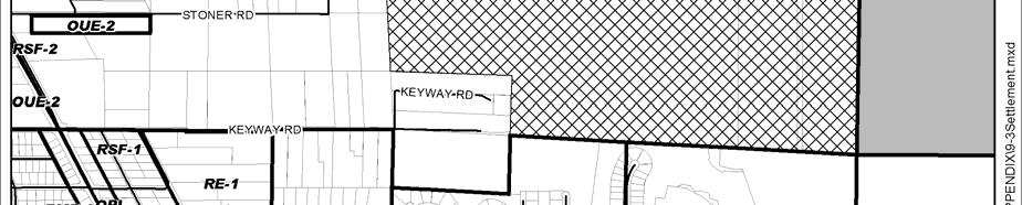

107 Future Land Use Figure 9-3: Settlement Area Overlay Updated: 17-Nov


108 Chapter 9 Figure 9-4: Affordable Housing Overlay Updated: 17-Nov-06


109 Future Land Use Figure 9-5: City of Venice Joint Planning Area Updated: 17-Nov

")
110 Chapter 9 Figure 9-6: Special Planning Area Number 1 (RU-131, Ord No , March 14, 2008) Updated: 17-Nov-06


")
111 Future Land Use Figure 9-7: Special Planning Area 2 Medical Boulevard Development ( G, Ord. No , May 13, 2008) Updated: 17-Nov


 9-112")
112 Chapter 9 Figure 9-8: Special Planning Area 3 ( G, Ord. No , Oct. 27, 2010) Updated: 17-Nov-06
Chapter 10 IMPLEMENTATION RECOMMENDATIONS
 Chapter 10 IMPLEMENTATION RECOMMENDATIONS The recommended land use plan presented in the previous chapter provides a design for the attainment of the urban and rural development and open space preservation
NEW CASTLE COUNTY S ZONING DISTRICTS
 NEW CASTLE COUNTY S ZONING DISTRICTS This is general information about New Castle County s zoning districts. The information included is by no means exhaustive or complete. Before designing plans to develop
CHAPTER 4 FUTURE LAND USE AND URBAN SERVICES DISTRICTS
 CHAPTER 4 FUTURE LAND USE AND URBAN SERVICES DISTRICTS Introduction This chapter discusses how Benzie County should grow and change in the future. A community can grow and change in many different ways.
Baumgarten MPUD. Exhibit 3 Evaluation Criteria
 Pursuant to LDC subsections 10.02.13 B, 10.02.08 F and Chapter 3 G. of the Administrative Code, staff s analysis and recommendation to the Planning Commission, and the Planning Commission s recommendation
TABLE OF CONTENTS APPENDIX A PUBLIC WORKSHOP INFORMATION APPENDIX B BUSINESS CENTER TECHNICAL REPORTS APPENDIX C CORRESPONDENCE IN SUPPORT/OPPOSITION
 TABLE OF CONTENTS RCTOD REZONE AMENDMENT DESCRIPTION... 1 MAP SERIES... 2 RESIDENTIAL COMMERCIAL TRANSITION OVERLAY DISTRICT... 7 FINDINGS OF FACT.15 CONCURRENCY SUMMARY REPORT... 16 APPENDIX A PUBLIC
CHARLES PUTMAN CHARLES PUTMAN AND ASSOCIATES, INC
 MEMORANDUM CHARLES PUTMAN & ASSOCIATES, INC. LAND DEVELOPMENT CONSULTANTS PLANNING ZONING PERMITTING 4722 NW Boca Raton Boulevard, Suite C-106 Boca Raton, Florida 33431 Phone: 561/994-6411 FAX: 561/994-0447
Subject: Hendry County Evaluation and Appraisal Report Letter of Understanding - Identification of Major Issues
 HENDRY COUNTY PLANNING & ZONING DEPARTMENT POST OFFICE BOX 2340 165 S. LEE STREET LABELLE, FLORIDA 33975 (863) 675-5240 FAX: (863) 675-5317 SUNCOM 744-4750 November 16, 2007 Mr. Mike McDaniel, Chief Office
Definitions. Average Daily Traffic Demand (ADT): The actual number or projected number of cars that pass a point in a 24-hour period.
: The actual number or projected number of cars that pass a point in a 24-hour period.") Definitions Access Management: A combination of physical techniques and transportation policies used to control the flow of traffic between roads and the surrounding lands. Alternative City Form Scenarios:
Definitions Access Management: A combination of physical techniques and transportation policies used to control the flow of traffic between roads and the surrounding lands. Alternative City Form Scenarios:
LAND USE ELEMENT. Purpose. General Goals & Policies
 LAND USE ELEMENT Purpose This Land Use Element contains the goals and policies necessary to support the City s responsibility for managing land resources and guiding development through implementing regulations,
TREASURE COAST REGIONAL PLANNING COUNCIL M E M O R A N D U M. To: Council Members AGENDA ITEM 5H
 TREASURE COAST REGIONAL PLANNING COUNCIL M E M O R A N D U M To: Council Members AGENDA ITEM 5H From: Date: Subject: Staff October 17, 2008 Council Meeting Local Government Comprehensive Plan Review Draft
AWH REPORT OF THE PLANNING AND DEVELOPMENT DEPARTMENT FOR APPLICATION FOR REZONING ORDINANCE TO PLANNED UNIT DEVELOPMENT
 AWH REPORT OF THE PLANNING AND DEVELOPMENT DEPARTMENT FOR APPLICATION FOR REZONING ORDINANCE TO PLANNED UNIT DEVELOPMENT MAY 8, 2014 The Planning and Development Department hereby forwards to the Planning
Selected Area Study. Vision Plan Draft
 East Polk County Selected Area Study Draft 10.30.08 Contents Guiding Principles...4 Context Conclusions...5 Current Context...8 Scenarios...9 Scenario: Status Quo...10 Scenario: Connected & Directed Growth...12
3.10 LAND USE SETTING PROJECT SITE EXISTING LAND USE DESIGNATIONS AND ZONING. General Plan Land Use Designations.
 This section of the Draft EIR addresses the existing land uses on and adjacent to the project site and discusses the potential impacts of the proposed project on existing land uses. Key issues addressed
COLVER ROAD INDUSTRIAL CONCEPT PLAN
 COLVER ROAD INDUSTRIAL CONCEPT PLAN A CONCEPTUAL LAND USE AND TRANSPORTATION PLAN FOR TA-4 AN URBAN RESERVE AREA OF THE CITY TALENT City of Talent Adopted by City Council Resolution No., June, 2015 PART
Rural Land Use Designations Kittitas County December 6, 2007 Draft
 KITTITAS COUNTY COMMUNITY DEVELOPMENT SERVICES 411 N. Ruby St., Suite 2, Ellensburg, WA 98926 CDS@CO.KITTITAS.WA.US Office (509) 962-7506 Fax (509) 962-7682 Rural Land Use Designations Kittitas County
Mobility Districts and Traffic Studies
 Mobility Districts and Traffic Studies During the last Comprehensive Plan update in 2008, the City of Sarasota identified the need to develop a citywide strategy for enhancing the mobility options of all
City of Palm Coast 2035 Comprehensive Plan - Goals, Objectives, and Policies EXECUTIVE SUMMARY
 EXECUTIVE SUMMARY INTRODUCTION The original Comprehensive Plan, with two adopted planning timeframes, was adopted in 2004, following the City s incorporation in 1999. The first timeframe is five (5) years
Dwelling Units Max 12 dwelling units per acre/min 8 dwelling units per acre. Development Mix 80% non residential/20% residential
 13. OSTEEN LOCAL PLAN Background: The Osteen Local Plan area is located in southwest Volusia County along the SR 415 corridor between Lemon Bluff Road and Acorn Lake Road and includes 3,990 acres. The
A Growing Community Rural Settlement Areas
 Town of Huntsville Official Plan Review - POLICY BACKGROUND PAPER A Growing Community Rural Settlement Areas BACKGROUND: In addition to the fully municipally-serviced Urban Settlement Area and the Hidden
ALBEMARLE COUNTY CODE CHAPTER 18 ZONING SECTION 20A NEIGHBORHOOD MODEL - NMD
 CHAPTER 18 ZONING SECTION 20A NEIGHBORHOOD MODEL - NMD Sections: 20A.1 PURPOSE AND INTENT 20A.2 STATUS AS A PLANNED DEVELOPMENT DISTRICT 20A.5 CODES OF DEVELOPMENT 20A.6 PERMITTED USES 20A.7 RESIDENTIAL
SECTION UNIFIED DEVELOPMENT ORDINANCE SECTION Part 1 Ordinance. ARTICLE 1 Zoning Districts
 SECTION 1-100 UNIFIED DEVELOPMENT ORDINANCE SECTION 1-300 Part 1 Ordinance SECTION 1-100. Introduction. ARTICLE 1 Zoning Districts Crystal Lake strives to maintain a balance of various land uses for a
MEMORANDUM AGENDA ITEM #6c
 South Florida Regional Planning Council MEMORANDUM AGENDA ITEM #6c DATE: FEBRUARY 1, 2010 TO: FROM: SUBJECT: COUNCIL MEMBERS STAFF CITY OF PARKLAND PROPOSED COMPREHENSIVE PLAN AMENDMENT (ALTERNATIVE REVIEW)
IMPLEMENTATION STRATEGIES. In This Chapter. Goals & Strategies 182 Project List 183 Future Land Use 186 CHAPTER 11 IMPLEMENTATION STRATEGIES
 In This Chapter Goals & Strategies 182 Project List 183 Future Land Use 186 11 IMPLEMENTATION STRATEGIES NORTH AUGUSTA, SC 2017 COMPREHENSIVE PLAN 179 Individual commitment to a group effort that is what
TRANSPORTATION ELEMENT GOALS, OBJECTIVES, AND POLICIES
 TRANSPORTATION ELEMENT GOALS, OBJECTIVES, AND POLICIES GOAL 2 The City shall provide a safe, convenient, effective, and energy efficient multimodal transportation system which is coordinated with the Future
TREASURE COAST REGIONAL PLANNING COUNCIL M E M O R A N D U M. To: Council Members AGENDA ITEM 5I
 TREASURE COAST REGIONAL PLANNING COUNCIL M E M O R A N D U M To: Council Members AGENDA ITEM 5I From: Date: Subject: Staff December 12, 2008 Council Meeting Local Government Comprehensive Plan Review Town
Mitchell Ranch South MPUD Application for Master Planned Unit Development Approval Project Narrative. Introduction
 Mitchell Ranch South MPUD Application for Master Planned Unit Development Approval Project Narrative Introduction Mitchell Ranch South is a proposed single family (detached) residential development on
ROAD CLOSURE AND LAND USE AMENDMENT SILVER SPRINGS (WARD 1) NORTHEAST OF NOSEHILL DRIVE NW AND SILVER SPRINGS ROAD NW BYLAWS 2C2018 AND 29D2018
 NORTHEAST OF NOSEHILL DRIVE NW AND SILVER SPRINGS ROAD NW BYLAWS 2C2018 AND 29D2018") Page 1 of 19 EXECUTIVE SUMMARY This application proposes redesignating two parcels in the community of Silver Springs from Special Purpose Future Urban Development (S-FUD) District and undesignated road
Page 1 of 19 EXECUTIVE SUMMARY This application proposes redesignating two parcels in the community of Silver Springs from Special Purpose Future Urban Development (S-FUD) District and undesignated road
Woodburn Comprehensive Plan Growth Management Goals and Policies
 Goal Woodburn Comprehensive Plan Growth Management Goals and Policies G-1. The City's goal is to manage growth in a balanced, orderly and efficient manner, consistent with the City s coordinated population
2.0 AREA PLANS. Lakeside Business District. Lakeside Business District Land Use Categories:
 Lakeside Business District Lakeside Business District Land Use Categories: Campus Commercial Campus Commercial means a mixture of uses which includes corporate offices, office parks, hotels, commercial,
CHAPTER 7: VISION AND ACTION STATEMENTS. Noble 2025 Vision Statement
 CHAPTER 7: VISION AND ACTION STATEMENTS This chapter presents the vision, policy and action statements that transform the comprehensive planning study, an analysis of Noble s past, future trends and community
7,600 Residential Units 1,700,000 SF Non-Res 300-Room ALF 300-Room Hotel University School, Park, Civic parcels 1,889 ac flow-way/preservation
 4,763 ac undeveloped long-term AG use Over 75% characterized by non-native & invasive species Has severely degraded habitat functions 11,565 of frontage along Northlake Blvd. 1,687 of frontage along Beeline
open public hearing and allow public comment request to continue LPA public hearing to January 16, 2014 at 10:30 am
 TODAY S AGENDA Work Session LPA Transmittal Public Hearing open public hearing and allow public comment request to continue LPA public hearing to January 16, 2014 at 10:30 am staff will issue a recommendation
Hockessin Community Redevelopment Plan
 Hockessin Community Redevelopment Plan 3.1 Introduction The Community Redevelopment Plan for the Village of Hockessin is the result of the people s vision for a distinct village center that serves as the
Ten Mile Creek Planning Area
 PLANNING AREA POLICIES TEN MILE CREEK Ten Mile Creek Planning Area Location and Context The Ten Mile Creek Planning Area ( Ten Mile Creek area ) is located south of the current Boise AOCI, generally south
Plan Modification to Chapter B2 of the Auckland Unitary Plan(AUP) Operative in part (15 November 2016)
 Operative in part (15 November 2016)") UNITARY PLAN UPDATE REQUEST MEMORANDUM TO FROM Phill Reid Linley Wilkinson DATE 25 September 2018 SUBJECT Plan Modification to Chapter B2 of the Auckland Unitary Plan(AUP) Operative in part (15 November
UNITARY PLAN UPDATE REQUEST MEMORANDUM TO FROM Phill Reid Linley Wilkinson DATE 25 September 2018 SUBJECT Plan Modification to Chapter B2 of the Auckland Unitary Plan(AUP) Operative in part (15 November
The transportation system in a community is an
 7 TRANSPORTATION The transportation system in a community is an important factor contributing to the quality of life of the residents. Without a sound transportation system to bring both goods and patrons
TRANSIT SUPPORTIVE DEVELOPMENT ANALYSIS
 7 TRANSIT SUPPORTIVE DEVELOPMENT ANALYSIS One of the key comments heard over and over through the public involvement process was that the region needs a more robust transit system to provide a viable alternative
Tāhuhu whakaruruhau ā-taone The sheltering ridge pole
 B2. Tāhuhu whakaruruhau ā-taone - Urban growth and form B2.1. Issues Tāhuhu whakaruruhau ā-taone The sheltering ridge pole Auckland s growing population increases demand for housing, employment, business,
Proposed Comprehensive Plan Strategies DRAFT for discussion June 28, 2017
 Proposed Comprehensive Plan Strategies DRAFT for discussion June 28, 2017 Land Use Rural Areas Refine the Farm and Forest area (FF) Update FF boundaries to account for existing lots less than five acres
2025 COMPREHENSIVE PLAN PASCO COUNTY, FLORIDA
 GOAL FLU 6: PASADENA HILLS FUTURE LAND USE: PASADENA HILLS AREA PLAN GOALS, OBJECTIVES, AND POLICIES PASADENA HILLS AREA PLAN: OVERVIEW The Pasadena Hills Area Plan Goals, Objectives, and Policies are
A. WHAT IS A GENERAL PLAN?
 I. Introduction A. WHAT IS A GENERAL PLAN? A general plan is the planning guideline for the future of a city. It contains goals and policies which regulate urban development, the protection of the natural
RECREATION AND OPEN SPACE ELEMENT GOALS, OBJECTIVES, AND POLICIES
 RECREATION AND OPEN SPACE ELEMENT GOALS, OBJECTIVES, AND POLICIES Goal 7 To provide park facilities, recreation programs, and open space resources that are safe, adequate, and accessible to all City residents,
FUTURE LAND USE ELEMENT
 FUTURE LAND USE ELEMENT GOAL I: To create and sustain a great place to live, play, and prosper Objective 1: The City of Ocala shall incorporate the principles and strategies of the Ocala 2035 Vision into
SUSSEX COUNTY COMPREHENSIVE PLAN COUNTY PLANNING AND ZONING COMMISSION WORKSHOP
 SUSSEX COUNTY COMPREHENSIVE PLAN COUNTY PLANNING AND ZONING COMMISSION WORKSHOP August 21, 2017 TODAY S WORKSHOP Public Comment Utilities Update Economic Development Update Future Land Use Discussion Public
Appendix C: Interim Mixed-Use Evaluation Criteria
 Appendix C: Interim Mixed-Use Evaluation Criteria C-1 Appendix C: Interim Mixed-Use Evaluation Criteria PURPOSE: The implementation of numerous policies contained within the Master Plan hinges on the creation
12 January 12, 2011 Public Hearing APPLICANT: TAILWIND DEVELOPMENT GROUP,LLC PROPERTY OWNER: CITY OF VIRGINIA BEACH
 12 January 12, 2011 Public Hearing APPLICANT: TAILWIND DEVELOPMENT GROUP,LLC PROPERTY OWNER: CITY OF VIRGINIA BEACH STAFF PLANNER: Faith Christie REQUEST: Conditional Change of Zoning (from PD-H1 Planned
ARTICLE 6: Special and Planned Development Districts
 ARTICLE 6: Special and Planned Development Districts 6-10 Traditional Neighborhood Development (TND) District 6-10.10 Purpose and Intent The Traditional Neighborhood Development (TND) District provides
2025 COMPREHENSIVE PLAN PASCO COUNTY, FLORIDA
 GOAL FLU 6: PASADENA HILLS FUTURE LAND USE: PASADENA HILLS AREA PLAN GOALS, OBJECTIVES, AND POLICIES PASADENA HILLS AREA PLAN: OVERVIEW The Pasadena Hills Area Plan Goals, Objectives, and Policies are
INTRODUCTION PLANNING HISTORY
 INTRODUCTION The Upper Rock Creek Master Plan Area lies in the east central part of Montgomery County. The Master Plan Area is adjacent to the City of Rockville to the south, the Olney Planning Area to
Future Land Use and Transportation
 Planning & Zoning Board Workshop Comprehensive Plan for Village of Estero Future Land Use and Transportation April 6, 2017 January Kick-off Meeting Public Input What do you like about Estero? Location
6 PORT SYDNEY SETTLEMENT AREA
 Section 6 Port Sydney Page 61 6 PORT SYDNEY SETTLEMENT AREA 6.1 Basis and Principles Village of Port Sydney Waterfront Community Existing Services 6.1.1 Port Sydney is an historic settlement that has developed
Planning & Zoning Commission Staff Report
 Planning & Zoning Commission Staff Report Meeting Date: May 26, 2015 Drafted by: Katherine Harrison-Rogers CASE # Z2886 PROJECT NAME: APPLICANT/ REPRESENTATIVE: Shawna Runyan PROPERTY OWNER: 1840 (previously
WATERFORD Plan of Preservation, Conservation and Development Supplement Part 1 - Policy Element
 WATERFORD 2012 Plan of Preservation, Conservation and Development 2015 Supplement Part 1 - Policy Element Effective June 11, 2015 2015 Plan Update GOAL To respond to the evolving land use needs and continually
PALMER RANCH FUTURE THOROUGHFARE AMENDMENT Sarasota County, Florida. Comprehensive Plan Amendment CPA 2017-A, GA, ES
 PALMER RANCH FUTURE THOROUGHFARE AMENDMENT Sarasota County, Florida Comprehensive Plan Amendment Prepared for: Palmer Ranch Holdings LTD 6571 Palmer Park Circle Sarasota, Florida 34238 Prepared by: Stantec
Implementation Guide Comprehensive Plan City of Allen
 Implementation Guide 2030 Comprehensive Plan City of Allen DRAFT 2015 Implementation Guide Allen 2030 Comprehensive Plan INTRODUCTION The Comprehensive Plan serves as a guide for the growth and development
Executive Summary. NY 7 / NY 2 Corridor
 Executive Summary NY 7 / NY 2 Corridor Transportation and Land Use Study December 2005 Prepared for: Town of Colonie Capital District Transportation Committee Prepared by: Introduction: Land use decisions
LAND USE AMENDMENT CORNERSTONE (WARD 3) 60 STREET NE AND COUNTRY HILLS BOULEVARD NE MAP 26NE BYLAW 22D2017
 60 STREET NE AND COUNTRY HILLS BOULEVARD NE MAP 26NE BYLAW 22D2017") Page 1 of 14 EXECUTIVE SUMMARY This Land Use Amendment application covers an area of 43.76 hectares ± (108.14 acres ±) located in northeast Calgary, bound by Country Hills Boulevard NE to the south and
Page 1 of 14 EXECUTIVE SUMMARY This Land Use Amendment application covers an area of 43.76 hectares ± (108.14 acres ±) located in northeast Calgary, bound by Country Hills Boulevard NE to the south and
Today Land & People. Northeast Nampa Gateway District. Employment. Land Use Characteristics. Demographics. Current Zoning
 Today Land & People Employment Major employers include Saint Alphonsus, the College of Western Idaho, the Auto Mall, Sorrento Lactalis and Walmart. 3,004 jobs in 2010 (COMPASS-CIM 2040 TAZ data) 4,345
PSRC REVIEW REPORT & CERTIFICATION RECOMMENDATION
 PSRC REVIEW REPORT & CERTIFICATION RECOMMENDATION KITSAP COUNTY COUNTYWIDE PLANNING POLICIES July 2, 2012 BACKGROUND A major emphasis of the Washington State Growth Management Act (GMA) is the need to
Gold Line Bus Rapid Transit Transit Oriented Development (BRTOD) Helmo Station Area Plan
 Helmo Station Area Plan") Appendix F Gold Line Bus Rapid Transit Transit Oriented Development (BRTOD) Helmo Station Area Plan Introduction and Purpose of the Plan The Gold Line Bus Rapid Transit facility is an eleven-mile dedicated
Appendix F Gold Line Bus Rapid Transit Transit Oriented Development (BRTOD) Helmo Station Area Plan Introduction and Purpose of the Plan The Gold Line Bus Rapid Transit facility is an eleven-mile dedicated
PORT WHITBY COMMUNITY
 PORT WHITBY COMMUNITY SECONDARY PLAN UPDATE COMMUNITY IMPROVEMENT PLAN URBAN DESIGN GUIDELINES September 2015 DRAFT PROPOSED AMENDMENT NUMBER # to the Whitby Official Plan PURPOSE: The intent of this Amendment
EXECUTIVE SUMMARY DRAFT CHAPTER 1 INTRODUCTION EXECUTIVE SUMMARY
 CHAPTER 1 EXECUTIVE SUMMARY INTRODUCTION Through the joint efforts of the City of Tulsa planning staff and the Land Services division of Indian Nations Council of Governments (INCOG), the Berryhill Land
DISCUSSION ON VACAVILLE S2 INVESTORS PROPERTY IN URBAN RESERVE
 Agenda Item No. 9C April 25, 2017 TO: FROM: SUBJECT: Honorable Mayor and City Council Attention: Jeremy Craig, Interim City Manager Barton Brierley, AICP, Community Development Director (Staff Contact:
Regional Context Statement
 Regional Context Statement REGIONAL CONTEXT STATEMENT 3. REGIONAL CONTEXT STATEMENT In 1995, the Provincial Government passed into law the Growth Strategies Act. The purpose of this provincial initiative
Micco Park Village Development
 FOR SALE Call For Pricing Micco Park Village Development Proposed Project Property Details Micco Park Village Development PRICE Call For Pricing A monumental development opportunity of a lifetime! The
Staff Report and Recommendation
 Community Planning and Development Planning Services 201 W. Colfax Ave., Dept. 205 Denver, CO 80202 p: 720.865.2915 f: 720.865.3052 www.denvergov.org/cpd TO: City Council Neighborhoods and Planning Committee
CHAPTER 12 IMPLEMENTATION
 CHAPTER 12 IMPLEMENTATION The 2010 Town of Denton Comprehensive Plan is intended to capture a vision of the future of Denton. As such, it provides a basis for a wide variety of public and private actions
Urban Development Areas Frederick County
 18 Urban Development Areas Frederick County UDA Needs Profile: All UDAs Frederick County, Virginia's northernmost county has two UDA s, surrounded by the City of Winchester and located adjacent to the
CITY OF TARPON SPRINGS DCA#11-1AR
 Agenda Item #3.H.2 05/09/11 TAMPA BAY REGIONAL PLANNING COUNCIL LOCAL GOVERNMENT COMPREHENSIVE PLAN ADOPTED AMENDMENT REPORT CITY OF TARPON SPRINGS DCA#11-1AR 1 ADOPTED WITH THE FOLLOWING CHANGES: Ordinance
CITY OF TIGARD EXPECTED SERVICE AREA
 CITY OF TIGARD EXPECTED SERVICE AREA City overview / Background Incorporated in 1961, the has experienced rapid growth over the years. This growth can be attributed to many factors, primarily the close
Intergovermental Coordination
 Intergovermental Coordination CITY OF WINTER PARK CHAPTER 8: INTERGOVERNMENTAL COORDINATION ELEMENT INTERGOVERNMENTAL COORDINATION ELEMENT GOAL 8-1: PROVIDE FOR IMPROVED INTERGOVERNMENTAL COORDINATION
General Location Annex, Rezone & Preliminary Plat Lansdowne Addition, Unit Three
 NEWFOUNDLAND I-5 Agricultural District Subject Site SUNDANCE ANDERSON Single Family Residential CHRISTY PUD Agricultural District Highway Business General Location Annex, Rezone & Preliminary Plat Lansdowne
MIXED-USE VILLAGE OVERLAY FLOATING DISTRICT
 MIXED-USE VILLAGE OVERLAY FLOATING DISTRICT Zoning regulations developed by committee to the Planning Board for the Town of DeWitt, NY Issue date: 13 July 2017 revised 3/12/2018, revised 4/26/2018, 5/9/2018
Former Rockcliffe Airbase Community Design Plan Guiding Design Vision and Principles December 4, 2013
 APPENDIX 5 - Guiding Design Vision and Principles Former Rockcliffe Airbase Community Design Plan Guiding Design Vision and Principles December 4, 2013 Vision Statement The redevelopment of the former
Land Use Amendment in Southwood (Ward 11) at and Elbow Drive SW, LOC
 at and Elbow Drive SW, LOC") 2018 November 15 Page 1 of 10 EXECUTIVE SUMMARY This land use amendment application was submitted by Rick Balbi Architect on 2017 August 31 on behalf of Sable Developments Ltd, and with authorization from
2018 November 15 Page 1 of 10 EXECUTIVE SUMMARY This land use amendment application was submitted by Rick Balbi Architect on 2017 August 31 on behalf of Sable Developments Ltd, and with authorization from
LAND USE MEADOWS PLANNING AREA
 LAND USE MEADOWS PLANNING AREA I. Profile of Meadows Planning Area A. Location Meadows Planning Area is delineated by I-5 on the north, the Nisqually Bluffs representing the growth boundary on the east,
Gloucester County s Comprehensive Plan. The Community Connection
 Gloucester County s Comprehensive Plan The Community Connection Current Comp Plan Adopted in 1991 with a 20 year planning horizon Updated in 1995 with Part V- Implementation Recommendations and Appendix
1934 Commerce Lane Suite 1 Jupiter, Florida Ph Fax Lic # LC-C ATTACHMENT G.
 Landscape Architects I Land Planners I Environmental Consultants 1934 Commerce Lane Suite 1 Jupiter, Florida 33458 Ph 561.747.6336 Fax 561.747.1377 www.cotleurhearing.com Lic # LC-C000239 ATTACHMENT G
4.1.3 LAND USE CATEGORIES
 4.1.3 LAND USE CATEGORIES a. City Center District The City Center District incorporates the existing character and mix of uses in downtown Belmont to encourage redevelopment and new development in keeping
City Center Neighborhood Plan
 [1] City Center Neighborhood Plan As adopted by Ordinance No. 2014-09-049 and amended by Ordinance Nos. Formerly CBD Neighborhood as adopted by Ordinance No. 8868 and amended by Ordinance Nos. 8946, 9693,
LAND USE GOALS, OBJECTIVES AND POLICIES. Goal 1: [L] (EFF. 7/16/90)
![LAND USE GOALS, OBJECTIVES AND POLICIES. Goal 1: [L] (EFF. 7/16/90)](/thumbs/88/115018937.jpg "LAND USE GOALS, OBJECTIVES AND POLICIES. Goal 1: [L] (EFF. 7/16/90)") LAND USE GOALS, OBJECTIVES AND POLICIES Goal 1: [L] (EFF. 7/16/90) The Comprehensive Plan shall protect and enhance the quality of life in this community by providing economically sound educational, employment,
LAND USE GOALS, OBJECTIVES AND POLICIES Goal 1: [L] (EFF. 7/16/90) The Comprehensive Plan shall protect and enhance the quality of life in this community by providing economically sound educational, employment,
Chapter 6: Community Character
 Chapter 6: Community Character The term "community character" covers a broad spectrum of concerns. First and foremost, community character is a visual concept. In Long Grove, however, community character
Comprehensive Plan ADOPTED APRIL 2014
 Comprehensive Plan ADOPTED APRIL 2014 8 8. Outstanding Recreational & Cultural Opportunities We are proud of our community s parks and recreation system. Our community will ensure that the legacy of our
This chapter describes the purpose of the Plan, introduces how the Plan is organized and provides contextual background for the Plan.
 Chapter 1: INTRODUCTION Purpose of a Comprehensive Plan The 2040 Comprehensive Plan establishes Medina s vision as a community and sets goals and objectives which guide future decisions and policies. The
Subject: City of Richfield Cedar Avenue Corridor Plan Comprehensive Plan Amendment, Review File No
 Committee Report Business Item No. 2017-21 Community Development Committee For the Metropolitan Council meeting of January 25, 2017 Subject: City of Richfield Cedar Avenue Corridor Plan Comprehensive Plan
Living in Albemarle County s Urban Places
 Living in Albemarle County s Urban Places ALBEMARLE COUNTY, VIRGINIA A Closer Look at Albemarle s Approach to Managing Growth and Creating Quality Urban Environments www.albemarle.org Page 2 Living in
E. RURAL COMMERCIAL/INDUSTRIAL PARK MODEL
 E. RURAL COMMERCIAL/INDUSTRIAL PARK MODEL 1. PURPOSE The purpose of the Rural Commerce/Industrial Park Model is to provide parameters within which a grouping of business buildings with parking, loading
Secrest Short Cut and Monroe Expressway Small Area Plan AUGUST 29, 2018
 Secrest Short Cut and Monroe Expressway Small Area Plan AUGUST 29, 2018 Background and Process Monroe Expressway will be open by the end of 2018 Union County and Indian Trail identified a need to revisit
LAND USE OVERVIEW WHAT YOU WILL FIND IN THIS CHAPTER
 LAND USE WHAT YOU WILL FIND IN THIS CHAPTER Information about the City s expected population and employment growth. Description and capacity of existing and future land use designations. Policies that
Official Plan Review
 Official Plan Review Summary Report - The Built Environment August 2014 Part 1: Introduction Planning for a healthy, prosperous and sustainable community is an important goal for our municipality. From
INTRODUCTION. b. The extent to which such problems and objectives have been reduced or have increased subsequent to such date.
 INTRODUCTION INTRODUCTION The Municipal Land Use Law directs a Planning Board to prepare a Periodic Reexamination Report every six years that identifies and describes the following: a. The major problems
LAND USE DESIGNATIONS AND ZONING CLASSIFICATIONS
 LAND USE DESIGNATIONS AND ZONING CLASSIFICATIONS One of the most significant issues addressed within the community plan process is land use. How land is utilized within a community directly affects the
[THIS PAGE INTENTIONALLY LEFT BLANK]
![[THIS PAGE INTENTIONALLY LEFT BLANK]](/thumbs/77/76526040.jpg "[THIS PAGE INTENTIONALLY LEFT BLANK]") 1-1 LAND USE [THIS PAGE INTENTIONALLY LEFT BLANK] TABLE OF CONTENTS INTRODUCTION... 7 1-1. GOAL: TO DEVELOP AND MAINTAIN A WELL-BALANCED COMMUNITY WITH A VARIETY OF LAND USES THAT ARE COMPATIBLE WITH EACH
1-1 LAND USE [THIS PAGE INTENTIONALLY LEFT BLANK] TABLE OF CONTENTS INTRODUCTION... 7 1-1. GOAL: TO DEVELOP AND MAINTAIN A WELL-BALANCED COMMUNITY WITH A VARIETY OF LAND USES THAT ARE COMPATIBLE WITH EACH
VILLAGE OF CLEMMONS PLANNING BOARD DRAFT STAFF REPORT
 VILLAGE OF CLEMMONS PLANNING BOARD DRAFT STAFF REPORT PETITION INFORMATION Docket # C-226 Staff Megan Ledbetter Petitioner(s) JBJH Properties, LLC Owner(s) JBJH Properties, LLC Subject Property 5892-49-1766
ORDINANCE WHEREAS, this Ordinance is consistent with the City of Winter Garden Comprehensive Plan; and
 ORDINANCE 17-06 AN ORDINANCE OF THE CITY COMMISSION OF THE CITY OF WINTER GARDEN, FLORIDA, CREATING ARTICLE XIV OF CHAPTER 118 OF THE CITY OF WINTER GARDEN CODE OF ORDINANCES PROVIDING FOR THE EAST PLANT
CITY OF COLWICH COMPREHENSIVE PLAN LAND USE LAND USE 1
 LAND USE LAND USE 1 WHAT YOU WILL FIND IN THIS CHAPTER: Discussion of today s conditions and tomorrow s projections Discussion of challenges and opportunities Discussion of the environmental quality goals,
Urban Development Areas Bedford County
 5 Urban Development Areas Bedford County UDA Needs Profile: All UDAs Bedford County has designated two UDAs: areas just outside the Bedford City Limits (generally to the south and east of the city) and
Clackamas County Comprehensive Plan. Chapter 4: LAND USE
 Chapter 4: LAND USE When the pioneers settled Clackamas County, the land resource appeared infinite. They cleared forest, carved towns from the wilderness, and used waterways as the arterials of commerce.
6 Growth Management Challenges and Opportunities
 6 Growth Management Challenges and Opportunities The Town has established a goal of attaining a 50% participation rate with respect to employment opportunities versus residential population. The Town s
SUBJECT: LOCAL GOVERNMENT COMPREHENSIVE PLAN PROPOSED AND ADOPTED AMENDMENT CONSENT AGENDA
 MEMORANDUM AGENDA ITEM #IV.C DATE: APRIL 15, 2019 TO: FROM: COUNCIL MEMBERS STAFF SUBJECT: LOCAL GOVERNMENT COMPREHENSIVE PLAN PROPOSED AND ADOPTED AMENDMENT CONSENT AGENDA Pursuant to the 1974 Interlocal