Zoning Rewrite Implementation Worksession #4. Commercial Zones April 17, 2013
|
|
|
- Malcolm Cameron
- 5 years ago
- Views:
Transcription
1 Zoning Rewrite Implementation Worksession #4 Commercial Zones April 17,


2 This is Change You never change things by fighting the existing reality. To change something, build a new model that makes the existing model obsolete. R. Buckminster Fuller 2

3 But not Fast or Dramatic Nothing is so painful to the human mind as a great and sudden change. Mary Shelley The castle was approved as a special exception and, the application should have been pronounced Frankensteen!!!!!!!! Lesson learned: nothing in MoCo happens suddenly. 3


4 benefits Back to the Future From The Big Picture, September 2012 neighborhood retail Who is development serving? What is the focus of uses? hearing permit What are the impacts? What are the trade-offs? employment region basics 4


5 Back to the Future Sprawl potential: 4% greenfield available Zoning Discovery 2009 Match land use to development patterns Accommodate change and recognize consistency Sustainable Goals: Do not rely on greenfields Do not put pressure on existing residential neighborhoods Transform single-use commercial into mixed use 5


6 Back to the Future Approach & Annotated Outline 2010 New set of zones Reorganization of regulations based on context Framework: Infill Mixed use **New Goal: Regulations should match impacts Modified by: Zone Use Building type (Adjacent land use) 6


7 Sustainability Audit by Farr Associates Buildings & Neighborhoods Stormwater Parking Tree Canopy & Heat Island Water Reuse & Irrigation Energy Food Production Lighting Waste Reduction Dockside Green is slated to be North America's first carbon-neutral community. (2,500 people in Victoria, BC) 7
8 Sustainability Audit Buildings & Neighborhoods Stormwater Parking Tree Canopy & Heat Island Water Reuse & Irrigation Energy Food Production Lighting Waste Reduction Buildings and Neighborhoods sustaining appropriate densities improving walkability expanding housing diversity Stormwater treating stormwater effectively in urban conditions ensuring that regulation of less dense areas allows for treatment above state mandates Parking right-sizing parking requirements reducing the parking footprint Tree Canopy & Heat Island encouraging more tree canopy reducing imperviousness mitigating the heat island effect 8
9 Sustainability Audit Buildings & Neighborhoods Stormwater Parking Tree Canopy & Heat Island Water Reuse & Irrigation Energy Food Production Lighting Waste Reduction Water Reuse & Irrigation accommodating water reuse decreasing the need for irrigation Energy promoting district energy encouraging renewable energy source facilities Food Production increasing access to local food promoting gardens allowing sale of local food Lighting decreasing light pollution reducing light spill-over Waste Reduction dealing with construction waste 9

10 Green Paper: Land Use Districts and Focused Integration Consolidation of Zones Concept, April 2009 Current Zones Proposed Use Districts Symbol RDT, Rural, RC, RS, RE-2, Country Inn, RNC, LDRC Agricultural A RE-1, R-150, R-200, RMH-200 Residential Low Density RLD R-90, RMH, R-60, R-40, RT-6, RT-8, R-4Plex Residential Medium Density RMD RT-10, RT-12.5, RT-15, R-30, R-20 Residential High Density RHD R-10, R-H, RMX-1/2/2C/3/3C, MXTC, CBD-R-1, TOMX, CBD-R2, TMX, TSR C-5, C-6, C-T, C-1, C-2, C-3, C-4, CBD-0.5/1/2/3, H-M, C-O, TS-M Commercial/Residential (typically higher residential density than commercial) Commercial/Residential (typically higher commercial density than residential) RC CR C-P, I-3, R&D, LSC, O-M Mixed Campus MC I-1, I-4 Industrial, Light IL I-2, MRR Industrial, Heavy IH New Zone? Industrial, Service IS 10
11 Rationale: Population & Demographics Since the Zoning Discovery in 2009, the population has increased by more than 70,000 people. Choices: Agricultural Reserve 4% greenfields Existing residential neighborhoods Mixed use zones & transit Zoning Ordinance Subdivision Regulations Master Plans 11

12 Rationale: Population & Demographics Forecast: The number of residents over 65 years of age will increase by 81%; The number of dual-parent households will decrease; Households will get smaller; and Households with children will decrease. Source: National Housing Conference 12

13 Rationale: Population & Demographics Issues: Aging in place Services Communities Young professionals? First time homowners? 13
 Height Open Space")
14 Commercial Zones Basic C-T, transitional commercial C-1, convenience commercial C-2, general commercial C-3, highway commercial C-4, limited commercial Office/Other O-M, moderate intensity office C-O, commercial office C-P, commercial office park H-M, hotel-motel C-Inn, country inn Decisions/effects Zoning classification Uses Service intent Density Mix (if applicable) Height Open Space Setbacks Process are you being served? 14


15 Available Zoning Classifications CR, commercial residential CRN, com/res neighborhood CRT, com/res town NR, neighborhood retail GR, general retail EOF, employment office Intents: C/R CRN: pedestrian-scale, neighborhoodserving mixed use centers & transitional edges CRT: small downtown, mixed-use, pedestrian-oriented centers & edges of larger downtowns CR: larger downtown, mixed-use, pedestrian-oriented, with transit options 15

16 Available Zoning Classifications CR, commercial residential CRN, com/res neighborhood CRT, com/res town NR, neighborhood retail GR, general retail EOF, employment office Intents: Employment GR: general commercial, regional shopping centers, commercial clusters, auto-dominated corridors with few transit options NR: convenient access to neighborhood necessities; adjacent to residential areas without mobility options/ critical mass EOF: office and employment activity, limited residential and other commercial uses 16
 C-1 C-2 (if not permitted) C-3 C-4 (if not permitted) C-6 Implications of adding residential Allowed density Rationalized to 0.")
17 Flexibility in Uses Current allowances for residential: Permitted in: C-T (if existing) O-M (if existing) C-O (subject to R-60 standards) C-2 (qualifiers) C-4 (qualifiers) Special exception in: O-M (if not existing) C-1 C-2 (if not permitted) C-3 C-4 (if not permitted) C-6 Implications of adding residential Allowed density Rationalized to 0.25 FAR increments Increases or decreases in total density allowed were avoided based on current development rights Caps on R generally lower than total allowed FAR When residential is permitted, rarely built-out (e.g., CBD - Wheaton, TMX Germantown & Twinbrook, MXTC Damascus & Olney, etc.) Under translation acres (0.004% of County): acres capped at 0-75% residential acres capped at 30% residential If built 1/3 of total allowed density as residential, would accommodate up to 14,000 units (including up to 1,750 MPDUs) or about 2 years of average population growth 17
 C-1 C-2 (if not permitted) C-3 C-4 (if not permitted) C-6 Implications of adding residential Master plan staging Capacity for residential units is capped by most master plans")
18 Flexibility in Uses Current allowances for residential: Permitted in: C-T (if existing) O-M (if existing) C-O (subject to R-60 standards) C-2 (qualifiers) C-4 (qualifiers) Special exception in: O-M (if not existing) C-1 C-2 (if not permitted) C-3 C-4 (if not permitted) C-6 Implications of adding residential Master plan staging Capacity for residential units is capped by most master plans Staging requirements entail transit, public facilities, modal share goals, and other improvements to accommodate growth Public facilities APF tests still apply (school, fire & rescue, intersection congestion) Peak-hour trips for residential uses are less than retail/bank/office uses New opportunity for business owner & employee housing Regulations Forest conservation (& tree variance law) New stormwater management New site plan thresholds CR > 0.5 and CRT > 1.0 FAR require public benefits 18
19 Commercial Zones Commercial - Office - Life Sciences acres (0.33%) acres (0.45%) acres (0.24%) Existing Zoning Ag Reserve Rural Residential Estate Residental Low Density Residential Medium Density Townhouse Multi-Family Mixed-Use Comm/Res - Neighborhood Comm/Res - Town Commercial/Residential Central Business District Commercial Office Life Sciences Light Industrial, Low Inten. Light Industrial Heavy Industrial Planned Development


20 Mapping Commercial Zones C-1 C-2 C-3 C-4 C-6 C-Inn C-T H-M
21 Mapping Commercial-Transitional C-T acres 0.02%

 CRN0.5 C0.5 R0.")
22 C-T Translation Max FAR: 0.5 Max Height: 35 CT Translation: acres (70 parcels) CRN0.5 C0.5 R0.25 H35 (66) CRN0.5 C0.5 R0.25 H25 (4) Original model for CRN Only standard method (no public benefits req d) 22


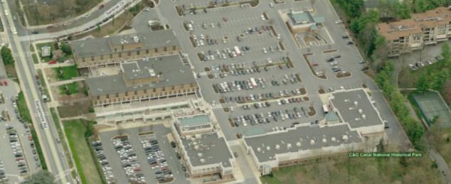
23 Commercial-Transitional (C-T) Examples Our Space Acupuncture
24 C-T Translation Max FAR: 0.5 Max Height: 35 Uses: Permitted Dwellings (if existing) Tourist homes Amateur radio facility Parking Roof top antennas Landscape contractor (qualifiers) Transitory use Ambulance/rescue squad Banks Charitable/philanthropic Day care Clinics (w/pharmacy) Duplicating services Private educational facility Emergency health care Fire stations Offices Religious assembly Public uses Health club (qualifiers) Libraries/museums Parks Accessory buildings/uses Signs 15 additional special exception uses CT to CRN Translation: New Permitted uses Household living (current CRN) Residential care facility ( 8) (current CRN) Live/work units (current CRN) Playground (current CRN) Retail/service ( 5,000sf) (current CRN, 2 retail uses P in CT) Artisan manufacturing/production (current CRN) Railroad tracks (consistency) Pipeline, below ground (consistency) Transmission line, above ground Transmission line, below ground (consistency) 24
25 C-T Translation Uses: Permitted Dwellings (if existing) Tourist homes Amateur radio facility Parking Roof top antennas Landscape contractor (qualifiers) Transitory use Ambulance/rescue squad Banks Charitable/philanthropic Day care Clinics (w/pharmacy) Duplicating services Private educational facility Emergency health care Fire stations Offices Religious assembly Public uses Health club (qualifiers) Libraries/museums Parks Accessory buildings/uses Signs 15 additional special exception uses CT to CRN Translation: New Limited uses Community gardens Urban farming (modified CRN) Animal husbandry (only bees) Farm market, on-site Agricultural vending B&B (Tourist Homes a P) Independent living (current CRN) PLQs ( 50) (current CRN) Home health, low impact (current CRN) Home occupation, no/low impact (current CRN) Residential Care Facility (9-16) (current CRN) Private club (site plan if adj ) (current CRN) Vet (site plan if adj ) (current CRN) 25
26 C-T Translation Uses: Permitted Dwellings (if existing) Tourist homes Amateur radio facility Parking Roof top antennas Landscape contractor (qualifiers) Transitory use Ambulance/rescue squad Banks Charitable/philanthropic Day care Clinics (w/pharmacy) Duplicating services Private educational facility Emergency health care Fire stations Offices Religious assembly Public uses Health club (qualifiers) Libraries/museums Parks Accessory buildings/uses Signs 15 additional special exception uses CT to CRN Translation: Permitted use becoming a Limited use Clinic (> 4) (site plan if adj ) (current CRN) Cultural institution (5,000sf max) (current CRN) Day care (> 30) (site plan if adj ) (current CRN) Private educ. institution (site plan if adj ) (current CRN) Health Club (site plan if adj ) (current CRN) Surface parking (to add landscaping) Special Exception becoming Limited use Residential Care Facility (Over 16) (current CRN) Restaurant (site plan if adj ) (current CRN) Retail (5,001 15,000sf) (site plan if adj ) (current CRN) 26
27 C-T Translation Uses: Permitted Dwellings (if existing) Tourist homes Amateur radio facility Parking Roof top antennas Landscape contractor (qualifiers) Transitory use Ambulance/rescue squad Banks Charitable/philanthropic Day care Clinics (w/pharmacy) Duplicating services Private educational facility Emergency health care Fire stations Offices Religious assembly Public uses Health club (qualifiers) Libraries/museums Parks Accessory buildings/uses Signs 15 additional special exception uses CT to CRN Translation: New Conditional uses PLQs (Over 50) (not allowed in CT, P in CRN) Home Health Practitioner (major) (current CRN) Home Occupation (major) (current CRN) Animal Boarding and Care (current CRN) Recreation & Entertainment, Outdoor (up to 1000) (current CRN) Pipeline, above ground (consistency) Removed uses (not allowed in current CRN) Ambulance or Rescue Squad (private) Telecommunications Tower Funeral Home, Undertaker Structured Parking 27
 SDP/SP Translation: Open Space 10,000sf: 0% > 10,000sf")
28 C-T Translation Max FAR: 0.5 Max Height: 35 Open Space: 10% Coverage: 30-35% Setbacks: Process: (with qualifiers) SDP/SP Translation: Open Space 10,000sf: 0% > 10,000sf 0% for detached/duplex 20% common open space for townhouses 10% public open space for apartment/condo, multi-use, general 28
29 C-T Translation Max FAR: 0.5 Max Height: 35 Open Space: 10% Coverage: 30-35% Setbacks: Process: Y X (with qualifiers) SDP/SP Y X * Translation: Setbacks N/A when abutting C/R, employment, industrial Parking behind front building line Sec Compatibility Development Standards when abutting ag/rur/res If vacant/improved with ag/res use: 1.5 times setback required for detached house in abutting zone If required screening width is greater, setback = screening width Height may also be restricted by angular plane 29
 SDP/SP Subject Property s Zone C/R Proposed Use Permitted Proposed Intensity < 10,000sf and 40 10,000sf or")
30 C-T Translation Translation: Process Max FAR: 0.5 Max Height: 35 Open Space: 10% Coverage: 30-35% Setbacks: Process: (with qualifiers) SDP/SP Subject Property s Zone C/R Proposed Use Permitted Proposed Intensity < 10,000sf and 40 10,000sf or > 40 Abutting/ Confronting Property s Zone Any Ag/Rur/Res All other Site Plan Required Limited Any Any If req d under 59-3; if not follow permitted use threshold No Yes No Sec A.6.c. If a property was subject to an approved development plan or special exception on [date of adoption minus one], the Planning Board in approving any sketch plan, preliminary plan, or site plan must consider the terms and conditions of the approved development plan or special exception. 30
31 Mapping Neighborhood Commercial C acres 0.16%
 Translation varies based on context All translations allow only")
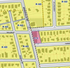
32 C-1 Translation Max FAR: n/a Max Height: 45 Translation: acres (404 parcels) Translation varies based on context All translations allow only standard method CRN NR CRN CRT 32
33 C-1 Translation Max FAR: n/a Max Height: 45 Translation Density Accommodate allowed Factors: Parking environment Open space requirement Service area target Height: comparable to adjacent zones within allowed limits C-1 Translation Acres Parcels Classification C R H Abuts R-150 or lower (auto-centric) NR1.0 H Abuts R-90/60/40 (neighborhood) CRN0.5 C0.5 R0.25 H Confronts R-90/60/40 (town) CRT0.75 C0.5 R0.5 H Otherwise (town) CRT1.0 C0.75 R0.75 H Custom Varies to reflect specific regulations or master plan recommendations


34 Neighborhood Commercial (C-1) Examples Proposed CRT Proposed NR Proposed CRN
 Accessory buildings/uses Signs 22 additional special exception uses C-1 to NR Translation: New Permitted uses")
35 C-1 Translation Uses: Permitted PLQs Amateur radio facility Parking Roof top antennas Taxi stands Various retail/service (28 types) Restaurant Transitory use Ambulance/rescue squad Banks Day care Duplicating services Offices Religious assembly Public uses Health club (qualifiers) Accessory buildings/uses Signs 22 additional special exception uses C-1 to NR Translation: New Permitted uses Seasonal outdoor sales Residential care facility ( 8) Live/work units Private educational institution (trade, artistic, tech schools P in C-1) Playground Clinic ( 4) Bus/rail terminal Railroad tracks Pipeline, below ground Transmission line, below ground 35
36 C-1 to NR Translation: C-1 Translation Uses: Permitted PLQs Amateur radio facility Parking Roof top antennas Taxi stands Various retail/service (28 types) Restaurant Transitory use Ambulance/rescue squad Banks Day care Duplicating services Offices Religious assembly Public uses Health club (qualifiers) Accessory buildings/uses Signs 22 additional special exception uses New Limited uses Community gardens Urban farming Animal husbandry (only bees) Farm market, on site Agricultural vending Independent Living for Seniors Residential care (9-16) Home health practitioner, low impact Home occupation, no/low impact B&B Solar collection system 36
37 C-1 to NR Translation: C-1 Translation Uses: Permitted PLQs Amateur radio facility Parking Roof top antennas Taxi stands Various retail/service (28 types) Restaurant Transitory use Ambulance/rescue squad Banks Day care Duplicating services Offices Religious assembly Public uses Health club (qualifiers) Accessory buildings/uses Signs 22 additional special exception uses New Conditional uses Home Health Practitioner, major Home Occupation, major Special Exception becoming a Limited use Household living (30% of allowed GFA max) Vet (site plan if adj ) Drive-thru (site plan) 37
38 C-1 Translation Uses: Permitted PLQs Amateur radio facility Parking Roof top antennas Taxi stands Various retail/service (28 types) Restaurant Transitory use Ambulance/rescue squad Banks Day care Duplicating services Offices Religious assembly Public uses Health club (qualifiers) Accessory buildings/uses Signs 22 additional special exception uses C-1 to CRN Translation: New Permitted uses Seasonal outdoor sales (current CRN) Residential care facility ( 8) (current CRN) Residential Care Facility (over 16) (current CRN) Live/work units (current CRN) Playground, private (current CRN) Clinic ( 4) Artisan manufacturing/production (current CRN) Railroad tracks (consistency) Pipeline, below ground (current CRN) Transmission line, below ground (current CRN) 38
39 C-1 Translation Uses: Permitted PLQs Amateur radio facility Parking Roof top antennas Taxi stands Various retail/service (28 types) Restaurant Transitory use Ambulance/rescue squad Banks Day care Duplicating services Offices Religious assembly Public uses Health club (qualifiers) Accessory buildings/uses Signs 22 additional special exception uses C-1 to CRN Translation: New Limited uses Community gardens Urban farming (modification of current CRN) Animal husbandry (only bees) Farm market, on-site Agricultural vending Independent living (current CRN) Residential Care facility (9-16) (current CRN) Home health, low impact Home occupation, no/low impact Cultural Institution < 5000 sf (current CRN) Private club (site plan if adj ) (current CRN) B&B Clinic (> 4) (site plan if adj ) (current CRN) Transmission line, above ground New Conditional Uses Home Health Practitioner, major (current CRN) Home Occupation, major (current CRN) 39
40 C-1 Translation Uses: Permitted PLQs Amateur radio facility Parking Roof top antennas Taxi stands Various retail/service (28 types) Restaurant Transitory use Ambulance/rescue squad Banks Day care Duplicating services Offices Religious assembly Public uses Health club (qualifiers) Accessory buildings/uses Signs 22 additional special exception uses C-1 to CRN Translation: Permitted use becoming Limited uses Day care (> 30) (site plan if adj ) (current CRN) Private educational institution (site plan if adj ) (current CRN) Restaurant (site plan if adj ) (current CRN) Health Club Facilities (site plan req replaces size limitation) (current CRN) Special Exception becoming Limited or Permitted use Household Living (current CRN) Charitable/philanthropic (current CRN) Vet (w/ site plan if adj ) (current CRN) Removed Uses (not allowed in current CRN) Drive thru (attached to restaurant) Freestanding Wireless Tower Media Broadcast Tower 40
41 C-1 Translation Uses: Permitted PLQs Amateur radio facility Parking Roof top antennas Taxi stands Various retail/service (28 types) Restaurant Transitory use Ambulance/rescue squad Banks Day care Duplicating services Offices Religious assembly Public uses Health club (qualifiers) Accessory buildings/uses Signs 22 additional special exception uses C-1 to CRT Translation: New Permitted uses Agricultural Vending Seasonal Outdoor Sales (current CRT) Residential Care Facilities (all sizes) (current CRT) Live/Work Units (current CRT) Cultural Institution (current CRT) Hospital (current CRT) Playground, Outdoor Area (private) (current CRT) Private Club, Service Org (current CRT) Hotel/ Motel (current CRT) Clinic (current CRT) Medical/Dental Laboratory (current CRT) Research and Development (current CRT) Conference Center (current CRT) Artisan Manufacturing and Production (current CRT) Railroad Tracks (consistency) Pipeline (Belowground) (consistency) Transmission Line (Belowground) (consistency) 41
42 C-1 Translation Uses: Permitted (46) PLQs Amateur radio facility Parking Roof top antennas Taxi stands Various retail/service (28 types) Restaurant Transitory use Ambulance/rescue squad Banks Day care Duplicating services Offices Religious assembly Public uses Health club (qualifiers) Accessory buildings/uses Signs 22 additional special exception uses C-1 to CRT Translation: New Limited uses Community gardens Urban farming (modified current CRT use) Animal husbandry (only bees) Farm market, on site Independent living (current CRT) Home health practitioner, low impact (current CRT) Home occupation, no/low impact (current CRT) B&B Light vehicle sales/rental (indoor or outdoor) (site plan if adj ) Medical/scientific manufacturing and production (site plan if adj ) (current CRT) Bus/rail terminal (current CRT) Transmission line (above ground) Storage facility (up to 10,000) (current CRT) Solar collection system 42
43 C-1 Translation Uses: Permitted PLQs Amateur radio facility Parking Roof top antennas Taxi stands Various retail/service (28 types) Restaurant Transitory use Ambulance/rescue squad Banks Day care Duplicating services Offices Religious assembly Public uses Health club (qualifiers) Accessory buildings/uses Signs 22 additional special exception uses C-1 to CRT Translation: Permitted becoming Limited Ambulance/rescue squad (site plan if adj ) (current CRT) Day care (> 30) (site plan if adj ) (current CRT) Surface Parking SE becoming Permitted or Limited Household Living (current CRT) Charitable, Philanthropic (current CRT) Vet (site plan if adj ) (current CRT) Rec & Entertainment (Indoor, capacity under 1000) (current CRT) Vehicle service repair (minor) (site plan if adj ) (current CRT) Drive-thru (site plan) (current CRT) Public utility structure (site plan if adj ) 43
44 C-1 Translation Uses: Permitted PLQs Amateur radio facility Parking Roof top antennas Taxi stands Various retail/service (28 types) Restaurant Transitory use Ambulance/rescue squad Banks Day care Duplicating services Offices Religious assembly Public uses Health club (qualifiers) Accessory buildings/uses Signs 22 additional special exception uses C-1 to CRT Translation: New Conditional Uses Home health practitioner (major) (current CRT) Home Occupation (major) (current CRT) Funeral Home, undertaker Car Wash Pipeline (Aboveground) Self-storage (current CRT) Uses Removed from zone Freestanding Telecommunications Tower Media Broadcast Tower (neither allowed in current CRT) 44
45 C-1 Translation Max FAR: n/a Max Height: 45 Open Space: 10% Coverage: Setbacks: Process: n/a 10 /adjoining zone SP (sometimes) Translation: Open Space (C/R & NR) 10,000sf: 0% > 10,000sf 0% for detached/duplex 20% common open space for townhouses 10% public open space for apartment/condo, multi-use, general 45
46 C-1 Translation Max FAR: n/a Max Height: 45 Open Space: 10% Coverage: Setbacks: Process: Y X n/a 10 /adjoining zone SP (sometimes) Y X * Translation: Setbacks in NR & C/R zones N/A when abutting C/R, employment, industrial Parking must accommodate landscaping in NR zones Parking must be behind front building line in C/R zones Sec Compatibility Development Standards when abutting ag/rur/res If vacant/improved with ag/res use: 1.5 times setback required for detached house in abutting zone If required screening width is greater, setback = screening width Height may also be restricted by angular plane 46

47 C-1 Translation Translation: Process for NR & C/R zones Max FAR: n/a Max Height: 45 Open Space: 10% Coverage: Setbacks: Process: n/a 10 /adjoining zone SP (sometimes) Subject Property s Zone Employment Proposed Use Permitted Proposed Intensity < 10,000sf and 40 10,000sf or > 40 Abutting/ Confronting Property s Zone Any Ag/Rur/Res All other Site Plan Required Limited Any Any If req d under 59-3; if not follow permitted use threshold No Yes No 47
Zoning Rewrite Implementation Worksession #3. Industrial Zones April 11, 2013
 Zoning Rewrite Implementation Worksession #3 Industrial Zones April 11, 2013 1 Industrial Zones Current I-1 942.19 acres 0.33% Current I-2 757.36 acres 0.27% Current I-3 (floating) 970.29 acres 0.34% Current
I. Introduction. Prior Approvals
 Statement of Justification First National Bank 19790 Crystal Rock Drive, Germantown, Maryland Application for Site Plan and Limited Preliminary Plan Amendment I. Introduction DPH Architecture, for First
Zoning Interface: Districts and Forms for Sioux Falls Zoning Ordinance
 Zoning Interface: Districts and Forms for Sioux Falls Zoning Ordinance For more information about each form, click on the associated link. Single-Family Residential Districts RR Rural Residential RS Single-Family
RESIDENTIAL DISTRICTS
 RESIDENTIAL DISTRICTS The residential district standards have been revised to reflect on-the-ground conditions, while continuing to respect the use patterns established within the neighborhoods. This will
Rock Spring Master Plan Community Meeting #6: Land Use + Transportation Forecasts
 Rock Spring Master Plan Community Meeting #6: Land Use + Transportation Forecasts May 23, 2016 Ι Walter Johnson High School Andrea Gilles, andrea.gilles@montgomeryplanning.org Ι www.montgomeryplanning.org/community/rockspring/
ASPEN HILL Minor Master Plan Amendment
 ASPEN HILL Minor Master Plan Amendment Project Briefing Planning Board Agenda Item #7 Andrea Gilles, Area 2 June 5, 2014 Briefing Purpose 1. Follow-up evaluation on Mixed-Use land use in the Minor Amendment
ARTICLE GENERAL DEVELOPMENT REGULATIONS DIV SITE ACCESS
 ARTICLE 59-7. GENERAL DEVELOPMENT REGULATIONS DIV. 7.1. SITE ACCESS DIV. 7.4. RECREATION FACILITIES SEC. 7.1.1. INTENT...7 3 SEC. 7.4.1. INTENT...7 25 SEC. 7.1.2. APPLICABILITY...7 3 SEC. 7.4.2. APPLICABILITY...7
The Development Review Process. Presentation to the GSSC IAC
 The Development Review Process Presentation to the GSSC IAC July 19, 2011 Regulatory Processes in the Planning Department Natural Resource Inventory/Forest Stand Delineation Zoning (Development Plan) Special
To ensure that resources will be available to provide a consistent level of public services to the community.
 Future Land Use Plan The land use plan is one of the most prominent chapters in the Stillwater Comprehensive Plan. It provides a visual representation of what the community is expected to look like in
Zoning Technical Review Presented by Camiros. November 10, 2015
 Zoning Technical Review Presented by Camiros November 10, 2015 TECHNICAL REVIEW OVERVIEW Purpose of this Report Outline issues with current Ordinance Present preliminary approaches for revisions Set drafting
CHAPTER 4 - LAND USE CLASSIFICATIONS
 CHAPTER 4 - LAND USE CLASSIFICATIONS Four new land use classification categories are established in the Gualala Town Plan: Gualala Village Mixed Use; Gualala Highway Mixed Use; Gualala Planned Development
, C-MS I June 3, 2016 $1500 pd chk #216918
 , C-MS-8 LOTS 21 THROUGH 40, INCLUSIVE, BLOCK 299 CLEMENTS ADDITION TO THE CITY OF DENVER SOUTHEAST QUARTER OF SECTION 34, TOWNSHIP 3 SOUTH, RANGE 68 WEST, SIXTH PRINCIPAL MERIDIAN, CITY
PINE CURVE REZONING. BACKGROUND Purchased as two parcels in 2001 and 2002
 BACKGROUND Purchased as two parcels in 2001 and 2002 WHAT THE PROJECT IS AND IS NOT A Rezoning establishes the land use standards for Annexed and Zoned Greater Downtown District Historic Center September
Anchorage Citizens Coalition Title 21, Module 2. Questions (third set, as of 4/11/04)
") Anchorage Citizens Coalition Title 21, Module 2 Questions (third set, as of 4/11/04) 1. 21.05.040 page 39: What does Clarion recommend in the code to protect pedestrians i.e., provide safe pedestrian passage
Anchorage Citizens Coalition Title 21, Module 2 Questions (third set, as of 4/11/04) 1. 21.05.040 page 39: What does Clarion recommend in the code to protect pedestrians i.e., provide safe pedestrian passage
Gold Line Bus Rapid Transit Transit Oriented Development (BRTOD) Helmo Station Area Plan
 Helmo Station Area Plan") Appendix F Gold Line Bus Rapid Transit Transit Oriented Development (BRTOD) Helmo Station Area Plan Introduction and Purpose of the Plan The Gold Line Bus Rapid Transit facility is an eleven-mile dedicated
Appendix F Gold Line Bus Rapid Transit Transit Oriented Development (BRTOD) Helmo Station Area Plan Introduction and Purpose of the Plan The Gold Line Bus Rapid Transit facility is an eleven-mile dedicated
Proposed Comprehensive Plan Strategies DRAFT for discussion June 28, 2017
 Proposed Comprehensive Plan Strategies DRAFT for discussion June 28, 2017 Land Use Rural Areas Refine the Farm and Forest area (FF) Update FF boundaries to account for existing lots less than five acres
NEW CASTLE COUNTY S ZONING DISTRICTS
 NEW CASTLE COUNTY S ZONING DISTRICTS This is general information about New Castle County s zoning districts. The information included is by no means exhaustive or complete. Before designing plans to develop
VILLAGE OF CLEMMONS PLANNING BOARD DRAFT STAFF REPORT
 VILLAGE OF CLEMMONS PLANNING BOARD DRAFT STAFF REPORT PETITION INFORMATION Docket # C-226 Staff Megan Ledbetter Petitioner(s) JBJH Properties, LLC Owner(s) JBJH Properties, LLC Subject Property 5892-49-1766
MIXED-USE VILLAGE OVERLAY FLOATING DISTRICT
 MIXED-USE VILLAGE OVERLAY FLOATING DISTRICT Zoning regulations developed by committee to the Planning Board for the Town of DeWitt, NY Issue date: 13 July 2017 revised 3/12/2018, revised 4/26/2018, 5/9/2018
REPORT OF THE PLANNING AND DEVELOPMENT DEPARTMENT FOR APPLICATION FOR REZONING ORDINANCE TO PLANNED UNIT DEVELOPMENT AUGUST 18, 2016
 REPORT OF THE PLANNING AND DEVELOPMENT DEPARTMENT FOR APPLICATION FOR REZONING ORDINANCE TO PLANNED UNIT DEVELOPMENT AUGUST 18, 2016 AWH The Planning and Development Department hereby forwards to the Planning
LAND USE OVERVIEW WHAT YOU WILL FIND IN THIS CHAPTER
 LAND USE WHAT YOU WILL FIND IN THIS CHAPTER Information about the City s expected population and employment growth. Description and capacity of existing and future land use designations. Policies that
Town of Liberty, NY COMPREHENSIVE PLAN & ZONING UPDATES
 Town of Liberty, NY S Public Informational Meeting October 4, 2016 High School Auditorium Welcome Thank you for coming tonight. Agenda Part I Overview of Proposed Changes What is Being Prepared Anticipated
CONTENTS 8.0 LAND USE 8.1 GENERAL LAND USE 8.2 RESIDENTIAL 8.3 MIXED USE 8.4 COMMERCIAL 8.5 EMPLOYMENT LANDS
 8-2 Land Use 8.0 LAND USE CONTENTS 8.1 GENERAL LAND USE 8.1.1 Uses provided for in all Land Use Designations 8.1.2 Uses prohibited in Hazardous Lands, Hazardous Sites and Special Policy Areas 8.1.3 Uses
SECTION UNIFIED DEVELOPMENT ORDINANCE SECTION Part 1 Ordinance. ARTICLE 1 Zoning Districts
 SECTION 1-100 UNIFIED DEVELOPMENT ORDINANCE SECTION 1-300 Part 1 Ordinance SECTION 1-100. Introduction. ARTICLE 1 Zoning Districts Crystal Lake strives to maintain a balance of various land uses for a
PINE CURVE REZONING. Property does not meet criteria for open space preservation and is not a candidate for a park
 PINE CURVE REZONING BACKGROUND Purchased as two parcels in 2001 and 2002 Annexed and Zoned Greater Downtown District Historic Center September 25, 2002 and October 7, 2002 WHAT THE PROJECT IS AND IS NOT
Commercial Development Proposal Tenth Line Road. Planning Rationale Report. Minto Developments Inc.
 Commercial Development Proposal 2168 Tenth Line Road Report September 2015 Prepared for Minto Developments Inc. Paquette Planning Associates Ltd. 56 Hutchison Avenue Ottawa, Ontario K1Y 4A3 PH: 613-722-7217
UNIFIED DEVELOPMENT CODE
 Zoning UNIFIED DEVELOPMENT CODE Regulates how land is used Sets dimensional requirements for structures Addresses all aspects of site development: accessory structures, temporary uses, parking, landscape,
Germantown Forward Status Report to the Planning Board M NCPPC
 Germantown Forward Status Report to the Planning Board Germantown Forward March 27, 2008 What s new? CCT alignment Capital Improvement Program Agency partners Water quality conditions Sustainability Design
Transit-Oriented Mixed Use Zoning in Montgomery County, Maryland
 Transit-Oriented Mixed Use Zoning in Montgomery County, Maryland Nkosi Yearwood Community-Based Planning Division Montgomery County Planning Department Rail Volution 2007 Miami, Florida The General Plan
City of Woodinville Planning Commission Study Session. Development Regulations 101: An Overview of Specific Regulatory Items To Help You in 2012
 City of Woodinville Planning Commission Study Session Development Regulations 101: An Overview of Specific Regulatory Items To Help You in 2012 Development Regulations 101 Overview of the Different Zones
MONTGOMERY COUNTY PLANNING DEPARTMENT
 MONTGOMERY COUNTY PLANNING DEPARTMENT THE MARYLAND-NATIONAL CAPITAL PARK AND PLANNING COMMISSION MCPB Item No. Date: 04/05/2018 850 Sligo Avenue Sketch Plan No. 320180090 Neil Sullivan, Planner Coordinator,
MONTGOMERY COUNTY PLANNING DEPARTMENT THE MARYLAND-NATIONAL CAPITAL PARK AND PLANNING COMMISSION
 MONTGOMERY COUNTY PLANNING DEPARTMENT THE MARYLAND-NATIONAL CAPITAL PARK AND PLANNING COMMISSION MCPB Item No. Date: 1/26/12 Hanover Shady Grove, Sketch Plan 320120020 Joshua Sloan, Coordinator, Joshua.Sloan@MontgomeryPlanning.org,
Planning Charlotte s Future. Planning Committee June 21, 2016
 Planning Charlotte s Future Planning Committee June 21, 2016 Charlotte s Vision Livable city Vibrant economy Thriving natural environment Diverse population Choices for housing, education, employment Safe
Vision Statement for the Town of Flower Mound Master Plan The Town of Flower Mound Master Plan furthers the established community based vision to:
 Vision Statement for the The furthers the established community based vision to: Preserve the country atmosphere and natural environment that makes Flower Mound a unique and desirable community; Mitigate
AWH REPORT OF THE PLANNING AND DEVELOPMENT DEPARTMENT FOR APPLICATION FOR REZONING ORDINANCE TO PLANNED UNIT DEVELOPMENT
 AWH REPORT OF THE PLANNING AND DEVELOPMENT DEPARTMENT FOR APPLICATION FOR REZONING ORDINANCE TO PLANNED UNIT DEVELOPMENT MAY 8, 2014 The Planning and Development Department hereby forwards to the Planning
LAND USE DESIGNATIONS AND ZONING CLASSIFICATIONS
 LAND USE DESIGNATIONS AND ZONING CLASSIFICATIONS One of the most significant issues addressed within the community plan process is land use. How land is utilized within a community directly affects the
Ann Arbor Intermodal Station Environmental Review
 Ann Arbor Intermodal Station Environmental Review Park Advisory Commission September 19, 2017 AGENDA 1. Project Update 2. Draft Environmental Assessment 3. Draft Preferred Alternative 4. Next Steps 5.
Future Land Use SAMPLE RECOMMENDATIONS
 SAMPLE RECOMMENDATIONS Future Land Use The Future Land Use Chapter of the Master Plan builds upon prior chapters examining the existing conditions in their respective topic areas to present a comprehensive
A Context-Based Design Code for Pedestrian & Transit-Oriented Development RAIL~VOLUTION NOVEMBER 2006
 A Context-Based Design Code for Pedestrian & Transit-Oriented Development RAIL~VOLUTION NOVEMBER 2006 Palo Alto Zoning Ordinance Update. Project Overview City of Palo Alto Palo Alto Zoning Ordinance Update.
KANATA CENTRUM 255 KANATA AVENUE OFFICIAL PLAN AMENDMENT ZONING BY-LAW AMENDMENT
 KANATA CENTRUM 255 KANATA AVENUE OFFICIAL PLAN AMENDMENT ZONING BY-LAW AMENDMENT JUNE 2015 PREPARED BY: FOTENN Consultants Inc. 223 Mcleod Street Ottawa, ON K2P OZ8 (613) 730-5709 PREPARED FOR: Kanata
Policies and Code Intent Sections Related to Town Center
 Policies and Code Intent Sections Related to Town Center The Town Center Vision is scattered throughout the Comprehensive Plan, development code and the 1994 Town Center Plan. What follows are sections
THE 355/270 CORRIDOR:
 THE 355/270 CORRIDOR: Strategic Ideas for Sustaining a Livable Work Place Project Summary ACCESS LIFE DESIGN HEALTH WORK Montgomery County Planning Department The Maryland-National Capital Park and Planning
4.1.3 LAND USE CATEGORIES
 4.1.3 LAND USE CATEGORIES a. City Center District The City Center District incorporates the existing character and mix of uses in downtown Belmont to encourage redevelopment and new development in keeping
Ten Mile Creek Planning Area
 PLANNING AREA POLICIES TEN MILE CREEK Ten Mile Creek Planning Area Location and Context The Ten Mile Creek Planning Area ( Ten Mile Creek area ) is located south of the current Boise AOCI, generally south
burlington mobility hubs study Downtown Burlington Mobility Hub
 burlington mobility hubs study Downtown Burlington Mobility Hub Draft Precinct Plan Workbook PIC #3, September 7, 2017 downtown mobility hub objectives City staff and their consultants are proposing an
and services The protection and conservation of environmentally significant and sensitive natural heritage features and functions.
 6. Land Use 6.0 Preamble A healthy and livable city is one in which people can enjoy a vibrant economy and a sustainable healthy environment in safe, caring and diverse neighbourhoods. In order to ensure
THE POLICY FRAMEWORK FOR WALKABLE COMMUNITIES. Community Technical Assistance Program Building Active Communities Institute March 2016
 THE POLICY FRAMEWORK FOR WALKABLE COMMUNITIES Community Technical Assistance Program Building Active Communities Institute March 2016 ACTIVE COMMUNITIES BACK THEN ACTIVE COMMUNITIES BACK THEN Lifestyle
MONTGOMERY COUNTY PLANNING DEPARTMENT THE MARYLAND-NATIONAL CAPITAL PARK AND PLANNING COMMISSION
 MONTGOMERY COUNTY PLANNING DEPARTMENT THE MARYLAND-NATIONAL CAPITAL PARK AND PLANNING COMMISSION MCPB Item No. 8 Date: 12-15-16 Montgomery Village Center Sketch Plan No. 320170020 TL Troy Leftwich, Senior
CHAPTER 3 VISION, GOALS, & PLANNING PRINCIPLES. City of Greensburg Comprehensive Plan. Introduction. Vision Statement. Growth Management Goals.
 CHAPTER 3 VISION, GOALS, & PLANNING PRINCIPLES Introduction The Greensburg Comprehensive Plan is intended as a working community document. A combination of long and short-term goals, this document is intended
17.11 Establishment of Land Use Districts
 17.11 Establishment of Land Use Districts 17.11.010 Purpose. To promote the health, safety, and general welfare of City residents and those who come to South Salt Lake to work, exchange commerce and recreate.
4 C OMMUNITY D ISTRICTS
 4 C OMMUNITY D ISTRICTS N ew development in the Area will include many different types of land uses, including a destination retail area that attracts people from all over the region; recreation opportunities
Mobility Districts and Traffic Studies
 Mobility Districts and Traffic Studies During the last Comprehensive Plan update in 2008, the City of Sarasota identified the need to develop a citywide strategy for enhancing the mobility options of all
[PLANNING RATIONALE] For Site Plan Control and Lifting of Holding Zone By-Law 101 Champagne Avenue. May 23, 2014
![[PLANNING RATIONALE] For Site Plan Control and Lifting of Holding Zone By-Law 101 Champagne Avenue. May 23, 2014](/thumbs/75/71599615.jpg "[PLANNING RATIONALE] For Site Plan Control and Lifting of Holding Zone By-Law 101 Champagne Avenue. May 23, 2014") [PLANNING RATIONALE] For Site Plan Control and Lifting of Holding Zone By-Law 101 Champagne Avenue May 23, 2014 Contents 1.0 Introduction... 2 2.0 Site Context... 2 2.1 Adjacent Uses... 2 Figure 1: Site
[PLANNING RATIONALE] For Site Plan Control and Lifting of Holding Zone By-Law 101 Champagne Avenue May 23, 2014 Contents 1.0 Introduction... 2 2.0 Site Context... 2 2.1 Adjacent Uses... 2 Figure 1: Site
Eastlake Subarea plan land use comparison
 Eastlake Subarea plan land use comparison PROPOSED FUTURE LAND USE MAP, as presented SECOND ST BIRCH ST THIRD ST to City Council (2016) LAKE AVE Future Plaza 124th / Eastlake Station RTD FIRST ST Parking
CHARLES PUTMAN CHARLES PUTMAN AND ASSOCIATES, INC
 MEMORANDUM CHARLES PUTMAN & ASSOCIATES, INC. LAND DEVELOPMENT CONSULTANTS PLANNING ZONING PERMITTING 4722 NW Boca Raton Boulevard, Suite C-106 Boca Raton, Florida 33431 Phone: 561/994-6411 FAX: 561/994-0447
WITNESS STATEMENT Of. Ronald Blake. On behalf of the Intervenor The Corporation of the City of Markham
 Filed: 2013-06028 EB-2012-0451 Exhibit L.EGD.COM.2 Page 1 of 7 WITNESS STATEMENT Of Ronald Blake On behalf of the Intervenor The Corporation of the City of Markham In the matter of an application by Enbridge
S C O P E O F W O R K A P R I L
 white flint 2 sector plan S C O P E O F W O R K A P R I L 2 0 1 2 MONTGOMERY COUNTY PLANNING DEPARTMENT M-NCPPC MontgomeryPlanning.org 1 white flint 2 sector plan Scope of Work abstract This scope of work
Planning Justification Report
 Planning Justification Report Application for Zoning By-law Amendment Prepared for: Sherrill Becker (OK Tire Auto Service) Prepared By: Black, Shoemaker, Robinson & Donaldson Limited June 2015 Sherrill
Silver Line CPAM UPDATE. Transportation and Land Use Committee October 14, 2016
 Silver Line CPAM UPDATE Transportation and Land Use Committee October 14, 2016 Purpose Recap Project History and Map Changes Provide Overview of CPAM Components Discuss Transportation Impacts Discuss Fiscal
DRAFT ROOSEVELT ROAD. District Recommendations. Figure 5.23 The Roosevelt Road Corridor
 CHAPTER 5 Figure 5.23 The Road Corridor Road will develop as a mixed-use corridor, emphasizing regional retail, west of the river and mixed-use development east of the river. KEY RECOMMENDATIONS 1. High
PORT WHITBY COMMUNITY
 PORT WHITBY COMMUNITY SECONDARY PLAN UPDATE COMMUNITY IMPROVEMENT PLAN URBAN DESIGN GUIDELINES September 2015 DRAFT PROPOSED AMENDMENT NUMBER # to the Whitby Official Plan PURPOSE: The intent of this Amendment
Definitions. Average Daily Traffic Demand (ADT): The actual number or projected number of cars that pass a point in a 24-hour period.
: The actual number or projected number of cars that pass a point in a 24-hour period.") Definitions Access Management: A combination of physical techniques and transportation policies used to control the flow of traffic between roads and the surrounding lands. Alternative City Form Scenarios:
Definitions Access Management: A combination of physical techniques and transportation policies used to control the flow of traffic between roads and the surrounding lands. Alternative City Form Scenarios:
Transportation Land Use Integration & Regional Planning. Don Kostelec, AICP Senior Planner, Louis Berger Group February 1, 2010
 Transportation Land Use Integration & Regional Planning Don Kostelec, AICP Senior Planner, Louis Berger Group February 1, 2010 Transportation Land Use Integration DOT-HUD-EPA Sustainable Communities Initiative
3.5 Historic Old Town Character Area
 3.5 Historic Old Town Character Area Downtown Suwanee is characterized by two areas: Historic Old Town and Town Center. Due to their proximity and similar purposes, the two areas can function together
YONGE STEELES CORRIDOR SECONDARY PLAN. Young + Wright / IBI Group Architects Dillon Consulting Ltd. GHK International (Canada) Ltd.
 Ltd.") PART A: PREAMBLE 1.0 PURPOSE The purpose of this Secondary Plan is to provide a development framework for intensification of the Yonge/ Steeles corridor including the north side of Steeles Avenue West
PART A: PREAMBLE 1.0 PURPOSE The purpose of this Secondary Plan is to provide a development framework for intensification of the Yonge/ Steeles corridor including the north side of Steeles Avenue West
FORMER CANADIAN FORCES BASE (CFB) ROCKCLIFFE SECONDARY PLAN. Official Plan Amendment XX to the Official Plan for the City of Ottawa
 ROCKCLIFFE SECONDARY PLAN. Official Plan Amendment XX to the Official Plan for the City of Ottawa") FORMER CANADIAN FORCES BASE (CFB) ROCKCLIFFE SECONDARY PLAN Official Plan Amendment XX to the Official Plan for the City of Ottawa 1 INDEX THE STATEMENT OF COMPONENTS PART A THE PREAMBLE PAGE Purpose...
FORMER CANADIAN FORCES BASE (CFB) ROCKCLIFFE SECONDARY PLAN Official Plan Amendment XX to the Official Plan for the City of Ottawa 1 INDEX THE STATEMENT OF COMPONENTS PART A THE PREAMBLE PAGE Purpose...
MONTGOMERY COUNTY PLANNING DEPARTMENT
 MONTGOMERY COUNTY PLANNING DEPARTMENT THE MARYLAND-NATIONAL CAPITAL PARK AND PLANNING COMMISSION MCPB Item No.: Date: 5-03-18 Pike and Rose, Phase I: Site Plan Amendment No. 82012002D Rhoda Hersson-Ringskog,
Prosperity Hucks Area Plan. Transportation and Planning Committee May 11, 2015
 Prosperity Hucks Area Plan Transportation and Planning Committee May 11, 2015 Presentation Outline 1. Background and Location 2. Community Dialog Process 3. Activity Center Recommendations 4. Wedge Recommendations
Ripley East. Sketch Plan Amendment No A Preliminary Plan No Site Plan No MONTGOMERY COUNTY PLANNING DEPARTMENT
 Ripley East Sketch Plan Amendment No. 32015001A Preliminary Plan No. 120150220 Site Plan No. 820150130 Planning Board Hearing Date: December 3, 2015 Site Vicinity and Site Description Silver Spring Transit
Rock Spring Master Plan Community Meeting #8: Preliminary Recommendations
 Rock Spring Master Plan Community Meeting #8: Preliminary Recommendations July 18, 2016 Ι Walter Johnson High School Andrea Gilles, andrea.gilles@montgomeryplanning.org Ι www.montgomeryplanning.org/community/rockspring/
New Town Mixed Use District
 New Town Mixed Use District Montgomery County Planning Commission 2009 Annual Conference PA Chapter of the American Planning Association October 6, 2009 What is NTMU? More urban style of development Complementary
CHAPTER SPECIAL PURPOSE AND OVERLAY ZONING DISTRICTS
 Special Purpose and Overlay Zoning Districts 106.28.010 CHAPTER 106.28 - SPECIAL PURPOSE AND OVERLAY ZONING DISTRICTS SPECIAL PURPOSE AND OVERLAY ZONING DISTRICTS Sections: 106.28.010 - Purpose 106.28.020
CHAPTER 7: VISION AND ACTION STATEMENTS. Noble 2025 Vision Statement
 CHAPTER 7: VISION AND ACTION STATEMENTS This chapter presents the vision, policy and action statements that transform the comprehensive planning study, an analysis of Noble s past, future trends and community
TOWN OF BRUDERHEIM Report to the capital region board
 TOWN OF BRUDERHEIM Report to the capital region board Introduction to the Town of Bruderheim Municipal Development Plan amendment and Relation to the CRB Evaluation Criteria 02 march 2017 1 Introduction
2.0 AREA PLANS. Lakeside Business District. Lakeside Business District Land Use Categories:
 Lakeside Business District Lakeside Business District Land Use Categories: Campus Commercial Campus Commercial means a mixture of uses which includes corporate offices, office parks, hotels, commercial,
City Of Sparks Planning Commission Item
 Page 1 of 12 City Of Sparks Planning Commission Item Meeting Date: May17, 2012 Subject: PCN12009, Public Hearing, Consideration and possible action on a Master Plan Amendment and Rezoning request to change
Presentation of the Staff Draft. July 17, 2014 SSRVP Team, Area 3
 Presentation of the Staff Draft July 17, 2014 SSRVP Team, Area 3 Presentation Overview Introduction Plan Framework Plan Recommendations Implementation Next Steps and Request for Public Hearing on September
FOR LEASE. Downtown Frederick Retail/Office Space for Lease. Property Details PRESENTING
 FOR LEASE $3,500/SF (Modified Gross Lease) 630 North Market Street, 1 st Floor, Frederick, Maryland 21701 PRESENTING Location: 630 North Market Street, 1 st Floor, Frederick, MD 21701 Downtown Frederick
4.1 LAND USE AND PLANNING EXISTING CONDITIONS REGULATORY BACKGROUND LAND USES IN THE PLAN AREA SURROUNDING LAND USES
 4.1 LAND USE AND PLANNING This section includes a description of the existing land use plans that apply to the Plan area and a description of existing land uses in the vicinity. It also includes an analysis
LEED-ND 101: Practical Strategies for Achieving Sustainability Goals. Travis Parker Lakewood Planning Director
 LEED-ND 101: Practical Strategies for Achieving Sustainability Goals Travis Parker Lakewood Planning Director Metro Vision Idea Exchange Oct 11, 2012 West Corridor Stations West Corridor Overview West
Be it enacted by the Town Board of the Town of Guilderland that the following new A (Transit Oriented Development (TOD) District) is adopted:
 District) is adopted:") Local Law No. 4 of 2018 (Adoption of 280-18A (Transit Oriented Development District) Be it enacted by the Town Board of the Town of Guilderland that the following new 280-18A (Transit Oriented Development
Local Law No. 4 of 2018 (Adoption of 280-18A (Transit Oriented Development District) Be it enacted by the Town Board of the Town of Guilderland that the following new 280-18A (Transit Oriented Development
599 Kennedy Road - Official Plan Amendment and Zoning Amendment Application - Preliminary Report
 STAFF REPORT ACTION REQUIRED 599 Kennedy Road - Official Plan Amendment and Zoning Amendment Application - Preliminary Report Date: March 7, 2017 To: From: Wards: Reference Number: Scarborough Community
Brian Madigan, RLA, CPESC Director Land Planning & Design
 Brian Madigan, RLA, CPESC Director Land Planning & Design bmadigan@gymodpc.com Architecture, Engineering & Land Surveying, DPC 18969 US Route 11 Watertown, New York 13601 T: (315) 788-3900 F: (315) 788-0668
6. REGIONAL AND COMMUNITY FACILITIES DESIGNATIONS 6.1. OBJECTIVES FOR REGIONAL AND COMMUNITY FACILITIES LAND USE DESIGNATIONS
 6. REGIONAL AND COMMUNITY FACILITIES DESIGNATIONS INTRODUCTION The Regional and land use designations provide the primary locations for uses which satisfy the health, education and other service needs
INDEPENDENCE BOULEVARD AREA PLAN
 INDEPENDENCE BOULEVARD AREA PLAN Public Meeting October 28, 2008 Tonight s Agenda Introduction 4:00 4:05 Tom Warshauer Presentation 4:05 5:00 Blake Drury Group Exercises 5:00 5:50 All Wrap Up & Next Steps
2.1 Location and Size
 2.0 Context 7 2.1 Location and Size The Saanich Penninsula The study area is centrally located within the Town boundaries on the east side of Highway 17, which runs through Sidney in a north-south direction.
Aloha Tomorrow Study (2017)
") Study (2017) One step toward implementing the community vision from the Aloha-Reedville Study and Livable Community Plan (2014): A walkable, vibrant, livable town center with a mix of commercial and residential
Study (2017) One step toward implementing the community vision from the Aloha-Reedville Study and Livable Community Plan (2014): A walkable, vibrant, livable town center with a mix of commercial and residential
CITY OF SACRAMENTO GENERAL PLAN. UC Davis ESP 171 Urban and Regional Planning April 21, 2011
 CITY OF SACRAMENTO GENERAL PLAN UC Davis ESP 171 Urban and Regional Planning April 21, 2011 1 OUTLINE Background Growth and Change Placemaking Sustainability and Climate Change Economic Development 2 City
1296 Kennedy Road - Zoning Amendment Application - Preliminary Report
 STAFF REPORT ACTION REQUIRED 1296 Kennedy Road - Zoning Amendment Application - Preliminary Report Date: January 15, 2016 To: From: Wards: Reference Number: Scarborough Community Council Acting Director,
Mini Technical Assistance Panel. Rock Spring Park
 Mini Technical Assistance Panel Rock Spring Park May 22, 2013 The Team Jason Bonnet, Forest City Washington Matthew Flis, Town of Vienna William Herbig, National Capital Planning Commission Sophie Lambert,
MEMORANDUM. Resolution Approving the Sandy Spring Rural Village Plan
 AGENDA ITEM #7A February 24,2015 MEMORANDUM February 20, 2015 TO: County Council.{"",,\~ FROM: Marlene Michaelson, Senior Legislative Analyst Tl \ Glenn Orlin, Deputy Council Administrator &0 SUBJECT:
PART 1: PROJECT SUMMARY. Proposed Land Use: 120 single-family lots. The application is Attachment A. The site plan is Attachment B.
 PART 1: PROJECT SUMMARY Applicant: JBH Development, LLC and Hopper Communities, INC Project Size: +/- 80.48 acres Parcel Number: 01513107, 01513108, 01513109, 01513113, 01513120, 01513121, 01513122, 01513124,
SUSSEX COUNTY COMPREHENSIVE PLAN COUNTY PLANNING AND ZONING COMMISSION WORKSHOP
 SUSSEX COUNTY COMPREHENSIVE PLAN COUNTY PLANNING AND ZONING COMMISSION WORKSHOP August 21, 2017 TODAY S WORKSHOP Public Comment Utilities Update Economic Development Update Future Land Use Discussion Public
POLICIES & REGULATIONS
 POLICIES & REGULATIONS Land use planning is now heavily regulated in certain counties of Washington State because of past rapid growth. The most significant change brought about by the Washington State
PART 1: PROJECT SUMMARY. The application is Attachment A. The site plan is Attachment B.
 Belleterre Subdivision Sketch Plan Town Board 8.7.17 Belleterre Subdivision Sketch Plan PART 1: PROJECT SUMMARY Applicant: Bowman Development Project Size: +/- 20.85 acres Parcel Number: 01115104 and 01115121
CITY OF TARPON SPRINGS DCA#11-1AR
 Agenda Item #3.H.2 05/09/11 TAMPA BAY REGIONAL PLANNING COUNCIL LOCAL GOVERNMENT COMPREHENSIVE PLAN ADOPTED AMENDMENT REPORT CITY OF TARPON SPRINGS DCA#11-1AR 1 ADOPTED WITH THE FOLLOWING CHANGES: Ordinance
City of San Ramon. Zoning Ordinance. Adopted: October 27, Latest Revisions Effective: March 28, 2018
 City of San Ramon Zoning Ordinance Adopted: October 27, 2015 Latest Revisions Effective: March 28, 2018 City of San Ramon 7000 Bollinger Canyon Road San Ramon, California 94583 [Page intentionally left
Micco Park Village Development
 FOR SALE Call For Pricing Micco Park Village Development Proposed Project Property Details Micco Park Village Development PRICE Call For Pricing A monumental development opportunity of a lifetime! The
Goal 1: To Encourage the Orderly, Harmonious and Judicious Use of University Resources in the Development of University Land.
 2.0 Future Land Use Goal 1: To Encourage the Orderly, Harmonious and Judicious Use of University Resources in the Development of University Land. Objective 1.1: Make available future building sites that
Concord Community Reuse Project Goals and Guiding Principles. Overarching Goals (OG)
") Concord Community Reuse Project Goals and Guiding Principles Overarching Goals (OG) No priority is implied by the order of presentation of the goals and guiding principles. Overarching goals for the Concord
Concord Community Reuse Project Goals and Guiding Principles Overarching Goals (OG) No priority is implied by the order of presentation of the goals and guiding principles. Overarching goals for the Concord