BAYSIDE DISTRICT SPECIFIC PLAN
|
|
|
- Franklin Melvyn Dennis
- 5 years ago
- Views:
Transcription
1 BAYSIDE DISTRICT SPECIFIC PLAN JANUARY 1996 POLICY AND PLANNING ANALYSIS DIVISION PLANNING AND COMMUNITY DEVELOPMENT DEPARTMENT CITY OF SANTA MONICA
2 BAYSIDE DISTRICT SPECIFIC PLAN ADOPTED JANUARY 23, 1996 Policy and Planning Analysis Division Planning and Community Development Department City of Santa Monica 1
3 TABLE OF CONTENTS Section Page 1.0Introduction Project Area Description Plan Framework: Goals, General Objectives and Theme Specific Plan Land Use Element Specific Plan Open Space Element Specific Plan Parking and Circulation Element Specific Plan Housing Element Specific Plan Noise Element Specific Plan Seismic Safety Element Specific Plan Public Safety Element Specific Plan Conservation Element Specific Plan Historic Preservation Element Specific Plan Design Guidelines
4 LIST OF FIGURES Figure Page 1Bayside District Specific Plan Project Area Vicinity Map Existing Development Bayside District Specific Plan Area - Major Projects Completed or Under Construction Since Location of City parking Structures Location of Private Parking Facilities Bayside District Off-Street Parking Inventory Census Tract Map Land Use Zones Land Use Zone Land Use Zone Land Use Zone Land Use Zone Land Use Sub-Area A
5 1.0 INTRODUCTION 1.1PURPOSE The Third Street Mall Specific Plan was originally adopted in 1986 to provide a framework of strategies to revitalize Santa Monica's downtown pedestrian mall and surrounding peripheral areas. Included in this plan were policies geared toward enhancing the area's economic activity through the encouragement of specified land uses as well as physical improvements to be implemented by the City in concert with the Third Street Development Corporation (TSDC) and private sector developers. The policies and recommended actions were intended to reverse the pattern of decline, deterioration, and disinvestment which had characterized Santa Monica's downtown core area since the 1960s. The Specific Plan has successfully achieved many of the initial goals to improve the physical character of the downtown area and create an active pedestrian environment during both daytime and nighttime hours. The Plan focused on providing for a diversity of uses, activities, business and job opportunities that would serve all City residents and visitors. Through this transformation from a depressed downtown to an active and vital City Center, the Plan intended to foster an environment which would be characterized by its pedestrian oriented, mixed use character and scale, open air environment, and unique public amenities. Since the adoption of the Specific Plan the area has seen a tremendous amount of private investment as well as extensive public improvements. In September 1989, following twelve months of construction, a redesign of the Mall public spaces was completed and the area was renamed the Third Street Promenade. The public improvements included the elimination of the pedestrian-only mall and the creation of a two-way road to allow for vehicular movement, if desired. The redesign also included retail pavilions along the central portion of the 1200 and 1400 blocks of the Promenade, landscaping and water elements, public benches, street lamps, signage, and banners. In addition, a competition for public art resulted in the selection of topiary dinosaur sculptures, which are located in the central landscaped area of each block. Private development projects have included mixed use development such as Janss Court, which combines movie theaters, restaurants, office space and apartment units into a 118,380 square foot building. Other projects that have been instrumental in the revitalization of area and have encouraged increased pedestrian activity are the Mann Criterion and AMC multi-screen movie theater complexes, numerous restaurants, and new office development at Fourth Street and Arizona Avenue and the Promenade and Arizona Avenue. As a result of the growth that has occurred since the adoption of the original Third Street Mall 4
6 Specific Plan, the City Council determined that the Plan should undergo a revision to provide goals for the future. This revised Specific Plan update provides the opportunity to reevaluate the goals, objectives, and policies that govern land uses in this vital portion of Santa Monica to ensure that the Plan continues to address the area's needs. In particular, goals and policies have been redirected to emphasize the enhancement of the existing activity level in the 1300 and 1400 blocks of the Promenade through the addition of retail uses and to continue the revitalization of the 1200 block of the Promenade as well as the entire Bayside District. The Plan focuses on encouraging uses that will generate pedestrian activity on Second and Fourth Streets as well as the cross streets of Wilshire Boulevard, Arizona Avenue, Santa Monica Boulevard, and Broadway. To accomplish this, the Plan emphasizes the need for additional retail services, and provides incentives for the development of housing within the Specific Plan area and for the provision of passageway links from the public parking structures to the Promenade. In a short amount of time the Bayside District has become the activity focus of Santa Monica. It represents the nucleus of the City where residents and visitors may find a mix of residential, retail, entertainment, office, and dining opportunities. This type of multi faceted environment is unique in Southern California. Therefore, the purpose of this Specific Plan is to provide a framework for maintaining the area's character while allowing for continued revitalization. The Specific Plan establishes the regulations, programs, and legislation which are required for the systematic execution of the General Plan. 5
7
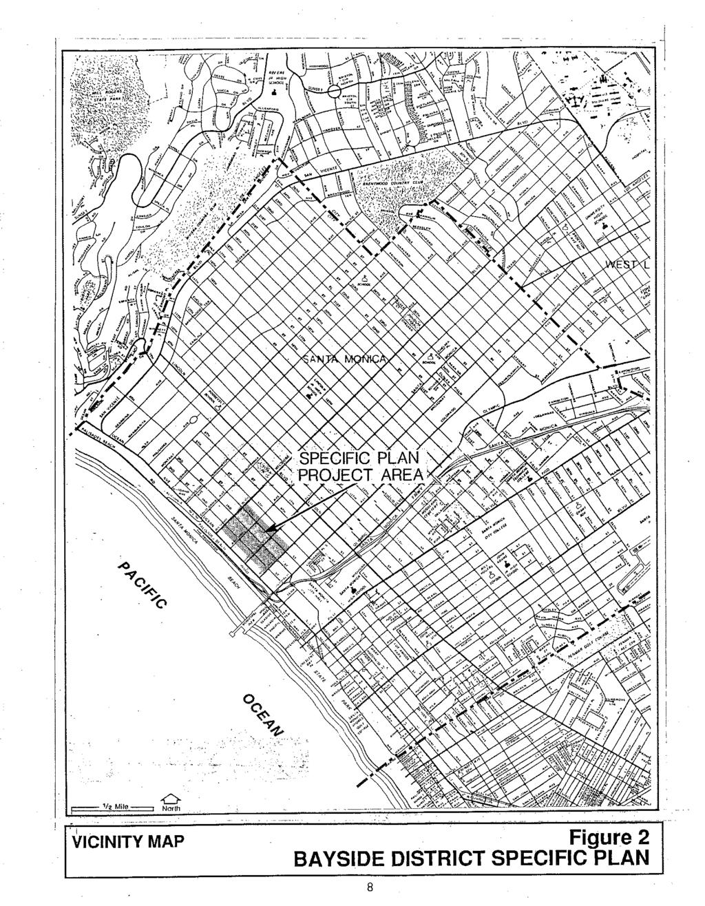
8 1.2PROJECT LOCATION The Bayside District Specific Plan project area has been expanded from the original Specific Plan boundaries. Previously the area encompassed the six blocks which abut Third Street and was bounded by the south side of Wilshire Boulevard on the north, the north side of Broadway on the south, the west side of Fourth Street on the east, and the east side of Second Street on the west. The new boundaries, as shown in Figure 1, now include the east side of Fourth Street, and the west side of Second Street. The Specific Plan area is located at the western edge of the City, approximately 15 miles west of downtown Los Angeles and adjacent to the Pacific Ocean. As shown in Figure 2, the City is surrounded by the communities of Pacific Palisades, Brentwood, West Los Angeles, Mar Vista, and Venice. The travel distances from the Promenade to other significant points in the greater Los Angeles metropolitan area are listed below. Location Marina del Rey UCLA Beverly Hills Los Angeles International Airport Downtown Los Angeles Pasadena Approximate Travel Distance 2 miles 3 miles 5 miles 6 miles 15 miles 26 miles Santa Monica is directly accessible to the Los Angeles basin to the north, east, and south by the Santa Monica (Interstate 10) and the San Diego (Interstate 405) Freeways. The Pacific Coast Highway, to the west, links Santa Monica to Malibu and the Santa Monica Mountains. 7
9
10 1.3RELATIONSHIP TO THE GENERAL PLAN The City of Santa Monica General Plan Land Use Element, adopted in 1984, recommended the preparation of a specific plan for the Third Street Promenade area. It stipulated that: The specific plan should provide detail on revitalization plans, mid-block access to public parking lots, and appropriate use of public right-of-way, and specific development standards. In addition, this plan should make specific urban design recommendations to enhance the visual character and pedestrian environment in the Downtown, and should address transit services/needs in the area. The Third Street Development Corporation (TSDC) shall have primary responsibility for preparing the Third Street Mall portion of the plan. The specific plan process will accommodate comment and discussion from property owners, residents, and business people from both the Third Street Mall and other Downtown areas, as well as other interested parties. This updated Bayside District Specific Plan continues to provide detailed development standards, design guidelines, and policies to encourage uses that attract pedestrian activity. The expansion of the project area boundaries is intended to provide a stimulus for the continued revitalization and increased pedestrian use of the streets immediately adjacent to the Promenade. The updated Specific Plan remains consistent with the intent of the Land Use Element objectives and policies for the downtown area. The primary objective for the downtown area is to "reinforce the Downtown as the focus of the City, supporting the greatest concentration of activity." The Land Use Element recommends that this be accomplished by making the downtown the primary location for commercial, entertainment, and cultural uses. 1.4 PLANNING PROCESS The City Council directed the preparation of this Specific Plan update in February 1991 with the intent that the Plan be modified to address the current concerns regarding maintenance of existing uses and activity levels, increased housing opportunities in the downtown, and continued retail growth. The process has included several community workshops held between May 1991 and August 1995 in order to solicit community identification of major planning issues that should be considered in the Plan update. 9
11 2.0 PROJECT AREA DESCRIPTION The following presents an overview of the existing conditions and significant issues associated with the Bayside District Specific Plan project area. 2.1LAND USE AND ZONING The Specific Plan project area consists of approximately 37.2 acres of land, an estimated 2.4 million square feet of private development, and 3,127 automobile parking spaces located in the public parking structures. In 1986, the existing project area square footage totaled 1.8 million square feet. Retail and offices uses comprised the majority of this development at approximately 1,239,930 square feet. Restaurant uses totaled 46,298 square feet while entertainment facilities occupied 11,549 square feet of building area. The square footage of development existing in 1986 is more fully detailed below in Figure 3. FIGURE Existing Development LAND USE ESTIMATED EXISTING IN 1986 Retail/Service 736,896 square feet Restaurant Office Residential Entertainment Institutional Bank/Finance Hotel 46,298 square feet 375,824 square feet 92,500 square feet 11,549 square feet 15,000 square feet 127,210 square feet 42,298 square feet TOTAL1,447,575 square feet Major development projects in the Specific Plan area since 1986 have been primarily office and entertainment related. As shown in Figure 4, office square footage comprises close to half of the new development in the Plan area since Out of a total of 774,190 square feet of new development, 338,804 square feet has been designated for office use. 10

12
13 As a result of the policies in the original Third Street Mall Specific Plan, entertainment and restaurant uses have increased substantially since Today, 124,210 square feet of development is entertainment related, of which 98,085 square feet is new movie theater development. A recent survey of restaurant and alcohol outlets in the downtown area found that there are 68 restaurants in Specific Plan area. Out of this group 42 facilities have alcohol licenses. The following is a summary of the key land use and zoning issues. A.The Street level of the Bayside District Specific Plan project area is largely characterized by restaurant, movie theater, and entertainment activity during both the day time and evening hours. In particular, during the evening hours the area becomes a regional activity center. This mix of uses is largely the result of the policies set forth in the 1986 Third Street Mall Specific Plan, which encouraged the development of such uses to attract patrons to the area and increase the pedestrian density. In the Promenade's new role as both a local and regional entertainment center, the following new issues have emerged: Increasing the retail component in the Specific Plan area has been identified as a high priority by both City residents and area users. Encouraging residential uses on the upper levels of multi story structures both along the Promenade and on the peripheral streets. Any additional uses located between the ground floor use and the residential units may include offices or artist studios, but these uses should serve to buffer the residential units from the street level activity. Increasing not only the housing opportunities in the area, but especially the affordable housing opportunities. Improving management of the outdoor spaces of the Bayside District area, including specifically maintenance and security. Revitalizing the 1200 block of the Promenade by attracting appropriate destination uses, including anchor retail establishments and an appropriate mix of restaurant and entertainment uses. Continuing effort to create a calendar of public events and organized activities in the Promenade public spaces which directly appeal to senior citizens, children, people from a wide variety of socio-economic backgrounds, and varying cultures. Expanding the plan area boundaries to encompass the areas immediately adjacent to the Promenade or located in the Parking Assessment District which are impacted by the area activity but are not benefited by inclusion in the Specific Plan. Providing for greater emphasis on the revitalization of Second Street, Fourth Street, and the 12
14 Promenade cross streets of Wilshire Boulevard, Arizona Avenue, Santa Monica Boulevard, and Broadway through urban design techniques, design guidelines for new construction, additional passageway linkages to the Promenade, special events, security, and maintenance. 2.2ARCHITECTURE Existing buildings within the Bayside District Specific Plan project area are characterized by a variety of architectural styles, a mix of older buildings, some with historic significance, and new construction, as well as a combination of low scale, single story buildings and multi story mixed use developments. Despite the influx of new development during the past five years, opportunities continue to exist for new construction. Emerging issues include: The Bayside District Specific Plan project area contains structures characterized by a mix of architectural styles. Many exhibit significant historic architectural details. These structures could be recognized and enhanced through rehabilitation, thereby retaining a unique and identifiable quality in the area. New project design should continue to consider the pedestrian scale and character of this downtown area, particularly at the Promenade cross streets and peripheral boundaries. Any planned building rehabilitations should be sensitive to the structure's original character, defining architectural design details and to the pedestrian environment of the Promenade. 2.3URBAN DESIGN While substantial public improvements have occurred along the Third Street Promenade, consideration of parking structure pedestrian access and the incorporation of the expanded Plan boundary areas into the district's physical and visual environment are among the additional urban design issues to be considered. These issues are as follows: Lack of clear transitions and linkages from the Promenade to the two major neighborhood off site uses, Palisades Park and the Santa Monica Pier. While physical improvements have been completed in the alley ways, such as lighting, signage, and landscaping, additional functional and design related issues remain. Common loading and trash enclosures are needed as are pedestrian entries to buildings from the alleys. 13
15 Develop strategies to extend the revitalization of economic activity to Second Street and Fourth Street as well as the cross streets by creating more effective linkages to the Promenade area, in particular, urban design mechanisms such as signage, tree lighting, maintenance services, public benches, light standards, or paving. While seven passageways linking the parking structures to the Promenade currently exist, additional connections are needed to improve accessibility to the Promenade. Passageways must be well identified through signage, decorative paving, and lighting. Develop signage and urban design elements that identify Santa Monica Boulevard as the terminus of the historic Route PARKING AND CIRCULATION A parking inventory prepared by the Parking and Traffic Division for the downtown parking assessment district determined that a total of 3,127 parking spaces and 9 motorcycle spaces are located in the City owned public parking structures. Of these spaces, approximately one-third, or 1,133 spaces as well as all 9 motorcycle spaces, are metered for four hour use. Over one-third, or 1353 spaces, are designated as twelve hour spaces. The permit only parking spaces have been eliminated and the 154 parking spaces that may be used by permit holders are also available as four hour metered spaces. A total of 487 spaces are restricted as leased parking spaces. Since the preparation of the parking inventory, the meters in the six City owned parking structures have been removed and the structures have been converted to attendant parking. In addition, a total of 1906 parking spaces are located in privately owned parking facilities within the assessment district. These facilities range in size from 7 spaces to 340 spaces located in a subterranean parking garage. A map identifying the location of the private facilities is contained in Figure 6 and a list of the locations by address is contained in Figure 7. 14
16
17
18 FIGURE 7 BAYSIDE DISTRICT OFF-STREET PARKING INVENTORY LOT DESCRIPTION CAPACITY A301 Broadway, Janss Court 193 B1455 Fourth Street, alley parking 27 C1432 Fourth Street, alley parking 26 DA Fourth Street, alley parking 12 E1427 Third Street Promenade, alley parking 11 F331 Santa Monica Boulevard, Home Savings 15 G1347 Fourth Street, alley parking 28 H1333 Fourth Street, Great Western Savings 36 I1301 Fourth Street, Bank of America 52 J1212 Fourth Street, surface lot 26 K402 Wilshire, office building 17 L Second Street, J.C. Penny's 95 N1299 Ocean Avenue, office building 340 O1301 Second Street, alley parking 12 P Second Street, surface parking 25 Q201 Santa Monica Boulevard, office building 260 RNorthwest Corner Second and Santa Monica Boulevard surface lot 95 S1401 Second Street, alley parking 15 T223 Broadway, alley parking 7 U1250 Fourth Street, Security Pacific Bank 312 V307 Arizona, Miko Building 14 W1331 Second Street, office building 262 X Third Street Promenade, Van Tilburg Building 18 17
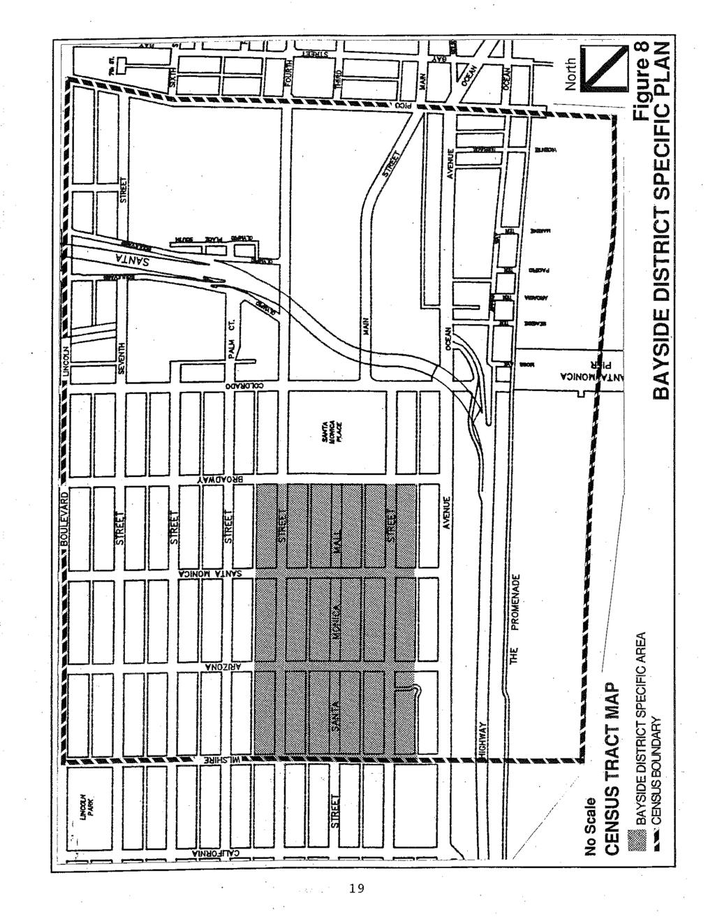
19 A parking demand analysis was prepared for the downtown structures in May The usage survey conducted determined the peak weekday and weekend utilization periods. The study showed that on weekdays the peak utilization for the six parking structures occurs between 1 p.m. and 2 p.m. when 1,892 spaces, or 62 percent of the available non-permit non-leased spaces are occupied. The peak weekend demand occurs at night between 9 p.m. and 10 p.m. when 1,923 spaces, or 63 percent of the available spaces are occupied. While the study has shown that sufficient parking exists in the area, concerns remain regarding the following issues; A number of parking structures are not directly linked by passageways to the Promenade and some that exist are not well signed and/or are unattractive. All passageways should remain open during evening hours. The location of the parking spaces available in private facilities is not adequately marked and no program exists to insure these facilities are made available to the general public. The parking structures require upgrading; in particular, the elevators, lighting system, lobbies, restrooms, and signage graphics should be improved. 2.5SOCIOECONOMIC CHARACTERISTICS This section summarizes the demographic characteristics available from the 1990 Census for the census tract in which the Specific Plan project area is located. A map of the census tract area is contained in Figure 8. The population in the area declined by 5.7 percent between 1980 and 1990, with a total of 2,621 residents in 1980 and 2,472 in In addition, the number of housing units in the area also decreased, from 2,129 units in 1980 to 1,896 units in 1990, a 10.9 percent change. However, in the Specific Plan project area the number of housing units increased by 32 units. An additional 80 single room occupancy units have been approved for construction. 18
20
21 3.0 PLAN FRAMEWORK: GOALS, GENERAL OBJECTIVES AND THEME Functioning as the framework for this Specific Plan update is the goal, the general objectives, and the development theme which serve as the guideposts for the continued revitalization and management of the area. This section provides the basic framework for the set of detailed objectives and policies that follow in Sections 4 through GOAL It shall be the goal of the City of Santa Monica to continue to revitalize the Bayside District area, in particular the 1200 block of the Promenade, as well as Second Street and Fourth Street and the cross streets of Wilshire Boulevard, Arizona Avenue, Santa Monica Boulevard, and Broadway. The revitalization plan should enhance and contribute to the unique qualities of the Bayside District and to its role as the principal center of community activity in Santa Monica. The Bayside District is notable in the Los Angeles area for its pedestrian oriented, open air environment. The Specific Plan should give special attention to nurturing the character of the Bayside District as a safe, comfortable, attractive and affordable center for dining, entertainment, and cultural and retail activity which serves persons of all ages who are from diverse social and economic strata, varied cultures, races and ethnicities, and who possess a range of interests. Sufficient office space and residential uses should be provided to supply the economic base for these community oriented activities. 3.2GENERAL OBJECTIVES A.Improve the economic and physical relationship of the Third Street Promenade as well as the entire Bayside District to major peripheral uses and destinations. B.Attract and accommodate a mix of uses which serve the daytime and evening Bayside District residents, City-wide residents, as well as the many tourists and visitors to the Santa Monica area. C.Accommodate new development compatible with the existing scale and character of the Bayside District, including the Third Street Promenade and surrounding streets within the Specific Plan boundaries. D.Improve the physical and environmental character of the alleys consistent with their use as service, access, and pedestrian thoroughfares. E.Perform adequate infrastructure and traffic circulation improvements to accommodate demands generated by the expanded use of the Bayside District Specific Plan area. 20
22 F.Provide a full range of transportation alternatives to and from the Promenade area. G.Stimulate economic activity in the Bayside District area and the generation of new job and business opportunities for community residents. H.Encourage uses and urban design elements on Second Street that will generate pedestrian and expanded retail activity and uses on Fourth Street that are compatible with its character as a transportation corridor into the downtown. I.Emphasize the need for additional retail services for area residents, office workers, as well as the visitor population. J.Encourage and provide incentives for the development of housing within the Specific Plan area, particularly on Second Street and Fourth Street where there are more opportunities for development. 3.3DEVELOPMENT THEME Santa Monica's Bayside District is a unique area with a combination of older buildings and new construction, entertainment, retail, restaurant, and business facilities as well as housing opportunities and pedestrian oriented public spaces located in an inviting outdoor setting. It represents one of the few open air, pedestrian oriented, commercial and residential environments in an oceanfront community in Southern California that is designed to serve both local residents and visitors to the area who possess a range of interests, diverse social and economic backgrounds, and varied reasons for being drawn to the many activities available in the District. These distinguishing attributes provide a character and quality, or theme, which can and should be enhanced to continue to make the Bayside District a vital community center and an area which succinctly defines Santa Monica's character. New developments, uses, building rehabilitations, public spaces, and design styles should be consistent with, as well as promote, this central theme. 3.4SPECIFIC PLAN FORMAT This Bayside District Specific Plan presents the detailed objectives and policies for nine elements: Land Use, Open Space, Parking and Circulation, Housing, Noise, Seismic Safety, Public Safety, Conservation, and Historic Preservation. The Specific Plan objectives and policies are organized in Elements similar to those contained in the City's adopted General Plan since the Specific Plan objectives and policies are intended to be consistent with and supplement General Plan objectives and policies by providing greater specificity and detail for the Bayside District Specific Plan project area. 21
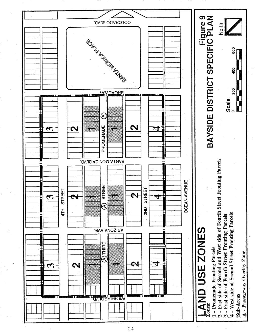
23 4.0 SPECIFIC PLAN LAND USE ELEMENT The Land Use Element of the Bayside District Specific Plan is presented in two subsections. The first describes the overall concepts and structure of uses for the planning area and the second presents the detailed objectives and policies. These objectives and policies include and expand upon the objectives and policies contained in the City's General Plan Land Use Element. LAND USE OVERVIEW The Bayside District Specific Plan provides for the maintenance and management of existing activity in the Plan area, while continuing to encourage the expansion of revitalization on Wilshire Boulevard, Arizona Avenue, Santa Monica Boulevard, Broadway, Second Street and Fourth and in the north block of the Third Street Promenade. The Bayside District continues to be conceived as the central core of the City and as the City's primary shopping and entertainment area. The district is intended to accommodate the daily and special shopping needs of nearby and district residents, to serve as an outdoor destination point for both residents and visitors, and to provide for new housing opportunities, office space, and dining, entertainment and cultural facilities. The Specific Plan emphasizes the renovation and reuse of structures which display unique or historically important architectural or historic details. Any new construction shall be sensitive to and compatible with adjacent structures. As in the 1986 adopted Specific Plan, which stated that "...with the exception of a number of key sites, the existing Mall structures be retained, renovated, and/or adaptively reused or replaced with new structures of similar scale and character...", the Plan stresses the preservation of identified cultural resources and provides for policies and design guidelines to insure new construction is compatible with adjacent structures and the area's pedestrian character. Structures that have been identified as priorities for preservation are listed by address in the Specific Plan Historic Preservation Element. The Plan limits ground floor uses along the Promenade to those which are pedestrian oriented. Among these are general and specialty retail, retail services, restaurants, entertainment, and cultural uses. Office, residential units, and other uses which are not pedestrian intensive are permitted on the upper floors. In addition, the ground floor of Promenade facing structures are permitted to be divided for a second retail, office, or service use with access provided from the alley. On streets in the Bayside District Specific Plan area other than the Third Street Promenade, the Plan permits pedestrian oriented uses but, in addition, allows uses that are less pedestrian oriented such as offices at the rear third of a ground floor storefront, financial institutions, and personal and convenience services. Residential uses are also encouraged in this area through the provision of a height and floor area ratio bonus in exchange for the construction of housing units. The project area zones and subarea overlay zones established in the 1986 Plan have been consolidated and simplified. The Plan now provides for four primary zones and one overlay zone. Zone 1 is the designation for Promenade fronting parcels. Policies in this area are intended to allow 22
24 for uses which create an interesting, active and human scale environment for pedestrians while enhancing the interaction between the second story commercial and residential uses and the Promenade open space. Zones 2 and 3 establish policies for the Plan areas peripheral to the Promenade. These are the parcels fronting on the east side of Second Street and both sides of Fourth Street. This area is intended to reinforce and complement the activity and uses located on the Promenade through a combination of pedestrian oriented and service related retail businesses. In addition, incentives are provided to encourage the provision of affordable housing in this zone. Zone 4 establishes policies for the Plan area located on the west side of Second Street. Permitted uses in this area are the same as for Zones 2 and 3, however, the building height and floor area ratio requirements remain consistent with the underlying C3 zoning. The Passageway Overlay Zone, Subarea A, encourages the provision of passageway structures to serve as links between the public parking structures and the promenade. In exchange for dedicating an easement to the City for a public passageway the developer receives a height and density bonus. A map of the land use zones is contained in Figure 9. OBJECTIVES AND POLICIES This section contains the Specific Plan objectives and policies which govern development in the Bayside District Specific Plan project area. The Specific Plan also incorporates policies which are contained in the General Plan Land Use Element. Additional policies are contained in this section which complement and provide more specific policy guidance for the Bayside District Specific Plan project area. 4.1OBJECTIVE Recognizing the important role the Bayside District can play in making Downtown the activity focus of the City, encourage the maintenance of existing facilities on the Third Street promenade and the expansion of retail uses, housing, and additional urban design elements throughout the Bayside District. Goods, services, and urban design features should be provided which address the needs of both existing residents living near and in the Bayside District and a wide range of consumers visiting the District. 23
25
26 GENERAL POLICIES Types of Uses 4.1.1Concentrate retail uses and other complementary uses (such as hotels, offices, cultural facilities, restaurants, social services, and housing) on or near the Third Street Promenade as necessary to maintain a vibrant downtown environment Require that the ground floor street frontage be devoted to pedestrian oriented uses on Second Street and Fourth Street between Broadway and Wilshire Boulevards and on Broadway (north side) and Wilshire Boulevard between Second and Fourth Street (General Plan LUCE Policy 1.4.2) Provide for the development of uses as necessary to maintain the economic viability of the Bayside District, including retail and specialty commercial uses, eating establishments, entertainment facilities (theaters, clubs, etc.), and professional offices Provide for the development or preservation of uses which serve neighborhood needs Allow for the renovation and/or development of new housing above the first floor of existing or new structures Encourage the development of professional offices, personal and business services, entertainment, restaurants, cultural, educational, health facilities, artist studios, and other related uses above the first floor of structures throughout the Bayside District Introduce improvements and uses which enhance the Promenade's ability to capture the significant residential and tourist market Encourage the expansion of existing uses and the introduction of new uses to provide new job opportunities for the community The number of on-sale alcohol outlets and food serving establishments in the Bayside District shall be limited on a block by block basis in order to provide for a mix of activities including retail and entertainment, and to prevent an over concentration of food serving and alcohol outlets. Cultural Facilities, Events, and Promenade Public Space Promote appropriate retail and cultural activity within the Promenade right-of-way (Farmers Market, outdoor cafes, performing and visual arts, etc.) (General Plan LUCE Policy 1.4.3) 25
27 4.1.11Promote new cultural activities and uses within the Promenade space and/or adjacent structures Provide an annual calendar of events for the Bayside District area Promote uses in the Promenade public space which are physically and visually compatible with adjacent structures and integral to the overall organization and form of outdoor spaces, such as pushcarts selling food or other retail items, seasonal holiday entertainment or activities, or special events Provide for the continuation of uses which attract nighttime use of the Promenade, such as movie theaters, cultural performance halls, restaurants, and entertainment facilities Ensure the continuation of an open air Farmers Market and other special outdoor events by designing future Bayside District improvements to be compatible with these activities Maintain a management organization and program to coordinate Promenade promotions, activities, and maintenance. Project Design and Development Provide for the retention and/or adaptive reuse of existing structures of significant architectural styles and/or historic interest in accordance with the Bayside District Architectural Design Guidelines Permit the division of the ground level of existing structures and accommodate in their alleyfacing portion, offices, service, or retail uses which are not pedestrian intensive Require that 70 percent of any Promenade or street facade to a height of 10 feet be visually transparent and physically accessible to enhance observation and pedestrian access unless precluded by significant architectural design details of existing buildings Require that unreinforced masonry structures be upgraded where necessary to meet applicable City of Santa Monica seismic standards Permit the replacement of existing buildings and ensure that those which are newly constructed are compatible with existing buildings and comply with the Bayside District Architectural Design Guidelines Within the parameters of this document, provide the opportunity for the development of 26
28 individual structures of higher intensity at selected locations in order to facilitate pedestrian activity on the Promenade There shall be no limitation on the number of stories of any hotel, parking structure, or structure containing at least one floor of residential use, so long as the height does not exceed the maximum number of feet permitted in the District The minimum parcel size for new parcels in the Bayside District Specific Plan area shall be 7,500 square feet In order to monitor development trends in the Bayside District Specific Plan area, the Planning and Community Development Department shall prepare an annual report to City Council which indicates the amount of new development that has been applied for, approved or developed in the Bayside District. When net new development reaches 450,000 square feet, the City Council shall direct staff to review the environmental conditions of the area. Based on the analysis of the environmental conditions, the Council shall determine whether the development standards for the area should be modified. Development applications shall be processed and approved according to existing zoning standards during the pendency of such analysis, until such time as the Council takes action to revise development standards, or otherwise place a limit on the amount of new development. 27
29 PROMENADE FRONTING PARCEL (ZONE 1) POLICIES Permit buildings to be constructed to a maximum height of 56 feet or four stories. Portions of buildings above 30 feet in height shall be stepped back in order to maintain solar access, minimize the perceived mass of structures, and to maintain the existing character of the Promenade Permit buildings to be constructed to a maximum floor area ratio of Allow encroachments of up to 12 feet into the Promenade from the abutting property frontage to accommodate outdoor dining. Uses located in the Promenade encroachment zone shall be in accordance with the approved Third Street Promenade Outdoor Dining Standards subject to an encroachment permit. The complete outdoor dining guidelines are contained in Appendix A The ground floor of a structure may be divided to accommodate uses that provide primary access from the alley, incorporate the alley address on the building facing the alley, and include an entry, identification sign, and windows which are compatible with the overall design character of the building To encourage the continuity of "live" retail sales and services, at least seventy (70) percent of the total width for the first 12 feet of elevation of any new or reconstructed building, parallel to and facing the Promenade, shall be devoted to entrances, show windows, or other displays which are of interest to pedestrians, unless precluded by the presence of significant existing architectural features. Where substantial length of windowless wall is found to be unavoidable, eye-level display, a contrast in wall treatment, an offset wall line, decorative features, outdoor seating and/or landscaping shall be used to enhance visual interest and pedestrian vitality Clear untinted glass shall be used at the ground floor promenade level to allow maximum visual access to the interior of buildings. Mirrored and highly reflective glass shall not be permitted at any level of structure Walk-up facilities shall be recessed and provide adequate queuing space to avoid interruption of the pedestrian flow Any security grills at the street level shall be designed as an integral component of the building, shall be of the roll-down type, shall have an open web sufficient to provide visibility to the interior when the grill is in the closed position, and shall be placed to the interior of the outside glass. 28

30
31 PARCELS FRONTING THE EAST SIDE OF SECOND STREET AND THE WEST SIDE OF FOURTH STREET (ZONE 2) Permit buildings to be constructed to 4 stories and 56 feet. Portions of buildings above 30 feet in height shall be stepped back in order to maintain solar access, minimize the perceived mass of structures, and to maintain the pedestrian character of the Specific Plan area Permit buildings to be constructed to a maximum floor area ratio of With approval of a Development Review Permit, allow additional height of up to 84 feet and additional floor area ratio of up to 3.5 provided that the top two floors are used exclusively for residential purposes, all inclusionary units are provided on site, and residential parking as required by Municipal Code Section is provided on site. During the Development Review process, the Planning Commission shall consider the potential for creating a "canyon" effect along Fourth Street. A project that involves the construction or expansion of a City owned public parking structure shall be permitted to be constructed up to 84 feet in height without the approval of a Development Review Permit All uses located below grade except for parking shall be counted as floor area Floor area devoted to residential uses shall be discounted by 50 percent for the purposes of floor area ratio calculations Where feasible, provide the opportunity for development of commercial uses within the public parking structures at the ground floor. 30

32
33 PARCELS FRONTING THE EAST SIDE OF FOURTH STREET (ZONE 3) Permit buildings to be constructed to 4 stories and 56 feet. Portions of buildings above 30 feet in height shall be stepped back in order to maintain solar access, minimize the perceived mass of structures, and to maintain the pedestrian character of the Specific Plan area Permit buildings to be constructed to a maximum floor area ratio of With approval of a Development Review Permit, allow additional height of up to 84 feet and additional floor area ratio of up to 3.5 provided that the top two floors are used exclusively for residential purposes, all inclusionary units are provided on site, and residential parking as required by Municipal Code Section is provided on site. During the Development Review process, the Planning Commission shall consider the potential for creating a "canyon" effect along Fourth Street All uses located below grade except for parking shall be counted as floor area Floor area devoted to residential uses shall be discounted by 50 percent for the purposes of floor area ratio calculations Where feasible, proved the opportunity for development of commercial uses within the public parking structures at the ground floor. 32
34
35 PARCELS FRONTING THE WEST SIDE OF SECOND STREET (ZONE 4) Permit buildings to be constructed to 3 stories and 45 feet. Portions of buildings above 30 feet in height shall be stepped back in order maintain solar access, minimize the perceived mass of structures, and to maintain the pedestrian character of the Specific Plan area Permit buildings to be constructed to a maximum floor area ratio of Floor area devoted to residential uses shall be discounted by 50 percent for the purposes of floor area ratio calculations. 34

36
37 PASSAGEWAY OVERLAY ZONE (SUB-AREA A) All underlying land use policies apply unless superseded by the following: Only one new public passageway shall be permitted on each side of each block. Public passageways existing on the effective date of this Specific Plan shall not count toward this limitation Require a vertical stepback above 30 feet in order maintain solar access, minimize the perceived mass of structures, and to maintain the pedestrian character of the Promenade When a passageway is provided, permit the passageway mixed-use structure to be constructed to a maximum floor area ratio of 3.5 on parcels of 15,000 square feet or less, excluding the passageway. Permit a maximum floor area ratio of up to 3.5 on parcels over 15,000 square feet only with approval of a Development Review permit Require that the passageway area be dedicated as an easement to the City of Santa Monica. Dedicated passageways shall be a minimum of 12 feet in width. The public passageway shall be well lighted and visually unobstructed from the Promenade to the alley to insure the safety and comfort of passageway users Permit structures to be constructed to maximum height of 84 feet when a passageway is provided. The top two stories must be devoted exclusively to residential use. 36
38
39 5.0 SPECIFIC PLAN OPEN SPACE ELEMENT The objectives and policies of the Open Space Element of the Bayside District Specific Plan are as follows: OBJECTIVE 5.1Maintain the physical character and image of the Bayside District to insure continued pedestrian use and community activity. POLICIES 5.1.1Establish a program and schedule to ensure regular maintenance of existing Specific Plan area amenities such as streetscape and landscape elements, signage, light standards, benches, bicycle racks, drinking fountains, phone booths and trash receptacles Provide space within the Promenade for outdoor performances, public assemblies, and art displays Provide opportunities for services and uses on the Promenade which cater to the special needs of the elderly and children. OBJECTIVE 5.2Enhance the relationship among the three blocks along the Promenade and the relationship between individual buildings and the Promenade public common area. POLICIES 5.2.1Provide adequate information for Promenade users regarding the location of businesses, parking structures, transit, and major destinations outside of the downtown area, including frequent updates of the business directories and increasing the number of directional and information signs Provide for commercial uses in the Promenade public space including outdoor dining and push carts Establish standards to encourage a variety of street performers while maintaining a balance with Promenade patrons and residents. 38
40 OBJECTIVE 5.3Improve the physical and environmental character of the alleys consistent with their use as service, access, and pedestrian thoroughfares. POLICIES 5.3.1Improve the facades and setbacks of Promenade buildings facing the alleys with new design elements, materials, and landscaping Encourage pedestrian entries to buildings from the alleys Improve the physical pedestrian crossings and surfaces of the alleys Establish common areas for loading zones and trash enclosures along Mall Court West and Mall Court East. OBJECTIVE 5.4Improve the physical relationship of the Third Street Promenade with the entire Specific Plan area and major peripheral uses and destinations. POLICIES 5.4.1Establish definable entries from peripheral streets and uses in the Specific Plan area Improve and expand the system of linkages between the Specific Plan area and the parking structures Provide improved landscaping, paving and signage along Wilshire Boulevard, Arizona Avenue, Santa Monica Boulevard, and Broadway to visually and physically link the Promenade with the Palisades Extend the Promenade streetscape and signage to peripheral streets to visually link the Promenade with its immediate surroundings in the Bayside District Provide pedestrian, bicycle, and shuttle linkages between the Bayside District and the Santa Monica Pier, Main Street, and the Civic Center Introduce a coordinated signage program throughout the Specific Plan area which defines points of interest, public and private parking facilities, and key destinations points within the downtown area. 39
41 6.0 SPECIFIC PLAN PARKING AND CIRCULATION ELEMENT PARKING AND CIRCULATION OBJECTIVES AND POLICIES The objectives and policies which govern the Parking and Circulation Element of the Bayside District incorporate those relevant objectives and policies from the City of Santa Monica's Land Use and Circulation Element. A.CIRCULATION OBJECTIVE 6.1Provide a balanced circulation program which serves future land use needs consistent with: City's ability to finance and maintain. Satisfying accessibility needs of the City's residents, including the poor, elderly, and disabled. Minimizing and mitigating negative environmental effects (General Plan Circulation Element Objective 4.1). POLICIES 6.1.1All circulation improvements shall be in accordance with the Circulation Plan Maps (General Plan Circulation Element Policy Element Policy 4.1.1) The City shall encourage overall land use patterns which reduce vehicle miles traveled and number of trips (General Plan Circulation Element Policy 4.1.2) Land use and public facilities and services should be located and designed for convenient access and efficient transport of all intended users (General Plan Circulation Element Policy 4.1.3) The City shall support the implementation of short- and long-range transportation measures for reducing air pollution from transportation sources as recommended by the South Coast Air Quality Management District (General Plan Circulation Element Policy 4.1.4) Effects of transportation-general noise shall be mitigated to comply with the policies and standards in the City's Noise Element (General Plan Circulation Element Policy 4.1.5) The City shall encourage transportation alternative consistent with the Transportation Management Plan to reduce the use of fossil fuels (General Plan Circulation Element Policy 40
42 4.1.7) The City shall support transportation alternatives consistent with the Transportation Management Plan which reduce use of land for parking (General Plan Circulation Element Policy 4.1.7) The City shall provide bicycle racks on the Promenade common area and in the public parking structures consistent with the requirements in the Bicycle Master Plan In order to protect the north of Wilshire residential neighborhood from Bayside District related overflow parking, the City shall assist in the establishment of a preferential parking district. B.PUBLIC TRANSIT OBJECTIVE 6.2Encourage the use of public transit through an improved system which can include downtown shuttles, expanded bus lines, light rail, and transit user amenities and incentives. POLICIES 6.2.1The City will continue to coordinate transit planning with the Southern California Associate of Governments (SCAG), the Los Angeles County Transportation Commission (LACTC), and the Metropolitan Transportation Authority (MTA) (General Plan Circulation Element Policy 4.5.1) The City endorses the concept of rail rapid transit, either heavy or light rail, serving the City of Santa Monica and shall promote locating a transit station in the Downtown area. The City should select the most appropriate type of transit system and the most appropriate route after public review and consideration of the options available to the City (General Plan Circulation Element Policy 4.5.2) The City endorses Wilshire Boulevard as a major bus transit corridor which could potentially be upgraded for mass transit in the future (General Plan Circulation Element Policy 4.5.2) Future mass transit planning shall be coordinated with regional mass transit planning efforts (General Plan Circulation Element Policy 4.5.4). 41
Policies and Code Intent Sections Related to Town Center
 Policies and Code Intent Sections Related to Town Center The Town Center Vision is scattered throughout the Comprehensive Plan, development code and the 1994 Town Center Plan. What follows are sections
EXISTING COMPREHENSIVE PLAN
 EXISTING COMPREHENSIVE PLAN Town Center Land Use Element: V. LAND USE POLICIES Town Center Mercer Island's business district vision as described in "Your Mercer Island Citizen-Designed Downtown" was an
City of Farmington. Downtown Plan. Amendment to the 1998 Master Plan Adopted October 11, 2004
 City of Farmington Amendment to the 1998 Master Plan Adopted October 11, 2004 Introduction Planning Background 1 Scope and Components of the Plan Amendment 2 Concept Introduction 3 Plan Concepts 3 Conceptual
Planning Commission Report
 Planning Commission Report To: From: Subject: Planning Commission Meeting: January 6, 2016 Agenda Item: 8-B Planning Commission David Martin, Planning & Community Development Director Introduction to the
3.0 LAND USE PLAN. 3.1 Regional Location. 3.2 Existing Conditions Existing Uses. Exhibit Regional Location Map
 3.0 LAND USE PLAN 3.1 Regional Location The Anaheim Resort Specific Plan (ARSP) area is located in the City of Anaheim, which is 35 miles southeast of downtown Los Angeles and 7 miles northwest of Santa
Town Center (part of the Comprehensive Plan)
") Town Center (part of the Comprehensive Plan) Mercer Island Town Center Looking North (2014) In 1994, a year-long process culminated in a set of design guidelines and code requirements for the Town Center
Town Center (part of the Comprehensive Plan) Mercer Island Town Center Looking North (2014) In 1994, a year-long process culminated in a set of design guidelines and code requirements for the Town Center
Santa Monica Chamber of Commerce DSP Subcommittee s DSP EIR Scoping Comments and Preliminary Comments on the DSP Framework
 Santa Monica Chamber of Commerce DSP Subcommittee s DSP EIR Scoping Comments and Preliminary Comments on the DSP Framework The Chamber of Commerce s DSP Subcommittee s comments on the scope of the DSP
Carlsbad Village Redevelopment Concept Summary of Features
 Carlsbad Village Redevelopment Concept Summary of Features Calthorpe Associates November 5, 2003 The Redevelopment Concept illustrates a vision for the future of Carlsbad Village. The overall vision of
Table of Contents. Elm Avenue Improvement Plan City of Waco, Texas. Introduction 1. Existing Context 1 Figure 1 2.
 Table of Contents Introduction 1 Existing Context 1 Figure 1 2 Plan Guidelines 3 Future Urban Form 4 The West-End 4 Main Street 6 The East-End 7 Figure 2 9 Public Improvement Recommendations 7 General
Metro. Activity Center Design Guidelines. Recommendations For Developing Focused, Mixed-Use Commercial/Residential Centers
 Metro Activity Center Design Guidelines Recommendations For Developing Focused, Mixed-Use Commercial/Residential Centers Metro Activity Centers What is a MAC? Legacy, the adopted guide for the future growth
ARLINGTON COUNTY, VIRGINIA
 ARLINGTON COUNTY, VIRGINIA County Board Agenda Item Meeting October 15, 2005 DATE: September 28, 2005 SUBJECT: Request to Advertise the adoption of the 2005 Clarendon Sector Plan C. M. RECOMMENDATION:
Be it enacted by the Town Board of the Town of Guilderland that the following new A (Transit Oriented Development (TOD) District) is adopted:
 District) is adopted:") Local Law No. 4 of 2018 (Adoption of 280-18A (Transit Oriented Development District) Be it enacted by the Town Board of the Town of Guilderland that the following new 280-18A (Transit Oriented Development
Local Law No. 4 of 2018 (Adoption of 280-18A (Transit Oriented Development District) Be it enacted by the Town Board of the Town of Guilderland that the following new 280-18A (Transit Oriented Development
Community Design Plan
 Gardena General Plan 2006 Authority While the is not a required element of a General Plan, it is included because improving the community appearance and image is paramount to the overall quality of life
Mark-up of the effect of the proposed Bronte Village Growth Area OPA No.18 on the text of section 24, Bronte Village, of the Livable Oakville Plan
 Mark-up of the effect of the proposed Bronte Village Growth Area OPA No.18 on the text of section 24, Bronte Village, of the Livable Oakville Plan Notes: This document is provided for information purposes
A. OVERVIEW OF ENVIRONMENTAL SETTING
 IV. A. OVERVIEW OF The proposed site is comprised of three parcels totaling approximately 4.24 acres, situated southwesterly of the intersection of Weyburn and Tiverton Avenues. Parcel A is 2.72 acres
LAND USE OVERVIEW WHAT YOU WILL FIND IN THIS CHAPTER
 LAND USE WHAT YOU WILL FIND IN THIS CHAPTER Information about the City s expected population and employment growth. Description and capacity of existing and future land use designations. Policies that
Table L-1 Summary Action Strategy. Action Item Timing Status Responsible Agency
 CHAPTER 4: CIRCULATION ELEMENT ISSUE #1: MAJOR THOROUFARES AND TRANSPORTATION ROUTES A balanced transportation system for Fontana is provided that meets the mobility needs of current and future residents
4- PA - LD - LIVELY DOWNTOWN. LD - Background
 4- PA - LD - LIVELY DOWNTOWN LD - Background The downtown has been the service centre for the community since the city s inception and the area continues to supply people with their personal services,
The transportation system in a community is an
 7 TRANSPORTATION The transportation system in a community is an important factor contributing to the quality of life of the residents. Without a sound transportation system to bring both goods and patrons
GREENING THE BOULEVARD Master Plan Concepts for Venice Boulevard between Lincoln and Sawtelle
 GREENING THE BOULEVARD Katherine Spitz Associates Inc. 4212½ Glencoe Avenue Marina Del Rey, CA 90292 310 574 4460 Fax 574 4462 January 2008 Table of Contents Overview Proposed Design Improvements Illustration
CITY OF PUYALLUP. Background. Development Services
 CITY OF PUYALLUP Development Services 333 South Meridian Puyallup WA 98371 To: City Council From: Katie Baker, AICP, Planning Division Re: South Hill Neighborhood Plan Adoption Date: (Meeting date: February
Land Use Amendment in Southwood (Ward 11) at and Elbow Drive SW, LOC
 at and Elbow Drive SW, LOC") 2018 November 15 Page 1 of 10 EXECUTIVE SUMMARY This land use amendment application was submitted by Rick Balbi Architect on 2017 August 31 on behalf of Sable Developments Ltd, and with authorization from
2018 November 15 Page 1 of 10 EXECUTIVE SUMMARY This land use amendment application was submitted by Rick Balbi Architect on 2017 August 31 on behalf of Sable Developments Ltd, and with authorization from
M E M O R A N D U M PLANNING AND COMMUNITY DEVELOPMENT DEPARTMENT CITY OF SANTA MONICA CITY PLANNING DIVISION
 M E M O R A N D U M PLANNING AND COMMUNITY DEVELOPMENT DEPARTMENT CITY OF SANTA MONICA CITY PLANNING DIVISION DATE: March 12, 2018 TO: FROM: SUBJECT: The Honorable Landmarks Commission Roxanne Tanemori,
Draft Memorandum #1: Goals and Vision for Revitalization
 Keizer Revitalization Plan Draft Memorandum #1: Goals and Vision for Revitalization Submitted to: City of Keizer April 12, 2018 (revised) Prepared By: Angelo Planning Group and Otak, Inc. Project No. 17482.A
MIXED-USE VILLAGE OVERLAY FLOATING DISTRICT
 MIXED-USE VILLAGE OVERLAY FLOATING DISTRICT Zoning regulations developed by committee to the Planning Board for the Town of DeWitt, NY Issue date: 13 July 2017 revised 3/12/2018, revised 4/26/2018, 5/9/2018
FRUITVALE TRANSIT VILLAGE (Phase 2) Residential Project
 Residential Project") FRUITVALE TRANSIT VILLAGE (Phase 2) Residential Project DEVELOPER: SIGNATURE PROPERTIES ARCHITECT: HKIT ARCHITECTS April 23, 2010 TABLE OF CONTENTS 3 Vision 4 Description of Site 5 Guiding Concepts 6
FRUITVALE TRANSIT VILLAGE (Phase 2) Residential Project DEVELOPER: SIGNATURE PROPERTIES ARCHITECT: HKIT ARCHITECTS April 23, 2010 TABLE OF CONTENTS 3 Vision 4 Description of Site 5 Guiding Concepts 6
Today Land & People. Northeast Nampa Gateway District. Employment. Land Use Characteristics. Demographics. Current Zoning
 Today Land & People Employment Major employers include Saint Alphonsus, the College of Western Idaho, the Auto Mall, Sorrento Lactalis and Walmart. 3,004 jobs in 2010 (COMPASS-CIM 2040 TAZ data) 4,345
Downtown Streetscape Manual & Built Form Standards
 City of Guelph Downtown Streetscape Manual & Built Form Standards July 2014 Prepared by Brook McIlroy Inc. in association with Unterman McPhail Associates and McCormick Rankin Inc. City of Guelph Downtown
Sheridan Boulevard S TAT I O N A R E A P L A N S H E R I D A N B O U L E VA R D S TAT I O N A R E A P L A N
 Sheridan Boulevard S TAT I O N A R E A P L A N 1 City of Lakewood Adopted November, 2006 S H E R I D A N B O U L E VA R D S TAT I O N A R E A P L A N The Vision The City of Lakewood s overall vision is
Chapter 1: Introduction
 Chapter 1: Introduction The Penn Avenue Community Works Corridor Vision and Implementation Framework presents an integrated communitybased vision and a coordinated, long-term implementation framework for
TRANSIT NEIGHBORHOOD PLANS PROGRAM OVERVIEW
 TRANSIT NEIGHBORHOOD PLANS PROGRAM OVERVIEW OCTOBER 2017 Los Angeles Department of City Planning @LATNP and @Planning4LA Outline Introduction Policy Framework The Transit Neighborhood Plans Program Overview:
III. PROJECT DESCRIPTION
 III. PROJECT DESCRIPTION LOCATION AND BOUNDARIES The City of Manhattan Beach is located in the South Bay region of Los Angeles County, California, approximately 2 miles south of the Los Angeles International
Draft Bergamot Area Plan
 ATTACHMENT 1 Draft Bergamot Area Plan Taskforce on the Environment April 15, 2013 www.bergamotplan.net 1 Overview WHAT IS THE BERGAMOT AREA PLAN? A Community-Based Planning Document Guiding the Future
The Village of Shirlington
 The Village of Shirlington Suburban Smart Growth Without Rail Transit July 2018 Agenda History (1940 to present) Attributes and Outcomes Lessons Learned Setting the Stage Arlington County Arlington is
Pedestrian and Bike Bridge LOGO
 6.2.2 Pedestrian and Bike Bridge The proposed pedestrian and bike crossing re-envisions the existing bridge at Pismo Creek on Cypress Street. The bridge is currently underutilized by vehicular through
SUBJECT: PREDEVELOPMENT PLAN REVIEW OF PROJECT LOCATED AT E. COLORADO BOULEVARD (PASEO COLORADO)
") TO: FROM: Honorable Mayor and City Council Planning & Community Development Department SUBJECT: PREDEVELOPMENT PLAN REVIEW OF PROJECT LOCATED AT 260-400 E. COLORADO BOULEVARD (PASEO COLORADO) RECOMMENDATION:
TO: FROM: Honorable Mayor and City Council Planning & Community Development Department SUBJECT: PREDEVELOPMENT PLAN REVIEW OF PROJECT LOCATED AT 260-400 E. COLORADO BOULEVARD (PASEO COLORADO) RECOMMENDATION:
M i s s i o n B a y W a t e r f r o n t
 114 M i s s i o n B a y W a t e r f r o n t Character of the Area: The Mission Bay Waterfront extends from Pier 48 at China Basin Channel to 18th Street in the Central Basin. This area of the waterfront
Land Use. Hardware Street Vendor Mixed-Use
 Land Use Definition Land Use is the way a piece of real estate is utilized. Existing, proposed, and adopted land uses all play a role in the planning process. Once a land use plan is adopted, the next
Introduction Plan Overview Performance and Development Standards Design Guidelines
 TABLE OF CONTENTS Introduction... 6-11 Plan Overview... 6-19 Performance and Development Standards... 6-27 Design Guidelines... 6-33 6-9 6-10 This page is intentionally left blank. 6-11 INTRODUCTION This
Venice Pumping Plant Dual Force Main Project Draft EIR
 City of Los Angeles 5.9 LAND USE PLANS 5.9.1 Environmental Setting Venice Pumping Plant Dual Force Main Project Draft EIR The Project lies within the bounds of Los Angeles County and the City of Los Angeles.
Anatomy of A Vibrant Downtown. Anatomy of a Vibrant Downtown
 Anatomy of A Vibrant Downtown The goal of MAIN ST. REVITALIZATION PLANNING is to provide a framework that will help transform your downtown into a VIBRANT DOWNTOWN a place where people love to LIVE, WORK,
appendix and street interface guidelines
 appendix five: building and street interface guidelines appendix 5 building and street interface guidelines BOULEVARDS Boulevards are generally characterized by higher levels of traffic movement at higher
3.1 Existing Land Use
 3.0 Land Use This strategy has been developed taking into account the position of the Town of Sidney as the economic center of the Saanich Peninsula. It acknowledges existing land use patterns in the downtown
SUBCHAPTER 4-B GUIDELINES FOR THE B-3 COMMERCIAL CHARACTER AREA
 1 SUBCHAPTER 4-B GUIDELINES FOR THE B-3 COMMERCIAL CHARACTER AREA Downtown Bozeman should be the location of buildings of greatest height and intensity in the community. The following guidelines apply
8implementation. strategies
 PROGRAM STRATEGIES 8implementation strategies T he implementation actions of this chapter are designed to support and carry out the land use, economic development, transportation, urban design, and program
Planning Districts INTRODUCTION
 INTRODUCTION To facilitate detailed examination of development prospects for all areas of the community, Delano has been divided into 14 planning districts. The location of these planning districts is
5.1 Site Plan Guidelines
 5. Community Core Guidelines Development of the Community Core will take place by plan of subdivision and site plan approval. It will occur in a phased manner that will reflect the timing of residential
This Review Is Divided Into Two Phases:
 Semiahmoo Town Centre Review The purpose of this review: To review the Semiahmoo Town Centre Concept Plan, originally approved in 1993, to ensure that this centre will continue to serve the needs of South
38 Queen s University Campus Master Plan Part 1
 38 Queen s University Campus Master Plan Part 1 46 The Campus at the City Scale Chapter 4 The Campus at the City Scale 39 Queen s is an urban University centrally located in Kingston. Decisions made by
PORT WHITBY COMMUNITY
 PORT WHITBY COMMUNITY SECONDARY PLAN UPDATE COMMUNITY IMPROVEMENT PLAN URBAN DESIGN GUIDELINES September 2015 DRAFT PROPOSED AMENDMENT NUMBER # to the Whitby Official Plan PURPOSE: The intent of this Amendment
A. WHAT IS A GENERAL PLAN?
 I. Introduction A. WHAT IS A GENERAL PLAN? A general plan is the planning guideline for the future of a city. It contains goals and policies which regulate urban development, the protection of the natural
WEST LOOP DESIGN GUIDELINES CHECKLIST
 WEST LOOP DESIGN GUIDELINES CHECKLIST Section 1.0 General Strategies 1.1 DESIGN EXCELLENCE: ENCOURAGE HIGH QUALITY AND INNOVATIVE DESIGN OF NEW BUILDINGS WITHIN THE WEST LOOP WITHOUT BEING PRESCRIPTIVE
3.0 URBAN DESIGN. December 6, OVERVIEW
 Urban Design 3.0 URBAN DESIGN December 6, 2007 3.1 OVERVIEW The highly urban character of Easton Place is defined by the overall design of the community. The following sections provide an overview of the
2. Form and Character. 2.1 Introduction. 2.2 The Downtown Addition Plan. 2.1 Introduction
 2.1 Introduction 2.1 Introduction This section of the Specific Plan describes and illustrates the desired form, character and uses of the Downtown Addition and explains the underlying design principles.
RECREATION AND OPEN SPACE ELEMENT GOALS, OBJECTIVES, AND POLICIES
 RECREATION AND OPEN SPACE ELEMENT GOALS, OBJECTIVES, AND POLICIES Goal 7 To provide park facilities, recreation programs, and open space resources that are safe, adequate, and accessible to all City residents,
VILLAGE OF SKOKIE Design Guidelines for Mixed-Use Districts NX Neighborhood Mixed-Use TX Transit Mixed-Use CX Core Mixed-Use
 VILLAGE OF SKOKIE Design Guidelines for Mixed-Use Districts NX Neighborhood Mixed-Use TX Transit Mixed-Use CX Core Mixed-Use TABLE OF CONTENTS CHAPTER 1 SITE DESIGN Purpose 1 CHAPTER 2 SITE DESIGN Streetscape
PLAN ELEMENTS WORKSHOP. April 5, 2016
 PLAN ELEMENTS WORKSHOP April 5, 2016 needs more housing. But there is no one-size fits-all solution. Every neighborhood has its own character. In some places, density is not only appropriate it is badly
4.1.3 LAND USE CATEGORIES
 4.1.3 LAND USE CATEGORIES a. City Center District The City Center District incorporates the existing character and mix of uses in downtown Belmont to encourage redevelopment and new development in keeping
CITY OF MERCER ISLAND DESIGN COMMISSION STAFF REPORT
 CITY OF MERCER ISLAND DESIGN COMMISSION STAFF REPORT Agenda Item: 2 March 9, 2011 Project: Description: Applicant: DSR11-004 The applicant is requesting approval to replace the existing exterior wood framed
The West Vaughan Employment Area Secondary Plan Policies
 Part 2: The West Vaughan Employment Area Secondary Plan Policies 2.1 General Policies It is the policy of Council: 2.1.1. That the West Vaughan Employment Area (the WVEA), identified on Schedule 1, will
Port Lavaca Future Land Use
 Port Lavaca Future Land Use Introduction The City of Port Lavaca is beginning to see sustained growth, after many years of relative stable population. New single family homes, apartments, and businesses
4.9 Mendocino Avenue Corridor Plan Design Guidelines
 4.9 Mendocino Avenue Corridor Plan Design Guidelines The Mendocino Avenue Corridor Plan addresses the area between College Avenue and Steele Lane. Mendocino Avenue is a busy arterial that runs parallel
FINDINGS. Therefore, the project is consistent with the General Plan as reflected in the adopted Community Plan.
 CPC-2016-3064-ZC-CUB-CU-SPR F-1 FINDINGS General Plan/Charter Findings 1. General Plan. a. General Plan Land Use Designation. The subject property is located within the Wilshire Community Plan which was
Executive Summary. May 2014 Page 1
 Executive Summary The Mediterranean Style Design Standards are provided as an incentive to property owners to encourage and expand the creative use of the various architectural styles in association with
CRYSTAL CITY BLOCK PLAN # CCBP- G 1 DRAFT
 CRYSTAL CITY BLOCK PLAN # CCBP- G 1 DRAFT BLOCK G (Metro Market Square block) Long Range Planning Committee Meeting January 29, 2018 1 1. Introduction 2 1. LRPC Meeting Purpose Review of proposed Crystal
CHAPTER 7: Transportation, Mobility and Circulation
 AGLE AREA COMMUNITY Plan CHAPTER 7 CHAPTER 7: Transportation, Mobility and Circulation Transportation, Mobility and Circulation The purpose of the Transportation, Mobility and Circulation Chapter is to
AGENDA SPECIAL MEETING OF THE AMES CITY COUNCIL COUNCIL CHAMBERS - CITY HALL 515 CLARK AVENUE JUNE 19, 2018
 AGENDA SPECIAL MEETING OF THE AMES CITY COUNCIL COUNCIL CHAMBERS - CITY HALL 515 CLARK AVENUE JUNE 19, 2018 CALL TO ORDER: 6:00 p.m. 1. Second passage of ordinance to change street names in the East Annexation
WELLINGTON STREET WEST COMMUNITY DESIGN PLAN
 36 3.CDP POLICIES 37 Wellington Street West CDP Vision Statement 38 3.1 Introduction 3.1.1 Purpose The development of buildings and public spaces is influenced by a variety of factors over time. City of
DENVER DESIGN DISTRICT GDP
 DENVER DESIGN DISTRICT GDP Urban Design Standards and Guidelines November 17, 2008 Amended February 3, 2016 City and County of Denver CF Property Management, Inc. C/O Denver Design District - Starboard
TEMPLE MEDICAL & EDUCATION DISTRICT
 City of Temple, Texas TEMPLE MEDICAL & EDUCATION DISTRICT 1 Description. The City of Temple joined in partnership with key public and private entities to jointly promote education and medical activities
MALL REVITALIZATION CASE STUDIES
 MALL REVITALIZATION CASE STUDIES DECEMBER 9, 2012 MALL REVITALIZATION OVERVIEW Introduction Sample Case Studies prepared for Lacey Woodland District Steering Committee as it considers strategies to revitalize
2.0 THE PLATINUM TRIANGLE VISION
 2.0 THE PLATINUM TRIANGLE VISION The envisions an exciting future for the area surrounding Angel Stadium of Anaheim, the Honda Center and The Grove of Anaheim. 2.1 Planning Principles In order to further
Planned Development Review Revisions (Project No. PLNPCM )
") Planned Development Review Revisions (Project No. PLNPCM2014-00139) Standard residential development Planned Development Example: Smaller lot sizes than what is allowed to create open space amenity. What
Planned Development Review Revisions (Project No. PLNPCM2014-00139) Standard residential development Planned Development Example: Smaller lot sizes than what is allowed to create open space amenity. What
ELMVALE ACRES SHOPPING CENTRE MASTER PLAN
 ELMVALE ACRES SHOPPING CENTRE MASTER PLAN Contents 1.0 INTRODUCTION... 2 2.0 LOCATION... 2 3.0 EXISTING CONTEXT... 2 4.0 VISION & GUIDING PRINCIPLES... 2 5.0 LAND USE AND BUILT FORM... 4 5.1 St. Laurent
Bourne Downtown Site Planning
 Prepared for: The Town of Bourne, MA In Cooperation with: Bourne Financial Development Corporation Prepared by:, Inc. June 24, 2009 Table of Contents Introduction and Summary... 1 Site Existing Conditions...
Corridors. Re-vitalize our Corridors and Gateways
 Corridors Re-vitalize our Corridors and Gateways Artist s rendering from the 287 Strategic Plan, 2015 Corridors are the major throughways of Loveland but they also provide important commercial, community
EXPO LINE COMMUNITY WORKSHOPS NOVEMBER 27 TH & DECEMBER 3 RD Los Angeles Department of City Planning
 EXPO LINE COMMUNITY WORKSHOPS NOVEMBER 27 TH & DECEMBER 3 RD 2012 Los Angeles Department of City Planning Agenda for Tonight Open House 6:00 to 6:15pm Presentation and Questions 6:15 to 6:50 Small Group
Future Five. Design/ Development Guidelines. January 2008 Amended June 08 per City Council motion
 Future Five Design/ Development Guidelines January 2008 Amended June 08 per City Council motion 5-Points Design Guidelines Table of Contents I. Introduction 3 II. Area boundaries 4 III. Review Process
3.1 community vision. 3.3 required plan elements
 Chapter 3 Community Form 3.1 community vision 3.2 Parks & landscaping concepts 3.3 required plan elements D R A F T 20 Community Form Chapter 3 3.0 Community form 3.1 community vision The Specific Plan
City of Hermosa Beach Administrative Policy #
 City of Hermosa Beach Administrative Policy # SUBJECT: Living Streets Policy Date: Approved by: City Council Authority: Public Works Department & Community Development Department Mayor, PURPOSE The City
FLORIN ROAD CORRIDOR Site Plan and Design Review Guidelines Checklist
 FLORIN ROAD CORRIDOR Site Plan and Design Review Guidelines Checklist Applicant s Name: Project Address: Phone: Email: Applicant shall fill out the design guidelines checklist for all guidelines applicable
and services The protection and conservation of environmentally significant and sensitive natural heritage features and functions.
 6. Land Use 6.0 Preamble A healthy and livable city is one in which people can enjoy a vibrant economy and a sustainable healthy environment in safe, caring and diverse neighbourhoods. In order to ensure
Status Update (2006 vs. Now) Citizen s Advisory Committee February Plan for Prosperity
 Citizen s Advisory Committee February Plan for Prosperity") Status Update (2006 vs. Now) Citizen s Advisory Committee February 2018 Plan for Prosperity 2000 2017 2000 2017 Gardnerville Population 6,000 5,760 5746 5,500 5,000 5,067 5,550 5,165 5,394 5,412 5,250
Status Update (2006 vs. Now) Citizen s Advisory Committee February 2018 Plan for Prosperity 2000 2017 2000 2017 Gardnerville Population 6,000 5,760 5746 5,500 5,000 5,067 5,550 5,165 5,394 5,412 5,250
3. Project Description
 3.1 PROJECT LOCATION The Platinum Triangle (herein after also referred to as the Project Area ) is located at the confluence of the Interstate 5 (I-5 Freeway) and the State Route 57 (SR-57 Freeway), in
Executive Summary. NY 7 / NY 2 Corridor
 Executive Summary NY 7 / NY 2 Corridor Transportation and Land Use Study December 2005 Prepared for: Town of Colonie Capital District Transportation Committee Prepared by: Introduction: Land use decisions
CPD Rules and Regulations. Arapahoe Square Zoning and Design Standards/Guidelines
 CPD Rules and Regulations Arapahoe Square Zoning and Design Standards/Guidelines Denver Planning Board May 4 th, 2016 Sponsor & Community Partners Sponsored by Albus Brooks, Council District 9 Developed
CHAPTER FIVE COMMUNITY DESIGN
 CHAPTER FIVE COMMUNITY DESIGN CHAPTER FIVE - COMMUNITY DESIGN Assumptions Frazier Park and Lebec have historically developed according to different patterns of spatial form. While both communities are
CHAPTER 12 IMPLEMENTATION
 CHAPTER 12 IMPLEMENTATION The 2010 Town of Denton Comprehensive Plan is intended to capture a vision of the future of Denton. As such, it provides a basis for a wide variety of public and private actions
RESIDENTIAL DISTRICTS
 RESIDENTIAL DISTRICTS The residential district standards have been revised to reflect on-the-ground conditions, while continuing to respect the use patterns established within the neighborhoods. This will
In surveys, Dallas residents say what they want to change most
 NEIGHBORHOODS ELEMENT In surveys, Dallas residents say what they want to change most in the city is its appearance they want it to look beautiful, with trees and pedestrian-friendly neighborhoods. The
Wadsworth Boulevard S TAT I O N A R E A P L A N
 Wadsworth Boulevard S TAT I O N A R E A P L A N City of Lakewood Adopted November, 2006 The Vision The City of Lakewood s overall vision is to transform the area around the light rail station into a mixed-use
17.11 Establishment of Land Use Districts
 17.11 Establishment of Land Use Districts 17.11.010 Purpose. To promote the health, safety, and general welfare of City residents and those who come to South Salt Lake to work, exchange commerce and recreate.
COMMUNITY DESIGN. GOAL: Create livable and attractive communities. Intent
 COMMUNITY DESIGN Intent An attractive, well-designed County will attract quality development, instill civic pride, improve the visual character of the community, and create a strong, positive image for
Ivywild On The Creek PRELIMINARY CREEK DISTRICT MASTER PLAN
 Ivywild On The Creek PRELIMINARY CREEK DISTRICT MASTER PLAN Introduction: Rejuvenating an extraordinary Creekside neighborhood THE CREEKSIDE DISTRICT The Ivywild On The Creek Neighborhood District Master
Figure Example of out door dining in the public right-of-way.
 Section 2 Core Area Goal 2.2.1 To maintain and enhance the character of existing streets in the Downtown Area. Character Figure 2.2.1 Example of out door dining in the public right-of-way. A. Provide street
North Downtown Specific Plan MEMORANDUM
 North Downtown Specific Plan MEMORANDUM MEETING DATE: November 13, 2017 TO: Members of the North Downtown Specific Plan Advisory Committee FROM: Jeanine Cavalli, Senior Planner SUBJECT: Materials for the
Lehigh Acres Land Development Regulations Community Planning Project
 Lehigh Acres Land Development Regulations Planning Effort Summary In July, 2010 Commissioner Frank Mann invited the Lehigh Acres community to start discussing how to achieve their recently adopted community
Lee Lake Community: Mixed-Use Area (MUA) Highest Density Residential (HHDR) Neighborhoods
 Highest Density Residential (HHDR) Neighborhoods") Specific Plans Specific Plans are highly customized policy or regulatory tools that provide a bridge between the General Plan and individual projects in a more areaspecific manner than is possible with
Specific Plans Specific Plans are highly customized policy or regulatory tools that provide a bridge between the General Plan and individual projects in a more areaspecific manner than is possible with
Gold Line Bus Rapid Transit Transit Oriented Development (BRTOD) Helmo Station Area Plan
 Helmo Station Area Plan") Appendix F Gold Line Bus Rapid Transit Transit Oriented Development (BRTOD) Helmo Station Area Plan Introduction and Purpose of the Plan The Gold Line Bus Rapid Transit facility is an eleven-mile dedicated
Appendix F Gold Line Bus Rapid Transit Transit Oriented Development (BRTOD) Helmo Station Area Plan Introduction and Purpose of the Plan The Gold Line Bus Rapid Transit facility is an eleven-mile dedicated
Buildings may be set back to create small plazas provided that these setbacks do not substantially disrupt the street wall s continuity.
 6-22 Community Design Street Walls and Street-front Setbacks The siting of buildings will play a critical role in establishing the character and sense of place for the District. Siting buildings at the