OCTOBER, 2013 S H E R I D A N N U R S E R I E S P R E C I N C T P L A N
|
|
|
- Victor Nichols
- 5 years ago
- Views:
Transcription


1 OCTOBER, 2013 S H E R I D A N N U R S E R I E S P R E C I N C T P L A N 1
2 THE PROJECT TEAM: PLANNING + URBAN DESIGN: Lind Urban Land Management Loyalist Parkway. Picton, ON K0K 2T0 ARCHITECTURE + URBAN DESIGN: Arcop Architects 1300 Yonge Street, Suite 201 Toronto, ON LANDSCAPE ARCHITECTURE + URBAN DESIGN: Schollen & Company Inc. 30 Wertheim Court, Unit 15 Richmond Hill, ON ENGINEERING: SCS Consulting Group 30 Centurian Drive, Suite 100 Markham, ON TRANSPORTATION: BA Consulting Group Ltd. 45 St. Clair Avenue West, Suite 300 Toronto, ON LANDOWNERS: Sheridan Nurseries Ltd. 2
3 TABLE OF CONTENTS 1.0 INTRODUCTION Location and Context 1.2 Purpose of this Study 2.0 URBAN DESIGN PRINCIPLES SUSTAINABILITY Complete Community 3.2 Increasing Mobility Options 3.3 LEED Standards in Building Development 3.4 Bird Friendly Guidelines 3.5 Dark Sky Guidelines 4.0 THE SHERIDAN PRECINCT PLAN MOVEMENT Connectivity 5.2 Street Hierarchy and Character 5.3 Vehicular Circulation 5.4 Pedestrian Circulation 5.5 Bicycle Circulation 3
4 5.6 Public Transit 5.7 Parking (On-street and Below-grade) 5.8 Building Service Access 6.0 LAND USE OPEN SPACE Connectivity 7.2 Typology and Character 7.3 Views and Vistas 7.4 Public Art 8.0 BUILT FORM Massing 8.2 Height and Density 8.3 Character of Development 9.0 SERVICING + DEVELOPMENT PHASING Limit of Development 9.2 Municipal Servicing and Sustainability Measures 9.3 Transportation 9.4 Phasing 9.5 Draft Plan of Subdivision 4
5 1.0 INTRODUCTION 1.1 Location and Context The lands owned by Sheridan Nurseries Limited are designated Commercial in the City s Official Plan and are further designated Community Amenity Area - General in the Markham Centre Secondary Plan (OPA 21). The new Draft Official Plan identifies the property as being within an Intensification Area and within a Regional Centre. The majority of this property is designated Mixed Use High Rise and as such is a priority for the highest level of intense development in Markham. Buildings are to have a minimum of 4 and a maximum of 25 storeys and density is generally to be within a range of 2.5 to 3.5 FSI. There is a band of Mixed Use Mid-Rise designation adjacent to Highway 7 with the same range of uses but with maximum heights set at 12 storeys and a maximum density in the range of 3.0 FSI. The subject property is 4.32 ha (10.7 acres) in size on the south side of Highway 7 east of Village Parkway/Birchmount Road. It is immediately east and adjoins the Times Uptown Square Shopping Centre. This site is situated adjacent to and outside of Precinct 5 (now being developed by Times Group) and as such was not included in the Markham Centre North Precinct Plan. However, since that time, Sheridan has reconfigured their lands holdings by purchasing developable lands to the east (Rutherford) and selling lands along the Rouge Valley to the City for a storm water pond in order to facilitate the longer term planning and design required to integrate into Markham Centre. 5

6 1.2 Purpose of this Study To this end it is the general policy of the City of Markham (and one reinforced in the new proposed City Official Plan) to require lands seeking development approval to prepare a Precinct Plan to adequately examine the placement of streets, blocks for development, land uses, parkland, and types, heights and locations of all future buildings. Therefore, Sheridan, as part of their approval for a Plan of Subdivision and Zoning By-law, has assembled a team of professionals to prepare this Precinct Plan as an adjunct to the existing Plan prepared for Markham Centre North to the west of this site. 6
7 2.0 URBAN DESIGN PRINCIPLES The Sheridan Precinct Plan is based on a number of key urban design principles which tie it seamlessly to the Markham Center North Precinct Plan. Among these are: the preservation and enhancement of the Rouge River Valley system; maintaining vistas through the development site to the Rouge and encouraging pedestrian and non-vehicular traffic; the extension easterly of Rougeside Promenade from the Times Uptown Development as a major collector road that can be connected further east in the future at Sciberras Road; the extension of the Times Uptown block and vehicular circulation pattern; the extension of the pattern of development as established by Times Uptown; the provision of active building frontages oriented towards open space; the establishment of pedestrian links that connect existing communities to future parkland; the protection and/or enhancement of existing environmental features; and the discrete location of delivery/garbage services and parking access away from active building frontages and open spaces. 7
8 3.0 SUSTAINABILITY This Plan builds upon preceding work in Markham Centre with a focus on further strengthening the foundation for sustainable development. This includes efforts that both safeguard and enhance environmental systems, contribute to the development of healthy communities, and maintain a strong and healthy economy. 3.1 Complete Community When fully realized, the Sheridan Precinct will be comprised of compact urban development, and include a mix of housing and jobs. Development will place an emphasis on walking, cycling and convenient access to public transit. It will also preserve and enhance the existing natural environment and contribute to the City s cultural heritage. 3.2 Increasing Mobility Options The focus of the redevelopment of the Sheridan lands will be on creating walkable tree-lined streets that also are safe and accommodating for pedestrians and cyclists alike. The streets will provide the framework for both building and open space parcels. Development within the Precinct will implement transportation demand management strategies that encourage viable options for all users, including pedestrians, cyclists and, where applicable, transit users. The planning and design of streets will play a significant role in accommodating all users with a focus on street activity rather than vehicular use. 8
9 3.3 LEED Standards in Building Development Performance measures for Markham Centre have been adopted by Council and appended to the Markham Centre Secondary Plan (OPA 21). A key component of these guidelines is LEED NC (Leadership in Energy and Environmental Design, New Construction) and the expectation that future buildings will achieve a high standard of quality and energy efficiency. LEED is a points-based system that is the generally accepted standard for measuring a building s ability to conform to established sustainability benchmarks. Development within the Sheridan Precinct will confirm Markham Centre s performance measures by achieving a minimum of LEED Silver certification. 3.4 Bird Friendly Guidelines In order to minimize the occurrence of bird collisions with buildings all development within the Precinct shall incorporate best practice measures as detailed in the City s Bird-friendly Guidelines, as updated periodically. 3.5 Dark Sky Guidelines Development within the Sheridan Precinct will strive to reduce the negative impacts of lighting on the night-time environment. To this end future development will adhere to the City s dark-sky guidelines, as amended from time to time. 9
; and the most recently")
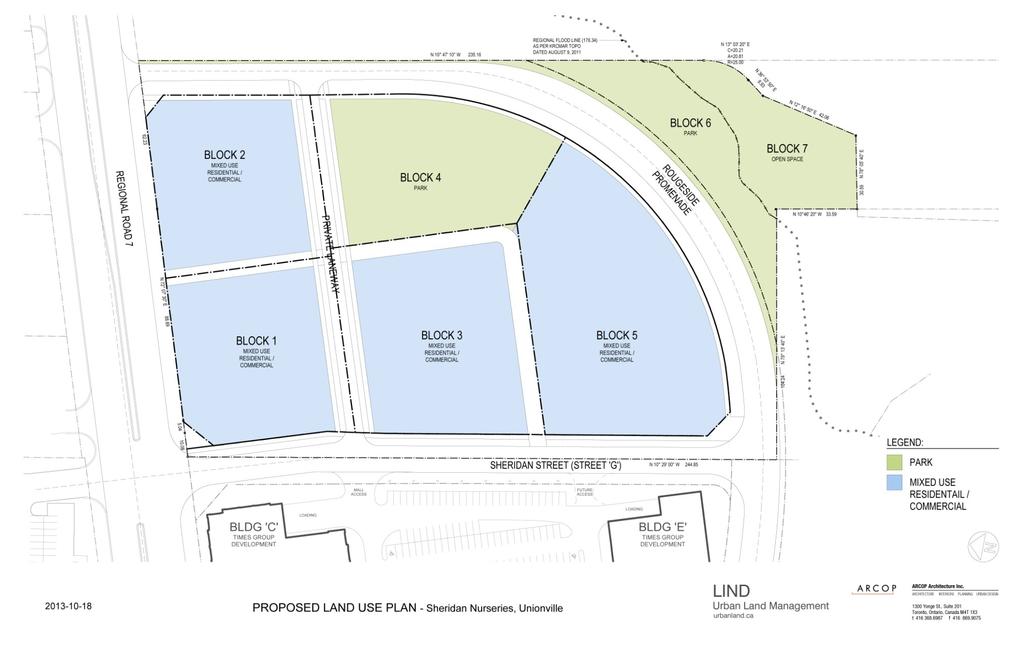
10 4.0 THE SHERIDAN PRECINCT PLAN It is the intention here to show how this Precinct Plan has been developed and crafted to maintain the principles established in the Markham Centre Secondary Plan approved by the Town of Markham in 1994 and finally approved by the OMB in 1997; the more recently adopted Markham Centre North Precinct Plan prepared by Times Group (2009); and the most recently proposed City Official Plan, not yet adopted by Council. Although Sheridan, unlike Times, is not proposing to develop these lands; it was deemed prudent to prepare exhaustive plans and studies to support a Draft Plan of Subdivision and Rezoning in order that the development could be properly analyzed within the context of the rapidly growing Markham Centre and that the appropriate blocks, massing, density ranges, streets, parklands and open space could be determined well in advance of any possible relocation of the Sheridan operation. Note: for illustrative purposes only 10

11 The configuration of streets, blocks and built-form have been designed to ensure that all future development within the precinct plays a pivotal role in shaping a strong public realm. All future buildings will front on a public street and internal streets and driveways are proposed to be designed to appear and function as public rights-of-way ensuring a strong internal public realm. In addition, the site will see the delivery of a new 1.0 acre public park on its east boundary that will be framed and activated by built-form. The plan likewise encourages the development of private outdoor amenity spaces including a mid-block north/south pedestrian mall connecting from Highway No. 7 as well as smaller open spaces associated with residential developments. Note: for illustrative purposes only 11
; and the most recently proposed City Official")
12 5.0 MOVEMENT It is the intention here to show how this Precinct Plan has been developed and crafted to maintain the principles established in the Markham Centre Secondary Plan approved by the Town of Markham in 1994 and finally approved by the OMB in 1997; the more recently adopted Markham Centre North Precinct Plan prepared by Times Group (2009); and the most recently proposed City Official Plan, not yet adopted by Council. 12

13 5.1 Connectivity Given that the Sheridan lands are adjacent to the easterly-most block within the Centre North precinct, it benefits directly from pedestrian and vehicular connectivity to Unionville, Highway No. 7 as well as the network of streets, lanes and open spaces within the Centre North precinct as a whole. The block is within less than a 15-minute walk of Birchmount Road, the GO station across the Rouge Valley and the retail and office uses directly to the west. In this regard, the Sheridan lands will offer a unique and highly liveable addition to the Centre North neighbourhood. 13

14 5.2 Street Hierarchy and Character The Centre North Precinct Plan is comprised of a network of Arterial, Collector and Local streets designed to enhance connectivity across the plan. The Sheridan lands site has been structured so as to reinforce this network of streets. The Sheridan site will front on Highway 7 to the north (arterial), Rougeside Promenade to the south and east (collector) as well as Street 'G' to the west (also a collector). 14


15 Streetscape character within the Centre North Precinct and, by extension, within the Sheridan Precinct plan will be determined by the City of Markham Streetscape Guidelines for Markham Centre. These guidelines establish boulevard character based on a streetscape hierarchy that includes bronze, silver and gold standards. The only exception to this will be the design of the north/south internal private drive which is being considered as a 'pedestrian first' zone with a high level of landscape finish to reinforce its potential as an extension of the mid-block pedestrian mall extending south from Highway No. 7. Bronze Street Silver Street Gold Street 15

16 5.3 Vehicular Circulation It is worth noting that the final alignment of Rougeside Promenade has yet to be finalized and so the Sheridan lands plan brings forward a flexible alignment that would allow it to either extend directly east along the river, or alternatively swing north to form the easterly boundary of our site. As previously stated, internal private streets will be designed to appear and function as local streets within the plan. 5.4 Pedestrian Movement The network of streets in both the Sheridan Precinct Plan and the Centre North Precinct Plan offer a varied and refined grid of pedestrian walkways connecting built form to retail and commercial uses as well as parks and open spaces within the plan. The Sheridan Precinct Plan benefits in no small measure from its proximity to the Transportation Hub east of the GO rail. The Markham Centre Greenlands Plan proposes an extensive network of trails and boardwalks within the Rouge valley and Sheridan has worked directly with the plan to ensure connectivity to this system as a means of easily accessing the Transportation Hub. 5.5 Bicycle Circulation The network of streets in both the Sheridan Precinct Plan and the Centre North Precinct Plan also offer a varied and refined grid of on and off-road bicycle linkages. The Sheridan Precinct Plan in fact plays a key role in extending the bicycle path system farther east along Rougeside Promenade. This system of bike paths also connects with the proposed park/valley trail system offering both a transportation and recreational system to future residents. It is also worth noting that an extensive network of bike parking stations will be incorporated into all future development within the plan as well as within the parks and opens spaces associated with the plan. Note: for illustrative purposes only 16

17 5.6 Public Transit In addition to the pedestrian circulation routes described above, the Sheridan site will benefit from direct access to on-road transit. The site is within one city-block of the proposed Markham Centre Shuttle Service accessing the GO station and the VIVA system on Enterprise Drive. It will also offer direct access to existing YRT bus service on Highway No

18 5.7 Parking (On-street and Below-grade) On-street parking within and abutting the Sheridan Precinct is encouraged as it provides opportunities for short-term stays while precluding the need for the construction of parking lots. Such parking is to be encouraged where appropriate and without negatively affecting vehicular, pedestrian or bicycle movement. Parking associated with development blocks within the plan will be accommodated within buildings. Small amounts of visitor parking may be provided at grade but the majority would be screened from view with underground access. Built-form is arranged on each block in order to ensure that access to underground parking, as well as service access is located off of the internal road network, and placed away from main streets as well as views from intersecting streets. Access is also to be sited so as not to impact upon major public open space areas. 5.8 Building Service Access Waste management storage and its removal should from an integral part of the design process in the layout and articulation of a development s ground floor. Storage of all collected waste and recyclables should be internalized within the building and discretely located away from main building accesses and active frontages. Vehicular movement for waste/recycling pick-up should be configured such as not to impact upon public or private open spaces or residential enjoyment of these spaces. Passenger pick-up and drop-off should be readily accessible from main building entrances and designed in a manner that is accessible to all and does not conflict with pedestrian movement between entrance and public rights-of-way or park spaces. Where possible, areas for pick-up and drop-off should be treated with high quality materials and be clearly demarcated in order to articulate the primary arrivals space of a development. Note: for illustrative purposes only 18
19 6.0 LAND USE In keeping with the proposed Draft Official Plan, it is intended that these lands be developed as Mixed Use within the ' Intensification Area' of Markham Centre. These areas are intended to provide retail and service functions for large populations intermixed with high intensity residential uses. Building types could include residential apartment buildings; multi-storey non-residential or mixed use buildings; stacked townhouses or townhouses.the majority of the site is proposed as ' Mixed Use High Rise'. Within Markham, these areas are meant to accept the highest levels of intensification. A narrow strip along Highway 7 is proposed to be designated Mixed Use Mid-Rise. This designation permits the same range of commercial and residential uses, but with lower heights and a maximum density of approximately 3.0. Buildings in the Mixed Use High Rise category are to have minimum heights of 4 storeys. This precinct plan anticipates that there will be a degree of flexibility with respect to the location of commercial office, retail and personal service uses mixed throughout the blocks with residential such that neighbourhoods will be created where people can shop, live and work within close proximity to local public transportation. 19
20 20


21 7.0 OPEN SPACE 7.1 Connectivity Open space within the Sheridan Precinct will serve to link adjacent open space components and form part of a larger network that encourages public movement and use while also enhancing and protecting existing natural features. It is to include a range of typologies that contribute to an enhanced experience for pedestrians and cyclists. 7.2 Typology and Character The configuration of streets, blocks and built-form have been designed to ensure that all future development within the precinct plays a pivotal role in shaping a strong public realm. All future buildings will front onto a public street and internal streets and driveways are proposed to be designed to appear and function as public rightsof-way ensuring a strong internal public realm. In addition, the site will see the delivery of a new 1.0-acre public park on its east boundary that will be framed and activated by built-form. The plan likewise encourages the development of private outdoor amenity spaces including a mid-block north/south pedestrian mall connecting from Highway No. 7 as well as smaller open spaces associated with residential developments. The Sheridan Precinct Plan is structured around a new 1.0 acre public park located mid-block on the east boundary. The park is surrounded by built-form and offers opportunities for both active and passive recreation. The park enjoys a prominent location and balances the overall distribution of parks within the Centre North Precinct. 21

22 In addition to the public park, the Sheridan precinct will convey privately owned valleylands as well as a small adjoining park block to the City of Markham for inclusion in the Markham Greenlands Plan. This conveyance will allow for the extension of the bicycle/footpath system associated with the Greenlands Plan as well as the restoration of a small piece of degraded landscaping above the top of bank. The valley and associated top of bank have been staked and agreed to by the TRCA and will play an important role in extending the public open space system to the east. 7.3 Views and Vistas Every opportunity has been taken to use buildings not only as a means of framing streets and public spaces but also as a way to create attractive views and vistas. Besides creating important visual relief these vistas can also provide a useful means of way finding especially for visitors to an unfamiliar environment. Looking south from the mid-block break along Highway 7 there is an unobstructed tree lined view terminating in the proposed landmark tower on Rougeside Promenade. The internal east/west access road offers a vista of the public park from Street G where there is an opportunity for terminating this view with appropriately scaled public art in the park. In lower buildings, residential units not facing streets or the park will be given views overlooking landscaped courtyards or amenity spaces situated on a green roof. The mid block tower will have views of the public park to the east and will be buffered from the mall parking lot to the west by a landscaped courtyard. A majority of units in the two south towers and the podium will have unobstructed south facing views over the Rouge valley. 22


23 7.4 Public Art The geometry of the Sheridan Precinct offers a multitude of opportunities for the incorporation of public art. A strong linear grid of streets and drives as well as views anchored on the public park and prominent built-form should all be viewed as opportunities for public art. In this instance art can be used to animate views and draw people into the site. It could also be used to convey the history of this site. Note: for illustrative purposes only 23
24 8.0 BUILT-FORM 8.1 Massing Building massing extends the general pattern of development established to the east in the Markham Centre North Precinct with six to eight storey buildings located along Highway 7 and taller point towers to the south overlooking the proposed park and the Rouge valley. Taller buildings are each set on a lower podium providing opportunities for appropriately scaled facades at street level. Blocks 1, 2, 3 and 5 as shown on the conceptual block plan present opportunities for a range of commercial and residential development which will be further articulated in subsequent site planning. It is expected that there may be opportunities for ground floor retail along Rougeside Promenade; especially for uses such as cafes, restaurants and personal services which could take advantage of the pedestrian traffic near the valley edge trails, links to the GO station and vehicular traffic drawn along this route. The two parcels fronting on Highway 7 allow for either a continuation of the six storey street wall west of the mall or a break in this pattern. The proposed massing shows a break with some setbacks to provide a landscaped courtyard and a lower podium structure with a green roof. This option as illustrated would offer north facing residential units some separation from Highway 7 and an alternative foreground view when facing this busy arterial. 24
25 All towers are proposed as slender point blocks with floor plate areas consistent with development to the west. The illustrated configurations are necessarily schematic and the central round tower is intended to convey the idea that this prominent location on Rougeside Promenade warrants a landmark structure with distinctive architecture. It also marks that point in Markham Centre North that is in closest proximity to the Mobility Centre and the proposed pedestrian and bicycle link to the Centre. In this location height and density will be situated conveniently close to public transit. It is intended that private laneways for vehicular and/or pedestrian traffic internal to the site will be subject to an easement in favour of the City for public access and that these details will be addressed as future site plans are finalized." 8.2 Height and Densities In keeping with the proposed new Official Plan, which calls for densities in this area of Intensification and for lands designated Mixed Use High Rise, development may have a density generally in the range of 2.5 to 3.5 FSI. This site is proposed to conform to this objective. While heights are generally consistent with development to the east some increase has been proposed to allow for the creation of a significant public park. It was also considered important to introduce some variety in tower heights with the aforementioned landmark building being the tallest of the three towers. Lower slab form structures are arranged to frame streets and public spaces and are restricted to six and eight storeys. The eight storey buildings are stepped back above the sixth storey level along streets in order to introduce a consistent pedestrian scale along these frontages. 25


26 8.3 Character of Development New development within the Sheridan Precinct will present a consistent identity, one that distinguishes itself from that of adjacent properties while also being associated with surrounding new development by means of height and massing. The building character will contribute to a high quality public realm while also respecting the guidelines in Section 3.0 Sustainability as noted in this document. 26
27 9.0 SERVICING and DEVELOPMENT PHASING 9.1 Limit of Development The limit of development was established based on; i) the north limit of the recently constructed stormwater management facility (Sheridan SWM Pond) and ii) the greater of the Regional Storm Flood line or Physical Top of Bank (as staked with TRCA), plus a 10 m buffer. In accordance with OPA 21, the parkland adjacent to the Rouge River valley may include the 10 m buffer. 9.2 Municipal Servicing and Sustainability Measures SCS Consulting Group was retained to prepare the Functional Servicing Report (FSR) and Preliminary Stormwater Management Report to support the Draft Plan of Subdivision. The City of Markham recently designed a trunk sanitary sewer along Highway 7 from the York Durham Sanitary System at Kennedy Road, which was sized to accommodate the subject lands. The sewer was constructed in The study area will be serviced via local gravity collector sewers in a generally south to north direction, to the proposed Highway 7 trunk sanitary sewer at Street G (which abuts the west property limit of the site). Servicing allocation will be subject to Markham Council approval. There is an approximate 2.6 ha external area to the east of the site that can either; i) have sanitary drainage conveyed through the site via local sanitary sewers on Rougeside Promenade and Street G, or ii) have sanitary drainage conveyed easterly to another existing connection point to the Highway 7 trunk sanitary sewer at the future Sciberras Road. The study area is entirely located within water Pressure District 5. The site will be serviced through a connection to a proposed 200 mm diameter watermain on Street G, which connects to the recently constructed 300 mm diameter watermain on Highway 7. A looped network of watermains will be located through the site. There is a recently constructed stormwater management facility (Sheridan SWM Pond) located at the south limit of the property that will treat storm runoff from the site and other lands south of Highway 7, as well as lands north of Highway 7. 27
28 In accordance with the Master Servicing and Drainage Plan (MSDP) prepared for the Markham Avenue 7 Landowners Group by SCS Consulting Group Ltd. (September 2011), stormwater management measures for the site will include quality control (Enhanced Level), erosion control (attenuation of the 25 mm rainfall runoff with 24 hr release) and water balance enhancement (retain 5 mm rainfall event volume on-site). Stormwater quantity control is not required for lands draining directly to the Rouge River. In accordance with the MSDP, runoff from 85% of the site plan shall be managed on-site for quality control treatment prior to discharging to the municipal storm sewer system. The remaining 15% of the site plan will runoff directly to the municipal storm sewer system and be treated by the existing Sheridan SWM Pond, together with the runoff from the municipal road right-of-ways. A gravity storm sewer system will collect 5 year runoff from the site and convey it to the existing Sheridan SWM Pond (via the north inlet headwall). Storm drainage from the future development lands east of the site area will be drained by others via a future storm sewer along the extension of Rougeside Promenade east of the site. The storm sewer on Rougeside Promenade within the site will be sized to convey these future flows to the existing Sheridan SWM Pond (via the north inlet headwall). Quality control is proposed to be provided using a treatment train approach of LID measures including increased topsoil depths, passive landscaping, grassed swales, green roofs, rainwater harvesting for on-site re-use, oil-grit separators, and an end-of-pipe wet pond (the existing Sheridan SWM Pond). The site plan block will provide on-site quality control for the parking lot and landscaped areas via an oil-grit separator sized to provide Enhanced level of protection (80% TSS removal) prior to outletting to the municipal storm sewer system. Rooftop runoff will by-pass the oil-grit separator. Runoff from municipal road right-of-ways will have quality control provided for in the existing downstream Sheridan SWM Pond. Erosion control for the entire site area will be provided in the existing downstream Sheridan SWM Pond. Green roof and adjacent sloped roofs are proposed to drain to cisterns to allow stormwater re-use for irrigation. Landscaped areas are proposed to utilize rain gardens where appropriate. These additional detention methods will be in addition to the erosion control storage noted above. Water balance enhancement will be provided by retaining the equivalent of the 5 mm rainfall event volume at the site plan level on-site via a combination of LID techniques such as rainwater harvesting for irrigation, rain gardens, extra topsoil depths, etc. The green roof areas are assumed to fully absorb the 5 mm rainfall runoff directly falling on the roof area. 28
29 9.3 Transportation BA Consulting Group Ltd was retained by Sheridan Nurseries Unionville to carry out a transportation impact study (TIS) to support the Draft Plan of Subdivision. In keeping with The Markham Centre Secondary Plan (OPA 21), priority has been given to transit, pedestrians and cyclists, as well as other measures that reduce auto dependency and minimize single occupant vehicle (SOV) travel. This approach is consistent with the Markham Centre Transportation Study (draft November 2009), Pedestrian and Cycling Master Plan (2008), Draft Cycling and Pathways & Trails Master Plans (2007), Markham s 2002 Transportation Planning Study (MTPS) and York Region s Transportation Master Plan (2002). In order to ensure that the transportation needs of people travelling to, from and within Sheridan Development are met, a significant focus has been placed on sustainable transportation which refers to a range of initiatives aimed at reducing single-occupant vehicle (SOV) trips. The Transportation system servicing the Sheridan Development Sheridan Development would support this objective through the provision pedestrian friendly street pattern, and the provision of bicycle routes and facilities. The Sheridan Development will provide for the easterly extension of Rougeside Promenade, a minor east-west collector road, and accommodates the introduction of two new north-south public streets along the east and west limits of the site. The new public streets form part of larger internal road network that will serve the Markham Centre community. The new internal roads are capable of generating sufficient accessibility and capacity to satisfactorily serve the anticipated vehicle demands. Each roadway will be designed for all users: pedestrians, cyclists, transit users, and motor vehicles. As development proceeds in Markham Centre, north/south links will be added by connecting to Verclaire Gate and to Village Parkway at Highway 7. The connection of Birchmount Road to Village Parkway is expected to be completed within the next two years. This will provide the Sheridan Development and the Markham Centre community with a direct connection south to the City of Toronto. The completion of Rougeside Promenade to Sciberras Road and the southerly extension of Sciberras Road to Enterprise Way are also planned. The Sheridan Development is located within a kilometre from the Unionville Station on GO transit s Union Stouffville Line. Several GO Transit buses, VIVA buses and York Region Transit (YRT) buses operate to and from this Station and provide connections to other areas of the City as well as other GTA communities. As such, the site is well served by extensive transit routes and facilities within the immediate vicinity. 29
30 According to the Draft Markham Centre Transportation Study, 23% of weekday morning rush hour trips from Markham Centre are made by sustainable modes, transit, walk, cycle, auto passenger), up from 11% in Transit ridership is therefore increasing to projected levels. 9.4 Development Phasing The site could be built either in a single phase, or in several phases. The sanitary sewer and watermain connections on Street G, as well as the storm sewer connection to the existing Sheridan SWM Pond north inlet headwall will be required in support of the initial development phase. The phasing of the construction of Street G, Rougeside Promenade and the internal laneways will be dependent on the phasing of the site development. 30
31 Draft Plan of Subdivision
URBAN DESIGN BRIEF URBAN DESIGN BRIEF 721 FRANKLIN BLVD, CAMBRIDGE August 2018
 URBAN DESIGN BRIEF URBAN DESIGN BRIEF 721 FRANKLIN BLVD, CAMBRIDGE August 2018 DESIGN BRIEF CONTENTS PART A 1.0 INTRODUCTION 2.0 DESCRIPTION & ANALYSIS OF SITE CONTEXT 3.0 DESIGN CONSTRAINTS AND OPPORTUNITIES
DRAFT Northeast Quadrant of Kipling Avenue and Highway 7 DRAFT AUGUST 29, Goals Land Use. The goals of this Plan are to:
 AUGUST 29, 2017 12.15 Northeast Quadrant of Kipling Avenue and Highway 7 12.15.1 Goals 12.15.2 Land Use The goals of this Plan are to: 12.15.2.1 General Provisions: a) Ensure the development of a compact
ELMVALE ACRES SHOPPING CENTRE MASTER PLAN
 ELMVALE ACRES SHOPPING CENTRE MASTER PLAN Contents 1.0 INTRODUCTION... 2 2.0 LOCATION... 2 3.0 EXISTING CONTEXT... 2 4.0 VISION & GUIDING PRINCIPLES... 2 5.0 LAND USE AND BUILT FORM... 4 5.1 St. Laurent
Clairtrell Area Context Plan
 Clairtrell Area Context Plan March 2005 Urban Development Services City Planning Contents 1. Introduction... 4 2. Development Structure... 6 2.1 Streets... 7 2.1.1 Sheppard Avenue and Bayview Avenue...
URBAN DESIGN BRIEF. 2136&2148 Trafalgar Road. Town of Oakville
 URBAN DESIGN BRIEF 2136&2148 Trafalgar Road Town of Oakville Prepared By: METROPOLITAN CONSULTING INC For 2500674 Ontario Inc November 2016 TABLE OF CONTENTS Page No. 1.0 Introduction/Description of Subject
CONTENTS 8.0 LAND USE 8.1 GENERAL LAND USE 8.2 RESIDENTIAL 8.3 MIXED USE 8.4 COMMERCIAL 8.5 EMPLOYMENT LANDS
 8-2 Land Use 8.0 LAND USE CONTENTS 8.1 GENERAL LAND USE 8.1.1 Uses provided for in all Land Use Designations 8.1.2 Uses prohibited in Hazardous Lands, Hazardous Sites and Special Policy Areas 8.1.3 Uses
Derry Green Corporate Business Park
 Town of Milton Derry Green Corporate Business Park Urban Design Guidelines BMI/Pace - June 2010 Draft 3 Prepared by: Brook McIlroy Planning + Urban Design / Pace Architects Suite 300-51 Camden Street Toronto,
Regency Developments. Urban Design Brief. Holyrood DC2 Rezoning
 Regency Developments Urban Design Brief Holyrood DC2 Rezoning Stantec Consulting Ltd. 7-31-2017 1. Overview Regency Developments intends to rezone the lands located at 8510 and 8511 93 Avenue, within the
McCowan Precinct Plan Study Background & Deliverables
 1 DRAFT & WITHOUT PREJUDICE McCowan Precinct Plan Study Background & Deliverables In September, 2011, City Planning (Scarborough District) began a study of an area within the Scarborough Centre, identified
The West Vaughan Employment Area Secondary Plan Policies
 Part 2: The West Vaughan Employment Area Secondary Plan Policies 2.1 General Policies It is the policy of Council: 2.1.1. That the West Vaughan Employment Area (the WVEA), identified on Schedule 1, will
YONGE STEELES CORRIDOR SECONDARY PLAN. Young + Wright / IBI Group Architects Dillon Consulting Ltd. GHK International (Canada) Ltd.
 Ltd.") PART A: PREAMBLE 1.0 PURPOSE The purpose of this Secondary Plan is to provide a development framework for intensification of the Yonge/ Steeles corridor including the north side of Steeles Avenue West
PART A: PREAMBLE 1.0 PURPOSE The purpose of this Secondary Plan is to provide a development framework for intensification of the Yonge/ Steeles corridor including the north side of Steeles Avenue West
PORT WHITBY COMMUNITY
 PORT WHITBY COMMUNITY SECONDARY PLAN UPDATE COMMUNITY IMPROVEMENT PLAN URBAN DESIGN GUIDELINES September 2015 DRAFT PROPOSED AMENDMENT NUMBER # to the Whitby Official Plan PURPOSE: The intent of this Amendment
North Oakville East Parks Facilities Distribution Plan. November, 2009
 North Oakville East November, 2009 POLICY CONTEXT 1) Purpose a) The purpose of this document is to be a guide for the location, configuration, design and development of the parks system for the North Oakville
Uptown Rideau Street Secondary Plan [Amendment #166, January 12, 2016]
![Uptown Rideau Street Secondary Plan [Amendment #166, January 12, 2016]](/thumbs/76/73760497.jpg "Uptown Rideau Street Secondary Plan [Amendment #166, January 12, 2016]") [Amendment #166, January 12, 2016] The policies of this Secondary Plan are in effect, save and except for the property at 560 Rideau Street, for which there remains a site specific appeal to this Secondary
[Amendment #166, January 12, 2016] The policies of this Secondary Plan are in effect, save and except for the property at 560 Rideau Street, for which there remains a site specific appeal to this Secondary
THE CITY OF VAUGHAN BY-LAW BY-LAW NUMBER A By-law to adopt Amendment Number 1 to the Official Plan of the Vaughan Planning Area.
 THE CITY OF VAUGHAN BY-LAW BY-LAW NUMBER 015-2014 A By-law to adopt Amendment Number 1 to the Official Plan of the Vaughan Planning Area. NOW THEREFORE the Council of the Corporation of the City of Vaughan
CONTENTS 6.1 URBAN DESIGN
 6-2 Urban Design and Sustainable Development 6.0 URBAN DESIGN AND SUSTAINABLE DEVELOPMENT CONTENTS 6.1 URBAN DESIGN 6.1.1 General Policies 6.1.2 The Public Realm 6.1.3 Streets and Blocks 6.1.4 Streetscapes
Urban Design Brief. Watson Parkway North & Watson Road North Guelph, Ontario. Prepared by Coletara Development
 Urban Design Brief Watson Parkway North & Watson Road North Guelph, Ontario Prepared by Coletara Development December, 2013 Urban Design Brief, Coletara Development 1 Introduction This Urban Design Brief
SQUAMISH 2010 AND BEYOND COMMUNITY VISION
 Our plan has been imagined and created to be both pragmatic and visionary. At the core of the strategy is a consideration of the highway s role and its impact on the community. First and foremost in creating
OFFICE CONSOLIDATION SECONDARY PLAN AREA 22 THE BRAMALEA SOUTH INDUSTRIAL SECONDARY PLAN
 OFFICE CONSOLIDATION SECONDARY PLAN AREA 22 THE BRAMALEA SOUTH INDUSTRIAL SECONDARY PLAN November 2010 EXPLANATORY NOTES (Secondary Plan Area 22) General (pertaining to all secondary plan office consolidations)
CITY OF VAUGHAN D R A F T YONGE STREET STUDY. June 2008 YOUNG + WRIGHT /IBI GROUP ARCHITECTS DILLON CONSULTING LTD.
 CITY OF VAUGHAN June 2008 YOUNG + WRIGHT /IBI GROUP ARCHITECTS GHK SUSTAINABILITY INTERNATIONAL + LIVABILITY (CANADA) LTD. = COMMUNITY VALUE DILLON CONSULTING LTD. Public Open House Tonight s Meeting WELCOME
Urban Design Brief December 23, 2015 Southside Construction Group Official Plan & Zoning By-Law Amendment
 Urban Design Brief Proposed Official Plan & Zoning By-Law Amendment 3244, 3263 and 3274 Wonderland Road South Southside Group December 23, 2015 TABLE OF CONTENTS Page No. INTRODUCTION... 1 SECTION 1 LAND
Official Plan Review: Draft Built Form Policies
 PG.30.1 REPORT FOR ACTION Official Plan Review: Draft Built Form Policies Date: May 15, 2018 To: Planning and Growth Management Committee From: Chief Planner and Executive Director, City Planning Division
Complete Neighbourhood Guidelines Review Tool
 Complete Neighbourhood Guidelines Review Tool Prepared By: City of Regina Planning Department October 2014 Page 1 of 14 Community Development Review Checklist for Secondary Plans and Concept Plans The
East Bayshore Road Neighbourhood
 East Bayshore Road Neighbourhood Northridge Property Management Urban Design Brief 3195 East Bayshore Road City of Owen Sound January 2016 East Bayshore Road Neighbourhood Northridge Property Management
Transportation. Strategies for Action
 Transportation A major priority for the Overlake Neighborhood is to develop a multimodal transportation system. To achieve this system, a balance has to be found among travel, circulation and access needs;
URBAN DESIGN BRIEF. Saginaw Subdivision 124 SAGINAW PARKWAY, CAMBRIDGE OCTOBER 2015 OUR FILE 1422A
 URBAN DESIGN BRIEF Saginaw Subdivision 124 SAGINAW PARKWAY, CAMBRIDGE OCTOBER 2015 OUR FILE 1422A Contents 1.0 INTRODUCTION AND SITE DESCRIPTION... 1 2.0 MUNICIPAL DESIGN DIRECTION... 7 3.0 MASTER CONCEPT
Westwind Developments Ltd. PIONEER LANDS AREA STRUCTURE PLAN - PROPOSED AMENDMENT
 FEBRUARY 2013 TABLE OF CONTENTS 1.0 BACKGROUND... 1 1.1 Amendment... 1 2.0 LOCATION & CONTEXT... 2 2.1 Land Ownership... 2 3.0 POLICY CONTEXT... 3 3.1 Municipal Development Plan... 3 3.2 Capital Region
New-Cast Mixed-use Development Proposal King Street West, Newcastle, Ontario
 URBAN DESIGN BRIEF New-Cast Mixed-use Development Proposal King Street West, Newcastle, Ontario TABLE OF CONTENTS: 1.0 Executive Summary 2.0 Creating Vibrant and Sustainable Urban Places: Excerpts from
4.1.3 LAND USE CATEGORIES
 4.1.3 LAND USE CATEGORIES a. City Center District The City Center District incorporates the existing character and mix of uses in downtown Belmont to encourage redevelopment and new development in keeping
11.5 Kipling Avenue Corridor Secondary Plan
 11.5 Kipling Avenue Corridor Secondary Plan ADOPTED BY VAUGHAN CITY COUNCIL NOT YET APPROVED BY THE ONTARIO MUNICIPAL BOARD 11.5.1 Development Principles and Objectives The following principles support
BESSARION-LESLIE CONTEXT PLAN
 Development in the Bessarion-Leslie area will be consistent with the following urban design guidelines. They provide a framework for development in the area and are to be read in conjunction with the urban
*** DRAFT 2 FOR PUBLIC REVIEW ***
 6.7 The area is generally bounded by the Red Hill Valley Parkway to the west, Lake Avenue to the east, the Queen Elizabeth Way (QEW) to the north, and by the properties just south of Queenston Road to
URBAN DESIGN BRIEF Gordon Street City of Guelph. Prepared on behalf of Ontario Inc. March 25, Project No. 1507
 URBAN DESIGN BRIEF 1131 Gordon Street City of Guelph Prepared on behalf of 1876698 Ontario Inc. March 25, 2016 Project No. 1507 423 Woolwich Street, Suite 201, Guelph, Ontario, N1H 3X3 Phone (519) 836-7526
13 THORNHILL YONGE STREET STUDY IMPLEMENTATION CITY OF VAUGHAN OPA 669 AND TOWN OF MARKHAM OPA 154
 13 THORNHILL YONGE STREET STUDY IMPLEMENTATION CITY OF VAUGHAN OPA 669 AND TOWN OF MARKHAM OPA 154 The Planning and Economic Development Committee recommends the adoption of the recommendations contained
Mark-up of the effect of the proposed Bronte Village Growth Area OPA No.18 on the text of section 24, Bronte Village, of the Livable Oakville Plan
 Mark-up of the effect of the proposed Bronte Village Growth Area OPA No.18 on the text of section 24, Bronte Village, of the Livable Oakville Plan Notes: This document is provided for information purposes
Urban Design Manual PLANNING AROUND RAPID TRANSIT STATIONS (PARTS) Introduction. Station Study Areas
 Introduction. Station Study Areas") 111111 PLANNING AROUND RAPID TRANSIT STATIONS (PARTS) Introduction The ION rapid transit system will link Waterloo, Kitchener and Cambridge through a central transit corridor (CTC). There are a number
111111 PLANNING AROUND RAPID TRANSIT STATIONS (PARTS) Introduction The ION rapid transit system will link Waterloo, Kitchener and Cambridge through a central transit corridor (CTC). There are a number
DAVENPORT VILLAGE SECONDARY PLAN
 27 DAVENPORT VILLAGE SECONDARY PLAN 27. DAVENPORT VILLAGE SECONDARY PLAN 1. VISION FOR THE DAVENPORT VILLAGE SECONDARY PLAN Davenport Village, municipally known as 830, 940, 980 and 1100 Lansdowne Avenue,
5 TOWN OF MARKHAM OFFICIAL PLAN AMENDMENT NO. 144 MILLIKEN MAIN STREET SECONDARY PLAN
 5 TOWN OF MARKHAM OFFICIAL PLAN AMENDMENT NO. 144 MILLIKEN MAIN STREET SECONDARY PLAN The Planning and Economic Development Committee recommends the following: 1. The communication from Brendan O Callaghan,
Report to: Development Services Committee Report Date: April 24, 2017
 SUBJECT: Cornell Rouge National Urban Park Gateway - Report on Design Charrette and Next Steps PREPARED BY: Lilli Duoba, MES, MCIP, RPP, Manager, Natural Heritage (ext. 7925) REVIEWED BY: Marg Wouters,
Welcome. Walk Around. Talk to Us. Write Down Your Comments
 Welcome This is an information meeting introducing the applications for proposed redevelopment of the Yorkdale Shopping Centre site at 3401 Dufferin Street and 1 Yorkdale Road over the next 20+ years,
CHAPTER 5: GUIDING PRINCIPLES
 CHAPTER 5: GUIDING PRINCIPLES The following 10 principles were developed based on public consultation, planning policy and the background analysis conducted during Phase 1. The Guiding Principles significantly
599 Kennedy Road - Official Plan Amendment and Zoning Amendment Application - Preliminary Report
 STAFF REPORT ACTION REQUIRED 599 Kennedy Road - Official Plan Amendment and Zoning Amendment Application - Preliminary Report Date: March 7, 2017 To: From: Wards: Reference Number: Scarborough Community
FORMER CANADIAN FORCES BASE (CFB) ROCKCLIFFE SECONDARY PLAN. Official Plan Amendment XX to the Official Plan for the City of Ottawa
 ROCKCLIFFE SECONDARY PLAN. Official Plan Amendment XX to the Official Plan for the City of Ottawa") FORMER CANADIAN FORCES BASE (CFB) ROCKCLIFFE SECONDARY PLAN Official Plan Amendment XX to the Official Plan for the City of Ottawa 1 INDEX THE STATEMENT OF COMPONENTS PART A THE PREAMBLE PAGE Purpose...
FORMER CANADIAN FORCES BASE (CFB) ROCKCLIFFE SECONDARY PLAN Official Plan Amendment XX to the Official Plan for the City of Ottawa 1 INDEX THE STATEMENT OF COMPONENTS PART A THE PREAMBLE PAGE Purpose...
5.1 Site Plan Guidelines
 5. Community Core Guidelines Development of the Community Core will take place by plan of subdivision and site plan approval. It will occur in a phased manner that will reflect the timing of residential
ONTARIO MUNICIPAL BOARD
 PL 120483 ONTARIO MUNICIPAL BOARD Applicant/Appellant: 2124123 Ontario Limited Subject: OPA, Rezoning and Draft Plan of Subdivision Municipal Address: 3940 Highway 7 East Municipality: City of Markham
1296 Kennedy Road - Zoning Amendment Application - Preliminary Report
 STAFF REPORT ACTION REQUIRED 1296 Kennedy Road - Zoning Amendment Application - Preliminary Report Date: January 15, 2016 To: From: Wards: Reference Number: Scarborough Community Council Acting Director,
DOWNTOWN GEORGETOWN PLANNING STUDY
 DOWNTOWN GEORGETOWN PLANNING STUDY Community Workshop #3 Thursday, May 4, 08 The Planning Partnership OVERVIEW OF STUDY, PROCESS & MILESTONES We are here PURPOSE OF THE STUDY To develop a clear vision
PROPOSED REDEVELOPMENT OF THE GLEN ABBEY GOLF CLUB. STREETSCAPE DESIGN STUDY (excerpt from the Urban Design Brief) TOWN OF OAKVILLE.
 TOWN OF OAKVILLE.") PROPOSED REDEVELOPMENT OF THE GLEN ABBEY GOLF CLUB STREETSCAPE DESIGN STUDY (excerpt from the Urban Design Brief) TOWN OF OAKVILLE OCTOBER, 2016 for 2.4.2 STREETS Streets are the single largest component
PROPOSED REDEVELOPMENT OF THE GLEN ABBEY GOLF CLUB STREETSCAPE DESIGN STUDY (excerpt from the Urban Design Brief) TOWN OF OAKVILLE OCTOBER, 2016 for 2.4.2 STREETS Streets are the single largest component
ARTICLE 6: Special and Planned Development Districts
 ARTICLE 6: Special and Planned Development Districts 6-10 Traditional Neighborhood Development (TND) District 6-10.10 Purpose and Intent The Traditional Neighborhood Development (TND) District provides
Workshop 3. City of Burlington Waterfront Hotel Planning Study. September 14, The Planning Partnership
 Workshop 3 City of Burlington Waterfront Hotel Planning Study September 14, 2017 The Planning Partnership The Waterfront Hotel Planning Study 01 The Brant & Lakeshore Planning Study will establish a Strategic
Midtown Oakville will be a vibrant, transit-supportive, mixed use urban community and employment area.
 Livable Oakville Part E: Growth Areas, Special Policy Areas and Exceptions 20. MIDTOWN OAKVILLE 20.1 Goal The interchange of Trafalgar Road and the QEW and the Oakville GO Station are major entry points
This Review Is Divided Into Two Phases:
 Semiahmoo Town Centre Review The purpose of this review: To review the Semiahmoo Town Centre Concept Plan, originally approved in 1993, to ensure that this centre will continue to serve the needs of South
Bank Street Secondary Plan
 1.1 Introduction The is a guide to the long term design and development of the portion of Bank Street between Riverside Drive and Ledbury Park, and provides direction on land use, built form, design, parking,
DRAFT DRAFT DRAFT DRAFT
 # 19 EXPAND GREEN AND OPEN SPACES AND COMMUNITY FACILITIES IN TANDEM WITH NEW DEVELOPMENT The role of Eglinton will change in the coming years, along with the intensity of activity and land uses. As more
(DC1) Direct Development Control Provision DC1 Area 4
 Direct Development Control Provision DC1 Area 4") . General Purpose (DC) Direct Development Control Provision DC Area 4 The purpose of this Provision is to provide for an area of commercial office employment and residential development in support of the
. General Purpose (DC) Direct Development Control Provision DC Area 4 The purpose of this Provision is to provide for an area of commercial office employment and residential development in support of the
4780 Eglinton Avenue West - Zoning By-law Amendment and Draft Plan of Subdivision Applications - Preliminary Report
 STAFF REPORT ACTION REQUIRED 4780 Eglinton Avenue West - Zoning By-law Amendment and Draft Plan of Subdivision Applications - Preliminary Report Date: May 29, 2014 To: From: Wards: Reference Number: Etobicoke
URBAN DESIGN BRIEF 181 Burloak Drive, Oakville
 URBAN DESIGN BRIEF 181 Burloak Drive, Oakville February 2017 Our File: 1730B 230-7050 WESTON ROAD / WOODBRIDGE / ONTARIO / L4L 8G7 / T: 905 761 5588/ F: 905 761 5589/WWW.MHBCPLAN.COM TABLE OF CONTENTS
CONTENTS 2.0 A FRAMEWORK FOR SUSTAINABLE GROWTH 2.1 MANAGING SUSTAINABLE GROWTH THE VISION TO GOALS AND OBJECTIVES 2.3 MARKHAM STRUCTURE
 2 A Framework for Sustainable Growth 2.0 A FRAMEWORK FOR SUSTAINABLE GROWTH CONTENTS 2.1 MANAGING SUSTAINABLE GROWTH THE VISION TO 2031 2.2 GOALS AND OBJECTIVES 2.2.1 Protecting the Natural Environment
Bloor St. W. Rezoning - Preliminary Report
 STAFF REPORT ACTION REQUIRED 1638-1644 Bloor St. W. Rezoning - Preliminary Report Date: April 1, 2008 To: From: Wards: Reference Number: Toronto and East York Community Council Acting Director, Community
City of Vaughan Urban Design Guidelines for Infill Development in Established Low-Rise Residential Neighbourhoods
 City of Vaughan Urban Design Guidelines for Infill Development in Established Low-Rise Residential Neighbourhoods DRAFT - September 2016 Contents 1. Introduction 1 2. Policy Context 3 3. Characteristics
178 Carruthers Properties Inc.
 178 Carruthers Properties Inc. Planning Rationale for 178 Carruthers Avenue Site Plan Control Application June 2014 Table of Contents 1.0 Introduction 2.0 Overview of Subject Property 3.0 Current Zoning
BASIC SITE PLAN AND DESIGN PRINCIPLES FOR REDEVELOPMENT OF 114 RICHMOND ROAD
 BASIC SITE PLAN AND DESIGN PRINCIPLES FOR REDEVELOPMENT OF 114 RICHMOND ROAD Department of Planning and Growth Management City of Ottawa August 2009 1. Site Locations and Description The property is located
QUEEN-RIVER SECONDARY PLAN
 34 QUEEN-RIVER SECONDARY PLAN 34. QUEEN RIVER SECONDARY PLAN 1. INTRODUCTION The Queen-River area is approximately 6.4 hectares and is located at the eastern edge of the Downtown as shown on Map 34-1.
Land Use Amendment in Southwood (Ward 11) at and Elbow Drive SW, LOC
 at and Elbow Drive SW, LOC") 2018 November 15 Page 1 of 10 EXECUTIVE SUMMARY This land use amendment application was submitted by Rick Balbi Architect on 2017 August 31 on behalf of Sable Developments Ltd, and with authorization from
2018 November 15 Page 1 of 10 EXECUTIVE SUMMARY This land use amendment application was submitted by Rick Balbi Architect on 2017 August 31 on behalf of Sable Developments Ltd, and with authorization from
INTRODUCTION TO THE CONCEPTUAL SITE PLANS
 INTRODUCTION TO THE CONCEPTUAL SITE PLANS At this stage in the planning process, we are seeking your feedback on the draft Guiding Principles and input in evaluating three conceptual site plans. Each of
14 Community Nodes Introduction. Port Credit; Rathwood-Applewood; There are ten Community Nodes in Mississauga: Sheridan; Clarkson Village;
 14 Community Nodes 14.1 Introduction Port Credit; Rathwood-Applewood; There are ten Community Nodes in Mississauga: Clarkson Village; Dixie-Dundas; Lakeview; Malton; Meadowvale; Sheridan; South Common;
AGINCOURT SECONDARY PLAN
 1 AGINCOURT SECONDARY PLAN 1. AGINCOURT SECONDARY PLAN The following policies and principles apply to the area herein referred to as Agincourt, as outlined on Map 1-1. 1. GENERAL POLICIES 1.1 This Secondary
Yonge Eglinton Centre Urban Design Guidelines
 Yonge Eglinton Centre Urban Design Guidelines City Planning Urban Design January 2009 YONGE EGLINTON CENTRE INTRODUCTION.................................................... 1 GENERAL SITE PLAN OBJECTIVES......................................
Queen Street West - Zoning Amendment Application - Preliminary Report
 STAFF REPORT ACTION REQUIRED 944-952 Queen Street West - Zoning Amendment Application - Preliminary Report Date: February 6, 2013 To: From: Wards: Reference Number: Toronto and East York Community Council
Public Consultation Summary: Lakeview Place Making Workshop January 30, 2008.
 Page 1 of 11 Public Consultation Summary: Lakeview Place Making Workshop January 30, 2008. 1.0 Introduction: On January 30, 2008 the City of Mississauga, in conjunction with the consulting team of Brook
Urban Design Brief Proposed Residential Development 5219 Upper Middle Road City of Burlington
 Urban Design Brief Proposed Residential Development 5219 Upper Middle Road City of Burlington Prepared by Weston Consulting Prepared for BLOOMFIELD DEVELOPMENT INC. Date: March 2017 Table of Contents 1.
Gold Line Bus Rapid Transit Transit Oriented Development (BRTOD) Helmo Station Area Plan
 Helmo Station Area Plan") Appendix F Gold Line Bus Rapid Transit Transit Oriented Development (BRTOD) Helmo Station Area Plan Introduction and Purpose of the Plan The Gold Line Bus Rapid Transit facility is an eleven-mile dedicated
Appendix F Gold Line Bus Rapid Transit Transit Oriented Development (BRTOD) Helmo Station Area Plan Introduction and Purpose of the Plan The Gold Line Bus Rapid Transit facility is an eleven-mile dedicated
New Official Plan Quest November 2013
 City of Markham New Official Plan Quest November 2013 Building Markham s Future Together - 6 Key Strategic Priorities 1. Growth - Managing our Growth 2. Transportation/Transit - Improving transportation
5.0 Community Design Plan
 5.0 Community Design Plan The Community Design Plan for the Mer Bleue area is a composite of three plans: Land Use Plan Transportation Plan Municipal Servicing Plan Read together, these Plans and associated
[PLANNING RATIONALE] For Site Plan Control and Lifting of Holding Zone By-Law 101 Champagne Avenue. May 23, 2014
![[PLANNING RATIONALE] For Site Plan Control and Lifting of Holding Zone By-Law 101 Champagne Avenue. May 23, 2014](/thumbs/75/71599615.jpg "[PLANNING RATIONALE] For Site Plan Control and Lifting of Holding Zone By-Law 101 Champagne Avenue. May 23, 2014") [PLANNING RATIONALE] For Site Plan Control and Lifting of Holding Zone By-Law 101 Champagne Avenue May 23, 2014 Contents 1.0 Introduction... 2 2.0 Site Context... 2 2.1 Adjacent Uses... 2 Figure 1: Site
[PLANNING RATIONALE] For Site Plan Control and Lifting of Holding Zone By-Law 101 Champagne Avenue May 23, 2014 Contents 1.0 Introduction... 2 2.0 Site Context... 2 2.1 Adjacent Uses... 2 Figure 1: Site
2.0 A FRAMEWORK FOR SUSTAINABLE GROWTH CONTENTS
 2-2 A Framework for Sustainable Growth 2.0 A FRAMEWORK FOR SUSTAINABLE GROWTH CONTENTS 2.1 MANAGING SUSTAINABLE GROWTH THE VISION TO 2031 2.2 GOALS AND OBJECTIVES 2.2.1 Protecting the Natural Environment
Corridor Transformation Strategy
 Corridor Transformation Strategy County Road 22 Special Planning Area Design Guidelines January 2012 D14-06017 Corridor Transformation Strategy County Road 22 Special Planning Area Corridor Design Guidelines
The Master Plan Framework
 The Master Plan Framework The East Harbour Master Plan advances the development of 60 acres of former industrial lands east of the Don River. The Master Plan outlines a vision for a vibrant, transit-oriented
DRAFT. October Wheaton. Design Guidelines
 October 2011 DRAFT Wheaton Design Guidelines 2 Draft - Design Guidelines - Wheaton Sector Plan Contents 04 Section 1: Introduction 06 Section 2: Context 08 Section 3: Design Guidelines 09 Goal 1: Create
Design Standards. Green Development. Shadow Studies. Standards. July 2010 Updated October 2014
 Urban Design Design Standards Urban Standards July 2010 Updated October 2014 Green Development Shadow Studies Standards Table of Contents 1 Introduction 1.1 Purpose. 6 1.2 Preface.. 7 2 LID Stormwater
Dufferin Street and Centre Street Area Specific Policies
 12.XX 12.XX.1 12.XX.1.1. 12.XX.2. 12.XX.2.1. 12.XX.2.2 Dufferin Street and Centre Street Area Specific Policies Goals The goal of this Plan is to provide the necessary land use and development policies
Further input invited as Colchester Growth Strategy nears final phase
 IUE 3 / NOVEMBER 2015 Further input invited as Colchester Growth trategy nears final phase trathcona County is seeking public feedback as it enters the final phase of work on a Growth Management trategy
1.0 PLANNING MARKHAM S FUTURE CONTENTS
 1-1 Planning Markham s Future 1.0 PLANNING MARKHAM S FUTURE CONTENTS 1.1 THE PURPOSE OF THE OFFICIAL PLAN 1.2 THE MARKHAM CONTEXT 1.3 THE REGULATORY CONTEXT 1.3.1 Province of Ontario 1.3.2 York Region
SCHEDULE 'A' TO BY-LAW as Amended by AMENDMENT NO. 90 TO THE WHITBY OFFICIAL PLAN
 SCHEDULE 'A' TO BY-LAW 6413-10 as Amended by 6553-11 AMENDMENT NO. 90 TO THE WHITBY OFFICIAL PLAN SECTION A: GROWTH PLAN CONFORMITY PURPOSE: LOCATION: BASIS: The purpose of this Amendment is to: conform
Figure 1- Site Plan Concept
 Figure 1- Site Plan Concept Parking will be provided underground on three levels at rate of 1.0 space/ unit; this rate includes all visitors parking. MMM Group has prepared a parking assessment (April,
2.5 Roads. Loading and service areas adjacent to Highway 401 should be screened through architectural walls and/or landscape buffer planting.
 N HIGHWAY OFF RAMP 2.5 Roads A legible road network with a clear hierarchy will help create a connected community, both within and surrounding the Milton Heights. The following section outlines the proposed
OP Council Resolution June 16, Planning and Development Services
 OP-08-01 Council Resolution June 16, 2008 Planning and Development Services Kingsgate Landing Outline Plan Table of Contents 1.0 Introduction 1 1.1 Purpose of Plan 1 1.2 Plan Area Location 1 1.3 Ownership
5959 Yonge Street Rezoning Application - Preliminary Report
 STAFF REPORT ACTION REQUIRED 5959 Yonge Street Rezoning Application - Preliminary Report Date: February 23, 2011 To: From: Wards: Reference Number: North York Community Council Director, Community Planning,
Wide asphalt driveway abutting school property. garage built with incompatible materials, too close to park. incompatible fencing materials
 Wide asphalt driveway abutting school property incompatible fencing materials garage built with incompatible materials, too close to park Lack of plantings as a buffer between private property and open
Official Community Plan Bylaw No. 4360, 2004, Amendment Bylaw No. 4897, 2016 (Sewell s Landing)
") District of West Vancouver Official Community Plan Bylaw No. 4360, 2004, Amendment Bylaw No. 4897, 2016 (Sewell s Landing) Effective Date: 1089612v1 District of West Vancouver Official Community Plan Bylaw
District of West Vancouver Official Community Plan Bylaw No. 4360, 2004, Amendment Bylaw No. 4897, 2016 (Sewell s Landing) Effective Date: 1089612v1 District of West Vancouver Official Community Plan Bylaw
Metrogate Agincourt Redevelopment
 Toronto Urban Design Guidelines Metrogate Agincourt Redevelopment City Planning Urban Design September 2008 METROGATE AGINCOURT REDEVELOPMENT TABLE OF CONTENTS 1.0 INTRODUCTION......................................................
646 Kingston Road - Official Plan Amendment and Zoning Amendment Applications - Preliminary Report
 STAFF REPORT ACTION REQUIRED 646 Kingston Road - Official Plan Amendment and Zoning Amendment Applications - Preliminary Report Date: December 8, 2014 To: From: Wards: Reference Number: Toronto and East
Public Open House. Yonge Street and Bernard Avenue (Bernard KDA) Planning Study Update Town of Richmond Hill. March 30, 2017
 Planning Study Update Town of Richmond Hill. March 30, 2017") Public Open House Yonge Street and Bernard Avenue (Bernard KDA) Planning Study Update Town of Richmond Hill March 30, 2017 Open House Review of Project Purpose and Process Policy Refresher Highlights of
Public Open House Yonge Street and Bernard Avenue (Bernard KDA) Planning Study Update Town of Richmond Hill March 30, 2017 Open House Review of Project Purpose and Process Policy Refresher Highlights of
King-Spadina Secondary Plan Community Consultation Meeting. Michelle Knieriem, City Planner October 11, 2017
 King-Spadina Secondary Plan Community Consultation Meeting Michelle Knieriem, City Planner October 11, 2017 Agenda 6:30 Welcome 6:35 Presentation 7:15 Question and Answer Session 8:15 Closing Remarks HOW
I615. Westgate Precinct
 I615. Westgate Precinct I615.1. Precinct Description The Westgate Precinct is located approximately 18km west of the Auckland city centre. There are seven Sub-precincts in the Westgate Precinct: Sub-precinct
523, 525 and 525A Adelaide Street West - Zoning Amendment Application - Preliminary Report
 STAFF REPORT ACTION REQUIRED 523, 525 and 525A Adelaide Street West - Zoning Amendment Application - Preliminary Report Date: May 12, 2012 To: From: Wards: Reference Number: Toronto and East York Community
11.4 Highway 400 North Employment Lands Secondary Plan APPROVED BY THE ONTARIO MUNICIPAL BOARD ON NOVEMBER 21, 2011
 11.4 Highway 400 North Employment Lands Secondary Plan APPROVED BY THE ONTARIO MUNICIPAL BOARD ON NOVEMBER 21, 2011 11.4.1 General 11.4.1.1. as approved by the Ontario Municipal Board on November 21, 2011,
Welcome to the Oakridge Centre Open House
 Welcome to the Oakridge Centre Open House Why is the City hosting this event? This open house is to inform you of a rezoning application submitted to the City of Vancouver to amend the existing CD-1 (Comprehensive
141 GEORGE STREET PLANNING RATIONALE
 141 GEORGE STREET PLANNING RATIONALE MINOR ZONING BY-LAW AMENDMENT NOVEMBER 2, 2016 PLANNING RATIONALE 223 McLeod Street Ottawa, ON K2P 0Z8 613.730.5709 fotenn.com INTRODUCTION FOTENN Consultants is acting
Clair-Maltby Community visioning
 Clair-Maltby Community visioning workshop #1 Summary April 27th, 2017 Table of Contents INTRODUCTIon 1 PURPOSE 1 CONSULTATION STRUCTURE 2 PARTICIPANT FEEDBACK 3 VISIONING EXERCISE 8 ONLINE SURVEY RESULTS