Washington Boulevard & Kirkwood Road SPECIAL GENERAL LAND U SE PLAN STU DY PLU S DRAFT JULY 21, 2017
|
|
|
- Chastity Hood
- 5 years ago
- Views:
Transcription

1 Washington Boulevard & Kirkwood Road SPECIAL GENERAL LAND U SE PLAN STU DY PLU S DRAFT JULY 21, 2017

2 Washington & Kirkwood Special GLUP Study PLUS a2
3 Washington Boulevard & Kirkwood Road Special GLUP Study Plus July 21, 2017 DRAFT TABLE OF CONTENTS PAGE I. INTRODUCTION GLUP Study Amendment Policy...1 Subject GLUP Amendment Requests...1 Determination of Need for GLUP Study...1 GLUP Study Area Process and Scope Overview II. SITE ANALYSIS...4 Site Characteristics...4 Historical development of area over time...5 Existing development patterns/figure ground...4 Topography...6 Tree Canopy & Ball Family Burial Ground...7 Transportation...8 III. ESTABLISHED PLANS, POLICIES AND REGULATIONS...10 Existing General Land Use Plan...10 General Land Use Plan History of the Area Existing Zoning...13 Virginia Square Sector Plan...14 Master Transportation Plan...15 Arlington County Retail Plan...16 Ballston Virginia Square Neighborhood Conservation Plan...16 IV. FRAMEWORK CONCEPT, BUILDING FORM & MASSING STUDIES...17 Evolution and Iterations of Public Realm Framework...17 Evolution and Iterations of Building Form and Massing Studies...20 V. SUPPORTING ANALYSES...30 Estimated Peak Hour Trip Generation...30 Student Generation Estimates...31 VI. GUIDING PRINCIPLES...33 VII. PLAN ELEMENT CONCEPT MAPS...36 Circulation & Open Space...36 Building Form & Heights...37 Land Use...38 VIII. GLUP RECOMMENDATIONS...39 IX. STUDY FINDINGS AND CONCLUSIONS...40 X. APPENDIX...42 Study Process and Scope...42 Completed by the following Arlington County agencies: Department of Community Planning, Housing and Development, Planning Division Department of Environmental Services, Division of Transportation and Development Department of Parks and Recreation, Parks Planning Division a3
4 I. INTRODUCTION Washington & Kirkwood Special GLUP Study PLUS 2008 GLUP Study Amendment Policy In 2008, the County Board adopted the Policy for Consideration for General Land Use Plan (GLUP) Amendments Unanticipated by Previous Planning Efforts which calls for a community review process where a requested land use change is inconsistent with an adopted plan or when the request is in an area without an adopted plan. In practice, this policy resolution ensures that GLUP amendments unanticipated by or inconsistent with previous planning efforts are thoroughly reviewed to evaluate their appropriateness, prior to and independent of a more focused review of associated final site plan proposals. This document addresses a Special GLUP Study Plus process completed in 2017 that addresses a large block of development just outside the Virginia Square Metro Station Area, located northwest of the Washington Boulevard and Kirkwood Road intersection. Special GLUP Study Plus Applications The submission of several specific requests to amend the GLUP designation for properties in the vicinity of Washington Boulevard and Kirkwood Drive provided the impetus for this GLUP Study Plus. Three separate applications were submitted to the County: 1. Eleventh Street Development, LLC, (June 2016), for an assemblage of land parcels fronting Washington Boulevard and Kirkwood Road; 2. The YMCA of Washington (September 2016) for properties associated with its Arlington Campus, fronting 13th Street North and Kirkwood Road; and 3. The Arlington Partnership for Affordable Housing (APAH) (December 2016) for the American Legion property located at 3445 Washington Boulevard. Determination of Need for GLUP Study In this case, each of the three subject sites associated with the Special GLUP Study applications are all located outside of the Virginia Square Metro Station Area. The most recent Virginia Square Sector Plan was adopted by the County Board in December 2002 and established the vision to create and sustain a premier residential station area with multiple cultural, education and recreational amenities. However, for all intents and purposes the 2002 Plan Update did not provide notable guidance for the future vision and planning of the block north of Washington Boulevard and west of Kirkwood Road. Based on the 2008 policy resolution on GLUP amendments and lack of established specific planning guidance, staff determined that a Special GLUP Study was warranted to evaluate the requests. The primary purpose of the study was to determine whether the County Board should consider advertising the requested GLUP designations, or other GLUP designations that may be appropriate, based upon the findings of the study. GLUP Study Area The study area encompasses the sites included in each of the three applications. In addition, the study area has been expanded to include a broader geography that includes the balance of properties designated Service Commercial and zoned C-2 along the northern frontage of Washington Boulevard west of Kirkwood Road in order to consider the desired future of the broader area in a coordinated fashion rather than taking a piecemeal approach over time. Beyond that, the surrounding area has been included in the study for contextual purposes to help inform any GLUP or other planning related recommendations for the study area. Map 1 illustrates the full extent of the study area, and identifies the three sites that are associated with the GLUP Study applications. GLUP Study Process and Scope Overview County staff led a special study to evaluate the requests, consistent with the County Board s 2008 resolution. Following previously established procedures, staff worked primarily with the Long Range Planning Committee (LRPC) of the Planning Commission, while hosting other events to solicit broader input from the community. Given that the study area involves multiple properties and is a substantially larger area than previously completed Special GLUP Studies, this study includes an expanded scope beyond the customary process for Special GLUP Studies. Therefore, this process has been consistently referred to as a Special GLUP Study Plus. Given the larger geography, involvement of multiple properties (some with applications and some without), and throrough evaluation of land use, 1


5 Map 1: Study Area, Washington and Kirkwood Special GLUP Study Plus 2
6 Table 1: Sites Subject to Formal Special GLUP Study Applications, Key Statistics and Characteristics Washington & Kirkwood Special GLUP Study PLUS Eleventh Street Development, LLC Site YMCA of Washington Site American Legion / APAH Site Property Address 3415 and 3421 Washington Boulevard, and , 3422, and th Street North 3445 Washington Boulevard North Kirkwood Road RPC #s , -005, -006, , -023, Site Area 68,842 sq. ft. (1.58 acres) 191,415 sq. ft. (4.39 acres) 56,092 sq. ft. (1.29 acres) Current GLUP Designation Requested GLUP Designation Current Zoning Service Commercial (Personal and Business Services. Generally one to four stories.) (Up to 2.5 FAR C-2 Service Commercial-Community Business District transportation, building form, and other elements, staff recommends that the County Board adopt these policy recommendations included herein to represent established guidance for the consideration of future development proposals within the study area. The scope of work for this Special GLUP Study Plus included the following documentation and evaluation: History of GLUP and Zoning designations for the study site and surrounding area; Existing GLUP and Zoning designations for the study site and surrounding area; Existing environmental and topographical features, land uses, densities, building heights for study site and surrounding area; Recommendations of County plans and policies, as applicable; Allowable uses, densities, building heights, etc. for requested GLUP Semi-Public (Country clubs and semi-public recreational facilities. Churches, private schools and private cemeteries.) Medium Residential R-5 One-Family and Restricted Two-Family Dwelling District Service Commercial (Personal and Business Services. Generally one to four stories.) and Semi- Public (Up to 2.5 FAR C-2 Service Commercial-Community Business District and R-5 One-Family and Restricted Two- Family Dwelling District Requested Zoning C-O-2.5 Mixed-Use District C-O-2.5 Mixed-Use District Conceptual Development Program Approximately 220 multifamily residential units in a six-story building, with a two-level underground parking garage, and private open space amenities. New community and athletic facility up to 100,000 sq. ft. in size, as well as new residential uses of up to 72 dwelling units per acre. An affordable housing project of approximately 161 multifamily residential units, with 8,000 sq. ft. designation and other GLUP designations; 3-D computer modeling of the study site s existing conditions, and various scenarios reflecting requested GLUP designation and other GLUP designations; Preliminary transportation analysis for the study site and surrounding area, including recommendations for improvements such as new streets and walkways, etc.; Parks, open space, and recreation considerations; Identification of historic preservation issues requiring further due diligence related to the Ball Family Burial Ground, such as delineating the cemetery s exact boundaries and potential impacts on access. 3


 and commercial uses to the south, and residential neighborhoods to the west, north, and east.")
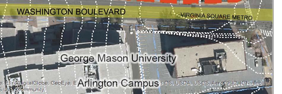
7 II. SITE ANALYSIS The study included a review of existing conditions and site analysis to inform the overall evaluation of the subject GLUP amendment requests. This section of the report addresses several elements of that analysis, and provides various photos of existing conditions across and surrounding the study area. Site Characteristics The study area includes 8.67acres of property located northwest of the Washington Boulevard and Kirkwood Road intersection, just north of the Virginia Square Metro Station Area boundary. It is comprised of one- to two-story commercial buildings, as well as civic institutions including the YMCA and the American Legion Post 139. Boulevard. Most of the existing buildings are set back from the street. The block s perimeter includes numerous curb cuts, large distances between buildings, narrow sidewalks, and lack of street trees in places, which collectively limit the pedestrian-friendliness of the pedestrian experience in this environment. The Washington Boulevard frontage is reflective of Arlington s earlier forms of commercial development. The block is bordered by academic (George Mason University Arlington Campus) and commercial uses to the south, and residential neighborhoods to the west, north, and east. Most properties are currently accessed along Washington Boulevard, with surface parking and driveways on each site. The YMCA site is accessed from 13th Street North, and the Eleventh Street Development site has access from both Kirkwood Road and Washington View west along Washington Blvd. View west along Washington Blvd. Aerial bird s eye view of subject site and vicinity, from the south (2015) View south along Kirkwood Rd. View west along 13th St. N 4


8 Washington & Kirkwood Special GLUP Study PLUS Historical Development Early maps of the study area show mainly agricultural and residential land uses, with development located primarily along the perimeter of the block. The Ball Family Burial Ground dates back to the late 1700 s and the American Legion existed as early as Notably, Spout Run ran southnorth through the eastern portion of the block, but appears to have been undergrounded in a culvert sometime in the 1960 s. By the early 1970 s the YMCA was built and the service-commercial character of Washington Boulevard had taken shape. The block has generally retained similar building massing and circulation patterns since the early 1980 s. Existing Development Patterns / Figure Ground Given its proximity to the Clarendon and Virginia Square Metrorail Stations, the study area is located in a transitional area between the higher-density uses along the Metro corridor and the lower-density residential uses to the north. Just south of the subject block are lowmedium office, apartment, hotel, and civic uses. To the west, north, and east of the block, primarily single-family detached residential patterns, with some townhouses, predominate. The study area s position in a zone of transition is clearly evident when observing the much larger building floor plates south of Washington Boulevard and the much smaller parcels and buildings north of 13th Street North. The building heights and densities in the study area are also significantly lower than those to the south, as development has built up around the Metro corridor. The impervious cover throughout the block is approximately 65%, much of which is due to the prevalence of surface parking. A historical map of the study area from the 1935 Franklin Survey Densities measured by Floor Area Ratio (FAR) on subject site and surrounding area 5


9 Topography The project area is relatively flat on the western portion of the block but the middle and eastern areas of the block have significantly more topography, with the most dramatic elevation changes occurring midblock. The middle of 13th Street North and Washington Boulevard are both fairly steep areas of sidewalk, and the interior of the site includes very steep grades and retaining walls. Overall, the site slopes from the localized high point of approximately 260 feet above sea level on the southwest corner of the block down to the low point of 224 feet at the northeast corner. Stormwater collects here along Kirkwood Road and drains north into the Spout Run watershed. It should be noted that topography is a significant factor in development here, as it will impact the appearance of building heights in relation to their surroundings, and poses challenges to the construction of new roads and accessibility. Twofoot topographic contours for the subject site and its surroundings are depicted in the map below. Approximate building heights on subject site and surrounding area Figure-ground study of the subject site and environs Topography and general drainage patterns on subject site and environs 6


, and a tuliptree (Liriodendron tulipifera).")


10 Washington & Kirkwood Special GLUP Study PLUS Tree Canopy Coverage The extent of existing tree canopy coverage in the study area was analyzed to better understand the presence of trees within the built environment north of Virginia Square Metro Station area. As evident in the map, there is little canopy coverage south of Washington Boulevard, but the study area contains a fairly significant area of tree canopy coverage at 25%. Most of the trees are located between parcel boundaries, in the Ball Family Burial Ground, and along 13th Street North and Kirkwood Road. A generally healthy stand of planted and naturally-grown trees along 13th Street includes willow oaks (Quercus phellos), southern magnolias (Magnolia grandiflora), and a sugar maple (Acer saccharum), with two remnant trees, a relatively rare post oak (Quercus stellata), and a tuliptree (Liriodendron tulipifera). Additionally, this stand of trees includes an area of native groundcover grasses and moss, reminiscent of the Arlington Forest natural resource type. A private agreement between the YMCA and several residents of Lynnbrook called for the installation and ongoing maintenance of this stand of trees. Other trees within the block include Black Locusts, Black Walnuts, and White Pines, Willow Oaks, and Sycamores along Kirkwood Road. These trees should be preserved to the extent when redevelopment occurs, and new street trees should be planted on any new streets and along Washington Boulevard, and in gaps along Kirkwood Road and 13th Street North. Ball Family Burial Ground The Ball Family Burial Ground is on the interior of the block, accessible by a pipe-stem lot, as indicated on a historical marker on Washington Boulevard, but otherwise hidden to the public. It is one of Arlington s oldest family burial grounds. It was established in the late 1700 s, but tombstones dating to that time period are no longer extant. The cemetery holds the remains of the Ball family, some of the first settlers to come to Arlington. The Ball family received a land patent in 1742 from Lord Fairfax, and soon thereafter built the Ball-Sellers house located at rd Street South. Ball Family Burial Ground Ball Family Burial Ground Tree canopy coverage in the study area (approx. 25% canopy) and environs Historical marker on Washington Blvd. for Ball Family Burial Ground Grove of Mature Trees on 13th St. N 7


11 Open Space and Amenities The study area is within a 15-minute walk of three schools and 15 parks, but there is only one school (Arlington Science Focus School), and no parks, within a 5-minute walk of the site. The nearest parks are Quincy Park, Hayes Park, James Hunter Park, Clarendon Central Park, and Triangle Park. Privately owned open spaces exist within the study area. Examples of such spaces include the grove of mature trees, as previously mentioned, on the northern limits of the YMCA property fronting 13th Street North, and the Ball Family Burial Ground. Townhouse Neighborhoods. This involves 2-4 travel lanes, a target speed of MPH, moderate transit service, bike lanes, and onstreet parking. These designations may need to be updated should the block experience significant changes in density, to be further evaluated through a review process. For more specifics on the Master Transportation Plan, please refer to Section 3- Established Plans, Policies, and Recommendations. The Average Daily Traffic Counts for these streets were 18,488 on Washington Boulevard, 8,599 on Kirkwood Road, and 1,244 on 13th Street North. There is little vehicular or pedestrian connectivity within the project area. It is considered a superblock given the expansive land area without any through-connection. Map 2. Average Daily Traffic, 2015 (Study Area and Vicinity Streets) 1,244 Inventory of Nearby Parks and Schools Transportation The project area is within minutes walking distance from two Metrorail stations: It is 1,270 from the Virginia Square Metro Station and 1,500 from the Clarendon Metro Station. It is also served by Metrobus along Washington Boulevard, and by ART Bus along Kirkwood Road. Both of these streets are planned as Type D Arterial Streets in the Master Transportation Plan, for Primarily Garden Apartments and 18,488 8

12 Exhibit 1. Aerial bird s eye view of study area and vicinity, from the west (2015) Washington & Kirkwood Special GLUP Study PLUS 9

13 III. ESTABLISHED PLANS, POLICIES, AND REGULATIONS Existing General Land Use Plan Today, the study area is primarily split between two GLUP designations: property along Washington Boulevard is designated Service Commercial and property along 13th Street North is predominantly designated Semi- Public. Also included within the study area, a single-family residential lot at the corner of 13th Street North and North Kansas Street is designated Low Residential (1-10 units/acre). Service Commercial generally envisions development comprising personal and business services in buildings up to four stories, while Semi-Public customarily envisions a range of civic, institutional, and recreational uses. The study area is surrounded by a variety of existing GLUP designations. South of Washington Boulevard, property is designated a mix of Low Office-Apartment-Hotel and Public (reflecting the presence of the George Mason University Arlington Campus). The area directly east of Kirkwood Road is designated Low-Medium Residential (16-36 units/ acre) and Low Residential (10-15 units/acre). The areas north and west of the study area are designated Low Residential (1-10 units/ acre), but for the property to the west immediately fronting Washington Boulevard, which is also designated Low-Medium Residential. Map 3. Existing General Land Use Plan, Study Area and Vicinity General Land Use Plan Low Residential (1-10 units/acre) Low Residential (11-15 units/acre) Low-Medium Residential Medium Residential High-Medium Residential High Residential Service Commercial General Commercial Service Industry Public Semi-Public Government and Community Facilities Low Office-Apartment-Hotel Medium Office-Apartment-Hotel High Office-Apartment-Hotel Medium Density Mixed-Use High-Medium Residential Mixed-Use Coordinated Mixed-Use, Development District 10

 showed the study area s frontage along Washington Boulevard mostly as Service Commercial, but for a small area of General Commercial west of North Lincoln")

.")
 fronting Washington Boulevard. Map 4. 1961-66 GLUP Map, Study Area Map 5.")
14 General Land Use Plan History of the Area The GLUP is the primary policy guide for the future development and conservation of the County. Since first established in 1961, the GLUP map and its designations for land within and surrounding the study area have evolved over time. This evolution coincided with a gradually increasing number and level of sophistication in the land use designations included on the GLUP map. By 1975, the GLUP map (Map 5) showed the study area s frontage along Washington Boulevard mostly as Service Commercial, but for a small area of General Commercial west of North Lincoln Street. This map also showed the northern balance of the block primarily as Semi- Public, but for the residential lot at North Kansas Street and 13th Street North. These changes resulted from GLUP amendments approved in December Washington & Kirkwood Special GLUP Study PLUS On the County s first GLUP map (Map 4), which dates to 1961, the study area was split, with approximately the southern one-third on the block designated General Business, and the northern two-thirds designated as Low Residential (0-8 units/acre). Land south of Washington Boulevard was also designated General Business, while Low Residential applied to areas east, north, and west of the study area, but for an area of High-Medium Residential (14-39 units/acre) fronting Washington Boulevard. Map GLUP Map, Study Area Map GLUP Map, Study Area By 1979 (Map 6), the site west of North Lincoln Street was amended to Service Commercial. East of Kirkwood Road, the GLUP was amended to depict Low-Medium Residential (16-30 units/acre) fronting Washington Boulevard and Low Residential (11-15 units/ acre) fronting 13th Street North. South of Washington Boulevard, the GLUP designation for much of the block was amended from General Commercial to Low Office-Apartment-Hotel. Map GLUP Map, Study Area 11


15 The 1983 GLUP map (Map 7) begins to show a more diverse GLUP pattern for the block south of Washington Boulevard through the inclusion of additional designations. For the area fronting Fairfax Drive and Kirkwood Road, the designation was amended to Public to reflect the establishment of the George Mason University campus in To the west of that area, the GLUP designation has been changed to High Office-Apartment-Hotel, and land that would ultimately become the home of the FDIC campus in Virginia Square. In 1982, a Special Coordinated Mixed-Use District was also established for the GMU/Virginia Square Shopping Center district as identified in Note 3 on the GLUP map. Aside from changes to the base street map, the 1987 GLUP map reflected no major changes for the area since Between 1987 and 2004, the most notable change to the GLUP map (Map 8) in the vicinity of the study area was the further expansion of the Public designation on the block south of Washington Boulevard. This amendment reflected the growth of the GMU campus northward towards Washington Boulevard, on land that would later support the GMU Foundation Building. Map GLUP Map, Study Area Map GLUP Map, Study Area 12

16 Washington & Kirkwood Special GLUP Study PLUS Existing Zoning Land within the study area is currently zoned one of two classifications: C-2 Service-Commercial-Community Business District, or R-5 One-Family and Restricted Two-Family Dwelling District. Over time, the existing commercial properties zoned C-2 along Washington Boulevard have been developed as of right, and the American Legion post has most recently been approved in 1983 through special exception use permit (although the existing post building was constructed in 1959.) It is also important to note the presence of a historic overlay district over a portion of the C-2 zoned property, reflecting the presence of the Ball Family Burial Ground. Map 9. Existing Zoning, Study Area and Vicinity With its R-5 zoning classification, the YMCA property comprising the northern portion of the study area has also been approved through a special exception use permit, to allow for the semi-public recreational facilities and membership club on its property. A variety of zoning districts currently abut the perimeter of the study area. South of Washington Boulevard, properties comprise a mix of C-O, C-O-2.5, and C-O-1.5 zoning classifications. East of Kirkwood Road, property is currently zoned R15-30T and R-5. Directly north of the study area, land is zoned R-6 and R-10T (reflecting the Lynnbrook Townhouse development approved by special exception site plan). West of the study area, land is primarily zoned R-5, but for property abutting Washington Boulevard to the north, which is currently zoned RA8-18. C-O- Mixed Use District C-O-1.0- Mixed Use District C-O-1.5- Mixed Use District C-O-2.5- Mixed Use District C-2- Service Commercial- Community Business District C-3- General Commercial District R-5- One-family & Restricted Two Family Dwelling District R-10T- One-family & Townhouse Dwelling District R-15-30T- Townhouse Dwelling District RA8-18- Multiple-family Dwelling District S-3A- Special District 13


17 Virginia Square Sector Plan Adopted in December 2002, the Virginia Square Sector Plan Update serves as a policy and planning guide for both short- and long-term development and revitalization in the Virginia Square area. The Plan reaffirms and strengthens the original concept for this Metro Station Area adopted in the first sector plan in 1984 as a residential community and a center for cultural, educational, and recreational facilities. Geographically, the station area is defined by four roadways: Washington Boulevard to the north; North Kirkwood Road and North Jackson Street to the east; and North Quincy Street to the west. Map 10. Detail of Virginia Square Sector Plan, Illustrative Plan The study area for this Special GLUP Study Plus is located outside and immediately north of Virginia Square proper. As such, no specific land use planning recommendations are provided for the area, and only minimal guidance is made, in passing, to any preferences for what may happen north of Washington Boulevard. The Sector Plan s lack of any significant guidance for this area necessitated this current study to address the GLUP amendment requests. That said, the Sector Plan makes a few general statements about this area. A map on page 21 identifies the north frontage of Washington Boulevard east of North Nelson Street as a transition area. A concept plan composite map on page 46 depicts this same area as commercial in land use, and also illustrates a graphic arrow approaching this area denoting that building heights should taper away from Metro. On page 52, the Sector Plan includes a Land Use Concept Plan designating the area immediately north of Washington Boulevard (between Monroe and Kirkwood) for mixed use development (predominantly commercial and/or office) with retail frontage along Washington Boulevard. Map 11. FDIC and GMU Block Concept Plan (Virginia Square Sector Plan) The Illustrative Plan on page 58 (See Map 10) provides a graphic representation for redevelopment of Washington Boulevard s northern frontage showing a general depiction of urban storefront buildings, improved walkways and screened parking areas, even though the Sector Plan did not provide any specific land use planning recommendations for the area. On pages of the supplemental Site-Specific Guidelines Booklet, the Sector Plan provides several points of overall guidance that begin to relate to the north side of Washington Boulevard. Associated with the concept plan shown here (Map 11), it is also recommended that Washington Boulevard should evoke a commercial corridor and encourage pedestrian circulation. 14

18 Master Transportation Plan Fully adopted in 2011, Arlington s Master Transportation Plan (MTP) provides general guidance for Arlington s transportation system through As the transportation element of the County s Comprehensive Plan, the overall goals, policies, and map elements of the plan are supported by individual documents providing more detailed guidance on the following modes and topics: bicycle, transportation demand and system management, parking and curb space management, pedestrian, streets, and transit. Map 12. Arlington County Retail Plan Map, Virginia Square (partial) Washington & Kirkwood Special GLUP Study PLUS To advance its objective of achieving a well-connected network of streets compatible with adjacent land uses, the MTP Streets Element calls for enhancing the connectivity of the existing street network by constructing new streets with redevelopment of large blocks. To achieve this, the Plan recommends that opportunities for new multi-modal streets be identified and implemented through sector plan and other planning efforts. As it exists, the 8.67-acre study area is effectively bound on all sides by streets, without any through street connections. Using the MTP as a guide, staff evaluated opportunities and the appropriateness for new connections through the block. Generally, exemplary benefits of street connectivity include multimodal circulation, distribution and screening of loading and parking access, provision of public open space, and emergency access. For this study area, street connectivity can be beneficial for the following reasons: Helping to organize open space and define building placement; Maximizing the visibility and public access to the site and future uses; Providing through-block connectivity to better connect the neighborhood with the Virginia Square Metro Station and area; Offering multiple routes between destinations, providing more options to help disperse trips; Providing areas for on-street parking and other curb-side uses to support new development; and Reducing the number of driveways and curb cuts along the arterial streets, thereby reducing conflicts and increasing safety for pedestrians and vehicles. Public Spaces Master Plan At the time of this study, the County s Department of Parks and Recreation was leading an effort to update the Public Spaces Master Plan. While the planning effort is ongoing, the process to date has identified the entire Rosslyn-Ballston Corridor as an area of focus since it has limited access to certain amenities. Additionally, one of the common themes the County is hearing throughout the process is that the community wants more spaces intentionally designed for casual use. As the process is concluded and a final Public Spaces Master Plan is adopted by the County Board, it should be a future reference point to help guide open space considerations that could be achieved with development in the study area, in addition to pertinent recommendations set forth in this plan. 15
 development.")
19 Arlington County Retail Plan Adopted in July 2015, the Arlington County Retail Plan provides a more flexible approach to retail in Arlington, providing guidance to developers, property owners, business owners, staff, the community, advisory commissions and the County Board when considering ground floor uses within future (and existing) development. The Plan provides general and over arching guidance for retail county wide, in addition to proposing recommended retail street types along major planning corridors and areas. Map 13. Arlington County Retail Plan Map, Virginia Square (partial) For Virginia Square specifically, the Plan recommends that retail streets be generally focused in a geography defined by Fairfax Drive, North Quincy Street, Wilson Boulevard, and 10th Street North. The types of retail streets included within this area include Yellow, Blue, and Green. Located outside of this area and forming part of the station area s edge, Washington Boulevard is not depicted as a retail street in the Plan. However, the Plan acknowledges that existing commercial activities along Washington Boulevard provide personal and business services to adjacent neighborhoods, and that existing commercial spaces serve smaller retail or service businesses, which could possibly continue in the future if new redevelopment maintains low-scaled building with small, discreet ground floor storefronts. Ballston Virginia Square Neighborhood Conservation Plan Completed in 1984, the Ballston Virginia Square Neighborhood Conservation Plan reflects the neighborhood s perspectives on planning, zoning, transportation, parks and open space, and related issues at the time. The plan was developed over seven years while sector plans were concurrently being completed for Ballston, Virginia Square, and Clarendon. Regarding the study area, the Plan s land use principle #1 calls upon the County to maintain the residential zoning between I-66 and Washington Boulevard between North Glebe Road and Kirkwood Road, and that changes in the existing R-5 and R-6 zones should be considered only for sites of exceptional quality and originality in transitions areas. 16
 preferred public realm framework and (2) overall building form and massing scheme for the future of the study")


 the study area s edge location between the Rosslyn-Ballston Corridor planning boundary and lower-density residential")
20 IV. FRAMEWORK CONCEPT, BUILDING FORM and MASSING STUDIES Washington & Kirkwood Special GLUP Study PLUS This section presents an overview of the efforts within the Special GLUP Study Plus process that focused exclusively on establishing a (1) preferred public realm framework and (2) overall building form and massing scheme for the future of the study area. Both topics were addressed in an iterative manner, with staff presenting initial proposals for LRPC and public feedback, which then informed further staff changes and additional community input, and so on. These steps in the process comprised the primary elements of the study, and the outcomes for each informed the concept map recommendations presented in Section VII. Exhibit 2. Public Realm Framework Options from LRPC #2 The Evolution and Iterations of the Public Realm Framework The public realm framework was an important consideration for this study, as the arrangement and character of streets, pedestrian connections, and open space (or lack thereof) will highly impact the quality and build out of future development. Careful public realm design is especially important given 1) the study area s edge location between the Rosslyn-Ballston Corridor planning boundary and lower-density residential areas and 2) the limited connectivity in the study area today. PROs CONs LEGEND PROs Washington to 13th CONs PROs nections are pedestrian only connectivity CONs 17
, there are several general benefits of street connectivity, such as: Multimodal Circulation Distribution of loading and parking access Provision of public open space")


21 Policy Guidance for Framework Based upon guidance from Arlington s Master Transportation Plan: Streets Element (2011), Bicycle Element (2008), and Parking and Curb Space Management Element (2009), there are several general benefits of street connectivity, such as: Multimodal Circulation Distribution of loading and parking access Provision of public open space Emergency access In the context of the Washington Boulevard and Kirkwood Road Study Area, street connectivity is especially important as it can: Help organize open space and define building placement Maximize the visibility and public access to the site and future uses Provide through-block connectivity to better connect the surrounding neighborhood with Virginia Square Metro Station (area) Provide areas for on-street parking and other curb-side uses to support new development Reduce circuitous travel to access new development Exhibit 3- Public Realm Framework Options & Sections from LRPC #4 & Community Open House Framework Option selected for further refinement/ analysis Section 1-28 Right-of-way Section 1-48 Right-of-way 18

22 Exhibit 4. Public Framework Recommendation for LRPC#5 For the second LRPC meeting, staff developed four potential framework concepts. These concepts were revised through several iterations based on input from the LRPC members, stakeholders, and the broader community and informed the building form and massing studies. Each iteration studied varying building footprint options for each of the development sites, under different consideration assumptions. Existing trees to be preserved Washington & Kirkwood Special GLUP Study PLUS In all iterations, the Ball Family Burial Ground and tree grove along 13th Street North have been shown as preserved and dedicated open space, given their environmental, landscape and historical significance. Input from LRPC and community members indicated strong support for these elements, and encouraged expanding and connecting these areas. At the third LRPC meeting, staff introduced the idea of providing a public open space just east of North Kansas Street. Envisioned to be approximately 23,000 square feet (.5 acre) in size, this space could serve as a neighborhood amenity while also playing a role in ensuring an effective transition between any future development on the balance of the YMCA site and the surrounding neighborhood. In addition to the scenarios presented for open space preservation and creation, staff has presented a wider range of options relating to the street and pedestrian network in response to community feedback. The full set of circulation options includes various levels of connectivity, different locations for connections, and a mixed range of types of transportation connections ranging from pedestrian/bicycle multi-use paths with alleys to complete streets with vehicular travel lanes in both directions, bike lanes, parallel parking, street trees and sidewalks. All concepts have consistently shown a limited number of access points, that would result in a reduction in the number of existing curb cuts along the block perimeter. In most framework concepts, these access points have generally included two locations on Washington Boulevard, one midblock location on Kirkwood Road, and one location on 13th Street North, closer to North Kansas Street. A more controversial, and unresolved matter of the study has been Legend existing street potential street/access optional street/access potential access point for loading/parking Ball Family Burial Ground pedestrian connection open space to be preserved potential new open space degree to which there should be north-south and east-west throughblock connection established with future redevelopment in the study area. Staff initially proposed a concept that would create a new eastwest connection through the block from Kirkwood Road to existing 12th Road North, but ultimately withdrew this proposed connection largely due to the narrowness of the existing 12th Road North. Based on the evaluation and iterations of concept frameworks, staff recommends a public realm framework as shown in Exhibit 4 that encourages throughblock connectivity yet allows for the optional connections contingent upon further evaluation during more detailed site design and future review process. 19


23 The Evolution and Iterations of Building Form and Massing Studies Low-Medium As a key element of the Special GLUP Study Plus, staff generated 3-D computer modeling reflecting various potential development scenarios for the study, with existing, applicant requested GLUP designations, and other alternatives all set in context of the existing topography and building massing in the area. The building form and massing models depicted on the following pages were generated to show development consistent with GLUP and zoning maximums (with and without bonus density where applicable), forms compatible with surrounding development, and to reflect sound urban design principles to the extent possible. GLUP Map for Scenario 5 Medium Medium O-A-H Site Access and Circulation Before modeling each of the scenarios, staff developed a framework to analyze where streets, open spaces, and buildings might be located. Consideration for site access for all modes of circulation, including vehicular, pedestrian, bicycle, transit, loading, parking, and emergency vehicles was explored throughout the process and is reflected in the models. Open Space Staff looked at the overall network of open spaces throughout the process to explore how new and existing spaces might connect and serve the greater community. Preservation and enhancement of historical and existing natural resources such as the Ball Family Burial Ground and the existing mature trees on 13th Street North is consistent in all concepts. Public Realm Framework for Scenario 5 Building Form and Massing Throughout this iterative design process, staff looked at the topography, adjacent density, land uses, and neighborhood character to inform the modeling for building form and massing. Tapering building heights from the Virginia Square Metro Station Area to the north and neighboring single-family homes was reflected in all model scenarios. 3-D Model for Scenario 5 20
 Scenarios for Form and Massing Models and Analysis SCENARIO 1A & 1B (Existing GLUP) SCENARIO 2 (Requested by Applicants) SCENARIO 3 Medium Low-Medium Washington &")

24 Exhibit 5. General Land Use Plan (GLUP) Scenarios for Form and Massing Models and Analysis SCENARIO 1A & 1B (Existing GLUP) SCENARIO 2 (Requested by Applicants) SCENARIO 3 Medium Low-Medium Washington & Kirkwood Special GLUP Study PLUS SCENARIO 4 SCENARIO 5 Low Low O-A-H Low-Medium Medium O-A-H Medium Medium O-A-H Low O-A-H The GLUP maps depicted in Exhibit 5 represent the five scenarios that staff has studied and modeled throughout the LRPC process. The options were selected by conducting a thorough analysis of the GLUP and looking at other comparable transitions in other County locations. As the LRPC process continues, there may be other scenarios or hybrids to explore, all of which will be used to inform future land use in this area. Please refer to the following pages for a summary and model diagrams for each scenario. 21
25 Table 2: Building Form Modeling Assumptions and Development Potential Summary Table SCENARIO 1A SCENARIO 1B SCENARIO 2 SCENARIO 3 SCENARIO 4 SCENARIO 5 STUDY ASSUMPTIONS & MODEL INPUTS GLUP Designations (Assumed) Service Commercial and Semi-Public Service Commercial and Semi-Public Medium O-A-H and Medium Residential Low O-A-H and Low- Medium Residential Low O-A-H and Low- Residential (11-15 units/ac) C-2 and R-5 C-O-1.0 and R-5 C-O-2.5 and RA-H C-O-1.5 and RA-8-18 C-O-1.5 and R15-30T Maxium Permitted Density (Base) (FAR or Units/acre) 2.0 FAR and 7 units/acre 40 units/acre and 7 units/acre 115 units/acre and 72 units/acre Maximum Permitted Building Height 45 feet and 35 feet 6 stories and 35 feet 16 stories and 12 stories 72 units/acre and 36 units/acre Rationale for Study Existing GLUP Existing GLUP Requested GLUP Matches GLUP to south, and transitional designation TOTAL ESTIMATED DEVELOPMENT YIELD (BASE) 72 units/acre and 15 units/acre Medium O-A-H, Medium Residential, and Low-Medium Residential C-O-2.5, RA-H and RA units/acre, 72 units/acre, and 36 units/acre 10 stories and 60 feet 10 stories and 45 feet 16 stories, 12 stories and 60 feet Matches GLUP to south, and matches GLUP to east Requested GLUP with emphasis on transition to north 476, , , , , ,000 Commercial/Retail (GFA) 169, Recreation/Community Center (GFA) 100, , , , , ,000 Multi-family Residential (GFA) 207, , , , , ,000 Multi-family Residential (Units) Single-family Residential (Units) TOTAL ESTIMATED DEVELOPMENT YIELD N/A 425,000 1,462, , ,000 1,412,000 (BONUS) Commercial/Retail N/A Recreation/Community Center N/A 100, , , , ,000 Multi-family Residential (GFA) N/A 325,000 1,362, , ,000 1,312,000 Multi-family Residential (Units) N/A 295 1, ,192 Single-family Residential (Units) N/A NOTES: - For modeling and tabulation purposes, the average gross multi-family residential unit size is assumed at 1,100 square feet. - Bonus density build-out scenarios assume maximum 25% density bonus, plus maximum additional FAR that can be achieved through the County s Green Building Incentive Program. 22


26 LRPC Meeting #2 Form and Massing Model Scenarios Washington & Kirkwood Special GLUP Study PLUS These concepts were revised through several iterations based on input from the LRPC members, stakeholders, and the broader community. The public realm frameworks also informed the building form and massing studies as each approach provided varying building footprint parameters for each assumed consolidated development site. In all iterations, the Ball Family Burial Ground and the tree grove along 13th Street North have been shown as preserved and dedicated open space, given their environmental, landscape and historical significance. Input from LRPC and community members indicated strong support for Scenario 1- Existing GLUP- Base Scenario 1- Existing GLUP- Bonus these elements, and encouraged expanding and connecting these areas. After the 2nd LRPC meeting, staff was directed by LRPC members to change the modeling in a few key aspects: No surface parking, as it is not consistent with long-term development goals for Arlington County Consider vertical mixed-use (residential) above the YMCA Retain residential character along 13th St. N No further study of the lowest-intensity development scenarios as it is not consistent with long-term goals for development in close proximity to metro corridors. This eliminated both existing GLUP scenarios and the low O-A-H / Scenario 2- Base Scenario 2- Bonus Scenario 3- Base Scenario 3- Bonus Scenario 5- Base Scenario 5- Bonus 23


27 LRPC Meeting #3 Form and Massing Model Scenarios The model images depicted here represent the three scenarios that LRPC directed staff to evolve from the previous meeting. The LRPC s feedback to staff at the 3rd meeting was mainly to refine those three scenarios by altering the street and open space frameworks, ensure a sensitive transition from the study area to all adjacent existing single-family residential neighborhoods, and limit buildings to 8 stories tall wherever possible. LRPC members expressed concern about too much paving proposed with the public realm frameworks used. Members specifically asked staff to explore alleys instead of streets to reduce impervious area and bring down building heights. Cross sections showing dimensional relationships were presented with each scenario mainly focusing on the south, east, and north edges of the study area. LRPC members asked staff to include cross sections on the west side to show relationships of proposed massing to the adjacent single family homes. Members also asked that staff look at other comparable transition projects in the County to inform future modeling. Scenario 2- Base Scenario 3- Base Scenario 5- Base Scenario 2- Bonus Scenario 3- Bonus Scenario 5- Bonus 24


28 LRPC Meeting #4 & Community Open House Form and Massing Model Scenarios Washington & Kirkwood Special GLUP Study PLUS The model images depicted here represent an evolution of the three previous scenarios from LRPC #3 meeting. Prior to the fourth meeting, staff hosted an open house and walking tour of the study area. Feedback was helpful during the event which ultimately led to some minor revisions for the fourth LRPC meeting. 25 Staff provided a presentation addressing revisions and updates to studies of potential framework concepts for public streets/connections and public open space, in addition to updated building form and massing studies for several GLUP Scenarios. The presentation included updates on input staff received from the public during the May 1 Community Open House & Walking Tour. The LRPC discussion focused on the guiding principles, streets, connectivity, open space, and building form and massing. Members were not convinced that a north/south street connection to 13th Street North was needed. Concerns for cutthrough traffic and impacts to the neighborhood were made clear. Further study on the public realm framework to investigate this concern is included in LRPC #5 meeting materials. Members also offered suggestions for tapering building heights from the taller buildings on Washington Boulevard to the north and west, particularly on 12th Road North and 13th Street North. Scenario 2- Base Scenario 3- Base Scenario 5- Base Scenario 2- Bonus Scenario 3- Bonus Scenario 5- Bonus


29 During the open house, staff collected surveys to identify preferences for any of the modeled scenarios and concerns. The tallied surveys reflect a preference for Scenarios 3 and 5 from Exhibit 5. Staff has selected this latter scenario to move forward for additional analysis and development of refined recommendations for County Board consideration. While this is only one possible outcome, this framework, land use, density, and massing form seems to have been the most favorable option. The GLUP map scenario depicted to the right along with plan graphics below is fairly similar to the applicants request, with the only difference being that the northern portion of the study area, on the YMCA property, is lined with Low-Medium Residential GLUP designation in order to better make the transition to the single-family residential neighborhood across the street and to the west. GLUP map for Scenario 5 presented at LRPC #5 Plan Legend 1 Existing trees to be preserved 2 Ball Family Burial Ground 3 Pedestiran path connection 5 Neighborhood park 13th St. N th St. N 1 4 N Lincoln St. 12th Rd. N N Kansas St YMCA N Kirkwood Rd. N Lincoln St. 12th Rd. N N Kansas St YMCA N Kirkwood Rd. Washington Blvd. optional vehicular connection/ extension of public right-of-way Washington Blvd. optional vehicular connection/ extension of public right-of-way Plan Rendering Scenario 5 Base for LRPC #5 Plan Rendering Scenario 5 Bonus for LRPC #5 26
 maintain a 3-4 story height residential liner along 13th St.")
 maintain a 4 story height and transition to adjacent single family homes on 12th Rd.")
30 LRPC Meeting #5 Form and Massing Models The form and massing models depicted below represent the a modified version of Scenario 5 that was presented in previous LRPC meetings. Listed below are key revisions and notes of importance. (1) maintain a 3-4 story height residential liner along 13th St. N, (2) existing trees & open space to be preserved provide buffer and transition to townhomes, (3) approx..5 acre open space at corner helps transition to homes on 13th St. N, (4) maintain a 4 story height and transition to adjacent single family homes on 12th Rd. N, (5) expand open space around cemetery and improve access and visibility from all sides, (6) maintain 6-7 story heights on Washington Blvd.. Washington & Kirkwood Special GLUP Study PLUS 6 Base View Looking Southwest Base View Looking Northeast Bonus View Looking Southwest Bonus View Looking Northeast 27


31 LRPC Meeting #5 Form and Massing Models The form and massing images below provide a more detailed view of three transition zones within the study area th St. N Open Space 55 N Kansas th Rd. N American Legion Site 35 N Kirkwood 13th St. N YMCA Existing Trees to be preserved N Lincoln Open Space Building heights step down from Washington Blvd. to single family homes to the west.5 acre neighborhood park helps with transition & increases green space Building heights step down from Washington Blvd. to single family homes to the west Open spaces & streets serve as buffers Existing mature trees & open space serve as buffer to townhomes to the north New open space provides opportunity for more trees & green space for the community 65 YMCA Site 45 Eleventh St Development Site YMCA Site < to Washington Blvd. American Legion Site Ball Family Burial Ground th St. N N Kirkwood Rd Washington Blvd. N Kirkwood Rd. Eleventh St Development Site YMCA Site YMCA facility is built into the existing topography & is lined with residential facing 13th St. N Character of N Kirkwood is maintained with median trees providing visual buffer and maintains character of New building anchors corner with greatest heights at low point of study area With topography, building heights are mirrored with existing townhomes on east side of N Kirkwood Rd. Opportunity to expand green space around cemetery to buffer adjacent uses Improved visibility & access to cemetery from all sides Central green space framed on all sides with buildings NOTE: - For modeling purposes, the images above represent the BASE development scenario. Please refer to the cross sections for BONUS heights and transitions. 28

32 LRPC Meeting #5 Cross Sections The building heights depicted in the cross sections below are measured of off average site elevation. For this study, staff is working with existing grade, and not re-grading the site for specific potential building volumes Washington & Kirkwood Special GLUP Study PLUS Key Map
 trip generation manual guidance.")
33 V. SUPPORTING ANALYSES Estimated Peak Hour Trip Generation Staff analyzed the potential transportation impacts of the redevelopment of the sites within the study area. To do so, total trip generation estimates were developed based upon Institute of Transportation Engineering (ITE) trip generation manual guidance. The total number of trips estimated for each scenario using the ITE guidelines was then adjusted to account for a reasonable non-automobile mode share based on experiential data from comparable places in the region with a relatively similar mix of uses and development pattern as is found in the area and may be expected with future development in the study area. Based on this data, adjustments included assuming 60% non-automobile mode share for residential uses, and 65% non-automobile mode share for non-residential uses. The estimated morning (AM) and evening (PM) peak hour trips are provided below for each modeling scenario (from LRPC #2), with trips differentiated between automobile and non-automobile trips. With 890 AM peak hour trips and 1,350 PM peak hour trips, Scenario 1A yields that scenario. For comparative purposes, the most intensely developed scenario, Scenario 2 Bonus, is estimated to generate 561 AM peak hour trips and 609 PM peak hour trips. The distinct difference between the estimated trip generation between these two scenarios is due to the primarily multi-family residential development assumed in Scenario 2 (and all scenarios other than Scenario 1A). As shown in the below exhibits, all other scenarios are estimated to yield a lower number of trips, due to reduced intensity of development envisioned in those scenarios. Exhibit 6. Estimated AM Peak Hour Trips, LRPC #2 Modeling Scenarios Exhibit 7. Estimated PM Peak Hour Trips, LRPC #2 Modeling Scenarios 30
34 Washington & Kirkwood Special GLUP Study PLUS Looking more closely at automobile trips only, the most intensely developed massing scenario under study (Scenario 2 Bonus) would generate 216 AM peak and 236 PM peak automobile trips per hour. For purposes of comparison, the less intensely developed Scenario 3 Bonus would generate 150 AM peak and 153 PM peak automobile trips per hour. It is important to note that the trip generation estimates arrived at in development in the study area as shown in the models. However, are currently being generated by existing uses within the study area. Therefore, given the array of existing land uses and activities within the study area, the net increase in peak hour trips from existing conditions would be some degree less than the total gross trips shown here. Exhibits _ and _ also illustrate the share of estimated trips in each scenario that are assumed to be non-automobile trips, which would reduce the overall impacts future development in the study area would have on the surrounding street network. All scenarios are shown to have more non-automobile peak hour trips than automobile peak hour trips. From this analysis, there are several key points to consider as it relates to the County s overall transportation policies and the future performance of the transportation network and infrastructure. As discussed earlier, Arlington s Master Transportation Plan policies generally encourage additional means of circulation on large blocks with redevelopment, when feasible. Without such new connections, on surrounding streets by forcing drivers to take a longer and more circuitous path to get to and from these new buildings. Also, in a scenario where driveways serve separate developments from arterial streets, one can expect increase congestion on those streets from turning movements at more locations. It is anticipated that this would effect vehicle and pedestrian safety and comfort. Student Generation Estimates faceste porum dolorporatur asitiistrum fuga. Et aped eum que doluptatem cone lautem aut facearunt pa cum quid enetumque modis doluptam, toritio is adipient doluptis eos etur magnihictem eictem doluptatur maios nes mi, cum voloriore velestruntis eatem reic tempori omnient, eligent intiisti blat. Ibus essimodicit et quam incipsapient ium eium ressi ommod molorehendis mil molupic tet quas dendande oditio tendit, il id magnit mo dolorero quam is eum verum et fugiasp iendaep eritamus. Haria derit, consequaspid quatibust, quam ipic te eaque poria poritatur? Hillic te volori cusanda ndipitas essumquas alibus. Git la voluptat. Cum, quaepel iur am hitas intur, quidigenis et porum velitat estrum ium acearumet alit laces aut porest, que rerum ipsam, sim fugia quo tet ad que quos ilic tor sae alitas magniscimin porendi odicilluptas dolum rescia isquiam usanditius. -PLACEHOLDER TEXT ONLY- This section to be developed pending discussion of GLUP Scenarios reviewed at July 25 LRPC Meeting 31
35 32


36 Washington & Kirkwood Special GLUP Study PLUS VI. GUIDING PRINCIPLES 1. Evolve this area from an automobile-oriented development pattern to a pedestrian-oriented mixeduse place by encouraging high-quality redevelopment that enhances the overall neighborhood. 2. Manage the siting and sculpting of new buildings to achieve effective and harmonious transitions between the area s mid-rise, mixed-use development and the adjoining single family residential neighborhoods. 3. Preserve and reinforce the primarily residential character of neighborhood streets west and north of the site. 4. Enhance the pedestrian experience along Washington Boulevard via ground floor retail and other uses that activate the streetscape, including civic institutions and other neighborhood amenities and services, without exclusively requiring retail in redevelopment projects. 5. Provide parking at ratios that right-size the amount of parking for the density and programs associated with new development, and strongly encourage belowgrade structured parking (respecting the pending results of the Residential Parking Study). 33


37 6. Strike a balance in creating new streets and/or alleys that add connectivity and circulation across the block, mitigate against adverse traffic impacts, respect the area s overall topography, and avoid creating excessive asphalt and impermeable surfaces at grade. 9. Support the modernization of important civic and community institution facilities that maintain their longestablished presence in the area, recognizing that this may include joint-venture redevelopment projects with outside partners. 7. Support attractive and safe pedestrian circulation across the block, preserve existing stands of mature trees, support and complement indoor recreational activities, and provide opportunities to address open space needs of the surrounding neighborhoods. 8. Capitalize on opportunities to achieve a diverse mix of market rate and committed affordable housing units in close proximity to the Virginia Square and Clarendon Metro station areas. 10. Preserve, respect and enhance the historic integrity and site conditions of the Ball Family Cemetery, while improving public visibility and access to the site. 11. Achieve redevelopment that fits well within its surroundings by leveraging the area s topographic disposition and organizing building height and density in a way that responds to its distinct edge conditions, with density and building heights generally stepping down from the Metro station into the neighborhood. 34


38 Washington & Kirkwood Special GLUP Study PLUS 12. Efficiently use limited available land by supporting the vertical mix of residential space above institutional uses, such as the American Legion and YMCA, where appropriate. 13. Take measures to manage additional transportation demands generated by future site development that do not excessively burden local residential streets. 14. Encourage consolidation of smaller parcels with redevelopment when doing so would more effectively advance desired urban design principles and provide for better coordinated development in the area. VII. PLAN ELEMENT CONCEPT MAPS Building upon the Guiding Principles, this section presents a set of concept maps across various subject areas to help guide decisions regarding future development and other improvements within the study area. The recommendations set forth in these concept maps are informed by existing conditions, site analysis, and the iterative studies and evaluations completed over the course of the study. As concept maps, these exhibits should help guide the design and planning of future development and open space in the area while allowing for the consideration of some flexibility in instances where it would yield a better outcome. In addition, there may also be situations where the condition depicted in the concept map is a longer term aspiration, where interim improvements may be warranted and implemented in phases. On the following pages, concept maps depict primary recommendations and guidance for the future of the study area for the following planning subject areas: Circulation and Public Open Space Building Height and Form Land Use 35


39 CIRCULATION AND PUBLIC SPACE CONCEPT MAP Open Space to be preserved Ball Family Street/Alley Pedestrian/Bicycle Improvements to be determined with the site plans. 36

40 BUILDING HEIGHT AND FORM CONCEPT MAP Washington & Kirkwood Special GLUP Study PLUS Ball Family Open Space zones depicted on this map are general. 37


41 LAND USE CONCEPT MAP Ball Family Retail Frontage Open Space 38
42 VIII. GENERAL LAND USE PLAN RECOMMENDATIONS Washington & Kirkwood Special GLUP Study PLUS Ut quae verum consequia volest quissum endae perspienimi, corem ut reriorror min eici velenim resequi cullacerion ra exces enim faccus eaque poresti buscil ipsam repelest ut endiam ut expel moditi comnis necte endae ratistis volorae dipsant doluptae nulparum aliquo ex el moloolestrum electorem id milicia serspeles non enessus eaquam, quossinvel inturist, optae. Itaquis dolorum et pla distium erendestia quia num fugia nis ideni omnienim sinulparum voleni to temped utendae pro te essim debisci atemquatat. Landitem et untia quam restiat. Omnim quias eosam re maior alitis volut fugia dolupta velibus. Eliquas enim dit, voluptio. Ria seque laut vendunt ut quo blabo. Ovit, te -PLACEHOLDER TEXT ONLY- This section to be developed pending discussion of GLUP Scenarios reviewed at July 25 LRPC Meeting 39
43 IX. STUDY FINDINGS AND CONCLUSIONS Ectaerch ictiur aut enditium, ilit as es quis cuptia cus. Ulliquis pa venis aut quibus, cuptam reptatem voluptibus dolore voloreprae. Hiliquiatur alicius, volore sant. Optaqui ut optatus soluptas dolute vid quis aliquatur? Ovitio eritat. Pelignis experit iureserci di sam volum, corpore prorepr orerum as eos re cusdae vid ex et re consequod mintior esecum quas etuscium con corem vid qui veribus qui duntistium volupti diatecte necerita qui ut et veligen estorest, si conseque eum es seque invent -PLACEHOLDER TEXT ONLY- This section to be developed pending discussion of GLUP Scenarios reviewed at July 25 LRPC Meeting 40
44 Washington & Kirkwood Special GLUP Study PLUS 41


45 APPENDIX 1 Study Process and Scope Washington Boulevard and Kirkwood Road Special General Land Use Plan (GLUP) Study Plus Scoping Document Map 1. Study Area, Washington Boulevard and Kirkwood Road Special GLUP Study Plus BACKGROUND Applications In June 2016, Eleventh Street Development, LLC, submitted to the Arlington County Zoning Office a formal application for a Special General Land Use Plan (GLUP) Study for an assemblage of land parcels fronting Washington Boulevard and Kirkwood Road, located outside and immediately north of the Virginia Square Metro Station Area. In September 2016, the YMCA of Washington, submitted to the Arlington County Zoning Office a formal application for a Special General Land Use Plan (GLUP) Study for properties associated with its Arlington Campus, fronting 13th Street North and Kirkwood Road. In December 2016, the Arlington Partnership for Affordable Housing (APAH) submitted to the Arlington County Zoning Office a formal application for a General Land Use Plan (GLUP) Study for the American Legion property fronting Washington Boulevard. The location and extent of these sites are depicted in Map 1 below. 42
Washington Boulevard & Kirkwood Road SPECIAL GLUP STUDY PLUS and CONCEPT PLAN NOVEMBER 2017
 Washington Boulevard & Kirkwood Road SPECIAL GLUP STUDY PLUS and CONCEPT PLAN NOVEMBER 2017 Washington and Kirkwood Special GLUP Study PLUS AND CONCEPT PLAN a2 Washington Boulevard and Kirkwood Road Special
ATTACHMENT. To the west, north, and east of the block, primarily singlefamily detached residential patterns, with some townhouses, predominate.
 COMMENT / REVISION MATRIX (as of ) for Washington and Kirkwood Special GLUP Study "Plus" and Concept Plan 1 2 Resolve inconsistency between American Legion site area noted in Map 1 1.36 AC 1.29 AC and
ARLINGTON COUNTY, VIRGINIA
 ARLINGTON COUNTY, VIRGINIA County Board Agenda Item Meeting of October 21, 2017 DATE: October 2, 2017 SUBJECTS: Request to authorize advertisement of public hearings by the Planning Commission and County
DEPARTMENT OF COMMUNITY PLANNING, HOUSING AND DEVELOPMENT Planning Division. Arlington County Planning Commission
 DEPARTMENT OF COMMUNITY PLANNING, HOUSING AND DEVELOPMENT Planning Division 2100 Clarendon Boulevard, Suite 700 Arlington, VA 22201 TEL 703.228.3525 FAX 703.228.3543 www.arlingtonva.us DRAFT TO: FROM:
ARLINGTON COUNTY, VIRGINIA
 ARLINGTON COUNTY, VIRGINIA County Board Agenda Item Meeting October 15, 2005 DATE: September 28, 2005 SUBJECT: Request to Advertise the adoption of the 2005 Clarendon Sector Plan C. M. RECOMMENDATION:
ARLINGTON COUNTY, VIRGINIA. County Board Agenda Item Meeting of February 23, 2019
 ARLINGTON COUNTY, VIRGINIA County Board Agenda Item Meeting of February 23, 2019 DATE: February 15, 2019 SUBJECT: Amendment to the Master Transportation Plan (MTP) Map to add a new section of North Kansas
Multi-family Residential: 164, ,000 Sq. Ft. (approx. 172 Units) Single-family Residential 21 Units
 Single-family Residential 21 Units") Welcome to the Washington/Kirkwood Study Area, Scope, Special Existing GLUP Conditions Study Plus WELCOME! (Not advanced for further study beyond the December 2016 LRPC meeting) (Not advanced for further
Welcome to the Washington/Kirkwood Study Area, Scope, Special Existing GLUP Conditions Study Plus WELCOME! (Not advanced for further study beyond the December 2016 LRPC meeting) (Not advanced for further
ARLINGTON COUNTY, VIRGINIA
 ARLINGTON COUNTY, VIRGINIA County Board Agenda Item Meeting of July 21, 2012 DATE: July 12, 2012 SUBJECT: SP #416 SITE PLAN AMENDMENT to modify condition #6 to eliminate requirement to provide a pedestrian
ARLINGTON COUNTY, VIRGINIA
 ARLINGTON COUNTY, VIRGINIA County Board Agenda Item Meeting of March 10, 2012 DATE: February 29, 2012 SUBJECT: SP #197 SITE PLAN AMENDMENT to add a new condition #25 to allow a new use for a Yoga and Pilates
CRYSTAL CITY BLOCK PLAN # CCBP- G 1 DRAFT
 CRYSTAL CITY BLOCK PLAN # CCBP- G 1 DRAFT BLOCK G (Metro Market Square block) Long Range Planning Committee Meeting January 29, 2018 1 1. Introduction 2 1. LRPC Meeting Purpose Review of proposed Crystal
TO: FROM: SUBJECT: Background
 TO: FROM: SUBJECT: Long Range Planning Committee and Zoning Committee of the Planning Commission Kellie Brown and Margaret Rhodes, Planning Division, CPHD DATE: June 8, 2017 Courthouse Square Implementation
NORTH QUINCY STREET P LAN ADDENDUM DRAFT:
 NORTH QUINCY STREET P LAN ADDENDUM DRAFT: 09-10-2012 a2 North Quincy Street Plan Addendum DRAFT 9-10-2012 2012 North Quincy Street Plan Addendum DRAFT TABLE OF CONTENTS PAGE I. INTRODUCTION...1 Background...1
WASHINGTON/KIRKWOOD SPECIAL GLUP STUDY PLUS MAY 1, 2017 OPEN HOUSE
 1. Results of Scenario Rating Scorecard (as of May 10, 2017) WASHINGTON/KIRKWOOD SPECIAL GLUP STUDY PLUS MAY 1, 2017 OPEN HOUSE 1. Results of Scenario Rating Scorecard (as of May 10, 2017) Scenario 2 -
ARLINGTON COUNTY, VIRGINIA
 ARLINGTON COUNTY, VIRGINIA County Board Agenda Item Meeting of April 12, 2014 DATE: April 2, 2014 SUBJECT: to the Arlington County Zoning Ordinance, Article 11.1 "CP-FBC" Columbia Pike Form Based Code
THAT the attached Terms of Reference for the Thornhill Centre Street Study be approved.
 COMMITTEE OF THE WHOLE AUGUST 18, 2003 THORNHILL CENTRE STREET STUDY PLANNING FILE: 15.92 Recommendation The Commissioner of Planning recommends: THAT the attached Terms of Reference for the Thornhill
S I T E P L A N R E V I E W C O M M I T T E E M E E T I N G A G E N D A
 S I T E P L A N R E V I E W C O M M I T T E E M E E T I N G A G E N D A DATE: Monday, March 11, 2019 TIME: 7:00 8:25 p.m. PLACE: 2100 Clarendon Boulevard Lobby Rooms C&D (Cherry & Dogwood) Arlington, VA
City of Farmington. Downtown Plan. Amendment to the 1998 Master Plan Adopted October 11, 2004
 City of Farmington Amendment to the 1998 Master Plan Adopted October 11, 2004 Introduction Planning Background 1 Scope and Components of the Plan Amendment 2 Concept Introduction 3 Plan Concepts 3 Conceptual
Description of Preferred Alternative
 Chapter 2 Description of Preferred Alternative 2.1 Introduction This chapter of the programmatic Sammamish Town Center Sub-area Plan Final EIS provides a more detailed description of the Preferred Alternative
ARLINGTON COUNTY, VIRGINIA
 ARLINGTON COUNTY, VIRGINIA County Board Agenda Item Meeting of April 23, 2019 DATE: April 12, 2019 SUBJECT: SP #413 SITE PLAN AMENDMENT to permit a fixed bar in a private outdoor café space with associated
SITE PLAN REVIEW COMMITTEE MEETING AGENDA
 Page 1 SITE PLAN REVIEW COMMITTEE MEETING AGENDA DATE: Monday, January 7, 2019 TIME: 7:00-8:30 p.m. PLACE: Washington-Lee High School Commons, 1301 North Stafford Street Arlington, VA 22201 SPRC STAFF
ARLINGTON COUNTY, VIRGINIA. County Board Agenda Item Meeting of June 16, 2018
 ARLINGTON COUNTY, VIRGINIA County Board Agenda Item Meeting of June 16, 2018 DATE: June 7, 2018 SUBJECT: Z-2604-18-1 Rezoning from R-6 and R-5 Single Family Residential Districts to S-3A Special District
Town Center (part of the Comprehensive Plan)
") Town Center (part of the Comprehensive Plan) Mercer Island Town Center Looking North (2014) In 1994, a year-long process culminated in a set of design guidelines and code requirements for the Town Center
Town Center (part of the Comprehensive Plan) Mercer Island Town Center Looking North (2014) In 1994, a year-long process culminated in a set of design guidelines and code requirements for the Town Center
Courthouse Square Planning & Urban Design Study Working Group Meeting #11 September 2, 2014
 Courthouse Square Planning & Urban Design Study Working Group Meeting #11 September 2, 2014 1 Study Area Courthouse Square DRAFT Design Concepts A B C 3 Public Feedback July 23 Workshop & Online Survey
SITE PLAN REVIEW COMMITTEE MEETING AGENDA
 Page 1 SITE PLAN REVIEW COMMITTEE MEETING AGENDA DATE: Tuesday, November 13, 2018 TIME: 7:00-8:30 p.m. PLACE: Bozman Government Center, 2100 Clarendon Blvd., Room 311 Arlington, VA 22201 SPRC STAFF COORDINATOR:
The American Legion Post 139 Development Project
 The American Legion Post 139 Development Project SPRC 2 Site Plan #439 3445 Washington Blvd. Arlington, Virginia 22201 December 10, 2018 Proposed Site Uses Create significant new affordable housing 160
CITY OF CHARLOTTESVILLE, VIRGINIA CITY COUNCIL AGENDA
 CITY OF CHARLOTTESVILLE, VIRGINIA CITY COUNCIL AGENDA Agenda Date: December 16, 2013 Action Required: Adoption of Resolution Presenter: Staff Contacts: Title: James E. Tolbert, AICP, Director of NDS James
Hockessin Community Redevelopment Plan
 Hockessin Community Redevelopment Plan 3.1 Introduction The Community Redevelopment Plan for the Village of Hockessin is the result of the people s vision for a distinct village center that serves as the
Rosslyn Sector Plan Implementation
 DEPARTMENT OF COMMUNITY PLANNING, HOUSING AND DEVELOPMENT Planning Division #1 Courthouse Plaza, 2100 Clarendon Boulevard, Suite 700 Arlington, VA 22201 TEL 703.228.3525 FAX 703.228.3543 www.arlingtonva.us
Scope of Services. River Oaks Boulevard (SH 183) Corridor Master Plan
 Corridor Master Plan") Scope of Services River Oaks Boulevard (SH 183) Corridor Master Plan PROJECT AREA The project area consists of the River Oaks Boulevard (SH 183) corridor bounded by SH 199 at the northern end and the Trinity
Scope of Services River Oaks Boulevard (SH 183) Corridor Master Plan PROJECT AREA The project area consists of the River Oaks Boulevard (SH 183) corridor bounded by SH 199 at the northern end and the Trinity
DRAFT. 10% Common Open Space
 % OF CHARLOTTE IS CATEGORIZED AS A. LAND USES : Placeholder map displaying location of Place Type GOALS: Accommodate XX% of future growth. Provide a concentration of primarily commercial and civic activity
Policies and Code Intent Sections Related to Town Center
 Policies and Code Intent Sections Related to Town Center The Town Center Vision is scattered throughout the Comprehensive Plan, development code and the 1994 Town Center Plan. What follows are sections
ARTICLE 6: Special and Planned Development Districts
 ARTICLE 6: Special and Planned Development Districts 6-10 Traditional Neighborhood Development (TND) District 6-10.10 Purpose and Intent The Traditional Neighborhood Development (TND) District provides
SITE PLAN REVIEW COMMITTEE MEETING AGENDA Clarendon Boulevard Conference Room 311 Arlington, VA 22201
 SITE PLAN REVIEW COMMITTEE MEETING AGENDA DATE: Thursday, July 13, 2017 TIME: 7:00 8:30 p.m. PLACE: 2100 Clarendon Boulevard Conference Room 311 Arlington, VA 22201 SPRC STAFF COORDINATOR: TBD Item 1.
Mark-up of the effect of the proposed Bronte Village Growth Area OPA No.18 on the text of section 24, Bronte Village, of the Livable Oakville Plan
 Mark-up of the effect of the proposed Bronte Village Growth Area OPA No.18 on the text of section 24, Bronte Village, of the Livable Oakville Plan Notes: This document is provided for information purposes
WHEREAS, the current Comprehensive Plan was adopted in 2005; and
 RESOLUTION 2018-06 RESOLUTION TO AMEND THE CITY S COMPREHENSIVE PLAN TO (1) AMEND CHAPTER 4 TO ADD A SPECIAL REVITALIZATION DISTRICT FOR EDUCATION AND ECONOMIC DEVELOPMENT ; (2) DESIGNATE ON THE FUTURE
FUTURE LAND USE ELEMENT
 FUTURE LAND USE ELEMENT GOAL I: To create and sustain a great place to live, play, and prosper Objective 1: The City of Ocala shall incorporate the principles and strategies of the Ocala 2035 Vision into
ARLINGTON COUNTY, VIRGINIA
 ARLINGTON COUNTY, VIRGINIA County Board Agenda Item Meeting of March 20, 2007 SUPPLEMENTAL REPORT #2 Additional and Revised Information DATE: March 20, 2007 SUBJECT: Request to Advertise Public Hearings
40 Years of Smart Growth Arlington County s Experience with Transit Oriented Development in the Rosslyn-Ballston Metro Corridor
 40 Years of Smart Growth Arlington County s Experience with Transit Oriented Development in the Rosslyn-Ballston Metro Corridor A presentation by the Arlington County Department of Community Planning,
12 January 12, 2011 Public Hearing APPLICANT: TAILWIND DEVELOPMENT GROUP,LLC PROPERTY OWNER: CITY OF VIRGINIA BEACH
 12 January 12, 2011 Public Hearing APPLICANT: TAILWIND DEVELOPMENT GROUP,LLC PROPERTY OWNER: CITY OF VIRGINIA BEACH STAFF PLANNER: Faith Christie REQUEST: Conditional Change of Zoning (from PD-H1 Planned
July 23, 2014 Wilson School. Working Group Meeting #3 Preliminary Site Analysis School Siting Considerations Guiding Principles
 July 23, 2014 Wilson School Working Group Meeting #3 Preliminary Site Analysis School Siting Considerations Guiding Principles Agenda Follow-Up from Meeting #2: WG & community feedback Presentations /
ARLINGTON COUNTY, VIRGINIA
 ARLINGTON COUNTY, VIRGINIA County Board Agenda Item Meeting of September 19, 2015 DATE: September 11, 2015 SUBJECTS: Outdoor Café at Citizen Burger Bar A. SP# 418 Site Plan Amendment to modify an approved
Courthouse Square Planning & Urban Design Study. Courthouse Square Working Group #13 October 15, 2014
 Courthouse Square Planning & Urban Design Study Courthouse Square Working Group #13 October 15, 2014 1 Courthouse Square Process Working Group Community Courthouse Square Advisory Groups & Civic Associations
VILLAGE OF CLEMMONS PLANNING BOARD DRAFT STAFF REPORT. Single Family Residential, Townhomes
 VILLAGE OF CLEMMONS PLANNING BOARD DRAFT STAFF REPORT PETITION INFORMATION Docket # C-212 Staff Megan Ledbetter Petitioner(s) Peacehaven Development LLC Owner(s) Larry Jarvis, William Alexander and Peacehaven
Arlington County Retail Plan
 Arlington County Retail Plan Draft April 28, 2015 EXECUTIVE SUMMARY Arlington will be a community where retail is convenient, appealing, activating and sustainable; that provides interest and authenticity,
Urban Planning and Land Use
 Urban Planning and Land Use 701 North 7 th Street, Room 423 Phone: (913) 573-5750 Kansas City, Kansas 66101 Fax: (913) 573-5796 Email: planninginfo@wycokck.org www.wycokck.org/planning To: From: City Planning
PLANNING IN ARLINGTON. Briefing to Katie Cristol
 1 PLANNING IN ARLINGTON Briefing to Katie Cristol Overview 2 Comprehensive Plan - Background Administration of the Comprehensive Plan Review of the Comprehensive Plan Implementation of the Comprehensive
DRAFT Subject to Modifications
 TREASURE COAST REGIONAL PLANNING COUNCIL M E M O R A N D U M To: Council Members AGENDA ITEM 8 From: Date: Subject: Staff May 19, 2017 Council Meeting Florida Department of Transportation Complete Streets
Executive Summary. NY 7 / NY 2 Corridor
 Executive Summary NY 7 / NY 2 Corridor Transportation and Land Use Study December 2005 Prepared for: Town of Colonie Capital District Transportation Committee Prepared by: Introduction: Land use decisions
599 Kennedy Road - Official Plan Amendment and Zoning Amendment Application - Preliminary Report
 STAFF REPORT ACTION REQUIRED 599 Kennedy Road - Official Plan Amendment and Zoning Amendment Application - Preliminary Report Date: March 7, 2017 To: From: Wards: Reference Number: Scarborough Community
40 Years of Smart Growth Arlington County s Experience with Transit Oriented Development in the Rosslyn-Ballston Metro Corridor
 40 Years of Smart Growth Arlington County s Experience with Transit Oriented Development in the Rosslyn-Ballston Metro Corridor A presentation by the Arlington County Department of Community Planning,
KASPER. City of Georgetown, Texas PUD Planned Unit Development. December 30, 2015 Revised January 27, 2016
 KASPER City of Georgetown, Texas PUD Planned Unit Development December 30, 2015 Revised January 27, 2016 Applicant: Sentinel Land Company, LLC 4910 Campus Drive Newport Beach, CA Prepared by: SEC Planning
STAFF SUMMARY FOR S17-02 SPECIAL USE PERMIT APPLICATION
 APPLICATION SUMMARY Case Number: S17-02 Request: STAFF SUMMARY FOR S17-02 SPECIAL USE PERMIT APPLICATION SUP application in order to develop a convenience food store. Applicant: Property Owner(s): Cindee
Clairtrell Area Context Plan
 Clairtrell Area Context Plan March 2005 Urban Development Services City Planning Contents 1. Introduction... 4 2. Development Structure... 6 2.1 Streets... 7 2.1.1 Sheppard Avenue and Bayview Avenue...
Gold Line Bus Rapid Transit Transit Oriented Development (BRTOD) Helmo Station Area Plan
 Helmo Station Area Plan") Appendix F Gold Line Bus Rapid Transit Transit Oriented Development (BRTOD) Helmo Station Area Plan Introduction and Purpose of the Plan The Gold Line Bus Rapid Transit facility is an eleven-mile dedicated
Appendix F Gold Line Bus Rapid Transit Transit Oriented Development (BRTOD) Helmo Station Area Plan Introduction and Purpose of the Plan The Gold Line Bus Rapid Transit facility is an eleven-mile dedicated
City of Fairfax, Virginia City Council Work Session
 City of Fairfax, Virginia City Council Work Session Agenda Item # WS 2 City Council Meeting 7/5/2016 TO: FROM: SUBJECT: Honorable Mayor and Members of City Council Robert Sisson, City Manager Request of
TO: Mayor & Council DATE: April 12, The Planning and Development Department and the Engineering Department recommend that Council:
 CORPORATE REPORT NO: R080 COUNCIL DATE: April 12, 2010 REGULAR COUNCIL TO: Mayor & Council DATE: April 12, 2010 FROM: SUBJECT: General Manager, Planning and Development General Manager, Engineering Neighbourhood
ARLINGTON COUNTY, VIRGINIA
 ARLINGTON COUNTY, VIRGINIA County Board Agenda Item Meeting of October 23, 2004 DATE: October 6, 2004 SUBJECT: SP #106-3 Site Plan Amendment for changes to façade, plaza deck, landscaping, number of units,
4780 Eglinton Avenue West - Zoning By-law Amendment and Draft Plan of Subdivision Applications - Preliminary Report
 STAFF REPORT ACTION REQUIRED 4780 Eglinton Avenue West - Zoning By-law Amendment and Draft Plan of Subdivision Applications - Preliminary Report Date: May 29, 2014 To: From: Wards: Reference Number: Etobicoke
4.1.3 LAND USE CATEGORIES
 4.1.3 LAND USE CATEGORIES a. City Center District The City Center District incorporates the existing character and mix of uses in downtown Belmont to encourage redevelopment and new development in keeping
Regency Developments. Urban Design Brief. Holyrood DC2 Rezoning
 Regency Developments Urban Design Brief Holyrood DC2 Rezoning Stantec Consulting Ltd. 7-31-2017 1. Overview Regency Developments intends to rezone the lands located at 8510 and 8511 93 Avenue, within the
Welcome. Walk Around. Talk to Us. Write Down Your Comments
 Welcome This is an information meeting introducing the applications for proposed redevelopment of the Yorkdale Shopping Centre site at 3401 Dufferin Street and 1 Yorkdale Road over the next 20+ years,
Review of Opportunity Area C Draft Comprehensive Plan and Draft BOS Follow-On Motions. Special Working Group Meeting March 4, 2015
 Review of Opportunity Area C Draft Comprehensive Plan and Draft BOS Follow-On Motions Special Working Group Meeting March 4, 2015 The slides that follow identify where the draft Comprehensive Plan has
3.0 URBAN DESIGN. December 6, OVERVIEW
 Urban Design 3.0 URBAN DESIGN December 6, 2007 3.1 OVERVIEW The highly urban character of Easton Place is defined by the overall design of the community. The following sections provide an overview of the
Appendix I ARLINGTON COUNTY SECTOR PLANS SUMMARY RECOMMENDATIONS RELATED TO PUBLIC SPACES
 Appendix I ARLINGTON COUNTY SECTOR PLANS SUMMARY RECOMMENDATIONS RELATED TO PUBLIC SPACES The County has developed Sector Plans for various planning areas within Arlington County s Metro corridors. Following
CRYSTAL CITY BLOCK PLAN #CCBP-JK-1
 CRYSTAL CITY BLOCK PLAN #CCBP-JK-1 Blocks J-K Adopted September 15, 2012 A R L I N G T O N V I R G I N I A Jefferson Davis Highway/U.S. 1 N Blocks J-K and Vicinity (existing conditions) Note: Block boundary
Bloor St. W. Rezoning - Preliminary Report
 STAFF REPORT ACTION REQUIRED 1638-1644 Bloor St. W. Rezoning - Preliminary Report Date: April 1, 2008 To: From: Wards: Reference Number: Toronto and East York Community Council Acting Director, Community
Planned Development Review Revisions (Project No. PLNPCM )
") Planned Development Review Revisions (Project No. PLNPCM2014-00139) Standard residential development Planned Development Example: Smaller lot sizes than what is allowed to create open space amenity. What
Planned Development Review Revisions (Project No. PLNPCM2014-00139) Standard residential development Planned Development Example: Smaller lot sizes than what is allowed to create open space amenity. What
DRAFT. October Wheaton. Design Guidelines
 October 2011 DRAFT Wheaton Design Guidelines 2 Draft - Design Guidelines - Wheaton Sector Plan Contents 04 Section 1: Introduction 06 Section 2: Context 08 Section 3: Design Guidelines 09 Goal 1: Create
City of Heath. Town Center Concept
 In the give-and-take of getting projects designed, financed, and approved, the famous refrain from the film Field of Dreams is heard often: if you build it, they will come. From the perspective of the
Silver Line CPAM UPDATE. Transportation and Land Use Committee October 14, 2016
 Silver Line CPAM UPDATE Transportation and Land Use Committee October 14, 2016 Purpose Recap Project History and Map Changes Provide Overview of CPAM Components Discuss Transportation Impacts Discuss Fiscal
POLICY AMENDMENT AND LAND USE AMENDMENT KILLARNEY/GLENGARRY (WARD 8) NW CORNER OF RICHMOND ROAD AND 33 STREET SW BYLAWS 1P2015 AND 7D2015
 NW CORNER OF RICHMOND ROAD AND 33 STREET SW BYLAWS 1P2015 AND 7D2015") Page 1 of 13 EXECUTIVE SUMMARY This application seeks to redesignate an RC-2 (Residential Contextual One/Two Dwelling) parcel to MC-Gd72 (Multi-Residential Contextual Grade-Oriented) to allow for multi-residential
Page 1 of 13 EXECUTIVE SUMMARY This application seeks to redesignate an RC-2 (Residential Contextual One/Two Dwelling) parcel to MC-Gd72 (Multi-Residential Contextual Grade-Oriented) to allow for multi-residential
SPRINGHILL LAKE TRANSIT VILLAGE
 Greenbelt Metro Area Sector Plan - Subarea Design Policies and Guidelines - Springhill Lake Transit Village 113 SPRINGHILL LAKE TRANSIT VILLAGE Residential Neighborhood and Village Center CONCEPT Springhill
Behnke Ranch Property, Pasco County: Master Plan Development Approach
 February 24, 2014 , Pasco County: Master Plan Development Approach Location & Program The (Legacy PUD) is located in southwest Pasco County along State Road 54 approximately 1.5 miles west of the Suncoast
Urban Design Brief December 23, 2015 Southside Construction Group Official Plan & Zoning By-Law Amendment
 Urban Design Brief Proposed Official Plan & Zoning By-Law Amendment 3244, 3263 and 3274 Wonderland Road South Southside Group December 23, 2015 TABLE OF CONTENTS Page No. INTRODUCTION... 1 SECTION 1 LAND
CHAPTER 7: VISION AND ACTION STATEMENTS. Noble 2025 Vision Statement
 CHAPTER 7: VISION AND ACTION STATEMENTS This chapter presents the vision, policy and action statements that transform the comprehensive planning study, an analysis of Noble s past, future trends and community
From: Sent: To: Subject: Zoning: Landscaping:
 From: Bernard H. Berne [mailto:bhberne@yahoo.com] Sent: Tuesday, May 15, 2012 1:18 AM To: CountyBoard Subject: May 19, 2012 County Board Meeting: Goodyear Site Plan (SP #72-650 N. Glebe Road) and amendment
A. Background Summary of Existing Challenges and Potential Possibilities. 1. Summary of Existing Assets and Potential Opportunities
 A. Background 1 A Main Street Master Plan Study was performed and completed in October of 2007. The study was initiated to review current land uses and development patterns along Main Street, from Parrish
14 October 10, 2012 Public Hearing APPLICANT: MPB, INC
 14 October 10, 2012 Public Hearing APPLICANT: MPB, INC PROPERTY OWNER: MUNDEN & ASSOCIATES, LP STAFF PLANNER: Karen Prochilo REQUEST: Conditional Change of Zoning (AG-1 & AG-2 to Conditional O-2) ADDRESS
Lehigh Acres Land Development Regulations Community Planning Project
 Lehigh Acres Land Development Regulations Planning Effort Summary In July, 2010 Commissioner Frank Mann invited the Lehigh Acres community to start discussing how to achieve their recently adopted community
Appendix C: Interim Mixed-Use Evaluation Criteria
 Appendix C: Interim Mixed-Use Evaluation Criteria C-1 Appendix C: Interim Mixed-Use Evaluation Criteria PURPOSE: The implementation of numerous policies contained within the Master Plan hinges on the creation
Complete Neighbourhood Guidelines Review Tool
 Complete Neighbourhood Guidelines Review Tool Prepared By: City of Regina Planning Department October 2014 Page 1 of 14 Community Development Review Checklist for Secondary Plans and Concept Plans The
Mitchell Ranch South MPUD Application for Master Planned Unit Development Approval Project Narrative. Introduction
 Mitchell Ranch South MPUD Application for Master Planned Unit Development Approval Project Narrative Introduction Mitchell Ranch South is a proposed single family (detached) residential development on
523, 525 and 525A Adelaide Street West - Zoning Amendment Application - Preliminary Report
 STAFF REPORT ACTION REQUIRED 523, 525 and 525A Adelaide Street West - Zoning Amendment Application - Preliminary Report Date: May 12, 2012 To: From: Wards: Reference Number: Toronto and East York Community
Ten Mile Creek Planning Area
 PLANNING AREA POLICIES TEN MILE CREEK Ten Mile Creek Planning Area Location and Context The Ten Mile Creek Planning Area ( Ten Mile Creek area ) is located south of the current Boise AOCI, generally south
URBAN DESIGN BRIEF. 2136&2148 Trafalgar Road. Town of Oakville
 URBAN DESIGN BRIEF 2136&2148 Trafalgar Road Town of Oakville Prepared By: METROPOLITAN CONSULTING INC For 2500674 Ontario Inc November 2016 TABLE OF CONTENTS Page No. 1.0 Introduction/Description of Subject
ELMVALE ACRES SHOPPING CENTRE MASTER PLAN
 ELMVALE ACRES SHOPPING CENTRE MASTER PLAN Contents 1.0 INTRODUCTION... 2 2.0 LOCATION... 2 3.0 EXISTING CONTEXT... 2 4.0 VISION & GUIDING PRINCIPLES... 2 5.0 LAND USE AND BUILT FORM... 4 5.1 St. Laurent
Urban Design Brief Woodland Cemetery Funeral Home 493 Springbank Drive
 Urban Design Brief Woodland Cemetery Funeral Home The Incorporated Synod of the Diocese of Huron April 15, 2016 Urban Design Brief April 15, 2016 TABLE OF CONTENTS Page No. INTRODUCTION... 1 SECTION 1
Section 9 NEIGHBORHOOD DESIGN
 Section 9 NEIGHBORHOOD DESIGN City of Lancaster Comprehensive Plan D u n k i n, S e f k o & A s s o c i a t e s, I n c. NEIGHBORHOOD DESIGN INTRODUCTION There are many ways in which a neighborhood can
3. VISION AND GOALS. Vision Statement. Goals, Objectives and Policies
 Vision Statement Queen Creek s interconnected network of parks, trails, open spaces and recreation opportunities provide safe and diverse activities and programs that sustain its unique, small town, equestrian
AWH REPORT OF THE PLANNING AND DEVELOPMENT DEPARTMENT FOR APPLICATION FOR REZONING ORDINANCE TO PLANNED UNIT DEVELOPMENT
 AWH REPORT OF THE PLANNING AND DEVELOPMENT DEPARTMENT FOR APPLICATION FOR REZONING ORDINANCE TO PLANNED UNIT DEVELOPMENT MAY 8, 2014 The Planning and Development Department hereby forwards to the Planning
2.7 ac park. TOTAL 5,403 DU 1,297,900 sf 1,105,450 sf 3.87 ac 5,563 DU 1,121,200 sf 1,105,450 sf 3.87 ac
 PLAN AMENDMENT 2013-I-B1: SEVEN CORNERS SPECIAL STUDY Summary of Pre-staffing Comments Planner: Bernard Suchicital bsuchi@fairfaxcounty.gov (703) 324-1254 Background On October 29, 2013, the Board of Supervisors
Slot Home Task Force Meeting #5 Phase 2 June 8, 2017
 Slot Home Task Force Meeting #5 Phase 2 June 8, 2017 MEETING OBJECTIVES Review Staff Recommended Strategy for Mixed Use and Main Street districts Confirm the Strategy for the Mixed Use and Main Street
Three Decades of Smart Growth: Arlington s Urban Village
 Three Decades of Smart Growth: Arlington s Urban Village An Overview Christopher Zimmerman Arlington County Board January 26, 2006 Arlington, Virginia 3 1 Arlington Today Population ~200,000 Jobs >200,000
Staff Report and Recommendation
 Community Planning and Development Planning Services 201 W. Colfax Ave., Dept. 205 Denver, CO 80202 p: 720.865.2915 f: 720.865.3052 www.denvergov.org/cpd TO: City Council Neighborhoods and Planning Committee
CHARLES PUTMAN CHARLES PUTMAN AND ASSOCIATES, INC
 MEMORANDUM CHARLES PUTMAN & ASSOCIATES, INC. LAND DEVELOPMENT CONSULTANTS PLANNING ZONING PERMITTING 4722 NW Boca Raton Boulevard, Suite C-106 Boca Raton, Florida 33431 Phone: 561/994-6411 FAX: 561/994-0447
Urban Design Brief Proposed Residential Development 5219 Upper Middle Road City of Burlington
 Urban Design Brief Proposed Residential Development 5219 Upper Middle Road City of Burlington Prepared by Weston Consulting Prepared for BLOOMFIELD DEVELOPMENT INC. Date: March 2017 Table of Contents 1.
PRELIMINARY CONDITIONAL USE SUBMITTAL CHECKLIST REQUIREMENTS
 This checklist must accompany your submittal as the cover page. CONDITIONAL USE Application Submittal Checklist for PRELIMINARY AND FINAL APPROVAL Per Winter Park Land Development Code Sec. 58-90 PRELIMINARY
Seneca Meadows. Block 4 Locate office, technology, and medical development adjacent to I Screen views of garage structures from I-270.
 Seneca Meadows Seneca Meadows has an industrial park in its southern end and a mixed-use employment area planned for the north end. The district benefits from extensive I-270 visibility, stream valley
S C O P E O F W O R K A P R I L
 white flint 2 sector plan S C O P E O F W O R K A P R I L 2 0 1 2 MONTGOMERY COUNTY PLANNING DEPARTMENT M-NCPPC MontgomeryPlanning.org 1 white flint 2 sector plan Scope of Work abstract This scope of work
ARLINGTON COUNTY PLANNING COMMISSION SITE PLAN REVIEW COMMITTEE SITE PLAN CHAIR GUIDE
 ARLINGTON COUNTY PLANNING COMMISSION SITE PLAN REVIEW COMMITTEE SITE PLAN CHAIR GUIDE Excerpts from the SPRC Operating Guide, 1/31/04 Revised March 17,2010 1. Site Plan Chair Responsibilities 1 1, The