Evros River Flood Lavara Case Study
|
|
|
- Thomasina Simon
- 5 years ago
- Views:
Transcription
 Papapostolou Christos")

1 Evros River Flood Lavara Case Study Chouvardas Konstantinos (Coordinator) Papapostolou Christos Chamitidou Maria Partsias Christos Doulgeraki Chrisoula Paschali Stauroula Karanika Chrisoula Kokovinos Konstantinos Koujianos Ioannis
2

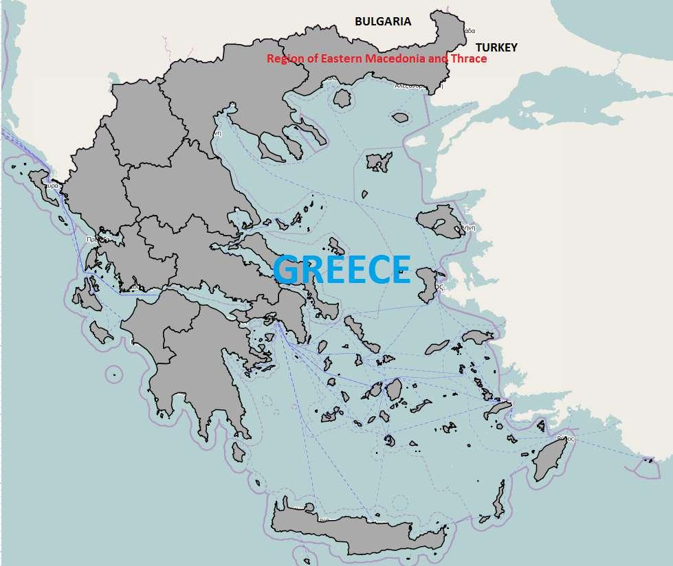
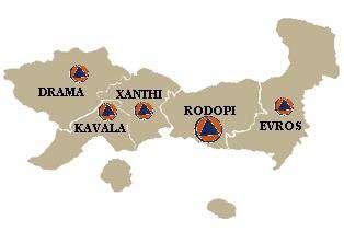
3 Case Study Area Regional Unit of Evros

4 Case Study Area Proposed Case Study Area limits Flood Hazard Zone Embankment Evros River

5
6 Authorities responsible for Flood Management. In National Level: Ministry of Environment and Energy Special Secretariat for Water. Ministry of Infrastructure, Transport and Networks Directorate of Flood Management and Land Reclamation Works. Ministry of Interior General Secretariat of Civil Protection. In Regional Level: Region of Eastern Macedonia and Thrace Regional Unit of Evros. Infrastructure authorities. Civil Protection authorities. Municipality of Soufli. Infrastructure authorities. Civil Protection authorities. Local Police and Fire Departments.

7 Main causes of flooding in Case Study Area: Evros River flooding. Stormwater flooding from streams vertical to Evros River.


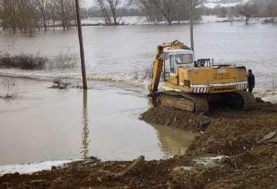
8 Evros River Mandra Stream


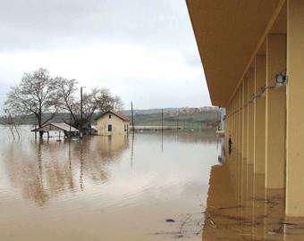
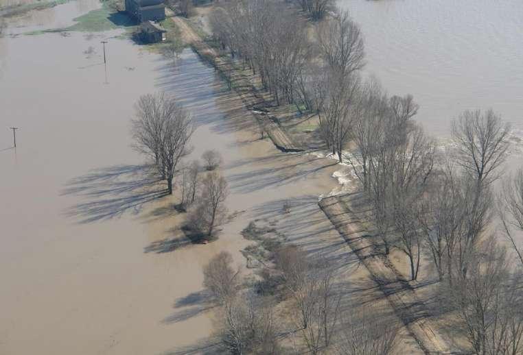
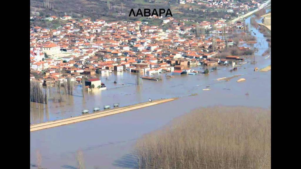
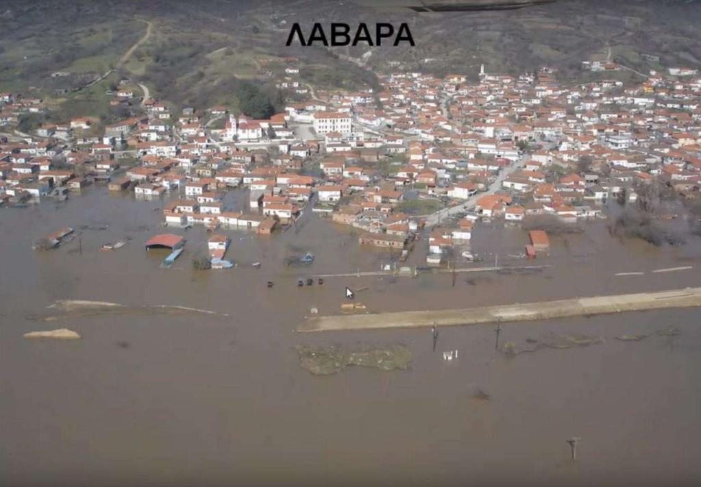
9 Lagina area flood 2010 Mandra area flood 2010 Pragi area flood 2010 Lavara area flood 2010


")
10 Bund break (caused by the water pressure) Bund break (caused by the water pressure) Bund break (caused by human intervention) Bund break (caused by human intervention)

11 2005

12 2005
13
14
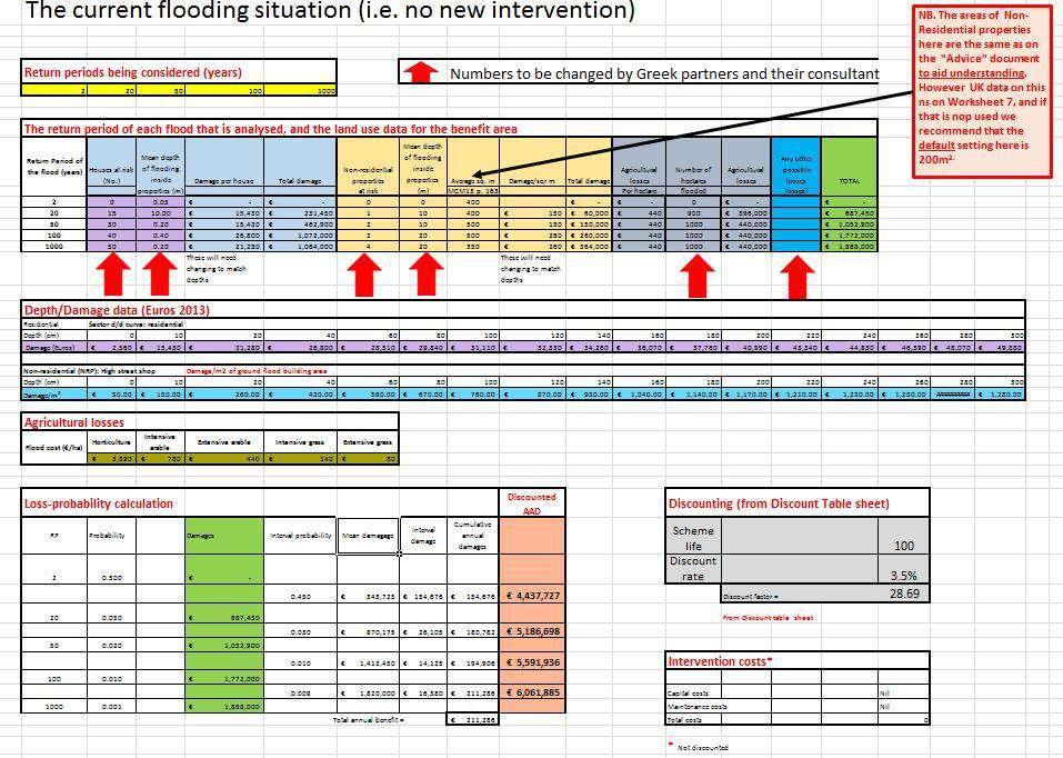
15 Flood History in the Study Area: Local District Population (2011) Number of flood events ( ) Amorio Lavara Mandra No human casualties Important Flood Events ( ): Event Date Local District Damaged Area (m ) Compensation ( ) 17/05/1998 Lavara ,00 01/05/2006 Amorio ,00 01/05/2006 Lavara ,00


16 Primary sectors affected by flood events: Agriculture. Livestock. Trade and Business. Transport Infrastructure. Properties (Public and Private). No archeological sites & monuments in Case Study Area. Damaged pump station Flooded area
17 Damages of Crops of the Lavara Area Year Area of SqrKhm Crop Cereals, Clover Cereals, Clover Cereals,Clover Cereals Cotton Sunflower Corn Clover Cereals Clover Cotton Corn Cereals, Clover Clover, Cereals

18 Evros River: Basin Area: km 2 66,2% in Bulgaria 27,5% in Turkey 6,3% in Greece River Length: 528 km Estimated flow (annual average): 103 m 3 /s


19 Copernicus Program flooded area satellite recordings


20 Flood Hazard Map by Return Period of 20 years


21 Flood Hazard Map by Return Period of 50 years


22 Flood Hazard Map by Return Period of 100 years

23 Flood Hazard Map by Return Period of 1000 years
24 Flood Depth per Return Period alongside the Railway and National Road Embankments Return Periods (years) Flood Depths alongside the Railway Embankment (m) > > >2.00
25 Current Flooding Situation - Damage estimations per Return Period Damage in buildings Return Periods (years) Residential Properties Non Residential Properties Damage in cultivated areas Return Periods (years) Area (ha)
26 Proposed flood protection interventions: 1. Closing of 3 National Road and Railway overpasses 2. Enhancing of the main by-pass channel in the irrigation network 3. Enhancing of the river s main embankment

27 1. Closing of 3 National Road and Railway overpasses: I. Overpass protection (2 Alternative Designs) II. Arrangement of the existing flood protection and drainage infrastructure Alternative A: Extended berms No land redistribution Construction of 3 berms Height: 4.00m Road Grade: ±7% Costs Value ( ) Capital Costs 300,000 Maintenance Costs 3,000 Total Costs 303,000 Alternative B: Shorter berms Land redistribution - expropriations

28 2. Closing of 3 National Road and Railway overpasses AND Enhancing of the main by-pass channel in the irrigation network Length: 12km Indicative depth: 3.00m Indicative bed width: 3.00m Indicative slope: 2:3 Costs Value ( ) Capital Costs 1,300,000 Maintenance Costs 13,000 Total Costs 1,313,000

29 3. Closing of 3 National Road and Railway overpasses AND Enhancing of the main by-pass channel in the irrigation network AND Enhancing of the river s main embankment Length: 16km Existing height: 3.00m Proposed height: 5.00m Proposed crest width: 6.00m Indicative slope: 2:3 Costs Value ( ) Capital Costs 2,600,000 Maintenance Costs 26,000 Total Costs 2,626,000
30
31 Current flooding situation: Discounted future potential losses: approx. 61,500,000 After Closing the 3 National Road and Railway overpasses: Total Cost: 303,000 Discounted future potential losses: approx. 855,000 Benefit: approx. 60,625,000 After Closing of 3 National Road and Railway overpasses AND Enhancing of the main by-pass channel in the irrigation network: Total Cost: 1,313,000 Discounted future potential losses: approx Benefit: approx. 60,915,000 After Closing of 3 National Road and Railway overpasses AND Enhancing of the main by-pass channel in the irrigation network AND Enhancing of the river s main embankment: Total Cost: 2,626,000 Discounted future potential losses: ø Benefit: approx. 61,500,000
32 CBA RESULTS Options (Repeated) Benefit : Cost ratio Benefit:cost ratios 1. Closing road and rail gaps Closing road and rail gaps AND Enhanced bypass channel in floodplain Closing road and rail gaps AND Enhanced bypass channel in floodplain AND Enhanced main river embankments Closing road and rail gaps 2. Closing road and rail gaps AND Enhanced bypass channel in floodplain 3. Closing road and rail gaps AND Enhanced bypass channel in floodplain AND Enhanced main river embankments
33 Thank you for your attention.
CITY COUNCIL AGENDA REPORT
 CITY COUNCIL AGENDA REPORT Subject: DESIGNATED FLOOD LINE CARROT CREEK Recommendation(s) That Administration bring forward a Land Use Bylaw amendment in October 2014 establishing the Designated Flood Line
Lilburn, GA STORMWATER BMP AND STREAM RESTORATION IN A CITY PARK. July 2013 Jill Stachura
 Lilburn, GA STORMWATER BMP AND STREAM RESTORATION IN A CITY PARK July 2013 Jill Stachura Project Location Gwinnett County, GA: Population: 825,000 Area: 437 sq. miles 1,300 miles storm drainage system
Jill Stachura STORMWATER BMP AND STREAM RESTORATION IN A CITY PARK. October 2013 Southeast Stormwater Association Annual Conference, Charlotte, NC
 Jill Stachura STORMWATER BMP AND STREAM RESTORATION IN A CITY PARK October 2013 Southeast Stormwater Association Annual Conference, Charlotte, NC Project Location Gwinnett County, GA: Population: 825,000
QUARRY REHABILITATION PLANS Specifications (version 1.3)
") For all our quarries, a rehabilitation plan must be developed from the outset. It is an integral part of the quarrying plan and provides for progressive and co-ordinated rehabilitation whenever possible.
For all our quarries, a rehabilitation plan must be developed from the outset. It is an integral part of the quarrying plan and provides for progressive and co-ordinated rehabilitation whenever possible.
Stormwater BMP and Stream Restoration in a City Park. Jeff Herr P.E., D.WRE Jill Stachura
 Stormwater BMP and Stream Restoration in a City Park Jeff Herr P.E., D.WRE Jill Stachura 770.673.3673 JHerr@BrwnCald.com Project Location Camp Creek in Metro Atlanta 7 sq. mile drainage area at project
7th Avenue Creek Master Plan Development Project. City of St. Charles, IL. IAFSM CONFERENCE March 14, 2018 MARKET
 7th Avenue Creek Master Plan Development Project MARKET City of St. Charles, IL IAFSM CONFERENCE March 14, 2018 7 TH AVENUE CREEK PROJECT AREA 2 2008 RAIN EVENT 3 RESIDENTIAL STRUCTURE FLOODING COMMERCIAL
ACE Geosynthetics. An Overview of
 ACE Geosynthetics An Overview of ACEGrid ACETex ACETube PRODUCT ACETex ACETex is the registered trademark of ACE Geosynthetics for all its geotextile products. ACETex is basically woven geotextile
PROJECT SCOPE OF WORK CITY OF TOWN AND COUNTRY STORMWATER PROGRAM
 PROJECT SCOPE OF WORK CITY OF TOWN AND COUNTRY STORMWATER PROGRAM Project ID Number: 25-5 Problem: Stormwater collected from the neighborhood upstream is released at 9 Muirfield Lane and flows west toward
CHAPTER 3 LAND USE, ZONING, AND DEVELOPMENT STANDARDS
 SEPTEMBER 3, 2013 CORDES RANCH SPECIFIC PLAN: TRACY, CALIFORNIA CHAPTER 3 LAND USE, ZONING, AND DEVELOPMENT STANDARDS 3.1 INTRODUCTION The Specific Plan Area is divided into four zoning districts: General
A G E N D A Council Update Training Room September 26, :45 p.m.
 CITY OF THORNTON CITY MANAGER S OFFICE A G E N D A Council Update Training Room September 26, 2017 5:45 p.m. A. Boards and Committees Reports (Estimated 20 Minutes) 1. Rangeview Library District Meeting
PROJECT SCOPE OF WORK CITY OF TOWN AND COUNTRY STORMWATER PROGRAM
 PROJECT SCOPE OF WORK CITY OF TOWN AND COUNTRY STORMWATER PROGRAM Project Name: 362 Featherstone Dr Project ID Number: 27-3 Problem: Anecdotal evidence suggests a natural spring exists in the backyard
NYC DEP s Approach to Flood Mitigation: The Local Flood Analysis (LFA) Process
 Process") NYC DEP s Approach to Flood Mitigation: The Local Flood Analysis (LFA) Process Milone & MacBroom, Inc. Jenabay Sezen, EIT Connecticut Association of Floodplain Managers October 25, 2016 Agenda Introduction
NYC DEP s Approach to Flood Mitigation: The Local Flood Analysis (LFA) Process Milone & MacBroom, Inc. Jenabay Sezen, EIT Connecticut Association of Floodplain Managers October 25, 2016 Agenda Introduction
River Kleine Nete : Creating ecological flooding zones at recreation areas
 Stoffel Moeskops Lange Kievitstraat 111-113 bus 64 B-2018 ANTWERPEN T +32 3 205 81 25 s.moeskops@vmm.be River Kleine Nete : Creating ecological flooding zones at recreation areas \\\\\\\\\\\\\\\\\\\\\\\\\\\\\\\\\\\\\\\\\\\\\\\\\\\\\\\\\\\\\\\\\\\\\\\\\\\\\\\\\\\\\\\\\\\\\\\\\\\\\\\
Vaughan Metropolitan Centre (VMC) Black Creek Renewal CLASS ENVIRONMENTAL ASSESSMENT
 Black Creek Renewal CLASS ENVIRONMENTAL ASSESSMENT") PUBLIC INFORMATION CENTRE Vaughan Metropolitan Centre (VMC) Black Creek Renewal Wednesday, May 10, 2017 6:00 p.m. to 8:00 p.m. Add photo Project Management, Environmental Assessment, Stormwater Management
PUBLIC INFORMATION CENTRE Vaughan Metropolitan Centre (VMC) Black Creek Renewal Wednesday, May 10, 2017 6:00 p.m. to 8:00 p.m. Add photo Project Management, Environmental Assessment, Stormwater Management
NAI Principles In Gwinnett County
 NAI Principles In Gwinnett County By Cornelius Ani, LSIT, CFM Contributors: Adena Fullard, P.E., CPSWQ Rudresh Bihalli, P.E., CFM Ken Kagy, P.E., CPESC, CPSWQ Ligia Negru, M. Sc., CFM Maja Radovic, CPESC,
PEOPLE S COMMITTEE OF HO CHI MINH CITY DEVELOPMENT STRATEGY FOR HO CHI MINH CITY S INFRASTRUCTURE
 PEOPLE S COMMITTEE OF HO CHI MINH CITY DEVELOPMENT STRATEGY FOR HO CHI MINH CITY S INFRASTRUCTURE Singapore, July 2012 1 GENERAL INFORMATION 2 GENERAL INFORMATION The centre for economics, culture, science
Case Study Presentation of the Downtown Brampton Flood Protection Class EA
 Case Study Presentation of the Downtown Brampton Flood Protection Class EA Presented by: Kenneth M. Dion, Project Director Port Lands Integration, Waterfront Toronto (formerly Senior Manager, TRCA) At:
SURREY COASTAL FLOOD ADAPTATION STRATEGY (CFAS) Phase 1 Open House
 Phase 1 Open House") SURREY COASTAL FLOOD ADAPTATION STRATEGY (CFAS) Phase 1 Open House CFAS Open House Photo Contest Winners #SurreyCoastal Activity Gail Stephan Under crescent beach pier. Great place to take a long exposure
SURREY COASTAL FLOOD ADAPTATION STRATEGY (CFAS) Phase 1 Open House CFAS Open House Photo Contest Winners #SurreyCoastal Activity Gail Stephan Under crescent beach pier. Great place to take a long exposure
City of Waco Stormwater Management Regulations
 1.0 Applicability: City of Waco Stormwater Management Regulations These regulations apply to all development within the limits of the City of Waco as well as to any subdivisions within the extra territorial
General rules of surface runoff generation and their application to urban areas
 Department of Irrigation, Drainage and Landscape Engineering Faculty of Civil Engineering Czech Technical University in Prague General rules of surface runoff generation and their application to urban
Construction Progress Report
 Report Date: 4/8/2017 Subject: Construction Week 2 70% Complete Project: Sunset Pond EWP Stream Reclamation, Fourmile Creek, Boulder County, CO Report By: TJ Burr, Civil Engineer/Stream Restoration Specialist,
Climate Change Adaptation Challenges seen from a Norwegian perspective
 Climate Change Adaptation Challenges seen from a Norwegian perspective Tartu, Estonia Tuesday May 19 th 2015 Kjell Harvold, Senior researcher Norwegian institute for Urban and Regional Research Main points
COMPANY PROFILE. Sellhorn Middle East Engineering
 COMPANY PROFILE Sellhorn Middle East Engineering Page 1/7 Our Business Activities Sellhorn Middle East s.a.r.l. [Sellhorn ME] is a consultancy practice for civil and structural engineering works. We are
Chapter 1: General Program Information
 Chapter 1: General Program Information 1.1 Introduction The Montgomery County Stormwater Management Resolution (#03-1-5) was adopted by the County Board of Commissioners on January 22, 2003. The purpose
BYLAW NO. 3549/2015. Being a Bylaw of The City of Red Deer to provide a uniform levy of off-site costs in respect of previously undeveloped land.
 BYLAW NO. 3549/2015 Being a Bylaw of The City of Red Deer to provide a uniform levy of off-site costs in respect of previously undeveloped land. 1 WHEREAS pursuant to provisions of Section 648 of the Municipal
6.1. INTRODUCTION 6.2. EXISTING CONDITIONS
 Chapter 6: Stormwater Management 6.1. INTRODUCTION This Chapter describes the current drainage patterns on the Project Site, the stormwater management system that is proposed as part of the Proposed Project,
Principles, Practices, and Tips for Water-Harvesting Earthworks and Rain Gardens
 Principles, Practices, and Tips for Water-Harvesting Earthworks and Rain Gardens by Brad Lancaster www.harvestingrainwater.com www.desertharvesters.org Abundance Scarcity sponge drain http://www.smgov.net/departments/ose/categories/content.aspx?id=4082
KYTC and NFIP: Bridging Floodplain Management and Design KAMM CONFERENCE AUGUST 25, 2015
 KYTC and NFIP: Bridging Floodplain Management and Design KAMM CONFERENCE AUGUST 25, 2015 KYTC STATEWIDE DRAINAGE DESIGN Provide Drainage Design Services on an as needed basis: Perform hydraulic analysis
STORMWATER UTILITY FREQUENTLY ASKED QUESTIONS
 STORMWATER UTILITY FREQUENTLY ASKED QUESTIONS What is Stormwater? Stormwater is water that falls to the ground during a precipitation event. When land is undeveloped or covered with vegetative surface,
In Title Your Area 10: Lower Boddington to Southam & Offchurch
 LOCAL AREA In Title Your Area 10: Lower Boddington to Southam & Offchurch Find out here about: what is proposed between Lower Boddington and Southam & Offchurch; what this means for people living between
4.6. Low Impact and Retentive Grading
 4.6. Low Impact and Retentive Grading Low Impact Grading techniques focus on utilizing existing topography during Site layout to minimize cost. Proposing structures, roads, and other impervious surfaces
Sustainable Storm Water Management
 Incorporating Water Management into the Community Planning Process August 16, 2012 Sustainable Storm Water Management Samantha Brown Environmental Engineer SD1 SD1 s Service Area CVG Airport SD1 Service
Balancing Conservation and Development on the Jordan River
 Balancing Conservation and Development on the Jordan River Jordan River Parkway Trail Regional Athletic Complex Conservation & Restoration Balancing Conservation and Development on the Jordan River Jordan
Connecting Master Plans, Asset Management, and CIP s to Bolster Economic Development
 Connecting Master Plans, Asset Management, and CIP s to Bolster Economic Development Presented By Paul Montagno, AICP, Carlisle Wartman Associates And Terry Moultane, AICP, Bay City What We re Covering
Witteveen+Bos. Strategy // Planning // Design for resilient urban places. Rachael Cox April 2017
 Healthy Witteveen+Bos: & Resilient Cities: Designing Urban Healthy Planning & and Resilient Engineering Cities 1 Witteveen+Bos Strategy // Planning // Design for resilient urban places Rachael Cox April
South Bismarck Watershed Model Update and Stormwater Improvement Project
 Preliminary Engineering Report Bismarck Tribune South Bismarck Watershed Model Update and Stormwater Improvement Project City of Bismarck, ND January 2017 14.105.0046 1.0 Executive Summary The focus of
Site Option 3: Te Matai
 Site Option 3: Te Matai Location Napier Drain looking south east Description The Te Matai growth option is located between the existing residential boundary (Ruamahanga Crescent) Napier Road (State Highway
Dor Havkin. Founder, Dor Havkin ECO-STRATEGIS, sustainable development & green building, consultancy & design (Since 2003)
") Dor Havkin Current positions Founder, Dor Havkin ECO-STRATEGIS, sustainable development & green building, consultancy & design (Since 2003) Director of ecological development, Eco & Sustainable Tourism
Dor Havkin Current positions Founder, Dor Havkin ECO-STRATEGIS, sustainable development & green building, consultancy & design (Since 2003) Director of ecological development, Eco & Sustainable Tourism
Vegetated Filter Strips and Buffers
 3.15 Sediment Control Description: Buffer strips (existing vegetation) and filter strips (planted vegetation) are sections of vegetated land adjacent to disturbed areas. They are designed with low slopes
Imperviousness & Runoff
 North Texas Alternative Futures Imperviousness & Runoff A key indicator for comparing alternative future scenarios This powerpoint presents: What is this key indicator? How do the alternative future scenarios
Brigitte A. Berger, Director of Engineering
 Brigitte A. Berger, Director of Engineering Wilmette s Sewer System Overview of Wilmette s Sewer System Green vs. Gray? Stormwater Action Plan Regulatory Compliance Why Homes Flood What can
WELCOME! 8 8:30 6: TH STREET IMPROVEMENTS. Open House. Presentation & Q&A
 WELCOME! 168 TH STREET IMPROVEMENTS 6:30 Open House 7 8 Presentation & Q&A 8 8:30 Open House WELCOME Todd Pfitzer City of Omaha Engineer Bob Stubbe City of Omaha Public Works Director Jon Meyer Project
Vegetated Filter Strips and Buffers
 3.15 Sediment Control Description: Buffer strips (existing vegetation) and filter strips (planted vegetation) are sections of vegetated land adjacent to disturbed areas. They are designed with low slopes
MINISTRY OF THE INTERIOR CHIEF-DIRECTORATE FIRE SAFETY AND CIVIL PROTECTION DISASTERS RESPONSE AND UNIFIED RESCUE SYSTEM
 MINISTRY OF THE INTERIOR CHIEF-DIRECTORATE FIRE SAFETY AND CIVIL PROTECTION DISASTERS RESPONSE AND UNIFIED RESCUE SYSTEM LAW ON THE MoI CHIEF DIRECTORATE FIRE SAFETY AND CIVIL PROTECTION - MoI With the
WWF International Danube-Carpathian Programme is seeking to contract an
 WWF International Danube-Carpathian Programme is seeking to contract an Expert in transport infrastructure development and implications with nature conservation Within the framework of the project TRANSGREEN
International Green Roof City Network Case Study Seoul, Republic of Korea
 International Green Roof City Network Case Study Seoul, Republic of Korea 1) City Data Location Seoul is located in the central part of Korean peninsular. Seoul city was the newly planned capital city
Stream Corridor Management Plan
 Stream Corridor Management Plan A unified and comprehensive approach to protecting, restoring and managing the Upper Delaware River Graydon Dutcher Delaware County Soil and Water Conservation District
Lower Meramec Multi-Jurisdictional Floodplain Management Plan Public Involvement (Results of Early Public Engagement) 27 June 2018
 27 June 2018") Lower Meramec Multi-Jurisdictional Floodplain Management Plan Public Involvement (Results of Early Public Engagement) 27 June 2018 Public Involvement Summary: The planning process includes opportunities
Lower Meramec Multi-Jurisdictional Floodplain Management Plan Public Involvement (Results of Early Public Engagement) 27 June 2018 Public Involvement Summary: The planning process includes opportunities
Feasibility study for new foot/cycle bridge across the River Tillingham
 Feasibility study for new foot/cycle bridge across the River Tillingham 1. Why is a bridge needed? Currently all residents of Tilling Green and Valley Park can only get into Rye via the Ferry Road / Udimore
Beyond Rain Gardens Advancing the Use of Compost for Green Infrastructure, Low Impact Development, & Stormwater Management
 Beyond Rain Gardens Advancing the Use of Compost for Green Infrastructure, Low Impact Development, & Stormwater Management VORS 2018 Stormwater Management Session 2 Stormwater Management, Green Infrastructure,
Stormwater Master Plan Update. City Council Briefing January 8, 2019
 Stormwater Master Plan Update City Council Briefing January 8, 2019 1 Stormwater Master Plan Update January 8, 2019 Agenda Background for Update Stormwater Modeling and Calibration Visualizations of Results
Retrofitting Sacramento State Campus with Low Impact Development Stormwater Control Measures: A Local Project with Regional Intent
 Retrofitting Sacramento State Campus with Low Impact Development Stormwater Control Measures: A Local Project with Regional Intent Kevin Murphy, P.E. Joel Shinneman, EIT OWP at Sacramento State 1 Project
Shift Rapid Transit Public Participation Meeting May 3, 2017
 Shift Rapid Transit Public Participation Meeting May 3, 2017 Shift Rapid Transit Initiative Largest infrastructure project in the city s history. Rapid Transit initiative will transform London s public
TENDER. Subject of the tender: Field-work on verification of ecological corridors
 TENDER CEEweb for Biodiversity (1021 Budapest, Széher út 40., Hungary, registration no. 1634) makes this Tender for consulting services to be completed by 1/September/2018, to be started in September 2017.
Zoning Ordinance Chapter 10
 CHAPTER 10 - WASHES SECTION 10.0 GENERAL: A. The purpose of this Ordinance is to establish standards for development in or near Major and Minor Washes as defined in Appendix A Glossary of Terms and Definitions
Inventory and Assessment of Stormwater Infrastructure
 Inventory and Assessment of Stormwater Infrastructure Identifying and Assessing Stormwater Infrastructure Before an assessment can be completed, stormwater infrastructure must be located and identified
Section 1 TABLE OF CONTENTS
 Section 1 TABLE OF CONTENTS... [M]ineral fertilizer is essential to feed around half of the world s population, and will be fundamental to ensure global food security through the 21 st century. 2013 U.N.
I. INTRODUCTION. identify long-term capital improvements and rehabilitation measures for the existing drainage system;
 I. INTRODUCTION The Town of Windsor, Colorado is presently experiencing rapid growth and development within the boundaries of several of its major drainage basins. As growth continues within these basins,
BERNALILLO COUNTY PLANNING COMMISSION ENVIRONMENT AND OPEN SPACE HEARING MAY 2014
 BERNALILLO COUNTY PLANNING COMMISSION ENVIRONMENT AND OPEN SPACE HEARING MAY 2014 1 PROJECT DEVELOPMENT TEAM: Garrett Development Corporation Bohannan Huston Inc. SEC Planning, LLC Consensus Planning,
Northeast Anthony Henday Drive Manning Freeway to Whitemud Drive Welcome to this Construction Information Session
 Manning Freeway to Whitemud Drive Welcome to this Construction Information Session Purpose To inform interested residents and businesses about the plans accommodation. Background: The Government of Alberta
Evaluation of How O&M Costs Vary for Alternative Flood Control Strategies
 Evaluation of How O&M Costs Vary for Alternative Flood Control Strategies Fargo-Moorhead Diversion Channel ASFPM Conference June 13, 2013 Matt Redington, PE Jeremy Cook HDR Engineering Red River of the
DANUBE FLOODPLAIN PROJECT. 11 th EUSDR PA4 Steering Group Meeting
 DANUBE FLOODPLAIN PROJECT 11 th EUSDR PA4 Steering Group Meeting 25.05.2016 Background: Danube Floodplain project is highlighted in: Danube Declaration 2016 adopted by Danube Ministers, DRBMP, DFRMP Flagship
Stormwater Regulations & Considerations Morse Study Area. Pam Fortun, P.E. CFM Senior Stormwater Treatment Engineer Engineering Services Division
 Stormwater Regulations & Considerations Morse Study Area Pam Fortun, P.E. CFM Senior Stormwater Treatment Engineer Engineering Services Division Stormwater Regulations Development Considerations Floodplain
NORTH WEST SECTOR HORLEY, SURREY
 Welcome to our Exhibition We are delighted to present our plans for the first phase of the North-West Sector Horley development. We are holding this exhibition to give you the chance to view and comment
Structural Project (stream daylighting) Property Protection (elevation) PREVENTION NATURAL RESOURCE PROTECTION STRUCTURAL PROJECTS PUBLIC EDUCATION
 Property Protection (elevation) PREVENTION NATURAL RESOURCE PROTECTION STRUCTURAL PROJECTS PUBLIC EDUCATION") NEW MITIGATION GOALS, STRATEGIES, ACTIONS PREVENTION STRUCTURAL PROJECTS NATURAL RESOURCE Structural Project (stream daylighting) PROPERTY PUBLIC EDUCATION EMERGENCY SERVICES Property Protection (elevation)
NEW MITIGATION GOALS, STRATEGIES, ACTIONS PREVENTION STRUCTURAL PROJECTS NATURAL RESOURCE Structural Project (stream daylighting) PROPERTY PUBLIC EDUCATION EMERGENCY SERVICES Property Protection (elevation)
Why a new Food & Farm Ordinance?
 Growing for Kane Why a new Food & Farm Ordinance? 1. Growing obesity issue 64% of Kane adults are overweight or obese 2. Low rates of fruit & vegetable consumption Healthy diets include more fruits & veggies.
City of Hume Planning Scheme Amendment C207. Statement of Expert Evidence Provided to Planning Panels Victoria
 14 August 2017 Revision: 1 Reference: 1702 City of Hume Planning Scheme Amendment C207 Statement of Expert Evidence Provided to Planning Panels Victoria Stormwater Management Evidence for 35 Buckland Way
GRACE CHURCH EXPANSION
 GRACE CHURCH EXPANSION REVIEW: NOVEMBER 24, 2014 200 SAGE ROAD, CHAPEL HILL NORTH CAROLINA PROJECT DATA OVERALL SITE MAP SITE INFORMATION OWNER PIN ACREAGE VICINITY MAP GRACE CHURCH 9890503171 271,600
Natomas Joint Vision Open Space Plan
 Natomas Joint Vision Open Space Plan First Workshop series The City of Sacramento The County of Sacramento LAFCo ERA Economic Research Associates EIP Associates a Division of PBS & J Natomas Joint Vision
Regional Development / CBC Environment Bulgaria - Greece Border Region. Contracting deadline: 30/11/2008 Execution of contract deadline: 30/11/2011
 Cross border co-operation between Bulgaria and Greece Project Fiche on Tourist Centre Perpericon" ( Priority ) Promotion of cultural and tourist resources. Basic nformation CRS Number: BG /8-8.. Title:
Public Information Centre # 2 Coronation Park Drainage Improvements Town of Oakville Municipal Class Environmental Assessment
 November 26, 2014 Public Information Centre # 2 Coronation Park Drainage Improvements Town of Oakville Municipal Class Environmental Assessment Study Area & Drainage System Legend Coronation Project Park
ORDINANCE NUMBER DRAFT. An ordinance amending Title 12 Environmental Protection of the Los Angeles County
 ORDINANCE NUMBER DRAFT 1 1 1 1 1 1 0 1 An ordinance amending Title 1 Environmental Protection of the Los Angeles County Code, establishing Low Impact Development standards. The Board of Supervisors of
BOARD OF ADVISORS Biographies
 BOARD OF ADVISORS Biographies Sheila Boudreau, Senior Landscape Architect, Special Projects and Design Services, Toronto and Region Conservation Authority Sheila Boudreau is a registered landscape architect
Project Narrative For Fruita RV Resort Conditional Use Permit
 Project Narrative For Fruita RV Resort Conditional Use Permit Date: November 18, 2016 Prepared by: Robert W. Jones, II, P.E. Vortex Engineering & Architecture, Inc. 2394 Patterson Rd., Ste. 201 Grand Junction,
LIFE RINASCE - Naturalistic Restoration for the integrated hydraulic-environmental Sustainability of the Emilian Canals LIFE13 ENV/IT/000169
 LIFE RINASCE - Naturalistic Restoration for the integrated hydraulic-environmental Sustainability of the Emilian Canals LIFE13 ENV/IT/000169 Project description Environmental issues Beneficiaries Administrative
DC Clean Rivers Project Green Infrastructure Program
 District of Columbia Water and Sewer Authority George S. Hawkins, General Manager Briefing on: DC Clean Rivers Project Green Infrastructure Program Briefing for: American Water Resources Association National
Unique ID: (from PFRA database) Location: Tralee, Co. Kerry. Stage 1: Desktop Review
 Location: Tralee, Co. Kerry. Stage 1: Desktop Review") Location: Tralee, Co. Kerry Unique ID: 230361 (from PFRA database) Initial OPW Designation APSR AFRR IRR Co-ordinates Easting: 82750 Northing: 114000 River / Catchment / Sub-catchment Lee River & Big River/
Location: Tralee, Co. Kerry Unique ID: 230361 (from PFRA database) Initial OPW Designation APSR AFRR IRR Co-ordinates Easting: 82750 Northing: 114000 River / Catchment / Sub-catchment Lee River & Big River/
14.5 HOPEFIELD: (REFER PLAN 39 AND PLAN 40)
") URBAN DYNAMICS WESTERN CAPE INC. 248 14.5 HOPEFIELD: (REFER PLAN 39 AND PLAN 40) FIGURE 83: LOCALITY - HOPEFIELD Within the context of the Saldanha Bay Municipal area, Hopefield, an historical agricultural
URBAN DYNAMICS WESTERN CAPE INC. 248 14.5 HOPEFIELD: (REFER PLAN 39 AND PLAN 40) FIGURE 83: LOCALITY - HOPEFIELD Within the context of the Saldanha Bay Municipal area, Hopefield, an historical agricultural
Fluvial non-tidal Fluvial tidal Coastal. PFRA database comments (in italics): OPW comments Minor flooding of residents on golf links road
: OPW comments Minor flooding of residents on golf links road") Location: Charleville, Co. Cork Unique ID: 240375 (from PFRA database) Initial OPW Designation APSR AFRR IRR Co-ordinates Easting: 152250 Northing: 122500 River / Catchment / Sub-catchment Glen River /
Location: Charleville, Co. Cork Unique ID: 240375 (from PFRA database) Initial OPW Designation APSR AFRR IRR Co-ordinates Easting: 152250 Northing: 122500 River / Catchment / Sub-catchment Glen River /
Energy Efficient Strategies for Urban Transportation Planning
 EinT2018 3 rd International Conference ENERGY in TRANSPORTATION 2018 Energy Efficient Strategies for Urban Transportation Planning Prof. Dr. Doaa M. El-Sherif, PhD, Arch. Email: doaa_elsherif@yahoo.com
West Little Pimmit Storm Sewer & John Marshall Green Street Projects. July 7, 2015 Nottingham Elementary School
 West Little Pimmit Storm Sewer & John Marshall Green Street Projects July 7, 2015 Nottingham Elementary School Project Timeline February 2015: Archeological study of island, including historic spring location,
Toronto Complete Streets Guidelines
 Toronto Complete Streets Guidelines 108 110 7.1 Green Infrastructure Design Principles 112 7.2 Context-Sensitive Green Streets 114 7.3 Key Green Street Elements Green infrastructure refers to natural and
Checklists. Project Name: Location: File Number: Date of Submittal: Reviewer: Date: Applicant: Contact Name: Phone Number:
 Applicant: Contact Name: Phone Number: Email: Project Name: Location: File Number: Date of Submittal: Reviewer: Date: Concept Plan Requirements: I. General Project Information 1. Address or parcel number
Surrey Ecosystem Management Study
 Surrey Ecosystem Management Study Green Infrastructure Network Opportunities Public Open House & Information Session June 24 th, 2010 EMS Process Ecological Inventory Ecological Assessment Management Policy
PUBLIC SERVICES ELEMENT GOALS / POLICIES / MEASURES
 PUBLIC SERVICES ELEMENT GOALS / POLICIES GOALS / POLICIES / MEASURES Authority The Public Services Element addresses provision of municipal services to City residents. The following paragraphs provide
City of Elmhurst. City of Elmhurst. Storm Sewer System Workshop November 22, 2010
 City of Elmhurst City of Elmhurst Storm Sewer System Workshop November 22, 2010 1 City of Elmhurst Watershed divide (green dashed line) through Elmhurst Area east of divide drains to Addison Creek Area
Introduction. Public Information Package. Project website. Overview. Class Environmental Assessment Process
 1 Introduction Public Information Package Baseline Road Extension between Lambs Road and Bennett Road, Bowmanville Schedule B Municipal Class Environmental Assessment November 6, 2017 Overview The purpose
Green Infrastructure Program Updates
 Metropolitan Water Reclamation District of Greater Chicago Green Infrastructure Program Updates Calumet Stormwater Collaborative June 1, 2018 - Chicago Stormwater Management Programs Flooding remains our
Stormwater Management Techniques WMPF LAND USE TRAINING INSTITUTE MARCH 14, 2018
 Stormwater Management Techniques WMPF LAND USE TRAINING INSTITUTE MARCH 14, 2018 Potential Impacts of New Development Urban development can significantly increase stormwater runoff Water quality considerations
DRR in URBAN PLANNING PROCESS in ISTANBUL
 DRR in URBAN PLANNING PROCESS in ISTANBUL Geomatic Engineer, MSc. Emin Yahya MENTEŞE Directorate of Earthquake & Ground Analysis ISTANBUL-Some facts Housing more than 15 million inhabitants Most crowded
Washington County, Maryland Division of Public Works Policy Manual
 Washington County, Maryland Division of Public Works Policy Manual Subject: Downstream Drainage Easement Category: Land Development Engineering Number: 7-4.1 Date: June 1, 2009 (effective) PURPOSE: The
B - Coalfield River Corridor Landscape Character Type
 B - Coalfield River Corridor Landscape Character Type Landscape Character Type - Coalfield River Corridor The Coalfield River Corridors Landscape Character Type is located in the two converging valleys
Unique ID: (from PFRA database) Location: Birr, Co. Offaly. Stage 1: Desktop Review
 Location: Birr, Co. Offaly. Stage 1: Desktop Review") Location: Birr, Co. Offaly Unique ID: 250410 (from PFRA database) Initial OPW Designation APSR AFRR IRR Co-ordinates Easting: 206,007 Northing: 204,990 River / Catchment / Sub-catchment Camcor River /
Location: Birr, Co. Offaly Unique ID: 250410 (from PFRA database) Initial OPW Designation APSR AFRR IRR Co-ordinates Easting: 206,007 Northing: 204,990 River / Catchment / Sub-catchment Camcor River /
Outflow to Saw Mill Run
 Dormont Stormwater Fee Frequently Asked Questions What is stormwater, and why is it a problem in Dormont? Stormwater is runoff from rain or snow that falls and flows to Little Saw Mill Run or McNeilly
PRESENTATION ON JOHANNESBURG S BIODIVERSITY PROGRAMME
 PRESENTATION ON JOHANNESBURG S BIODIVERSITY PROGRAMME Member of Mayoral Committee: Cllr Prema Naidoo Environmental Management & Johannesburg City Parks PRESENTATION OVERVIEW Jo burg Overview & Context
Low Impact Development for your homes, businesses & streets
 Low Impact Development for your homes, businesses & streets What s the problem anyways? - Development Impacts the Water Cycle In the past, our main pollution concern was Point Source Pollution Our current
Social Screening and Impact Assessment for Sub Projects
 Social Screening and Impact Assessment for Sub Projects Code No: 7 A. Sub Project Description: Rehabilitation of McCallum Lock Gates and Construction of Bank Protection Wall with Linear Walk Around Beira
FINAL. Appendix A: Figure Viewpoint 1 View from Nurragingy Reserve (North) Proposed Modification to RDC, Rooty Hill
 Proposed Modification to RDC, Rooty Hill") Viewpoint 1 Existing View from Nurragingy Reserve (North) Photo taken 01/06/2010-11:45am - (facing Southwest) Outline of Proposed Storage Bins and Noise Wall Viewpoint 1 Proposed View from Nurragingy Reserve
Viewpoint 1 Existing View from Nurragingy Reserve (North) Photo taken 01/06/2010-11:45am - (facing Southwest) Outline of Proposed Storage Bins and Noise Wall Viewpoint 1 Proposed View from Nurragingy Reserve
WGF18 Workshop Spatial Planning Questionnaires
 sig.magrama.es/snczi WGF18 Workshop Spatial Planning Questionnaires F. Javier Sánchez Martínez Tordesillas (Valladolid) 1. Objectives of questionnaire To know the situation of the land use policy regarding
Billing Code: DEPARTMENT OF HOUSING AND URBAN DEVELOPMENT [Docket No. FR-6072-N-01]
![Billing Code: DEPARTMENT OF HOUSING AND URBAN DEVELOPMENT [Docket No. FR-6072-N-01]](/thumbs/91/107309814.jpg "Billing Code: DEPARTMENT OF HOUSING AND URBAN DEVELOPMENT [Docket No. FR-6072-N-01]") This document is scheduled to be published in the Federal Register on 12/18/2017 and available online at https://federalregister.gov/d/2017-27194, and on FDsys.gov Billing Code: 4210-67 DEPARTMENT OF HOUSING
This document is scheduled to be published in the Federal Register on 12/18/2017 and available online at https://federalregister.gov/d/2017-27194, and on FDsys.gov Billing Code: 4210-67 DEPARTMENT OF HOUSING