Howard W. Peak Greenway Trails
|
|
|
- Felix McBride
- 5 years ago
- Views:
Transcription


1 Howard W. Peak Greenway Trails
2 Program Beginnings Mayor Howard Peak and other Council members initiated and supported idea of creating linear parks along San Antonio creekways Program plan was developed, focused around San Antonio River, Salado Creek and Leon Creek City initiated sales tax initiative to fund Linear Creekway Parks and Edwards Aquifer programs in 1999 (Local Government Code, Chapter 334 Sports and Community Venues) voters approved in 2000


3 Program Mission & Goals Mission: Goals: To enhance the quality of life for San Antonio residents and visitors Expand recreational opportunities Preserve open space and riparian connectivity for wildlife habitat Install building blocks for comprehensive system of pedestrian and bicycle connectivity Increase effectiveness of stormwater management
4 Program Funding Sales Tax Revenue (1/8 cent) $110m Proposition 3 (2000) - $20m Proposition 2 (2005) - $45m Proposition 2 (2010) - $45m Project funds expended as sales tax revenue is collected (No debt issuance) Transportation Efficiency Act (TEA-21) - $4m 1999 Bond Funds - $800k 2003 Bond Funds $1.3m TOTAL FUNDING TO DATE ~ $116,000,000 (TxDOT Wurzbach Parkway funding not included)


5 Current Trails Program Completed and Funded Projects include approx. 86 miles along: - Leon Creek - Salado Creek - Medina River - Westside Creeks - Other waterways 5


 8.")
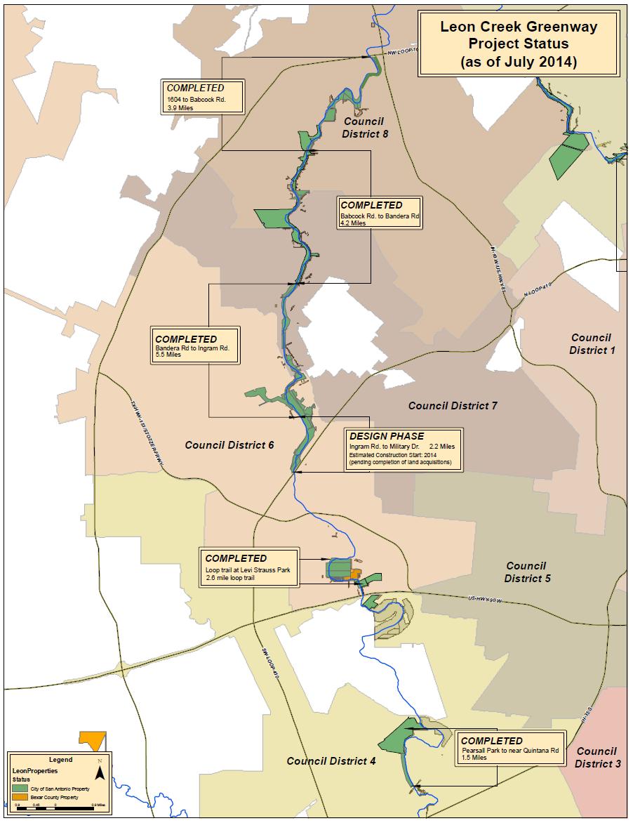
6 Ultimate Trails System Future projects necessary to complete connected ring around San Antonio: Leon Creek - Pearsall Park to Medina River 12.4 miles - Lackland AFB 5.2 miles - Military Dr. to Rodriguez Park 2.4 miles Salado Creek to San Antonio River (SE side) 8.3 miles Westside Creeks 4.1 miles TOTAL estimated distance miles 6
7
8
9
10 Current Project Status Over 1200 acres of Creekways Property acquired to date 46 miles of trail completed to date Salado Creek 22 miles Leon Creek 17 miles Medina River 7 miles 11 miles of trail under construction Salado Creek - TxDOT 2.4 miles Huebner Creek 1.2 miles Olmos Creek -.9 miles Medina River 6.5 miles Approximately 16 miles of trail under design Leon Creek (Ingram to Military) 2.2 miles Culebra Creek 2.5 miles Huesta Creek 1.2 mile Westside Creeks 6.2 miles Salado (Ft. Sam connection) miles
11 Ongoing Project Coordination Efforts COSA Transportation and Capital Improvements Department (TCI) Contracts, Project Coordination, Stormwater Operations, etc. COSA Office of Sustainability - Bike Master Plan update COSA Intergovernmental Relations Federal Interface Alamo Area MPO Planning, BMAC, PMAC and TIP Bexar County Flood Control Program SAWS co-use of easements & trails CPS co-use of easements & trails VIA transit-trail connections SARA Westside Creeks trails and restoration planning SA2020 Coordination of Parks and Greenspace Initiatives TxDOT Construction and Maintenance Agreements

12 The Ugly: 2000

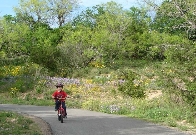
13 The Bad: 2004

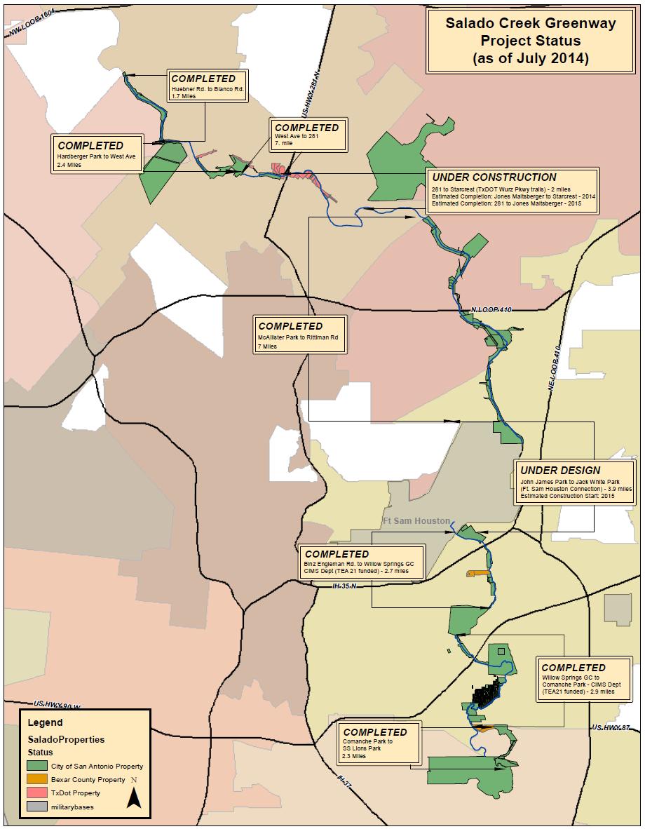
14 The Good: 2012

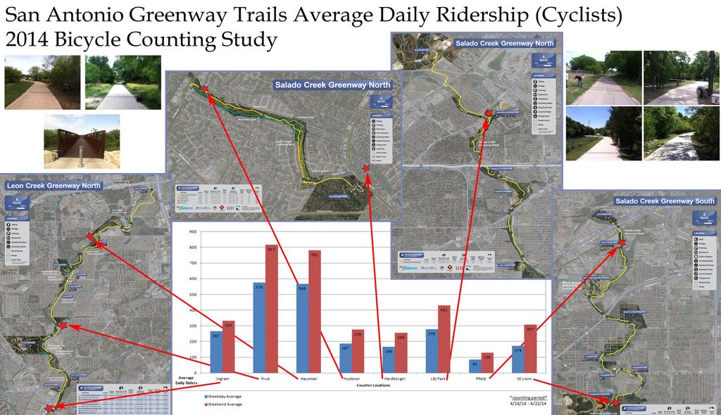
15 Office of Sustainability Bike Counts
16 Greenway System Management Public Safety Bike & ATV patrol Trail Stewards Trail Watch Volunteers Parks Maintenance Initial cleanup (before & during construction) Ongoing trail and park land maintenance Stormwater Operations Ongoing removal of trash and woody debris (5 year cycle)


17 Trail Patrol (multi-level) Park Police provide law enforcement function and distribute materials at City, school, and community events The Trail Steward Program has been expanded with the mission of assisting and educating the public on the greenways Volunteer Trail Patrol Program modeled after the Neighborhood Watch Program (in collaboration with Park Police) 17
 2) Trail Etiquette - September 20 roll-out (Hardberger at")

18 Trail Safety and Etiquette Campaigns Two Phases: 1) Trail Safety Rolled out beginning June 7 (National Trails Day) 2) Trail Etiquette - September 20 roll-out (Hardberger at 10am) Promotional items at Parks and Recreation Events Media - Social Media, Radio, TV, B-Cycle station postings, etc. Coordination with SARA on San Antonio River Trails 18

19 Trail Safety/Etiquette Signage Be Courteous, Share the Trail signage at trailheads Stay Right, Pass on Left. Bikes Yield to Pedestrians has been placed at signs installed along the trails Center stripe and Caution/Slow Down signage at blind curves Warning signage as appropriate ( Trail Narrows and Creek Crossing Ahead for example). Incorporation of signage into new trail projects 19
20 Other Trail Safety/Etiquette Items Trail shoulder mowing has been expanded from 2-ft to 4-ft 911 Locator added to mile and quarter mile markers Associated coordination with ITSD/SAFD for 911 dispatch system. Interactive Greenway Companion for children Office of Sustainability 20

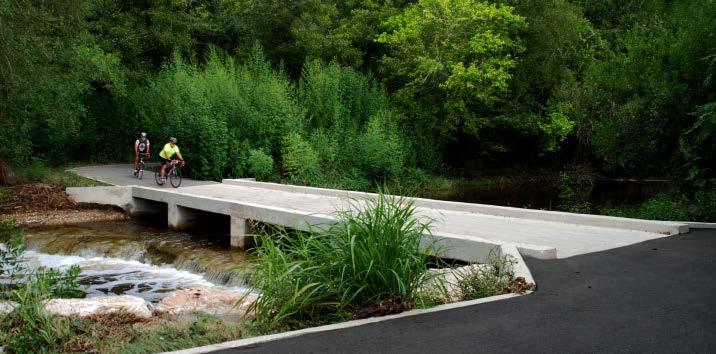
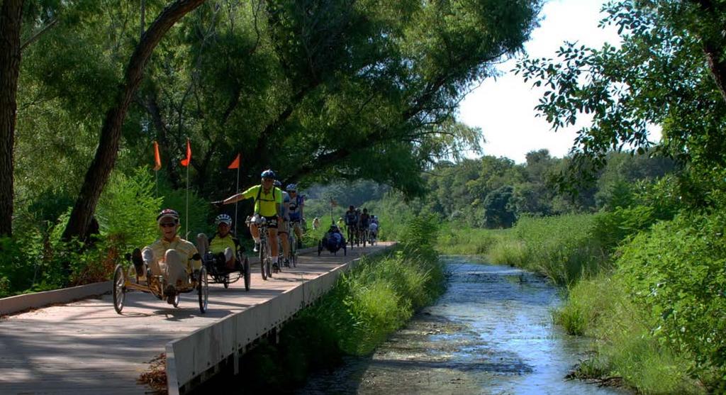
21 Leon Creek Greenway

22 Salado Creek Greenway

23 Salado Creek Greenway

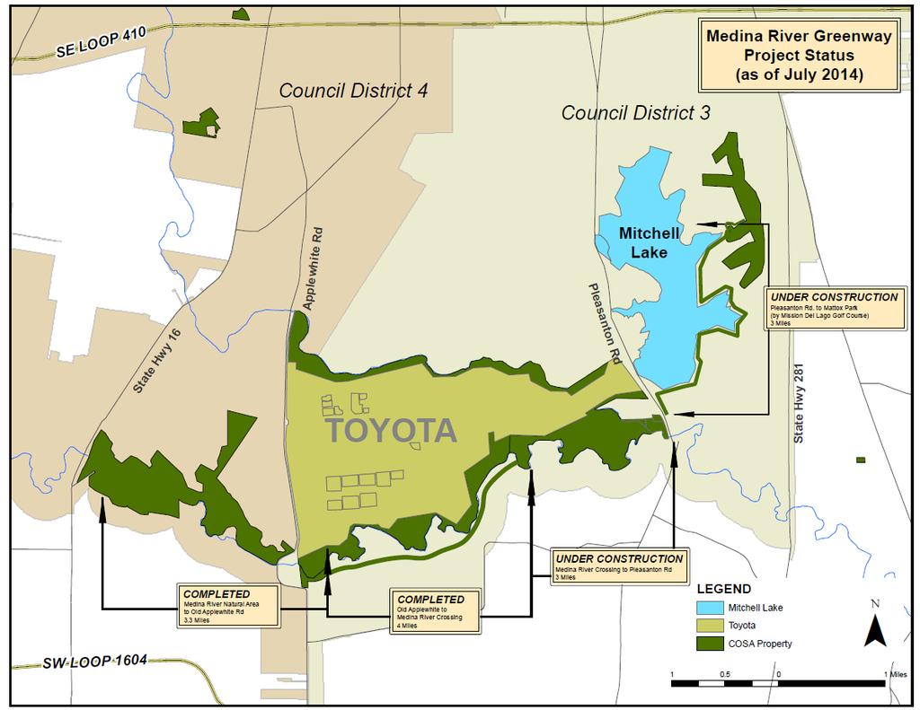
24 Medina River Greenway

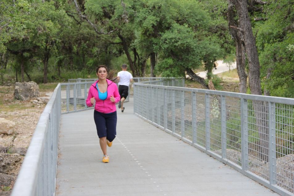
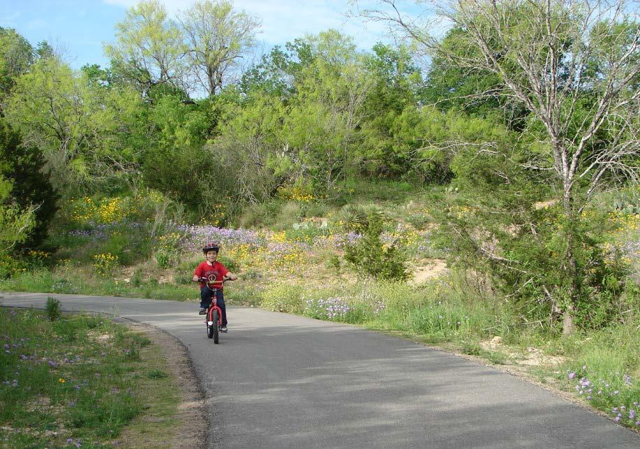
25 Leon Creek Greenway

26 Leon Creek Greenway
27 Leon Creek Greenway
2011 ASLA Design Awards. Westside Creeks Restoration Plan Merit Award AECOM, Fort Collins. Planning & Urban Design
 2011 ASLA Design Awards Westside Creeks Restoration Plan Merit Award AECOM, Fort Collins Planning & Urban Design Project Fact Sheet Category of Entry: Rotating Specialty Award: 2011 2011 ASLA Colorado
G. RECREATION AND OPEN SPACE ELEMENT. The following summarizes the Recreation and Open Space Element:
 G. RECREATION AND OPEN SPACE ELEMENT The purpose of the Element is to provide the framework and direction for a comprehensive system of public and private sites for recreation, including, but not limited
The following principles guide the development of goals and strategies to protect and promote these amenities:
 OPEN SPACE/PARKS/TRAILS/RECREATION GOALS/STRATEGIES Cherry Hills Village is a living environment that offers low density development, open areas, public scenic vistas, public trails and public parks. This
Yadkin River Greenway Feasibility Study Fact Sheet Village of Clemmons, Town of Lewisville, Town of Bermuda Run
 Fact Sheet Village of Clemmons, Town of Lewisville, Town of Bermuda Run Project Background The Yadkin River Greenway Feasibility Study is a joint project with the Village of Clemmons, the Town of Bermuda
Green Infrastructure The Indianapolis Greenways Connection
 Green Infrastructure The Indianapolis Greenways Connection Fewer things in the transportation industry today make better since than combining the needs for pedestrian and bike trails with the need to locate,
Parks, Trails, and Open space Element
 Parks, Trails, and Open space Element Parks, Trails, and Open Space element Parks, Recreation, and Open Space are important components of the quality of life desired by the residents of Elk Grove. This
13 Maintenance and Operations Plan 223
 222 13 Operations Maintenance and Plan 223 Chapter 13 MAINTENANCE AND OPERATIONS PLAN 13.1 Stewardship The Minneapolis Park and Recreation Board (MPRB) is the steward of a nationally-acclaimed park system.
City of Missoula and Missoula County Open Space Planning Open House
 City of Missoula and Missoula County Open Space Planning Open House FEBRUARY 6, 2018 The following slides contain the display board content from the open house. Please use boards to answer questions in
Parks, Trails, and Open Space Element
 P arks, Recreation, and Open Space are important components of the quality of life desired by the residents of Elk Grove. This Element of the General Plan addresses the City s goals, policies, and actions
Diridon Station Area: Framework for Implementation
 Diridon Station Area: Framework for Implementation LAND USE MISSION: The Diridon Station Area is the most significant opportunity for placemaking in San Jose. Development should integrate and expand into
Chapter 5: Recreation
 Chapter 5: Recreation Introduction and Setting Recreational opportunities within Nevada County are varied, ranging from public parks with intensively used active recreational facilities, to vast tracts
A larger version of this map is located on the last page of this PDF.
 MAP Committee Input McLoughlin Area Draft Vision Map A larger version of this map is located on the last page of this PDF. 1. The map above is intended to portray a vision for the McLoughlin area. It highlights
Stafford County Strategic Plans
 Stafford County Strategic s Strategic Department Description Date Adopted Board of Supervisors Priorities Fiscal Responsibility Education Public Safety Infrastructure Economic Development Service Excellence
Provide and maintain sufficient public parks, recreation facilities, and open space to meet the recreational needs of County residents and visitors.
 (ROS) Goal Provide and maintain sufficient public parks, recreation facilities, and open space to meet the recreational needs of County residents and visitors. OBJECTIVE ROS.01 The County shall acquire,
Longmeadow Parkway Fox River Bridge Corridor. August 6, 2015
 Longmeadow Parkway Fox River Bridge Corridor August 6, 2015 Longmeadow Parkway Bridge Corridor 5.6 miles from Huntley Road to IL 62 Unique municipal/county/state/federal partnership Links Randall Road
Greenways as an alternative to traditional infrastructure. Green Infrastructure
 Greenways as an alternative to traditional infrastructure Green Infrastructure What is a Greenway? Little (1990) - A linear open space along a natural or human made corridor. Fabos - linked corridors nature
San Diego River Coalition 2012 Work Plan
 San Diego River Coalition 2012 Work Plan Adopted November 18, 2011 The mission of the San Diego River Coalition is preserve and enhance the San Diego River, its watershed, and its natural, cultural and
3. VISION AND GOALS. Vision Statement. Goals, Objectives and Policies
 Vision Statement Queen Creek s interconnected network of parks, trails, open spaces and recreation opportunities provide safe and diverse activities and programs that sustain its unique, small town, equestrian
10.0 Open Space and Public Realm
 10.0 Open Space and Public Realm 10.0 Open Space and Public Realm The Public Open Space System is comprised of: outdoor spaces available for public use that are either publicly owned (e.g., parks and
Support the implementation of Cape Coral's Comprehensive Plan. Protect and utilize the unique natural resources in the City.
 7.0 OVERVIEW - RECOMMENDATIONS Chapter 7 The preparation of the Cape Coral Parks and Recreation Master Plan spanned a period of approximately 12 months. Plan preparation included the input of a wide range
Westside Creeks. Elmendorf Lake Park and Linear Creekway Trails Project
 Westside Creeks Elmendorf Lake Park and Linear Creekway Trails Project August 11, 2015 Elmendorf Lake Park Project Project Partners City of San Antonio Bexar County Our Lady of the Lake University San
GOALS, OBJECTIVES, POLICIES & PROGRAMS
 Chapter 5 GOALS, OBJECTIVES, POLICIES & PROGRAMS 5.1 Goals, Objectives, Policies & Programs This is a joint plan adopted by both the Village of Waunakee and the Town of Westport. Both communities will
HILLSBOROUGH COUNTY Greenways and Trails Plan Update. Executive Summary. Date
 HILLSBOROUGH COUNTY Greenways and Trails Plan Update Executive Summary Date PURPOSE AND PROJECT OVERVIEW The Hillsborough County Greenways Master Plan (1995) and the City of Tampa s Greenways and Trails
COASTAL CONSERVANCY. Staff Recommendation June 5, 2008 SAN DIEGO RIVER TRIBUTARY CANYONS PROJECT. File No Project Manager: Megan Johnson
 COASTAL CONSERVANCY Staff Recommendation June 5, 2008 SAN DIEGO RIVER TRIBUTARY CANYONS PROJECT File No. 08-059 Project Manager: Megan Johnson RECOMMENDED ACTION: Authorization to disburse an amount not
RECREATION AND OPEN SPACE ELEMENT
 RECREATION AND OPEN SPACE ELEMENT Last amended August 19, 2008 Table of Contents Objective Page 5.1 Park system defined... 5-1 5.2 Access to parks and recreational facilities... 5-2 5.3 Recreation and
ADOPTED CAPITAL IMPROVEMENT PROGRAM BUDGET ARROYO PROJECTS
 ADOPTED CAPITAL IMPROVEMENT PROGRAM BUDGET ARROYO PROJECTS HAHAMONGNA FY 212-216 Capital Improvement Program Priority Description Total Estimated Costs Appropriated Through FY 211 Adopted FY 212 FY 213
ARROYO PROJECTS ADOPTED CAPITAL IMPROVEMENT PROGRAM BUDGET
 A RROYO P ROJECTS ADOPTED CAPITAL IMPROVEMENT PROGRAM BUDGET FISCAL YEARS 214-218 HAHAMONGNA Priority Description 1 Hahamongna Watershed Park - Implement Master Plan 211,6 211,6 (77565) 2 Hahamongna -
METROPOLITAN COUNCIL 390 North Robert Street, St. Paul, MN Phone (651) ; TDD (651)
 ; TDD (651)") DATE: December 20, 2011 METROPOLITAN COUNCIL 390 North Robert Street, St. Paul, MN 55101 Phone (651) 602-1000; TDD (651) 291-0904 TO: Metropolitan Parks and Open Space Commission FROM: Tori Dupre, Senior
DATE: December 20, 2011 METROPOLITAN COUNCIL 390 North Robert Street, St. Paul, MN 55101 Phone (651) 602-1000; TDD (651) 291-0904 TO: Metropolitan Parks and Open Space Commission FROM: Tori Dupre, Senior
Public Meeting May 20, 2014
 Public Meeting May 20, 2014 Overview Study Purpose Study Area Overview Strategies Potential Opportunities Implementation and Discussion Skeo Solutions Raleigh Walkable Watershed Pilot 2 Purpose Develop
PARK AND RECREATION MASTER PLAN UPDATE
 PARK AND RECREATION MASTER PLAN UPDATE 2014-2018 Prepared for: Avon Parks, Recreation and Beautification Council (PRBC) and Town of Avon Prepared by: Lehman & Lehman, Inc. 24-Apr-14 Mission Statement The
1. Parks & Recreation Neighborhood Parks Community Parks Special Use Sites 2. Open Space 3. Trails
 Appendix A: Park Classifications The intent of parks and recreation classifications is to aid in making acquisition and design decisions for park sites, facilities and the organization of recreation space
This page intentionally blank.
 This page intentionally blank. Parks, Recreation, and Open Space Chapter Relationship to Vision Vision Parks, Recreation and Open Space Chapter Concepts County Government. County government that is accountable
CHAPTER 1 Introduction
 CHAPTER 1 Introduction From sea to summit, Lane County covers almost 4,800 square miles of diverse Oregon landscape. Stretching from the Pacific Ocean through the Coastal Range, the Willamette Valley to
Planning Commission Retreat March 23 rd Comprehensive Plan Update Discussion
 Planning Commission Retreat March 23 rd 2011 Comprehensive Plan Update Discussion Purpose of This Discussion Go Over Key Aspects of the Update Discuss Element By Element Key Concepts Big Ideas What Policies
Enhance the High Line Canal Projects
 Enhance the High Line Canal Projects Joint Project Proposal for Arapahoe County Open Spaces Funding Partner Sponsors: South Suburban Park and Recreation District City of Centennial City of Littleton October
RIDGES TO RIVERS OPEN SPACE NETWORI< OF THE MID-COLUMBIA DRAFT ACTION PLAN
 RIDGES TO RIVERS OPEN SPACE NETWORI< OF THE MID-COLUMBIA DRAFT ACTION PLAN Ridges to Rivers Open Space Network of the Mid-Columbia Region Draft Action Plan (8/6/08) The goals of the propose
Potential Green Infrastructure Strategies May 6, 2015 Workshop
 Potential Green Infrastructure Strategies May 6, 2015 Workshop Background The City of Cortland is developing the Tioughnioga Urban Headwaters Green Infrastructure Action Plan with funding from the National
WHAT CAN WE DO? - CORRIDORS
 SATOMORROW MLTIMODAL TRANSPORTATION PLAN WHAT CAN WE DO? - CORRIDORS Purpose of Including Corridors in the Plan This chapter takes a unique approach to developing multimodal solutions that can be applied
The City shall enhance and improve the accessibility of parks and recreational facilities while protecting their quality. by:
 GOALS, OBJECTIVES AND POLICIES GOAL 1: To provide open space and recreation as an essential element needed for the betterment of the City s character and quality of urban life. The City shall plan for
12 February 9, 2011 Public Hearing APPLICANT: WILDLIFE RESPONSE, INC.
 12 February 9, 2011 Public Hearing APPLICANT: WILDLIFE RESPONSE, INC. PROPERTY OWNER: CITY OF VIRGINIA BEACH REQUEST: Conditional Use Permit (Wildlife Rehabilitation Center) STAFF PLANNER: Karen Prochilo
M E M O R A N D U M. DATE: July 19, Patrick D. O Keeffe, City Manager. Economic Development & Housing
 M E M O R A N D U M DATE: July 19, 2011 TO: FROM: Patrick D. O Keeffe, City Manager Economic Development & Housing SUBJECT: Resolution of the City Council of the City of Emeryville Approving the Application
& SUSTAINABILITY PLAN
 Chapter 6: IMPLEMENTATION, MANAGEMENT, & SUSTAINABILITY PLAN Overview The Chester Woods Master Plan presents a long-term vision for the park. While phasing of improvements is suggested, Olmsted County
TOWN OF JUPITER. Honorable Mayor and Members of Town Council Andrew D. Lukasik, Town Manager
 DATE: June 07, 2016 TO: THRU: TOWN OF JUPITER Honorable Mayor and Members of Town Council Andrew D. Lukasik, Town Manager FROM: Thomas V. Driscoll, P.E., Director of Engineering, Parks & Public Works SUBJECT:
A Vision for Walnut Creek
 A Vision for Walnut Creek Photo: City of Clive Walnut Creek Booklet 8 of 8 Greater Des Moines Water Trails and Greenways 1 Table of Contents Booklet 1: Water Trails Strategies and Policies Booklet 2: Beaver
But What About the People? The Role of Urban Planning and Green Infrastructure
 But What About the People? The Role of Urban Planning and Green Infrastructure The Southeast Conservation Adaptation Strategy: A Model for Collaborative Conservation David Rouse, FAICP, ASLA Managing Director,
Overview of the Plan. The Building Blocks of Centers, Neighborhoods and Network INTERNAL DRAFT
 Overview of the Plan 4 East Davidson Ramah Church Rd June Washam Rd Bradford District Park Bradford Shearer Rd Campus District NC 73 Davidson-Concord North Rocky River This Master Plan projects an approximate
Canal Greenway Maintenance
 CHATHAM COUNTY, GA Best Management Practices for Canal Greenway Maintenance November 23, 2015 This guide was prepared by Chatham County, Georgia under grant award # NA14NOS4190117 to the Department of
SECTION FOUR: MISSION STATEMENT, GOALS & OBJECTIVES
 SECTION FOUR: MISSION STATEMENT, GOALS & OBJECTIVES Chapter Summary Chapter Ten: Mission Statement, Goals & Objectives To fulfill its mission, the Parks and Recreation Commission has identified four basic
STAFF RECOMMENDATION: Adopt the Parks and Recreation Master Plan 2013, or take other action as deemed appropriate.
 Regular 7. CITY COUNCIL AGENDA Meeting Date: 12/02/2013 TITLE: Parks and Recreation Master Plan 2013 Adoption Proposal - Dwight Curtis Responsible Staff: Dwight Curtis Backup Material: Backup material
Finish Roanoke River Greenway from Green Hill Park to the Blue Ridge Parkway Regional Surface Transportation Program Application
 Finish Roanoke River Greenway from Green Hill Park to the Blue Ridge Parkway Regional Surface Transportation Program Application 1. Project Sponsors: City of Roanoke, City of Salem, Roanoke County, Town
LINCOLN COUNTY COMMONS - REVISED MASTER PLAN. Lincoln County Public Meetings June 26-27, 2018, 6pm
 LINCOLN COUNTY COMMONS - REVISED MASTER PLAN Lincoln County Public Meetings June 26-27, 2018, 6pm PROJECT OVERVIEW Lincoln County is preparing a Refined Master Plan for facilities at the Lincoln County
CHAPTER 13 RECREATION AND OPEN SPACE ELEMENT
 CHAPTER 13 RECREATION AND OPEN SPACE ELEMENT Page 1 of 15 G:\Comp\Adopted Comprehensive Plans\15. Cylce 16-2 and 16-3\Elements not changed\ Rec & Open Space CHAPTER 13 RECREATION AND OPEN SPACE A. OVERVIEW
LRPC VISION GOALS-OBJECTIVES-STRATEGIES
 ENVIRONMENT: Wooded surroundings, meandering creeks and natural beauty allow residents to enjoy the benefits of living in a low-density village setting with quick and easy access to the offerings of the
Errol Heights Park and Community Garden Frequently Asked Questions March 22, 2018
 Errol Heights Park and Community Garden Frequently Asked Questions March 22, 2018 Question 1: What improvements are planned for Errol Heights Park? How will the community be engaged in the process to shape
RECREATION AND OPEN SPACE ELEMENT GOALS, OBJECTIVES, AND POLICIES
 RECREATION AND OPEN SPACE ELEMENT GOALS, OBJECTIVES, AND POLICIES Goal 7 To provide park facilities, recreation programs, and open space resources that are safe, adequate, and accessible to all City residents,
Parks, Open Space and Trails
 Introduction Parks have often been referred as the lungs of our cities, cleansing the air of pollutants and particulate matter. Parks are also gathering places for families and community. They offer spaces
Improving Communities Through the Arroyo Seco Sustainability Campaign and Watershed Assessment
 Improving Communities Through the Arroyo Seco Sustainability Campaign and Watershed Assessment Arroyo Seco Headwaters in the San Gabriel Mountains Major tributary to the Los Angeles River 44 square mile
Location. Need GOAL 14 URBAN GROWTH BOUNDARY. Urban Planning in Oregon 7/8/2015
 Urban Planning in Oregon June 24, 2015 Redmond, Oregon Gordon Howard, DLCD Urban Planning Specialist GOAL 14 URBAN GROWTH BOUNDARY To provide for an orderly and efficient transition from rural to urban
Urban Sustainability Area Designation
 Urban Sustainability Area Designation City of Santa Cruz October 2013 The City of Santa Cruz Urban Sustainability Area (USA) encompasses the City s business centers and primary transportation corridors
WESTERN RESERVE GREENWAY Introductions History Present Conditions Future Development Plans Implementation Strategies Statistics
 WESTERN RESERVE GREENWAY Introductions History Present Conditions Future Development Plans Implementation Strategies Statistics Introduction Spanning 14.6 miles across Trumbull County from Bloomfield to
Parks and Open Space Preservation and Dedication. January 26, 2016 Fort Worth City Council Pre-Council Meeting Randle Harwood and Richard Zavala
 Parks and Open Space Preservation and Dedication January 26, 2016 Fort Worth City Council Pre-Council Meeting Randle Harwood and Richard Zavala Purpose How does the City of Fort Worth preserve and protect
Chapter 5: Natural Resources and Environment
 NATURAL RESOURCES AND ENVIRONMENT 5-1 5 Chapter 5: Natural Resources and Environment BACKGROUND AND INTENT Urban expansion represents the greatest risk for the future degradation of existing natural areas,
DISCUSSION TOPIC: ST JOHNS RIVER & ITS TRIBUTARIES (BPII) 2030 COMPREHENSIVE PLAN POLICES AND REGULATORY FRAMEWORK
 2030 COMPREHENSIVE PLAN POLICES AND REGULATORY FRAMEWORK") DISCUSSION TOPIC: ST JOHNS RIVER & ITS TRIBUTARIES (BPII) 2030 COMPREHENSIVE PLAN POLICES AND REGULATORY FRAMEWORK St. John s River & Its Tributaries Issue Summary: The St. Johns River is an important
DISCUSSION TOPIC: ST JOHNS RIVER & ITS TRIBUTARIES (BPII) 2030 COMPREHENSIVE PLAN POLICES AND REGULATORY FRAMEWORK St. John s River & Its Tributaries Issue Summary: The St. Johns River is an important
A G E N D A Council Update Training Room September 26, :45 p.m.
 CITY OF THORNTON CITY MANAGER S OFFICE A G E N D A Council Update Training Room September 26, 2017 5:45 p.m. A. Boards and Committees Reports (Estimated 20 Minutes) 1. Rangeview Library District Meeting
Chapter 9 Community Facilities & Services Plan. Introduction. Cooperative Efforts. Monitoring of Needs
 Chapter 9 Community Facilities & Services Plan Introduction The location of key community facilities such as water, sewer, schools, parks, and roads is important to the provision of the necessary services
Lake Arlington Master Plan. Presented by Randle Harwood, Planning and Development Director October 27, 2015
 Lake Arlington Master Plan Presented by Randle Harwood, Planning and Development Director October 27, 2015 1 Land Use Strategy 4 Land Use Strategy Typical Residential Development New residential development
Executive Summary. Parks and Recreation Plan. Executive Summary
 Parks and Recreation Plan Executive Summary The Whitemarsh Township Parks and Recreation Plan sets forth a vision for how Whitemarsh Township can provide a premiere parks and recreation system reflective
The Development of Riparian Stream Buffers in Greensboro, NC
 The Development of Riparian Stream Buffers in Greensboro, NC Why our stream banks have grown up? Presented by: Peter Schneider, Water Quality Supervisor City of Greensboro Stormwater Management Division
Pittsfield Action Plan (West Branch of the Housatonic River)
") An initiative of the Massachusetts Executive Office of Energy and Environmental Affairs in partnership with the City of Pittsfield Pittsfield Action Plan (West Branch of the Housatonic River) The spring
An initiative of the Massachusetts Executive Office of Energy and Environmental Affairs in partnership with the City of Pittsfield Pittsfield Action Plan (West Branch of the Housatonic River) The spring
Webinar: Economic Impacts from Bicycle and Pedestrian Street Improvements
 Portland State University PDXScholar TREC Webinar Series Transportation Research and Education Center (TREC) 4-25-2017 Webinar: Economic Impacts from Bicycle and Pedestrian Street Improvements Jenny H.
Old Brick Township DRI Recommendation Report
 Old Brick Township DRI Recommendation Report City of Palm Coast Presented to NEFRC Planning and Growth Management; Board of Directors July 8, 2010 Recommendation #1 Conversion table limited by transportation
New Braunfels Growth & Development. Garry Ford, Jr., P.E., PTOE City Engineer City of New Braunfels
 New Braunfels Growth & Development Garry Ford, Jr., P.E., PTOE City Engineer City of New Braunfels Overview Growth Development Transportation Water Challenges Addressing the Growth, Development and Challenges
Turkey Creek Streamway Corridor
 Turkey Creek Streamway Corridor Turkey Creek Corridor Overview History Watershed Corridor Inventory Coalition Corridor Plan Stages of Development Benefits Funding Turkey Creek History Kansas and Missouri
CHAPTER 8 ISSUES, CONCERNS, CONSTRAINTS AND OPPORTUNITIES
 CHAPTER 8 ISSUES, CONCERNS, CONSTRAINTS AND OPPORTUNITIES Introduction This River Conservation Plan was developed during a time of tremendous activity and effort in planning the transformation of the Delaware
Atlanta BeltLine Corridor Environmental Study. Scoping Meeting August 2008
 Atlanta BeltLine Corridor Environmental Study Scoping Meeting August 2008 What Will We Be Discussing Today? Study Overview - How Did We Get Here? - What Is the Study About? - Who Is Involved? - Where Is
BUDGETING FOR OUTCOMES TRINITY RIVER CORRIDOR
 BUDGETING FOR OUTCOMES TRINITY RIVER CORRIDOR Trinity River Corridor Team Members: Kelly High, Streets Department Megan Lam, Office of Financial Services Mike Mikeska, Dallas Water Utilities Diana Ochoa,
Green Streets. Sustainable Stormwater Solutions for Greener Communities and a Cleaner Bay
 Green Streets Sustainable Stormwater Solutions for Greener Communities and a Cleaner Bay As the Bay Area continues to grow through development of roads, revitalization of neighborhoods, and construction
The Trinity River Corridor Project Update
 The Trinity River Corridor Project Update Councilmember Carolyn A. Davis Community Meeting October 14, 2008 The project covers 20 miles of the Trinity River, approx. 10,000 acres 2 Trinity River Corridor
CHAPTER VIII Implementation
 CHAPTER VIII Implementation VIII. Implementation The vision for the Marlboro Pike Corridor will require that a variety of participants work together to make it a reality. The following action steps outline
Weston Conservation Commission
 Weston Conservation Commission Commission Roles and Responsibilities Laws that protect Wetlands What residents can do to protect wetlands and open space 1 Conservation Commission Made up of 7 volunteer
Parks, Recreation, & Open Space
 Parks, Recreation, & Open Space A functional and accessible system of parks, open space, and recreational facilities GOAL: Develop and maintain an extensive system of interconnected parks and public spaces,
COUNCIL MEMBER ORIENTATION 2015
 COUNCIL MEMBER ORIENTATION 2015 Treasure Coast Region Quick Facts 4 Counties 50 Municipalities 1.8 million people 758,673 Jobs 929,778 Housing Units 105 miles of Atlantic Coastline 3700 square miles 3
Gaining Consensus for Green Infrastructure Rain to Recreation
 Gaining Consensus for Green Infrastructure Rain to Recreation May 2nd, 2017 Tom Jacobs, PE, CFM Stormwater Engineer City of Lenexa Ronald L Norris, PE, PWLF Affiliated with Shockey Consulting Rain to Recreation:
Weston s Wetlands, Stormwater, & Open Space
 Weston s Wetlands, Stormwater, & Open Space Weston s Wetlands, Stormwater, & Open Space Conservation Commission Role and Responsibilities Laws that protect wetlands What residents can do to protect wetlands
FY Capital Improvement Program Arroyo Projects
 FY 219-223 Capital Improvement Program FY 218 FY 219 FY 22 FY 221 FY 222 FY 223 1 2 3 4 5 6 7 8 9 1 Hahamongna - Implement Master Plan - Oak Grove Area Improvements (7756) Hahamongna - Implement Master
PREVIOUS PUBLIC PARTICIPATION BRIEF October 2014
 Comprehensive Planning During the development of the county comprehensive plan, Cultivating Community: A Plan for Union County s Future from 2007 through 2009, and three concurrent multi municipal plans
Parks, and Recreation & Cultural Arts Master Plan Update
 Parks, and Recreation & Cultural Arts Master Plan Update Community Profile Public Input Summary: Staff Interviews conducted April 14 and 15, 2014 Citizens Workshop - conducted April 15 th and 24 th, May
Guiding Principles, Objectives, Strategies and Policies
 Guiding Principles, Objectives, Strategies and Policies Section 1 Introduction These Guiding Principles were adopted as part of the 1999 Athens-Clarke County Comprehensive Plan and are carried over, in
KTMB Focus on Sparks. presented March 23, 2015
 KTMB Focus on Sparks presented March 23, 2015 Keep Truckee Meadows Beautiful Private nonprofit celebrating 25 years of providing hands-on community solutions Our focus is education about economic and health
RESPONSES TO PUBLIC CONCERNS AND QUESTIONS
 RESPONSES TO PUBLIC CONCERNS AND QUESTIONS Stations and Summary Questions for Public Meeting #2 June 23, 2015 General Questions / Concerns: 1. Is there any way this development can raise revenue for the
Pinellas County Greenways
 Pinellas County Greenways USING GREENWAYS TO LINK OPEN SPACES The Florida Greenways Commission has defined a greenway as...a corridor of protected open space that is managed for conservation and/or recreation.
Atlanta BeltLine, Inc. Pathways to Urban Sustainability
 Atlanta BeltLine, Inc. Pathways to Urban Sustainability September 30, 2010 WHAT IS THE ATLANTA BELTLINE? Transit 22-mile loop Parks 1300 + new acres Trails 33 miles Jobs & Economic Development 20 areas,
METROPOLITAN COUNCIL 390 North Robert Street, St. Paul, MN Phone (651) ; TDD (651)
 ; TDD (651)") DATE: October 24, 2012 METROPOLITAN COUNCIL 390 North Robert Street, St. Paul, MN 55101 Phone (651) 602-1000; TDD (651) 291-0904 TO: Metropolitan Parks and Open Space Commission FROM: Tori Dupre, Senior
DATE: October 24, 2012 METROPOLITAN COUNCIL 390 North Robert Street, St. Paul, MN 55101 Phone (651) 602-1000; TDD (651) 291-0904 TO: Metropolitan Parks and Open Space Commission FROM: Tori Dupre, Senior
Chapter 6. Overall Vision RECOMMENDATIONS. More Trail and Trail. Connections. Equal Access to Park. Facilities and Programs. Water Access.
 Overall Vision More Trail and Trail Connections Equal Access to Park Facilities and Programs Water Access Environment Variety Chapter 6 RECOMMENDATIONS Chapter 6 The following recommendations for park,
AREA-WIDE PEDESTRIAN AND BICYCLE CIRCULATION
 OUSD LANEY CHILD CARE CENTER ART BUILDING LANEY COLLEGE BALL FIELDS PCCD OFFICES PERALTA PARK AQUATIC CENTER & ESTUARY PARK EDOFF MEMORIAL BANDSTAND SNOW PARK COURT HOUSE OAKLAND MUSEUM OAK ST AREA-WIDE
Metropolitan Parks and Open Space Commission
 Business Item No. 2013-xxx Metropolitan Parks and Open Space Commission Meeting date: October 1, 2013 For the Community Development Committee meeting of October 7, 2013 Subject: Mendota-Lebanon Hills Greenway
Arlington, Virginia is a worldclass
 EXECUTIVE S U M M A RY Arlington maintains a rich variety of stable neighborhoods, quality schools and enlightened land use policies, and received the Environmental Protection Agency s highest award for
WURZBACH PARKWAY WURZBACH PARKWAY
 WURZBACH PARKWAY WURZBACH PARKWAY From Lockhill-Selma Rd to NW Military Hwy Open NW Military HouseHwy/Lockhill-Selma Open House Barshop Jewish Community Center December Barshop Jewish 14, 2017 Community
& SUSTAINABILITY PLAN
 Chapter 6: IMPLEMENTATION, MANAGEMENT, & SUSTAINABILITY PLAN Overview The Oxbow Park and Zollman Zoo Master Plan presents a long-term vision for the park. While phasing of improvements is suggested, Olmsted
PARKS AND RECREATION ELEMENT
 PARKS AND RECREATION ELEMENT TABLE -3 First Priority 1 2 POTENTIAL SAN CARLOS TRAIL CONNECTIONS Crestview to Pulgas Ridge Open Space Preserve and San Francisco Watershed Lands Unimproved City-Owned Parcel