Westside Creeks. Elmendorf Lake Park and Linear Creekway Trails Project
|
|
|
- Ethan Lloyd
- 5 years ago
- Views:
Transcription
1 Westside Creeks Elmendorf Lake Park and Linear Creekway Trails Project August 11, 2015

2
3 Elmendorf Lake Park Project Project Partners City of San Antonio Bexar County Our Lady of the Lake University San Antonio River Authority Local Community Goal To build on input received through the Westside Creeks Restoration Concept Plan, Westside Summits and public workshops to develop a Great People Place in the Westside. 3
4 Elmendorf Lake Park Project Project Funding Sources $2,250,000 in Parks, Recreation and Open Space COSA 2012 Bond Funding $1,500,000 in Drainage & Flood Control COSA 2012 Bond Funding $1,500,000 in Stormwater Regional Facilities Funds COSA $2,000,000 in Linear Creekway Funds COSA 2010 Sales Tax Proposition $7,000,000 in Bexar County Flood Control Funds $14,250,000 in Total funding for Elmendorf Lake Park 1 1 Includes design, construction, and management
5 5 Elmendorf Lake Park Project Design: January 2013 September 2014 Construction April 2015 June 2016 Public Meetings Charrette No. 1 3/9/13 Public Meeting 4/2/13 Charrette No. 2 4/16/15 Charrette No. 3 5/13/13 Open House 10/4/2014 Designer Terra Design Group Arcadis Contractors Jerdon (Bridge and Island) MAC, Inc (South) Journeyman (North)
6 6 Elmendorf Lake Park Project Project Components Parking Lot Porous Paving Interpretive Signs Wetlands Bioswales / Rain Gardens Expanded Parking (63 additional spaces) Three Pedestrian Channel Crossings 4,100 Feet Of Trail Expanded VIA Bus Stop 22nd / Commerce St. Pedestrian Crossing Multiple Trail Nodes At Lakes Edge Main Plaza With Electrical Grid Improved And Expanded Lighting

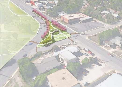
7 Elmendorf Lake Park Project

8 Cantilevered Piers Experience Off Water Picnic Tables Interpretive Signage Picnic Plaza Lighted Overlook Lake


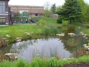
9 Bioswales / Rain Garden Low Frequency Detention First Flush Treatment of Pollutants Wetland Feature Intercepts Water from Street Re-circulates Lake Water Reduces Phosphorous and Nitrogen


10 Lake Access Unique vantage points Wayfinding Signage Interpretive Signage


11 11 Lake Plaza Colorful and Distinctive Seating Recognizable Theme Reflecting Community Culture


12 12 Connectivity 3 Pedestrian Bridges Single Span 200 Single Span 175 Single Span 155 Final Bridge Color Polymer Blue Accent with Graphite Structure

13 Elmendorf Lake Park Project
14
15 15 Status Report Elmendorf Lake Park (Estimated Completion) Jerdon Bridge Project (12/2015) MAC, Inc South Project (01/2016) Journeyman North Project (06/2016) Project Progress Page


16 Status Report Elmendorf Island 16


17 Status Report Elmendorf Island 17


18 Status Report Elmendorf Island 18


19 Status Report Elmendorf Bridge 19


20 Status Report Elmendorf Bridge Final Bridge Color Polymer Blue Accent with Graphite Structure 20


21 Status Report Elmendorf South - 24th Street Looking West Elmendorf South - 24th Street Looking East 21


22 Status Report Elmendorf Lake - Commerce Looking West Elmendorf Lake - Commerce Looking East 22


23 Status Report Elmendorf South - Look East to 24th Street Elmendorf South - Looking west to Commerce Street 23
24 24 Status Report Apache / San Pedro Hike and Bike Trails 10 wide hike and bike linear creekway trails. Apache San Pedro 1.49 miles 2.01 miles Estimated Completion February 2016 Project Progress Page

25 Status Report Apache S. Zarzamora Looking West Apache S. Zarzamora Looking East 25
26 26 Status Report Alazan / Martinez Hike and Bike Trails 10 wide hike and bike linear creekway trails. Alazán Martinez 0.47 miles 0.61 miles Estimated Completion January 2016 Project Progress Pages


27 Status Report Martinez Woodlawn Looking North Martinez Woodlawn Looking South 27


28 Status Report Alazan Waverly Looking South Alazan Waverly Looking North 28
29 Questions? 29

30 WESTSIDE CREEKS SIGNAGE

31 ALAZAN CREEK TRAIL 1. Casting Pond a. West End Lake b. Fish hatchery 2. Neighborhood History a. Basilica of the National Shrine of the Little Flower b. Old Protestant Orphan c. Peacock Academy

32 MARTINEZ CREEK TRAIL 1. Neighborhood Culture a. Deco District b. Oak Farms Dairy c. Miniature Golf 2. Manmade Impacts a. Flood Control b. Expressway c. Roads and Streets

33 APACHE AND SAN PEDRO CREEK TRAIL - SOUTH 1. Produce Market &Cassiano Park 2. Alta Vista Neighborhood

34 APACHE AND SAN PEDRO CREEK TRAIL SOUTH 3. San Fernando Cemetery 4. Alazan Creek Confluence 5. San Pedro Creek Confluence 6. Railroads & Stockyards 7. Expressway

35 APACHE AND SAN PEDRO CREEK TRAIL SOUTH 8. Beanville
36


37 ELMENDORF LAKE PARK 1. History of the Park 2. Culture and Neighborhood of the Westside 3. Life Above the Lake 4. Bioswale Purpose and Function 5. Local Stories & Pastimes 6. Life Below the Lake 7. Invasive Plants


38 ELMENDORF LAKE PARK 8. Swimming, boating and celebrations 9. Apache Creek Water shed 10. Bald Cypress 11. OLLU and the park 12. Water Cycle 13. History of the Island 14. Local Stories and Pastimes 15. Restoring Water Quality 16. Damming and Channeling the Creek
39 THE CASTING POND Mesquite-filled pasture land along the banks of upper Alazan Creek turned into a marsh when the creek overflowed its banks in times of heavy rain. In 1887 real estate speculators bought property along the creek northwest of the congested city and formed the West End Town Company to develop a new neighborhood. The company beautified the isolated subdivision with a lake created by damming the creek. Spring rains soon filled the lake as well as a small pond that formed in the excavation pit just below the dam. Recognizing that rainfall was unpredictable, developers dug artesian wells to assure a constant lake level as well as water for household use. A trolley running across the dam transported city residents out to the lake to boat, picnic, and fish. From 1933 until about 1950, the city operated a fish hatchery in the lower pond. Bass and catfish raised there were used to stock both the lake and the San Antonio River. After the hatchery closed, the picturesque spot became known as the casting pond and remained a popular destination for picnics and fishing. The pond had deteriorated and filled with silt by the late 1900s, but it was restored DATE and remains a popular destination for visitors to Woodlawn Lake.
40
41
42
43
44
45


46 LAKE PLAZA SEATING INTERACTIVE FOUNTAIN LAKE PLAZA ENTRY LAKE PLAZA SEATING ELMENDORF LAKE PARK IMPROVEMENTS TERRA DESIGN GROUP, INC.


47 BEACH ENTRY SWIMMING POOL / PLAYGROUND / ADULT EXERCISE AREA SWIMMING POOL BEACH ENTRY SWIMMING POOL ELMENDORF LAKE PARK IMPROVEMENTS TERRA DESIGN GROUP, INC.


48 INTERPRETIVE SIGNS TRAIL NODE WITH CANTILEVERED PIER T HEAD FISHING PIER PARK MONUMENT SIGN ELMENDORF LAKE PARK IMPROVEMENTS TERRA DESIGN GROUP, INC.


49 COMMERCE STREET FILTERING RAIN GARDEN PARKING LOT FILTERING RAIN GARDEN NORTH PARK WETLAND / BIOSWALE FILTERING RAIN GARDEN AT SHORE DRIVE PARKING ELMENDORF LAKE PARK IMPROVEMENTS TERRA DESIGN GROUP, INC.


50 EA EAST PARK WETLAND ELMENDORF LAKE PARK IMPROVEMENTS TERRA DESIGN GROUP, INC.


51 COMMERCE STREET PEDESTRIAN BRIDGE TRAIL NODE AT 24 TH AND COMMERCE STREET TRAIL UNDER COMMERCE STREET TRAIL WITH SEATING NODES ALONG LAKE SHORE ELMENDORF LAKE PARK IMPROVEMENTS TERRA DESIGN GROUP, INC.
52 52
53 Pedestrian Bridges

54 Stream bank Restoration Hike and Bike Trails
55 Bio-Retention

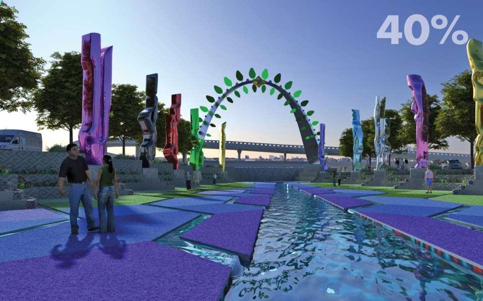
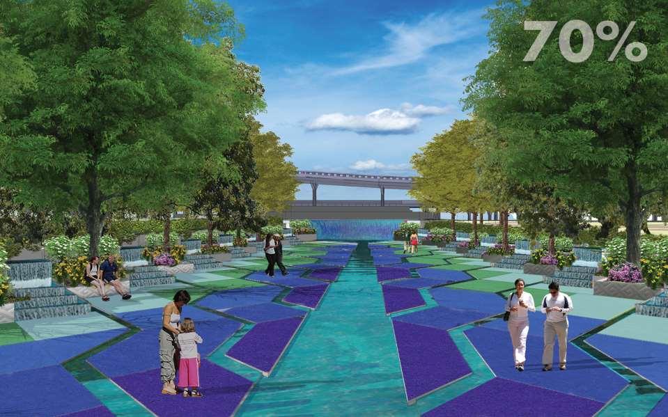
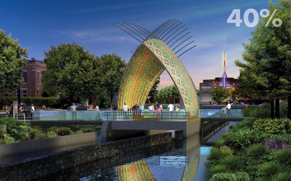
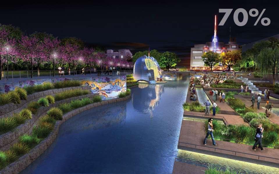
56 Water Fountains


57 Pervious Pavement Pervious Pavement

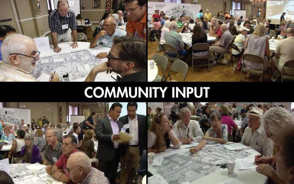
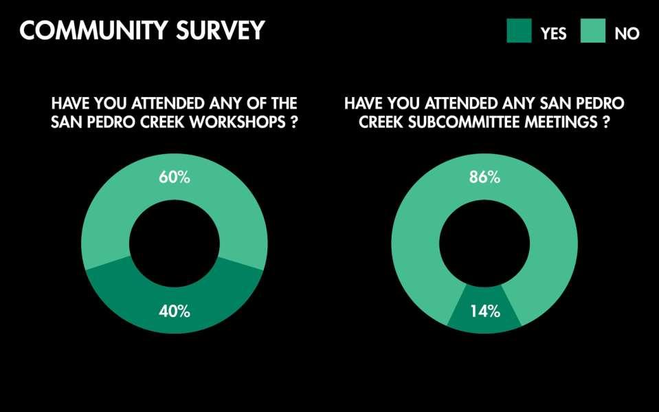
58 Cascading waterfall for Aeration
59 Property Acquisition
60 Constructed Wetlands
61

62 2
63 40% to 70% Design Incorporation of stakeholder input Progression of design details Engineering and architectural design Drawings and specifications HAER field work for historic walls (Historic American Engineering Record; documentation of existing project features) Quality control reviews and coordination for 70% submittal Utility coordination and relocation design Determined final project limits and property to support design Reconciliation of project funding 3
64
65 Public Input & Outreach Three Public Events Four San Pedro Creek Subcommittee Meetings Present updates on design development monthly Public Survey Property Owner Coordination 19 private parcels, 15 owners 1 to 5 meetings with each owner Media Outreach Updates posted regularly on project website: spcproject.org 5
66
67
68
69
70
71 Design Input Response Pathway forward from 70% design: Response to Public, Stakeholder and Property Owner Concerns, Value Engineering, and Cost Reduction Tree of Life Arch and Plaza Salinas bridge shade structure (art curation) Alameda amphitheater and plaza Merodeo curation) Architectural finishes and detailing: integral concrete color, wall finishes and paving pattern selection, architectural railing selection, and pavers at roadways 11
72 Design Input Response, Cont. Pathway forward from 70% design, Cont. Phase 2 as flood control only (full scope completed if funding available) Solidify construction phasing Focus design on Phase 1 & 2 Progress design for phases 3 and 4, behind phases 1 and 2 12
73
74
75
76

77
78
79
80
81
82
83

84
85
86
87 Total Project Costs Preliminary Engineering Report (2013) Total - $175M Conceptual cost estimate High-level study to determine project s feasibility 70% Design Development (2015) Total - $206.8M Market conditions thru 2017 Refined design Better understanding of existing infrastructure Additional structural elements (e.g. walls) Limited property costs Total Project Costs Increase at 18.2% 27
88 40% Design Construction Phasing 28

89 Proposed Construction Phasing 29
90 Going Forward to 90% Design Focus design on Phases 1 & 2 Advance Public Art Development process; adding pedestrian bridges and increasing total art allocation to $3 million Explore design options for modified location of amphitheater Refine design documents to reflect modifications based on public input Phase 2 to proceed with flood control improvements only (no amenities) to meet primary project goal within limited available funding Evaluate design scope based on final direction for phases 1 and 2 Continue design for Phases 3 & 4 once Phase 1 & 2 Bid Documents are complete 30
91 Next Steps August 2015: 70% Design Deliverable Approval November 2015: 90% Design Deliverable Approval February 2016: Final Design May 2016: Start Construction May 2018: Complete significant section for 300 th Anniversary 31
92 Recommendation Recommended Motion: Approval of the 70% intermediate design documents as required by the Cooperative Agreement between Bexar County and the San Antonio River Authority Direct staff and the San Antonio River Authority to finalize design scope and proceed with the completion of 90% design documents for Phase 1 & 2 to be presented to Commissioners Court on current schedule and deliver Phase 3 & 4 at a future date 32

93
2011 ASLA Design Awards. Westside Creeks Restoration Plan Merit Award AECOM, Fort Collins. Planning & Urban Design
 2011 ASLA Design Awards Westside Creeks Restoration Plan Merit Award AECOM, Fort Collins Planning & Urban Design Project Fact Sheet Category of Entry: Rotating Specialty Award: 2011 2011 ASLA Colorado
BURTON STATION STRATEGIC GROWTH AREA PLAN UPDATE PUBLIC MEETING 3/26/18
 BURTON STATION STRATEGIC GROWTH AREA PLAN UPDATE PUBLIC MEETING 3/26/18 1 WHERE WE ARE? 2 PRIMARY OBJECTIVES OF THE PLAN UPDATE 1. Update the land use designation for Burton Station Village to reflect
Grand River Ravines Georgetown Township
 Grand River Ravines Georgetown Township Project Description: The Grand River Ravines County Park property is composed of the 68-acre former Fillmore at the Bend Open Space purchased in 1999 and two more
City of Iowa City Department of Neighborhood and Development Services Department of Parks and Recreation Department of Public Works City Manager s
 RFP Pre-submittal meeting December 18, 2015 City of Iowa City Department of Neighborhood and Development Services Department of Parks and Recreation Department of Public Works City Manager s Office Background
April 11, 2016 Park Board Chair and Commissioners General Manager Vancouver Board of Parks and Recreation New Brighton Salt Marsh - Preferred Concept
 TO: FROM: SUBJECT: April 11, 2016 Park Board Chair and Commissioners General Manager Vancouver Board of Parks and Recreation New Brighton Salt Marsh - Preferred Concept RECOMMENDATION A. THAT the Vancouver
City Council March 27, Parks, Recreation, and Trails Master Plan
 City Council March 27, 2018 Parks, Recreation, and Trails Master Plan Planning Process Develop Goals and Objectives Inventory of Areas and Facilities Needs Assessment And Identification Public Participation
AREA-WIDE PEDESTRIAN AND BICYCLE CIRCULATION
 OUSD LANEY CHILD CARE CENTER ART BUILDING LANEY COLLEGE BALL FIELDS PCCD OFFICES PERALTA PARK AQUATIC CENTER & ESTUARY PARK EDOFF MEMORIAL BANDSTAND SNOW PARK COURT HOUSE OAKLAND MUSEUM OAK ST AREA-WIDE
2035 General Plan Update and Belmont Village Specific Plan. Joint Study Session with the City Council and Planning Commission April 12, 2016
 2035 General Plan Update and Belmont Village Specific Plan Joint Study with the City Council and Planning Commission April 12, 2016 Agenda 1. Welcome and Introductions 2. General Plan Update Status of
Mendota Heights 2040 Comprehensive Plan Draft Vers
 4 Parks and Trails The City of Mendota Heights boasts a variety of recreational and open space opportunities. Few cities can claim access to regional trails, riverside and lakeside parks, scenic bluffs
Howard W. Peak Greenway Trails
 Howard W. Peak Greenway Trails Program Beginnings 1998 - Mayor Howard Peak and other Council members initiated and supported idea of creating linear parks along San Antonio creekways. 1999 - Program plan
Johnson Street Bridge Public Realm Update
 Johnson Street Bridge Public Realm Update August 20, 2015 Background Johnson Street Bridge Replacement Project impacts a diverse range of stakeholders In addition to a new bridge, the project also includes
Chapter Purpose and Intent. 7.2 Applicability. 7.3 General Provisions RECREATIONAL OPEN SPACE
 Chapter 7. RECREATIONAL OPEN SPACE 7.1 Purpose and Intent The intent of this Chapter is to provide for centrally located, unencumbered land as neighborhood recreational open space and not to permit the
The following principles guide the development of goals and strategies to protect and promote these amenities:
 OPEN SPACE/PARKS/TRAILS/RECREATION GOALS/STRATEGIES Cherry Hills Village is a living environment that offers low density development, open areas, public scenic vistas, public trails and public parks. This
A larger version of this map is located on the last page of this PDF.
 MAP Committee Input McLoughlin Area Draft Vision Map A larger version of this map is located on the last page of this PDF. 1. The map above is intended to portray a vision for the McLoughlin area. It highlights
Maplewood Avenue Downtown Complete Street Project
 Maplewood Avenue Downtown Complete Street Project Second Public Meeting January 24, 2018 Welcome and Introduction of Project Team City Planning and Public Works Staff City of Portsmouth Juliet Walker Planning
ARROYO PROJECTS ADOPTED CAPITAL IMPROVEMENT PROGRAM BUDGET
 A RROYO P ROJECTS ADOPTED CAPITAL IMPROVEMENT PROGRAM BUDGET FISCAL YEARS 214-218 HAHAMONGNA Priority Description 1 Hahamongna Watershed Park - Implement Master Plan 211,6 211,6 (77565) 2 Hahamongna -
Preliminary Sketch Plan for Fort Hunter Park
 Preliminary Sketch Plan for Fort Hunter Park Public Presentation November 19, 2009 Dauphin County Parks and Recreation 100 Fort Hunter Road Harrisburg, PA 17110 (717) 599-5188 www.dauphinc.org THOMAS COMITTA
ADOPTED CAPITAL IMPROVEMENT PROGRAM BUDGET ARROYO PROJECTS
 ADOPTED CAPITAL IMPROVEMENT PROGRAM BUDGET ARROYO PROJECTS HAHAMONGNA FY 212-216 Capital Improvement Program Priority Description Total Estimated Costs Appropriated Through FY 211 Adopted FY 212 FY 213
WESTERN ILLINOIS UNIVERSITY
 WESTERN ILLINOIS UNIVERSITY Quad Cities Riverfront Campus Preliminary Master Plan Presentation 2 February 1, 2006 Achieving Future Flexibility 1. Monitor space needs as the new buildings come on line and
Fair Oaks Ranch Homeowners Association Parks and Trails Master Plan & 2019 Budget Planning
 Fair Oaks Ranch Homeowners Association Parks and Trails Master Plan & 2019 Budget Planning Sticky Dot Voting Priorities Community Survey Results Board Title Votes Parks, Open Spaces, and Trails 328 Emergency
M E M O R A N D U M. DATE: July 19, Patrick D. O Keeffe, City Manager. Economic Development & Housing
 M E M O R A N D U M DATE: July 19, 2011 TO: FROM: Patrick D. O Keeffe, City Manager Economic Development & Housing SUBJECT: Resolution of the City Council of the City of Emeryville Approving the Application
Town of Lyons Parks Flood Recovery Planning Process. Photograph courtesy of Ed Bruder
 Town of Lyons Parks Flood Recovery Planning Process Photograph courtesy of Ed Bruder Lyons Parks and Recreation Flood Recovery Update 1. Meadow Park Phase II - Project PW20B1 Estimated Completion: Summer
Las Colonias Park Master Plan
 2013 Las Colonias Park Master Plan City of Grand Junction June 2013 Introduction Las Colonias Park, a 101 acre parcel on the edge of the Colorado River south of downtown, was deeded to the City of Grand
TOWN COUNCIL / PLANNING COMMISSION
 Workshop #3 TOWN COUNCIL / PLANNING COMMISSION January 20, 2011 Consultant Team In Attendance Tonight BMS Design Group Nevada City and San Francisco Michael Smiley, AICP, ASLA Partner-in-Charge Nancy L.
VIRGINIA KEY CONSENSUS MASTER PLAN
 VIRGINIA KEY CONSENSUS MASTER PLAN JULY 2010 Existing Conditions JULY 2010 STAKEHOLDER INTERVIEW PROCESS, January 18-22, 2007 PUBLIC MEETING #1: SITE INVENTORY AND ANALYSIS, March 29, 2007 PUBLIC MEETING
Project Location. Jay and Patty Baker Park and Gordon River Greenway Connector Bridge. Naples Beach Golf Club. Gordon River. East. Naples.
 Gordon River Project Location Naples Beach Golf Club East Naples Naples Naples Bay Evergreen Golf and Country Club and Gordon River Greenway Connector Bridge Gordon River Greenway CONNECTOR BRIDGE AND
Emerson Park Master Plan Update. Public Meeting III August 27, 2014
 Emerson Park Master Plan Update Public Meeting III August 27, 2014 Meeting Agenda: Project Update Presentation of Master Plan Components Discussion and Feedback The Path Forward: Building on the Concept
MCCOYS CREEK RESTORATION 30% DESIGN
 MCCOYS CREEK RESTORATION 30% DESIGN THE MCCOYS CREEK RESTORATION PLAN The restoration plan aims to reduce flooding, restore ecosystem health, expand recreational opportunities along the creek, and connect
Waterfront Development Master Plan
 PORT of VANCOUVER USA Vancouver, WA Waterfront Development Master Plan DRAFT - FINAL CONCEPTUAL MASTER PLAN PROJECT TEAM NBBJ Heritage Research Associates JLA Kittelson Associates Leland Consulting Group
EASTSIDE REGIONAL PARK MASTER PLAN
 EASTSIDE REGIONAL PARK MASTER PLAN Goal 3: Promote the visual image of El Paso Goal 4: Enhance El Paso s Quality of Life through Recreational, Cultural and Educational Environments Goal 4.1: Deliver bond
SECTION 4(f) DE MINIMIS DOCUMENTATION
 DE MINIMIS DOCUMENTATION") SECTION 4(f) DE MINIMIS DOCUMENTATION Illinois Route 60/83 IL 176 to the intersection of IL 60 (Townline Road) Lake County P-91-084-07 Mundelein Park and Recreation District Project Limit SECTION 4(f)
SECTION 4(f) DE MINIMIS DOCUMENTATION Illinois Route 60/83 IL 176 to the intersection of IL 60 (Townline Road) Lake County P-91-084-07 Mundelein Park and Recreation District Project Limit SECTION 4(f)
The Benefits and Challenges Associated with Green Infrastructure Practices
 The Benefits and Challenges Associated with Green Infrastructure Practices Thomas M. Evans ASLA, LEED AP Regional Green Infrastructure Design Services Director OWEA Technical Conference, June 20, 2013
Long Branch-Wayne Local Park Renovation Project
 Montgomery Parks Long Branch-Wayne Local Park Renovation Project Community Meeting #2 September 20, 2016 Oak View Elementary School 7:00-9:00 PM Welcome / Team Introductions M-NCPPC (Montgomery Parks)
Green Infrastructure and Low-Impact Development Technologies
 Green Infrastructure and Low-Impact Development Technologies The guiding principles of these technologies is to manage stormwater at their sources using natural means, and establish conditions so that
Illustration of Eastlake Farmer s Cooperative Grain Elevator. Chapter 5: implementation 5-1
 Illustration of Eastlake Farmer s Cooperative Grain Elevator Chapter 5: implementation 5-1 chapter 5: implementation Introduction The Eastlake Subarea Plan includes a wide range of recommendations intended
AVONDALE ESTATES GREENSPACE AD-HOC COMMITTEE
 AVONDALE ESTATES GREENSPACE AD-HOC COMMITTEE INVENTORY AND RECOMMENDATIONS REPORT November 7, 2018 Our Mission Statement: To provide assistance and support, through professional expertise in matters of
WARM SPRINGS PARK MASTER PLAN
 TABLE OF CONTENTS page 1.0 Introduction and Overview 1 2.0 Information Gathering 2 3.0 Conceptual Alternative Development 8 4.0 Master Plan Development 14 5.0 Construction Cost Estimates 19 LIST OF FIGURES
The Auburn Plan Designing the Future of Auburn February 28, 2005
 The Auburn Plan Designing the Future of Auburn February 28, 2005 Block-by-Block Bicycle Tour Aerial survey Focus Group Meetings September 7 and 8 Design Workshops October 11, 14, and 21 Revitalization
Minto-Brown Island. November 18, City of Salem, Parks & Transportation Services
 Minto-Brown Island Park Master Plan Public Meeting #1 November 18, 2014 City of Salem, Parks & Transportation Services Division, i i Public Works Welcome... and thanks for participating in the master planning
Gold Line Bus Rapid Transit Transit Oriented Development (BRTOD) Helmo Station Area Plan
 Helmo Station Area Plan") Appendix F Gold Line Bus Rapid Transit Transit Oriented Development (BRTOD) Helmo Station Area Plan Introduction and Purpose of the Plan The Gold Line Bus Rapid Transit facility is an eleven-mile dedicated
Appendix F Gold Line Bus Rapid Transit Transit Oriented Development (BRTOD) Helmo Station Area Plan Introduction and Purpose of the Plan The Gold Line Bus Rapid Transit facility is an eleven-mile dedicated
Southeast Quadrant Plan
 Southeast Quadrant Plan Southeast Quadrant Distinctive Features Land Use The Southeast Quadrant includes all the area within the planning area that is east of Interstate 5 and south of State Route 44.
WELCOME! 8 8:30 6: TH STREET IMPROVEMENTS. Open House. Presentation & Q&A
 WELCOME! 168 TH STREET IMPROVEMENTS 6:30 Open House 7 8 Presentation & Q&A 8 8:30 Open House WELCOME Todd Pfitzer City of Omaha Engineer Bob Stubbe City of Omaha Public Works Director Jon Meyer Project
Urban runoff in my neighborhood (Capitol Hill) is heavy with trash and other debris.
 is heavy with trash and other debris.") South Platte River Meeting Comments & s #1 I am a huge fan of river areas and would love the Platte and surrounding waterways to improve to allow habitat for wildlife and recreation opportunities for citizens.
South Platte River Meeting Comments & s #1 I am a huge fan of river areas and would love the Platte and surrounding waterways to improve to allow habitat for wildlife and recreation opportunities for citizens.
Charles P. Johnson and Associates. Annapolis Landscape Architects
 Charles P. Johnson and Associates Annapolis Landscape Architects AGENDA Introduction Project Limits and Scope Site Analysis Opportunities & Constraints Program Goals Image Boards Design Alternatives Pros
10.0 Open Space and Public Realm
 10.0 Open Space and Public Realm 10.0 Open Space and Public Realm The Public Open Space System is comprised of: outdoor spaces available for public use that are either publicly owned (e.g., parks and
New Partners for Smart Growth Conference February 5, 2010
 Dan Stroh, Planning Director City of Bellevue Planning and Community Development Bellevue, WA New Partners for Smart Growth Conference February 5, 2010 Summary of Project Long-range plan update for Bel-Red
MASTER PLAN for the EARL NEWHOUSE WATERFRONT
 MASTER PLAN for the EARL NEWHOUSE WATERFRONT on RESERVOIR POND - CANTON, MA Community Meeting #2 - Thursday, January 11 th PROJECT INTRODUCTION Project Goals: To prepare a MASTER PLAN which develops the
PROJECT INFORMATION UNBUILT PUBLIC LIBRARY LATE 2017 TYPE II-B CONCRETE MASONRY WEATHERING STEEL GLASS GABION WALLS $6.4 MILLION 13,000 SF
 PROJECT INFORMATION PROJECT CATEGORY TYPE OF PROJECT COMPLETION DATE TYPE OF CONSTRUCTION MATERIALS USED COST BUILDING AREA UNBUILT PUBLIC LIBRARY LATE 2017 TYPE II-B CONCRETE MASONRY WEATHERING STEEL
RECREATION, OPEN SPACE AND GREENWAYS ELEMENT GOALS, OBJECTIVES, AND POLICIES
 RECREATION, OPEN SPACE AND GREENWAYS ELEMENT GOALS, OBJECTIVES, AND POLICIES GOAL R-1: DEVELOP A RECREATION, OPEN SPACE AND GREENWAYS SYSTEM AS AN INTEGRAL COMPONENT OF AN OVERALL, COUNTY-WIDE ECONOMIC
Green Infrastructure Recommendations For Parks and Public Spaces
 Green Infrastructure Recommendations For Parks and Public Spaces Issued by the Jersey Water Works Green Infrastructure Committee And Prepared by Meliora Design This document recommends ways to integrate
Jill Stachura STORMWATER BMP AND STREAM RESTORATION IN A CITY PARK. October 2013 Southeast Stormwater Association Annual Conference, Charlotte, NC
 Jill Stachura STORMWATER BMP AND STREAM RESTORATION IN A CITY PARK October 2013 Southeast Stormwater Association Annual Conference, Charlotte, NC Project Location Gwinnett County, GA: Population: 825,000
Yahoo! Inc. CO-7. Santa Clara Valley Urban Runoff. Site Location: 701 First Avenue Sunnyvale, CA
 Yahoo! Inc. CO-7 Site Location: 701 First Avenue Sunnyvale, CA Rocky swales Multi-story buildings reduce building footprint Access to the Bay Trail open space area including parking available for visitors
An Ambitious Plan: Transforming the blighted South Platte River and surrounding environment into Denver s greatest natural resource.
 CONNECTING THE PEOPLE TO THEIR RIVER SOUTH PLATTE RIVER VISION IMPLEMENTATION PROGRAM: GRANT-FRONTIER PARK TO OVERLAND POND PARK REACH The South Platte River Vision Implementation Program (River Vision)
Oroville Area Urban Greening Plan. Joint Meeting of the Oroville Planning, Park, and Arts Commissions October 12, 2015
 Oroville Area Urban Greening Plan Joint Meeting of the Oroville Planning, Park, and Arts Commissions October 12, 2015 Project Team Lead Agency Butte County Department of Development Services Claudia Stuart,
Whitemarsh Comprehensive Plan Update: Housing & Land Use. Public Workshop #3: September 20, 2018
 Whitemarsh Comprehensive Plan Update: Housing & Land Use Public Workshop #3: September 20, 2018 Agenda Welcome Process Recap What We ve Heard The Plan Framework Review of Recommended Actions Land Use Housing
Green Gables. April 24, 2013
 Green Gables Preliminary and Final Plat April 24, 2013 Development Team Green Gables Development Corporation (Owner/Developer) DTJ Design (Planner/Landscape Architect) Enertia Consulting Group (Civil Engineer)
RECREATION AND OPEN SPACE VISION
 City of South Lake Tahoe General Plan Policy Document Recreation and Open Space Element INTRODUCTION This element provides the policy context for the City of South Lake Tahoe to achieve its vision for
Lilburn, GA STORMWATER BMP AND STREAM RESTORATION IN A CITY PARK. July 2013 Jill Stachura
 Lilburn, GA STORMWATER BMP AND STREAM RESTORATION IN A CITY PARK July 2013 Jill Stachura Project Location Gwinnett County, GA: Population: 825,000 Area: 437 sq. miles 1,300 miles storm drainage system
Reconnecting to a Forgotten River St. Cloud MN. Aaron Hanson Design Design Thesis LA 572, Thesis, Spring 2012
 Reconnecting to a Forgotten River St. Cloud MN Aaron Hanson Design Design Thesis LA 572, Thesis, Spring 2012 site context 2.5 Miles Sartell St. Cloud to Fargo 170 Miles (2 hrs 45 mins) Hwy 10 infrastructure
Submitted by: Phillip L. Harrington, Director, Department of Public Works. Framework for Green Infrastructure Plan Development
 Page 1 of 8 Office of the City Manager CONSENT CALENDAR June 13, 2017 To: From: Honorable Mayor and Members of the City Council Dee Williams-Ridley, City Manager Submitted by: Phillip L. Harrington, Director,
Project purpose. advise. The purpose of the Beaumaris Lake Open Space Rehabilitation project is to: + Develop a Functional Program Concept
 Project purpose owns Road Beaumaris Road The purpose of the Beaumaris Lake Open Space Rehabilitation project is to: + Develop a Functional Program Concept + Guide Rehabilitation of Landscape and Community
LOUISIANA STATE UNIVERSITY COMPREHENSIVE & STRATEGIC CAMPUS MASTER PLAN. APPENDIX G - Stormwater Study Findings & Stormwater Solutions
 LOUISIANA STATE UNIVERSITY COMPREHENSIVE & STRATEGIC CAMPUS MASTER PLAN APPENDIX G - Stormwater Study Findings & Stormwater Solutions LSU: MP Narrative July 2017 3.5 Open Space Existing Conditions The
Town Centre Park. Delahaye. David Avenue. Pine wood. Pipeline Rd. Pinetree. Town Ctr Blvd. Guildford. Guildford. High St. Westwood. Pinetree.
 WELCOME This open house is to give you an opportunity to review the proposed design of an outdoor performance and events plaza at Town Centre ark and to share your ideas, suggestions and thoughts related
Tale of Two Cities: Exploring How Two Communities are Using Green Infrastructure to Reduce Flood Risk
 Tale of Two Cities: Exploring How Two Communities are Using Green Infrastructure to Reduce Flood Risk NACo Steering Subcommittees Education Session Lori Cary-Kothera NOAA Coastal Services Center Issue
Potential Green Infrastructure Strategies May 6, 2015 Workshop
 Potential Green Infrastructure Strategies May 6, 2015 Workshop Background The City of Cortland is developing the Tioughnioga Urban Headwaters Green Infrastructure Action Plan with funding from the National
BeltLine Corridor Environmental Study
 BeltLine Corridor Environmental Study Joint TAC and SAC Meeting December 8, 2008 What We Will Discuss Today Outreach and Agency Coordination Scoping Results Existing Conditions Historical and Archeological
CHAPTER 7: Transportation, Mobility and Circulation
 AGLE AREA COMMUNITY Plan CHAPTER 7 CHAPTER 7: Transportation, Mobility and Circulation Transportation, Mobility and Circulation The purpose of the Transportation, Mobility and Circulation Chapter is to
Dowdy Park. Concept Plans TOWN OF NAGS HEAD NORTH CAROLINA. Developed by: Albemarle & Associates, Ltd VHB/ Vanasse Hangen Brustlin, Inc.
 TOWN OF NAGS HEAD NORTH CAROLINA Concept Plans Developed by: Albemarle & Associates, Ltd VHB/ Vanasse Hangen Brustlin, Inc. Site Looking Southeast Dowdy Park Existing Conditions Nags Head Woods Sound Future
Public Information Meeting
 Today s Agenda: Open House - (5:30-7PM) Presentation- (5:45PM) County Project: P-5351-1 FDOT Project :242172-1-58-01 Public Information Meeting Technical Design Team Volusia County Jim White, P.E.- Project
Fall 2017 Construction Update
 Fall 2017 Construction Update Ward 4 Southeast Engineering Department Riverwalk Red Multi-Use Trail Bridge Rehabilitation The Riverwalk Red Multi Use Trail Bridge was awarded to Cramer and Associates,
Lowe Park Master Plan Update Marion, IA August 25 th, 2011
 Lowe Park Master Plan Update Marion, IA August 25 th, 2011 Lowe Park Master Plan Update Concept Plan - June 1 st, 2011 Agenda 1 - INTRODUCTION Vision Statement Aerial of Existing Condition 2 MASTER PLAN
Urban Water Management (ESRM 311 & SEFS 507) Cougar Mtn Regional Wildland Park & Lakemont Blvd, Bellevue WA
 Cougar Mtn Regional Wildland Park & Lakemont Blvd, Bellevue WA") Urban Water Management (ESRM 311 & SEFS 507) Cougar Mtn Regional Wildland Park & Lakemont Blvd, Bellevue WA Lecture Today Urban Water management terms Examples of water management in urban areas Field
Urban Water Management (ESRM 311 & SEFS 507) Cougar Mtn Regional Wildland Park & Lakemont Blvd, Bellevue WA Lecture Today Urban Water management terms Examples of water management in urban areas Field
W&OD PARK MASTER PLAN. The City s Greenest Street. DRAFT W&OD Trail Master Plan v4.docx Page 1
 W&OD PARK MASTER PLAN Adopted XXX-XX-XXXX The City s Greenest Street DRAFT W&OD Trail Master Plan v4.docx Page 1 Introduction and Purpose The Washington & Old Dominion Railroad Regional Park (W&OD) (which
KASPER. City of Georgetown, Texas PUD Planned Unit Development. December 30, 2015 Revised January 27, 2016
 KASPER City of Georgetown, Texas PUD Planned Unit Development December 30, 2015 Revised January 27, 2016 Applicant: Sentinel Land Company, LLC 4910 Campus Drive Newport Beach, CA Prepared by: SEC Planning
FY Capital Improvement Program Arroyo Projects
 FY 219-223 Capital Improvement Program FY 218 FY 219 FY 22 FY 221 FY 222 FY 223 1 2 3 4 5 6 7 8 9 1 Hahamongna - Implement Master Plan - Oak Grove Area Improvements (7756) Hahamongna - Implement Master
Silver Creek Subdivision Public Park
 Silver Creek Subdivision Public Park Design Team: team80026 Munding Design Lead Consultant Gaia Designs Landscape Architect Wildrye Design Landscape Architect Akamai Design Civil Engineer introduction
VEHICULAR AND PEDESTRIAN CIRCULATION
 This perspective sketch communicates the intended character and quality of a proposed streetscape design. Locate benches near a major intersection where people tend to gather. Seating and lighting provide
SOUTH FOX MEADOW STORMWATER IMPROVEMENT PROJECT
 VILLAGE OF SCARSDALE WESTCHESTER COUNTY, NEW YORK COMPREHENSIVE STORM WATER MANAGEMENT SOUTH FOX MEADOW STORMWATER IMPROVEMENT PROJECT In association with WESTCHESTER COUNTY FLOOD MITIGATION PROGRAM Rob
STUDY AREA. Tonight s Agenda. Project Tasks Completed. Next Steps. Town of Oyster Bay Eastern Waterfront Community Vision & Revitalization Plan
 Town of Oyster Bay Eastern Waterfront Community Vision & Revitalization Plan Public Meeting January 27, 2009 Opening Remarks Presentation Tonight s Agenda Introduction Study Area Overview Public Participation
Welcome! to Keller Town Hall
 Welcome! to Keller Town Hall Keller Town Center Planning a New Downtown What is Keller Town Center? A new, growing downtown district planned as an urban village A combination of retail and office spaces,
WESTERN ILLINOIS UNIVERSITY
 WESTERN ILLINOIS UNIVERSITY Quad Cities Riverfront Campus Master Plan March 1, 2006 Preliminary Master Plan Total Site Build Out Western Illinois University Quad Cities Municipal Park Mississippi River
SOUTHEAST SPORTS COMPLEX MASTER PLAN
 REPORT TO SOUTHGATE NEIGHBORHOOD COUNCIL APRIL 13, 2016 Visioning Process April 30: Stakeholder Meeting with Sports Groups May 5: Stakeholder Meeting with Southgate Land Use Committee May 13: SNC Meeting
Redevelopment Plan for the Former South Gifford Road Landfill
 Redevelopment Plan for the Former South Gifford Road Landfill Summary Report July 2018 Treasure Coast Regional Planing Council Former South Gifford Road Landfill Site Redevelopment Plan July 2018 prepared
BRADENTON RIVERWALK EXPANSION MASTER PLAN
 BRADENTON RIVERWALK EXPANSION MASTER PLAN INTRODUCTION & AGENDA Process Update Community Engagement Summary Center for Active Design (CfAD) Recommendations Context and Existing Conditions Master Plan Alternatives
Northeast Quadrant Plan
 Northeast Quadrant Plan Northeast Quadrant Distinctive Features Land Use The Northeast Quadrant includes all the area within the planning area that is east of Interstate 5 and to the north of State Route
Provide and maintain sufficient public parks, recreation facilities, and open space to meet the recreational needs of County residents and visitors.
 (ROS) Goal Provide and maintain sufficient public parks, recreation facilities, and open space to meet the recreational needs of County residents and visitors. OBJECTIVE ROS.01 The County shall acquire,
Great Rivers Greenway CLEAN GREEN CONNEC TED T RAILS
 Great Rivers CLEAN GREEN CONNEC TED T RAILS Great Rivers (GRG) was established in 2000 to create a clean, green, connected St. Louis region. Today, many new and exciting projects demonstrate the social,
SOUTH UNIVERSITY Street Design Alternatives in Progress
 1 Alternatives in Progress 2016.01.20 Meeting Agenda 2 1. Progress & Schedule 2. Utilizing the Street Design Manual 3. Site Characteristics and Input Received 4. Street Geometry What can we accomplish
San Francisco Bay Pilot: Sausal Creek Community Leader Charrette May 11, 2016 Marcus Griswold
 San Francisco Bay Pilot: Sausal Creek Community Leader Charrette May 11, 2016 Marcus Griswold 1 Overview Project Overview Watershed Context Assets and Challenges Opportunities Green Streets Creek Access
Philip A. Ginsburg, General Manager Toks Ajike, Acting Planning and Capital Program Director
 Date: March 7, 2018 To: Through: From: Subject: Recreation and Park Commission Capital Committee Philip A. Ginsburg, General Manager Toks Ajike, Acting Planning and Capital Program Director Dan Mauer,
continues in the watershed, additional flood control and water quality / natural system improvements may be required in the future.
 The Duck Pond Watershed is located in northern Hillsborough County in an area in which a number of land and water management issues are currently being addressed by citizen's action groups and state, regional
Lake and Stream Restoration Project
 Pre-project Fact Sheet May 2012 Toledo Botanical Garden (TBG) is a 60 acre public garden visited by more than 120,000 people annually. It is located in Toledo, Ohio in the Ottawa River watershed within
New Brighton Park Shoreline Habitat Restoration Project
 Vancouver Board of Parks and Recreation and Port Metro Vancouver New Brighton Park Shoreline Habitat Restoration Project Conceptual Design Public Consultation August 26 September 9, 2015 Discussion Paper
PARTF Scoring System for Grants
 PARTF Scoring System for Grants The members of the N.C. Parks and Recreation Authority use the PARTF scoring system as one of several tools to select grant recipients. Please provide all of the information
Urban Water Management and Soils (ESRM 311 & SEFS 507)
") Urban Water Management and Soils (ESRM 311 & SEFS 507) Cougar Mtn Regional Wildland Park & Lakemont Blvd, Bellevue WA Lecture Today Some Urban Water management terms Examples of water management in urban
Urban Water Management and Soils (ESRM 311 & SEFS 507) Cougar Mtn Regional Wildland Park & Lakemont Blvd, Bellevue WA Lecture Today Some Urban Water management terms Examples of water management in urban
A Vision for Walnut Creek
 A Vision for Walnut Creek Photo: City of Clive Walnut Creek Booklet 8 of 8 Greater Des Moines Water Trails and Greenways 1 Table of Contents Booklet 1: Water Trails Strategies and Policies Booklet 2: Beaver
CY-FAIR ISD Exemplary-rated schools
 -ACRE master planned community GREEN SPACE within a quarter-mile of every home -SQ.FT. community center CY-FAIR ISD Exemplary-rated schools Located in Cypress, Texas, Bridgeland is northwest Houston s
Please read the entire document
 projects impacting the waterfront revitalization area. The waterfront revitalization area of the town will have to subareas to the west and east of the village. Page 6 of 6 Wayfinding master plan create
RECREATION AND OPEN SPACE ELEMENT GOALS, OBJECTIVES, AND POLICIES
 RECREATION AND OPEN SPACE ELEMENT GOALS, OBJECTIVES, AND POLICIES Goal 7 To provide park facilities, recreation programs, and open space resources that are safe, adequate, and accessible to all City residents,
Errol Heights Park and Community Garden Frequently Asked Questions March 22, 2018
 Errol Heights Park and Community Garden Frequently Asked Questions March 22, 2018 Question 1: What improvements are planned for Errol Heights Park? How will the community be engaged in the process to shape