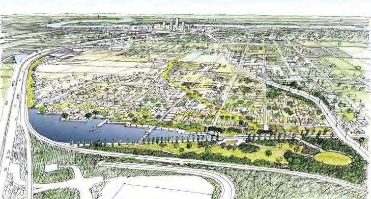
NEW ORLEANS LAKEVIEW FLOATING STREETS
|
|
|
- Arthur Harvey
- 6 years ago
- Views:
Transcription


1 INTERCEPTOR STREETS INTERCEPTOR STREETS: EXISTING UPTOWN TO BUCKTOWN COORDINATING INVESTMENTS LAKEVIEW FLOATING STREETS Katrina Memorial Lake Avenue mixed-use waterfront Networks of bike and pedestrian West End storage basin and park Slow, Store, Drain vacant lots Emergency water reduce subsidence Canal Street Canal Redesign canal to store water in rain event; in dry periods 17th Street Canal Upper lower water level; widen canal; lower walls; bike and pedestrian access Lower capacity 17th Street Canal Lower Cascade to slow stormwater and storage capacity and riverfront development adjacent to new development Emergency inlet to reduce subsidence for river water Bike Trail New inlet for drinking water outlet for Claiborne Emergency stormwater Drain Hollygrove NORA lots and parks Split of water basins Xavier University waterfront development Raise water levels; provide pedestrian


2 LAKEVIEW FLOATING STREETS MONTICELLO CANAL West End 3 outlet street 3 To pump 12 2 normal street 1 normal street Fleur de Lis 2 3 A) Subsurface ow 1 To Pump Sta on # 12 Schema c situa on B) Surface of ow project area MONTICELLO CANAL MONTICELLO ENGINEERED PROPOSAL


3 HOEY S BASIN / MONTICELLO CANAL HOEY S BASIN / MONTICELLO CANAL image: Bosch Slabbers, Waggonner & Ball HOEY S BASIN / MONTICELLO CANAL HOLLYGROVE/MONTICELLO CANAL image: Bosch Slabbers, Waggonner & Ball

 3.0 2.")

 Orleans Canal -8")
4 LAKEVIEW AND BUCKTOWN LONDON AVENUE CANAL LONDON AVENUE CANAL OUTFALL CANALS Eleva on ( NAV VD) Eleva on ( NAV VD) Distance from DPS7 ( ) Orleans Canal Distance from DPS03 ( ) London Avenue Canal


5 OUTFALL CANAL PROPOSED STORMWATER FLOWS System scale water storage Small scale strategies to slow water Split at the ridge waterworks 5 miles S PROPOSED DRY SYSTEM FLOWS DUTCH DIALOGUES III CIRCULATING SYSTEMS Brackish water Fresh water Urban wetland filtration 5 miles


6 DUTCH DIALOGUES CIRCULATING SYSTEM LAFITTE BLUEWAY - DRAINAGE IMPACT image: Pieter Schengenga & Lodewijk van Nieuwenhuijze LAFITTE GREENWAY SUSTAINABLE WATER DESIGN HISTORIC CONNECTIONS LAFITTE CORRIDOR


7 BRIDGEPORT RAIN GARDEN LAFITTE BLUEWAY image: Bosch Slabbers LAFITTE GREATER GREENWAY SUSTAINABLE URBAN WATER PLAN DESIGN LAFITTE BLUEWAY - WET LAFITTE GREENWAY SUSTAINABLE WATER DESIGN HISTORIC IDENTITY image: Bosch Slabbers


8 HISTORIC WATERWAYS ROTTERDAM OLD HARBOR LAFITTE BLUEWAY FROM BASIN REGIONAL PLAN NDRC DELTA ADAPTATION Lake Borgne Gulf of Mexico New Orleans East St. Bernard New Orleans Jefferson Parish Lake Pontchartrain West Bank PAST CURRENT FUTURE image: Palmbout Urban Landscapes


9 Living Shoreline NDRC PROJECTS NDRC: OUTFALL CANALS PERM. PUMP STATION/CLOSURE STRUCTURE Orleans Ave Canal City Park Microgrids TEMP. PUMP STATION/CLOSURE STRUCTURE Blue-Green Corridors St. Anthony Green Streets LMI Homeowner Resilience Retrofit Program PROPOSED PUMP STATION 600 CFS Milne Campus Pontilly Neighborhood Green Infrastructure London Ave Canal Art/Intervention Mirabeau Water Garden Dillard Wetland St. Bernard Neighborhood Campus Water Monitoring Network PROPOSED +8 USACE PROPOSED SAFE WATER LEVEL AFTER PENDING BUTTRESSING +5 CURRENT SAFE WATER LEVEL -1 ~+1 TYP. TIDAL FLUCTUATION EXISTING GROUND GABION 2 MIN FREEBOARD SIDEWALK 10'-0" COMPACTED FILL TO ELEVATE LEVEE TO +10 MIN SECTION AREA 77sf EXISTING TOE OF LEVEE NEW TOE OF LEVEE Bayou St. John Neighborhood Green Infrastructure St. Roch Green Streets CONCRETE REVETMENT EXISTING SHEET PILE DEEP AVG. PROPOSED TO REMAIN REMOVE WALL (KEEP THE SHEET PILE) ADD GABIONS AND CONCRETE REVETMENT TO STABILIZE THE BANK ADD EXTRA FILL TO COVER THE SHEET PILE AND ELEVATE LEVEE TO MAINTAIN SAFE FREEBOARD PLACE A NEW SIDEWALK WHERE THE ORIGINAL WALL WAS MAINTAIN EXISTING WATER LEVELS SEA LEVEL EXISTING PUMP STATION 2,900 CFS CITY PARK NDRC CITY PARK RUNOFF INTO CITY PARK FROM LAKE VISTA NEIGHBORHOOD SIPHON UNDER ORLEANS CANAL CONSTRUCTED WETLANDS FILTER AND INFILTRATE POTENTIAL OVERTOPPING FROM ORLEANS CANAL 1 foot of storage: Acre Feet 2 feet of storage: 263 Acre Feet 3 feet of storage: 540 Acre Feet 4 feet of storage: 982 Acre Feet NEW CONNECTIONS BETWEEN LAKES LAKE BED DREDGED TO INCREASE FLOW AND STORAGE CAPACITY NEW GOLF COURSE REDIRECTED FLOW INTO CITY PARK ORLEANS CANAL COUTURIE FOREST LAKEVIEW SIPHON UNDER ORLEANS CANAL LAKE VISTA NEW OPERABLE WEIR SCOUT ISLAND FILTRATION WETLAND -4.5 BELOW SEA LEVEL TYPICAL WATER LEVEL ALTERNATE WEIR LOCATION NEW OPERABLE WEIRS NEW WATER CONNECTION
Lafitte Greenway Sustainable Water Design
 Lafitte Greenway Sustainable Water Design New Orleans, Louisiana Initiated by the Friends of the Lafitte Corridor and made possible by a Greater New Orleans Foundation Environmental Fund grant, Waggonner
LIVING WITH WATER. Waggonner & Ball. David Waggonner OREGON ASSOCIATION OF CLEAN WATER AGENCIES JULY 27, 2016 LOUISIANA COASTAL CONDITION
 David Waggonner Waggonner & Ball LOUISIANA COASTAL CONDITION LIVING WITH WATER OREGON ASSOCIATION OF CLEAN WATER AGENCIES JULY 27, 2016 LOUISIANA HIGH + LOW LANDSCAPE LOUISIANA WETLAND LOSS image: Monique
An Integrated Approach for Water Management Examples from The Netherlands. Addressing Climate Change and Sea Level Rise
 An Integrated Approach for Water Management Examples from The Netherlands Addressing Climate Change and Sea Level Rise Superstorm Sandy Forum College of Staten Island March 8 2013 Water: a challenge and
LOUISIANA STATE UNIVERSITY COMPREHENSIVE & STRATEGIC CAMPUS MASTER PLAN. APPENDIX G - Stormwater Study Findings & Stormwater Solutions
 LOUISIANA STATE UNIVERSITY COMPREHENSIVE & STRATEGIC CAMPUS MASTER PLAN APPENDIX G - Stormwater Study Findings & Stormwater Solutions LSU: MP Narrative July 2017 3.5 Open Space Existing Conditions The
Lessons Learned from Katrina and Reducing Vulnerability Fall 2011
 Page 1 of 9 TIDE-1220 Tulane University New Orleans & Hurricanes Prof. Stephen A. Nelson Lessons Learned from Katrina and Reducing Vulnerability Fall 2011 This document last updated on 21-Sep-2011. Why
Stormwater Management at The University of New Orleans
 University of New Orleans ScholarWorks@UNO DRU Workshop 2013 Presentations Disaster Resistant University Workshop: Linking Mitigation and Resilience Conferences and Workshops 3-1-2013 Stormwater Management
Local rain-driven flooding (surface and ground water) Upstream rain-driven flooding (rivers) Tidal or storm surge-driven flooding (coast)
 Upstream rain-driven flooding (rivers) Tidal or storm surge-driven flooding (coast)") Adapting cities to floods Kristina Hill, PhD University of Virginia School of Architecture Hamburg, Germany What kinds of floods? 1 2 3 Local rain-driven flooding (surface and ground water) Upstream rain-driven
Adapting cities to floods Kristina Hill, PhD University of Virginia School of Architecture Hamburg, Germany What kinds of floods? 1 2 3 Local rain-driven flooding (surface and ground water) Upstream rain-driven
Introduction. Integrating Ecological Restoration of Estuarine Shorelines with Urban Community Revitalization Efforts. Ed Morgereth Biohabitats, Inc.
 Introduction Integrating Ecological Restoration of Estuarine Shorelines with Urban Community Revitalization Efforts Ed Morgereth Biohabitats, Inc. 5 th National Conference & Expo on Coastal and Estuarine
Ghent Neighborhood League Briefing Living at Sea Level & Flooding Risks
 Ghent Neighborhood League Briefing Living at Sea Level & Flooding Risks Tuesday, August 11, 2015: Chrysler Museum Presentation by: Tom 757-761-0676 tom@mcneilan.com The Virginia Tidewater For 400+ years,
DRAFT. Waterfronts and Open Spaces. 10 The Riverfront Open Space System
 CHAPTER 4 Waterfronts and Open Spaces 10 The Riverfront Open Space System 12 Planned, proposed and envisioned riverfront recommendations. Figure 4.3.23 The riverfront will become a major new public amenity
Pontchartrain Coastal Lines of Defense Program Figure 1 Figure 2 Figure 1
 Pontchartrain Coastal Lines of Defense Program Coastal Sustainability Program February 2006 The Pontchartrain Coastal Lines of Defense Program consists of ten priority project areas within the Pontchartrain
Anderson Memorial Bridge Rehabilitation Project Boston/Cambridge
 Anderson Memorial Bridge Rehabilitation Project Boston/Cambridge MEPA Meeting, EEA#14702 Wednesday, March 2, 2011 6:30 PM Dr. Martin Luther King, Jr. School 100 Putnam Avenue, Cambridge, MA Rendering by:
Potential Green Infrastructure Strategies May 6, 2015 Workshop
 Potential Green Infrastructure Strategies May 6, 2015 Workshop Background The City of Cortland is developing the Tioughnioga Urban Headwaters Green Infrastructure Action Plan with funding from the National
In the Mississippi Delta: Building with Water
 Page 1 of 5 POSTED 09.09.10 Elizabeth Mossop and Jeffrey Carney In the Mississippi Delta: Building with Water 20th century wetland loss, mapping by LSU professors Michael Blum and Harry Roberts. [by the
What s Green Infrastructure?
 What s Green Infrastructure? Green infrastructure is strategically planned and managed networks of natural lands, working landscapes and other open spaces that conserve ecosystem values and functions and
Claiborne Corridor Cultural Innovation District Green Infrastructure Plan
 Claiborne Corridor Cultural Innovation District Green Infrastructure Plan Background The Claiborne Corridor Cultural Innovation District (CID) is an ongoing strategy with at least those two tenets, culture
MP Program Summary: A resiliency study for Bridgeport, Connecticut and the Long Island Sound.
 Program Summary: A resiliency study for Bridgeport, Connecticut and the Long Island Sound. Program Statement: Thinking in time, working with space, we conceive combinations of natural and fortified solutions
New York City, 19 th c.
 New York City, 19 th c. Lower Manhattan, circa 1930s Westside Highway, Manhattan, circa 1940s Greenpoint Terminal Market, Brooklyn TRANSFORMATIONS ON THE WATERFRONT Harlem River Park, Manhattan BEFORE
Stormwater Regulations & Considerations Morse Study Area. Pam Fortun, P.E. CFM Senior Stormwater Treatment Engineer Engineering Services Division
 Stormwater Regulations & Considerations Morse Study Area Pam Fortun, P.E. CFM Senior Stormwater Treatment Engineer Engineering Services Division Stormwater Regulations Development Considerations Floodplain
Russ J. Joffrion, P.E. Whitney Thompson, P.E.
 A Case Study and Logistics Review on the Design and Construction of the Bayou Dupont Mississippi River Sediment Marsh Creation Project Jefferson and Plaquemines Parishes, LA Russ J. Joffrion, P.E. Whitney
Draft Stillwater 2030 Comprehensive Plan- Goals and Policies
 Draft Stillwater 2030 Comprehensive Plan- Goals and Policies Instructions- Review each goal and policy and discuss with group any changes, deletions for additions to the list using your groups pen. Keep
1. INTRODUCTION. 1 The consortium of the GNOUWP Master plan is composed by the participating firms and institutes:
 1 New Orleans after Katrina: Building America s Water City David Waggonner, Nanco Dolman, Derek Hoeferlin, Han Meyer, Pieter Schengenga, Sabien Thomaes, Jaap van den Bout, Jaap van der Salm, Chris van
APPENDIX K WINDSOR OFFICIAL PLAN
 CEAA ENVIRONMENTAL ENVIRONMENTAL IMPACT ASSESSMENT AMBASSADOR BRIDGE ENHANCEMENT PROJECT Replacement Span and Plaza Expansion APPENDIX K WINDSOR OFFICIAL PLAN Avalon Consulting Professionals of Ontario,
Bristol Marsh Heritage Conservancy
 Bristol Marsh Heritage Conservancy The Pennsylvania Environmental Council (PEC) protects and restores the natural and built environments through innovation, collaboration, education and advocacy. PEC believes
COLLIER BOULEVARD (CR 951) CORRIDOR
 CORRIDOR") Project(s) Goals Improve Traffic Circulation, Capacity & Safety Focus on Safety During Design & Construction Address Public Concerns Design an Aesthetically Pleasing Project Limit Environmental Impacts
Project(s) Goals Improve Traffic Circulation, Capacity & Safety Focus on Safety During Design & Construction Address Public Concerns Design an Aesthetically Pleasing Project Limit Environmental Impacts
Craven Street Stormwater Improvement Projects
 Craven Street Stormwater Improvement Projects The Craven Street Watershed drains the area from Haywood Road to Westwood Place and down Haywood to the French Broad River. The watershed has one main un-named
Project Location. Jay and Patty Baker Park and Gordon River Greenway Connector Bridge. Naples Beach Golf Club. Gordon River. East. Naples.
 Gordon River Project Location Naples Beach Golf Club East Naples Naples Naples Bay Evergreen Golf and Country Club and Gordon River Greenway Connector Bridge Gordon River Greenway CONNECTOR BRIDGE AND
Swatara Township Stormwater Program. 1. There are no storm sewers on or near my property. Why should I pay a fee?
 1. There are no storm sewers on or near my property. Why should I pay a fee? All properties produce stormwater runoff that must be managed by the Township. Even if your property has never flooded and there
Conservation Development
 Acknowledgements RIDEM: Scott Millar Anthony Lachowicz-Planning and Zoning Consultant Director of Planning 1 : a creative land use technique that allows a community to guide growth to the most appropriate
Use of Best Management Practices
 Use of Best Management Practices Presented at the ANJEC Flood Hazard Workshop Bordentown, NJ March 13, 2008 Stormwater BMPs "a technique, measure or structural control that is used for a given set of conditions
Improve Neighborhood Design and Reduce Non Point Source Water Pollution
 HOW TO Planning Guide Improve Neighborhood Design and Reduce Non Point Source Water Pollution This document was funded by a grant from the New Hampshire Coastal Program with funding from the National Oceanic
Southeast Louisiana Drainage Project Orleans Parish
 Southeast Louisiana Drainage Project Orleans Parish Dwyer Road Subbasin Landscape Development March 24, 2015 US Army Corps of Engineers Meeting Purpose Overview of Southeast Louisiana Project Drainage
NYC Green Infrastructure Program
 NYC Green Infrastructure Program Parks Without Borders May 24, 2016 NYC Water Quality Improvement Program $10B investment since the early 2000s has yielded the highest water quality observed in the NYC
A. Green Principles. Creation of a more natural meandering stream alignment. Partial removal of floodwalls, gabions and riprap
 This chapter adds a more detailed layer of information to the Master Plan vision described in Chapter 4. While this chapter stops short of establishing specific design guidelines, a future task that will
Public Meeting Summary
 Public Meeting Summary Individual Environmental Reports 4 & 11 New Orleans / IHNC Surge Barrier Protection public meeting Tuesday, May 13, 2008 Location Time Attendees Format Handouts Facilitation Presenter(s)
Flood Mitigation Planning Bayou des Allemands St. Charles Parish, Louisiana
 St. Charles, Louisiana Bruce G. Sharky, FALSA with John W. Milazzo III, Associate ASLA The Robert Reich School of Landscape Architecture LSU Credits Flood Mitigation Planning St. Charles, Louisiana February
Billing Code: DEPARTMENT OF HOUSING AND URBAN DEVELOPMENT [Docket No. FR-6072-N-01]
![Billing Code: DEPARTMENT OF HOUSING AND URBAN DEVELOPMENT [Docket No. FR-6072-N-01]](/thumbs/91/107309814.jpg "Billing Code: DEPARTMENT OF HOUSING AND URBAN DEVELOPMENT [Docket No. FR-6072-N-01]") This document is scheduled to be published in the Federal Register on 12/18/2017 and available online at https://federalregister.gov/d/2017-27194, and on FDsys.gov Billing Code: 4210-67 DEPARTMENT OF HOUSING
This document is scheduled to be published in the Federal Register on 12/18/2017 and available online at https://federalregister.gov/d/2017-27194, and on FDsys.gov Billing Code: 4210-67 DEPARTMENT OF HOUSING
Overview Report. Proposed Development
 Overview Report Proposed Development the construction of a 1km cycle/pedestrian trail including a new footbridge, new car park and entrance road at Drumshanbo Lock and a new pedestrian/cycle road crossing,
AWR Engineering, LLC
 AWR Engineering, LLC Alaska Water Resources Memorandum To: Kirsti Bischofberger, Watershed Manager, Municipality of Anchorage From: Janie Dusel, PE Date: February 3, 2017 Re: 2016 Low Impact Development/Green
Stormwater Management Techniques WMPF LAND USE TRAINING INSTITUTE MARCH 14, 2018
 Stormwater Management Techniques WMPF LAND USE TRAINING INSTITUTE MARCH 14, 2018 Potential Impacts of New Development Urban development can significantly increase stormwater runoff Water quality considerations
Study Area. Capitol Way. Greening America s Capitals 11/13/2014. A Greening America s Capitals Project
 Olympia, WA: Greening Capitol Way Supporting Communities move towards sustainability is a priority for the federal government. A Greening America s Capitals Project Office of Sustainable Communities U.S.
The Mobile Peninsula Corridor Master Plan Dauphin Island Parkway I 10 to Dog River
 The Mobile Peninsula Corridor Master Plan Dauphin Island Parkway I 10 to Dog River Welcome and Introductions Alice Keel Co Founder Prayer Rev. Jim Langston Fulton Road Baptist Church Comments Stewart Hanley,
Dogpatch/22nd Street Greening
 TEAM MEMBERS Prepared for: GreenTrustSF Central Waterfront www.gtsfcw.org Prepared by: Fletcher Studio San Francisco, CA www.fletcherstudio.com Landscape Architecture Urban Design Environmental Planning
6.5 Lakewood Gulch. Basin Snapshot
 6.5 Lakewood Gulch The Lakewood Gulch Map Unit is comprised of both Lakewood Gulch and Dry Gulch (4800-01 and 4801-01) from the Denver Storm Drainage Master Plan (SDMP) and has a total drainage area of
5.6 Valverde. Basin Snapshot. Valverde Land Uses
 5.6 Valverde The Valverde water quality map unit is located in west Denver and generally overlaps with Basin 0064-02 (Valverde) in the City and County of Denver Storm Drain Master Plan (SDMP). The basin
east riverfront Framework Plan update March 1, 2017
 YOUR! detroit east riverfront Framework Plan update March 1, 2017 Support for the East Riverfront Framework Plan provided by: 2 a riverfront for everyone 3 community driven framework 4 Strategy #1: Parks
Reconnecting to a Forgotten River St. Cloud MN. Aaron Hanson Design Design Thesis LA 572, Thesis, Spring 2012
 Reconnecting to a Forgotten River St. Cloud MN Aaron Hanson Design Design Thesis LA 572, Thesis, Spring 2012 site context 2.5 Miles Sartell St. Cloud to Fargo 170 Miles (2 hrs 45 mins) Hwy 10 infrastructure
Bridgeport Comprehensive Waterfront Plan 2 nd Launch Neighborhood Meeting 3/9/16
 CivicMoxie 2016 #WaterfrontBPT @CivicMoxie Bridgeport Comprehensive Waterfront Plan 2 nd Launch Neighborhood Meeting 3/9/16 City of Bridgeport OPED, Department of Planning Bridgeport s greatest asset is
Des Plaines River Watershed: Opportunity Areas North Community Cluster 1:80,000. Miles. Public Parks or Preserve. Wetland Area
 Service Layer Credits: Harris Corp, Earthstar Geographics LLC Earthstar Geographics SIO 2015 Microsoft Corporation Des Plaines River Watershed: Opportunity Areas North Community Cluster SFR: Single Family
A Vision For Miami s Twenty-first Century Parks And Public Spaces
 1 A Vision For Miami s Twenty-first Century Parks And Public Spaces Parks and Public Spaces in Miami 21 An urban renaissance is remaking the City of Miami as new residents, new visitors, and new investment
17 Jul 2002 PUBLIC NOTICE
 17 Jul 2002 Regulatory Branch PUBLIC NOTICE ------------- 1. Pursuant to Code of Federal Regulations 33 CFR 325.2(a)(8), the Chicago District issued permits or other approvals, withdrawals, appeals or
Watershed Planning Workshop
 Watershed Planning Workshop Upper Four Mile Run, Gulf Branch and Donaldson Run March 18, 2010 Langston Brown Community Center Outline Overview of Arlington s s Watersheds Watershed Management in Arlington
10.0 Open Space and Public Realm
 10.0 Open Space and Public Realm 10.0 Open Space and Public Realm The Public Open Space System is comprised of: outdoor spaces available for public use that are either publicly owned (e.g., parks and
New Orleans East District 9, 10 & 11. St. Martin Brown & Associates
 New Orleans East District 9, 10 & 11 Work with neighborhoods to develop revitalization plans that are rational, thoughtful, can be implemented, and formed into a citywide recovery plan for submission
The Benefits and Challenges Associated with Green Infrastructure Practices
 The Benefits and Challenges Associated with Green Infrastructure Practices Thomas M. Evans ASLA, LEED AP Regional Green Infrastructure Design Services Director OWEA Technical Conference, June 20, 2013
Comprehensive Plan Advisory Panel Meeting #3
 Comprehensive Plan Advisory Panel Meeting #3 November 7, 2016 Agenda 1. September 19 th Meeting Notes 2. Summary of Focus Areas Charrette 3. Heart of the City Focus Area a. HOC2/Station Areas Concept &
Jack Creek Park Capital Improvement Project
 Jack Creek Park Capital Improvement Project Public Information Meeting October 2, 2017 Consultants & Designers, Inc. Integrating Engineering and Environment 7455 New Ridge Road, Suite T Phone: (410) 694-9401
Alternative Uses of Compost: Rain Gardens and Green Solutions for Stormwater Management
 Alternative Uses of Compost: Rain Gardens and Green Solutions for Stormwater Management Photos: David Dods, URS David Dods, Senior Environmental Engineer URS Corporation, Overland Park, Kansas Agenda 1.
CHAPTER 8. Mrs. Zimman s Class - Central Elementary
 SUSTAINABILITY CHAPTER 8 Mrs. Zimman s Class - Central Elementary 8.1 OVERVIEW Green infrastructure also known as low impact development (LID) and environmental or sustainable site design is an environmentally
CITY OF VALPARAISO STORMWATER MASTER PLAN
 CITY OF VALPARAISO STORMWATER MASTER PLAN APPROVED BY THE VALPARAISO CITY UTILITIES BOARD OCTOBER, 2016 Prepared by the City of Valparaiso Engineering Department PLAN SUMMARY Major flash flooding in August
OPPORTUNITIES AND CONSTRAINTS - OXBOW PARK ENTRANCE AND PUT-IN
 OPPORTUNITIES AT OXBOW EXISTING WETLANDS Site is undeveloped and we can design a park that works well from the start. SAND BEACH Potential to eliminate invasive species. DEBRIS (CONCRETE, OLD CARS) VEGETATION
Funding, Designing, and (eventually) Building Miles of Shoreline and Acres of Wetlands and Oyster Reefs on an Urbanized River!
 Building Miles of Shoreline and Acres of Wetlands and Oyster Reefs on an Urbanized River!") CW Gaskill City of Norfolk Funding, Designing, and (eventually) Building Miles of Shoreline and Acres of Wetlands and Oyster Reefs on an Urbanized River! Don Cole Brown and Caldwell C. W. Gaskill City
CW Gaskill City of Norfolk Funding, Designing, and (eventually) Building Miles of Shoreline and Acres of Wetlands and Oyster Reefs on an Urbanized River! Don Cole Brown and Caldwell C. W. Gaskill City
Appendix A Basin Inventory Summary
 Appendix A Basin Inventory Summary Surface Water Management Element A-1 BASIN INVENTORY SUMMARY Pinellas County is divided into 52 individual watersheds. The following Basin Inventory Summary includes
Metropolitan Water Reclamation District of Greater Chicago. Supervising Civil Engineer
 Metropolitan Water Reclamation District of Greater Chicago Green and Gray Infrastructure John P. Murray, P.E., CFM Supervising Civil Engineer STORMWATER MANAGEMENT District conveyed authority in November
Case studies. B1.1 Lloyds Crossing, Portland (USA)
") B. Case Studies 57 B1 Case studies B1.1 Lloyds Crossing, Portland (USA) Lloyds Crossing in Portland is a brownfields redevelopment site in the central city area, with the aim of: Developing a conceptual
B. Case Studies 57 B1 Case studies B1.1 Lloyds Crossing, Portland (USA) Lloyds Crossing in Portland is a brownfields redevelopment site in the central city area, with the aim of: Developing a conceptual
FOR LEASE LAKEVIEW TO-BE-BUILT STRIP SHOPPING CENTER 7,263 RENTABLE SQUARE FEET RANGING FROM 1,524 RSF TO 7,263 RSF
 FOR LEASE LAKEVIEW TO-BE-BUILT STRIP SHOPPING CENTER ADDRESS: RENTAL RATE: SIZE: AVAILABILITY ZONING: PARKING: SPACE DELIVERY: COMMENTS: 5243 CANAL BOULEVARD NEW ORLEANS, LA 70124 $32.50 PER SQUARE FOOT,
CITY PLANNING COMMISSION CITY OF NEW ORLEANS MITCHELL J. LANDRIEU ROBERT D. RIVERS EXECUTIVE DIRECTOR. City Planning Commission Staff Report
 CITY PLANNING COMMISSION CITY OF NEW ORLEANS MITCHELL J. LANDRIEU ROBERT D. RIVERS MAYOR EXECUTIVE DIRECTOR City Planning Commission Staff Report Executive Summary Summary of Mid-City and Parkview Local
Inner Harbor Navigation Canal Lock Replacement General Reevaluation Report and Supplemental Environmental Impact Statement
 Inner Harbor Navigation Canal Lock Replacement General Reevaluation Report and Supplemental Environmental Impact Statement Bobby Duplantier Senior Project Manager Sean Mickal - Lead Planner Mississippi
DOMINION BOULEVARD CORRIDOR STUDY AND ECONOMIC DEVELOPMENT STRATEGIC PLAN A MODEL FOR CHESAPEAKE S FUTURE
 DOMINION BOULEVARD CORRIDOR STUDY AND ECONOMIC DEVELOPMENT STRATEGIC PLAN A MODEL FOR CHESAPEAKE S FUTURE Overview I. Draft Plan Process II. Draft Plan Overview a. Market Analysis b. Master Land Use Plan
Third Ave CSO Integrated Green Infrastructure
 Third Ave CSO Integrated Green Infrastructure Neil Myers Williams Creek Consulting OWEA Annual Conference June 2013 For growing municipalities to be perceived as world class communities, each must move
APOLLO BEACH COMMUNITY PLAN Comprehensive Plan Amendment
 APOLLO BEACH COMMUNITY PLAN Comprehensive Plan Amendment I. Introduction Apollo Beach is a thriving Hillsborough County community located approximately 12 miles southeast of Tampa between Gibsonton and
Ben Powell, Clemson Extension
 Ben Powell, Clemson Extension The Nuts and Bolts Identify the need Define stormwater, BMPs, management concerns Describe the solutions BMPs (structural and behavioral) Improving efficiency and reducing
Adaptation and Resilience at the City of Fort Lauderdale
 Adaptation and Resilience at the City of Fort Lauderdale Carlos Acosta, P.E. Assistant City Engineer City of Fort Lauderdale Overview Climate challenges and limitations Sea Level Rise Projections King
Moon Brook FRP BMP Summary Sheet. Ownership of Land where BMP is Located
 Outlet Retrofit Hitzel Terrace The town owned parcel along Hitzel Terrace is a natural wetland area which currently provides some level of stormwater detention and peak-flow attenuation. The proposed project
SECTION 5: REACH RECOMMENDATIONS/MAPS
 SECTION 5: REACH RECOMMENDATIONS/MAPS This section describes areas of concern and provides specific recommendations for each project reach. Locations of stormwater drains were from GIS coverage supplied
Workshop #3 June 13, 2016
 Downtown Ocoee Master Plan Workshop #3 June 13, 2016 Our Team Our Team and Tonight s Goal Quick Recap: Why a Downtown Plan? How are we developing the plan? How can you still be involved? What s left to
INTRODUCING THE BALTIMORE CITY GREEN NETWORK VISION PLAN
 INTRODUCING THE BALTIMORE CITY GREEN NETWORK VISION PLAN GOALS OF THE GREEN NETWORK PLAN Protect and enhance the unique ecological resources of our city Support economic growth and sustainable redevelopment
Reclaiming Old West Broad Street: I-16 Ramp Removal Study
 Reclaiming Old West Broad Street: I-16 Ramp Removal Study Community Meeting Summary July 15, 2014 The first community meeting for Phase II of the I-16 Ramp Removal Study was held on July 15, 2014, at the
McDaniel Creek Master Plan
 McDaniel Creek Master Plan UNIVERSITY AVE., PITTSBURGH NEIGHBORHOOD AND THE MCDANIEL CREEK WATERSHED 60 ANSLEY MALL AND THE CLEAR CREEK GREENWAY 61 INTRODUCTION The BeltLine Subarea 6 site lies within
Oroville Area Urban Greening Plan. Joint Meeting of the Oroville Planning, Park, and Arts Commissions October 12, 2015
 Oroville Area Urban Greening Plan Joint Meeting of the Oroville Planning, Park, and Arts Commissions October 12, 2015 Project Team Lead Agency Butte County Department of Development Services Claudia Stuart,
6.1. INTRODUCTION AND SUMMARY OF FINDINGS
 Chapter 6: Stormwater Management 6.1. INTRODUCTION AND SUMMARY OF FINDINGS A Stormwater Pollution Prevention Plan (SWPPP) has been prepared for the Proposed Project in accordance with the requirements
Gold Line Bus Rapid Transit Transit Oriented Development (BRTOD) Helmo Station Area Plan
 Helmo Station Area Plan") Appendix F Gold Line Bus Rapid Transit Transit Oriented Development (BRTOD) Helmo Station Area Plan Introduction and Purpose of the Plan The Gold Line Bus Rapid Transit facility is an eleven-mile dedicated
Appendix F Gold Line Bus Rapid Transit Transit Oriented Development (BRTOD) Helmo Station Area Plan Introduction and Purpose of the Plan The Gold Line Bus Rapid Transit facility is an eleven-mile dedicated
Brigitte A. Berger, Director of Engineering
 Brigitte A. Berger, Director of Engineering Wilmette s Sewer System Overview of Wilmette s Sewer System Green vs. Gray? Stormwater Action Plan Regulatory Compliance Why Homes Flood What can
Planning Stage. Mosaic Park. Long Term Project. Restoration of 4 Mile Run. Planning Stage. Herndon and 13 th. Project Underway. Clarendon Central Park
 Planning Stage Long Term Project Planning Stage Project Underway Mosaic Park Restoration of 4 Mile Run Herndon and 13 th Clarendon Central Park Arlington County Parks, Recreation and Cultural Resources
Public Meeting May 20, 2014
 Public Meeting May 20, 2014 Overview Study Purpose Study Area Overview Strategies Potential Opportunities Implementation and Discussion Skeo Solutions Raleigh Walkable Watershed Pilot 2 Purpose Develop
Planning for Staten. Habitat Restoration and Green Infrastructure. Island s North Shore
 Habitat Restoration and Green Infrastructure Planning for Staten Island s North Shore Community Board 1 March 1, 2018 NYC Parks Forestry, Horticulture, and Natural Resources Funded by the NYS Department
Somers Point Master Plan
 Somers Point Master Plan Progress Report and Public Meeting August 20, 2014 Master Plan Reexamination Municipal Land Use Law require that all municipalities reexamine their master plan every ten years.
Lincoln 270. City of Lincoln. Stormwater Management Plan. April 2, 2013
 Lincoln 270 City of Lincoln Stormwater Management Plan April 2, 2013 # 2005.48 Prepared By: Civil Engineering Solutions, Inc. 590 E Street Lincoln, Ca 95648 (916) 645 5700 1.0 Background: The project site
Green Bus Tour. International Water Association. Sponsored by the Metropolitan Sewer District of Greater Cincinnati and Greater Cincinnati Water Works
 International Water Association Sponsored by the Metropolitan Sewer District of Greater Cincinnati and Greater Cincinnati Water Works Cincinnati is gaining a national reputation in the sustainable management
guide to trail-oriented development
 guide to trail-oriented development Photo Credit: NORD LafitteGreenway.org 504.462.0645 P.O. Box 791727 New Orleans, LA 70179 LafitteGreenway LafitteGreenway Photo Credit: Hunter King There are so many
Citywide Integrated Stormwater Management Plan (ISMP) DRAFT ACTION PLAN REVIEW Public Consultation November 16 th, 2016
 DRAFT ACTION PLAN REVIEW Public Consultation November 16 th, 2016") Citywide Integrated Stormwater Management Plan (ISMP) DRAFT ACTION PLAN REVIEW Public Consultation November 16 th, 2016 1 Agenda DRAFT ACTION PLAN REVIEW Public Consultation Time 6:00 6:05 6:05 6:20 6:20
Citywide Integrated Stormwater Management Plan (ISMP) DRAFT ACTION PLAN REVIEW Public Consultation November 16 th, 2016 1 Agenda DRAFT ACTION PLAN REVIEW Public Consultation Time 6:00 6:05 6:05 6:20 6:20
Downtown Denver Morrison. Located 30 minutes from downtown Denver behind the hogback
 Downtown Denver Morrison Located 30 minutes from downtown Denver behind the hogback Founded in 1874 as a passageway gold mines to the west. Morrison is the gateway to the Bear Creek Canyon. Surrounded
M-231 and Water Quality. Ottawa County Water Quality Forum November 21, 2016 James Fortney, MDOT
 M-231 and Water Quality Ottawa County Water Quality Forum November 21, 2016 James Fortney, MDOT M-231 Facts: 7-Miles long 2-Lane Limited Access Highway Connects I-96 and M-45 M-231 Facts: Includes Michigan
Urban runoff in my neighborhood (Capitol Hill) is heavy with trash and other debris.
 is heavy with trash and other debris.") South Platte River Meeting Comments & s #1 I am a huge fan of river areas and would love the Platte and surrounding waterways to improve to allow habitat for wildlife and recreation opportunities for citizens.
South Platte River Meeting Comments & s #1 I am a huge fan of river areas and would love the Platte and surrounding waterways to improve to allow habitat for wildlife and recreation opportunities for citizens.
Mendota Heights 2040 Comprehensive Plan Draft Vers
 4 Parks and Trails The City of Mendota Heights boasts a variety of recreational and open space opportunities. Few cities can claim access to regional trails, riverside and lakeside parks, scenic bluffs
Stream Restoration: Working with Nature?
 Stream Restoration: Working with Nature? Greg Jennings, PhD, PE jenningsenv@gmail.com Ecosystem Restoration activities that initiate or accelerate the recovery of ecosystem health, integrity, and sustainability
Stream Restoration: Working with Nature? Greg Jennings, PhD, PE
 Stream Restoration: Working with Nature? Greg Jennings, PhD, PE jenningsenv@gmail.com Ecosystem Restoration activities that initiate or accelerate the recovery of ecosystem health, integrity, and sustainability
Presenting a Vision for Thread Lake
 Presenting a Vision for Thread Lake FEBRUARY 20, 2014 SPECIAL THANKS TO: International Academy of Flint Flint River Watershed Coalition South Saginaw Business and Resident Association South Side Neighborhood
Green Streets. Sustainable Stormwater Solutions for Greener Communities and a Cleaner Bay
 Green Streets Sustainable Stormwater Solutions for Greener Communities and a Cleaner Bay As the Bay Area continues to grow through development of roads, revitalization of neighborhoods, and construction
Urban Stormwater Retrofit Program Highlights
 Urban Stormwater Retrofit Program Highlights Delaware Estuary Environmental Summit 2007 Prepared and Presented by: Liz Feinberg Project Funding: William Penn Foundation PA Coastal Zone Management Program