Fall River- Route 79 /I-195 Interchange Reconstruction Project Finding of No Significant Impact
|
|
|
- Amos Cole
- 6 years ago
- Views:
Transcription
1 Deval L. Patrick, Governor Timothy P. Murray, Lt. Governor Richard A Davey, Secretary & CEO 'J~I!li!~~!2Q..[ Frank DePaola, Administrator ~~ighway Division December 3, 2012 SUBJECT: Fall River- Route 79 /I-195 Interchange Reconstruction Project Finding of No Significant Impact Dear Interested Party: The Federal Highway Administration (FHWA) has completed its review ofthe Fall River- Route 79/1-195 Interchange Reconstruction Project under the National Environmental Policy Act (NEP A) and its regulations and made the enclosed Finding of No Significant Impact (FONSI). The FONSI was made based on the Environmental Assessment, Summary of Impacts and Mitigation Commitments, and Response to Comments. The FONSI, Summary and Response to Comments are enclosed for your information. If you want additional copies ofthese documents or have other questions about the environmental process for this project, please contact Mary Hynes at (857) or at Mary.E.Hynes@state.ma.us. This project will continue with the Design/Build procurement process in the coming months. Thank you for your involvement as this important transportation project moves towards construction. ~~p«director of Environmental Services Enclosures: Finding ofno Significant Impact/Summary ofenvironmental Impacts and Mitigation Commitments Public Comments and Response to Comments on the Environmental Assessment
2
3 Federal Highway Administration Finding of No Significant Impact for Route 79/1-195 Interchange Reconstruction Project Fall River, Massachusetts The Federal Highway Administration (FHWA) has determined that the reconstruction of the Route 79/I-195 Interchange will have no significant impact on the environment. This Finding of No Significant Impact (FONSI) is based on the Environmental Assessment prepared for this project, which was made available for public review on June 20, This document has been independently evaluated by the FHW A and has been determined to adequately and accurately discuss the need, environmental issues, and impacts of the proposed project and include appropriate mitigation measures. It provides sufficient evidence and analysis for determining that an Environmental Impact Statement is not required. The FHW A takes full responsibility for the accuracy, scope and content ofthe Environmental Assessment. Date Pamela S. Stephenson Division Administrator Massachusetts Division Federal Highway Administration
4
5 Summary of Environmental Impacts and Mitigation Commitments Route 79/I-195 Interchange Reconstruction Project Fall River, Massachusetts SUMMARY OF ENVIRONMENTAL IMPACTS AND MITIGATION COMMITMENTS An Environmental Assessment (EA) for the Route 79/I-195 Interchange Reconstruction Project in the City of Fall River, Massachusetts, was released by FHWA for public review on June 7, During the 30-day public comment period on the combined Environmental Assessment/Environmental Notification Form (in compliance with MEPA) which began on June 20, 2012 and ended on July 20, 2012, a public hearing was held on July 12, 2012 to present the project and its impacts. Notice of this hearing was published in local newspapers and distributed electronically. A total of 15 organizations or individuals commented on the Environmental Assessment during the public comment period, including four public agencies, one elected official, one non-governmental organization, one community organization, and eight private citizens. Responses to comments on the Environmental Assessment were prepared, approved by FHWA and will be sent, along with the FONSI package, to those who commented. The preferred alternative for the Route 79/I-195 Interchange Reconstruction Project meets the purpose of the project by addressing the structurally deficient bridges that are part of the Route 79/I-195 Interchange, reducing lifecycle maintenance costs of the interchange structure, and addressing safety of substandard roadway geometry. The preferred alternative also meets the following goals: x improve system linkage connections from I-195 and Route 79 to the city, other roadway networks, and cultural attractions; x meet legislative funding requirements; x improve project area aesthetics; x minimize impacts to historic and cultural resources; x remain consistent with local, regional, and statewide transportation and community development plans. Since the release of the Route 79 EA, FHWA and MassDOT have added the Braga Bridge Phase II Structural Repairs and Cleaning & Painting of Structural Steel Project (#606354) to the Route 79/I-195 Interchange Reconstruction Project. The efficiencies gained by having one contractor manage these two projects will allow for cohesive traffic management during the construction phases. Further, by combining these two efforts, the Braga Bridge work will be subject to the more stringent construction requirements developed for the Route 79/I-195 Project. The Braga Bridge Phase II Project has independent utility and was reviewed and approved under NEPA via an Individual Categorical Exclusion Checklist in April of 2012 and 100% design plans, specification and special provisions were developed. All aspects of these will be integrated into the Design-Build Contract for the successful DB Entity to follow. The new total project cost is $270,000, The project has been amended into the SRPEDD TIP for PROJECT DESCRIPTION MassDOT proposes to reconstruct the Route 79/I-195 Interchange in Fall River. Route 79 is currently carried on a two-level viaduct under I-195. Route 138/Davol Street is located under the Route 79 viaduct. Ramps connect I-195 with Route 79 and the local roadway system. The proposed project will remove the Route 79/I-195 Interchange Reconstruction Project 1
6 Summary of Environmental Impacts and Mitigation Commitments Route 79 viaduct and combine Route 79 with Davol Street/Route 138 within the project limits. All the existing bridges within the interchange will be removed and will be replaced with either new bridges or at-grade roadways. The Anawan Street Bridge over the railroad will be replaced with a new bridge. Three new signalized intersections will be constructed along the new 4-lane Route 79/Davol Street/Route 138 roadway. Traffic signals for Route 79 at its intersections with the new Water Street Connector, Anawan Street/Pocasset Street, and Central Street are proposed. All traffic signals will have pedestrian crosswalks and pedestrian signal indications. The interchange between I-195 and Route 79 will continue to be a grade-separated interchange. A new roadway, the proposed Water Street Connector, will connect Water Street with the proposed Route 79/Route 138, and will improve waterfront vehicular connectivity with I-195 and Route 79. Along the new Water Street Connector there will be a sidewalk on the south side, with 5 foot bike lanes on both sides. Existing Ramp Y, which currently connects I-195 eastbound to Milliken Boulevard, will be reconstructed as the Milliken Connector eastbound and westbound. The Milliken Connector westbound will provide direct access from Milliken Boulevard to I-195 eastbound and westbound. The Milliken Connector eastbound will provide direct access from Route 79/Route 138 to Milliken Boulevard and will include a new shared use path (bicycle and pedestrian) between Milliken Boulevard and Route 79/Route 138. Four local streets will be modified to work with the new Route 79 configuration. Canal Street will no longer intersect with Route 138/Broadway Extension but will be continued onto Spring Street. Harbor Terrace will be made one-way northbound from Central Street. Anawan Street will become one-way eastbound. Existing Connector Street, between Pocasset Street and Milliken Boulevard, will be realigned to allow two-way traffic flow. This will involve a slight realignment of the intersection openings of this local roadway to facilitate two-way traffic flow. Connector Street will provide access to Milliken Boulevard, from I-195 EB via Pocasset Street. Most of the project will be within the limits of the existing roadway right-of-way. At this time, it is not anticipated that the project will require any business or residential relocations. Minor amounts of private property right-of-way takings and/or easements will be required throughout the project limits for corner rounding and to build certain structures such as retaining walls. A portion of the Southern Union Company property at the rear of Anawan Street will be taken for the Water Street Connector. Four complete takings will be required. These are small vacant or undeveloped parcels, including the parcel that is the current location of the Claudio War Monument. The construction of the Water Street Connector will require a permanent taking of approximately 26,428 SF of the city-owned parcel on Water Street. The Gates of the City Monument is located on this parcel but is not on the portion of the parcel required for the Water Street Connector. The Monument itself will not be altered. The associated paved area will be modified. During construction, an area adjacent to the Monument, including the rear driveway loop at the back of the parcel, will be required for a temporary construction easement. It may be possible for some of the construction work to be scheduled or suspended temporarily to accommodate specific major annual events planned for the Monument area. This will be coordinated with municipal staff and others. The city-owned parcel that is the location of the Claudio War Monument will be taken by the project. Consultation will be carried out with the city s Veterans Services Office to determine where the Claudio War Monument will be relocated, including possibly into Mr. Claudio s childhood neighborhood. Route 79/I-195 Interchange Reconstruction Project 2
7 Summary of Environmental Impacts and Mitigation Commitments The realignment and widening of Connector Street between Pocasset Street and Milliken Boulevard to provide a two-way roadway will require the permanent taking of approximately 2,637 SF of existing grassed area located adjacent to the Fall River Area Chamber of Commerce s parking lot. This taking and realignment will allow turning movements to be made in both directions at the intersection of Connector Street and Pocasset Street. Acquisitions of all real property and easements will be completed in accordance with applicable provisions of the Uniform Relocation Assistance and Real Property Acquisition Policies Act of 1970, as amended. The project is proposed for the Design-Build method of project delivery. PROJECT SETTING The City of Fall River is located in southeastern Massachusetts in Bristol County. The city was built on a series of terraces down to the Taunton River. The project area includes residential, commercial and industrial properties and has a long history of industrial and transportation land use. Within the project area, the regional roadway network includes Interstate 195 which crosses the Taunton River on the Braga Bridge in the east-west direction and state Routes 79 and 138 which run parallel to the Taunton River in the north-south direction. Route 79 is currently carried on a two-level viaduct under I-195 and Route 138/Davol Street is located under the Route 79 viaduct. Ramps connect I-195 with Route 79 and the local roadway system. The Route 79 viaduct and ramps were built in 1965 as part of the construction of the Interstate 195 interchange with Route 79. In the 1990 s the viaduct and ramps were identified as needing extensive repairs. In 1999, design for a major rehabilitation of the structure was initiated. At that time, repairs were planned to address the elements of the structure that were evaluated and rated to be in serious or critical condition. However, the extent of needed structural steel repairs was determined to be substantially greater than previously identified. To address deteriorating conditions, a $10 million emergency repair contract was advertised and awarded in the summer of Repairs are currently underway and will maintain the viaduct and ramps for safe travel until the interchange reconstruction project is constructed. ALTERNATIVES EVALUATED The proposed project has been developed through an extensive alternatives analysis and public participation process. Four alternatives were evaluated in the EA/Environmental Notification Form (ENF): x No Build x At-Grade Interchange (Preferred Alternative) x Two-Way Single-Level Viaduct Interchange (Replacement Alternative) x Rehabilitation of the Existing Two-Level Viaduct Interchange (Repair Alternative) In 2009, an independent Value Engineering (VE) Study prepared for MassDOT recommended modifying the scope of the rehabilitation work and suggested alternatives that would remove the viaduct and replace it with a roadway that would be combined with Route 138/Davol Street as a more cost-effective alternative. At the conclusion of the VE study and subsequent Route 79 and Ramps Improvement Study (Jacobs 2009), it was decided to proceed with a more detailed study of at-grade alternatives. MassDOT initiated early public outreach with residents, local governments, stakeholders, and permitting agencies. A Project Route 79/I-195 Interchange Reconstruction Project 3
8 Summary of Environmental Impacts and Mitigation Commitments Task Force with broad representation was convened to help develop and narrow the range of at-grade alternatives and solicit public input on the project. The At-Grade alternative has been identified as the preferred alternative. This alternative addresses the Purpose and Need for the project as well as other goals considered during the evaluation. Additional discussion on the alternatives analysis is provided in the EA/ENF document. PROJECT IMPACTS AND MITIGATION MassDOT will obtain all necessary permits and the project will be constructed in full compliance with all permit conditions and mitigation commitments. This document and all permits obtained with their conditions will be included in the DB Entity s contract specifications. Monuments Gates of the City Monument: In consultation with the City of Fall River and the Monument Committee, sketch level plans for landscape treatment, and retaining wall finishes have been developed for the Gates of the City Monument area and the intersection of the Water Street Connector and Ponta Delgada Boulevard/Water Street. These design details will be finalized by the Design-Build Entity. Claudio War Monument: In consultation with the City of Fall River and its Veterans Services Office, a new location for the monument will be determined. If the new location is within a city park (a publicly owned property protected under Section 4(f)), the work to install the monument in a Section 4(f) resource could be an exception to Section 4(f) as the work would be a temporary occupancy with a short duration and no change in ownership. Work to install the monument would be minimal with no adverse physical impacts, or interference with the protected activities, features or attributes of the property. MassDOT will consult with FHWA and the park owner (the official with jurisdiction) to comply with Section 4(f) if a park location is chosen for the monument. Traffic Operations Currently, drivers can access Milliken Boulevard from I-195 eastbound via Ramp Y, which is off of Ramp A. This is possible because the existing elevated Route 79 viaduct structure allows the various on and off-ramps to be at different elevations and cross over or under each other compared with the proposed at-grade design which includes several ramps at the same elevation. Although the existing access to Milliken Boulevard via Ramp Y is not provided in the proposed project, the design provides access to Milliken Boulevard by several alternate routes with only a small increase in travel times to the Central Business District east of the interchange. The proposed design will decrease travel times to the waterfront area. Bicycle/Pedestrian Accommodations The project provides a new shared use path (bicycle and pedestrian) between Milliken Boulevard and Route 79. Along the new Water Street Connector, there will be a sidewalk on the south side, with 5-foot bike lanes on both sides. These two new connector streets will add another direct route to and from the waterfront, an alternative to Central Street for pedestrians and cyclists. New signalized intersections with pedestrian phases and crosswalks will improve access to the existing waterfront boardwalk in Heritage Park. An evaluation of sidewalks and the potential for a bike lane and other enhancements will be undertaken for Harbor Terrace as the design advances. Signalized intersections will have pedestrian crosswalks; all traffic signals will have pedestrian signal indications. New sidewalks will meet or exceed Americans with Disabilities Act (ADA) standards. Existing sidewalks that are reconstructed will be in compliance with ADA, except for some sidewalks that may require waivers because of the existing steep topography. Route 79/I-195 Interchange Reconstruction Project 4
9 Summary of Environmental Impacts and Mitigation Commitments Construction Phase Traffic Operations The project will use staged construction in order to maintain traffic through the interchange and minimize disruptions. Alternative routes to the regional roadway system will be identified to minimize traffic through the interchange. The construction sequence of various elements of the project, as well as some temporary ramp connections to and from I-195, will allow traffic to be shifted so that the viaduct can be removed. A public information program will be implemented to inform drivers of the construction phase traffic plan before changes are implemented. Heritage State Park No permanent impacts to the Heritage State Park will result from the proposed project. However, two temporary easements will be required within Heritage State Park: near Central Street for work on the Central Street Bridge and within the existing parking lot near the community boating center and boat launch facility to modify the parking lot layout. The number of parking spaces will remain the same. The exit will be modified and the parking lot will be resurfaced and re-striped. Use of Heritage State Park and the community boating program will continue during the construction period. Boats for the community boating program are currently stored under the viaduct structure. Due to construction of the proposed project and removal of the viaduct, this storage area will no longer be available. An alternative storage location has been identified for the DCR boats. Winter storage will be provided at the MassDOT maintenance facility under the Braga Bridge. Community Boating has indicated that this location is satisfactory. Mitigation measures have been agreed to between MassDOT and DCR. The DB Entity will be required to: x Allow Fall River Heritage State Park (Heritage State Park) and the Battleship Cove Community Boating Program to remain open during the construction period; x Re-grade and re-seed all disturbed work areas within Heritage State Park; x Repair/reset any irrigation lines and sprinkler heads impacted by the construction; x Reconstruct the Battleship Cove Community Boating parking lot as shown on the plans and maintain current number of spaces; x A gated maintenance and emergency exit from the Community Boating parking lot will be provided. Provide ten park benches Provide five bike racks x x x x Provide five picnic tables Provide gas and cable service from Route 79 to the Visitors Center building (services will be taken to within 10 feet of the building foundation) Water Quality / Stormwater Management System In accordance with the Massachusetts Department of Environmental Protection s Stormwater Standards, portions of this project are considered redevelopment; specifically, "maintenance and improvement of an existing roadway, limited to widening less than a single lane, adding shoulders, correcting substandard intersections, improving inadequate drainage systems, and repaving." Upgrades to the stormwater management system have been designed to meet the standards to the maximum extent practicable while improving upon existing conditions. The Water Street Connector is identified as new development and is designed to fully comply with the stormwater standards. Deep sump catch basins and a stormwater bio-swale infiltration basin are proposed for the Water Street Connector. The infiltration basin has been designed to contain all storms up the 100-year storm. The overflow discharge control structure will have a rip-rap apron for erosion control. Route 79/I-195 Interchange Reconstruction Project 5
10 Summary of Environmental Impacts and Mitigation Commitments Existing outfalls will be used, with the addition of one new outlet for the Water Street Connector, which will have pre-treatment prior to discharge. No new untreated outlets are proposed. The project is located in an area that is highly constrained in terms of space for stormwater BMPs that require large areas. At a minimum, within the redeveloped area, deep sump catch basins are proposed to improve conditions at the existing outfalls. The existing rip-rap aprons at the existing outfalls will be repaired and re-fitted to improve velocity dissipation and erosion control. Removal of Ramp D and realignment of Ramps A and C will allow construction of a new stormwater detention/infiltration basin. The project will result in improvements to water quality in the wetlands and waterways which are within the watershed of the Taunton River, a Wild and Scenic River. Design of all stormwater management drainage systems will be compatible with the city s planned CSO sewer separation program improvements. DEP reviewed the Stormwater Report that was provided with the Section 401 Water Quality Certification application. Wetlands The primary wetland resources in the project area are associated with the Quequechan River, Crab Pond, and the Taunton River. The Quequechan River runs through most of the project site underground, below the mill buildings, in a series of arch culverts that follow the old riverbed to Battleship Cove where the Quequechan River joins the Taunton River. The project will not permanently alter state-regulated wetland resources but will alter federal-regulated wetlands. The Quequechan River Bypass Channel is a jurisdictional wetland resource under Section 404 of the federal Clean Water Act, but not under the Massachusetts Wetlands Protection Act per the Order of Resource Area Delineation issued by the Fall River Conservation Commission in April The Commission issued an Order of Conditions for the project on May 15, Since the Army Corps of Engineers (ACOE) has determined that the area of the Quequechan River Bypass Channel is jurisdictional, DEP also considers the area jurisdictional for Section 401 review. A portion of the Bypass Channel will be filled and reconstructed as a culvert to accommodate roadway piers which will impact 7,420 SF (210 LF) of the Quequechan River Bypass Channel. The remaining section of the existing Bypass Channel will be maintained but there will be 2,120 SF of temporary impacts during construction. Work to repair and strengthen the stone arch Central Street Bridge over the Quequechan River will require temporary work platforms in the river, temporarily impacting 1,270 SF of Land Under Water. Turbidity controls will minimize impacts to water quality during the construction period. Work will take place adjacent to Crab Pond, the Quequechan River and the Taunton River within the state regulated 100-foot Buffer Zone. Approximately 7,200 SF of the Buffer Zone adjacent to Crab Pond that is now a grassy area will be permanently altered for the proposed Water Street Connector. The Buffer Zone is separated from the pond by a sheet pile wall. Approximately 76,000 SF of Buffer Zone adjacent to the Quequechan and Taunton Rivers will be temporarily impacted during construction. These areas currently consist of previously disturbed land under the Braga Bridge and the community boating parking area in Heritage State Park. The work will consist of repairs to existing structures, removal of structures, relocation of pier footings and reconstruction of the parking lot in Heritage State Park for the community boating program and boat launch. The characteristic of the area will not change from its existing condition during or after construction. Route 79/I-195 Interchange Reconstruction Project 6
11 Summary of Environmental Impacts and Mitigation Commitments Erosion controls and other Best Management Practices (BMPs) will be implemented during construction to protect adjacent wetland resources. Turbidity controls and erosion and sedimentation controls will be installed and maintained to protect Crab Pond, the Quequechan River and the Taunton River. Impacts to floodplains are not anticipated. Floodplain would not be filled because proposed roads are above the flood elevation either on structures (which would replace existing ramps or bridges) or existing filled embankments. Wildlife, Fisheries, and Aquatic Habitats The U.S. Fish and Wildlife Service Federally Listed Endangered and Threatened Species list for Bristol County Massachusetts (revised 6/22/2009) was reviewed. Effective April 6, 2012, Atlantic Sturgeon has been listed as a federally endangered species. This species may occur within the Taunton River, but since there is no work proposed in the river, there are no adverse effects anticipated. MassDOT has been authorized by FHWA to consult directly with the National Marine Fisheries Service (NMFS) as the nonfederal representative for the project in a letter from FHWA to NMFS dated April 4, A Section 7 Consultation letter, dated April 5, 2012, was sent by MassDOT to the Northeast Regional Office of NMFS to solicit comments. In a letter dated April 12, 2012, the NMFS stated that no federally listed or proposed threatened or endangered species and/or designated critical habitat are known to exist within the project area. No further coordination was required. According to the 2008 Massachusetts Natural Heritage & Endangered Species Program (NHESP), and confirmed in a letter from NHESP, the project area is not within any mapped Priority or Estimated Habitat. In-water work to the stone arch for the Central Street Bridge over the Quequechan River will be designed to protect flounder spawning habitat by minimizing impacts to the river substrate and use of turbidity controls. As required by the Massachusetts Division of Marine Fisheries, the mortar material used to grout the bridge will not be toxic to aquatic and marine environments. Construction materials and equipment will not be stored on the river bed. Visual The removal of the double-decked Route 79 Viaduct will enhance the setting of the National Registerlisted American Printing Company (APC)-Metacomet Mill Historic District by eliminating the massive modern intrusion that overshadows the adjacent mill buildings. The existing viaduct completely obscures the front (west) elevation of the stone Metacomet Mill #6 Building and extends to within a few feet of the northeasterly corner of the rear wall of the APC Packing and Storage Building. The removal of the two elevated decks of the Route 79 Viaduct thus will reopen the adjacent historic buildings to fuller views that have not been visible since the Route 79 Viaduct was constructed in The project will improve the visual environment of historic, cultural, and recreation facilities in the project area by removing the viaduct, which is a negative physical and visual barrier to accessing Battleship Cove and other waterfront attractions. Cultural Resources The Massachusetts Historical Commission (SHPO) concurred with the Finding of No Adverse Effect (NAE) on October 24, Subsequent to the initial NAE, additional work on the two National Register-eligible, single-span stone arch bridges on Central Street within the Route 79/I-195 Interchange Improvements project area was included. MassDOT prepared documentation to support the Notice of Project Change (NPC). The Massachusetts Historical Commission (SHPO) concurred with the NPC on April 5, Route 79/I-195 Interchange Reconstruction Project 7
12 Summary of Environmental Impacts and Mitigation Commitments Environmental Justice The proposed project would have a positive or neutral impact on environmental justice populations. The proposed pedestrian improvements would improve safety for local neighborhood residents (as well as visitors) accessing Heritage State Park and other waterfront destinations. Potential impacts to EJ communities in the project area from potential displacement, business turnover, construction disruption, or rising rents are not expected and would not be disproportionate to the limited effects anticipated to other businesses and residents. Hazardous Materials The American Society for Testing and Materials (ASTM) Phase 1 Assessment Report includes historical land use, additional investigations of releases and information on any structures to be demolished and property to be taken. The Fuel Oil Storage Tank building on the former Fall River Gas Works complex (deemed not eligible for listing in the National Register of Historic Places) will be demolished and the land on which it is located will be taken. As required by MassDOT and applicable laws, the selected Design-Build Entity will be required to implement measures to protect the health and safety of the public and the environment during construction. During construction, any contaminated material that is encountered will be handled in accordance with all applicable provisions of the Massachusetts Contingency Plan (MCP). The material will be temporarily stored in areas isolated from the public, secured and stockpiled on an impervious surface, and covered to prevent dispersion and runoff to the environment. Once classified for reuse, recycling, treatment or disposal, the material will be removed from the storage areas. Air Quality There is a potential for short-term temporary impacts to ambient air quality during construction from the operation of construction equipment, demolition, and overall construction activities. The selected Design- Build Entity will be required to develop a plan that includes Best Management Practices for controlling dust generated during the project construction period. The plan will include details on how dust emissions will be controlled and/or minimized for demolition activities, earthwork activities, stockpiling of material, and construction. Control measures include, but are not limited to, dust suppression agents, wind screens, wind barriers, plastic tarp protection, and truck cargo covers during transport. Additionally, vehicles leaving the construction site shall have no mud and dirt on the vehicles body or wheels and the contractor will be responsible for clean-up of public roadways and walkways impacted by construction. The Route 79/I-195 Interchange Reconstruction Project is included in SRPEDD s Regional Transportation Plan and will be included in the State TIP for FY The project thereby conforms to the requirements of the Clean Air Act to attain or maintain compliance with the National Ambient Air Quality Standards. Noise None of the noise receptors evaluated for the project would exceed the Noise Abatement Criteria (NAC) established for its respective land use category according to MassDOT and FHWA noise policies and regulations. Therefore, no evaluation of noise abatement is required for the At-Grade (Preferred) alternative. During construction, residential neighborhoods in proximity of the project may experience temporary noise impacts from the demolition of the existing viaduct and construction of the roadway. Sources of noise include construction equipment considered impact devices such as jack hammers, chipping guns, rivet busters, and other equipment. Because of the different phases of construction and the large project Route 79/I-195 Interchange Reconstruction Project 8
13 Summary of Environmental Impacts and Mitigation Commitments area, no single location would be anticipated to experience construction noise impacts for the entire duration of the project. In order to maintain traffic through the interchange and other roadways, as well as to keep to the 3 4 year construction period required by the Accelerated Bridge Program's funding constraints, some nighttime work will be necessary. To minimize noise impacts on residential areas, some demolition and construction activities will be limited to daytime and evening hours, so that the noise during nighttime hours is minimized or reduced as much as possible. Noise limits will be set for day time, evening and night time activities. MassDOT is committed to public outreach throughout the duration of construction and will provide necessary overnight construction-related notifications to local officials and the public. The Design-Build Entity will be required to submit for MassDOT approval a Noise Control Plan (NCP) that outlines in detail the measures to be implemented during construction. Any modifications to the approved NCP must be submitted for review and approval prior to implementation. The plan will include various measures to reduce noise, shield noise, and to identify time periods for certain noisier demolition or construction activities. In addition, the contractor will be required to submit a staging plan for review and approval by MassDOT that establishes equipment and material staging areas away from sensitive receptors. All requirements of the construction noise control measures, if needed during performance of the work, shall be overseen by an approved acoustical engineer employed by the Design-Build Entity. To address potential noise issues that may arise during construction, the Design-Build Entity will establish a point of contact (project liaison) to address noise complaints. The Design-Build Entity s liaison and the MassDOT Resident Engineer will work together with community liaisons in the affected communities to ensure resolution of construction related noise issues. Measures to reduce noise can include: x construction equipment fitted with exhaust systems and mufflers that have the lowest associated noise, x demolition and construction methods, and x noise control shields and curtains which contain a noise barrier layer with a sound absorptive material. CONTINUED COORDINATION AND PUBLIC INVOLVEMENT MassDOT will continue to work closely with the City of Fall River and surrounding cities and towns, abutting businesses, and all other stakeholders during construction. Public informational meetings and information distribution will continue to be an important part of the project. The selected Design-Build Entity will be required to hold briefings for the community within the first thirty (30) days prior to the commencement of construction activities, and subsequent briefings held thirty (30) days prior to any major traffic phase changes. The briefings shall be coordinated with MassDOT and be designed to address traffic management and upcoming construction activities. MassDOT will post project design and construction updates on the Route 79/I-195 Interchange Reconstruction Project web site: The Design-Build Entity will establish a point of contact (project liaison) to address community concerns during construction. The Design-Build Entity s liaison and the MassDOT Resident Engineer will work together with the community to ensure resolution of all construction related issues. Route 79/I-195 Interchange Reconstruction Project 9
14

15 Public Comments and Response to Comments on the Environmental Assessment Route 79 / I-195 Interchange Reconstruction Project Fall River, MA MassDOT Highway Division Federal Highway Administration November 2012
16
17 Route 79/I-195 Interchange Reconstruction Project Fall River, Massachusetts Public Comments and Responses to Comments on the Environmental Assessment US Department of Transportation Federal Highway Administration Massachusetts Department of Transportation Highway Division November 2012
18
19 Table of Contents SECTION 1 Comments and Responses SECTION 2 Quequechan River Daylighting Evaluation Memo, August 21, 2012 SECTION 3 Comment Letters SECTION 4 Public Hearing Transcript
20
21 The Environmental Assessment/Environmental Notification Form (EA/ENF) for the Route 79/I-195 Interchange Reconstruction Project was made available for public comment by the Federal Highway Administration (FHWA), the Massachusetts Executive Office of Energy and Environmental Affairs (EEA), and the Massachusetts Department of Transportation, Highway Division (MassDOT) on June 20, Copies of the EA/ENF and supporting documents were mailed to over 75 different government officials and stakeholders. The Notice of the availability of the EA/ENF and the EA public hearing was published in several local newspapers prior to the hearing. A public hearing was held on July 12, 2012, at Heritage State Park in Fall River. Public comments on the EA/ENF were due to FHWA and EEA by July 20, Comments were received from 15 entities. This document contains the written comment letters submitted to FHWA and comments made at the Public Hearing on July 12, 2012, for the EA portion of the document. A list of those who sent comment letters and made comments at the public hearing is provided below. Specific comments are identified by a number in the right margin of each comment letter. The comments and responses to comments are provided in Section 1. The Quequechan River Daylighting Evaluation Memo is provided in Section 2. Numbered comment letters are provided in Section 3. The transcript from the public hearing is provided in Section 4. Comment Responses MA Department of Conservation and Recreation, July 20, 2012 Page 3 MA Division of Marine Fisheries, July 17, 2012 Page 3 MA Board of Underwater Archaeological Resources, July 16, 2012 (forwarded dated Page 4 Oct 18, 2011) MA Department of Environmental Protection, July 24, 2012 Page 4 Lower Highlands/Historic Downtown Neighborhood Assoc., July 12, 2012 Page 5 Massachusetts Audubon Society (MAS), July 20, 2012 Page 7 Marc N. Belanger, June 27, 2012 Page 8 Antone Dias, July 20, 2012 Page 9 Marion Margolies, July 20, 2012 Page 13 David P. Meade, July 17, 2012 Page 13 Linda Rodgers, July 12, 2012 Page 14 George Delany, July 12, 2012 Page 15 Public Hearing Comment David Dennis, City Council, July 12, 2012 Page 17 Public Hearing Comment John Keppel, July 12, 2012 Page 18 Public Hearing Comment Steve Camara, Lower Highlands/Historic Downtown Page 18 Neighborhood Association, July 12, 2012 Public Hearing Comment Priscilla Chapman, MAS, July 12, 2012 Page 18 Public Hearing Comment Brian Curt, July 12, 2012 Page 19 1
22 2
23 SECTION 1 Public Comments and Responses to Comments State Agencies MA Department of Conservation and Recreation (DCR) ( July 20, 2012) Comment DCR- 1: DCR has determined that the easements do not trigger Article 97. However, a DCR Construction and Access Permit will be required for any work undertaken within FRHSP, including access to MassDOT's ROW. DCR and MassDOT have communicated about the Project and have agreed on the following mitigation strategies: DCR- 2a: Use of the FRHSP and the Battleship Cove- Community Boating Program by the public will continue during the construction period. Response The Design-Build Entity will be required to obtain a DCR Construction and Access Permit. Mitigation measures have been agreed to between MassDOT and DCR. The Design-Build Entity will be required to: a. Allow Heritage State Park and the Battleship Cove Community Boating Program to remain open during the construction period. DCR 2b: A retaining wall will be constructed on the b. Re-grade and re-seed all disturbed work areas within the Heritage south side of Davol Street just prior to Central Street. The State Park. impacted area will be re-graded and re-seeded to stabilize the slope down to the river. DCR- 2c: Irrigation lines and sprinkler heads that will be c. Repair/reset any irrigation lines and sprinkler heads impacted by impacted within the construction area along Davol Street, the construction within Heritage State Park. adjacent to FRSHP will be reset upon completion of the construction work. DCR 2d: The Battleship Cove Community Boating d. Reconstruct the Battleship Cove Community Boating parking lot parking lot will be re-configured, re-surfaced and restriped by MassDOT. A complete pavement overlay is as shown on the plans and maintain current number of spaces. proposed for the entire parking lot. The parking lot exit driveway will be relocated closer to the parking lot entrance. The parking layout will be changed from angled to perpendicular parking and the vehicular circulation from one-way to two-way, ensuring safe access to and from the roadway in the proposed condition. There will be no reduction in the number of parking spaces. DCR 2e: Access from the Community Boating parking e. Maintain existing exit from Battleship Cove Community Boating lots' existing exit to Davol Street will be maintained, and a parking lot and install a lockable gate for maintenance and secure gate for maintenance and emergency use will be emergency use. provided by MassDOT. Commonwealth of MA Division of Marine Fisheries (July 17, 2012) Comment DMF-1: Every effort should be taken to protect flounder spawning habitat. DMF-2: The mortar material used to grout the bridge should not be toxic to aquatic and marine environments. Some mortar and grout materials on the market are unsafe for use in the water. DMF-3: Construction materials and equipment should not be stored on the river bed. Response In-water work to the stone arch for the Central Street Bridge over the Quequechan River will be designed to protect flounder spawning habitat by minimizing impacts to the river substrate and by using turbidity controls. The Design-Build Entity will be required to use mortar material on the Central Street Bridge over the Quequechan River that is not toxic to aquatic and marine environments. The material specifications will be submitted to MassDOT for review and approval prior to use. Construction materials and equipment will not be stored on the river bed. The Design-Build Entity will be required to comply with the 3
24 Order of Conditions and the Army Corps General Permit (GP) Category 2 permit for the project. Board of Underwater Archaeological Resources (October 18, 2011) BUAR-1: Should heretofore-unknown submerged If submerged cultural resources are discovered during construction, cultural resources be encountered during the course of the the Design-Build Entity will be required to notify the Board and take project, the Board expects that the project s sponsor will steps to limit adverse effects in accordance with the Board s Policy take steps to limit adverse affects and notify the Board, as Guidance for the Discovery of Unanticipated Archaeological well as other appropriate agencies in accordance with the Resources (9/28/06). Board s Policy Guidance for the Discovery of Unanticipated Archaeological Resources (updated 9/28/06). MA Department of Environmental Protection (July 24, 2012) Comment Response DEP-1: This Order is valid for three years from the date Since receipt of this comment the Permit Extension Act that was of issuance and will expire unless an extension is created by Section 173 of Chapter 240 of the Acts of 2010, was requested. extended by Sections 74 and 75 of Chapter 238 of the Acts of According to the Executive Office of Housing & Economic Development website, the Act automatically extends, for four years beyond its otherwise applicable expiration date, any permit or approval that was in effect or existence during the qualifying period beginning on August 15, 2008 and extending through August 15, The Order of Conditions for the project was issued in May of 2012 and will expire in seven years. DEP-2: Further information should be provided on the Additional information will be submitted to DEP on the repairs to the repairs to the Central Street bridge so the Department can arch and the modification to the parapet walls to confirm that this confirm that the repairs meet the standards for minor element meets the standards for minor modification at 310 CMR modification at 310 CMR 9.22(3); otherwise the repairs 9.22(3). will need to be specifically authorized in the pending application. To be considered a minor modification, the repairs, which seem to be within the authorized footprint, must be considered an insignificant deviation from the original specifications in terms of size, configuration, materials, or other relevant design or fabrication parameters. DEP-3: Regarding the latter, the proponent may consider repairing the collapsed bank along the Quequechan River culvert. Repairs to the collapsed culvert may be undertaken by the MBTA under a separate design and construction contract. DEP-4: The proponent also should explore possible open MassDOT is consulting with the MA DEP C91 office and the space improvements with the DCR and the City such as Department of Conservation and Recreation (DCR) to determine streetscape improvements along Water Street, bicycle possible open space improvements that will be provided as part of the racks at the Battleship Cove Heritage State Park, or other Chapter 91 License requirements. landscape improvements that would improve the active or passive recreational opportunities at the park or local monument area. DEP-5: According the ENF, the project will take The Design-Build Entity will be required to ensure that Heritage measures to ensure the community boating program State Park and the Battleship Cove Community Boating Program continues throughout the period of highway construction. remain open during the construction period. To ensure this water dependent use is not significantly Due to the removal of the Route 79 viaduct, MassDOT has identified disrupted per 310 CMR 9.36(3), the project should an alternative storage location for the Battleship Cove Community identify these proposed measures in the license Boating boats. Winter storage will be provided at the MassDOT application along with exploring possible boat storage maintenance facility under the Braga Bridge. Community Boating areas for the loss of the existing storage under the has indicated that this location is satisfactory and will apply for any highway viaduct. necessary permits related to winter boat storage on MassDOT property. 4
25 DEP-6: The project construction activities may disturb one or more acres of land and therefore, may require a NPDES Stormwater Permit for Construction Activities. The proponent can access information regarding the NPDES Stormwater requirements and an application for the Construction General Permit at the EPA website: DEP-7: The proponent should refer to MassDEP's Information Sheet entitled "Guide To Regulations for Using or Processing Asphalt, Brick and Concrete Rubble, revised February 2000" that answers commonly asked questions about ABC rubble and identifies the provisions of the solid waste regulations that pertain to recycling/reusing ABC rubble. This policy can be found on-line at the Massachusetts Department of The Design-Build Entity will be required to obtain a NPDES Stormwater Permit for Construction Activities prior to the start of construction. The Design-Build Entity will be required to construct the project in full compliance with the Massachusetts solid waste regulations, including 310 CMR Environmental Protection website: DEP-8: The Project Proponent is advised that the The Design-Build Entity will be required to construct the project in discovery of oil and/or hazardous material during the full compliance with the Massachusetts Contingency Plan (310 CMR implementation of this project may require notification to ). The Design-Build Entity will be required to retain a the Massachusetts Department of Environmental licensed Site Professional (LSP) to determine if notification is Protection pursuant to the Massachusetts Contingency required and, if contamination is encountered, to determine the Plan (310 CMR ). A Licensed Site Professional necessary response actions. (LSP) should be retained to determine if notification is required and, if contamination is encountered, to determine the necessary response actions. Given the long history of industrial land use and the number of sites in the vicinity of the proposed project, it is likely that soil proposed to be excavated has been impacted with oil and/or hazardous materials. Soil that has potentially been impacted with oil and/or hazardous materials, including soil at sites with RAOs, should be assessed and if necessary characterized to evaluate proper handling and, if required, disposal under both state and federal regulations (including RCRA and TSCA). Neighborhood Associations Lower Highlands/Historic Downtown Neighborhood Assoc. (July 12, 2012) Comment Response LH/HDNA-1: It is the Neighborhood's considered Improvements to pedestrian and bicycle accommodations were position that the criteria to improve pedestrian, bicycle, evaluated during the development of the alternatives for the project. wheel-chair/stroller and otherwise, safe access from the The project provides a new shared use path (bicycle and pedestrian) neighborhoods North and East of the Improvement between Milliken Boulevard and Route 79. Along the new Water Project, including Fall River Historic Downtown and Street Connector, there will be a sidewalk on the south side of the adjacent historic neighborhoods is not being effectively roadway and 5-foot bike lanes on both sides of the roadway. Along addressed with the proposed Route 79/1-195 Interchange Route 79 between Central Street and Anawan Street/Pocasset Street, Improvement Project as it is currently proposed. sidewalks and bicycle- accommodating shoulders will be provided on both sides of the roadway. Three new traffic signals will be installed While it is understood that this Improvement Project is along Route 79. These locations are: 1) the intersection of Central primarily a transportation project, clearly, by the Project's Street and Route 79, 2) the intersection of Anawan Street/Pocasset established criteria, pedestrian and bicycle access to and Street and Route 79, and 3) the intersection of Water Street from the Waterfront from the Lower Highlands/Historic Connector/Milliken Connector and Route 79. All three new traffic Downtown Neighborhood needs to be addressed. The signal locations will have pedestrian crosswalks and pedestrian signal Task Force and its private and public entities have indications, and countdown signals. listened respectfully to the neighborhood's concerns; however, it has not addressed them. 5
26 LH/HDNA-2: The Lower Highlands/Historic Downtown Neighborhood Association has been advancing a vision that increases open space and supports easier pedestrian/bicycle/wheel-chair/stroller and otherwise, safer access from the neighborhood to Heritage State Park via pedestrian footbridges at Pine Street and Walnut Street over the proposed "depressed" road system. Please view the included photos to see the progress The Lower Highlands/Historic Downtown Neighborhood Association has made in creating a vision that will enhance the goal we share... LH/HDNA-3: The addition of bicycle lanes, sidewalks, shared use path and the three signalized intersections will provide safe routes and crossings for pedestrians and cyclists between waterfront amenities and surrounding neighborhoods. During the final stages of design, the Design-Build Entity will evaluate additional bicycle and pedestrian enhancements such as signage and high-visibility crosswalks. As part of the design evaluation, pedestrian bridges were evaluated between the Lower Highlands/Historic Downtown Neighborhood and the waterfront to provide enhanced pedestrian access. The impacts to state-owned parkland, the topography north of Central Street, the presence of the railroad tracks, and lack of east-west roadways were factors limiting the opportunity for pedestrian access to the waterfront. A full discussion of this is in Section 11 of the EA. The Interchange Reconstruction Project will not preclude additional pedestrian access that may be considered in the future for areas north of the project limits. Comment noted. While the Neighborhood Association The area between Davol Street northbound and southbound that would prefer to see this "vision" funded through the one currently is the location of the viaduct is needed for the combined hundred seventy million dollars ($170,000,000.00) Route 79/Davol Street travel lanes. This area is not available for a earmarked for this project, it wants to, at a minimum, not promenade. prevent this from being funded by a future source of revenue (South Coast Railway money, for example). The neighborhood "vision" keeps Davol Street North and Davol Street South at the edges of the space between the railway and Heritage State Park, creating within these two roads a "tree-lined promenade" that includes both a bicycle path and a pedestrian-friendly walking path. (Fig. 3) These paths could serve as a means of getting people both to the Waterfront and to the neighborhoods and Downtown East of the proposed Route 79/1-195 access project. LH/HDNA-4: (Fig. 1) is an aerial perspective of a concept extending Heritage State Park East of the railway. This proposed park would extend over the railway's tracks. The trains would travel within a "tunnel" that is open on its side, allowing train passengers to view Westerly toward the "lower" Heritage State Park and Battleship Cove. Effectively, this "tunnel" also would provide a noise buffer for the benefit of the adjoining residential and business neighborhood while at the same time allowing for train passengers to enjoy Heritage State Park and Battleship Cove views. The "roof' of this "tunnel" would become the newly created "upper" Heritage State Park, a green space that would provide for people to view Waterfront activities from a convenient vantage point without crossing into the "lower" Heritage Work over the railroad tracks is beyond the scope of this project which has the purpose to promote safety by addressing the structurally deficient bridges that are part of the Route 79/I-195 Interchange and thereby reduce life-cycle maintenance costs of the interchange structures. 6
27 State Park. LH/HDNA-5: (Fig. 3) is a plan view of the Waterfront. The Neighborhood Association believes that when Route 79's upper level ramps are depressed into the new Davol Street North and South/Route 79, large quantities of soil and disposable steel will need to be removed and might be re-used to create the proposed band shell/esplanade/performance area with adjoining boat slips and marina. Assuming that there is no hazardous waste within this area, it would be cost effective to re-use materials that are re-useable rather than removing these materials to other locations. Creation of a filled area in the Taunton River to accommodate a band shell is beyond the scope and Purpose and Need of this project. Non-Governmental Organizations Massachusetts Audubon Society (July 20, 2012) Comment Response MAS-1: It is puzzling why the EA/ENF would conclude A concept presented by the Fall River Energy Enterprise (FREE), that Pocasset Street would be put into a tunnel. created by Gates Leighton & Associates Inc. and posted to the web would restore hydro power by creating a new dam and waterfall for the Quequechan River in the vicinity of Pocasset Street and the current Ramps A and C. A memorandum has been prepared (attached) that discusses the original 1960s construction of I-195, and alternatives developed with the Task Force for Route 79/I-195 Interchange Reconstruction Project evaluating the feasibility of daylighting the Quequechan River within the project area. MAS-2: Analysis Requested: We request that the FHA A memorandum has been prepared (attached) that discusses the (sic) and Mass DOT provide a more comprehensive original 1960s construction of I-195, and alternatives developed with evaluation of the compatibility of this project with the Task Force for Route 79/I-195 Interchange Reconstruction daylighting of the river, that includes maps showing the Project evaluating the feasibility of daylighting the Quequechan original course of the river, locations of the culverts into River within the project area. Several issues including the distance which the river was diverted and locations where portions between the ground surface and the pipe as well as the proximity of of the river are still visible. The evaluation should include the underground pipe to buildings, roadways, and other infrastructure serious consideration of areas where restoration of open pose significant challenges to the feasibility of daylighting the river flow might be feasible. We ask that you review the within the project area. The proposed Route 79/ I-195 Interchange proposed segments of new bridge and roadway for Ramps Reconstruction Project minimizes impacts to existing roadway A and E north of Pocasset Street (see Figure 3-1) to infrastructure alignments within the vicinity of the current determine whether new road surface will be placed over Quequechan River buried pipe and does not preclude future the underground river culvert, and if so, whether a short consideration daylighting the river. extension of the bridge portion could avoid that result. At a minimum, the analysis should demonstrate that the One of the alternatives evaluated in the early stages of the project Interchange project will not create new obstacles that (Alternative 3A) was derived from the FREE concept. This preclude restoration of the river. We also request that you alternative was studied in detail and certain elements were deemed to provide opportunity for the public to review and comment not be acceptable for design and operations reasons. Alternative 3A on this analysis. was presented and discussed with the Task Force, which included FREE Initiative participants. MassDOT conducted additional analysis and it and the Task Force agreed to dismiss Alternative 3A as a result of this further study. MAS-3: The EA/ENF fails to provide evaluation of the The Army Corps of Engineers and MA DEP are reviewing the impacts and proposed mitigation for this alteration. element of the project that will convert a portion of the open Bypass Channel to a culverted section. Since the drainage function of the Bypass Channel will be maintained with the proposed culvert it is not anticipated that mitigation will be required. MAS-4: In order to demonstrate consistency of the project with the local goal of daylighting the Quequechan River, the FHA[sic] and MassDOT should consider whether there are feasible and reasonable measures to There are no feasible measures to advance river restoration that can be included in this project. The project will not preclude future river restoration. The Purpose and Need of this project is to promote safety by addressing the structurally deficient bridges that are part of the 7
28 advance river restoration that might be included in this Route 79/I-195 Interchange, reduce the life-cycle maintenance costs project as mitigation for wetland resource alteration. of the interchange structures, and address the safety of substandard roadway geometry. These are consistent with the consensus of the Task Force participants that although daylighting is important, there would be several hurdles to overcome. Daylighting the Quequechan River would require a lengthy feasibility study, environmental and public review, and its own design process. This would extend the project schedule far beyond the expiration date of the Accelerated Bridge Program funding stream (October 2016) and could jeopardize the completion of the Route 79/I-195 Interchange Reconstruction Project. Residents Marc N. Belanger (June 27, 2012) Comment Response Belanger-1: The impacts of the current configuration include the proposed demolition of a historic 1908 Oil Tank Containment Building, a small conical structure that is a rare surviving example of early reinforced concrete engineering, built by the Fall River Gas Company to The State Historic Preservation Officer (SHPO) at the Massachusetts Historical Commission has concurred with FHWA and MassDOT s finding that the Fuel Oil Storage Tank Building is not eligible for individual listing in the National Register of Historic Places, nor does the building contribute to any historic district that would be eligible protect a steel oil tank from potential fire from the for listing in the National Register. Subsequent to the SHPO s adjacent railroad. While the ENF states that the structure has been "deemed not eligible for the National Historic concurrence, MassDOT has obtained recent photos of the interior of the Fuel Oil Storage Tank Building. These photos show that the Register", it is still an important and unique historic interior metal storage tank has been removed, confirming industrial resource worth preserving, for future MassDOT s assertion that the building has been substantially altered generations to appreciate and understand the important part industry played in the history of Fall River, just as much as any granite mill or mansion. and has lost the historic integrity necessary for individual listing in the National Register. Mr. Belanger has submitted additional documentation about the history and engineering of the building to both MassDOT and the SHPO. It is MassDOT s opinion, however, that this additional documentation does not reverse the finding that the building is not eligible for listing in the National Register based on the loss of its integrity. Belanger-2: 1. Poor roadway alignment with a combination with sharp 1. The alignment of the Water Street Connector minimizes impacts curves and steep grades. to the Gates of the City parcel and accommodates the proposed 2. New bridge required over abandoned railroad right-of- Battleship Cove station which is part of the South Coast Rail project way. (SCR). 3. Loss of existing open space and wetland/buffer zone 2. The railroad right of way is not abandoned, is used by areas along Crab Pond. MassCoastal, and is planned for re-use in the SCR project. 4. Encroachment on the existing "Gates of the City" plaza. 3. The Fall River Conservation Commission reviewed the work The new connector roadway would greatly detract from within the Buffer Zone to Crab Pond and issued an Order of visual aesthetics of plaza, and provide increased traffic Conditions. The pond will not be impacted. noise during special events. 4. As part of the Water Street Connector construction, design and 5. The new roadway would result in an increase in landscaping features are proposed to enhance the Gates of the City impervious surfaces, and create more roadway surface to parcel s green space area. These landscape enhancements are being be maintained in the future. coordinated with the City. 6. The currently proposed alignment creates a poor traffic 5. The project results in an overall reduction in impervious surfaces. pattern for north-south traffic toward Bay Street, with The stormwater management system has been designed in full multiple intersections, grade changes and curves. compliance with the DEP stormwater regulations; 7. The new roadway requires a connection with a 6. Central Street and Anawan Street were originally the connections proposed major signalized intersection at Broadway/1-195 from Route 79 to and from the Waterfront. However, just two Connector Road, leading to increased wait times for intersections providing all the turning movements to/from the primary traffic patterns (Route 79/138 to 1-195). waterfront would not work based on a capacity analysis. Additional 8. Loss of the 1908 Fall River Gas Company Oil Tank connections would be necessary. The Water Street Connector was Containment Building; a rare and unique, historic early added as a design enhancement to the at-grade alternative reinforced concrete industrial/engineering structure. developed during the Task Force meetings held in
29 9. Impacts on existing properties for a roadway, instead of potential future development. 7. The addition of the Water Street Connector allowed the large volume turning traffic, traveling onto and off Route 79, to be dispersed among three intersections and provide an acceptable level of service (LOS or better) for each signalized intersection. 8. The State Historic Preservation Officer (SHPO) at the Massachusetts Historical Commission has concurred with FHWA and MassDOT s finding that the Fuel Oil Storage Tank Building is not eligible for individual listing in the National Register of Historic Places, nor does the building contribute to any historic district that would be eligible for listing in the National Register. The Water Street Connector will facilitate vehicular and truck movement from the waterfront with direct connection to the interstate and eliminate the existing U-turn movement conducted under existing conditions. The proposed interchange improvements will enhance access to the waterfront and support any potential future development. The Route 79 at-grade Interchange will provide for all the existing traffic movements. Ferry Street Connector (as described in the sketches included with Belanger-3: 1. Better roadway alignment improved configuration of the comment letter) would provide a new roadway connection from existing Ferry-Water-Eagle Street intersection. Broadway to Water Street and the waterfront area. The proposed 2. Utilizes an existing railroad crossing, with roughly the design would consist of a new elevated ramp system to be same amount of new bridge/embankment work, and less constructed alongside Broadway and connect to the existing bridge overall length of new roadways. Requires no additional structure at the intersection of Water, Eagle and Ferry streets. signalized intersections. Compared to the Water Street Connector design, it would introduce a 3. Maintains existing green spaces, with opportunity for a significant amount of new bridge structure, result in significant "linear park" along Broadway and the railroad, adjacent to changes in the volume of turning movements at key intersections the proposed major intersection of Broadway/1-195 along Route 79 and increased travel times. Traffic traveling Connector. northbound on Broadway heading for the waterfront would no longer 4. Maintains visual aesthetics of Gates of the City Plaza. be able to make a left turn at the Water Street Connector and would 5. Results in a minimal increase in new impervious areas, need to proceed to Central Street. This additional traffic would need between Broadway and the railroad, and less overall new additional left turn storage space to turn onto Central Street. Due to roadway surfaces to maintain long term. the historic mill buildings, the space required to add additional 6. Better traffic patterns for north-south traffic. East-west storage space is not available. Commercial traffic leaving the traffic maintained along Eagle Street via Columbia. waterfront would experience tighter turning movements at the Water 7. Improved intersection conditions at proposed Eagle-Ferry Street intersection. Although it would preserve the Gas Broadway/I-195 Connector. Less wait times. Potential Company s storage shed and maintain the visual aesthetics of the improvement to existing Columbia Street/Broadway Gates of the City monument, it would also remove a key bicycle and intersection in combination with Eagle Street. pedestrian connection from the Central Business District (CBD) area 8. Preserves the 1908 Fall River Gas Company Oil Tank of the city to the waterfront and future Battleship Cove commuter rail Containment Building, a rare historic station. industrial/engineering resource, for future generations, with potential for future adaptive reuse. 9. Does not impact existing properties, maintaining taxable real estate and potential for future development, including the proposed Southcoast Rail service. Antone J. Dias (July 20, 2012) Comment Response Dias-1: The proposed alternate plan of Route 79/I-195 The proposed design for the I-195 eastbound (EB) traffic headed to Interchange does not allow for traffic to exit onto Milliken Milliken Boulevard via Pocasset Street and Connector Street will Blvd. Automobiles will be required to head down into the bring traffic to the same place on Milliken Boulevard as the existing new Broadway extension to Pocasset St., then to exit from I-195 EB and should not pose any additional impacts to Connector St. Autos traveling this route will have pedestrians in the area. The new shared use path proposed with this difficulty accessing Milliken Blvd. during large project will provide a new connection for pedestrians to travel from Waterfront activities. Pedestrians walking from the South the South End to the waterfront during large waterfront activities. End to the Waterfront during such events will be walking along the new Broadway Extension. Traffic will be forced During the development and evaluation of at-grade alternatives, the 9
30 to navigate thru intersections that will be heavy with pedestrians. This will create a backup of cars onto I-195 and Route79. I would highly recommend that the current ramp that exists from Exit 5/I-195 onto Milliken Blvd. remain in place with the new on ramp next to the service Station on Milliken Blvd. This will allow access to the Lower Highlands neighborhood avoiding the Waterfront during peak festive times. Dias-2: Ramp G will not be constructed at grade and will continue to block any view of the Battleship from I-195 West. This ramp will be a newer version of the current layout. A more favorable means of accessing Davol Street would be for a new exit onto Central Street. Because this is the only area that the Lower Highlands Neighborhood has to access the Waterfront. The interaction of pedestrians and automobiles is still a concern. One possible solution would be to continue traffic over the Central Street Bridge. This would connect to a new elevated roadway that connects Davol Street to Water Street. Pedestrians would access the Park below the elevated roadway. design team, working with the Project Task Force, attempted to retain existing connections with I-195, especially the I-195 eastbound connection to Milliken Boulevard. One alternative included a ramp straight off the Braga Bridge to a new intersection near the Milliken Boulevard Bridge, replicating the connection that exists today. The high volume of traffic estimated to be exiting on this ramp, combined with the short storage length on the ramp, indicated that the queues would spill back onto the mainline of I-195 on the Braga Bridge, creating an unsafe condition. The Task Force subsequently suggested that the design team evaluate other ramp designs to try to keep the Milliken Boulevard connection. Three options for the intersection of Ramps A and C with the Milliken Connector were evaluated, including: x full signal (signal for left turn from Ramp A to Milliken Connector; left turn from Milliken Connector westbound to Ramp A); x ¾ signal (signal for left turn from Ramp A to Milliken Connector EB, and x ½ signal design (no signal control on Ramp A; free flow for Ramp A. These designs were evaluated for their performance in terms of Level of Service (LOS), queuing potential, and safety. As discussed in Section of the EA, the ½ signal design was selected as the preferred option due to its ability to meet the controlling design criteria for NHS roadways. Prior to adopting its current configuration, alternatives for Ramp G were studied in great detail, particularly as an at-grade roadway connecting to Central Street before its intersection with Route 79. Operations and safety concerns were identified with this design concept. It would have created an unsafe weaving pattern for traffic on Central Street and drivers destined for Route 79 in the northbound direction. The large volume of right turning traffic would have required additional lanes at the Central Street/Route 79 intersection and also necessitated widening of the historic arch bridge over the railroad. The new signalized crossing of Route 79 with pedestrian signals will provide a suitable and safe crossing for pedestrians. The Heritage State Park Parking lot will be affected by such a plan, therefore it will be important to work with the Park in locating a new Parking Lot and/or be allowed to use a new Parking Garage that could be proposed for the new Main Train Station at Heritage State Park. Dias-3: Phasing of the project will be such that a realistic The proposed design identified as the proposed Revised Alternative time frame of about 5 years plus minimum will be needed Plan has significant impacts to the Heritage State Park parking lot off to complete the project. City traffic will be adversely Central Street and would be difficult to permit under Section 4(f) and affected without any clear understanding of any new Article 97 regulations that focus on avoiding impacts to parkland. temporary roads or ramps that will be required. The The suggested roadway would impact parking for the heavily used proposed Revised Preferred Alternative plan that is Heritage State Park and Battleship Cove. It is unlikely that this attached, allows for minimal traffic impacts and will be alternative would be acceptable to the city, DCR or users of Heritage less costly. Having this new roadway in place will allow State Park. for a quick and efficient removal of the hazardous spaghetti ramps. Dias-4: The at grade design of the new road system will actually create numerous solid concrete barriers dividing Along Heritage State Park, the proposed design has grade differences between Route 79/Davol Street northbound and southbound 10
31 the neighborhoods from the Waterfront. One such unacceptable retaining wall is a 20 foot high wall between Heritage State Park and the new road. The existing structure is more desirable than the proposed, because at a minimal it allows one to see through the structure and is less of a solid barrier. The only difference with this revised layout is that the road is supported by new retaining walls in-filled with dirt rather than a steal structure. The roads will be elevated from Central Street to the Regatta, creating a monolithic concrete ramp to Heritage State Park. Dias-5: The new ramp from the Broadway Extension to Water Street (Ponta Delgada Blvd.) is completely unacceptable. Having a new ramp as the background to this monument will be very offensive to the Portuguese community and to the Government of the Azores which gifted this monument to the City. The ramp or the Monument will need to be relocated. Both cannot co-exist with the same place. Dias-6: Additionally, the Commuter Train platform that is also located behind these gates has not been thought out. Without any available parking this platform will provide the necessary daily use of commuters. If this platform is to be used seasonally as been suggested, this would not provide the necessary Urban development that the existing business in the area would require. This lack of vision/planning is extremely disappointing. I would recommend having the Train station platform located next to one of the existing Mill Buildings. The building could be renovated to provide an enclosed ticket sales, waiting and shop area for passengers. This would allow for better use of the existing structures and provide the necessary urban development the City desperately needs. roadways. As shown on the cross section figures in the EA (Figures 3-7 and 3-8) grade changes differ as the roadway moves north from Central Street: x An approximate 17-foot high retaining wall will be constructed between Route 79/Davol Street southbound and the Quequechan River along Heritage State Park. The retaining wall will have an architectural finish that will complement the aesthetics of the parkland. This can be seen on Figure 3-7, Cross Section #3 of the EA. x Moving north from Central Street, Route 79/Davol Street northbound and southbound roadways will require an increasing grade difference between the two roadways. This retaining wall will have an architectural finish that will complement the aesthetics of the parkland. This can be seen on Figure 3-7, Cross Section #4 and Figure 3-8, Cross Section #5 of the EA. Water Street Connector was added as a design enhancement to the at-grade alternative during the Task Force meetings held in Central Street and Anawan Street were originally the connections from Route 79 to and from the waterfront. As the indepth analysis of the traffic operations at each signalized intersection along Route 79 progressed, the analysis showed that two intersections providing all the turning movements to/from the waterfront would not provide adequate capacity. To provide adequate traffic movement, an additional connection would be necessary. This additional connection developed into the Water Street Connector. This connection will facilitate waterfront vehicular and truck movement with direct connections to and from the interstate and eliminate the Route 79 U-turn movement used under the existing conditions. As part of the Water Street Connector construction, landscape improvements will be made within the Gates of the City parcel s green space area. The landscape enhancements are being coordinated with the City. Comment noted. MassDOT continues to work closely with South Coast Rail to ensure the design of Water Street Connector and all elements of the interchange reconstruction project will not impact the South Coast Rail project or any future plans for the section of Route 79 north of the interchange reconstruction project limits. The planned new Train Station located off of Davol Street is in the Wrong location. This station should be located near Heritage State Park. Businesses could benefit from a Commuter Train Parking Garage. Locating this train station in a resident area with no infrastructure is unacceptable. Any new infrastructure should be developed in the Area of Heritage State Park. I do not agree with having 2 train stops ¾ of a mile apart. 11
32 Would recommend 1 stop at Heritage State Park and another within walking distance to the Industrial/Bio park. Commuters from points East and West could easily access the Heritage Park Train station off of I-195 and park at a garage without needing to travel an additional 3/4 of a mile. A Station at Heritage State Park would have existing business that can support a new Train Station immediately. The latter would have to develop these types of businesses over time. There needs to be a coordinated effort between the Route 79 / I-195 interchange and to the neighborhood requested plan to elimination Rt.79 from Center Street to the Veteran s Memorial Bridge. This plan provides a tree lined boulevard where Rt. 79 is currently located. The implications are that the proposed main Train station & parking garage, located off of Davol Street north would be in conflict with the bike path and pedestrian boulevard. The boulevard requested by the neighborhood would require that the Main Train station be located at Heritage State park. The current interchange plan proposed by MassDOT does not take this scenario into consideration. Dias-7: Attached is a revised plan directing traffic from Broadway to Water Street then connecting to Davol Street over the current parking lot for Heritage State Park. This plan would allow for easier pedestrian flow from the Central Street area down to the waterfront without the need for a pedestrian bridge. Other advantages of this plan is [sic] that the Quequechan River, which is currently covered over by the bridge from the Broadway extension to Davol Street, would be exposed. The Broadway extension can be eliminated completely and this land can be used as either green space or developable land. Dias-8: Many of the ideas listed above are beyond the scope of this project, but that is what is required to have a successful project. What has been presented is void of any planning or understanding of the neighborhoods, other ongoing studies or safe access to the Waterfront. How does one transition from the neighborhood to the Waterfront? What is the experience? The most successful urban plans are developed when there is great care into the existing urban fabric. This respect for existing fabric reinforces the bonds that tie the community together. See response to comment #3. The project is compatible with the various urban plans for the city. The purpose of the project is to promote safety by addressing the structurally deficient bridges that are part of the Route 79/I-195 Interchange and thereby reduce life-cycle maintenance costs of the interchange structures. The addition of bicycle lanes, sidewalks, shared use path and the three signalized intersections will provide safe routes and crossings for pedestrians and cyclists between waterfront amenities and surrounding neighborhoods. During the final stages of design, the Design-Build Entity will evaluate additional bicycle and pedestrian enhancements such as signage and high-visibility crosswalks. Goals for the project reflect the city s master plan and were identified in MassDOT s alternatives study. MassDOT s alternatives study included input from the public and a Task Force made up of local and regional stakeholders. In addition to determining how well each alternative met the project s purpose and need, the alternatives were evaluated on how each could meet the goals. The Purpose and Need for the project includes the following: x address the structurally deficient bridges that are part of the Route 79/I-195 Interchange, 12
33 x x reduce life-cycle maintenance costs of the interchange structures, address safety of substandard roadway geometry. The project also includes the following goals: x improve system linkage connections from I-195 and Route 79 to the city, other roadway networks, and cultural attractions, x meet legislative funding requirements, x improve project area aesthetics, x minimize impacts to historic and cultural resources, x remain consistent with local, regional, and statewide transportation and community development plans. Marion Margolies (July 20, 2012) Comment Response Margolies-1: I do hope those involved will take into The area between Davol Street northbound and southbound that consideration the creation of a greenway between the currently is the location of the viaduct is needed for the combined north and south portions of Rte. 79/Davol Street north of Route 79/Davol Street travel lanes. This area is not available for a Central Street by overlaying the new construction on the promenade. present Davol street locations or closer to the park and Mass Coastal Railroad if possible. Granted, the northern However, the Route 79/I-195 Interchange Reconstruction Project will end of the configuration would need to meet the existing not preclude implementation of possible reconfiguration of Route 79 widths to connect with the portions of Davol St. and Rte north of the project area in the future. 79 not being upgraded at this time. If the present plan is implemented it would eliminate the possibility of the pedestrian bridge to that area and a future bike and walking path to eventually connect with the Veterans Bridge and perhaps in the next stage from the Greenway to the Waterfront. David P. Meade (July 17, 2012) Comment Response Meade-1: Where is the funding for this project going to Funding for the project is provided by bonds issued by the come from? Will this all be financed via taxation or some Commonwealth to support the Accelerated Bridge Program. The alternative manner? bonds will be repaid in part with funds from the Federal Highway Administration. Up to 80% of the project is eligible for Federal Aid participation. Meade-2: How many jobs are expected to result both Based on an estimated project cost of $170 million, it is estimated directly related to this project and after its completion? that the Route 79/I-195 Interchange Reconstruction Project will create or sustain approximately 200 direct project related jobs and 500 indirect project related jobs. Meade-3: We need better pedestrian/bicycle/stroller Improvements to pedestrian and bicycle accommodations were access to waterfront and keep downtown connected to waterfront. evaluated during the development of the alternatives for the project. The project provides a new shared use path (bicycle and pedestrian) between Milliken Boulevard and Route 79. Along the new Water Street Connector, there will be a sidewalk on the south side of the roadway and 5-foot bike lanes on both sides of the roadway. Along Route 79 between Central Street and Anawan Street/Pocasset Street, sidewalks and bicycle- accommodating shoulders will be provided on both sides of the roadway. Three new traffic signals will be installed along Route 79. These locations are: 1) the intersection of Central Street and Route 79, 2) the intersection of Anawan Street/Pocasset Street and Route 79, and 3) the intersection of Water Street Connector/Milliken Connector and Route 79. All three new traffic signal locations will have pedestrian crosswalks and pedestrian signal 13
34 indications, and countdown signals. The addition of bicycle lanes, sidewalks, shared use path and the three signalized intersections will provide safer routes and crossings for pedestrians and cyclists between waterfront amenities and surrounding neighborhoods. During the final stages of design, the Design-Build Entity will evaluate additional bicycle and pedestrian enhancements such as signage and high-visibility crosswalks. Linda Rodgers (July 12, 2012) Comment Rodgers-1: I am curious as to how the school bus routes will be altered for the students at the John J Doran Elementary School on Fountain Street. What changes will need to be made? Rodgers-2: Will this project also reduce the number of traffic accidents? Rodgers-3: Please provide better pedestrian/bicycle/ stroller/wheelchair access to waterfront. In favor of footbridges and green spaces. Response Safe access to the John J. Doran Elementary School by bus, auto, and on foot will be maintained. Since school bus routes and schedules tend to change periodically, the Design-Build Entity will be required to contact the Fall River School Department before the start of construction, before changes to any traffic diversions during the school year, and before the start of each school year to review bus schedules and routes to all impacted schools. The Design-Build Entity may be required to modify some construction activities and timing to minimize disruption to the school. The project will result in simpler and safer roadways. Two specific locations that currently have crash rates that exceed the state average rates will no longer exist when the elevated roadway is taken down. The weave section involving Route 138 northbound to I-195 and Route 79 southbound to I-195 will be eliminated. The section of Route 79 southbound between Ramp F from I-195 to Ramp D to I 195 will also be eliminated. While it is clear crashes are caused by myriad factors, the number of crashes in which substandard roadway geometry is a contributing factor may be reduced with the project. Improvements to pedestrian and bicycle accommodations were evaluated during the development of the alternatives for the project. The project provides a new shared use path (bicycle and pedestrian) between Milliken Boulevard and Route 79. Along the new Water Street Connector, there will be a sidewalk on the south side of the roadway and 5-foot bike lanes on both sides of the roadway. Along Route 79 between Central Street and Anawan Street/Pocasset Street, sidewalks and bicycle- accommodating shoulders will be provided on both sides of the roadway. Three new traffic signals will be installed along Route 79. These locations are: 1) the intersection of Central Street and Route 79, 2) the intersection of Anawan Street/Pocasset Street and Route 79, and 3) the intersection of Water Street Connector/Milliken Connector and Route 79. All three new traffic signal locations will have pedestrian crosswalks and pedestrian signal indications, and countdown signals. The addition of bicycle lanes, sidewalks, shared use path and the three signalized intersections will provide safe routes and crossings for pedestrians and cyclists between waterfront amenities and surrounding neighborhoods. During the final stages of design, the Design-Build Entity will evaluate additional bicycle and pedestrian enhancements such as signage and high-visibility crosswalks. As part of the design evaluation, pedestrian bridges were evaluated between the Lower Highlands/Historic Downtown Neighborhood and the waterfront to provide enhanced pedestrian access. The impacts to State-owned parkland, the topography north of Central Street, the presence of the railroad tracks, and lack of east-west roadways were 14
35 factors limiting the opportunity for pedestrian access to the waterfront. A full discussion of this is in Section 11 of the EA. The Interchange Reconstruction Project will not preclude additional pedestrian access that may be considered in the future for areas north of the project limits. George Delany (July 12, 2012) Comment Response Delany-1: The four lane stretch of viaduct to be converted The proposed Davol Street/Viaduct Street segment of Route 79 is in from 2 lane; is there a proposed barrier between the a very constrained space. Historic mill buildings are found on both ongoing directions of traffic? Is there proposed walk-way sides and laws and regulations require that impacts to them are included in this design? We have been on the site in avoided and minimized. The proposed roadway cross section consists question. It is very tight as is. This idea seems difficult, of two travel lanes in each direction with a southbound left-turn lane but workable. However, if an accident involving a large at Central Street, a 4-foot shoulder on each side and sidewalks. There truck or even an automobile occurs, this consequence will be no median barrier. The addition of the Water Street Connector could put the whole inner-city area into a tizzy for hours further down Broadway will allow a detour if needed and it will be while the traffic backs up in every direction while the part of the traffic management plans for the construction of the new wreck is cleared. Davol Street/Route 79 bridge between Central Street and Anawan Street. Delany-2: Lights: I am in this neighborhood of FR, every New intersections are proposed as part of the At-Grade (Preferred) week. Traffic almost always flows freely, no matter alternative and some previously unsignalized intersections are whether I go north or south, east or west. Most days, in proposed to be signalized. The new intersections proposed for the Atthe Narrows Center for the Arts District, for instance, one Grade (Preferred) alternative are expected to operate with adequate can count the cars in motion on any given street on one or operations during the peak hours. Overall Level of Service (LOS) is both hands. My concern is that after the lights are put into expected to be adequate (LOS C or better), as well as individual place traffic will no longer flow freely, but will be vastly turning movements at these intersections. Only one traffic movement more complicated and less fluid than it is now. More is expected to operate with LOS E (with delays) out of all the congestion, in other words. movements analyzed. That LOS E movement is located on Anawan Street at its intersection with Route 79 for the PM peak hour only. The project will make Anawan Street one-way eastbound to improve LOS and reduce queues. Other existing intersections in the project area that will be modified for the At-Grade (Preferred) alternative are expected to operate similar or better than No Build conditions. Except for travel from I-195 eastbound to the Central Business District (CBD), travel time estimates for Design Year 2030 indicate that the At-Grade (Preferred) alternative will reduce travel times compared to No-Build conditions for 3 out of 4 key I-195 movements destined to the waterfront and the CBD. Delany-3: Complexities of highways: I am untrained in this discipline so please take my observations with a grain of salt. But to the north of the Braga Bridge, it looks like the preferred plan addresses approximately half a dozen, perhaps seven separate highway segments and transitional sectors. To the east, from the proposed larger viaduct, it looks like at least 6 or perhaps 7 separate highway sections must be coordinated including the Milliken connectors. To the south, it looks like four must be coordinated, the Water Street connector, included. All of this happens within approximately a one-quarter mile radius in the center of the city. My question is, with this plan, how successful will the center of Fall River ever be amidst the astonishing complex of close-quarters The project has been carefully designed and reviewed by MassDOT and officials at FHWA. Projections of traffic flow 20 years into the future have been forecast and the facilities have been designed to handle the projected volumes. This interchange reconstruction project was designed to retain the existing regional connections to the highway system while at the same time applying the principles of Complete Streets to the remainder of the project. The purpose of the original design of the Route 79/I-195 interchange was to move traffic efficiently through Fall River and to connect Fall River to the interstate. MassDOT s redesigned urban arterial design maintains regional connections but adds a new level of accommodation for bicyclists and pedestrians. 15
36 highways defining the role of citizens trying to lead an otherwise ordinary urban life in the still-early 21st century? This plan seems like a rehash of urban America, circa 1950 rather than a real plan for the future of the city of Fall River. Delany-4: The project at hand has been diligently The Route 79 project supports the city s long-term vision for handled and holds some promise as for the most part, sustainability, economic development, and building identity. The everyone agrees. My concern is the same as it has been all project will preserve historic mill buildings, promote redevelopment along, going back several years, now. This project does of waterfront properties through improved access, and help enhance not actually fit into any over-arching vision of the city of Fall River, so far as I am aware. It is, in essence, one more master plan vision for Fall River in spoke on the wheel of the future, but no one knows what the whole wheel will look like, or how it will function, unless I am mistaken. Delany-5: In Providence, years ago, architects developed a plan, a vision that was embraced by the Mayor. The Mayor understood the vision, protected it from compromisers and diluters, and got the job done. This massive undertaking included moving 3 rivers, tearing up the widest bridge in the world, tearing down a major Interstate highway section, building a new bridge and a new stretch of Interstate, and reconstructing the entire waterway of the inner city. There were plenty of vested interests that thought aspects of the proposed plan ridiculous, not feasible, and outright over-the-top. Due to the leadership of the Mayor, these factions did not prevail. The vision stood as a means against which most if not all of the necessary strategic decisions were made, at the time. Consequently, the outcome is the city we know, today. Here in Fall River, we have what appears as a piece-meal approach, the waterfront initiative, the highway/dot project, the train stations, the state pier, the bus station, the question of the schools for sale, the challenge of inner city transportation, the construction of a city-wide bike path, the reality of a national park north of the Braga Bridge, the startling bio-reserve of some 14,000 acres, the resource of Watuppa Ponds and their 25M gallons of spring-fed water that runs through the city every 24 hours, the beauty and structural integrity of the 50+ mills and the businesses they seed, the industrial park and its future, but what does the city look like in 20 or 30 years, does anyone know? natural and historic resources. The Route 79 project supports the See response to comment #4. In other words, in Providence, the rivers, roads and bridges were redesigned to FIT THE VISION. The vision was NOT forced to adhere to the highway, road, or river systems. In this way, the outcome could be assured while the city went through a genuine transformation. In Fall River, piecemeal projects, at some point have to give way to an over-arching vision that is then converted into an approved plan, against which funds are allocated and the city will then have something substantial to execute. In a nutshell, my concern is that the ultimate transformation of this city will hinge on its being wedded irretrievably to this renovated highway system, rather than the other way around. The highway system is but one 16
37 spoke on the vision wheel for the future. Once these decisions are made, what can be achieved by way of waterfront development, for instance, will be seriously compromised and constrained. Many among us (and I believe the citizens of the city) would relish a comprehensive view of the city, a vision, if you will, that brings all these elements together so we all understand (as was the case in Providence) what the outcome will bring to future generations in Fall River. Delany-6: Dead-end roads: According to your map, Preferred Alternative, to the north of Braga Bridge there will be half a dozen or more streets that dead-end before the tracks and the highway. This will perpetuate the condition that separates the city from its waterfront, leaving the status-quo condition in place. Real transformation of the city s waterfront will be possible to some extent, but determined in large measure by the system of roads and tracks already in place. One of the solutions of several years ago offered by the Fall River Energy Enterprise was to address this problem directly by replacing parts of Route #79 with a boulevard driving experience. This would have meant a return of the waterfront experience to the city populace and a reintegration of the waterfront into the city proper, where it belongs. The neighborhood streets north of Central Street that currently dead end at the railroad tracks and Route 79/Davol Street will not be changed as part of this project. Although the proposed Route 79 boulevard project north of this project limits could help reconnect Davol Street to the waterfront, the railroad remains a barrier to access between the waterfront and the neighborhoods. July 12, 2012 Public Hearing Public Hearing Comment-by David Dennis, City Council (July 12, 2012) Page 26 of Public Hearing Transcript Comment Dennis-1: Interchange project must not preclude Rte. 79 North project. Dennis-2: Can you in the future daylight the Quequechan River with this project? Dennis-3: How would the Rte. 79 North project integrate with the interchange project? Response The Route 79/I-195 Interchange Reconstruction Project does not preclude any future changes to the alignment of Davol Street or Route 79 within the Route 79/Davol Street Transportation Study project area. Figure 1-4 in Section 1.7 of the EA illustrates the limits of the interchange project relative to the Route 79/Davol Street Transportation Study. Several issues including the distance between the ground surface and the pipe (40 feet in some places) as well as the proximity of the pipe to buildings, roadways, and other infrastructure pose significant challenges to the feasibility of daylighting the river. The proposed Route 79/ I-195 Interchange Reconstruction Project minimizes impacts to existing roadway infrastructure alignments within the vicinity of the current Quequechan River buried pipe and does not preclude future consideration of any daylighting options. See attached memorandum for additional information. See response to #1. The northern project limit of our Interchange Reconstruction Project needs to meet the existing elevation of Route 79. As the month study and concept designs advance for the Route 79 north boulevard vision, reconstruction of some of the roadway at a lower elevation to meet the proposed boulevard may be advisable and would be possible. 17
38 Comment Keppel-1: Prove the interchange project does not preclude Rte.79 North project. Keppel-2: The urban boulevard would be considerably shorter than what we thought. Public Hearing Comment-by John Keppel (July 12, 2012) Page 30 of Public Hearing Transcript Response The Route 79/I-195 Interchange Reconstruction Project does not preclude any future changes to the alignment of Davol Street or Route 79 within the Route 79/Davol Street Transportation Study project area. Figure 1-4 in Section 1.7 of the EA illustrates the limits of the interchange project relative to the Route 79/Davol Street Transportation Study. The northern project limit of the Route 79/I-195 Interchange Reconstruction Project needs to meet the existing elevation of Route 79 at the limits of the project area. North of this project, the Route 79/Davol Street Transportation Study has begun and will evaluate improvements to Route 79 and Davol Street layout and the creation of a boulevard. As the study and concept designs advance for the Route 79 north boulevard vision, reconstruction of some of the roadway at a lower elevation may be necessary and would be possible. Public Hearing Comment-by Steve Camara, Lower Highlands Neighborhood Association (July 12, 2012) Page 31 of Public Hearing Transcript Comment Camara-1: Not as much attention has been paid to improving neighborhood connectors in the part of the project north of the Braga Bridge. Response This comment is similar to that presented in writing. See previous response to comments on pages 5-7. Camara-2: Don t preclude future tree-lined median This comment is similar to that presented in writing. See previous between Rte. 79 northbound and southbound; push Rte. response to comments on pages northbound and southbound roadways out to allow for connection with Rte. 79 North roadway. Camara-3: There needs to be more done to provide better bicycle and pedestrian access to waterfront in particular from Central Street to Maple Street. This comment is similar to that presented in writing. See previous response to comments on pages 5-7. Public Hearing Comment-by Priscilla Chapman, MA Audubon Society (July 12, 2012) Page 37 of Public Hearing Transcript Comment Chapman-1: This project should contribute in some way to the daylighting of the Quequechan River. If that is not feasible, the project must not create new obstacles to achieving river restoration in the future. Response A memorandum has been prepared (attached) that discusses the original 1960s construction of I-195, and alternatives developed with the Task Force for Route 79/I-195 Interchange Reconstruction Project evaluating the feasibility of daylighting the Quequechan River within the project area. These alternatives were not feasible and no new obstacles are created with the proposed project. Chapman-2: Provide more comprehensive evaluation of This comment is similar to that presented in writing. See previous what is known about the culverted portion of the response to comments on page 7. Quequechan River in and around this project area and why daylighting portions of the Quequechan River is or is not feasible at this time. 18
39 Comment Curt-1: To access I-195 eastbound and westbound [from the downtown area] would everyone go through Milliken Boulevard. Curt-2: Could you consider fixing that collapsed culvert and maybe daylighting it before the railroad tracks? If you opened it up and reconstructed that section of rail, it would at least be daylighted before the railroad and then others could take it from there back up the falls. Public Hearing Comment-by Brian Curt (July 12, 2012) Page 40 of Public Hearing Transcript Response Yes, the new Milliken Connector off of Milliken Boulevard will provide access to I-195 eastbound and westbound. Repairs to the collapsed culvert may be undertaken by the MBTA under a separate design and construction contract. 19
40 20
41 SECTION 2 Quequechan River Daylighting Evaluation Memo, August 21, 2012 This section contains the Memo prepared by MassDOT consultants to summarize an evaluation of the feasibility of daylighting portions of the Quequechan River
42
43 Memorandum 343 Congress Street Boston, MA USA Fax Date August 21, 2012 To From Subject Mike O Dowd Rod Emery, P.E. Quequechan River Daylighting Evaluation The purpose of this memorandum is to respond to comments resulting from the NEPA review process regarding daylighting of the Quequechan River. BACKGROUND Several comments have been received during the public review of the project s environmental documentation process requesting an evaluation of how the interchange project is compatible with the vision of daylighting portions of the Quequechan River. In the 1960 s, the construction of the Route 79/ I-195 interchange (Exit 5), the Plymouth Avenue interchange (Exits 6 and 7), and the I-195 roadway section east of the interchanges converted stretches of the Quequechan River from open channel flow to a buried structure in a reinforced concrete pipe. An interchange reconfiguration concept presented by the Fall River Energy Enterprise (FREE) created by Gates Leighton & Associates Inc. which is posted on the Northeast Collaborative Architects website ( was a result of this plan to restore hydro power by creating a new dam and waterfall for the Quequechan River in the vicinity of Pocasset Street and the current locations of Ramps A and C. This alternative was presented and discussed with the Task Force, which included supporters of the FREE Initiative. It was analyzed in detail and certain elements were deemed to not be acceptable from a design and operations point of view. After additional analysis MassDOT and the Task Force agreed to dismiss this concept from further consideration. This alternative involved significant property takings which included historically designated properties and active businesses. OVERVIEW The Quequechan River flows from the South Watuppa Pond northwest to the Taunton River. The river is 2.7 miles long and generally parallels I-195. As stated above, the purpose of this memorandum is to summarize an evaluation of the feasibility of daylighting portions of the river. The term daylighting the river is not well defined and likely interpreted differently by many people. For the purpose of this memorandum the assumed definition is to divert the river from its current location in a buried pipe to an open channel. A plan of the Quequechan River prior to I-195 construction superimposed on present-day Fall River is provided in Figure 1. HISTORY The original river was altered throughout the 19 th century to support the changing needs of Fall River, particularly to supply waterpower for the mills. Segments of the river were covered and diverted to provide power for the mills and to further enable downtown development. Jacobs Engineering Group Inc.
44 Memorandum (Continued) Page 2 of 3 I-195 was constructed in the 1960 s and the river was re-routed through an underground reinforced concrete pipe. The pipe diverted a portion of the river from an intake structure east of Plymouth Avenue to an outlet structure west of Milliken Boulevard, as shown in Figure 1. LAYOUT OF PIPE Water enters the pipe east of Plymouth Avenue through an intake structure near the northerly edge of I-195. The pipe follows I-195 westward along the northern edge of the highway and crosses to the southern side of I 195 near Fourth Street. The pipe continues westward beneath South Frontage Road, behind the Chamber of Commerce, beneath Milliken Boulevard, beneath the Route 79 to I-195 westbound On-ramp (Ramp C), beneath the I-195 eastbound Off-ramp (Ramp A), and exits though an outlet structure behind the historic mill building next to the parking lot. The Quequechan River continues to flow beneath the buildings (there is a small open channel near the parking lot between the buildings) and out to an open channel near the railroad right-of-way, then remains in an open channel to Battleship Cove where it joins the Taunton River. The portion of the river east of Main Street is fairly level (0.4% slope) but the portion west of Main Street is much steeper (5 and 10% slope). The pipe diameter varies between 66 and 96 inches. The distance between the pipe invert (the level of the inside bottom of the pipe) and the ground surface varies as well. Below Ramps A and C, the invert is approximately 44 feet below the embankment surfaces. At the point where the embankments of these two ramps merge, the distance is approximately 12 feet. Typically this distance varies between 20 and 30 feet underground between Milliken Boulevard and Fourth Street. DAYLIGHTING CHALLENGES There are several challenges related to daylighting any portion of the Quequechan River and diverting the river from its current alignment in the buried pipe. x x x Building and Property Obstructions: The present location of the culvert carrying the Quequechan River is in close proximity to several buildings including the Chamber of Commerce, City Hall, and other businesses east of City Hall. Any attempts to expose portions of the Quequechan would require significant retaining walls and embankments which could interfere with these structures. Roadway and Utility Obstructions: The reinforced concrete pipe runs beneath three I-195 ramps (Ramps A, C, and E), Milliken Boulevard, Plymouth Avenue, and I-195. Long sections of the Quequechan River are also directly beneath the I-195 embankments. The pipe is also beneath several secondary streets. Diverting the river would require deep excavations that would require substantial retaining structures to prevent direct impact to and undermining of these roadways including the I 195 mainline (that is not being altered as a result of the interchange reconstruction project). Although the Route 79/I-195 Interchange Project has undergone numerous federal reviews and approvals, alterations to any portions of I-195 itself would be subject to separate federal jurisdictions and reviews in the future. Secondary utilities that connect to the Quequechan River would also be impacted. Vertical Depth: Diverting the river would require the design and construction of substantial retaining structures to support soil. Most of the walls needed to retain the surrounding soil would be between Jacobs Engineering Group Inc.
45 Memorandum (Continued) Page 3 of 3 20 and 30 feet high. Construction of these walls would also require advanced construction techniques because of the close proximity to adjacent existing structures. x Roadway Alignment: One of the alignments studied early in the Project Alternatives Study with the Task Force would have removed Ramps A, C, and E to open the area between the mill buildings and Milliken Boulevard. Known as Alternative 3, this alternative incorporated concepts from the 2002 UrbanRiver Visions initiative by the Executive Office of Environmental Affairs and the 2009 FREE Initiative. Alternative 3 was reviewed extensively but the Task Force agreed that removing all ramps would be infeasible due to traffic and safety issues. The preferred Alternative for the interchange is an amalgam of two of the early at-grade alternatives, one of which was Alternative 3. CONCLUSIONS Throughout the development of the City of Fall River, portions of the Quequechan River have been covered and diverted to provide power for mill operations and to facilitate further development. The construction of I 195 and the interchange with Route 79 in the 1960 s diverted much of the remaining areas of open flow to its current location in the buried pipe. Several issues including the distance between the ground surface and the pipe as well as the proximity of the pipe to buildings, roadways, and other infrastructure pose significant challenges to the feasibility of daylighting the river. The proposed Route 79/ I-195 Interchange Improvement Project minimizes impacts to existing roadway infrastructure alignments within the vicinity of the current Quequechan River buried pipe and does not preclude future consideration of any daylighting options. Enclosures Figure 1 Jacobs Engineering Group Inc.
46
47 FIGURE 1 Approximate Location of Quequechan River Prior to I-195 Construction Jacobs Engineering Group Inc.
48
49 ROBESON STREET BEDFORD STREET THIRTEENTH STREET PLEASANT STREET Q u equech a n River SEVENTH STREET TROY STREET HARTWELL STREET PLYMOUTH AVENUE THIRD ST. NORTH NORTH MAIN STREET RODMAN STREET DURFEE STR EET DAVOL STREET Quequechan R i v e r 195!( 79 CENTRAL STREET WATER STREET MILLIKEN BOULEVARD UV !( 81 SOUTH MAIN STREET COLUMBIA STREET SECOND ST REET Source Data: Data compiled from the following source: Office of Geographic Information (MassGIS), Commonwealth of Massachusetts, Information Technology Division I Record plans for the "Proposed Bridge, Fall River, Br. No. F-2-86 (Quequechan River Culvert) Under Interstate 195, 1964 and 1965 Approx. Scale: 1 " = 500 ' Legend: Approx. location of Quequechan River prior to I-195 construction. Portions of the Quequechan River in 1965 were already in culvert sections. (not shown for clarity) Quequechan River in culvert Approx. location of Quequechan River prior to I-195 culvert(s) Quequechan River in culvert Quequechan River Route 79 / I-195 Interchange Reconstruction Project Fall River, MA Figure 1 Taunton River FERRY STREET BROADWAY P:\MHD\2009\E2X45204\600 Discipline Files\607 Gis\Chapter 91_Quequechan_Handout.mxd
50
51 SECTION 3 Comment Letters This section contains the comment letters and s submitted to FHWA on the EA with specific comments identified by a number in the right margin of each comment letter.
52
53 dcr Massachusetts July 20, 2012 Secretary Richard K. Sullivan, Jr. Executive Office of Energy and Environmental Affairs Attn: MEP A Office, Deirdre Buckley 100 Cambridge Street, Suite 900 Ms. Pamela Stephenson Division Administrator Federal Highway Administration 55 Broadway Boston, Massachusetts Cambridge, Massachusetts Re: EOEEA No Route 79 I Interchange Reconstruction Project Dear Secretary Sullivan and Ms. Stephenson: The Department of Conservation and Recreation ("DCR" or the "Department") is pleased to submit the following comments on the Environmental Assessment I Environmental Notification Form ("EA/ENF") prepared for the Route 79 I Interchange Reconstruction Project (the "Project") submitted by the Massachusetts Department of Transportation Highway Division ("MassDOT") (the "Proponent"). According to the EA/ENF, the Project will reconstruct the Route 79 I interchange in Fall River, including the viaduct section of Route 79 and all the ramps. The existing bridge structures which carry the two-level Route 79 viaduct will be removed and replaced with an at-grade roadway. Other existing bridge structures along the ramps that connect Route 79 to will be replaced with new bridges. The existing section of Davol Street, which is on a bridge structure over the railroad between Ana wan Street and Central Street, will be replaced. The combined Route 79 I Davol Street roadway will intersect with Central Street. The proposed new Water Street Connector will improve local connectivity with the interstate highway and between the waterfront and the Central Business District. DCR Interests Two temporary easements will be required within Fall River Heritage State Park ("FRHSP") for a total of approximately 52,500 SF. A temporary easement of approximately 16,600 SF within FRHSP is necessary to construct a retaining wall near Central Street and to have access to repair the Central Street Bridge over the Quequechan River. The retaining wall will be constructed on an existing MassDOT right-of-way but access to the ROW through FRHSP is necessary during construction. Also within FRHSP, the layout of the existing parking lot near the Battleship Cove Community Boating Center and boat launch facility will be modified and will require a temporary easement of approximately 35,900 SF. DCR has determined that the easements do not trigger Article 97. However, a DCR Construction and Access Permit will be required for any work undertaken within FRHSP, including access to MassDOT's ROW. MassDOT I DCR Coordinated Mitigation Strategies DCR and MassDOT have communicated about the Project and have agreed on the following mitigation strategies: Use of the FRHSP and the Battleship Cove Community Boating Program by the public will continue during the construction period. A retaining wall will be constructed on the south side of Davol Street just prior to Central Street. The impacted area will be re-graded and re-seeded to stabilize the slope down to the river. DCR 1 DCR 2 COMMONWEALTH OF MASSACHUSETTS EXECUTIVE OFFICE OF ENERGY & ENVIRONMENTAL AFFAIRS Department of Conservation and Recreation 251 Causeway Street, Suite 600 Boston MA Fax Deval L. Patrick Governor Timothy P. Murray Lt. Governor Richard K. Sullivan, Jr., Secretary Executive Office of Energy & Environmental Affairs Edward M. Lambert, Jr., Commissioner Department of Conservation & Recreation
54 EEA #14917 Page 2 of2 Irrigation lines and sprinkler heads that will be impacted within the construction area along Davol Street, adjacent to F~SHP will be reset upon completion ofthe construction work. The Battleship Cove Community Boating parking lot will be re-configured, re-surfaced and re-striped by MassDOT. A complete pavement overlay is proposed for the entire parking lot. The parking lot exit driveway will be relocated closer to the parking lot entrance. The parking layout will be changed from angled to perpendicular parking and the vehicular circulation from one-way to two-way, ensuring safe access to and from the roadway in the proposed condition. There will be no reduction in the number ofparking spaces. Access from the Community Boating parking lots' existing exit to Davol Street will be maintained, and a secure gate for maintenance and emergency use will be provided by MassDOT. DCR recognizes that the proposed roadway and bridge modifications will result in improved pedestrian and bicycle access to the State Park, and the Department is supportive ofthe Project. Thank you for the opportunity to comment on the EAIENF. As the Project proceeds adjacent to Fall River Heritage State Park, please coordinate construction related public access strategies with the Park Supervisor Robert Horton (508) ext. 502 or robert.horton@state.ma.us. Please contact Chris Delaney at or christian.delaney@state.ma.us for information regarding DCR Construction and Access Permits. Sincerely, Commissioner cc: Mary E. Hynes, MassDOT Environmental Analyst Kevin Walsh, MassDOT, Director of Environmental Services Maryann Manger, Jacobs Engineering Chris Delaney, Andy Backman, Laura Dietz, Nat Tipton, Don Matinzi, Bob MacKenzie, Milton Brightman, Robert Horton (DCR) Damaris Santiago, Federal Highway Administration
626-1520 Director fax (617)626-1509 Deval Patrick Governor Timothy P. Murray Lt. Governor Richard K. Sullivan, Jr. Secretary July 17, 2012 Mary B. Griffin Commissioner Richard K.")

55 Commonwealth of Massachusetts Division of Marine Fisheries 251 Causeway Street, Suite 400 Boston, Massachusetts Paul J. Diodati (617) Director fax (617) Deval Patrick Governor Timothy P. Murray Lt. Governor Richard K. Sullivan, Jr. Secretary July 17, 2012 Mary B. Griffin Commissioner Richard K. Sullivan, Jr. Secretary, Executive Office of Energy and Environmental Affairs MEPA Office 100 Cambridge Street, Suite 900 Boston, MA ATTN: Deirdre Buckley Re: EEA# Dear Secretary Sullivan: The Division of Marine Fisheries (MarineFisheries) has reviewed the Environmental Assessment and Environmental Notification Form by MassDOT to reconstruct the Route 79/I-195 interchange on the Quequechan River in the City of Fall River, with respect to potential impacts to marine fisheries resources and habitat. The area of interest to MarineFisheries is in-water work to the stone arch for the Central Street Bridge over Quequechan River, a tributary of the Taunton River. The project site lies within mapped shellfish habitat for American oyster (Crassostrea virginica), soft shell clam (Mya arenaria) and quahog (Mercenaria mercenaria) which is afforded protection under the Wetlands Protection Act (310 CMR 10.34). Mapped land containing shellfish is deemed significant to the interest of the Wetland Protection Act and the protection of marine fisheries. The waters of the Taunton River and the surrounding embayments have been identified as winter flounder (Pseudopleuronectes americanus) spawning habitat. Winter flounder enter these areas and spawn from January through May, laying clumps of eggs directly on the substrate. These demersal eggs hatch approximately fifteen to twenty days later. The Atlantic States Marine Fisheries Commission has designated winter flounder spawning habitat as Habitat Areas of Particular Concern (HACP). Every effort should be taken to protect flounder spawning habitat. Taunton River has also been identified as habitat for diadromous fisheries. Alewives (Alosa pseudoharengus), American shad (Acipenser oxyrinchus oxyrinchus), smelt (Osmerus mordax), white perch (Morone americana), tomcod (Microgadus tomcod), gizzard shad (Dorosoma cepedianum), Atlantic sturgeon (Acipenser oxyrinchus oxyrinchus), and American eel (Anguilla rostrata) use this river for passage, spawning, and nursery habitat. DMF 1 MarineFisheries offers the following comments for your consideration:
56 x x The mortar material used to grout the bridge should not be toxic to aquatic and marine environments. Some mortar and grout materials on the market are unsafe for use in the water. Construction materials and equipment should not be stored on the river bed. Questions regarding this review may be directed to Eileen Feeney in our New Bedford office at (508) ext DMF 2 DMF 3 Sincerely, Paul J. Diodati Director cc: Fall River Conservation Commission Meredith DeCarbonnel, Maryann Magner, Jacobs Engineering, Inc. Mary E. Hynes, MassDOT Bruce Bannister, Shellfish Constable Lou Chiarella, NMFS Robert Boeri, CZM Ed Reiner, EPA Ken Chin, DEP Andrea Langhauser, DEP Carlos Fragata, DEP Kathryn Ford, DMF Richard Lehan, DFG Greg Sawyer, DMF Christian Petitpas, DMF EF/cp
57 Page 1 of 1 file://c:\documents and Settings\mckinnal\Local Settings\Temporary Internet Files\OLK307\BUAR Em... 7/31/2012 From: Mastone, Victor (ENV) [victor.mastone@massmail.state.ma.us] Sent: Tuesday, October 18, :26 AM To: Shrimpton, Jeffrey (DOT) Cc: McArthur, Susan (DOT); Rempelakis, John (DOT); Burnham, Erin (DOT) Subject: I-195/Route 79 Interchange Improvement Project, Fall River Dear Mr. Shrimpton, The staff of the Massachusetts Board of Underwater Archaeological Resources has completed its review of the proposed project as described in your of October 14, 2011 and its accompanying attachments. We offer the following comments. The Board conducted a preliminary review of its files and secondary literature sources to identify known and potential submerged cultural resources in the proposed project area. No record of any underwater archaeological resources was found within the specific project area. Based on the results of this review and the very limited nature of bottom lands (Quequechan River) disturbance by the proposed project, the Board expects that this project is unlikely to impact submerged cultural resources. With respect to the proposed project, the general waterfront area may be considered archaeologically sensitive. The Board notes the level and diversity of maritime commercial, military, and recreational activities throughout the Fall River/Somerset waterfront may have resulted in the creation of a number of undocumented and anonymous underwater archaeological sites such as small craft, derelict vessels, or dumpsites. Recent archaeological field investigations in support of Weaver s Cove Energy Project identified several previously unreported shipwreck sites in the general vicinity. However, these remains lie well outside the project area on the opposite shore in Somerset. Should heretofore-unknown submerged cultural resources be encountered during the course of the project, the Board expects that the project s sponsor will take steps to limit adverse affects and notify the Board, as well as other appropriate agencies in accordance with the Board s Policy Guidance for the Discovery of Unanticipated Archaeological Resources (updated 9/28/06). BUAR 1 The Board appreciates the opportunity to provide these comments. Should you have any questions regarding this letter, please do not hesitate to contact me at the address above, by telephone at (617) or by at Victor.Mastone@state.ma.us. Yours, Victor T. Mastone Director and Chief Archaeologist Board of Underwater Archaeological Resources 251 Causeway Street, Suite 800 Boston, MA Direct Line: Fax line: victor.mastone@state.ma.us Website:
58
59 MEMORANDUM TO: Deirdre Buckley, Environmental Reviewer, MEPA Unit THROUGH: Jonathan Hobill, Regional Engineer, Bureau of Resource Protection Martin Suuberg, Regional Director David Johnston, Deputy Regional Director, Bureau of Resource Protection Maria Pinaud, Acting Deputy Regional Director, BWP Millie Garcia-Serrano, Deputy Regional Director, BWSC Brenda Chabot, Deputy Regional Director, ADMIN CC: FROM: DATE: Elizabeth Kouloheras, Chief, Wetlands and Waterways Christopher Ross, Wetlands Program Andrea Langhauser, DEP/Boston Waterways Program Richard Rondeau, Chief, Water Supply Richard Keith, Chief, Municipal Services Pamela Truesdale, Municipal Services Mark Dakers, Acting Branch Chief, Solid Waste Management Gerard Martin, Chief, Compliance and Enforcement, BWSC Leonard Pinaud, Chief, Site Management Julia Sechen, Site Management Sharon Stone, SERO MEPA Coordinator July 24, REVISED RE: ENF EOEEA #14917 FALL RIVER Route 79/I-195 Interchange Reconstruction Project, Rt. 79, Davol Street, and Central Street ************************************************************************ "For Use in Intra-Agency Policy Deliberations" The Southeast Regional Office of the Department of Environmental Protection (MassDEP) has reviewed the Environmental Notification Form (ENF) for the proposed Route 79/I-195 Interchange Reconstruction project to be located at Route 79, Davol Street, and Central Street, Fall River, Massachusetts (EOEEA #14917). The project proponent provides the following information for the project: The project consists of the reconstruction of the Route 79/Interstate 195 (I-195) Interchange in Fall River as part of the Accelerated Bridge Program (ABP). Project goals include eliminating structural deficiencies, improving local connections to the highway and improve connections between the business district and the waterfront. The project will remove the Route 79 viaduct (northbound and southbound levels) and combine Route 79 with Davol Street/Route 138. The project will include
60 2 modifications to local streets, modification of existing traffic signals, addition of at least three signalized intersections, a shared use path and improved sidewalks. The project is undergoing MEPA review and is subject to preparation of an Environmental Notification Form (ENF) pursuant to 301 CMR (6)(b)(1)(b) and (6)(b)(2)(A) because it requires a State Agency Action and consists of widening of an existing roadway by four or more feet for one-half or more miles and will alter bank or terrain located ten or more feet from the existing roadway. The project requires a Water Quality Certification and a Chapter 91 (c.91) License from the Massachusetts Department of Environmental Protection (MassDEP). It will require an Order of Conditions from the Fall River Conservation Commission (and a Superseding Order of Conditions from MassDEP if the local Order is appealed). Wetlands and Waterways Program Comments The Fall River Conservation Commission issued an Order of Conditions (File No ) under the Wetlands Protection Act approving the proposed project. This Order was not appealed and is now final. The Order is valid for three years from the date of issuance and will expire unless an extension is requested. The proposed project will result in the loss of 7,400 SF of Waters of the United States (as classified by the Army Corps of Engineers) and the temporary loss of 1,270 SF of Land Under the Ocean. As a result the project will require a major 401 Water Quality Certificate. As part of the 401 WQC review the Department shall review the stormwater management design and work closely with MassDot on any modifications additions that may need to be made. The potential daylighting of the Quequechan River was discussed. Presently significant portions of the river are culverted below grade. There are limiting factors that may prohibit most of the river, within the area of proposed work from being daylighted. These include but are not necessarily limited to grades, existing infrastructure, location beneath existing mill buildings, etc. The Department is willing to provide any technical assistance necessary that could result in opening up sections of the river. DEP 1 MassDEP, Waterways Regulation Program in Boston (WRP/Boston) has reviewed the referenced Environmental Notification Form (ENF) and the license application submitted to the WRP/Boston earlier. The proponent requests authorization under MGL Chapter 91 to rehabilitate existing, and create new, roadway connections to and along the waterfront on previously filled Commonwealth tidelands. Chapter 91 Jurisdiction: The MassDEP will support the location of historic shorelines in the ENF that were plotted using the presumed historic high water lines identified through the Department s Presumptive Line Project (no source was cited in the ENF). The extent of tidelands occupied was illustrated quite clearly but the size of the area was not noted. The Quequechan River is a navigable tidal river from the Taunton River, through the stone channel under the Braga Bridge (I-195) and the Central Street Bridge, to the point where it enters the underground culvert. According to the ENF, no new fill or proposed structures are located on these flowed tidelands.
61 3 A waterways license is identified for one structure in the project area (License #2648 issued in 1902 for the Central Street Bridge); but no explicit authorization under MGL chapter 91 or legislative approval has been identified for the remainder of the existing fill or road structures. The continuation of any existing public service project, such as the Route 79/I-195 interchange under review, is exempt from licensing per 310 CMR 9.05(3)(c) until a structural alteration is proposed. The proponent has submitted a license application that can be reviewed for all existing and proposed roadway structures within MGL c. 91 jurisdiction. Further information should be provided on the repairs to the Central Street bridge so the Department can confirm that the repairs meet the standards for minor modification at 310 CMR 9.22(3); otherwise the repairs will need to be specifically authorized in the pending application. To be considered a minor modification, the repairs, which seem to be within the authorized footprint, must be considered an insignificant deviation from the original specifications in terms of size, configuration, materials, or other relevant design or fabrication parameters. DEP 2 Determination of Water-Dependency: Any structure that is operationally related to the Route I-195 crossing over the Taunton River represents an accessory structure to an infrastructure crossing facility pursuant to 310 CMR 9.02; and is considered a waterdependent use. However, any roadway movement that represents a landside travel connection is considered nonwater-dependent. If a project includes both water-dependent and nonwater-dependent components the project is considered a nonwater-dependent use project. According to the ENF description on p 4-11, the following project components, at a minimum, represent nonwater-dependent traffic connections. 1 - Route 138/Broadway Extension is a north-south arterial that becomes Davol Street north of Anawan Street and runs concurrently with Route 79. Davol Street handles on/off traffic for Rte 79 and also carries local traffic from intersecting local streets, including its intersection with Central Street. - Route 79 is a four lane limited access highway running north south, roughly parallel to the river, from the Broadway Extension to Route Central Street provides access from the downtown City Hall area to the waterfront. - The proposed Water Street connector handles local traffic from Millikin Boulevard to Pocasset Street. A small section of the connector is on tidelands not considered landlocked. The Rte 79/I-195 interchange and associated ramps happen largely out of c.91 jurisdiction but those on filled tidelands not considered landlocked are water-dependent. Review Standards: The proposed project will be reviewed under the standards for a nonwater-dependent infrastructure project at 310 CMR 9.55 in addition to the 1 This should be considered a preliminary determination of water-dependency. The project plans are somewhat confusing because they are drawn at a large scale, Route 79 and Davol Street are presently stacked over each other, it is unclear whether there are any structural alterations to local roadways within the tidelands, and whether such alterations would be considered a repair or minor modification per 310 CMR 9.05(3).
62 4 performance standards for all projects found at 310 CMR The project as proposed has many benefits that are recognized in the waterways review at 310 CMR 9.55 including: improved vehicular access to the waterfront and its Designated Port Area; improved pedestrian access to public waterfront open space; the provision of clearly delineated bike lanes; the restoration of historic structures; and the enhancement of public views and visual quality. In the license application, the proponent should clearly address how the project meets the standards of 9.55; both those listed above and the attainment of water quality goals, the reduction of flood and erosion-related hazards, and reasonable measures to provide open space for active or passive recreation at or near the water s edge, where appropriate. Regarding the latter, the proponent may consider repairing the collapsed bank along the Quequechan River culvert. The proponent also should explore possible open space improvements with the DCR and the City such as streetscape improvements along Water Street, bicycle racks at the Battleship Cove Heritage State Park, or other landscape improvements that would improve the active or passive recreational opportunities at the park or local monument area. According the ENF, the project will take measures to ensure the community boating program continues throughout the period of highway construction. To ensure this waterdependent use is not significantly disrupted per 310 CMR 9.36(3), the project should identify these proposed measures in the license application along with exploring possible boat storage areas for the loss of the existing storage under the highway viaduct. DEP 3 DEP 4 DEP 5 Waterways Application Status: The WRP/Boston has received the license application (file # w n). Given the limited time for review, the WRP will schedule a public hearing in Fall River in anticipation of the Secretary issuing a final Certificate on the MEPA review. If you have any question regarding the Waterways comments, please feel free to contact Andrea Langhauser of the Waterways Regulation Program at (617) or at Andrea.Langhauser@state.ma.us. Construction Activities - EPA The project construction activities may disturb one or more acres of land and therefore, may require a NPDES Stormwater Permit for Construction Activities. The proponent can access information regarding the NPDES Stormwater requirements and an application for the Construction General Permit at the EPA website: DEP 6 Solid Waste Management Comments The Solid Waste Management Program staff has reviewed the document and has the following comments: Asphalt, brick and concrete (ABC) rubble, such as the rubble generated by the demolition of buildings and roadways must be handled in accordance with Massachusetts solid waste regulations including 310 CMR which restricts the disposal, transfer for disposal and contracting for disposal of asphalt pavement, brick and concrete. These regulations allow and MassDEP encourages the recycling/reuse of ABC rubble. The proponent should refer
63 5 to MassDEP's Information Sheet entitled "Guide To Regulations for Using or Processing Asphalt, Brick and Concrete Rubble, revised February 2000" that answers commonly asked questions about ABC rubble and identifies the provisions of the solid waste regulations that pertain to recycling/reusing ABC rubble. This policy can be found on-line at the Massachusetts Department of Environmental Protection website: DEP 7 Bureau of Waste Site Cleanup Based on the information provided in the ENF, the Bureau of Waste Site Cleanup (BWSC) searched its database for disposal sites and release notifications. There are several disposal sites located in the vicinity of the project. A disposal site is a location where there has been a release to the environment of oil and/or hazardous material that is regulated under M.G. L. c. 21E and the Massachusetts Contingency Plan (MCP 310 CMR ). A summary of the disposal sites is provided below: Release Tracking Site Address Number (RTN) Milliken Boulevard Type of Contaminant(s) Petroleum (gasoline) Site Status and Date Class C-1 Response Action Outcome (RAO) (Temporary Solution) October 18, Broadway Petroleum and metals Class A-3 RAO January 31, Milliken Boulevard Petroleum (gasoline) Class A-1 RAO May 22, City Pier Duval Street Polychlorinated biphenyls (PCBs) and Class C-1 RAO July 2, 2010 petroleum Petroleum (gasoline) Milliken Boulevard Milliken Petroleum (gasoline) Boulevard Release to Taunton Waste oil River Anawan Street Coal tar and other Manufactured Gas Plant wastes including cyanide, polycyclic aromatic hydrocarbons (PAHs), petroleum compounds and metals The files for these sites may be viewed at Class A-1 RAO August 12, 2005 Class B-1 RAO May 4, 2004 Will be closed by MassDEP Tier II Site in Phase II October 24, 2011 The Project Proponent is advised that the discovery of oil and/or hazardous material during the implementation of this project may require notification to the Massachusetts Department of Environmental Protection pursuant to the Massachusetts Contingency Plan (310 CMR ). A Licensed Site Professional (LSP) should be retained to determine DEP 8
64 6 if notification is required and, if contamination is encountered, to determine the necessary response actions. Given the long history of industrial land use and the number of sites in the vicinity of the proposed project, it is likely that soil proposed to be excavated has been impacted with oil and/or hazardous materials. Soil that has potentially been impacted with oil and/or hazardous materials, including soil at sites with RAOs, should be assessed and if necessary characterized to evaluate proper handling and, if required, disposal under both state and federal regulations (including RCRA and TSCA). The BWSC may be contacted for guidance if questions regarding cleanup arise. Solid Waste Management Comments The Solid Waste Management Program staff has reviewed the document and has the following comments: Asphalt, brick and concrete (ABC) rubble, such as the rubble generated by the demolition of buildings and roadways must be handled in accordance with Massachusetts solid waste regulations including 310 CMR which restricts the disposal, transfer for disposal and contracting for disposal of asphalt pavement, brick and concrete. These regulations allow and MassDEP encourages the recycling/reuse of ABC rubble. The proponent should refer to MassDEP's Information Sheet entitled "Guide To Regulations for Using or Processing Asphalt, Brick and Concrete Rubble, revised February 2000" that answers commonly asked questions about ABC rubble and identifies the provisions of the solid waste regulations that pertain to recycling/reusing ABC rubble. This policy can be found on-line at the Massachusetts Department of Environmental Protection website: Proposed s.61 Findings The Certificate of the Secretary of Energy and Environmental Affairs on the Environmental Notification Form may indicate that this project requires further MEPA review and the preparation of an Environmental Impact Report. Pursuant to MEPA Regulations 301 CMR 11.12(5)(d), the Proponent will prepare Proposed Section 61 Findings to be included in the EIR in a separate chapter updating and summarizing proposed mitigation measures. In accordance with 301 CMR 11.07(6)(k), this chapter should also include separate updated draft Section 61 Findings for each State agency that will issue permits for the project. The draft Section 61 Findings should contain clear commitments to implement mitigation measures, estimate the individual costs of each proposed measure, identify the parties responsible for implementation, and contain a schedule for implementation. The MassDEP Southeast Regional Office appreciates the opportunity to comment on this proposed project. If you have any questions regarding these comments, please contact Sharon Stone at (508)
65 LOWER HIGHLANDS/HISTORIC DOWNTOWN NEIGHBORHOOD ASSOCIATION Waterfront, Pedestrian & Neighborhood Issue~ MEPA Site Visit/Public Hearing Thurs., Jul. 12- Fall River Heritage State Park
66 LOWER HIGHLANDS/HISTORIC DOWNTOWN Nlm.iHHUKHUUU A~~Ul.JATlUN Waterfront, Pedestrian & Neighborhood Issues MEPA Site Visit/Public Hearing Thursday, July 12,2012- Fall River Heritage State Park The Lower Highlands/Historic Downtown Neighborhood Association represents the interests of a geographic area with its West boundary the Taunton River, its South boundary from the Taunton River Easterly through Borden & Remington's corporate complex along Anawan Street, Pocasset Street, Sullivan Drive & Pleasant Street, its East boundary from Pleasant Street Northerly along Troy Street, High Street, Highland Avenue to President Avenue and its North boundary from Highland Avenue Westerly along President Avenue through Veterans' Memorial Bicentennial Park to the Taunton River. Within this geographic area a significant part of the proposed Route 79/l-1951nterchange Improvement Project is planned. The Neighborhood Association has been a member of the established Task Force and repeatedly has advocated for increased focus on the needs of pedestrian/bicycle/wheel-chair/stroller and otherwise, safe access from the neighborhoods North and East of the Improvement Project, including Fall River's Historic Downtown and adjacent historic neighborhoods. Currently, there exists only two (2) pedestrian crosswalks that bring pedestrians from the Neighborhood and points East and North of the Neighborhood across Davol Streets North and South into Fall River Heritage State Park. These crosswalks are at the intersections of Central Street and President Avenue, more than one (1) mile apart from each other. Upon completion of the Improvement Project, these two (2) crosswalks will continue to be the only pedestrian means of accessing the Fall River waterfront on the Taunton River, North of the Braga Bridge. Although improved signals are planned for the Central Street intersection, this will do little to improve the situation for pedestrians who want to access the Waterfront. In fact, with the ~~depressing'' of the Route 79 into the new North/South Davol Streets/Route 79 road system the Central Street intersection at Davol Streets North and South it is assured that there will be increased vehicular traffic through the Central Street intersection. It is the Neighborhood's considered position that the criteria to improve pedestrian, bicycle, wheel-chair/stroller and otherwise, safe access from the neighborhoods North and East of the Improvement Project, including Fall River LH/HDNA 1
67 LOWER HIGHLANDS/HISTORIC DOWNTOWN NEIGHBORHOOD ASSOCIATION Waterfront, Pedestrian & Neighborhood Issues MEPA Site Visit/Public Hearing Thursday, July 12, Fall River Heritage State Park Historic Downtown and adjacent historic neighborhoods is not being effectively addressed with the proposed Route 79/l-1951nterchange Improvement Project as it is currently proposed. While it is understood that this Improvement Project is primarily a transportation project, clearly, by the Project's established criteria, pedestrian and bicycle access to and from the Waterfront from the lower Highlands/Historic Downtown Neighborhood needs to be addressed. The Task Force and its private and public entities have listened respectfully to the neighborhood's concerns; however, it has not addressed them. The lower Highlands/Historic Downtown Neighborhood Association has been advancing a "vision" that increases ''open space" and supports easier pedestrian/bicycle/wheel-chair/stroller and otherwise, safer access from the neighborhood to Heritage State Park via pedestrian footbridges at Pine Street and Walnut Street over the proposed "depressed" road system. Please view the included photos to see the progress The lower Highlands/Historic Downtown Neighborhood Association has made in creating a vision that will enhance the goal we share, to better connect the neighborhoods and Historic Downtown to our City's Waterfront on the Taunton River and particularly, Heritage State Park. While the Neighborhood Association would prefer to see this "vision" funded through the one hundred seventy million dollars ($170,000,000.00) earmarked for this project, it wants to, at a minimum, not prevent this from being funded by a future source of revenue (South Coast Railway money, for example). The neighborhood "vision" keeps Davol Street North and Davol Street South at the edges of the space between the railway and Heritage State Park, creating within these two roads a "tree-lined promenade" that includes both a bicycle path and a pedestrian-friendly walking path. (Fig. 3) These paths could serve as a means of getting people both to the Waterfront and to the neighborhoods and Downtown East of the proposed Route 79/1-195 access project. LH/HDNA 2 LH/HDNA 3 (Fig. 1) is an aerial perspective of a concept extending Heritage State Park East of the railway. This proposed park would extend over the railway's tracks. The

68 LOWER HIGHLANDS/HISTORIC DOWNTOWN NEIGHBORHOOD ASSOCIATION Waterfront, Pedestrian & Neighborhood Issues MEPA Site Visit/Public Hearing Thursday, July 12,2012- Fall River Heritage State Park trains would travel within a "tunnel" that is open on its side, allowing train passengers to view Westerly toward the //lower' Heritage State Park and Battleship Cove. Effectively, this //tunnel" also would provide a noise buffer for the benefit of the adjoining residential and business neighborhood while at the same time allowing for train passengers to enjoy Heritage State Park and Battleship Cove views. The 11 roof' of this "tunnel" would become the newly created "upper' Heritage State Park, a green space that would provide for people to view Waterfront activities from a convenient vantage point without crossing into the "lower' Heritage State Park. LH/HDNA 4 Early in the process of locating the pedestrian/bicycle-friendly bridge connections, it became clear that these 11 Connections" needed to land at its' West ends so as to not consume any of the 11 1ower' Heritage State Park land. In this aerial perspective (Fig. 1) it is shown that the North 11 Connection" would end at its West end within the newly created 11 tree-lined promenade". Connecting the original 11 1ower' Heritage State Park with the newly created 11 Upper' Heritage State Park provides for increased opportunities for users of both parks to view activities, including concerts, fireworks and other events that historically have occurred at Heritage State Park and within Battleship Cove. Also, visible in all three photos (Figs. 1, 2 & 3) is the creation of a band shell/esplanade/performance area that can serve as an opportunity for the creation of boat slips, enhancing the cove area between the Battleship Massachusetts and a new waterfront marina. This proposal is sensitive to the boating opportunities that exists at Heritage State Park's Boat House and should be adjusted as is necessary to support the continuation of those boating opportunities emanating from the Heritage State Park's Boat House. (Fig. 2) is an overall perspective of the Waterfront from Maple Street to Central Street. It is the position of the Neighborhood Association that Route 79 between Maple Street and Central Street become a pedestrian and bicycle-friendly treelined boulevard. Hopefully, this 11 Vision" would continue both Northerly beyond Maple Street and Southerly beyond Central Street. The creation of this 1 'treelined boulevard along with required slower traffic speed limitations will allow for
69 LOWER HIGHLANDS/HISTORIC DOWNTOWN NEIGHBORHOOD ASSOCIATION Waterfront, Pedestrian & Neighborhood Issues MEPA Site Visit/Public Hearing Thursday, July 12, Fall River Heritage State Park existing businesses along Davol Streets North and South to be more visible and provide for new urban development opportunities on both the Eastside and Westside of Davol Streets North and South. These anticipated businesses would serve the needs of increased pedestrian, bicycle and vehicular travelers. (Fig. 3} is a plan view of the Waterfront. The Neighborhood Association believes that when Route 79's upper level ramps are depressed into the new Davol Street North and South/Route 79, large quantities of soil and disposable steel will need to be removed and might be re-used to create the proposed band shell/esplanade/performance area with adjoining boat slips and marina. Assuming that there is no hazardous waste within this area, it would be costeffective to re-use materials that are re-useable rather than removing these materials to other locations. LH/HDNA 5 The history of Route 79 from the early 1970's until now is to separate the people of Fall River from the Taunton River. Now, only Central Street and President Avenue intersections serve as "the people's" means of getting to the Waterfront as pedestrians from points North of the Braga Bridge. North from President Avenue to Weaver's Cove, Route 79 has consumed neighborhoods that once existed with various stages of Route 79 construction and on & off ramps to and from Route 79, destroying access from that part of Fall River to the Taunton River. The Neighborhood Association with the unanimous support of the Fall River City Council and the Office of the Mayor call on all who are involved in this Route 79/1-195 Interchange Improvement Project to stop Route 79 from continuing its insidious consumption of the Western boundary of our City and consequently preventing the people from accessing as pedestrians and bicyclists our City's Taunton River Waterfront. Support the Project's criterion that promotes the need for the people to access safely both the neighborhoods and the Historic Downtown on the Eastside of this Project to and from the neighborhoods and Waterfront on the Westside of this Project.

70
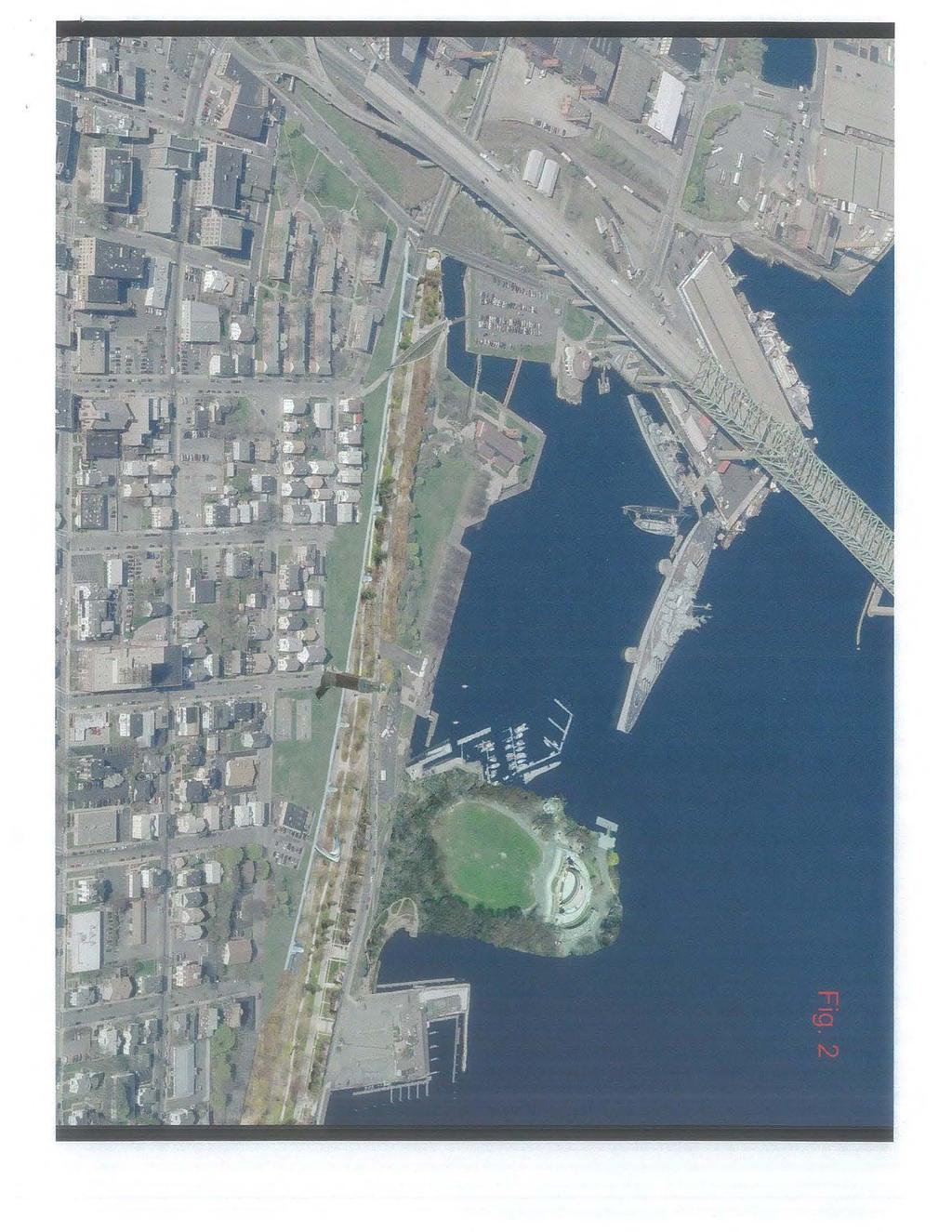
71

72
73 July 20, 2012 Pamela S. Stephenson, Division Administrator Richard K. Sullivan, Jr., Secretary Federal Highway Administration Executive Office of Environmental Affairs 55 Broadway, 10 th Floor Attn: Deirdre Buckley, MEPA Unit Cambridge, MA Cambridge Street Attention: Damaris Santiago Boston, MA Thomas F. Broderick, P.E., Chief Engineer Mass DOT Highway Division 10 Park Plaza Boston, MA Attention: Mary Hynes Via Re: EA/ENF for Route 79/I-195 Interchange Reconstruction Project EEA #: 14917, Project No Dear Ms. Stephenson, Mr. Sullivan and Mr. Broderick: On behalf of Mass Audubon I submit the following comments on the Environmental Assessment/Environmental Notification Form (EA/ENF) prepared by the Federal Highway Administration (FHA) and the Massachusetts Department of Transportation (MassDOT) for the Route 79/I-195 Interchange Reconstruction Project in Fall River (Project #605223, EEA #: 14917). Mass Audubon is committed to restoration of rivers and greenspace to improve water quality, fisheries and wildlife habitat, and neighborhoods in urban areas. We support transportation improvements that also improve environmental conditions. The proposed removal of elevated highways in the preferred at-grade alternative of this project will enhance Fall River s waterfront area and help to connect neighborhoods to the Taunton River. We recognize that MassDOT is making strides toward a greener, more sustainable approach to transportation improvements, as shown in the GreenDOT Plan. One of the Plan s goals is to improve ecological functions of water systems. As described below, further information is needed to demonstrate that the project is fully consistent with GreenDOT and local plans. The Quequechan River flows through the project area, mostly in an underground culvert until it emerges west of the railroad tracks and flows in the open to the Taunton River. The city of Fall River with the support of many residents has identified daylighting of the Quequechan as a priority goal. The Interchange project should proceed in a way that, at a minimum, does not create new obstacles to river restoration, and it should advance those efforts if possible. The EA/ENF fails to demonstrate that the project leaves the door open for future efforts to daylight 1
74 the river. It does not provide a meaningful evaluation of the feasibility of incorporating measures to restore open flow to at least a portion of the river. Therefore, we request that the EA/ENF be withdrawn and resubmitted with more complete information, or an extension be provided to accommodate public review of supplemental information. If neither of those options are undertaken, then we request that preparation of an Environmental Impact Statement (EIS) and an Environmental Impact Report (EIR) be required. Background: the Quequechan River Quequechan is a Wampanoag word for falling river. As the EA/ENF states on p. 4-1, the Quequechan River gave both its name and water power to the city. The river flows west from the South Watuppa Pond to the Taunton River. Historically it dropped steeply through a series of stunning waterfalls. Historically, portions of the river were consigned to underground pipes to make room for development at various times during the 1800s and 1900s. In 1964, to accommodate the construction of Route I-195 through the center of the city about a mile of open river between Plymouth Avenue and the Taunton River was filled or culverted and most of the waterfalls were eradicated. The EA/ENF states on p that the culverts follow the old riverbed to Battleship Cove. Overall, construction of the highway and connector ramps destroyed a significant portion of a spectacular natural resource, and it separated neighborhoods in the northern and southern sections of the city. Consistency of the Project with the Local Goal of Quequechan River Daylighting In Section 2.3 ( Project Goals ) on p. 2-4, the EA/ENF identifies the following as one of the project s goals: Remain consistent with Local, Regional and Statewide Transportation and Community Development Plans. The Commonwealth s 2002 Urban Rivers Visions Plan for Fall River recommended daylighting of the Quequechan River. The City of Fall River Master Plan includes the goal: Develop and implement a plan to restore the Quequechan River and its falls as a key element of the City s revitalization. The Fall River Energy Initiative of 2008 also identified daylighting of the Quequechan as a priority for the city. The EA/ENF states on page 5-2 that the compatibility of this project to other planned projects in the area was considered. It specifically refers to the concept of restoring open flow in portions of the Quequechan River as an example. It concludes (see Table 5-1) that the preferred at-grade alternative is consistent with local and regional plans. Most of the remainder of the document however is silent on the compatibility of the project with Quequechan River restoration. The issue is addressed only in Chapter 11 under Responses to Public Comment on p In Item 8, Restoration of the Quequechan River Falls the EA/ENF acknowledges that this issue was raised during the public meetings on this project but appears to conclude that restoration in or near the project area is not feasible, as follows: The concept to restore the historic falls of Quequechan River in the area of the interchange and historic mill buildings would involve putting Pocasset Street into a 2
75 tunnel, removal of all connecting ramps from I-195 and acquiring considerable amounts of private property. The feasibility of removing all the interchange connecting ramps to re-establish some of the water falls of the Quequechan River was discussed and evaluated during the alternatives analysis process for the Interchange Reconstruction Project. Although some of the ramps have been eliminated with the proposed Interchange Reconstruction Project, it is not feasible to remove all the ramps connecting I-195 to Route 79. The EA/ENF provides no maps, analysis or other information to support these conclusions. It does not propose any alternatives that would allow for restoration of open flow in at least portions of the river in or near the project area. We note especially that Figure 4-16 on p shows an aerial view of the project area with the location of the culverted river superimposed on the photograph. The culvert does not run under Pocasset Street in the project area; it is located to the north, between Pocasset Street and Route I-195. It is puzzling why the EA/ENF would conclude that Pocasset Street would be put into a tunnel. Analysis Requested: We request that the FHA and Mass DOT provide a more comprehensive evaluation of the compatibility of this project with daylighting of the river, that includes maps showing the original course of the river, locations of the culverts into which the river was diverted and locations where portions of the river are still visible. The evaluation should include serious consideration of areas where restoration of open flow might be feasible. We ask that you review the proposed segments of new bridge and roadway for Ramps A and E north of Pocasset Street (see Figure 3-1) to determine whether new road surface will be placed over the underground river culvert, and if so, whether a short extension of the bridge portion could avoid that result. At a minimum, the analysis should demonstrate that the Interchange project will not create new obstacles that preclude restoration of the river. We also request that you provide opportunity for the public to review and comment on this analysis. MAS 1 MAS 2 Alteration of the Quequechan Bypass Channel When I-195 was constructed, the culverted portions of the Quequechan River were connected to two existing control structures and culverts that were built under mill buildings to control the flow of water. The river can be seen at these points at the Ironworks #7 and Mill Complex Outlet control structures. The Quequechan River Bypass Channel was constructed to divert some of the river s flow from the Mill Complex control structure to Crab Pond. The preferred alternative includes a proposal to fill and reconstruct the Quequechan Bypass Channel to accommodate roadway piers for the Water Street Connector. The EA/ENF states that approximately 7400 square feet and 210 linear feet of the Channel will be altered. It indicates that the Fall River Conservation Commission determined that the Channel does not qualify as a jurisdictional wetland resource area under the Massachusetts Wetlands Protection Act, but the Army Corps of Engineers has determined that it is jurisdictional under Section 404 of the federal Clean Water Act. The EA/ENF fails to provide evaluation of the impacts and proposed mitigation for this alteration. This information should be provided. If mitigation will be MAS 3 3
76 required, we urge consideration of measures to advance restoration of open flow in the Quequechan River as that mitigation. Conclusion Overall, Mass Audubon supports this project because of overall improvements to the waterfront area. In order to demonstrate consistency of the project with the local goal of daylighting the Quequechan River, the FHA and MassDOT should consider whether there are feasible and reasonable measures to advance river restoration that might be included in this project as mitigation for wetland resource alteration. FHA and MassDOT should demonstrate at a minimum that the project does not create new obstacles that would preclude future river restoration. Therefore we request that either the EA/ENF be withdrawn and resubmitted with more complete information or an extension of the comment period be provided to accommodate submission and public review of supplemental information. If neither of those options are undertaken, we request that preparation of an Environmental Impact Statement (EIS) and an Environmental Impact Report (EIR) be required. MAS 4 Thank you for considering these comments. Sincerely, Priscilla A. Chapman Taunton Watershed Advocate Mass Audubon 1298 Cohannet Street Taunton MA cc: Mayor Will Flanagan Elizabeth Dennehy Terry Sullivan Army Corps of Engineers, New England Division Al Lima, Green Futures 4
77 (($1R ǤǡǤ ȋȍ ǣ ǡǥ14917 ͳͳͳǡͻͳͳ ͲʹͳͳͶ MassDOTRoute79/IǦ195InterchangeReconstructionProject ǡ ʹǡʹͲͳʹ OriginalviaU.S.Mail ǡ MassDOT Route 79/IǦ195 Reconstruction Project ǡ ǡǡǥ ǡǡ DzdzǤ ǡ ǡ ǣ Dz dzǥ ǦͳͻͷǤ Ǧͳͻͷ ǡ ǡ ǡǡǥ ǡ Dzdzȋ Ȍǡ ȋǧȍǧǧǥ ǦǦ ǡ ǡ Ǥ ǡ Dz dzǡ ǡ Ȁ ǡǡǥ ͳͻͳͺ ǡǡ Ǥ Dz dzǡ ǡ ǡ Ǥ Belanger 1

78 Figure A (WaterStreetConnector) (($1R Dzdzǣ ͳǥ Ǥ 2 ʹǤ ǦǦǤ Ǥ ȀǤ ͶǤ DzdzǤ ǡǥ ͷǥ ǡ Ǥ Ǥ Ǧǡ ǡǥ Ǥ ȀǦͳͻͷ ǡȋͻȁͳ ͺǦͳͻͷȌǤ ͺǤ ͳͻͳͺ Ǣǡ ȀǤ ͻǥ ǡǥ Belanger

79 (($1R ǡ ǣ DzFerry Street Connector ǡ ȀǦͳͻͷǡ ǡ ǡ Dzdz Dzdz Ǥ Figure B (FerryStreetConnector) Dz dzǣ Belanger 3 ͳǥ Ȃ ǦǦǤ ʹǤ ǡȁǡ ǤǤ Ǥ ǡ Dzdz ǡ ȀǦͳͻͷǤ ͶǤ Ǥ ͷǥ ǡ ǡ Ǥ Ǥ ǦǤǦǤ Ǥ ȀǦͳͻͷ Ǥ Ǥ ȀǤ ͺǤ ͳͻͳͺ ǡ ȀǡǡǤ ͻǥ ǡǡ Ǥ
80 ȋ ǦȌ (($1R LOCATIONS APPROXIMATE CONNECT TO PROJECT GATES OF THE CITY PLAZA NEW RAMP WITH SIDEWALK MAINTAIN GREEN SPACE MAINTAIN SIDEWALKS ALONG BROADWAY NEW RAMP WITH SIDEWALK NEW BRIDGE REPLACE EXISTING BRIDGE 4-WAY STOP TO BAY STREET EXISTING RAILROAD CROSSING
81 (($1R ǡͻȁͳͻͷ Ǥ ǡ Dzdzǡǡ ǡ ȀǦͳͻͷǤ ǡ Ǥ ͳͳ ǡͳʹͺͳ Ǥ ǣ ǡ Ǥ ǤǤ Ǥ ǡ Ǥ Ǥǡ ǤǤ ǤǤ ǡ Ǥ ǤǤ
82
83 WƌŽũĞĐƚEŽ ϲϭϱϯϯϯ DĂƐƐKdʹ,ŝŐŚǁĂLJŝǀŝƐŝŽŶ ϭϭwăƌŭwůănjă ŽƐƚŽŶ DĂƐƐĂĐŚƵƐĞƚƚƐϬϮϭϭϲ ƚƚğŷƚŝžŷ DĂƌLJ,LJŶĞƐ ŶƚŽŶĞ: ŝăɛ ϴϬ,ŽŽĚ^ƚƌĞĞƚ &ĂůůZŝǀĞƌ DĂƐƐĂĐŚƵƐĞƚƚƐϬϮϳϮϬͲϯϴϬϴ ZĞ &ĂůůZŝǀĞƌ ZŽƵƚĞϳϵ /Ͳϭϵϱ/ŶƚĞƌĐŚĂŶŐĞZĞĐŽŶƐƚƌƵĐƚŝŽŶWƌŽũĞĐƚ ĞůŽǁŝƐĂůŝƐƚŽĨĐŽŵŵĞŶƚƐƌĞŐĂƌĚŝŶŐŵLJƉƌĞůŝŵŝŶĂƌLJƌĞǀŝĞǁŽĨDĂƐƐKd ƐƉƌŽƉŽƐĞĚWƌĞĨĞƌƌĞĚƚͲ'ƌĂĚĞ ůƚğƌŷăƚŝǀğůăljžƶƚ dśğljăƌğăɛĩžůůžǁɛ ϭ dśğɖƌžɖžɛğěăůƚğƌŷăƚğɖůăŷžĩzžƶƚğϳϵ /Ͳϭϵϱ/ŶƚĞƌĐŚĂŶŐĞĚŽĞƐŶŽƚĂůůŽǁĨŽƌƚƌĂĨĨŝĐƚŽĞdžŝƚŽŶƚŽ DŝůůŝŬĞŶůǀĚ ƵƚŽŵŽďŝůĞƐǁŝůůďĞƌĞƋƵŝƌĞĚƚŽŚĞĂĚĚŽǁŶŝŶƚŽƚŚĞŶĞǁƌŽĂĚǁĂLJĞdžƚĞŶƐŝŽŶƚŽWŽĐĂƐƐĞƚ ^ƚ ƚśğŷƚžžŷŷğđƚžƌ^ƚ ƵƚŽƐƚƌĂǀĞůŝŶŐƚŚŝƐƌŽƵƚĞǁŝůůŚĂǀĞĚŝĨĨŝĐƵůƚLJĂĐĐĞƐƐŝŶŐDŝůůŝŬĞŶůǀĚ ĚƵƌŝŶŐ ůăƌőğtăƚğƌĩƌžŷƚăđƚŝǀŝƚŝğɛ WĞĚĞƐƚƌŝĂŶƐǁĂůŬŝŶŐĨƌŽŵƚŚĞ^ŽƵƚŚŶĚƚŽƚŚĞtĂƚĞƌĨƌŽŶƚĚƵƌŝŶŐƐƵĐŚ ĞǀĞŶƚƐǁŝůůďĞǁĂůŬŝŶŐĂůŽŶŐƚŚĞŶĞǁƌŽĂĚǁĂLJdžƚĞŶƐŝŽŶ dƌăĩĩŝđǁŝůůďğĩžƌđğěƚžŷăǀŝőăƚğƚśƌƶ ŝŷƚğƌɛğđƚŝžŷɛƚśăƚǁŝůůďğśğăǀljǁŝƚśɖğěğɛƚƌŝăŷɛ dśŝɛǁŝůůđƌğăƚğăďăđŭƶɖžĩđăƌɛžŷƚž/ͳϭϵϱăŷězžƶƚğ ϳϵ /ǁŽƵůĚŚŝŐŚůLJƌĞĐŽŵŵĞŶĚƚŚĂƚƚŚĞĐƵƌƌĞŶƚƌĂŵƉƚŚĂƚĞdžŝƐƚƐĨƌŽŵdžŝƚϱ /ͲϭϵϱŽŶƚŽDŝůůŝŬĞŶůǀĚ ƌğŵăŝŷŝŷɖůăđğǁŝƚśƚśğŷğǁžŷƌăŵɖŷğdžƚƚžƚśğɛğƌǀŝđğ^ƚăƚŝžŷžŷdŝůůŝŭğŷůǀě dśŝɛǁŝůůăůůžǁăđđğɛɛ ƚžƚśğ>žǁğƌ,ŝőśůăŷěɛŷğŝőśďžƌśžžěăǀžŝěŝŷőƚśğtăƚğƌĩƌžŷƚěƶƌŝŷőɖğăŭĩğɛƚŝǀğƚŝŵğɛ Dias 1 Ϯ ZĂŵƉ'ǁŝůůŶŽƚďĞĐŽŶƐƚƌƵĐƚĞĚĂƚŐƌĂĚĞĂŶĚǁŝůůĐŽŶƚŝŶƵĞƚŽďůŽĐŬĂŶLJǀŝĞǁŽĨƚŚĞĂƚƚůĞƐŚŝƉĨƌŽŵ/Ͳ ϭϵϱtğɛƚ dśŝɛƌăŵɖǁŝůůďğăŷğǁğƌǀğƌɛŝžŷžĩƚśğđƶƌƌğŷƚůăljžƶƚ ŵžƌğĩăǀžƌăďůğŵğăŷɛžĩ ĂĐĐĞƐƐŝŶŐĂǀŽů^ƚƌĞĞƚǁŽƵůĚďĞĨŽƌĂŶĞǁĞdžŝƚŽŶƚŽĞŶƚƌĂů^ƚƌĞĞƚ ĞĐĂƵƐĞƚŚŝƐŝƐƚŚĞŽŶůLJĂƌĞĂƚŚĂƚƚŚĞ>ŽǁĞƌ,ŝŐŚůĂŶĚƐEĞŝŐŚďŽƌŚŽŽĚŚĂƐƚŽĂĐĐĞƐƐƚŚĞtĂƚĞƌĨƌŽŶƚ dśğ ŝŷƚğƌăđƚŝžŷžĩɖğěğɛƚƌŝăŷɛăŷěăƶƚžŵžďŝůğɛŝɛɛƚŝůůăđžŷđğƌŷ KŶĞƉŽƐƐŝďůĞƐŽůƵƚŝŽŶǁŽƵůĚďĞƚŽ ĐŽŶƚŝŶƵĞƚƌĂĨĨŝĐŽǀĞƌƚŚĞĞŶƚƌĂů^ƚƌĞĞƚƌŝĚŐĞ dśŝɛǁžƶůěđžŷŷğđƚƚžăŷğǁğůğǀăƚğěƌžăěǁăljƚśăƚ ĐŽŶŶĞĐƚƐĂǀŽů^ƚƌĞĞƚƚŽtĂƚĞƌ^ƚƌĞĞƚ WĞĚĞƐƚƌŝĂŶƐǁŽƵůĚĂĐĐĞƐƐƚŚĞWĂƌŬďĞůŽǁƚŚĞĞůĞǀĂƚĞĚƌŽĂĚǁĂLJ Dias 2 dśğ,ğƌŝƚăőğ^ƚăƚğwăƌŭwăƌŭŝŷőůžƚǁŝůůďğğĩĩğđƚğěďljɛƶđśăɖůăŷ ƚśğƌğĩžƌğŝƚǁŝůůďğŝŵɖžƌƚăŷƚƚžǁžƌŭ ǁŝƚŚƚŚĞWĂƌŬŝŶůŽĐĂƚŝŶŐĂŶĞǁWĂƌŬŝŶŐ>ŽƚĂŶĚ ŽƌďĞĂůůŽǁĞĚƚŽƵƐĞĂŶĞǁWĂƌŬŝŶŐ'ĂƌĂŐĞƚŚĂƚĐŽƵůĚďĞ ƉƌŽƉŽƐĞĚĨŽƌƚŚĞŶĞǁDĂŝŶdƌĂŝŶ^ƚĂƚŝŽŶĂƚ,ĞƌŝƚĂŐĞ^ƚĂƚĞWĂƌŬ ^ƵĐŚĂƉůĂŶǁŝůůďĞďĞŶĞĨŝĐŝĂůƚŽďŽƚŚ,ĞƌŝƚĂŐĞ^ƚĂƚĞWĂƌŬĂŶĚƚŚĞDĂƌŝŶĞDƵƐĞƵŵ dśŝɛɖůăŷđžƶůěăůɛž ďğŷğĩŝƚžƚśğƌďƶɛŝŷğɛɛğɛăůžŷőŷăǁăŷ^ƚƌğğƚ tśŝůğƚśŝɛŝɛďğljžŷěƚśğɛđžɖğžĩƚśğŝŷƚğŷěğěɖƌžũğđƚ ŝƚžĩĩğƌɛƚśğŷğđğɛɛăƌljhƌďăŷwůăŷŷŝŷőƚśăƚǁŝůůďğƚśğěŝĩĩğƌğŷđğďğƚǁğğŷƚśŝɛɖƌžũğđƚďğŝŷőăɛƶđđğɛɛžƌ ĂĨĂŝůƵƌĞ ŶhƌďĂŶWůĂŶŶŝŶŐĞdžĞƌĐŝƐĞŽĨƚŚŝƐŵĂŐŶŝƚƵĚĞŝƐƚLJƉŝĐĂůĨŽƌĂŶLJůĂƌŐĞƐĐĂůĞƉƌŽũĞĐƚƐƵĐŚĂƐƚŚŝƐ
84 ϯ WŚĂƐŝŶŐŽĨƚŚĞƉƌŽũĞĐƚǁŝůůďĞƐƵĐŚƚŚĂƚĂƌĞĂůŝƐƚŝĐƚŝŵĞĨƌĂŵĞŽĨĂďŽƵƚϱLJĞĂƌƐƉůƵƐŵŝŶŝŵƵŵǁŝůůďĞ ŶĞĞĚĞĚƚŽĐŽŵƉůĞƚĞƚŚĞƉƌŽũĞĐƚ ŝƚljƚƌăĩĩŝđǁŝůůďğăěǀğƌɛğůljăĩĩğđƚğěǁŝƚśžƶƚăŷljđůğăƌƶŷěğƌɛƚăŷěŝŷő ŽĨĂŶLJŶĞǁƚĞŵƉŽƌĂƌLJƌŽĂĚƐŽƌƌĂŵƉƐƚŚĂƚǁŝůůďĞƌĞƋƵŝƌĞĚ dśğɖƌžɖžɛğězğǀŝɛğěwƌğĩğƌƌğěůƚğƌŷăƚŝǀğ ƉůĂŶƚŚĂƚŝƐĂƚƚĂĐŚĞĚ ĂůůŽǁƐĨŽƌŵŝŶŝŵĂůƚƌĂĨĨŝĐŝŵƉĂĐƚƐĂŶĚǁŝůůďĞůĞƐƐĐŽƐƚůLJ,ĂǀŝŶŐƚŚŝƐŶĞǁƌŽĂĚǁĂLJ ŝŷɖůăđğǁŝůůăůůžǁĩžƌăƌƶŝđŭăŷěğĩĩŝđŝğŷƚƌğŵžǀăůžĩƚśğśănjăƌěžƶɛɛɖăőśğƚƚŝƌăŵɖɛ Dias 3 dśğƌğǀŝɛğěɖůăŷǁŝůůăůɛžɖƌžǀŝěğŷğǁőƌğğŷɛɖăđğăŷěăůůžǁĩžƌƚśğɖžƚğŷƚŝăůžĩğdžɖžɛŝŷőƚśğŝƚljζɛ ǁĂƚĞƌĨĂůůƐ dśğɛğĩăůůɛǁğƌğƌğěŝƌğđƚğěƶŷěğƌőƌžƶŷěǁŝƚśƚśğđžŷɛƚƌƶđƚŝžŷžĩ/ͳϭϵϱ /ƚśăɛďğğŷƚśğőžăů ŽĨƚŚĞĐŝƚŝnjĞŶΖƐŽĨ&ĂůůZŝǀĞƌƚŽĞdžƉŽƐĞƚŚĞƐĞǁĂůůƐ ^ƵĐŚĂƉůĂŶǁŽƵůĚĂůůŽǁĨŽƌƚŚĞƐĞƌĂƉŝĚƐƚŽďĞ ĂĐĐĞƐƐŝďůĞĂŶĚƉƌŽǀŝĚĞĂŶĂĚĚŝƚŝŽŶĂůƌĞƐŽƵƌĐĞƚŽƚŚĞĂƌĞĂ ϰ dśğăƚőƌăěğěğɛŝőŷžĩƚśğŷğǁƌžăěɛljɛƚğŵǁŝůůăđƚƶăůůljđƌğăƚğŷƶŵğƌžƶɛɛžůŝěđžŷđƌğƚğďăƌƌŝğƌɛ ĚŝǀŝĚŝŶŐƚŚĞŶĞŝŐŚďŽƌŚŽŽĚƐĨƌŽŵƚŚĞtĂƚĞƌĨƌŽŶƚ KŶĞƐƵĐŚƵŶĂĐĐĞƉƚĂďůĞƌĞƚĂŝŶŝŶŐǁĂůůŝƐĂϮϬĨŽŽƚŚŝŐŚ ǁĂůůďĞƚǁĞĞŶ,ĞƌŝƚĂŐĞ^ƚĂƚĞWĂƌŬĂŶĚƚŚĞŶĞǁƌŽĂĚ dśğğdžŝɛƚŝŷőɛƚƌƶđƚƶƌğŝɛŵžƌğěğɛŝƌăďůğƚśăŷƚśğ ƉƌŽƉŽƐĞĚ ďğđăƶɛğăƚăŵŝŷŝŵăůŝƚăůůžǁɛžŷğƚžɛğğƚśƌžƶőśƚśğɛƚƌƶđƚƶƌğăŷěŝɛůğɛɛžĩăɛžůŝěďăƌƌŝğƌ dśğžŷůljěŝĩĩğƌğŷđğǁŝƚśƚśŝɛƌğǀŝɛğěůăljžƶƚŝɛƚśăƚƚśğƌžăěŝɛɛƶɖɖžƌƚğěďljŷğǁƌğƚăŝŷŝŷőǁăůůɛŝŷͳĩŝůůğě ǁŝƚŚĚŝƌƚƌĂƚŚĞƌƚŚĂŶĂƐƚĞĂůƐƚƌƵĐƚƵƌĞ dśğƌžăěɛǁŝůůďğğůğǀăƚğěĩƌžŵğŷƚƌăů^ƚƌğğƚƚžƚśğzğőăƚƚă ĐƌĞĂƚŝŶŐĂŵŽŶŽůŝƚŚŝĐĐŽŶĐƌĞƚĞƌĂŵƉƚŽ,ĞƌŝƚĂŐĞ^ƚĂƚĞWĂƌŬ ϱ dśğŷğǁƌăŵɖĩƌžŵƚśğƌžăěǁăljdžƚğŷɛŝžŷƚžtăƚğƌ^ƚƌğğƚ;wžŷƚăğůőăěăůǀě ŝɛđžŵɖůğƚğůlj ƵŶĂĐĐĞƉƚĂďůĞ,ĂǀŝŶŐĂŶĞǁƌĂŵƉĂƐƚŚĞďĂĐŬŐƌŽƵŶĚƚŽƚŚŝƐŵŽŶƵŵĞŶƚǁŝůůďĞǀĞƌLJŽĨĨĞŶƐŝǀĞƚŽƚŚĞ WŽƌƚƵŐƵĞƐĞĐŽŵŵƵŶŝƚLJĂŶĚƚŽƚŚĞ'ŽǀĞƌŶŵĞŶƚŽĨƚŚĞnjŽƌĞƐǁŚŝĐŚŐŝĨƚĞĚƚŚŝƐŵŽŶƵŵĞŶƚƚŽƚŚĞŝƚLJ dśğƌăŵɖžƌƚśğdžŷƶŵğŷƚǁŝůůŷğğěƚžďğƌğůžđăƚğě ŽƚŚĐĂŶŶŽƚĐŽͲĞdžŝƐƚǁŝƚŚƚŚĞƐĂŵĞƉůĂĐĞ ĚĚŝƚŝŽŶĂůůLJ ƚśğžŵŵƶƚğƌdƌăŝŷɖůăƚĩžƌŵƚśăƚŝɛăůɛžůžđăƚğěďğśŝŷěƚśğɛğőăƚğɛśăɛŷžƚďğğŷƚăƶőśƚ ŽƵƚ tŝƚśžƶƚăŷljăǀăŝůăďůğɖăƌŭŝŷőƚśŝɛɖůăƚĩžƌŵǁŝůůɖƌžǀŝěğƚśğŷğđğɛɛăƌljěăŝůljƶɛğžĩđžŵŵƶƚğƌɛ /Ĩ ƚśŝɛɖůăƚĩžƌŵŝɛƚžďğƶɛğěɛğăɛžŷăůůljăɛďğğŷɛƶőőğɛƚğě ƚśŝɛǁžƶůěŷžƚɖƌžǀŝěğƚśğŷğđğɛɛăƌljhƌďăŷ ĚĞǀĞůŽƉŵĞŶƚƚŚĂƚƚŚĞĞdžŝƐƚŝŶŐďƵƐŝŶĞƐƐŝŶƚŚĞĂƌĞĂǁŽƵůĚƌĞƋƵŝƌĞ dśŝɛůăđŭžĩǀŝɛŝžŷ ƉůĂŶŶŝŶŐŝƐ ĞdžƚƌĞŵĞůLJĚŝƐĂƉƉŽŝŶƚŝŶŐ /ǁŽƵůĚƌĞĐŽŵŵĞŶĚŚĂǀŝŶŐƚŚĞdƌĂŝŶƐƚĂƚŝŽŶƉůĂƚĨŽƌŵůŽĐĂƚĞĚŶĞdžƚƚŽŽŶĞŽĨ ƚśğğdžŝɛƚŝŷődŝůůƶŝůěŝŷőɛ dśğďƶŝůěŝŷőđžƶůěďğƌğŷžǀăƚğěƚžɖƌžǀŝěğăŷğŷđůžɛğěƚŝđŭğƚɛăůğɛ ǁĂŝƚŝŶŐ ĂŶĚƐŚŽƉĂƌĞĂĨŽƌƉĂƐƐĞŶŐĞƌƐ dśŝɛǁžƶůěăůůžǁĩžƌďğƚƚğƌƶɛğžĩƚśğğdžŝɛƚŝŷőɛƚƌƶđƚƶƌğɛăŷěɖƌžǀŝěğƚśğ ŶĞĐĞƐƐĂƌLJƵƌďĂŶĚĞǀĞůŽƉŵĞŶƚƚŚĞŝƚLJĚĞƐƉĞƌĂƚĞůLJŶĞĞĚƐ dśğɖůăŷŷğěŷğǁdƌăŝŷ^ƚăƚŝžŷůžđăƚğěžĩĩžĩăǀžů^ƚƌğğƚŝɛŝŷƚśğtƌžŷőůžđăƚŝžŷ dśŝɛɛƚăƚŝžŷɛśžƶůě ďğůžđăƚğěŷğăƌ,ğƌŝƚăőğ^ƚăƚğwăƌŭ ƵƐŝŶĞƐƐĞƐĐŽƵůĚďĞŶĞĨŝƚĨƌŽŵĂŽŵŵƵƚĞƌdƌĂŝŶWĂƌŬŝŶŐ'ĂƌĂŐĞ Dias 4 Dias 5 Dias 6 >ŽĐĂƚŝŶŐƚŚŝƐƚƌĂŝŶƐƚĂƚŝŽŶŝŶĂƌĞƐŝĚĞŶƚĂƌĞĂǁŝƚŚŶŽŝŶĨƌĂƐƚƌƵĐƚƵƌĞŝƐƵŶĂĐĐĞƉƚĂďůĞ ŶLJŶĞǁ ŝŷĩƌăɛƚƌƶđƚƶƌğɛśžƶůěďğěğǀğůžɖğěŝŷƚśğƌğăžĩ,ğƌŝƚăőğ^ƚăƚğwăƌŭ /ĚŽŶŽƚĂŐƌĞĞǁŝƚŚŚĂǀŝŶŐϮƚƌĂŝŶƐƚŽƉƐвŽĨĂŵŝůĞĂƉĂƌƚ tžƶůěƌğđžŵŵğŷěϭɛƚžɖăƚ,ğƌŝƚăőğ^ƚăƚğ WĂƌŬĂŶĚĂŶŽƚŚĞƌǁŝƚŚŝŶǁĂůŬŝŶŐĚŝƐƚĂŶĐĞƚŽƚŚĞ/ŶĚƵƐƚƌŝĂů ŝžɖăƌŭ ŽŵŵƵƚĞƌƐĨƌŽŵƉŽŝŶƚƐĂƐƚĂŶĚtĞƐƚĐŽƵůĚĞĂƐŝůLJĂĐĐĞƐƐƚŚĞ,ĞƌŝƚĂŐĞWĂƌŬdƌĂŝŶƐƚĂƚŝŽŶŽĨĨŽĨ/Ͳϭϵϱ ĂŶĚƉĂƌŬĂƚĂŐĂƌĂŐĞǁŝƚŚŽƵƚŶĞĞĚŝŶŐƚŽƚƌĂǀĞůĂŶĂĚĚŝƚŝŽŶĂůϯ ϰžĩăŵŝůğ
85 ^ƚăƚŝžŷăƚ,ğƌŝƚăőğ^ƚăƚğwăƌŭǁžƶůěśăǀğğdžŝɛƚŝŷőďƶɛŝŷğɛɛƚśăƚđăŷɛƶɖɖžƌƚăŷğǁdƌăŝŷ^ƚăƚŝžŷ ŝŵŵğěŝăƚğůlj dśğůăƚƚğƌǁžƶůěśăǀğƚžěğǀğůžɖƚśğɛğƚljɖğɛžĩďƶɛŝŷğɛɛğɛžǀğƌƚŝŵğ ϲ dśğƌğŷğğěɛƚžďğăđžžƌěŝŷăƚğěğĩĩžƌƚďğƚǁğğŷƚśğzžƶƚğϳϵ /ͲϭϵϱŝŶƚĞƌĐŚĂŶŐĞĂŶĚƚŽƚŚĞ ŶĞŝŐŚďŽƌŚŽŽĚƌĞƋƵĞƐƚĞĚƉůĂŶƚŽĞůŝŵŝŶĂƚŝŽŶZƚ ϳϵĨƌŽŵĞŶƚĞƌ^ƚƌĞĞƚƚŽƚŚĞsĞƚĞƌĂŶ ƐDĞŵŽƌŝĂůƌŝĚŐĞ dśŝɛɖůăŷɖƌžǀŝěğɛăƚƌğğůŝŷğěďžƶůğǀăƌěǁśğƌğzƚ ϳϵŝƐĐƵƌƌĞŶƚůLJůŽĐĂƚĞĚ dśğŝŵɖůŝđăƚŝžŷɛăƌğƚśăƚƚśğɖƌžɖžɛğěŵăŝŷdƌăŝŷɛƚăƚŝžŷθɖăƌŭŝŷőőăƌăőğ ůžđăƚğěžĩĩžĩăǀžů^ƚƌğğƚ ŶŽƌƚŚǁŽƵůĚďĞŝŶĐŽŶĨůŝĐƚǁŝƚŚƚŚĞďŝŬĞƉĂƚŚĂŶĚƉĞĚĞƐƚƌŝĂŶďŽƵůĞǀĂƌĚ dśğďžƶůğǀăƌěƌğƌƶğɛƚğěďlj ƚśğŷğŝőśďžƌśžžěǁžƶůěƌğƌƶŝƌğƚśăƚƚśğdăŝŷdƌăŝŷɛƚăƚŝžŷďğůžđăƚğěăƚ,ğƌŝƚăőğ^ƚăƚğɖăƌŭ dśğ ĐƵƌƌĞŶƚŝŶƚĞƌĐŚĂŶŐĞƉůĂŶƉƌŽƉŽƐĞĚďLJDĂƐƐKdĚŽĞƐŶŽƚƚĂŬĞƚŚŝƐƐĐĞŶĂƌŝŽŝŶƚŽĐŽŶƐŝĚĞƌĂƚŝŽŶ ϳ ƚƚăđśğěŝɛăƌğǀŝɛğěɖůăŷěŝƌğđƚŝŷőƚƌăĩĩŝđĩƌžŵƌžăěǁăljƚžtăƚğƌ^ƚƌğğƚƚśğŷđžŷŷğđƚŝŷőƚžăǀžů ^ƚƌğğƚžǀğƌƚśğđƶƌƌğŷƚɖăƌŭŝŷőůžƚĩžƌ,ğƌŝƚăőğ^ƚăƚğwăƌŭ dśŝɛɖůăŷǁžƶůěăůůžǁĩžƌğăɛŝğƌɖğěğɛƚƌŝăŷ ĨůŽǁĨƌŽŵƚŚĞĞŶƚƌĂůƐƚƌĞĞƚĂƌĞĂĚŽǁŶƚŽƚŚĞǁĂƚĞƌĨƌŽŶƚǁŝƚŚŽƵƚƚŚĞŶĞĞĚĨŽƌĂƉĞĚĞƐƚƌŝĂŶďƌŝĚŐĞ KƚŚĞƌĂĚǀĂŶƚĂŐĞƐŽĨƚŚŝƐƉůĂŶŝƐƚŚĂƚƚŚĞYƵĞƋƵĞĐŚĂŶZŝǀĞƌ ǁŚŝĐŚŝƐĐƵƌƌĞŶƚůLJĐŽǀĞƌĞĚŽǀĞƌďLJƚŚĞ ďƌŝěőğĩƌžŵƚśğƌžăěǁăljğdžƚğŷɛŝžŷƚžăǀžů^ƚƌğğƚ ǁŽƵůĚďĞĞdžƉŽƐĞĚ dśğƌžăěǁăljğdžƚğŷɛŝžŷđăŷ ďğğůŝŵŝŷăƚğěđžŵɖůğƚğůljăŷěƚśŝɛůăŷěđăŷďğƶɛğěăɛğŝƚśğƌőƌğğŷɛɖăđğžƌěğǀğůžɖăďůğůăŷě Dias 7 ŶĂĚǀĂŶƚĂŐĞƚŚĂƚƚŚŝƐĂůƚĞƌŶĂƚĞƉůĂŶƉƌŽǀŝĚĞƐŝƐƚŚĂƚŝƚĐŽƵůĚďĞĐŽŶƐƚƌƵĐƚĞĚĂŶĚŝŶƵƐĞǁŝůůƚŚĞŽůĚ ƌžăěǁăljɛljɛƚğŵŝŷɖůăđğ dśŝɛɖůăŷǁžƶůěďğƚśğŵžɛƚđžɛƚğĩĩğđƚŝǀğěğɛŝőŷžĩƚśğŵăůůăŷěăƚƚśğɛăŵğ ƚŝŵğɖƌžǀŝěğŷğǁğŷğƌőljăŷěőƌžǁƚśžɖɖžƌƚƶŷŝƚŝğɛƚžƚśğƶɛŝŷğɛɛğɛžŷƚśğtăƚğƌĩƌžŷƚ DĂŶLJŽĨƚŚĞŝĚĞĂƐůŝƐƚĞĚĂďŽǀĞĂƌĞďĞLJŽŶĚƚŚĞƐĐŽƉĞŽĨƚŚŝƐƉƌŽũĞĐƚ ďƶƚƚśăƚŝɛǁśăƚŝɛƌğƌƶŝƌğěƚžśăǀğ ĂƐƵĐĐĞƐƐĨƵůƉƌŽũĞĐƚ tśăƚśăɛďğğŷɖƌğɛğŷƚğěŝɛǀžŝěžĩăŷljɖůăŷŷŝŷőžƌƶŷěğƌɛƚăŷěŝŷőžĩƚśğ ŶĞŝŐŚďŽƌŚŽŽĚƐ ŽƚŚĞƌŽŶŐŽŝŶŐƐƚƵĚŝĞƐŽƌƐĂĨĞĂĐĐĞƐƐƚŽƚŚĞtĂƚĞƌĨƌŽŶƚ,ŽǁĚŽĞƐŽŶĞƚƌĂŶƐŝƚŝŽŶĨƌŽŵ ƚśğŷğŝőśďžƌśžžěƚžƚśğtăƚğƌĩƌžŷƚ tśăƚŝɛƚśğğdžɖğƌŝğŷđğ dśğŵžɛƚɛƶđđğɛɛĩƶůƶƌďăŷɖůăŷɛăƌğ ĚĞǀĞůŽƉĞĚǁŚĞŶƚŚĞƌĞŝƐŐƌĞĂƚĐĂƌĞŝŶƚŽƚŚĞĞdžŝƐƚŝŶŐƵƌďĂŶĨĂďƌŝĐ dśŝɛƌğɛɖğđƚĩžƌğdžŝɛƚŝŷőĩăďƌŝđ ƌğŝŷĩžƌđğɛƚśğďžŷěɛƚśăƚƚŝğƚśğđžŵŵƶŷŝƚljƚžőğƚśğƌ Dias 8 dśğɖƌžɖžɛğězžƶƚğϳϵ /ͲϭϵϱŝŶƚĞƌĐŚĂŶŐĞƉůĂŶĚŽĞƐŶŽƚƉƌŽǀŝĚĞĂŶLJŽĨƚŚĞƐĞĐŽŶŶĞĐƚŝŽŶƐŽƌ ĞdžƉĞƌŝĞŶĐĞƐ tśăƚdăɛɛkdśăɛɖƌžǀŝěğě&ăůůzŝǀğƌǁŝƚśŝɛăŷğŷőŝŷğğƌŝŷőğdžğƌđŝɛğ ǁŚĞŶǁŚĂƚŝƚƌĞĂůůLJ ŶĞĞĚƐŝƐĂŶhƌďĂŶWůĂŶ /ĂƐŬƚŚĂƚLJŽƵƉůĞĂƐĞŐŽďĂĐŬƚŽƚŚĞĚƌĂǁŝŶŐďŽĂƌĚĂŶĚƉƌŽǀŝĚĞĂƉůĂŶƚŚĂƚǁŝůů ĞŶŚĂŶĐĞŽƵƌtĂƚĞƌĨƌŽŶƚĂŶĚƉƌŽǀŝĚĞƚŚĞŶĞĐĞƐƐĂƌLJĐŽŶŶĞĐƚŝŽŶƐƚŚĂƚǁĞƐŽĚĞƐƉĞƌĂƚĞůLJŶĞĞĚ ^ŝŷđğƌğůlj ŶƚŽŶĞ: ŝăɛ ƚƚăđśŵğŷƚɛ ZĞǀŝƐĞĚWƌĞĨĞƌƌĞĚůƚĞƌŶĂƚŝǀĞ ƚͳ'ƌăěğůƚğƌŷăƚŝǀğwůăŷsŝğǁ
86

87 KEY NEW SIGNAL (INTERSECTIONS ARE NUMBERED FOR REFERENCE IN TEXT) NEW ROADWAY CONSTRUCTION NEW BRIDGE NEW OR IMPROVED SIDEWALK NEW SHARED USE PATH TRAFFIC DIRECTION PROPOSED RAMP ID
88
89 From: Sent: Friday, July 20, :55 PM To: Hynes, Mary E. (DOT) Subject: Route 79/I-195 InterchangeReconstruction Project, Project File No Greetings, I have attended two meetings concerning this area of Fall River, one was held on June 16 at Government Center, the other was the public hearing at Heritage State Park on July 12. Those making the presentation on July 12 seemed to be unfamiliar with the long range vision for the city, for the development of the waterfront, improved accessibility to city residents and promotion of tourism. Had I not attended that meeting I might have been more receptive to the proposals of July 12. I do hope those involved will take into consideration the creation of a greenway between the north and south portions of Rte. 79/Davol Street north of Central Street by overlaying the new construction on the present Davol street locations or closer to the park and Mass Coastal Railroad if possible. Granted, the northern end of the configuation would need to meet the existing widths to connect with the portions of Davol St.and Rte 79 not being upgraded at this time. If the present plan is implemented it would eliminate the possibility of the pedestrian bridge to that area and a future bike and walking path to eventually connect with the Veterans Bridge.and perhaps in the next stage from the Greenway to the Waterfront. Margolies 1 The project as proposed will be a tremendous improvement of the present situation, but it falls short of the vision to allow for future development. As was stressed in the presentation, this structure is going to be lower maintainance and last a long time. Let it be a project that also has a plan for the future so that people will not look back in 10 years and say if only this or that had been done, now we could do thus and so... Marian S. Margolies - Citizen of Fall River, Member of the Lower Highlands Historical Neighborhood Association 750 Davol St., Unit 1013 Fall River, MA 02720
90
91 THE COMMONWEALTH OF MASSACHUSETTS MASSACHUSETTS DEPARTMENT OF TRANSPORTATION HIGHWAY DIVISION ACCELERATED BRIDGE PROGRAM Fall River, MA Route 79/I -195 Interchange Reconstruction Project Project File No This sheet is provided for your comments. Your input is solicited and appreciated. Please return your sheet, with comments, to the three addresses listed on the previous page: The final date for receipt of written statements and exhibits for inclusion into the official hearing transcript will be ten (10) days after the Public Hearing. PLEASE TYPE OR PRINT LEGIBLY. Meade 1 ~OU\) ~ ~ pikjaei=>- ~ ~?b--< d f21 &c_ ifu! a>atf'ecbt:o Vl ") Meade 2 Meade 3
92
93 THE COMMONWEALTH OF MASSACHUSETTS MASSACHUSETTS DEPARTMENT OF TRANSPORTATION HIGHWAY DIVISION ACCELERATED BRIDGE PROGRAM Fall River, MA Route 79/I-195 Interchange Reconstruction Project Project File No This sheet is provided for your comments. Your input is solicited and appreciated. Please return your sheet, with comments, to the three addresses listed on the previous page: The final date for receipt of written statements and exhibits for inclusion into the official hearing transcript will be ten (1 0) days after the Public Hearing. PLEASE TYPE OR PRINT LEGIBLY. Rodgers 1 Rodgers 2 Rodgers 3 Name: Organization: cp~~~~--'~r4z:t& ~~~~~~~r-----.!s~~----'~lw Address: --~~--~~~==~--~~==~----~~~--~~
94
95 ͳǡʹͳͳʹ E:CommentsonRoute79/IǦ195InterchangeReconstructionProject ToWhomItMayConcern, ǡ Ǥǣ Re:JacobsConcerns x ThefourlanestretchofviaductʹǢ ǫǧ ǫǥǥ ǡǥǡ ǡǧ Ǥ x Lights: ǡǥ ǡǡǥǡ ǡǡ Ǥ ǡ ǤǡǤ x Complexitiesofhighways: Ǥǡ ǡ Ǥǡ ǡ Ǥǡ ǡǡǥ ǦǤǡ ǡ Ǧ Ǧʹͳ ǫ ǡͳͻͷͳ Ǥ Re:City srelated(notjacobs) x ǡǥ ǡ ǡǥǧ ǡǥǡǡ ǡǡ ǡǥ x ǡǡǡǡ Ǥǡ ǡǥ ǡDzǡdz ǡǡ Ǥ ǡǡ ǦǦǤǡ Ǥ Delany 1 Delany 2 Delany 3 Delany 4 Delany 5
96 x x x ǡǥǡ ǡǥ ǡǧǡ ǡȁǡǡǡǡ ǡǡ Ǧǡ ǡǧͳͷǡͳͳͳǡ ʹͷǦ ʹͶǡͷͲΪ ǡǡ ʹͲ Ͳǡǫ ǡǡǡ Ǥǡǡ Ǥǡ Ǥ ǡǡ Ǧǡ ǦǦ Ǥǡ ǡ Ǥ Ǥǡ ǡǡ ǤȋȌ ǡǡǡ ȋȍ Ǥ DeadǦendroads:ǡDzǡdz Ǧ Ǥ ǡǧǥ ǯǡ Ǥ ͻ Ǥ Ǧǡ Ǥ Insummary,Ǧǡ ȋǧȍ Ǥ ǡǥ ǡ Delany 6
97 SECTION 4 Public Hearing Transcript This section contains the transcript from the July 12, 2012 Public Hearing.
98
99 '(6,*138%/,&+($5,1* -8/< $7 +(5,7$*(67$7(3$5. '$92/675((7 )$//5,9(50$66$&+86( )257+( (19,5210(17$/$66(660(172)7+( (' )$//5,9(55287(,,17(5&+$1*(5(&216758&7,21352-(&7 352-(&712,17+(&,7<2))$//5,9(50$66$&+86(776 &20021:($/7+2)0$66&+86(776 0$66$&+86(776'(3$570(172)75$163257$7,21 +,*+:$<',9,6,21 )5$1&,6$'(3$2/$3( $'0,1,675$725+,*+:$<',9,6, $6)%52'(5,&.3( &+,()(1*,1((5
100 35(6(17(56 $P\*HWFKHOO3URMHFW0DQDJHU 0DVV'27±+LJKZD\'LYLVLRQ 5RG(PHU\ -DFREV(QJLQHHULQJ*URXS 0DU\DQQ0DJQHU -DFREV(QJLQHHULQJ*URXS 6WHYHQ&DPDUD /RZHU+LJKODQGV+LVWRULF'RZQWRZQ1HLJKERUKRRG $VVRFLDWLRQ 63($.(5,1'(; 1$0( 3$*( $0<*(7&+(// 52'(0(5< 0$5<$110$*1(5 67(9(1&$0$5$ (;+,%,76 '(6&5,37,21 3$*( 6,*1,16+((7 ± 38%/,&&200(17 38%/,&+$1'287 $70,1&&RXUW5HSRUWLQJ6HUYLFHV
101 352&((',1*6 $0<*(7&+(//*RRGHYHQLQJHYHU\ERG\7KDQN\RXDOO IRUFRPLQJRXWWRQLJKW0\QDPHLV$P\*HWFKHOODQG,DPD SURMHFWPDQDJHUIRUWKH)DOO5LYHU5RXWH,,QWHUFKDQJH 5HFRQVWUXFWLRQ3URMHFWXQGHUWKH0DVV'27VDFFHOHUDWHGEULGJH SURJUDP 7KHDFFHOHUDWHGEULGJHSURJUDPEHJDQLQDQGLWVDQ HLJKW\HDUELOOLRQGROODUSURJUDPWRUHKDELOLWDWHUHSDLUDQG UHSODFHVWUXFWXUDOO\GHILFLHQWEULGJHVWKURXJKRXWWKH &RPPRQZHDOWK 7KH)DOO5LYHU5RXWH,,QWHUFKDQJH5HFRQVWUXFWLRQ 3URMHFWLVFXUUHQWO\SURJUDPPHGIRUDWRWDORIPLOOLRQ GROODUVDQGDFRQVWUXFWLRQEXGJHWRIPLOOLRQGROODUVZLWK HOLJLELOLW\IRUXSWRSHUFHQWUHLPEXUVHPHQWRIIXQGVIURP )HGHUDO+LJKZD\ 7RQLJKWVPHHWLQJZDVDGYHUWLVHGLQWKH%RVWRQ*OREHDQG WKH+HUDOG1HZVRQ-XQHWKDQG-XO\WKDQGWKH 3RUWXJXHVH7LPHVRQ-XQHWKDQG-XO\,ZDQWWRWDNH DPRPHQWWRQLJKWWRUHFRJQL]HRXUHOHFWHGRIILFLDOVZKRDUHLQ WKHURRP:HKDYH5HSUHVHQWDWLYH6FKPLGKHUHZLWKXVWKLV HYHQLQJDVZHOODV/LVD/RZQH\IURP&RQJUHVVPDQ%DUQH\)UDQNV RIILFHEDFNWKHUHLQWKHFRUQHU7KDQN\RXERWKIRUFRPLQJWKLV HYHQLQJ $VUHTXLUHGE\6WDWHDQG)HGHUDOVWDQGDUGV0DVV'27KDV ILOHGDQHQYLURQPHQWDOQRWLILFDWLRQIRUPZKLFKZHUHIHUWRDV $70,1&&RXUW5HSRUWLQJ6HUYLFHV
102 (1)XQGHUWKH0DVVDFKXVHWWV(QYLURQPHQWDO3ROLF\$FWDVZHOODV DQHQYLURQPHQWDODVVHVVPHQWZKLFKZHW\SLFDOO\FDOODQG($ XQGHUWKH1DWLRQDO(QYLURQPHQWDO3ROLF\$FW 7KLV($(0)GRFXPHQWZDVILOHGZLWKWKH0DVVDFKXVHWWV ([HFXWLYH2IILFHRI(QYLURQPHQWDO$IIDLUVDQG)HGHUDO+LJKZD\ $GPLQLVWUDWLRQRQ-XQH7KHSXEOLFFRPPHQWSHULRGUXQV IURP-XQHWKURXJK-XO\ 0DVV'27HQFRXUDJHVWKHSXEOLFWRVXEPLWZULWWHQFRPPHQWVRQ WKH($(0)GRFXPHQW7KHDGGUHVVHVIRUPDLOLQJRUHPDLOLQJ\RXU FRPPHQWVDUHLQWKHSURMHFWKDQGRXWWKDW\RXUHFHLYHGWRQLJKW,I\RXGLGQWUHFHLYHDKDQGRXWSOHDVHJUDERQHRQ\RXUZD\ RXW 7KHSXUSRVHRIWRQLJKWVPHHWLQJLVWRSUHVHQWWKH5RXWH,,QWHUFKDQJH5HFRQVWUXFWLRQ3URMHFWDVZHOODVWDNH\RX WKURXJKWKH($GRFXPHQWKLJKOLJKWLQJWKHVWHSVWDNHQWRVHOHFW 0DVV'27VSUHIHUUHGDOWHUQDWLYH7KHVHFRQGKDOIRIWKH SUHVHQWDWLRQWRQLJKWZLOOIRFXVRQWKHLQGLYLGXDOHQYLURQPHQWDO LPSDFWWKDWLVUHTXLUHGWREHUHYLHZHGWKURXJKWKH($SURFHVV 2XUXOWLPDWHJRDOLVWRUHFHLYHD6HFUHWDU\&HUWLILFDWH IURPWKHRIILFHRI(QHUJ\DQG(QYLURQPHQWDO$IIDLUVDVZHOODV D5HFRUGRI'HFLVLRQIURP)HGHUDO+LJKZD\LQWKHIRUPRID )216,ZKLFKLVD)LQGLQJRI1R6LJQLILFDQW,PSDFW 6RKHUHVRXUDJHQGDWKLVHYHQLQJ:HUHMXVWJRLQJWRUXQ WKURXJKWKHEDFNJURXQGRIWKHSURMHFWWKHSXUSRVHDQGQHHG VWDWHPHQWRIWKH($ZHOOUXQWKURXJKRXUSUHIHUUHG $70,1&&RXUW5HSRUWLQJ6HUYLFHV
103 DOWHUQDWLYHWKHHYDOXDWLRQWKHHQYLURQPHQWDOLPSDFWDVZHOO DVFRQVWUXFWLRQRYHUYLHZDQGWKHQH[WVWHSV 6RKHUHVZKHUHZHDUHLQWKHSURFHVV:HDUHFXUUHQWO\LQ VWHSVIRXUILYHDQGVL[7RQLJKWZHUHZRUNLQJRQWKH0(3$ DQGWKH1(3$SHUPLWWLQJSURFHVV:HUHDOVRLQWKHPLGGOHRI SUHSDULQJRXUSHUFHQWGHVLJQGUDZLQJVDVZHOODVRXUVNHWFK SODQVIRUDOOWKHEULGJHVWUXFWXUHV:HUHDOVRLQWKH EHJLQQLQJVWDJHVRIDGYHUWLVHPHQWIRUSURFXUHPHQWIRUDGHVLJQ EXLOGWHDP 6RMXVWDOLWWOHEDFNJURXQGRQWKHSURMHFW7KHSURMHFW ZLOODOORZ0DVV'27WRUHPRYHVWUXFWXUDOO\GHILFLHQWEULGJHV IURPWKHRYHUDOOOLVW6WUXFWXUDOO\GHILFLHQWPHDQVWKHEULGJH GHFNZKLFKLVWKHGULYLQJVXUIDFHWKHVXSSRUWEHDPVEHQHDWK WKHGHFNRUWKHVXSSRUWLQJFROXPQVRUSLHUVKDYHEHHQUDWHGLQ SRRUFRQGLWLRQDQGQHHGUHSDLU:HOOWKHEULGJHPD\EH VWUXFWXUDOO\GHILFLHQWLWLVVWLOOVDIHWRGULYHRYHUDQG XQGHU,Q-DQXDU\RI0DVV'27FRQYH\HGDWDVNIRUFHPDGHXS RIVWDNHKROGHUVIURP)DOO5LYHUDQGWKHUHJLRQ7KHWDVNIRUFH ZDVDVVHPEOHGLQDQDGYLVRU\UROHWRGLVFXVVZLWK0DVV'27WKH NH\JRDOVRIWKHSURMHFWWKH5RXWHUHSODFHPHQWDOWHUQDWLYHV DQGWRSURYLGHIHHGEDFNDQGFRPPHQWVRQWKHRYHUDOOSURMHFW )HGHUDO+LJKZD\LVDQDFWLYHSDUWLFLSDQWLQWKHRYHUDOO SURMHFWGHYHORSPHQWDQGFRQVWUXFWLRQWRHQVXUHUHJLRQDO WUDQVSRUWDWLRQPRELOLW\LVQRWFRPSURPLVHG $70,1&&RXUW5HSRUWLQJ6HUYLFHV
104 7KH$%3SURJUDPDOORZV0DVV'27IOH[LELOLW\LQWKH SURFXUHPHQWDQGFRQVWUXFWLRQSURFHVVWRHQVXUHWKDWSURMHFWVDUH GHOLYHUHGRQWLPHDQGRQEXGJHW:HUHZRUNLQJWRSURYLGH PXOWLPRGHWUDQVSRUWDWLRQXVHFRPSO\ZLWKWKH*UHHQ'RW LQLWLDWLYHVSURYLGHORZLPSDFWGHYHORSPHQWDVZHOODVFRQWDFW VHQVLWLYHGHVLJQ 6RWKHSURFXUHPHQWSURFHVVIRUWKLVSURMHFWZLOOIROORZWKH GHVLJQEXLOGDSSURDFKXVLQJDVVHVVHGYDOXHVHOHFWLRQ:HUH FXUUHQWO\LQ3KDVH2QHRIWKDWSRUWLRQRISURFXUHPHQWDQGKDYH DGYHUWLVHGIRUOHWWHUVRILQWHUHVW7KRVHOHWWHUVRILQWHUHVW DUHGXHWRXVQH[WZHHN 7KLVVWHSDOORZVWKHFRQWUDFWRUVRUGHVLJQHUVWRVXEPLWD OHWWHUWR0DVV'27VWDWLQJWKDWWKH\UHLQWHUHVWHGLQZRUNLQJRQ WKLVSURMHFW 7KHVHFRQGVWHSLVIRUXVWRUHOHDVHWKHUHTXHVWIRU TXDOLILFDWLRQVZKLFKZHFDOOWKH5)4WRDOOWKHSDUWLHVWKDW VXEPLWWHGDOHWWHURILQWHUHVW%\ODWH$XJXVWWKHFRQWUDFWRUV DQGGHVLJQHUVZLOOIRUPWKHLUGHVLJQEXLOGWHDPVDQGVXEPLW WKHLUVWDWHPHQWVRITXDOLILFDWLRQVNQRZQDVWKH624 )URPWKLVSRLQW0DVV'27VVHOHFWLRQFRPPLWWHHZLOOVKRUW OLVWDSSUR[LPDWHO\WKUHHGHVLJQEXLOGWHDPVWRPRYHLQWRWKH VHFRQGSKDVHRISURFXUHPHQW3KDVHWZRFRQVLVWVRIWKHUHOHDVH RIUHTXHVWIRUSURSRVDOVDOORZLQJXVWRPRYHLQWRWKHILQDO SKDVHRIDZDUGLQJWKHFRQWUDFWDQGLVVXLQJDQRWLFHWRSURFHHG 7KHQRWLFHWRSURFHHGLVVFKHGXOHGWREHLVVXHGLQHDUO\ $70,1&&RXUW5HSRUWLQJ6HUYLFHV
105 ZLWKDSURMHFWFRPSOHWLRQGDWHRIIDOO%HIRUH,WXUQWKH SUHVHQWDWLRQRYHUWRRXUFRQVXOWDQW-DFREV,ZDQWWRUHPLQG HYHU\RQHWRSOHDVHVLJQLQ,I\RXKDYHQWSOHDVHGRVRRQ \RXUZD\RXW,DVNWKDW\RXKROG\RXUTXHVWLRQVRUFRPPHQWV XQWLOWKHHQG:HUHJRLQJWROHDYHSOHQW\RIWLPHIRU HYHU\ERG\WRFRPPHQW :HKDYHDVWHQRJUDSKHUIURP$UOLQJWRQ7\SLQJKHUHZLWKXV WRQLJKWVRZKHQ\RXGRKDYH\RXUTXHVWLRQVDQGFRPPHQWVZHDVN WKDW\RXSOHDVHVWDWH\RXUQDPHFOHDUO\IRUWKHUHFRUG :LWKWKDW,PJRLQJWRWXUQLWRYHUWR5RGZKRZLOOJLYH \RXDOLWWOHEDFNJURXQGRQWKHSURMHFW 52'(0(5<,PJRLQJWRUHYLHZWKHSUHIHUUHGDOWHUQDWLYH IRUDTXLFNPLQXWH,WVVRPHWKLQJWKDWZHKDYHVRUWRIEHHQ UROOLQJZLWKDQGZHUHILQGLQJDVZHJR,WZLOOORRNIDPLOLDU WRDORWRISHRSOHZKRKDYHVHHQWKLVEHIRUHDQGIRUWKH QHZFRPHUVDWOHDVWZHOOJRWKURXJKWKHVWHSVWKDWOHGXVWR WKLVSUHIHUUHGDOWHUQDWLYH 7KHEDVLFSUHPLVHRIWKHSURMHFWDV$P\VDLGLVWR HOLPLQDWHVWUXFWXUHV7KHPDLQYLDGXFWWKDWPDNHV5RXWHDV LWLQWHUFKDQJHVZLWKZLOOEHUHPRYHGVRWKHVRUWRIPDLQ VWHLQRI5RXWHZKLFKLVLQDYLDGXFWLWVDFWXDOO\DWZR OHYHOYLDGXFWRQ5RXWHZLOOEHUHPRYHG :HKDYHWKDWZLOOFUHDWHDWJUDGHURDGZD\VDQGDWJUDGH LQWHUVHFWLRQV7KHDOLJQPHQWZLOOFRQVLVWRIEDVLFDOO\DIRXU ODQHURDGZD\EHWZHHQVLJQDOL]HGLQWHUVHFWLRQVDORQJWKH $70,1&&RXUW5HSRUWLQJ6HUYLFHV
106 FRUULGRU,WVDWLJKWILWDURXQG$QDZDQ6WUHHWDQG&HQWUDO 6WUHHWVRLWZDVDUHDOSURFHVVWKDWZHZHQWWKURXJKWRPDNHLW ZRUNIURPWKHWUDIILFSRLQWRIYLHZ $QDZDQ6WUHHW&HQWUDO6WUHHWDUHQHZVLJQDOL]HG LQWHUVHFWLRQVLQWKHFRUULGRUYHU\LPSRUWDQWWRWKHSURMHFW 7KDWV&HQWUDO6WUHHWLQGLFDWLQJ2QHRIWKHIHDWXUHVWKDWZH GLGQWKDYHLQRXURULJLQDOGHVLJQZDVWKHVRFDOOHG:DWHU 6WUHHW&RQQHFWRU,WVDQHZURDGZD\WKDWFRQQHFWVWKHPDMRU LQWHUVHFWLRQIURP5RXWHGRZQWRWKHZDWHUIURQWDQGPRUH LPSRUWDQWO\ZLOOFRQQHFWIURP5RXWHXSWRWKHVSDJKHWWL UDPSVDQGXOWLPDWHO\WR $OOWKHWUDIILFWKDWVRQ5RXWHWKDWVKHDGHGIRUWKH LQWHUVWDWHDQGDOOWKHWUDIILFWKDWJRHVWKURXJKORFDOO\KDYHWR JRWKURXJKWKLVLQWHUVHFWLRQVRWKLVLVDYHU\KLJKYROXPH LQWHUVHFWLRQDQGSURYLGHXVQHZDFFHVVGRZQWRWKHZDWHUIURQW 0LOOLNHQ&RQQHFWRUZKHUHWRGD\WKHUHLVDQRIIUDPSIURP WKHVSDJKHWWLUDPSVIURPGRZQWR0LOOLNHQ%RXOHYDUGZKLFK UXQVDWWKHVLGHRIWKH&%':HDUHSURSRVLQJWRDGGDQHZ UDPSZKLFKZRXOGFRQQHFWIURP0LOOLNHQEDFNXSWR (OLPLQDWHDUDPSRYHUKHUHLQGLFDWLQJZKLFKLVFDOOHG5DPS/ IURP&HQWUDO6WUHHWWR7KLVWDNHVLWVSODFH :HKDGDORWGLVFXVVLRQDERXWKRZWRPDNHWKDWLQWHUVHFWLRQ ZRUNDQGDQHZIHDWXUHRIWKLVSUHIHUUHGDOWHUQDWLYHZDV LQLWLDWHGZKLFKLVFDOOHGWKHFRQQHFWRUVWUHHW 6RWRUHSODFHWKHPRYHPHQWWKDWWRGD\LVPDGHRQWKHRII $70,1&&RXUW5HSRUWLQJ6HUYLFHV
107 UDPSFRPLQJRIIRIDQGPDNLQJDOHIWGRZQWR0LOOLNHQ %RXOHYDUGZRXOGEHSURKLELWHGEHFDXVHRIVLJKWGLVWDQFHLVVXHV 6WRSSLQJWUDIILFRQDFXUYHGUDPSFRPLQJRIIRI\RXZRXOG SURFHHGGRZQWKHUDPSWRDVHULHVRIULJKWWXUQVRQ3RFDVVHW 6WUHHWDQGWKHQUHWXUQWR0LOOLNHQ%RXOHYDUGWKURXJKWKLVQHZ FRQQHFWRUURDG2QHRIWKHQHZIHDWXUHVRIWKHSUHIHUUHG DOWHUQDWLYHDV,VDLGLWVEHLQJSURJUHVVHGDQGUHYLVHGDVZH JR 7KLVLVWKHUDPSIURP&HQWUDO6WUHHWWKDW,ZDVWDONLQJ DERXW:KHQZHWDONDERXWWKH($SURFHVVDVRSSRVHGWRWKH0(3$ SURFHVVZKHUHZHZHUHWKLVDIWHUQRRQZHKDGWRVWDUWZLWKD SXUSRVHDQGQHHGIRUWKHSURMHFWDQGSUHSDUHWKHDOWHUQDWLYHV WKDWZHFRPHXSZLWKWRWKDWSXUSRVHDQGQHHG 1XPEHURQHWKHELJRQHRQWKHWRSOLVWLVWRDVVHVVWKH VWUXFWXUDOGHILFLHQF\RIWKHSURMHFW$P\DOOXGHGWRWKHIDFW WKDWWKHUHZHUHEULGJHVWUXFWXUHVWKHUHDUHDFWXDOO\RYHU VTXDUHIHHWRIEULGJHGHFNLQWKLVLQWHUFKDQJH IHHWRIOLQHDUUDPSV 7KHQXPEHURIVTXDUHIHHWRIEULGJHGHFNLVJRLQJIURP DERXWGRZQWROHVVWKDQRUDURXQGVR DERXWWZRWKLUGVRIWKHUHGXFWLRQLQDUHDRIVWUXFWXUDOGHFNVLQ WKHFRPSOHWHGGHVLJQ,WKLQNLWVDERXWDQSHUFHQW UHGXFWLRQLQWKHOHQJWKRIEULGJHVWUXFWXUHVRWKHUHVD VLJQLILFDQWUHGXFWLRQLQWKHDPRXQWRIEULGJHGHFNVRU VWUXFWXUHV $70,1&&RXUW5HSRUWLQJ6HUYLFHV
108 7KH\OODOOEHQHZVWUXFWXUHVEXWWKHUHVDOVRDUHGXFWLRQ IRUWKHIXWXUHDQGDQ\WKLQJWKDWUHGXFHVWKHQXPEHURI VWUXFWXUHVZRXOGEHFDOFXODWHGLQWKHOLIHF\FOHFRVWV6RQRW RQO\GRZHORRNDWZHDUHVSHQGLQJSUREDEO\PRUHPRQH\WRGD\ EXWRYHUWKHORQJUXQWKHOLIHF\FOHRIVWUXFWXUHVWKDWWDNH \HDUVZHZDQWWRNQRZWKDWZHUHVDYLQJPRQH\LQWKHORQJUXQ 7KHUHDUHVRPHJHRPHWULFGHILFLHQFLHVWKHZHDYHSDWWHUQ WKDWVIRUPHGRQ5RXWHZKHUH\RXFRPHRQDQGRIIWKH VWUXFWXUHDFWXDOO\KDVVRPHKLJKDFFLGHQWORFDWLRQV$Q\ERG\ ZKRKDVGULYHQWKURXJK&HQWUDO6WUHHWGRZQDW'DYRO6WUHHWZKHUH WKHUHVSRRUVLJKWGLVWDQFHWKHUHLVVRPHORFDOFUDVK SUREOHPVDQGDFFLGHQWV 7KRVHWKUHHDUHWKHVRUWRIPRUHLPSRUWDQWWKLQJVLQRXU SXUSRVHDQGQHHGIRUWKHSURMHFWDQGWKDWVZKDWZHFRPSDUHGWKH DOWHUQDWLYHVWR 6HFRQGDULO\ZHHVWDEOLVKHGVRPHJRDOVZLWKRXUWDVNIRUFH DQGWKHUHLPSRUWDQWWRWKHSURMHFWDQGKRZHDFKRIWKH DOWHUQDWLYHVVWDFNHGXSDJDLQVWWKHSURMHFWJRDOV,WSURYLGHV EHWWHUOLQNDJHVWRWKHZDWHUIURQWORFDOO\,I\RXUHFRPLQJ VRXWKRQOLNH,GLGZKHQ,ILUVWFDPHGRZQDQG\RXGRQWJHW RIIWKUHHRUIRXUPLOHVDKHDGRI%DWWOHVKLS&RYH\RXHQGXS EH\RQGWKHGRZQWRZQRUEH\RQGWKHZDWHUIURQWDUHD6RZHKDYH GLUHFWFRQQHFWLRQVWR&%'DQGWKHZDWHUIURQW,WGRHVPHHWWKHIXQGLQJUHTXLUHPHQWVIRUWKH$%3SURJUDP ZKLFKLVZKDWPDNHVWKLVSURMHFWSRVVLEOH,WGLGQWEHIRUH $70,1&&RXUW5HSRUWLQJ6HUYLFHV
109 :HWKLQNWKHDHVWKHWLFVRIUHPRYLQJWKLV\HDUROGVWUXFWXUH DQGGURSSLQJWKLQJVGRZQWRJUDGHZLOOLPSURYHDHVWKHWLFVLQWKH YLHZRIWKHKDUERU :HKDGWRVSHQGDORWRIWLPHZHDYLQJWKLVIRXUODQH URDGZD\WKURXJKWKHKLVWRULFPLOOEXLOGLQJVDQGKLVWRULFEULGJHV WKDWZHKDYHLQWKLVSURFHVVDQGWKLVZDVYHU\LPSRUWDQWWR PDNLQJWKLVSURMHFWZRUNDQGVWD\LQJRQVFKHGXOH,WKDGWR UHPDLQFRQVLVWHQWZLWKSODQQLQJIRUWKHDUHD (DUO\HDUO\LQWKHSURFHVVZLWKRXUWDVNIRUFHZHGLG GHYHORSDVHULHVRIUHDOO\FRQFHSWXDODOWHUQDWLYHV7KHUHZHUH DERXWPDMRUFRQFHSWVWKDWZHGHYHORSHGDQGWKH\ZHUHRQERWK VLGHVRIWKH%UDJDWKH\HOLPLQDWHGDORWRIWKHVSDJKHWWL UDPSVWKH\DGGHGGLIIHUHQWW\SHVRIVSDJKHWWLUDPSVFLW\ URDGVLQWHUFKDQJHV 2XWRIWKDWSURFHVVZHGLVWLOOHGLWGRZQWRIRXU DOWHUQDWLYHVWKDWZHWKRXJKWFRXOGEHIXUWKHUDQDO\]HGDQG IXUWKHUSURFHVVHGWKURXJKRXUWDVNIRUFHDQGRXULQWHUQDO SURFHVV 7KHIRXUDOWHUQDWLYHV2IFRXUVHWKHUHDOZD\VKDVWR EHZHDOZD\VKDYHWRFRPSDUHHYHU\WKLQJWRQREXLOG:HKDYH DPLOOLRQGROODUUHSDLUFRQWUDFWJRLQJRQRXWWKHUHDQGMXVW DVIDVWDVWKH\IL[WKHKROHVLQWKHEULGJHVWKH\KDYHWRFRPH EDFNDQGUHGRWKHPHDFK\HDU <RXVHHVRPHRIWKHUDPSVKDYHEHHQFORVHGDQGQRWGXHWR WKHILUHEXWWKH\FDQJHWLQWRVXFKGLVUHSDLUWKDWWHPSRUDULO\ $70,1&&RXUW5HSRUWLQJ6HUYLFHV
110 WKH\KDYHWRFORVHWKHP7KHQREXLOGZRXOGEHDQRQJRLQJ SURFHVVRIGRLQJUHSDLUVIRUDORQJWLPHRQWKHSURMHFWDQGLW UHDOO\LVQRWDIHDVLEOHDOWHUQDWLYH 7KHDWJUDGHDOWHUQDWLYHZKLFK,GHVFULEHGLVWKHRQH ZHUHFDOOLQJWKHSUHIHUUHGDOWHUQDWLYHZLWKWKHVHULHVRI LQWHUVHFWLRQV:HKDYHDWZRZD\YLDGXFWVRZHZRXOGWHDUGRZQ WKHH[LVWLQJYLDGXFWDQGZHKDGWRORRNDWSXWWLQJXSDVLQJOH OHYHOYLDGXFWVLGHE\VLGHDVDQHZDOWHUQDWLYH,WFHUWDLQO\KDVDORWPRUHEULGJHVWUXFWXUHIRUWKHIXWXUH DQGWKHUHIRUHFRVWVDORWPRUHDQGOLIHF\FOHFRVWVDUH GHILQLWHO\KLJKHUWKDQWKDW$QG\RXUHKDEWKHH[LVWLQJVR GRLQJRQJRLQJUHSDLUVIRUHYHURQWKDW 6RWKRVHDUHVRUWRIZHOOWKH\PD\QRWORRNDORW GLIIHUHQWEXWWKRVHDUHWKHIRXUWKDWGLVWLOOHGRXWRIRXU SURFHVV2EYLRXVO\\RXNQRZDV,PHQWLRQHGEHIRUHWKH DWJUDGHLVWKHRQHWKDWEHVWIXOILOOVWKHSXUSRVHDQGQHHGDQG JRDOVIRUWKHSURMHFWVRZHPRYHGDKHDGZLWKWKDWRQH 7KLVLVMXVWDVQDSVKRWDJDLQRIWKHSLFWXUHV,ZHQW WKURXJKEHIRUH,WKLQN,PJRLQJWR]HURLQRQZKDW,VDLG EHIRUH2QHRIWKHIHDWXUHVLQGHWDLOKHUHZHGHDOWZLWKZDV WKHRIIUDPSIURPWKDWWRGD\KDVDFRQQHFWLRQGRZQWR 0LOOLNHQZHKDGDVHULHVRIVLJQDODOWHUQDWLYHVIRUWKLV FRQQHFWLRQDQGZHKDYHDVLJQDOFRPLQJRIIRIWKHLQWHUVHFWLRQV GRZQDW5RXWHFRPLQJXSWRDQGZHZRXOGEHVWRSSLQJ WUDIILFFRPLQJXSIURP5RXWHWRDOORZWKHWUDIILFIURP $70,1&&RXUW5HSRUWLQJ6HUYLFHV
111 0LOOLNHQ%RXOHYDUG6RLWDOWHUQDWHVEHWZHHQ0LOOLNHQ%RXOHYDUG DQGWKHRQUDPS &RPLQJLQWKHRIIUDPSGLUHFWLRQZHKDGDSUREOHPLIZH SXWDVLJQDOKHUHLQGLFDWLQJWKDWVWRSSHGDQGDOORZHGWKHOHIW WXUQWRWUDIILFEDFNLQJXSRUKDYLQJSRRUVLJKWGLVWDQFHH[LWLQJ 7KDWOHGWRDV,VDLGEHIRUHWKLVFRQQHFWRUEHLQJEXLOWVR WKHUHZDVTXLWHDELWRIZRUNLQJZLWKWKH&LW\V3HULRG%XLOG FRQVXOWDQWDQGFRPLQJXSZLWKDVROXWLRQWKDWZRXOGZRUNZLWK WKDW,PHQWLRQHGEHIRUH:DWHU6WUHHWWKLVQHZURDGZD\GRZQ IURP:DWHU6WUHHWXSWR5RXWHLWKDVDFXUEHGEULGJHLW SURYLGHVQHZDFFHVVWRWKHZDWHUIURQWDQGPRUHLPSRUWDQWO\LW UHOLHYHV&HQWUDO6WUHHWDQG$QDZDQ6WUHHWZKLFKDUHWKH FRQQHFWLRQVWRWKHZDWHUIURQWDQGWKRVHVLJQDOL]HG LQWHUVHFWLRQV6RLWKHOSVVSUHDGRXWWKHWUDIILFYROXPHVDQG UHGXFHWKHODQHVJRLQJWKURXJKWKH0LOO%XLOGLQJVEHFDXVHDJDLQ KLVWRULFLPSDFWVZHUHYHU\LPSRUWDQW 6RWKH:DWHU6WUHHWFRQQHFWRUDOORZHGXVWRPDNHWKH WUDIILFZRUNDQGJLYHVXVDQRSSRUWXQLW\WRSURYLGHDVHULRXV SDUW$FRQQHFWLRQWKDWGRHVQWH[LVWWRDG\IURP&%'RUWKH 0LOOLNHQ%RXOHYDUGGRZQWRWKHVKDUHGXVHSDWKIRUELF\FOHVDQG SHGHVWULDQVDFURVVWKHLQWHUVHFWLRQDQGELNHODQHVDQGQHZ VLGHZDONVGRZQWR:DWHU6WUHHWVRDFRXSOHRIWKLQJV WKDWDFFRPSOLVKHV $70,1&&RXUW5HSRUWLQJ6HUYLFHV
112 6R,ZLOOWXUQLWRYHUWR0DU\DQQDQGVKHZLOOJRWKURXJK SUHWW\PXFKWKHUHDVRQZKHUHKHUHWRQLJKWLVWRJRRYHUWKH HQYLURQPHQWDOLPSDFWV 67(3+$1,(%281'<+L,MXVWKDYHDVDIHW\DQQRXQFHPHQW IURPWKH'&57KHUHLVWKUHHFDUVSDUNHGLQWKHILUHODQHRQ WKHEDFNZDOOVRLIDQ\RQHLVGULYLQJD0DVV7R\RWDYDQZLWKD SODWH3=D0DVV9:ZLWKWKHSODWH+1RUD0DVVUHG &DPU\ZLWKDSODWH;2%LI\RXFRXOGSOHDVHPRYH\RXUFDU \RXUHLQWKHILUHODQH7KDQN\RX 0$5<$110$*1(5,OOVSHDNWRWKHPLFURSKRQHEXWFDQ SHRSOHKHDUPHLI,VSHDNZLWKRXWWKHPLFURSKRQH" 52'(0(5<,FDQPRYHLWGRZQ 0$5<$110$*1(52ND\2WKHUZLVH,PJRLQJWRKDYHDVWLII QHFNDQGRQHRI\RXLVFRPLQJKRPHWRJLYHPHDQHFNUXE +RZVWKDWFDQ\RXKHDUPHDOOULJKW"0\QDPHLV0DU\DQQ 0DJQHUDQG,PRQHRIWKHHQYLURQPHQWDOVFLHQWLVWVIRU-DFREV (QJLQHHULQJDQG,PJRLQJWRJLYH\RXWKHUHVXOWVRIWKH HQYLURQPHQWDODVVHVVPHQWWRQLJKW1RZWKLVVOLGHLVWRMXVW KHOSXVWRXQGHUVWDQGVRPHRIWKHVHWHUPV :KDWLVDQHQYLURQPHQWDODVVHVVPHQW",WHYDOXDWHVWKH SRWHQWLDOLPSDFWWKDWZLOOEHDVVRFLDWHGZLWKWKHSURMHFWRQWKH H[LVWLQJHQYLURQPHQW 1RZWKHVHVWXGLHVZHUHGRQHE\DWHDPWKDWUDQJHGIURP QRLVHVSHFLDOLVWVZHWODQGVFLHQWLVWVXUEDQSODQQHUVWUDIILF HQJLQHHUVKD]DUGRXVPDWHULDOVVSHFLDOLVWVVSHFLDOLVWVLQ $70,1&&RXUW5HSRUWLQJ6HUYLFHV
113 KLVWRULFSUHVHUYDWLRQDQGWKHILUVWVWHSLVWRGHWHUPLQHZKDW WKHH[LVWLQJHQYLURQPHQWLV$QGWKHUHLVDORQJVWDQGDUGOLVW WKDWWKHIHGHUDODQGVWDWHDJHQFLHVKDYHDVJXLGHOLQHVDQGLW UDQJHVIURPIDUPODQGVWRKD]DUGRXVPDWHULDOV 1RZLWGLGQWWDNHDWHDPRIH[SHUWVWRILJXUHRXWWKHUHV QRPRUHIDUPODQGKHUHEXWLQVRPHFDVHVZHGLGGRVRPHSUHWW\ GHWDLOHGWHFKQLFDOVWXGLHVWRHVWDEOLVKQRLVHEDFNJURXQG EDVHOLQHOHYHOVDQGWKHSUHVHQFHRIZHWODQGVDQGZKDWNLQGRI ZHWODQGVWKHUHDUH 2QFH\RXKDYHWKHH[LVWLQJHQYLURQPHQWHVWDEOLVKHGWKHQ \RXFDQGRWKHDQDO\VLVWRGHWHUPLQHZKDWLVWKHLPSDFW DVVRFLDWHGZLWKWKLVSURMHFWDQGLIWKHUHDQ\LPSDFWVWRWKHQ GHYHORSPLWLJDWLRQPHDVXUHV 6RZKHQZHGLGRXULQLWLDOUHYLHZWKHVHZHUHWKHHOHPHQWV WKDWZHUHLGHQWLILHGDVEHLQJLQWKHH[LVWLQJHQYLURQPHQW,W V DSUHWW\ORQJOLVWEXWPDQ\RIWKHPDUHJURXSHGWRJHWKHUDQGLW UDQJHVIURPWUDIILFWREXLOWHQYLURQPHQWDQGWKHQDWXUDO HQYLURQPHQW 7KHQH[WVOLGHZLOOWDNH\RXRQDOLWWOHWRXU,WORRNV EXV\ZHOOJRWKURXJKWKLVVORZO\7KHODEHOVZLWKWKHZKLWH EDFNJURXQGDUHHOHPHQWVRIWKHQDWXUDOHQYLURQPHQW6RXSKHUH RQWKHOHIWFRUQHU\RXVHHWKH7DXQWRQ5LYHU7KH7DXQWRQ 5LYHULV1DWLRQDO'HVLJQDWHG:DWHUDQG6FHQLF5LYHUWKDWJLYHV LWVSHFLDOSURWHFWLRQ,WVDOVRZLWKLQWKHFRDVWDO]RQH $70,1&&RXUW5HSRUWLQJ6HUYLFHV
114 1RZWKHRWKHUULYHULQWKHSURMHFWDUHDLVWKH4XHTXHFKDQ DQGWKDWVQRWTXLWHVRHDV\WRVHH7KLVGDVKOLQHLQGLFDWHV WKHSRUWLRQRIWKHULYHUWKDWLVZLWKLQDQXQGHUJURXQGFXOYHUW RUSLSHDQGFRQWLQXHV7KLVLVVWLOOLQDSLSHDQGLWGD\OLJKWV XQGHUWKH%UDJD%ULGJHDQGIORZVLQWR%DWWOHVKLS&RYHDQG XOWLPDWHO\LQWRWKH7DXQWRQ5LYHU 7KHRWKHUZHWODQGZDWHUIHDWXUHVWKDWDUHZLWKLQWKH SURMHFWDUHDKHUHDUH&UDE3RQGRIIRI:DWHU6WUHHWDQGWKLV )LUHVWRQH3RQGWKDWVMXVWOLJKWUHIOHFWLRQQRWVQRZRUDQ\ NLQGRIFKHPLFDO,DVVXUH\RX $QRWKHUZHWODQGIHDWXUHWKDWLVGHVLJQDWHGDZHWODQGHYHQ WKRXJKLWVPDQPDGHLVWKLVGDVKOLQHWKDWVWDQDQGWKDW UHSUHVHQWVWKH4XHTXHFKDQ5LYHU%\SDVV&XOYHUWDQG&KDQQHO 7KLVLVQRWDVWDWHUHJXODWHGZHWODQGEXWLWLVDIHGHUDO UHJXODWHGZHWODQGDQGVRLWZLOOKDYHUHYLHZE\WKH&RUSVRI (QJLQHHUV 7KLVZDVEXLOWPDQ\\HDUVDJRWRGLYHUWZDWHUIURPWKH 4XHTXHFKDQ5LYHUWRWKHPLOOVWKDWZHUHLQWKLVDUHDDQGDOVR IXQFWLRQVWRFROOHFWVRPHURDGZD\GUDLQDJH 6RWKHEODFNODEHOVQRZDUHWKHEXLOWHQYLURQPHQWDQGWKHVH DUHWKHHOHPHQWVWKDWDUHPDQPDGHRUFXOWXUDOUHVRXUFHVWKDW ZRXOGQHHGSURWHFWLRQ6RQRUWKRIWKH%UDJD%ULGJHZHKDYH WKHWZREULGJHV&HQWUDO6WUHHW%ULGJHRYHUWKHUDLOURDGDQG &HQWUDO6WUHHW%ULGJHRYHUWKH4XHTXHFKDQ5LYHU$QGWKHVHDUH ERWKHOLJLEOHKLVWRULFVWUXFWXUHVVRWKH\QHHGWREHSURWHFWHG $70,1&&RXUW5HSRUWLQJ6HUYLFHV
115 GXULQJWKHZRUNDQGZHOOJHWLQWRZKDWNLQGRIZRUNZHUHGRLQJ WKHUH $QGRIFRXUVHWKHUHVWKH+HULWDJH6WDWH3DUN:HUH ULJKWKHUHWRGD\DQGWRQLJKWLQWKLVEXLOGLQJ7KH%DWWOHVKLS &RYH0XVHXP$QGVRXWKRIWKH%UDJD%ULGJHZHKDYHWKH KLVWRULF0LOO%XLOGLQJV7KLVRUDQJHOLQHLQGLFDWHVWKH $PHULFDQ3ULQWLQJ&RPSDQ\0HWDFRPHW+LVWRULF'LVWULFW6RDQ\ ZRUNZLWKLQKHUHKDVWRWDNHLQWRFRQVLGHUDWLRQSRWHQWLDO LPSDFWVWRWKHKLVWRULFVWUXFWXUHVDQGWKHQ\RXKDYHWKH*DWHV WRWKH&LW\0RQXPHQWDQGWKLVLVWKHYLFLQLW\RIWKH:DWHU 6WUHHWFRQQHFWRU6RWKDWVWKHH[LVWLQJHQYLURQPHQW 6RQRZOHW VJRWKURXJKWKDWOLVWDQGVHHZKDWWKH HYDOXDWLRQVUHYHDOHGXQGHUWKHYDULRXVFDWHJRULHV6R WUDQVSRUWDWLRQWUDIILFWKHVHDUHMXVWVXPPDULHV7KLVLVDOO LQGHWDLOLQWKH($,PMXVWJRLQJWRJRWKURXJKWKHVHWRJLYH \RXDVHQVHRIWKLQJV 6RWKHRULJLQDOWUDIILFZDVDQDO\]HGDQGWKH\DQWLFLSDWH WKDWWKHGLYHUVLRQWRURXWHVEHFDXVHRIWKHDWJUDGHZLOOEH PLQLPDO7KHOHYHORIVHUYLFHZKLFKUHIOHFWVKRZWUDIILFPRYHV WKURXJKWKHLQWHUFKDQJHDQGRQWKHURDGZD\VZLOOPHHWWKHVWDWH DQGIHGHUDOVWDQGDUGVDQGGXULQJFRQVWUXFWLRQSKDVHWKHUHZLOO EHDWUDIILFPDQDJHPHQWSODQWRPDLQWDLQWUDIILFWKURXJKWKH FRQVWUXFWLRQSHULRG 3HGHVWULDQELF\FOHDFFRPPRGDWLRQVDOVRKDYHWREH FRQVLGHUHGDQGWKHSURMHFWZLOOSURYLGHVRPHQHZVLGHZDONVDQG $70,1&&RXUW5HSRUWLQJ6HUYLFHV
116 LPSURYHRQHVWKDWDUHRXWWKHUH7KHLQWHUVHFWLRQVZLOOEH HTXLSSHGZLWKSHGHVWULDQFURVVLQJVLJQDOV7KHRYHUKHDG VWUXFWXUHZLOOEHUHPRYHGVRWKHZDONLQJHQYLURQPHQWZLOOEH PRUHSOHDVDQWDQGWKHUHZLOOEHDVKDUHGXVHSDWK,UHDOL]HZHGLGQWWKHUHLVDVOLGHODWHURQ,OO SRLQWWKDWRXWIRU\RXEXWWKHUHLVDVKDUHGXVHSDWKDORQJWKH 0LOOLNHQ&RQQHFWRU $LU4XDOLW\7KHSURMHFWLVLQFOXGHGLQWKHUHJLRQDO WUDQVSRUWDWLRQSODQDQGWKHWUDQVSRUWDWLRQLPSURYHPHQWSODQ%\ YLUWXHRIEHLQJLQWKLVSODQLVLQFRQIRUPDQFHZLWKWKHDLU TXDOLW\VWDQGDUGV2IFRXUVHGXULQJFRQVWUXFWLRQWKHUHVDOZD\V DSRWHQWLDOIRUVRPHDLUTXDOLW\GXULQJFRQVWUXFWLRQWKHUHZLOO EHDGXVWFRQWUROSODQGHYHORSHGDQGLPSOHPHQWHG 1RLVH$JDLQQRLVHIURPWKHSURMHFWDQGFRQVWUXFWLRQ SKDVHZLOOEHHYDOXDWHG$QGZLWKDYHU\GHWDLOHGQRLVHVWXG\ FDUULHGRXWDQGWKHUHZLOOEHQRQRLVHLPSDFWVDVLVGHILQHG )+:$VWDQGDUGV7KHUHPLJKWEHVRPHFKDQJHVLQWKHQRLVH HQYLURQPHQWEXWQRLPSDFWVWKDW\RXQHHGQRLVHEDUULHUVRU DQ\WKLQJOLNHWKDW $QRLVHFRQWUROSODQZLOOEHSUHSDUHGIRUWKHFRQVWUXFWLRQ SKDVH7KHUHZLOOEHVRPHRUWKHUHPD\EHVRPHRYHUQLJKW FRQVWUXFWLRQ$ORWRIWKRVHGHWDLOVFDQEHZRUNHGRXWE\WKH GHVLJQEXLOGHQWLW\6RWKHVKRUWWHUPQRLVHLPSDFWVZLOOEH DGGUHVVHG7KHUHZLOOEHDOLDLVRQIRUSHRSOHWRFRQWDFWDQG KRSHIXOO\WKDWZLOOJRZHOOGXULQJWKHFRQVWUXFWLRQSKDVH $70,1&&RXUW5HSRUWLQJ6HUYLFHV
117 $QGZHWODQGVWKLVLVWKH4XHTXHFKDQ5LYHUIORZLQJXQGHU WKH&HQWUDO6WUHHW%ULGJHVRLWVMXVWFRPLQJRXWRIWKLV FXOYHUWJRLQJWKURXJKWKH6WRQHOLQH&KDQQHODQGZLQGLQJRYHUWR %DWWOHVKLS&RYH7KHUHVVRPHFUDFNVLQWKHSUHH[LVWLQJ FRQGLWLRQWKDWVEHHQWKHUHVRPHWLPHDQGFUDFNVLQWKHDUFKDQG WKDWZLOOEHUHSDLUHG6RWKHUHZLOOEHWHPSRUDU\ZRUNLQWKH ULYHU 7KHUHDUHQRSHUPDQHQWLPSDFWVWRVWDWHUHJXODWHGZHWODQGV EXWUHPHPEHU,WROG\RXDERXWWKDWIHGHUDOE\SDVVFKDQQHOD SRUWLRQRIWKDWQHHGVWREHILOOHGDQGSXWLQDFXOYHUWWR DFFRPPRGDWHWKH:DWHU6WUHHW&RQQHFWRU6RWKHUHLVDQLPSDFW WKHUHDQGWKDWZLOOEHUHYLHZHGE\WKH&RUSVDQGWKH:LOGDQG 6FHQLF5LYHUSROLFLHVZLOOEHPDLQWDLQHGDQGLQWKLVFDVHLWV PDLQO\E\LPSURYLQJWKHVWRUPZDWHUPDQDJHPHQWV\VWHP,OOJHW LQWRWKDWLQDPLQXWH 6RKHUHVWKHUHVWRIWKDWVOLGH:HUHQRWDGYHUVHO\ DIIHFWLQJIORRGSODLQWKHUHZLOOEHHURVLRQFRQWUROVIRU FRQVWUXFWLRQDQGZHGRKDYHWKDWLPSDFWEXWZHZLOOEH PDLQWDLQLQJWKHIXQFWLRQ7KDWPDQPDGHVWUXFWXUHZDVGHVLJQHG WRFRQYH\ZDWHUDQGZLOOVWLOOGRWKDW 6RWKHVWRUPZDWHU,PHQWLRQHGWKDWVDOZD\VDELJLVVXH WKHVHGD\VDQGWKHUHPRYDORIVRPHRIWKHUDPSVSURYLGHVDQ RSSRUWXQLW\WRFRQVWUXFWDQLQILOWUDWLRQEDVLQZKLFKZDVUHDOO\ DELJSOXVRXWRIWKLVSURMHFW*HQHUDOO\LQDQXUEDQ HQYLURQPHQW\RXGRQWKDYHDQRSSRUWXQLW\WREXLOGVRPHWKLQJRI $70,1&&RXUW5HSRUWLQJ6HUYLFHV
118 WKDWVL]HWKDWZLOODOVREHDELRVZDOHIRUWKH:DWHU6WUHHW &RQQHFWRU7KHVHWZRWKLQJVZLOOWUHDWMXVWDERXWDOORIWKH UXQRIIIURPWKHSURMHFW :HKDYHSUHSDUHGDVWRUPZDWHUUHSRUWWKDWZHEHOLHYHLVLQ FRPSOLDQFHZLWK'(3VWRUPZDWHUVWDQGDUGVDQGWKH\ZLOOEHGRLQJ WKHLUUHYLHZGXULQJWKDWIHGHUDOSURFHVV7KHVWDWHGRHVQW UHYLHZVRPHRIWKDW:HKDYHEHHQFRRUGLQDWLQJZLWKWKHFLW\ DQGDUHDZDUHRIWKHLUFRPELQHGVHZHURYHUIORZSURJUDP&62DQG WKLVSURMHFWZLOOEHFRPSDWLEOHZLWKWKDW 1RZKLVWRULFUHVRXUFHV$ORWRIDQDO\VLVZDVGRQH+HUH ZHVHHRQHRIWKH,DSRORJL]HIRUSXVKLQJWKHZURQJEXWWRQV KHUH+HUHZHVHHRQHRIWKHPLOOEXLOGLQJVDQGWKHYLDGXFW VWUXFWXUHLVEHWZHHQWKLVPLOOEXLOGLQJDQGDQRWKHUPLOO EXLOGLQJWKDWLVRQWKHRWKHUVLGHDQGWKLV'DYRO6WUHHW XQGHUQHDWK 6RWKLVLVWKHWZROHYHOVWUXFWXUHWKDWZHUHORRNLQJDW 6RWKDWZRXOGEHUHPRYHGZKLFKZLOOFHUWDLQO\FKDQJHWKHYLVXDO HQYLURQPHQWDURXQGWKHPLOOEXLOGLQJV7KHPLOOEXLOGLQJVZLOO QRWEHLPSDFWHGE\WKLVSURMHFW$QGZHZLOOKDYHVHQVLWLYH FRQVWUXFWLRQVRWKDWPHDQVWKHPRUWDUPL[LVJRLQJWREHWKH ULJKWVKDGHDQG\RXUHDOO\ZRQWNQRZDQ\ZRUNKDVEHHQGRQHRQ WKDWEULGJH 6RKHUHVDQDUWLVWLFUHQGHULQJ7KLVLV'DYRO6WUHHW\RX FDQVHHDOORIWKHUDPSV+HUHLV$QDZDQ6WUHHW3RFDVVHW 6WUHHWDQGWKLVLVZKDWLWZRXOGORRNOLNHLQWKHEXLOG $70,1&&RXUW5HSRUWLQJ6HUYLFHV
119 FRQGLWLRQ$QDZDQKHUHLQGLFDWLQJ3RFDVVHWKHUH LQGLFDWLQJWKHKLVWRULFPLOOEXLOGLQJV,JXHVVLI\RXUHD VWUXFWXUDOHQJLQHHU\RXPLJKWQRWVD\WKDWVDQLPSURYHPHQWLI \RXUHDOO\OLNHVWUXFWXUHV 6RFLRHFRQRPLFDQDO\VLVORRNVDWWKHLPSDFWVWRQHLJKERUKRRG FRQQHFWLYLW\LPSDFWVRQWKHHFRQRPLFFOLPDWHLWVPHDVXUHG PDQ\WLPHVLQWUDYHOWLPH6RWKDWZDVHYDOXDWHGDQGWKHUH DQWLFLSDWHGWREHQRPHDVXUDEOHHIIHFWVRQEXVLQHVV SURGXFWLYLW\WUDYHOWLPHVDUHIRUWKHPRVWSDUWUHGXFHGIURP,WRWKHZDWHUIURQWDQGGRZQWRZQ :HKDYHFRQVXOWHGZLWKWKHILUVWUHVSRQGHUVIURP)DOO5LYHU DQGDOOWKHVXUURXQGLQJWRZQVDQGLQWKHEXLOGFRQGLWLRQWKHUH ZLOOEHDQLPSDFWRQWKHLUUHVSRQVHWLPHVDQGFHUWDLQO\GXULQJ FRQVWUXFWLRQWKHUHZLOOEHDORWRIFRRUGLQDWLRQVRWKDWWKHUH LVQWDQ\GHOD\ZKHQWKH\QHHGWRJHWVRPHSODFH *HQHUDOO\LPSURYHPHQWVWRDFFHVVDQGYLVLELOLW\LPSURYHDQG VXSSRUWHFRQRPLFGHYHORSPHQWDQGRWKHUSODQVDUHLQZRUNVLQWKH FLW\ 5LJKWRIZD\LVDOZD\VDQLPSRUWDQWLVVXH)RUWKHPRVW SDUWWKHSURMHFWLVZLWKLQWKHH[LVWLQJURDGZD\OD\RXW7KHUH DUHQREXVLQHVVHVRUUHVLGHQWLDOUHORFDWLRQVDQWLFLSDWHG7KHUH DUHVRPHPLQRUHDVHPHQWVDQGWKRVHDEXWWHUVZRXOGEHQRWLILHG EXWQRWPDMRUSURSHUW\WDNLQJVMXVWVRPHOLWWOHVOLYHUV, WKLQN5RGXVHVWKHWHUPVRPHURXQGLQJWKLQJVDORQJWKHFXUEV 2YHUDWWKH+HULWDJH6WDWH3DUNWKHUHZLOOEHVRPH $70,1&&RXUW5HSRUWLQJ6HUYLFHV
120 WHPSRUDU\HDVHPHQWVWRWKHZRUNRQWKH&HQWUDO6WUHHW%ULGJHDQG WRUHFRQILJXUHWKHSDUNLQJORWWKDWVRYHUE\WKHQRWWKHELJ SDUNLQJORWE\%DWWOHVKLS&RYHWKHSDUNLQJORWDOLWWOHELW QRUWK7KHQXPEHURIVSDFHVZLOOVWD\WKHVDPH,WVJRLQJWR EHUHDOLJQHGDOLWWOHELWPDUNWKHFDUVHQWUDQFHDQGH[LW SRLQWVDQGHYHU\WKLQJZLOOEHUHVWRUHGDIWHUFRQVWUXFWLRQDQG WKHSDUNZLOOEHRSHQGXULQJFRQVWUXFWLRQ 'RZQRQ:DWHU6WUHHWE\WKH*DWHVWRWKH&LW\$SRUWLRQ RIWKDWFLW\RZQHGSDUFHOLVUHTXLUHGIRUWKH:DWHU6WUHHW &RQQHFWRU,KDYHDVOLGHFRPLQJXS\RXFDQVHHWKDW 7KHUHZLOOEHDOLWWOHUHGXFWLRQRQWKHODZQDUHDDQGVRPH WHPSRUDU\UHVWULFWLRQVRQXVHEXWWKHPRQXPHQWLWVHOIZLOOQRW EHDOWHUHG 6RWKLVLVMXVWWZRVOLGHVVXPPDUL]LQJWKHSHUPLWV$V$P\ VDLGZHDUHQRZULJKWQRZLQWKH1(3$DQG0(3$SURFHVVRQWKH SHUPLWWLQJZHYHPDGHSURJUHVVZHDUHVRRQVXEPLWWLQJWRWKH &RUSV:HKDYHEHHQEHIRUHWKH)DOO5LYHU&RQVHUYDWLRQ &RPPLVVLRQDQGKDYHREWDLQHGDQRUGHURIFRQGLWLRQVIURPWKHP 7KLV,KDYHQWVDLGDQ\WKLQJDERXWWKLV&KDSWHU OLFHQVH7KLVLVWULFN\EHFDXVHSDUWRIWKHURDGZD\LVRQODQG WKDWZDVDWRQHWLPHWLGDOIORZODQG,WVQRZILOOHGLWZDV ILOOHGDORQJWLPHDJREXWLI\RXDUHGRLQJZRUNRQODQGWKDW XVHGWREHVXEMHFWWRWLGDOIORZ\RXJHWD&KDSWHUOLFHQVH DQGWKHQWKLVLVDQRWKHUZHWODQGUHODWHGSHUPLW7KLVDQGWKH DUHYHU\PXFKFRQQHFWHGDQGWKH\KDYHWRGRZLWKZRUNRQWKH $70,1&&RXUW5HSRUWLQJ6HUYLFHV
121 E\SDVVFKDQQHODQG&HQWUDO6WUHHW%ULGJH7KHFRDVWDO]RQH, PHQWLRQHGHDUOLHUWKDWLVDSURJUDPWKDWKDVDORWRISROLFLHV DQGWKHPDLQRQHVWKDWDSSO\WRRXUSURMHFWUHODWHWRVWRUP ZDWHUDQGZDWHUTXDOLW\ $V,VDLGWKHUHZDVDORWRIDQDO\VLVDQGFRRUGLQDWLRQRQ WKHKLVWRULFEHFDXVHWKHUHZDVDORWRIKLVWRULFIHDWXUHVKHUH DQGWKHUHKDVEHHQDILQGLQJRIQRDGYHUVHHIIHFWVVRZHKDYH FRPSOHWHGWKDWSURFHVV7KLVLVDSHUPLWWKDWWKHFRQWUDFWRU ZLOOJHWGXULQJWKHFRQVWUXFWLRQSKDVH,WVWRFRQWURO VHGLPHQWHURVLRQSURWHFWZDWHUTXDOLW\ 6RWKLVLVDVXPPDU\VOLGHWRVKRZ\RXZKDWPLWLJDWLRQ PHDVXUHVZHDUHSURSRVLQJ8SKHUHLVWKDWELRVZDOHZHZHUH WDONLQJDERXW7KDWVJRLQJWRJHWDOORIWKHUXQRIIIURPWKH :DWHU6WUHHWFRQQHFWRUDQGWUHDWWKDW +HUHLQGLFDWLQJLVWKHE\SDVVFKDQQHO7KLVSRUWLRQKHUH LQGLFDWLQJLVZKDWZHKDYHWRILOOEXWLWZLOOVWLOOIORZ WKURXJKWKHSLSH7KLVLVJRLQJWREHWKHRSHQFKDQQHODQGWKDW ZLOOEHPDLQWDLQHGDVDFKDQQHO+HUHLVWKDWVKDUHGXVHSDWK WKDW,ZDVWHOOLQJ\RXDERXW6HHWKLVWKLQOLQHKHUH LQGLFDWLQJLWVDVKDUHGXVHSDWKLPSURYHELNHDQG3HG DFFRPPRGDWLRQV 7KLVLVWKHVWRUPZDWHULQILOWUDWLRQEDVLQWKDWILWVLQ KHUHQRZWKDWWKHUDPSVDUHEHLQJUHPRYHG:HZLOOSURWHFWWKH KLVWRULFEXLOGLQJVGXULQJGHPROLWLRQDQGWKLVLVWKH&HQWUDO 6WUHHW%ULGJHKHUHLQGLFDWLQJZKHUHZHZLOOSURWHFWWKHZDWHU $70,1&&RXUW5HSRUWLQJ6HUYLFHV
122 TXDOLW\DQGDOVRWKHEULGJHLWVHOI$FFHVVZLOOEHPDLQWDLQHG WRWKHVHDUHDVGXULQJFRQVWUXFWLRQ,WKLQNWKDWPLJKWEHP\SDUW,JXHVV,ZLOOWXUQLWEDFN RYHUWR$P\7KDQN\RXYHU\PXFK $0<*(7&+(//7KLVLVMXVWDOLWWOHPRUHGHWDLORIWKH FRQVWUXFWLRQUHYLHZ,UDQWKURXJKLWGXULQJWKHLQWURGXFWLRQ SURFHVV $JDLQWKHFRQVWUXFWLRQLVJRLQJWREHWKURXJKWKHVSULQJ RIDOOWKHZD\WRWKHIDOORI:KDWZHUHSODQQLQJWR GRDQGRXUGUDIWPDQDJHPHQWSODQLVFDSWXUHUHJLRQDOWUDIILF RXWVLGHRIWKHSURMHFWDUHDDQGGLYHUWWKHPWRRWKHUURXWHV 7DNHWKHPRYHUWKH1HZ%HGIRUG0HPRULDO%ULGJHWDNHWKHPGRZQ DFURVVWKH%UDJD%ULGJHWU\WRJHWWKHPRXWRIWKHSURMHFW DUHD :KDWZHOOGRZHOOKDYHGHWRXUVDQGGLYHUVLRQVIRUORFDO WUDIILF,WZLOOEHYHU\GHWDLOHG:HGRQWKDYHWKHILQH GHWDLOVDWWKLVSRLQWZHOOZRUNWKDWRXWZLWKWKHGHVLJQEXLOG FRQWUDFWRU:KDWZHSODQWRGRLVFRPHEDFNWRWKHSXEOLFRQFH WKDWSODQLVLQSODFHSUHVHQWLWWR\RXDQGGXULQJHDFKPDMRU SKDVHRIFRQVWUXFWLRQVHTXHQFLQJZHZRXOGFRPHEDFNDQGSUHVHQW WKDWQHZGUDIWPDQDJHPHQWVHWXSWR\RXDVZHOO 7KHUHZLOODOVREHSOHQW\RIVLJQDJHIRU%DWWOHVKLS&RYH DVZHOODV+HULWDJH6WDWH3DUNDQGDOOEXVLQHVVRZQHUV\RXNQRZ RSHQIRUEXVLQHVVZHOOKDYHZHLJKILQGLQJVLJQV:HMXVWZDQW WRPDNHVXUH\RXFDQJHWIURPSRLQW$WRSRLQW% $70,1&&RXUW5HSRUWLQJ6HUYLFHV
123 6RMXVWJRLQJWKURXJKRXUQH[WVWHSVZHUHLQWKHPLGGOH RIRXU0(3$1(3$HQYLURQPHQWDOFOHDUDQFH:HDQWLFLSDWHWKDW HQGLQJWKHHQGRIWKLVVXPPHUDQGDOORIWKHSHUPLWVWKDW 0DU\DQQUDQWKURXJKZLOOEHILQDOL]LQJWKHHQGRIWKLVVXPPHU DQGHDUO\IDOO -DFREVLVFRPSOHWLQJWKHSHUFHQWGHVLJQIRUWKHGHVLJQ EXLOGHQWLWLHV2QFHZHUHWKURXJKWKH1(3$SURFHVVZHOOEDFN WRWKHSXEOLFZLWKRXUSHUFHQWGHVLJQSXEOLFKHDULQJ:HOO JHWLQWRDORWPRUHGHWDLORIWKHDFWXDOSURMHFW,QWKHIDOOZHUHGRLQJWKHUHTXHVWVIRUSURSRVDOVWRJRWR WKHGHVLJQEXLOGWHDPWKDW,WDONHGDERXWHDUOLHUWKDWZHZHUH VKRUWOLVWLQJ$JDLQZHOOVHOHFWWKDWGHVLJQEXLOGWHDPLQ HDUO\DQGWKHQRWLFHWRSURFHHGLQHDUO\ :HMXVWZDQWWRPDNHVXUHWKDW\RXVWD\LQYROYHGVR WRQLJKWZHUHJRLQJWRDVNWKDW\RXSURYLGHFRPPHQWVWRXVLI \RXOLNH<RXDOVRKDYHXQWLO-XO\WKWRVXEPLW\RXUZULWWHQ FRPPHQWV,I\RXQHHGWRSXWRQRXUHPDLOOLVWZHUHKDSS\WR WDNH\RXUQDPHWRQLJKWDQGDGG\RXWRLW3OHDVHDWWHQGDOO RXUPHHWLQJVDQGZHGRKDYHDSURMHFWZHEVLWHWKDWZHZLOO XSGDWHWKURXJKRXWWKHHQWLUHFRQVWUXFWLRQSURFHVV 7KHVHDUHRXUFRQWDFWLQIRUPDWLRQIRUWKRVHFRPPHQWOHWWHUV WKDW,ZDVPHQWLRQLQJ6REHFDXVHLWVDFRPELQHGGRFXPHQW \RXUFRPPHQWVQHHGWRJHWVHQWWR)HGHUDO+LJKZD\ZKLFKLVWKH ILUVWQDPHOLVWHGKHUH3DPHOD6WHSKHQVRQWKHGLYLVLRQ DGPLQLVWUDWRUIRU)HGHUDO+LJKZD\ $70,1&&RXUW5HSRUWLQJ6HUYLFHV
124 )RUWKH0(3$SRUWLRQZHDVNWKDW\RXVHQG\RXUFRPPHQWVWR 5LFKDUG6XOOLYDQ6HFUHWDU\RI(QHUJ\DQG(QYLURQPHQWDO$IIDLUV DQGWKHQZHDOVRDVNWKDW\RXVHQGDFRS\WR0DVV'27ZKLFKZLOO JRWRRXU&KLHI(QJLQHHU7RP%URGHULFN 6R,PJRLQJWRNHHSWKHVHXSZKLOHZHJRWKURXJK FRPPHQWDU\LQFDVH\RXGLGQWJUDEWKLVKDQGRXWDQG\RXZDQWWR ZULWHLWGRZQRUVRPHWKLQJ7KH\DOVRWDNHFRPPHQWVE\HPDLO VRLI\RXZRXOGUDWKHUGRWKDWSOHDVHIHHOIUHH :LWKWKDW,MXVWZDQWWRVHH,WKLQN5LFKDUGPLJKWKDYH OHIW$Q\RIWKHRWKHUUHSUHVHQWDWLYHVRUHOHFWHGRIILFLDOZDQW WRVD\DQ\WKLQJEHIRUHZHVWDUW" 81,'(17,),('63($.(5:HDSSUHFLDWH\RXUFRPLQJKHUHDQG KHDULQJWKHSXEOLFFRPPHQWVVRWKDQN\RX $0<*(7&+(//7KDQN\RX<HV 81,'(17,),('63($.(5$UH\RXDVNLQJTXHVWLRQV\HWRU $0<*(7&+(//,MXVWZDQWHGWRVHHLIDQ\RIWKH&LW\V 5HSUHVHQWDWLYHVWRQLJKWZDQWHGWRVSHDNEHIRUHZHRSHQLWWRWKH SXEOLF '$9('(11,6,MXVWKDYHDFRXSOHRITXHVWLRQV,P'DYH 'HQQLV)DOO5LYHU&LW\&RXQFLO $0<*(7&+(//6XUH '$9('(11,6,KDYHWZRTXHVWLRQV:KHQZHYHKDGWKHVH PHHWLQJVWKLVKDVKDSSHQHGDFRXSOHRIWLPHVLQWKHSDVWRQH RIWKHWKLQJVWKDWGRHVQWJHWDGGUHVVHGDQG,NQRZWKLVLVVRUW RIRXWVLGHWKHVFRSHRIWKLVSURMHFWEXW,WKLQNLWVYHU\ $70,1&&RXUW5HSRUWLQJ6HUYLFHV
125 LPSRUWDQWWRWKLVSURMHFWDQGYHU\LPSRUWDQWWRWKHFLW\LV :KDWVJRLQJWRKDSSHQWR5RXWH"7KDWVP\ILUVWTXHVWLRQ 6HFRQGLVWKHUHDQ\DFFRPPRGDWLRQDWVRPHSRLQWGRZQWKH URDG\RXGEHDEOHWRGD\OLJKWWKH4XHTXHFKDQ5LYHUZLWKWKLV SURMHFW",WFDQWEHGRQHQRZEHFDXVHRIWKHFRQVWUXFWLRQ WKDWVXQGHUWKHUHDQGWKHUDPSV 6RP\WKLUGTXHVWLRQ:KDWDERXW5RXWHLVWKHUHDWLPH IUDPHIRUWKDW",VWKDWJRLQJWRKDSSHQDWVRPHSRLQWDQGLI VRZKHQ"$QGKRZGRHVWKDWLQWHJUDWHZLWKWKLVSURJUDPDQGDQ\ SRVVLELOLW\RIGHOLJKWLQJWKH4XHTXHFKDQZLWKWKLVSURMHFW" $0<*(7&+(//6RMXVWWRFODULI\WKH5RXWHSRUWLRQ QRUWKRIRXUSURMHFW",VWKDWWKHRQH\RXUHVSHDNLQJDERXW" '$9('(11,67KDWVULJKWORZHULQJ5RXWHWRFUHDWHD ERXOHYDUGDQGWKHGHYHORSDEOHODQGWKDWJRHVZLWKWKDWLQDFFHVV WRWKHZDWHUIURQW $0<*(7&+(//2ND\7KDWLVWKHUHVEHHQDORWRIRUD OLWWOHFRQIXVWLRQDERXWWKHWZRSURMHFWV7KHSURMHFWLVD VWXG\ULJKWQRZWKDWVQRUWKRIRXUSURMHFWVLWH,WVVRUWRI QRUWKRIWKHWXUQDURXQGWKDWKDSSHQHGRQ'DYRO6WUHHW5RXWH DQGDERYHLW 7KHSDUWWKDWZHUHGRLQJDVSDUWRIWKLVVWXG\ZRQW SUHFOXGHWKDWVWXG\IURPPRYLQJIRUZDUGLQWRDSURMHFWEXW ULJKWQRZLWLVMXVWDVWXG\7KHUHLVQRSODQVULJKWQRZWR PRYHLWLQWRWKHGHVLJQSKDVH,GRQWNQRZLIWKDWIXOO\ DQVZHUV\RXUTXHVWLRQ $70,1&&RXUW5HSRUWLQJ6HUYLFHV
126 '$9('(11,61RDQG,DSSUHFLDWH\RXUKRQHVWEXW,JXHVV WKHDQVZHULV5RXWHJHWWLQJORZHUHGLVQRWRQWKHKRUL]RQ" 81,'(17,),('63($.(51R,WLVJHWWLQJORZHUHGDV, XQGHUVWDQGLW '$9('(11,61RLWVQRW7KDWVWKHSUREOHP7KHUHVD VWXG\JRLQJRQEXWWKHUHLVQRDFWXDOSODQWRORZHU5RXWHWR FUHDWHDQRSHQERXOHYDUGWKDWZRXOGFRQQHFWWKH9HWHUDQV%ULGJH DQGWKH%UDJD%ULGJH $0<*(7&+(//1RWXQGHUWKLVSURMHFW '$9('(11,65LJKW $0<*(7&+(//7KLVSURMHFWLVDERXWUHPRYLQJVWUXFWXUDOO\ GHILFLHQWEULGJHV6RWKHUHVDYHU\FOHDUOLQHEHWZHHQRXU SURMHFWDQGWKDWVWXG\WKDWVRQJRLQJ '$9('(11,6,NQRZLWHQGV$QGWKDWVWKHFRQFHUQDERXW WKLVWRGD\LVWKDWWKHUHDUHWKUHHSLHFHVLQRXUYLHZWRWKLV SURMHFW7KHUHVWKH9HWHUDQV%ULGJH6SDJKHWWL5DPS%ULGJH ZKLFKLVWKLVSURMHFWDQGZKDW,ZRXOGFRQVLGHUDQGZKDWPDQ\ SHRSOHLQWKLVFRPPXQLW\FRQVLGHUWKHPRVWLPSRUWDQWSDUWRI WKLVSURMHFWZKLFKLVORZHULQJ5RXWHGRZQWRJUDGH &UHDWLQJDQRSHQERXOHYDUGDQGFUHDWLQJDFFHVVWRWKHZDWHUIURQW DQGDGGLWLRQDOGHYHORSDEOHODQG $0<*(7&+(//2XUSODQQLQJGHSDUWPHQWLVZRUNLQJRQWKDW DQG,ZLOOUHOD\WKDWLQIRUPDWLRQEDFNWRWKHP,DPKDSS\WR GRWKDW8QWLOWKDWVWXG\LVGRQH,GRQWNQRZZKDW0DVV'27LV JRLQJWRGRWRPRYHIRUZDUG $70,1&&RXUW5HSRUWLQJ6HUYLFHV
127 '$9('(11,6,FDQWHOO\RXDVDORFDORIILFLDOLWVDQ DEVROXWHSULRULW\IRUWKLVFRPPXQLW\:LWKRXWWKDWSURMHFWRU ZLWKRXWWKDWODVWSLHFHRIWKLVSURMHFWGRQH:KLOHLW FHUWDLQO\LPSURYHVDORWRIWKHLQIUDVWUXFWXUHGRZQWKH ZDWHUIURQWWKDWODVWSLHFHLVUHDOO\LQWHUPVRIHFRQRPLF GHYHORSPHQWWKHDEVROXWHNH\WRLQWHJUDWLRQRIWKHEULGJHWKH 9HWHUDQV0HPRULDO%ULGJHDQGWKH6SDJKHWWL%ULGJH:LWKRXW WKDWWKRVHWZRSURMHFWVDVIDUDV,PFRQFHUQHGDVDQHOHFWHG RIILFLDODUHQRWJRLQJWRGRZKDWWKH\LQWHQGHGWR,WPLJKWLPSURYHWUDIILFLWPLJKWLPSURYHDORWRIRWKHU WKLQJVEXWLWVQRWJRLQJWRFUHDWHWKHHFRQRPLFRSSRUWXQLWLHV WKDWWKLVFLW\QHHGVDQGWKDWDUHJHWWLQJDFFHVVWRWKH ZDWHUIURQW7KDWLVLQHYHU\VLQJOHSODQWKH&HFLO3ODQWKH 0W$XEXUQ3ODQ6RXWKFRDVW5DLO3ODQ653(''3ODQ(YHU\RQH RIWKRVHSODQVKDVRQWKHUHWKH/RZHULQJRI5RXWH,XQGHUVWDQGLWVQRWWKHSXUSRVHRIWKLVSURMHFWEXW, WKLQNPHVVDJHQHHGVWRJREDFNWR0DVV'27DEVROXWHO\ SRVLWLYHO\WKLVFRPPXQLW\ZDQWVWKDW5RXWHORZHUHGGRZQDVD ERXOHYDUG $0<*(7&+(//,PKDSS\WREULQJWKRVHFRPPHQWVEDFNWR RXUDGPLQLVWUDWRUDQGDVNKLPWRSDVVWKHPRQWRWKHVHFUHWDU\ '$9('(11,62ND\:KDWDERXW4XHTXHFKDQ5LYHUEHIRUHZH JR" $0<*(7&+(//'D\OLJKWLQJWKH4XHTXHFKDQ5LYHUZLOOQRWEH SDUWRIWKLVSURMHFW:HWDONHGDERXWLWHDUOLHUDWWKH0(3$ $70,1&&RXUW5HSRUWLQJ6HUYLFHV
128 VFRSLQJVHVVLRQLQVRPHGHWDLO$V,XQGHUVWDQGLW,PQRW IXOO\LQYROYHGRUNQRZLQJZKDWKDVJRQHRQDERXWILJXULQJRXW WKHLGHDVRIGHOLJKWLQJWKH4XHTXHFKDQ,GRNQRZWKDWWKHUHZDVRQHDUHWKDWZDVWKRXJKWDERXWIRU GHOLJKWLQJWKDWLVZKHUHRXUUDPSVDUHJRLQJWREHUHEXLOG, JXHVVWKHUHDUHDFRXSOHRIRWKHUSODFHVZLWKLQWKHSURMHFW DUHD2QH,EHOLHYHQHDU3RFDVVHW6WUHHW:HUHQRWJRLQJWR EHLQWKDWDUHDLIWKDWDUHLVRYHUE\WKH&KDPEHURI&RPPHUFH EXLOGLQJ 6RWKHZRUNWKDWZHUHGRLQJGRHVQRWLPSDFWWKDWDUHD WKHUH:LWKRXWNQRZLQJDOOWKHGHWDLOVRIWKHGLIIHUHQWDUHDV ZKHUH\RXPLJKWQRWILQGWKDWLWFRXOGGD\OLJKW,PQRWVXUH ([FHSWIRUWKHDUHDZKHUHZHUHSXWWLQJRXUODPSVDQ\WKLQJZH GRRQWKDWURXWHDJDLQEULQJLQJWKH4XHTXHFKDQRQGHFN -2+1.(33(/-XVWIRU $0<*(7&+(//6RUU\IRUWKHLQWHUUXSWLRQ,I,FRXOG MXVWUHPLQGHYHU\RQHWRVWDWH\RXUQDPHIRUWKHUHFRUGFOHDUO\ ZKHQ\RXVSHDN -2+1.(33(/0\QDPHLV-RKQ.HSSHO-XVWIRUFODULW\DQG WRIROORZXSRQZKDW'DYH'HQQLVLVWDONLQJDERXWWKLVSURMHFW DQGIRUSHRSOHZKRGRQWNQRZWKLVSURMHFWGRHVSUHFOXGH HYHQWKRXJKWKHUHVDVWXG\IRUDERXOHYDUGLWSUHFOXGHVSDUW RIWKHERXOHYDUGEHFDXVHWKLVJRHVULJKWXQGHUWKHXQGHUSDVVE\ WKHUHJDUG\RXNQRZWKHWXUQDURXQG6RWKDWSDUWLVHOHYDWHG,WVHOHYDWHGDERXWWRIHHWDERYH'DYRO6WUHHW $70,1&&RXUW5HSRUWLQJ6HUYLFHV
129 6RLIWKHUHLVWREHDERXOHYDUGLWZRXOGEHIURP VRPHSODFHQRUWKRIWKDW6RLWZRXOGEHFRQVLGHUDEO\VKRUWHU WKDQZKDWPRVWSHRSOHDUHHQYLVLRQLQJ:KHQSHRSOHEHJDQ WDONLQJDERXWD%RXOHYDUGKHUHDOPRVW\HDUDJRDQGLQWKH PDVWHUSODQDQGWKHRWKHUSODQZLWKWKHFLW\WKDW&RXQFLORU 'HQQLVWDONHGDERXWWKH\UHWKLQNLQJRIEHLQJDERXOHYDUG DOOWKHZD\WRKHULWDJHSDUNSDVW3UHVLGHQWV$YHWRWKH 9HWHUDQVPHPRULDOEULGJHDQGWKDWVVLPSO\QRWJRLQJWRKDSSHQ DVWKLVLVGHVLJQHG $0<*(7&+(//7KDQN\RXIRUWKDWFRPPHQW,GRQWVSHDN RQEHKDOIRIWKHSODQQLQJGHSDUWPHQW,GRQWNQRZZKDWWKHLU VWXG\LVORRNLQJDW,EHOLHYHWKH\KDYHDWDVNIRUFHWKDWWKH\ DUHSUHSDULQJWRSXOOWRJHWKHU -2+1.(33(/%XWWKH\UHQRWJRLQJWRXQGRZKDWWKH\GR ZLWKWKLVULJKW" $0<*(7&+(//,GRQWNQRZ,ZLVK,GLGNQRZ,ZLVK, FRXOGSURYLGH\RXZLWKPRUHLQIRUPDWLRQ,PVRUU\<HV 67(9(1&$0$5$,KDYHDELWRIDSUHVHQWDWLRQWRPDNHVR,GOLNHWRPRYHIRUZDUG $0<*(7&+(//<HV 67(9(1&$0$5$8QIRUWXQDWHO\,GRQRWKDYHHQRXJK KDQGRXWVIRUHYHU\ERG\EXW,GRZDQWWRJLYHWKHPRXWWRDV PDQ\DVSRVVLEOH 0\QDPHLV6WHYHQ&DPDUDDQG,PFRFKDLURI/RZHU +LJKODQGV+LVWRULF'RZQWRZQ1HLJKERUKRRG$VVRFLDWLRQRIZKLFK $70,1&&RXUW5HSRUWLQJ6HUYLFHV
130 WKLVEXLOGLQJLVDSDUWDQGPRVWRIWKHSURMHFWWKDWZHVHHLQ IURQWRILWLVDOVRDSDUWRIRXUQHLJKERUKRRG 6RILUVWDQGIRUHPRVWZHOFRPHWRRXUQHLJKERUKRRG,YH EHHQDOVRDPHPEHURIWKHWDVNIRUFHDQGKDYHDSSUHFLDWHGWKH ZRUNRIDOOWKHWDVNIRUFHPHPEHUVDQGWKHVWDIIDVZHPRYH IRUZDUG $VZDVH[SUHVVHGE\0U.HSSHODQG'HQQLVWKHELJJHVW FRQFHUQWKDWZHLQWKHQHLJKERUKRRGKDYHLVKRZGRHVWKH QHLJKERUKRRGDQGWKHKLVWRULFGRZQWRZQDUHDJHWFRQQHFWHGWRWKH ZDWHUIURQW",WVHHPVDWWKLVSRLQWZHUHQRWGRLQJYHU\ZHOO DWGRLQJWKDW 0RVWRIZKDW\RXVDZLQWKHZD\RIQHZFRQVWUXFWLRQQHZ URDGZD\VHWFHWHUDDGGUHVVHVDFWLYLW\VRXWKRIWKH%UDJD %ULGJH1RUWKRIWKH%UDJD%ULGJHLVZKHUH,VHHWKHJUHDWHVW GLIILFXOW\7KH/RZHU+LJKODQGV+LVWRULF'RZQWRZQ1HLJKERUKRRG LVFRQQHFWHGDOVRWRWKH+LJKODQGVWRWKH%DQN6WUHHW 1HLJKERUKRRG)OLQW1HLJKERUKRRGSRLQWVHDVWDQGSRLQWVQRUWK *HWWLQJGRZQWRWKHZDWHUIURQWDVDSHGHVWULDQULJKWQRZ PHDQV\RXKDYHWRHLWKHUFURVVDW3UHVLGHQW$YHQXHRUDW&HQWUDO 6WUHHWPRUHWKDQDPLOHDQGDKDOIDSDUWIURPHDFKRWKHU :KDWWKHQHLJKERUKRRGKDVEHHQSURPRWLQJLVWKDWLWZRXOG OLNHWRVHHIRRWEULGJHVWZRRIWKHPDWOHDVWIURP3LQH6WUHHW DQG:DOQXW6WUHHWWKDWZRXOGWUDYHUVHRYHUWKHUDLODQGODQGRQ WKHRWKHUVLGHRI'DYRO6WUHHW7KHRQHIURP3LQH6WUHHWZRXOG ODQGLQWKHSDUNLQJORWEDVLFDOO\RI+HULWDJH6WDWH3DUN $70,1&&RXUW5HSRUWLQJ6HUYLFHV
131 7KHVHFRQGRQHZRXOGODQGLQDERXOHYDUGWKDWZHHQYLVLRQ WKDWZRXOGEHEHWZHHQ'DYRO6WUHHWQRUWKDQG'DYRO6WUHHWVRXWK 5LJKWQRZWKHSODQDV,VHHLWDQG,ZRXOGOLNHFODULILFDWLRQLI,PZURQJEULQJV'DYRO6WUHHWQRUWKDQG'DYRO6WUHHWVRXWK EDVLFDOO\LQWRDIRXUODQHURDGWZRODQHVJRLQJVRXWKDQGWZR ODQHVJRLQJQRUWK" $0<*(7&+(//&RUUHFW 67(9(1&$0$5$:LWKQRRSSRUWXQLW\IRUJUHHQVSDFHLQ EHWZHHQ" $0<*(7&+(//&RUUHFW 67(9(1&$0$5$2ND\:KDWZHUHVXJJHVWLQJLVWKDWLQ RUGHUWRFUHDWHWKDWWUHHOLQHGERXOHYDUGWRWKHEHVWH[WHQW WKDWZHFDQFUHDWHLWZHQHHGVRPHGLUW:HQHHGVRPHSODFHWR SODQWWUHHV7KHFRQILJXUDWLRQRI'DYRO6WUHHWQRUWKDQG'DYRO 6WUHHWVRXWKULJKWQRZSURYLGHVWKDW%HFDXVH'DYRO6WUHHW QRUWKLVSUHWW\WLJKWWRWKHHDVWHQGRIWKHVSDFHEHWZHHQWKH UDLODQGWKHSDUNDQG'DYRO6WUHHWVRXWKLVWLJKWWR+HULWDJH 6WDWH3DUN 6RRQFHWKDWVVHWDSLHFHLQIDFW,WKLQN+HULWDJH6WDWH 3DUNXVHVVRPHRIWKDWWRVWRUHLWVERDWVDQGVWRUHIHQFLQJ HWFHWHUD,IWKDWVSDFHFDQEHNHSWRSHQZKDWZHDQWLFLSDWHLV WKHVHFRQGIRRWEULGJHWKHRQHWKDWFRPHVRII:DOQXW6WUHHW ZRXOGFRQFHLYDEO\ODQGEHWZHHQ'DYRO6WUHHWQRUWKDQG'DYRO 6WUHHWVRXWKLQZKDWZRXOGEHDSHGHVWULDQDQGELF\FOH IULHQGO\SDWKZD\VVRWKDWERWKELF\FOHVDQGSHGHVWULDQV $70,1&&RXUW5HSRUWLQJ6HUYLFHV
132 KDYHDSODFHWREH $GGLWLRQDOO\ZHUHSURSRVLQJDQGZHUHQRWDQWLFLSDWLQJ WKDW\RXIXQGLWEXWZHUHSURSRVLQJWKDWZKHQWKHUDLOIXQGLQJ FRPHVWKURXJKWKDWWKHUHEHDGHFN:HUHSURSRVLQJWKDWWKH :DOQXW6WUHHW%ULGJHODQGZLWKLQ'DYRO6WUHHWQRUWKDQG'DYRO 6WUHHW6RXWKLQWRZKDWWKHQZRXOGEHDWUHHOLQHGERXOHYDUGDQG DSODFHIRUSHGHVWULDQVDQGIRUELF\FOHVDVZHOODVVWUROOHUV DQGZKHHOFKDLUV,RIWHQVD\LI\RXUHDPRPZLWKDVWUROOHUDQGKDYHDWZR \HDUROGE\\RXUVLGHLQLWLDOO\\RXUHQRWJRLQJWRFRPHWRWKH ZDWHUIURQWGRZQ&HQWUDO6WUHHW<RXUHQRWJRLQJWRWU\DQG PDQHXYHUDFURVVWKDWLQWHUVHFWLRQDQGFHUWDLQO\\RXUHQRWJRLQJ WRZDQWWRJRDPLOHSOXVRYHUWR3UHVLGHQW$YHQXHDQGWU\LQJWR JHWDFURVVWKDWLQWHUVHFWLRQZKLFKLVQHDUO\DVEDGDV&HQWUDO 6WUHHW $QGZKLOHZHUHVHHLQJDQLPSURYHPHQWWR&HQWUDO6WUHHWE\ DGGLQJDVLJQDOWKHUH\RX UHDOVRWDNLQJWKHWUDIILFWKDW V JRLQJZHVWERXQGDQG\RXUHEULQJLQJLWGRZQWR&HQWUDO6WUHHWDV ZHOOLQRUGHUWRDFFHVVWKHZDWHUIURQW 6RZHUHJRLQJWREHH[DFHUEDWLQJZKDWVDOUHDG\DYHU\ GLIILFXOWLQWHUVHFWLRQ:HGRQWH[SHFW\RXWRIXQGDQ\RI WKLVEXWZHGRQWZDQW\RXWRSUHYHQWLWIURPKDSSHQLQJLQWKH IXWXUH6RZHZRXOGOLNH\RXWRWDNH\RXUSODQEDFNWRGUDZHUV DQGNHHS'DYRO6WUHHWQRUWKDQG'DYRO6WUHHWVRXWKLQVXFKD FRQILJXUDWLRQWKDWLWZRXOGDOORZIRUWKHIXWXUHH[SDQVLRQRI $70,1&&RXUW5HSRUWLQJ6HUYLFHV
133 SHGHVWULDQDFFHVVELF\FOHDFFHVVDQGZKHHOFKDLUDFFHVV VWUROOHUDFFHVVDOOZLWKLQWKLVFRQILQHEHWZHHQ'DYRO6WUHHW QRUWKDQG'DYRO6WUHHW6RXWK,QWHUHVWLQJO\ZHIRXQGWKDWRXUQHLJKERUKRRGPDSLVLQWKH VKDSHRIDERRW1HDUO\\HDUVDJR,ZDVDJUDGXDWHVWXGHQW LQ1HZ<RUN&LW\7KH:HVWVLGHQHLJKERUKRRGVERQGHGWRJHWKHU EHFDXVHWKH\GLGQWZDQWWKH:HVWVLGH+LJKZD\WRGHVWUR\WKH QHLJKERUKRRGVRIWKH*UHHQZLFK9LOODJH&KHOVHD6R+R7ULEHFFD DOORIZKLFKQRZRYHUWKHSDVW\HDUVKDYHEHFRPHWKHSODFHV WROLYHLQ1HZ<RUN&LW\ 7KDWZDVEHFDXVHWKHQHLJKERUVDQGWKHSHRSOHRIWKHFLW\ VDLGHQRXJKHQRXJKLVHQRXJKRQWKHFRQVXPSWLRQRIRXUVSDFH DQGRXUZDWHUIURQWE\EURNHUV,PROGHQRXJKWRUHPHPEHU5RXWHGHFLPDWLQJWKHQRUWK HQGIURP:HDYHUV&RYHWRWKH%ULJKWPDQ6WUHHW%ULGJHLQLWLDOO\ 7KDWZDVEDFNLQWKHVDQGV1RZZHYHVHHQLWGHFLPDWH WKHDUHDRI%ULJKWPDQ6WUHHWVRWKDW\RXFDQWJHWWRWKHZDWHU IURP%ULJKWPDQ6WUHHWQRZXQWLO\RXJHWGRZQWR3UHVLGHQW $YHQXH 7KHVWDWH VREVHVVLRQDQGULJKWO\VRWKH'HSDUWPHQWRI 7UDQVSRUWDWLRQLVWRJHWFDUVIURPRQHSRLQWWRDQRWKHU:HZKR DUHDGYRFDWHVIRURXUFLW\RXULQWHUHVWLVKRZGRZHJHWWKH ZDWHUIURQWFRQQHFWHGWRWKHGRZQWRZQ" 5LJKWQRZ,VHHKLVWRU\LVSUHOXGHWRWKHIXWXUH,VHH WKDWWKH'HSDUWPHQWRI7UDQVSRUWDWLRQDQGWKHFRQWLQXDWLRQRI $70,1&&RXUW5HSRUWLQJ6HUYLFHV
134 URDGFRQVWUXFWLRQIURP0DSOH6WUHHWWRSRLQWVVRXWK SDUWLFXODUO\%UDJD%ULGJHLVFRQWLQXLQJWRDQH[WHQWWKH VHSDUDWLRQRIWKHZDWHUIURQWIURPWKHSHRSOH 6R,ZDQWXVDVDFRPPXQLW\WRDVFOHDUO\DVSRVVLEOH WKURXJKWHVWLPRQ\WRQLJKWDVZHOODVWHVWLPRQ\WKDWZLOOEH ZULWWHQDQGVHQWLQWKDWZHGHPDQGWKDWWKHFRQVWUXFWLRQEHQRW MXVWDWUDQVSRUWDWLRQSURMHFWEXWLWEHDQHFRQRPLFGHYHORSPHQW SURMHFWLWZRXOGEHDWRXULVPSURMHFWWKDWLWZRXOGEHD SURMHFWWKDWIRFXVHVRQRQHRI\RXUFULWHULD :KHQ,ILUVWDWWHQGHGRQHRI\RXUPHHWLQJVWKHFULWHULD ZDVKRZGR\RXSURYLGHIRUEHWWHUSHGHVWULDQDFFHVVWRWKH ZDWHUIURQWDQGKRZGR\RXSURYLGHIRUEHWWHUELF\FOHDFFHVVWR WKHZDWHUIURQW",WVQRWKDSSHQLQJZLWKWKLVSURMHFW,WV QRWKDSSHQLQJWRDQ\JUHDWH[WHQW/HWPHVD\WKDWWKHUHDUH VRPHSRVLWLYHVWHSVEXWWKHUHQHHGVWREHPRUH,QSDUWLFXODU WKHUHQHHGVWREHPRUHIURP&HQWUDO6WUHHWWR0DSOH6WUHHW :HKDYHVSHQWDORWRIKRXUVKHUH,FRPPHQG7RQ\'LDVRXU DUFKLWHFWZKRKDVDVVLVWHGXVZLWKRXUGHVLJQVWRGD\0\ FRFKDLUPDQ-LP%DUWOH\ZKRKDVVSHQWDORWRIWLPHDOVRZLWK WKLVSURMHFWDQGDOOWKHPHPEHUVRIWKH/RZHU+LJKODQGV +LVWRULF'RZQWRZQ1HLJKERUKRRGWKDWDUHKHUHWRQLJKW :HDUHMRLQHGLQFDOOLQJXSRQ\RXWRVWRSWKHFRQVXPSWLRQ DVKDVEHHQWKHFDVHRYHUWKHODVW\HDUVRIZKDWDOORZVWKLV FLW\WREHDULYHUFLW\ZKLFKLVDFFHVVWRRXUULYHUV:HZDQW \RXWRVWRSLWQRZDQGZHWKLQNWKDW\RXFDQGRLWMXVWE\EHLQJ $70,1&&RXUW5HSRUWLQJ6HUYLFHV
135 VHQVLWLYHWRWKHVLPSOHUHTXHVWWKDWZHKDYHLI\RXGRQWPDNH WKHURDGZD\DV\VWHPRIMHWWLQJWUDIILFIURPQRUWKWRVRXWK /HWLWEHDPHDQGHULQJZD\VRPHWKLQJOLNH'DYRO6WUHHW QRUWKDQG'DYRO6WUHHWVRXWKDUHULJKWQRZ,WVDELWRID PHDQGHULQJURDG/HWLWEHDILYHWRPLOHSHUKRXUURDGVR WKDWSHRSOHKDYHWLPHWRVORZGRZQDQGHQMR\WKHVFHQHU\ $QGOHWXVSXUVXHWKURXJKUDLODQGULJKWRIZD\IXQGLQJ ZKLFKZHDQWLFLSDWHZLOOEHIRUWKFRPLQJDQGWKURXJKRWKHU VRXUFHVWKHUHVWRIRXUSODQEXWGRQWSUHFOXGHRXUSODQE\D SURFHVVWKDWLVVKXWWLQJWKHSHRSOHRIIIURPLWVULYHU:HDVN \RXWRFRQVLGHUWKDWDV\RXSURFHHGIRUZDUG7KDQN\RX $0<*(7&+(//*UHDW7KDQN\RXYHU\PXFK'RHVDQ\RQH HOVHKDYHDQ\FRPPHQWVWKLVHYHQLQJ"<HV 67(9(1&$0$5$,PJRLQJWRKDYHWKHVHSODQVLQWKH KDOOZD\LIDQ\RQHZDQWVWRVHHWKHP 35,6&,//$&+$30$1*RRGHYHQLQJP\QDPHLV3ULVFLOOD &KDSPDQ,OLYHLQ)DOO5LYHUEXW,PUHSUHVHQWLQJ0DVV $XGXERQWRQLJKW0DVV$XGXERQGRHVQRWRSSRVHWKLV5RXWH,QWHUFKDQJHFRQVWUXFWLRQSURMHFW:HUHFRPPLWWHGWRWKH UHVWRUDWLRQRI5LYHUVDQG*UHHQ6LWHVLQRUGHUWRLPSURYHZDWHU TXDOLW\DQGLQRUGHUWRLPSURYHQHLJKERUKRRGVLQDQXUEDQDUHD $QGZHZRXOGSDUWLFXODUO\OLNHWRVHHSRUWLRQVDWOHDVW SRUWLRQV4XHTXHFKDQ5LYHULQ)DOO5LYHUUHVWRUHG:HEHOLHYH WKDWWKLVSURMHFWZLOOHQKDQFHWKHZDWHUIURQWDUHDE\UHPRYDO RIWKHHOHYDWHGKLJKZD\VVRIRUWKDWUHDVRQZHWKLQNWKLVLV $70,1&&RXUW5HSRUWLQJ6HUYLFHV
136 DQH[FHOOHQWDQGYHU\LPSRUWDQWSURMHFW 2QHRIWKHJRDOVRI0DVV'27VQHZ*UHHQ'RWSODQLVWR LPSURYHWKHHOHFWULFDOIXQFWLRQVRIULYHUV\VWHPV:HZRXOG OLNHWRVHHWKLVSURMHFWFRQWULEXWHLQVRPHZD\WRWKH GHOLJKWLQJRIWKH4XHTXHFKDQ5LYHU,IWKDWLVQRWIHDVLEOHDW OHDVWHQVXUHWKDWWKHSURMHFWZLOOQRWFUHDWHQHZREVWDFOHVWR DFKLHYLQJULYHUUHVWRUDWLRQDWVRPHSRLQWLQWKHIXWXUH 2QHRIWKHSURMHFWJRDOVLVWRUHPDLQFRQVLVWHQWZLWK ORFDOUHJLRQDODQGVWDWHZLGHSODQVIRUWUDQVSRUWDWLRQ1RZWKH &RPPRQZHDOWKV8UEDQ5LYHUV9LVLRQ3ODQIRU)DOO5LYHU UHFRPPHQGHGGHOLJKWLQJRIWKH4XHTXHFKDQ5LYHU 7KH&LW\RI)DOO5LYHUVPDVWHUSODQDQGLQFOXGHV WKLVJRDO'HYHORSDQGLPSOHPHQWDSODQWRUHVWRUHWKH 4XHTXHFKDQ5LYHULQWKHIDOODVWKHNH\HOHPHQWRIWKHFLW\V UHYLWDOL]DWLRQ$OVRLQWKH)DOO5LYHU(QHUJ\(QWHUSULVH DOVRLGHQWLILHGGHOLJKWLQJRIWKH4XHTXHFKDQ5LYHUDVD SULRULW\,YHUHDGWKHHQYLURQPHQWDODVVHVVPHQWLWVWDWHVWKDWWKH FRPSDWLELOLW\RIWKLVSURMHFWUHFRQVWUXFWLRQSURMHFWZLWKRWKHU SODQQHGSURMHFWVLQWKHDUHDZDVFRQVLGHUHGDQGLWVSHFLILFDOO\ UHIHUVWRFRQFHSWWRUHVWRUHWKHRSHQIORZRIWKH4XHTXHFKDQDV DQH[DPSOHRIWKDWFRPSDWLELOLW\ 8QIRUWXQDWHO\ODWHURQLQWKLVGRFXPHQWFKDSWHUWKH HQYLURQPHQWDODVVHVVPHQWVWDWHVWKDWWKLVSURMHFWLVQRW FRPSDWLEOHZLWKIXUWKHUUHVWRUDWLRQ7KHLVVXHZLWK4XHTXHFKDQ $70,1&&RXUW5HSRUWLQJ6HUYLFHV
137 UHVWRUDWLRQZDVUDLVHGE\VHYHUDOSHRSOHGXULQJWKHSXEOLF PHHWLQJVWKDW\RXKHOG,Q&KDSWHUWKH(QYLURQPHQWDO$VVHVVPHQWUHVSRQGVWR WKRVHFRPPHQWVZLWKWZRVKRUWSDUDJUDSKVDQGWKRVHWZR SDUDJUDSKVHVVHQWLDOO\FRQFOXGHWKDWUHVWRUDWLRQLQRUQHDUWKH SURMHFWDUHDLVQRWIHDVLEOH%H\RQGWKRVHWZRSDUDJUDSKVWR WKHEHVWRIP\NQRZOHGJHWKHHQYLURQPHQWDODVVHVVPHQWSURYLGHV QRDFWVQRDQDO\VLVRURWKHUH[SODQDWLRQVWKDWFRQILUPWKHVH FRQFOXVLRQV 1RZ,UDLVHGWKHVHLVVXHVDV\RXNQRZWKLVDIWHUQRRQDWWKH PHHWLQJWKDWZHKDG,JUHDWO\DSSUHFLDWHWKDWLQWKHVKRUW WLPHEHWZHHQWKDWPHHWLQJDQGWKLVPHHWLQJ0DU\DQQSURYLGHGPH ZLWKVRPHSODQVWRUHYLHZDQG,ZLOOUHYLHZWKHQDQGSURYLGH FRPPHQWV +RZHYHUZHZRXOGVWLOOOLNHWRUHTXHVWWKDW0DVV'27 SURYLGHPRUHFRPSUHKHQVLYHHYDOXDWLRQRIZKDWLVNQRZQDERXWWKH FXOYHUWHGSRUWLRQRIWKH4XHTXHFKDQ5LYHULQDQGDURXQGWKLV SURMHFWDUHDDQGZK\GHOLJKWLQJSRUWLRQVRIWKH4XHTXHFKDQ5LYHU LVRULVQRWIHDVLEOHDWWKLVWLPH )LQDOO\ZHQRWLFHGWKDWWKHSURMHFWZLOOUHVXOWLQ DOWHUDWLRQRI4XHTXHFKDQE\SDVVFKDQQHO,WKLQNWKDWVDVIDU DVWKH\RUFKHVWUDWHGIRUWRQLJKW,WZRXOGEHMXVWZRQGHUIXOLI VRPHGD\OLJKWLQJRIWKHULYHURUDQRWKHUOLWWOHDUHDFRXOGEH GRQHDVPLWLJDWLRQIRUWKLVDOWHUDWLRQ7KDQN\RX $0<*(7&+(//7KDQN\RXYHU\PXFK'RHVDQ\RQHHOVH $70,1&&RXUW5HSRUWLQJ6HUYLFHV
138 KDYHDQ\FRPPHQWVTXHVWLRQVRUFRQFHUQV" 81,'(17,),('63($.(5<HV7KH $0<*(7&+(//&RXOG,MXVWDVN\RXWRVWDWH\RXUQDPH,PVRUU\ %5,$1&857%ULDQ&XUW,ORRNHGLQWKHUHDQG,QRWLFHG LWVDLG&HQWUDO6WUHHWDFFHVVWR,LVQRWJRLQJWREH FKDQJHGDWOHDVWLQWKHSDUDJUDSKEXWRQWKHSLFWXUHLW PHQWLRQVWKDWQRORQJHU\RXOOEHDEOHWRJRIURP&HQWUDO6WUHHW RQWR,QWHUVWDWHZHVW:KLFKLVFRUUHFW",WVD\VLWRQ $0<*(7&+(//7KHKDQGRXW" %5,$1&857:KHUHLVVD\V)DOO5LYHU5RXWH,,QWHUFKDQJH5HFRQVWUXFWLRQ3URMHFW3URMHFW)LOH1RRQ WKHERWWRP $0<*(7&+(//2ND\ %5,$1&857,WVD\VQHZUDPSVZLOOPDLQWDLQDFRQQHFWLRQ ZLWK,%URDGZD\([WHQVLRQ&HQWUDO6WUHHWDQG0LOOLNHQ %RXOHYDUGDQG\HWRQWKHSUHYLRXVSDJHLWKDV3UHIHUUHG $OWHUQDWLYH$FFHVVWR,:%IURP&HQWUDO6WUHHWYLDUDPSO GLVFRQWLQXHG $0<*(7&+(//2K,NQRZZKDW\RX UHWDONLQJDERXW/HW PHVHHLI,FDQILQGWKHVOLGH6R,EHOLHYHWKLVLVZKDW \RX UHWDONLQJDERXW 6RZKHQ\RXFRPHGRZQOHWPHMXVWJHWP\EHDULQJV 2ND\:KHQ\RXFRPHGRZQ&HQWUDO6WUHHWWKHUHV $70,1&&RXUW5HSRUWLQJ6HUYLFHV
139 WKLVOLWWOHZHLUGZHFDOOLW5DPS/ %5,$1&857<HV $0<*(7&+(//$OLWWOHZHLUGZLJJO\ %5,$1&8575LJKW $0<*(7&+(//:HIRXQGWKDWWREHVXEVWDQGDUGXQVDIH FRQGLWLRQV7KDWUDPSKDGVRPHYHU\EDGVLJKWOLQHV6RQRZ ZKHQ\RXFRPHGRZQ&HQWUDO6WUHHWZHUHJRLQJWRPDNHVRPH LPSURYHPHQWVWRWKLVVLJQDOULJKWKHUHLQGLFDWLQJ<RXUH JRLQJWRWDNHDOHIWRQ0LOOLNHQ%RXOHYDUGDQGDULJKWRQWR 0LOOLNHQ&RQQHFWRUZKLFKLVJRLQJWRDOORZ\RXWRJRHDVWERXQG RUZHVWERXQGRQ %5,$1&857,ZRQGHUHGDERXWLW,WVDLGLQRQHSODFHQR FKDQJHDQGWKHQEDVLFDOO\PDNLQJHYHU\RQHJRWKURXJK0LOOLNHQ %RXOHYDUGULJKW" $0<*(7&+(//<HV %5,$1&8577KDQN\RX6HFRQGWKRXJKWKDGWRGRZLWKWKH UXQRII7KH\PHQWLRQHGLQWKHUHWKDWLWZDVFRPSDWLEOHZLWK WKHRYHUIORZDQGVRPHZKHUHHOVHLWPHQWLRQHGWKDWLWZDVUXQRII LVJRLQJWREHWUHDWHG,NQRZZKHQWKH\ZHUHEXLOW\RXFRXOG MXVWSXWWKHUXQRIIIURPDOOWKHUDPSVXQGHUWKHJURXQG EHFDXVHLWGLGQWPDWWHUZKHUHLWZHQWEXWQRZZHKDYHQHZ UXOHV 6RP\TXHVWLRQWR\RXLV$UH\RXMXVWJRLQJWRFKDQJH ZKHUHWKHZDWHUIRUWKHQHZUDPSVJROLNHDUH\RXSXWWLQJLW LQWRWKH&LW\FRPELQHGVHZHURYHUIORZ"2UDUH\RXJRLQJWR $70,1&&RXUW5HSRUWLQJ6HUYLFHV
140 UHWURILWWKHROGRQHVDQGSXWLWLQWRWKDWVRWKH\ZRQW FRQWDPLQDWHWKHZHWODQGVZLWKVDOWZKHQWKH\GRLWLQWKHZLQWHU WLPH $0<*(7&+(//$OLWWOHELWRIERWK6RLWVDOODQHZ VWUXFWXUH$OOWKHQHZURDGZD\EOXHDQGRUDQJHXSKHUHZLOO DOOEHFROOHFWHGLQDQHZVWRUPZDWHUV\VWHPZKHUHWKHFDWFK EDVLQDOORZVVHGLPHQWWRVHWWOHLQWRWKHVWUXFWXUH7KLVOLWWOH JUHHQDUHDKHUHLQGLFDWLQJLVDWHQVLRQEDVLQWKDWVWRUPZDWHU ZLOOIORZLQWRLW,WKDVDQRYHUIORZSLSHWKDWUXQVULJKWDORQJKHUHWR:DWHU 6WUHHWDQGWKH:DWHU6WUHHWFRQQHFWRUDQGWKHQRXWIORZVWRWKLV %\SDVVFKDQQHOLQWR&UDE3RQG6RWKHURDGZD\UXQRIIZHZLOOEH WUHDWLQJVHSDUDWHIURPWKDWZLWKLQWKLVSURMHFWDUHD 7KHFLW\KDVYHU\ROGVHZHUDQGGUDLQDJHSLSHV$Q\ZKHUH WKDWZHUHDWWDFKLQJWKHPWRDGUDLQDJHSLSHZHUHJRLQJWREH UHSODFLQJWKRVHIRUWKHFLW\ZLWKQHZXSWRGDWHFXUUHQW VWUXFWXUHVDQGSLSH $ORWRIWKHSLSHVLQKHUHDUHEULFNSLSHVRYHU\HDUV ROG:HUHJRLQJWRUHSODFHWKRVHZLWKFRQFUHWHSLSHV$OVR EHFDXVHWKH\UHVRIDUGRZQWKH\UHJRLQJWREHEXULHGDERXW IHHWZHZDQWHGWRPDNHVXUHWKDWLIZHGLGQWUHSODFHWKHPDQG VRPHWKLQJKDSSHQHGRQHGD\DQGWKHFLW\KDGWRFRPHLQDQGGLJ GRZQIHHWWKDWVDKXJHLPSDFW 6RE\UHSODFLQJWKHPQRZDQGSXWWLQJQHZV\VWHPVLQDOORZV WKHPPD\EHIRUDQRWKHU\HDUVZHGRQWKDYHWRJREDFNDQG $70,1&&RXUW5HSRUWLQJ6HUYLFHV
141 IL[WKHP6R,WKLQNLWVDOLWWOHELWRIERWK %5,$1&8577KDW*UHHQDUHD\RXUHFUHDWLQJLVWKDWJRLQJ WREHOLNHDZHWODQGVDUHDFRPLQJLQ\RXUJRLQJWRFUHDWH" $0<*(7&+(//<HVLWZLOOJURZWKDWZD\DVWLPHJRHVRQ %5,$1&8572QHILQDOWKLQJ:KHUHWKH4XHTXHFKDQ DFWXDOO\FRPHVRXWLWVQRWRQKHUHEXWLWVRQWKHELJUHSRUW WKHUHVDWUDQVLWLRQWKHUHVDFXOYHUWZKHUHLWWUDQVLWLRQV,VDZDSLFWXUHDQGLWVKRZHGZKHUHWKHFXOYHUWKDGFROODSVHG,WKLQNLWVZKHUHLWMXVWJRHVSDVWWKHUDLOURDGWUDFNV XQGHUQHDWK $0<*(7&+(//<HV %5,$1&8576LQFH\RX UHIL[LQJWKHYLDGXFWVFKDQQHO ZKLFKLVEDVLFDOO\WKH\FDQWJRLQWRLQVWHDGRIJRLQJLQWR WKHYLDGXFWFKDQQHOLWJRHVWR&UDE3RQG&RXOG\RXFRQVLGHU PD\EHIL[LQJWKDWFROODSVHGFXOYHUWDQGPD\EHGHOLJKWLQJLW EHIRUHWKHUDLOURDGWUDFNV",PHDQLWVQRWPXFKEXWWKHWKLQJVFROODSVHGDQ\ZD\V,I\RXRSHQHGLWXSDQGUHFRQVWUXFWHGWKDWVHFWLRQRIUDLOLW ZRXOGDWOHDVWEHGD\OLJKWHGEHIRUHWKHUDLOURDGDQGWKHQWKH SHRSOHFRXOGWDNHLWIURPWKHUHDQGZRUNLWVZD\EDFNXSWKH IDOOV $0<*(7&+(//7KH0%7$DFWXDOO\KDVDSODQWRGRWKDW ZRUN7KDWWKH\UHJRLQJWREHUHSODFLQJWKDWFXOYHUWDQGGRLQJ VRPHZRUNRXWWKHUHLQWKHFRPLQJPRQWKV %5,$1&8575HSODFLQJWKHFXOYHUWRUGHOLJKWLQJ" $70,1&&RXUW5HSRUWLQJ6HUYLFHV
142 $0<*(7&+(//,GRQW -2+13($5621-RKQ3HDUVRQZLWK0DVV&RVWDO,QRXU GLVFXVVLRQVZLWKWKH0%7$WKH\DUHSURSRVLQJWRWDNHWKDW FROODSVHGUDLOURDGFXOYHUWDQGUHSODFHLWZLWKDSUHFDVWGRXEOH WUDFNFXOYHUW 7KH\DUHDOVRFRQVLGHULQJGHOLJKWLQJXSVWUHDPZLWKWKH FXOYHUWWRWKH0%7$VSURSHUW\OLQHZKLFKLVDSSUR[LPDWHO\WKH HGJHRIWKHSDUNLQJORWVRWKHHGJHZRXOGEHRSHQ,IWKLV GHVLJQKROGVWKH4XHTXHFKDQZRXOGEHFRPHRSHQZDWHUIORZLQJDW WKHQRUWKDQGHDVWHGJHRIWKH0%7$SDUNLQJSURSHUW\7KH\UH JRLQJWRJRWKURXJKZLWKWKHGRXEOHWUDFNFXOYHUWDQGWKHRSHQ GHVLJQ %5,$1&8577KH\GRWKH\JRLQWRWKH4XHTXHFKDQDQGWKH\ JRLQWRWKH7KH\FDQGD\OLJKWEXWWKH\EHFDXVHRIWKHEULGJH -2+13($56217KH0%7$LVWKHUDLOURDGLVSURSRVLQJRQ WKLVSURMHFWWRGRVRPHUHFRQVWUXFWLRQRQWKHVREHWZHHQWKH WZRSURMHFWVERWKWKLQJVZLOOEHDGGUHVVHG $0<*(7&+(//7KHUDLOURDGZRUNZLOOEHSDUWRIWKH5RXWH SURMHFW %5,$1&8576RZKDW\RXUJRLQJWRWU\DQGGRZLWK0%7$ SURSRVDOLV -2+13($56217KH0%7$LQDVHSDUDWHEXWVLPXOWDQHRXVZD\ LVSURSRVLQJWRSXWDSUHFDVWGRXEOHWUDFNFXOYHUWLQWRUHSODFH WKHFROODSVHGFXOYHUW 8SVWUHDPWKH\DUHSURSRVLQJWRRSHQXS4XHTXHFKDQ6RWKH $70,1&&RXUW5HSRUWLQJ6HUYLFHV
143 4XHTXHFKDQZRXOGIORZRSHQO\IURPHDVWRILIDOORILW KROGVWUXH %5,$1&857,I\RXGRWKDWWKHUHVDEXQFKRIVDQGDQG FUDSWKDWVVXSSRVHGO\WREHLQWKHUHWKDWVUHVWULFWLQJWKH IORZRI4XHTXHFKDQ $0<*(7&+(//,PDZDUHRIWKDW7KDW VQRWVRPHWKLQJRXU SURMHFWLVGRLQJWKDWZRXOGEHWKH0%7$ %5,$1&857$UHWKH\JRLQJWRWDNHDOOWKHVDQGDQGFUDS RXWRIWKHUH"<RXUHJRLQJWRWU\DQGGD\OLJKW $0<*(7&+(//7KDWVWKH0%7$DZRUNVR,PQRWVXUH H[DFWO\ZKDWWKHLUVFRSHRIZRUNLV -2+13($5621$OO,NQRZLVLWVLQWKHGHVLJQVWDJHQRZ %5,$1&8577KDQN\RX $0<*(7&+(//'RHVDQ\ERG\HOVHKDYHDQ\WKLQJ" -2+1&$59$/+2,GR$P,PLVVLQJVRPHWKLQJ"$OORIWKH LPSDFWVWXGLHVDOOXGHGWRORZHULQJHYHU\WKLQJGRZQWRJUDGH OHYHOZKHUHVWKHGHOLQHDWLRQRIWKLVSURMHFWQRUWKRQ" $0<*(7&+(//5LJKWZKHUHWKHEOXHLV -2+1&$59$/+26RWKDWVHYHU\WKLQJUDLVHG" $0<*(7&+(//,PVRUU\,GLGQWKHDU\RX -2+1&$59$/+2$OOWKHUDLVHGKLJKZD\RQWKDWVHFWLRQRI LVUDLVHGE\FXUUHQWH[SDQVLRQV6RHYHU\WKLQJQRUWKLV FRPLQJGRZQ $0<*(7&+(//(YHU\WKLQJVRXWK(YHU\WKLQJVRXWK RIWKLVSRLQW $70,1&&RXUW5HSRUWLQJ6HUYLFHV
144 -2+1&$59$/+21RUWKRIWKHEULGJH" $0<*(7&+(//1RUWKRIWKH%UDJD%ULGJH" -2+1&$59$/+2<HV $0<*(7&+(//<HV)URPWKH%UDJDEDFNWRKHUHLVFRPLQJ GRZQ:KHQ\RXGULYHGRZQ'DYRO6WUHHWDQG\RXJHWWRWKH &HQWUDO6WUHHWLQWHUVHFWLRQ\RXJHWWR,EHOLHYH9LDGXFW 6WUHHW -2+1&$59$/+2<HV $0<*(7&+(//7KDWVWKHEULGJH\RXUHJRLQJWREHDW $QGZKHQ\RXORRNXSWKHRQO\WKLQN\RXUHJRLQJWRVHHLVWKH VN\DQGWKH%UDJD%ULGJH -2+1&$59$/+22ND\6RHYHU\WKLQJLVDWJUDGHOHYHOQRUWK RIWKH%UDJD%ULGJH" $0<*(7&+(//<HV$OOWKRVHVWUXFWXUHVDUHFRPLQJGRZQ -2+1&$59$/+27KRVHHOHYDWHGRYHUSDVVHVDUHFRPLQJGRZQ DEVROXWHO\" $0<*(7&+(//<HV -2+1&$59$/+27KDQN\RX $0<*(7&+(//<HVLQWKHEDFN 720/2:1(<<HVVRUU\7RP/RZQH\,KDYHDTXHVWLRQIRU \RX7KHUDLVHGHOHYDWLRQVDUHFRPLQJGRZQEXWWKHEULGJH VWUXFWXUHEHWZHHQWKHWZRPLOOVLVWKDWEHLQJUHSODFHGRU UHSDLUHG" $0<*(7&+(//5HSODFHGZLWKDQHZZLGHUEULGJH $70,1&&RXUW5HSRUWLQJ6HUYLFHV
145 ,WZLOOEHWZRODQHVDQGHDFKGLUHFWLRQ,WZLOOEHDQHZ EULGJH 720/2:1(<7KDQN\RX $0<*(7&+(//$Q\ERG\HOVH"$OOULJKW,JXHVVWKLV FRQFOXGHVRXUPHHWLQJWRQLJKW,I\RXGLGQWJHWDKDQGRXW\RX FDQJUDERQHZKHQ\RXUHOHDYLQJDQGSOHDVHVHQGLQ\RXU FRPPHQWV7KDQN\RX $70,1&&RXUW5HSRUWLQJ6HUYLFHV
146 48 C-E-R-T-I-F-I-C-A-T-E I, Melanie M. Sprague, do hereby certify that the foregoing record is a true and accurate transcription of the proceedings in the above captioned matter to the best of my skill and ability. ** All. names not provided were spelled phonetically to the best of my abil ity ATM, INC. Court Reporting Services ~ :
147 MassDOT Highway Division Rte. 79/1-195 Interchange Reconstruction Project ACCELERATED ';~mq~.f.fl.qi Thursday, July 12, 2012 BRIDGE ~.1'~~ghway Division PROGRA.41 Please print! Environmental Hearing- Fall River Heritage State Park, 6:00 pm NAME AFFILIATION ADDRESS PHONE ~~Ct..._ C.,Y\.:IC.<.a.ye\\, "i) ~s QSk" ()lu. ~\W' ~U.., &J;.\"''i'; ~ ffi(-'z(t)'};- 13(.q0 K..OA,CC..c.'\ve\l,~~-usct,C.ot'Y\.>:<!4- c( ~~ t 3 c.c.:>a.j.e..- 5 f- 5o q b?7 Jd-~,;._.;:roftr4 &os-r~ PrH{A Ctfi/Vlp!Ht:et::s 6-:s ~ s+,. ~-o8-t>' ~Afv,~:s b,4e::ft.ey f-ow~/-hcllr-;-.,4-» 9-7r~~$-/ 9~?1Wf ~~Y' o~u~v-; t:d ~ 1f"6\JIE f{of'l{2 /"Sfif) 1-t-5 ~v"jf..f 6"T-~ 5o~~t-:.r~~lfA O;...?J..fo 6-tU.aNI:Lf!tSo!l.t,el'.fc..lpl. orf /l#moc> r:;..<-iai/1/1-?.-~,.,<!e f/e,.~p.r.:soc.~qft f!l.. 1( --v~~~ Ccw"''?Vesf/o.--r -'f4..s:-oa-t?r~z~.!.?v"'"""'j)".p-".v/.... ~tfer.,p,~o,_ ~ ~ MitL~'iW/'? Ao/dl(_,. ijbvuah'~~~~. 1 ~vrwt- ~~.8&r~ " r;~ s Nfm~v(UII1"/@P1~'"'+.s CdvYL \c I c. L oj mc> (t l 04 ~nb.wa~ S+) y(z. ~D '? pc.t~ic.\2>-+ocl t2 ad.., Col' '-. :::r\::d...j L;~(l/ c~... ~.~. vo E Y)t.LJI/ r:;... M fb0~5('f'-7<-)y cf~._4:1/ e C.l=""'>.-o, ~..-.. G.A- (1!2.tt:L- AN DRAt> Pf4,.,,~.c J4. NiR-y SX~ery l f=tc.. ) 2:: :, cldr..dj~e ~7. ( fa-ll ~~11.., Y.,A. So't bu ~9c- - j<:t.fl!dy'tta ' 3c;:; tt.cfl'><at'!.r:p.-s-,.. ;t J~"""'e Cus,Q(C. F.f2. 8,~ G)i(.r.-5Stc-v.iSZ~ H <Jkf..vJf1-v.e (i:_(( (2,...,f&i/ ScJ(fp(6~3~?.. --.J/).I(!..hyr!J-@coJMC!c&-1~ f)-dany r~~ t/t~ja..t-6\iiv /.Vy._{/ \1 { ~Y\11~ ~ ~ ~~~l f'vvruv741) ~l-5t3~-zs- ~b~ 77@ {/)(I.,, U/r.t ( ~-/Avt~"'~ :f~tl Jy3 ~ S<T, ~~ ~n,..~:s'l- -y~>y ~ ~~t- ~ 15'1 '-Nfl!JpfJ~,._ E. ;;?'?~~-:;-tf{;"6"-0 OU1U. / ()me AD-e<15c...}~/.lt ~~ illf ~ou~e J&n.oAIrJCT (_<0 I'Y) '
148 MassDOT Highway Division Rte. 79/1-195 Interchange Reconstruction Project IJ~IJ1~~~!2Q.[ Thursday, July 12, 2012 ~.I~ighway OivJsion PROGRAM Please print! Environmental Hearing - Fall River Heritage State Park, 6:00 pm NAME AFFILIATION ADDRESS PHONE t3;t! ~ f"s\ ~r-\\'<"l]+to<\ v-<~ 7Kt- z.zl-1/l<? wre~de.,~s+{i)c.cc4r )l.stt tow/jo/ {;njr?l.j/m/7 Pvr,<:yF(I/1/.. 7R-JDP~J /:3w,lfi/;;--y!:7&-P/t~.-.a.y 7uvi'Jiv/J.PJ---t:i-~;;. '17c;). 16-H.. ~ ~ ~ ~t C<.vz ~IZcycrc_ h.a- 50f&/ffo/S~ l )",)q mu 'IJ-;/;["f.Jot /11,~-"" li?// A1ver $/I 508-6/::>- 1{93;/ C,,._,p &,1,/)"".!./ ~euttav-~ AWcy 3o! ll!t~/r6?rt &vp fill Au{r Iff/) Jt;?-tP//-?937 imr~ )0~\JqtJ J.f. ww-<pz. ~~~ ~l...:x;.~, M~ tj~ t?4in.bj 1~ rr-:eu _ hu.fi,tv&j.ia-r- /"'A- 57Jtf <(d.j C>!O IO S~ '\LeV -~:_?(Lv.J ScL-- --~ l(trc~~ '"1dt-1/Cl ~~a- - /».:avtfr/j!/jr/(.{r rrr._ 1!!11'! Sb<("'-b#-.S..'i.;%fo '-Jo&...,~~/J~eo~-f.~ o/"" l(c>?/jp rl? Ot F 7... ~-~ t c;:..,,,.,..,_,.,.. c r.o; F./2 ~?- s:z~- :2s1.-z. 5/o/....u,.., -f.'((,.,.,._,.. o7 1 \ C...&:> v \ ~ ""'''be fro<.~l (u-o~.r,..>ek~~ <f;'{.j' J-'\':J,..t<r-1... ;> A-v<' "i.o\ 1.{1'25' \~ l ~ J?.o( c_ \ o \@1\~t'V-1 ~~.,01'1. ~~~ Slw\J~ M~IJS(/~,!1ttvfW. S. t1~<~'.:jal/e<} (~-»~(Ot~, )otj 114<1~ &: Dr,.t!~t3 1 f,l!.11a 60'6...i!J ~$" -t+t <f~ -(/w 5( ;1 ew~ Qol. CciJIIA. 1..._~?~. f;;~ (11ctSsDerr. Sift\M.J...:.,.. t::r~ ~'6tr.-~~'~<, ':S Zok!(! j:tel!p!~stf:t:( ff&rs 37 Ct+T!if:..Rrt.Je ST) t1etvf'o 1 C( l.fo/ -?lj-7-032cj J>,.Y we/c --~,c;o11 1 0r-~~.?.)~ Jiu~ J.J- /)vj-':::>fl-ty/7 I~. J ) ~~~~ ~.\JtJ.\lUAf ~ Sc.~d S\o.-\-e ~~ ~0\lN )~ Qpjhnttkc;m) t{f?ll-'2ov{ An 1.VtJlltvf'~Multt~\R1'-v. 7JtD1'1fr~ e:oe.t-l-0 t<?o f-\,jt..r~r.n. FWRhre./? 0~71..) ~Oli'G;'>-)Dq7 sv'cc. c.<,.b) <lcoi"l(..a;1',r')(v7
149 MassDOT Highway Division Rte. 79/1-195 Interchange Reconstruction Project ACCELERATED ':--J'It!1!!~!!2Q[ Thursday, July 12, 2012 BRIDGE ~~ighway Division PROGRAM Please print! Environmental Hearing -Fall River Heritage State Park, 6:00 pm NAME AFFILIATION ADDRESS PHONE ;z;4 &~y~a~ A/bl-1"-y~ly 5/1/t?(nu-f S/-;:;/1, r::::p.f>r[p/ VC( ~ft/y _ If~/~~~( '::/n~j\(j \?c(, ~ f:\qu/) () s~w ~ S"1 \;.J CJ I"'~ <)t ~ R. S~o t, ~ I 3 as "! ''! sael)l r A~/l>&C-1, Con ~'v\<:=j h J<- ~ "'..,/ ['/'1\)o\) ~,Jv Us-,. ' 2 u ::f:i t~.r.) <->-"-!/!- r--r ~zz- \~'1 1 C~s}l MLM u.cfo.a M./l/0~ ~Cko.vV\plA o, '5+- N&.v~.n+- :J:J_ 4-o 1-<61-io-7u7D c d ( C<!J..t.~ 6'Y\..G (jc<..vr..:>\:> [~-"'(I v(}-(_~~ lf,.~or 3~ Pr IJ c lj,a -r ~V~L\ (_ It f t=t4s-lvlta-trj.st. FH-u-.. /( \JI=~ So r G-tf-d1o? QR.c. IYJfl.os~ ~~~(z..:1/ja/c= ;j!/t/tj /lm#iz#l F!?t3G 6 X!Lf~Ci~57: c- /2. b:j-7;>"( 7 71/-st.~~ ro('~ /.Jj/1111~~ ~f?~.w- AuAIZ~~t}(, w>a;t!,,1m / VP.?~e:.r 5 /><t-'1~/--.5c8' C?.$ "-3'1:7 /Z.--tvY~ t...v'j6.?t;c-~ }VnW) L-1 u..~ ~ M ~~~t-w2s 4-~ 1-lvo O<S.r: f~ ozi'4j r;:z;:_-t:7z-t-z.t7 ~ <2 &~.4~ /Jeitt-1(, R~r ~( 1'-G-j\-r.,... N~I rf\ br) /h../ A:; s ~ ~/7 /t s-y
150 '}~1J1i!~-!.!2Q.[ MassDOT Highway Div1si on Rte. 79/1-195 Interchange Reconstruction Project Thursday, July 12, 2012 ACCEtEI?AT EO BR/DG, :.~ghw;oy Division PROGRAA1 Please print! MEPA Site Visit- Rte. 79, Fall River, 3:00 pm NAME AFFILIATION ADDRESS PHONE J0f<Vvr.J~ f-*~c:'l--..st::.ly!tro;z..::rz>rft/ K_e-,e_ey ~ ~~~ Y((o,..- /(OL/1E7. ~~<-i&..d~~rnc-./4,.rrl~ ~t;(..a)m (~ ~-d ~ II ). ~LA <S.L.+ {rft /.-o;.~c..,w~a-/...? J2>::.'>~r- t..--taoz-it~ (pi/-37/~'(cfr' ' ' SIJg "/7 -O.Si1..2 t?l.;l.?-.rrjil-lfk_en ~1-v/).5~-L,rG: 3/.il FrJL.J.-R. vr=~ (iitro~p/. t/pf:a w~u\tav~4-4d\~ 4~2?-'LO\. \ r;;::f-.."7\ ~OJ f' OZ'\t>l \ I C..~.,,~,,,. (,_,,_-,' ~.tlk>.so'(' : J.;..,..-e.k..,.c.l...~Pit.Gcv... ~ ~...JfiAIE'I_Ll?8eL.ti..Keef2.r-. $ e-wrt 1' c. <Se>t.l l(}f>.,vrr~vp 2-2~qr='~~A~~043'1-2?2. -i(r~~ K~P/rl:!2cfv 4'1~<J ~r.1~~ l?t?'{ LJ ~~~. c 0~..I -c._, E~J...t'J~.,l:;t(~-~..r-~- "'/ fa(w;1jdt toy~\'{fc(). &17173L.(j;f O.\t1-,vtA-vK"<2J-y@~,~ D o~k (Qg wtrrerz 5~ :r~~ {lfv1- ~fycj'11-'q? 1 ~~ 'lftl F_ f{u/ ~A-T7Z-f3511tfl&t!fi.. C!F:s~Jw~::rlJJJO. d:jh/f ~ Kust, ~ "t-o ~ ~--<?6 7 g t/cfo. i rc.ju:._p ~tl 1oti Fi!.:fc;-;tt.! l/us>e;j1 i' ;Urf5c.~ err; I 8(p LtYICt::JLf1 s+. 1.3D~4\, MA (i,([.33s Oob s FHtA5)f!;ll1; ~ {1), -f5ch UA;Ctr-- lchvy D!'li--' /1/J. - /l.. &;:;!leo[;:> sr- Fr-tcL i2c:t_-'yl set~?8!;;... 77'S 7~'t!?.SWCb(:::>#?"S-'?ICory, /? V'!PM rjtijvflv\. /?tm#~ff ~?~~f1~6'!k~... ~s~~g'"'!'(~ J1'!0AAtJrtt?~~ C'/;~ ; l.- Ca-"'1z.a...rz?L-- L-!-1/1-JIJ A)sc.c..'c~&.'o-.-.c/tzr 2-:fd: ~~~.ej?.. «--'2--;-zo /'-ICes 5 cc...~ ~bl( ~ ~1/) 2cr /
151 MassDOT Highway Division Rte. 79/1-195 Interchange Reconstruction Project ACCELERATE() ~;yt!j.if.!~~qqw[ Thursday, July 12, 2012 BRIDGE ~Jighway Division PROGRA M Please print! MEPA Site Visit- Rte. 79, Fall River, 3:00 pm NAME AFFILIATION ADDRESS PHONE r~ka-- tjjt.lss:.!dn S((v?G\)~ 6r75rootl..w-~ TMfo/1 Mit g;yr~r'ji'f (JMrS. ;~ ::;rr~-p:lovo: 'N\ tl[l{ 1~ '1\-~ V""',c f) of --x;m Q/CJY\~~Iv.es C.DtZ ~e WI/ t?st-?~s+- 'f,e. m A l.foj 3111 s2..77 ~...-"Yl. tj~s.../v/f'ij_jma;/.f!~...-- ~Jol"< /,(IH;-q.t/'fl-r" /~..-> C:-#-r<? ((;: ~;:s-f'd""s">r~2.s'.l ~" {Z.fu.~~ /lii<!!<jt::fjor /4, ' Cu...,~ -<:yf' ~n""\-., <;'"u':l 8<a'1'-Y.2"l..9 ~.DrtO AHA.Y'-.AL SefliA/M fl.ou.j6,tfts Q/1}6' h0ve41(jp<f//t C7a f.fl sol t;cf~-{)gbo fc!jpr:j,/l,ya/l.tf(.~f{,fs'cajiflc'(?tj(/ lsncl&ct~ bla gc,s,l)~n.- ~, f6al.r~.. ~ q,,_lff.;io.~ 1 a.s~t~e 0 tttfltt.~?c,~~\..._ \\~2-<""<::.\ rv~~":>-:;,\)01 (oo 1 ~ (c.)...~ D~ I..LT~Uf\.~1"\ :)""btj-l5~-\.{'2"'s.9 ~~... 1~. J...)<: H-i~iU.q ~$\'l'&lfl t't&ss ~I)Jobvt 1~'1% C.o\ustYIMt st- '~tw-,.,_~ ~ So8-~J~- lldt p~~~ ~)"'l:t~ujvb.o' ~~<'~'--h\~f't:-.-.. ~{i\.ss~ ~~~,Oj)],'J~'ll &r\r;r fgjvliiy~. f(e~r :0t{v!&5vtllrvt{n g-oo~hva) s:-1\ ~Yt~ fl-_g_d-1ifo 5~i~t!J6--/00f{ c;-;".fov.l'vt(~.imethq11s(jj't7v 7Yl<*,e/ Hot +).../t,,tv'\, /Jev-c~W vuewj f't;jv-kt. ~ fbe-1:-l..fj 6'f [-/1._ SD[s"~/~rzt;;/j h-).hoct"2."v\4jl1 _ /) r -~(z-1~ ~ )>~ /f%x) ~~~ ~~ 11/A- %- Kd<.f-<tzsfs- ~ev...&t~~ Cov. YG IC--IUU < ( Ap --: I ~~(il'i:.f.;i:k, ~ t...5 ~\,.~~ ~~~\Z...<:J ;/; #'Mv_jv c/h~...v 3f'i pt.,~ S.( s~~~~" ~~ EC7 ~MA;/o..1@_jl'l4o.c,...,!#'(!:!o/a~~-41%- OLVrt~~~-t)r A'I 1/f/8~ --, o'~ l~e:;b C11 c GG\J 'fcji-r\ tz;:. Fe 50~ ~ L<(- ~20 Kct\ho C, ~ ~.. L c:f2.-7 ~ ~ cto ( ~

152 PUBLIC HEARING July 12, 2012 AT Heritage State Park 200 Davol Street FALL RIVER, MASSACHUSETTS 6:00 PM FOR THE ENVIRONMENTAL ASSESSMENT OF THE PROPOSED FALL RIVER ROUTE 79/I-195 INTERCHANGE RECONSTRUCTION PROJECT Project No IN THE CITY OF FALL RIVER COMMONWEALTH OF MASSACHUSETTS MASSACHUSETTS DEPARTMENT OF TRANSPORTATION HIGHWAY DIVISION FFRANK DEPAOLA, P.E. HIGHWAY ADMINISTRATOR THOMAS F. BRODERICK, P.E. CHIEF ENGINEER
153 COMMONWEALTH OF MASSACHUSETTS MASSACHUSETTS DEPARTMENT OF TRANSPORTATION-HIGHWAY DIVISION NOTICE OF PUBLIC HEARING FALL RIVER ROUTE 79/I-195 INTERCHANGE RECONSTRUCTION PROJECT Project File No Following a MEPA scoping session, MassDOT Highway Division will hold a Public Hearing to present the Environmental Assessment (EA)/Environmental Notification Form (ENF) and seek public comments on the EA/ENF for the proposed Route 79/I-195 Interchange Reconstruction project in Fall River, MA. WHERE: Heritage State Park WHEN: Thursday, July 12, Davol Street MEPA Scoping Session 3:00 PM Fall River, MA Public Hearing 6:00 9:00 PM PURPOSE: The purpose of public hearing is to seek public comments on the Environmental Assessment/Environmental Notification Form for the proposed Route 79/I-195 Interchange Reconstruction Project. PROPOSAL: The Purpose of the project is to promote safety by addressing the structurally deficient bridges that are part of the Route 79/I-195 Interchange and thereby reduce life-cycle maintenance costs of the interchange structures. The Need for the project is to address safety of structural deficiencies, reduce life-cycle maintenance costs, and address safety of substandard roadway geometry. The preferred alternative is an at-grade interchange. The At-Grade Interchange alternative will remove the existing two-level Route 79 viaduct and replace it by combining Route 79 with Davol Street within the project area. A new four-lane roadway (two through lanes in each direction) will be constructed that will connect with local roads at three new signalized at-grade intersections. The ramps connecting Route 79 and I-195 will be rebuilt. Additional improvements include a new roadway being constructed between Route 79 and Water Street allowing improved access to and from the waterfront, the addition of pedestrian and bicycle accommodations, and the realignment of existing Connector Street to allow for two-way traffic flow and access to Milliken Boulevard from I-195 eastbound via Pocasset Street. Plans will be on display one-half hour before the meeting begins, with an engineer in attendance to answer questions regarding this project. Project information is available on the MassDOT project website at Comments on the Environmental Assessment and Environmental Notification Form must be submitted by July 20, Written statements and other exhibits in place of, or in addition to, oral statements made at the Public Hearing regarding the proposed undertaking are to be submitted to Pamela S. Stephenson, Division Administrator, Federal Highway Administration, 55 Broadway, 10 th Floor, Cambridge, MA 02142, Attention: Damaris Santiago; and to Richard K. Sullivan, Jr., Secretary, Massachusetts Environmental Policy Act (MEPA) Office, 100 Cambridge Street, 9 th Floor, Boston, MA 02114, Attention: MEPA Coordinator; with a copy to Thomas F. Broderick, P.E., Chief Engineer, MassDOT Highway Division, 10 Park Plaza, Boston, MA 02116, Attention: Mary E. Hynes, Project File No Such submissions will also be accepted at the meeting. Project inquiries may be ed to dot.feedback.highway@state.ma.us. This meeting location is accessible to people with disabilities. MassDOT provides reasonable accommodations and/or language assistance free of charge upon request (including but not limited to interpreters in American Sign Language and languages other than English, open or closed captioning for videos, assistive listening devices and alternate material formats, such as audio tapes, Braille and large print), as available. For accommodation or language assistance, please contact MassDOT s Director of Civil Rights by phone at (617) , TTD/TTY at (617) , fax (617) or by to MASSDOT.CivilRights@dot.state.ma.us. Requests should be made as soon as possible prior to the meeting, and for more difficult to arrange services including sign-language, CART or language translation or interpretation, requests should be made at least ten business days before the meeting. In case of inclement weather, hearing cancellation announcements will be posted on the internet at FRANK DEPAOLA, P.E. HIGHWAY ADMINISTRATOR Boston, Massachusetts THOMAS F. BRODERICK, P.E. CHIEF ENGINEER
154 Devall. Patrick. Governor Timothy P. Murray, Lt. Governor Richard A. Davey, Secretary & CEO Frank DePaola. Administrator ~1Jlq~!2QI ~~lghway Division Dear Concerned Citizen: The Massachusetts Department oftransportation (MassDOT) is committed to building and maintaining a transportation infrastructure that is both safe and efficient for all who use our roadways, bridges, bicycle facilities and pedestrian paths, while maintaining the integrity ofthe environment. As part ofthe design process for this project, we are conducting this public hearing to explain the proposed improvements, listen to your comments and answer any questions you may have. At the conclusion ofthe hearing, MassDOT will review all ofyour comments and, where feasible, incorporate them into the design ofthe project. We recognize that road and bridge construction can create inconveniences for the public. MassDOT places a great deal ofemphasis on minimizing the temporary disruptive effects ofconstruction. MassDOT encourages input from local communities and values your opinions. Please be assured that we will undertake no project without addressing the concerns ofthe community. Sincerely, Frank DePaola Administrator, Highway Division Leading the Nation in Transportation Excellence Ten Park Plaza. Suite 4160, Boston. MA Tel: , TDD:

155 Existing Environment

156 Preferred Alternative KEY NEW S IGNAL (INTERSECTIONS ARE NUMBERED FOR REFERENCE IN TEXT) - NEW ROADWAY CONSTRUCTION NEW BRIDGE NEW OR IMPROVED S IDEWALK NEW SHARED USE PATH TRAFFIC DIRECTION PROPOSED RAMP ID ~!!'..Em!QI, -J:I~IItoo*"- ~ NOTTO SCALE Route 79/1-195 Interchange Reconstruction Project Fall River, MA At-Grade Alternative Plan View Figure 3 1
WELCOME! 8 8:30 6: TH STREET IMPROVEMENTS. Open House. Presentation & Q&A
 WELCOME! 168 TH STREET IMPROVEMENTS 6:30 Open House 7 8 Presentation & Q&A 8 8:30 Open House WELCOME Todd Pfitzer City of Omaha Engineer Bob Stubbe City of Omaha Public Works Director Jon Meyer Project
Anderson Memorial Bridge Rehabilitation Project Boston/Cambridge
 Anderson Memorial Bridge Rehabilitation Project Boston/Cambridge MEPA Meeting, EEA#14702 Wednesday, March 2, 2011 6:30 PM Dr. Martin Luther King, Jr. School 100 Putnam Avenue, Cambridge, MA Rendering by:
Ashbridges Bay Erosion and Sediment Control Project
 Ashbridges Bay Erosion and Sediment Control Project Project Brief Overview Toronto and Region Conservation Authority, in partnership with the City of Toronto, intends to carry out remedial erosion control
6:00 8:00 PM I-95 FROM EXIT 57 TO EXIT 60 PROJECT
 PUBLIC INFORMATIONAL MEETING TUESDAY, APRIL 27, 2010 AT NEWBURYPORT CITY HALL, AUDITORIUM 60 PLEASANT STREET NEWBURYPORT, MASSACHUSETTS 6:00 8:00 PM FOR THE PROPOSED WHITTIER BRIDGE / I-95 IMPROVEMENTS
The Illinois Department of Transportation and Lake County Division of Transportation. Route 173, including the Millburn Bypass
 The Illinois Department of Transportation and Lake County Division of Transportation welcome you to this Public Hearing for U.S. Route 45 from Illinois Route 132 to Illinois Route 173, including the Millburn
Town of Windham. Planning Department 8 School Road Windham, ME voice fax
 Town of Windham Planning Department 8 School Road Windham, ME 04062 voice 207.864-5960 fax 207.892.1916 MEMO DATE: TO: Staff Review Committee FROM: Amanda Lessard, Planner Cc: Ellen Rathbone, St. Germain
October 26,2006 CERTIFICATE OF THE SECRETARY OF ENVIRONMENTAL AFFAIRS ON THE ENVIRONMENTAL NOTIFICATION FORM
 - - Mil7 ROMNEY GOVERNOR KERRY HEALEY LIEUTENANT GOVERNOR Tel. (617) 626-1000 Fax. (617) 626-1 181 http://www.mass.govlenvir ROBERT W. GOLLEDGE, JR. SECRETARY October 26,2006 CERTIFICATE OF THE SECRETARY
DESIGN PUBLIC HEARING MAY 10, 2018 GRANBY TOWN HALL FIRST FLOOR CONFERENCE ROOM 10 WEST STATE STREET GRANBY, MASSACHUSETTS 7:00 PM FOR THE PROPOSED
 DESIGN PUBLIC HEARING MAY 10, 2018 AT GRANBY TOWN HALL FIRST FLOOR CONFERENCE ROOM 10 WEST STATE STREET GRANBY, MASSACHUSETTS 7:00 PM FOR THE PROPOSED Reconstruction of Granby Road/West State Street (Route
PURPOSE: The purpose is to provide commercial facilities in the Vancouver and Clark County vicinity.
 US Army Corps of Engineers Seattle District Joint Public Notice Application for a Department of the Army Permit and a Washington Department of Ecology Water Quality Certification and/or Coastal Zone Management
Clay Street Bridge Replacement Project
 Clay Street Bridge Replacement Project Frequently Asked Questions (FAQs) No. 2 April 4, 2018 The project is located in downtown Placerville on Clay Street between US Highway 50 and Main Street and Cedar
PUBLIC HEARING. Thursday, December 14, 2017 FDOT Urban Office 2198 Edison Avenue Jacksonville, FL 32204
 DISTRICT TWO PUBLIC HEARING I 10 (SR 8) from I 295 to I 95 Project Development & Environment Study Duval County, Florida Financial Project Number 213326 2 22 01 Efficient Transportation Decision Making
Fall 2017 Construction Update
 Fall 2017 Construction Update Ward 4 Southeast Engineering Department Riverwalk Red Multi-Use Trail Bridge Rehabilitation The Riverwalk Red Multi Use Trail Bridge was awarded to Cramer and Associates,
DESIGN PUBLIC HEARING APRIL 24, 2018 MUNICIPAL OFFICE BUILDING HARDWICK, MASSACHUSETTS 7:00 PM FOR THE PROPOSED
 DESIGN PUBLIC HEARING APRIL 24, 2018 AT MUNICIPAL OFFICE BUILDING HARDWICK, MASSACHUSETTS 7:00 PM FOR THE PROPOSED ROUTE 32/32A GILBERTVILLE VILLAGE RECONSTRUCTION PROJECT Roadway Project Management Section
STORMWATER MANAGEMENT CODES ANALYSIS RICHLAND COUNTY, SC SITE PLANNING ROUNDTABLE
 STORMWATER MANAGEMENT CODES ANALYSIS RICHLAND COUNTY, SC SITE PLANNING ROUNDTABLE Codes analyses for each subcommittee were completed to assist participants of the Richland County Site Planning Roundtable.
DRAFT SECTION 4(F) EVALUATION KOLLINER PARK
 EVALUATION KOLLINER PARK") DRAFT SECTION 4(F) EVALUATION I. DESCRIPTION OF SECTION 4(F) RESOURCE The Section 4(f) resource potentially affected by the proposed action is Kolliner Park. The Alternative B-1 and C bridge crossings
DRAFT SECTION 4(F) EVALUATION I. DESCRIPTION OF SECTION 4(F) RESOURCE The Section 4(f) resource potentially affected by the proposed action is Kolliner Park. The Alternative B-1 and C bridge crossings
ARTICLE VI: SITE PLAN REVIEW
 Section 6.01 - Site Plan Review (All Districts) ARTICLE VI: SITE PLAN REVIEW Site plans give the Planning commission an opportunity to review development proposals in a concise and consistent manner. The
North Carolina Department of Transportation Project Development and Environmental Analysis Branch
 North Carolina Department of Transportation Project Development and Environmental Analysis Branch Citizens Informational Workshop I-85, from I-485 to NC 73 Mecklenburg and Cabarrus Counties October 30,
PLANNED UNIT DEVELOPMENT STAFF REPORT Date: June 2, 2016
 # 9 ZON2016-01032 PLANNED UNIT DEVELOPMENT STAFF REPORT Date: June 2, 2016 DEVELOPMENT NAME JJT Properties LLC LOCATION 1147 & 1151 East I-65 Service Road South and 1180 Sledge Drive (Southeast corner
SECTION 4(f) DE MINIMIS DOCUMENTATION
 DE MINIMIS DOCUMENTATION") SECTION 4(f) DE MINIMIS DOCUMENTATION Illinois Route 60/83 IL 176 to the intersection of IL 60 (Townline Road) Lake County P-91-084-07 Mundelein Park and Recreation District Project Limit SECTION 4(f)
SECTION 4(f) DE MINIMIS DOCUMENTATION Illinois Route 60/83 IL 176 to the intersection of IL 60 (Townline Road) Lake County P-91-084-07 Mundelein Park and Recreation District Project Limit SECTION 4(f)
TOWNSHIP OF LOGAN SOIL & FILL IMPORTATION AND PLACEMENT APPLICATION SUBMITTAL CHECKLIST
 TOWNSHIP OF LOGAN SOIL & FILL IMPORTATION AND PLACEMENT APPLICATION SUBMITTAL CHECKLIST Applications: 5 copies of application - Applicant will reproduce the copies at his/her costs. The Township Clerk
STATE OF TENNESSEE DEPARTMENT OF TRANSPORTATION ENVIRONMENTAL DIVISION
 STATE OF TENNESSEE DEPARTMENT OF TRANSPORTATION ENVIRONMENTAL DIVISION Suite 900 - James K. Polk Building 505 Deaderick Street Nashville, Tennessee 37243-0334 MEMORANDUM TO: FROM: Files Joe W. Matlock,
DRAFT SECTION 4(F) EVALUATION STILLWATER MUNICIPAL BARGE FACILITY
 EVALUATION STILLWATER MUNICIPAL BARGE FACILITY") DRAFT SECTION 4(F) EVALUATION I. DESCRIPTION OF SECTION 4(F) RESOURCE The Section 4(f) resource discussed in this evaluation is known as the Stillwater Municipal Barge Facility property, known previously
DRAFT SECTION 4(F) EVALUATION I. DESCRIPTION OF SECTION 4(F) RESOURCE The Section 4(f) resource discussed in this evaluation is known as the Stillwater Municipal Barge Facility property, known previously
Chapter 1: General Program Information
 Chapter 1: General Program Information 1.1 Introduction The Montgomery County Stormwater Management Resolution (#03-1-5) was adopted by the County Board of Commissioners on January 22, 2003. The purpose
City of Larkspur. Notice of Mitigated Negative Declaration for the 285
 Notice of Mitigated Negative Declaration for the 285 Magnolia Avenue Mixed-Use Project Date: December 2, 2013 Responsible Agency: Project Title: 285 Magnolia Avenue Mixed-Use Project Project Address: 285
Berkshire Regional Planning Commission Clearinghouse Review Report
 August 19, 2013 SUBJECT: Reconstruction of Housatonic Street, Dalton, MA EOEA#: 15083 LOCATION: Dalton ESTIMATED COST: $8.1 million REVIEW TYPE: ENF PROPONENT: MassDOT and Town of Dalton COMMENTS DUE:
Public Hearing. Charlotte County-Punta Gorda MPO - Meeting Rooms A and B March 14, open house at 4 p.m., formal presentation at 5 p.m.
 Public Hearing Charlotte County-Punta Gorda MPO - Meeting Rooms A and B March 14, 2019 open house at 4 p.m., formal presentation at 5 p.m. Welcome to the Public Hearing for the Harborview Road (CR 776)
PLANNED UNIT DEVELOPMENT & PLANNING APPROVAL STAFF REPORT Date: April 4, 2013
 PLANNED UNIT DEVELOPMENT & PLANNING APPROVAL STAFF REPORT Date: April 4, 2013 NAME LOCATION The North American Islamic Trust, Inc. 63 East Drive (East side of East Drive, 400 South of Old Shell Road, and
City of Westbrook. 2 York Street Westbrook, Maine (207) Fax:
 Fax:") City of Westbrook DEPARTMENT OF PLANNING & CODE ENFORCEMENT 2 York Street Westbrook, Maine 04092 (207) 854-0638 Fax: 1-866-559-0642 WESTBROOK PLANNING BOARD TUESDAY, JANUARY 2, 2018, 7:00 P.M. WESTBROOK
City of Westbrook DEPARTMENT OF PLANNING & CODE ENFORCEMENT 2 York Street Westbrook, Maine 04092 (207) 854-0638 Fax: 1-866-559-0642 WESTBROOK PLANNING BOARD TUESDAY, JANUARY 2, 2018, 7:00 P.M. WESTBROOK
At Your Disposal CUP Amendment, Lot 20, Village Service Commercial, at 128 Bastille Dr. (PLN17-208)
") MEMORANDUM Archuleta County Development Services Planning Department 1122 HWY 84 P. O. Box 1507 Pagosa Springs, Colorado 81147 970-264-1390 Fax 970-264-3338 TO: Archuleta County Planning Commission FROM:
MEMORANDUM Archuleta County Development Services Planning Department 1122 HWY 84 P. O. Box 1507 Pagosa Springs, Colorado 81147 970-264-1390 Fax 970-264-3338 TO: Archuleta County Planning Commission FROM:
F. Driveways. Driveways which provide access to off-street parking or loading from public streets shall comply with the following:
 Section 20.945.040 General Design Standards for Surface Parking Areas. A. Review Authority. Parking lot design and drainage shall be subject to review and approval of the City Transportation Manager. B.
Soil Erosion & Sediment Control Plan Requirements for Submittal to the Cape Atlantic Conservation District
 Soil Erosion & Sediment Control Plan Requirements for Submittal to the Cape Atlantic Conservation District The following is a list of the minimum requirements required on Soil Erosion and Sediment Control
FY STATEWIDE TRANSPORTATION IMPROVEMENT PROGRAM New Jersey Department of Transportation Projects
 ROUTE/ Project ID No. TIP No. Burlington County Computerized Signal Control, IV D9911 D9911 This ITS project will be a traffic responsive signal system, consisting of 24 intersections--9 on CR 607, 4 on
Public Meeting #3 May 9, 2009 MVVA Team
 Public Meeting #3 May 9, 2009 MVVA Team Welcome to the third Public Meeting for the Lower Don Lands Municipal Class Environmental Assessment (EA) Infrastructure Master Plan and Keating Channel Precinct
Purpose of Open House #3
 Public Meeting #3 May 9, 2009 MVVA Team Purpose of Open House #3 The main purpose of this Open House is to present and seek input on the: Evaluation of transportation and infrastructure design alternatives
Overall Map. Chicago. St. Louis. Summit. Joliet. Dwight. Pontiac. Bloomington-Normal Lincoln. Springfield. Carlinville. Alton EXPERIENCE IT YOURSELF.
 Overall Map Summit Chicago Bloomington-Normal Lincoln New Station Planned New Station Planned Dwight Pontiac Joliet Pedestrian overpass and second platform planned Higher speed service began in this section
DESIGN CRITERIA PACKAGE
 RFQ: 17-C-00003 DESIGN-BUILD SERVICES FOR THE DESIGN CRITERIA PACKAGE PREPARED BY: JAMES E. JACKSON, JR. AIA CITY ARCHITECT CONTRACT ADMINISTRATION DEPARTMENT and INTERFLOW ENGINEERING, L.L.C DESIGN CRITERIA
City of Stoughton Erosion Control Permit Application (effective 2/6/2018)
") City of Stoughton Erosion Control Permit Application (effective 2/6/2018) Incomplete applications will not be accepted Project Name: Address of subject property: Landowner Name(s): Applicant Name: Landowner
City of Stoughton Erosion Control Permit Application (effective 2/6/2018) Incomplete applications will not be accepted Project Name: Address of subject property: Landowner Name(s): Applicant Name: Landowner
Decision Notice. Proposed Action
 Decision Notice Paving Weld County Road 105 USDA Forest Service Arapaho and Roosevelt National Forest and Pawnee National Grassland Pawnee National Grassland Ranger District Weld County, Colorado November
West Dennis Center: Bass River to Old Main Street. West Dennis Business District: Old Main Street to Dennis Commons
 West Dennis Center: Bass River to Old Main Street West Dennis Business District: Old Main Street to Dennis Commons Dennisport Center: Dennis Commons to Division Street Main Street Project Goals Project
Commonwealth ofmassachusetts Executive Office of Energy and Environmental Affairs Massachusetts Environmental Policy Act (MEPA) Office
 Office") Commonwealth ofmassachusetts Executive Office of Energy and Environmental Affairs Massachusetts Environmental Policy Act (MEPA) Office ReCEIVED DEC 2 8 ZOIl Environmental Notification Form For Office Use
Commonwealth ofmassachusetts Executive Office of Energy and Environmental Affairs Massachusetts Environmental Policy Act (MEPA) Office ReCEIVED DEC 2 8 ZOIl Environmental Notification Form For Office Use
DRAFT MAP AMENDMENT FLU 04-4
 DRAFT MAP AMENDMENT FLU 04-4 SW 24 TH AVENUE ROADWAY CORRIDOR The University of Florida participates with the Metropolitan Transportation Planning Organization (MTPO) in its responsibilities for the continuing,
Public Information Centre. Welcome
 Transportation Improvements from the Beaver Creek Bridge to the Entrance of Santa s Village District of Muskoka Municipal Class Environmental Assessment Welcome Please sign in Take a comment sheet Staff
PROJECT STATEMENT LOCATION/DESIGN PUBLIC HEARING. 19 th AVENUE NORTH EXTENSION PROJECT FROM SPRINGDALE DRIVE TO NORTH 2 ND STREET/U.S.
 PROJECT STATEMENT LOCATION/DESIGN PUBLIC HEARING 19 th AVENUE NORTH EXTENSION PROJECT FROM SPRINGDALE DRIVE TO NORTH 2 ND STREET/U.S. 67 HEARING LOCATION: ERICKSEN COMMUNITY CENTER 1401 11 TH AVENUE NORTH
ITS Concept Development Activity Descriptions
 ITS Concept Development Activity Descriptions October 2015 Procedures are subject to change without notice. Check the NJDOT website to ensure this is the current version. Table of Contents Concept Development
COMPLETE GREEN STREET CHECKLIST
 COMPLETE GREEN STREET CHECKLIST This document was developed to dissect the structure of an urban street and explore opportunities to make our streets more complete while also integrating green street strategies.
PROJECT BACKGROUND. Preliminary Design Scope and Tasks
 PROJECT BACKGROUND Preliminary Design Scope and Tasks The purpose of this Study is the development of preliminary designs for intersection improvements for Trunk Highway (TH) 36 at the intersections of
MONTGOMERY COUNTY PLANNING DEPARTMENT THE MARYLAND-NATIONAL CAPITAL PARK AND PLANNING COMMISSION
 MONTGOMERY COUNTY PLANNING DEPARTMENT THE MARYLAND-NATIONAL CAPITAL PARK AND PLANNING COMMISSION MCPB Item No. Date: 1/15/2015 Bethesda North Marriott Hotel and Conference Center: Limited Site Plan Amendment
Chesapeake Bay Critical Area Conservation Plan
 The Maryland-National Capital Park and Planning Commission Prince George s County Planning Department Development Review Division 301-952-3530 Note: Staff reports can be accessed at www.mncppc.org/pgco/planning/plan.htm.
Visual and Aesthetic Resources
 Visual and Aesthetic Resources 7.1 INTRODUCTION This chapter evaluates the effects of the Modified Design on visual and aesthetic resources, in comparison to the effects of 2004 FEIS Design. The 2004 FEIS
2 January 13, 2010 Public Hearing APPLICANT: AUTOBELL CAR WASH, INC
 REQUEST: Conditional Use Permit (car wash) 2 January 13, 2010 Public Hearing APPLICANT: AUTOBELL CAR WASH, INC PROPERTY OWNER: MESSER 1060 INDEPENDENCE BOULEVARD STAFF PLANNER: Carolyn A.K. Smith ADDRESS
SITE PLAN REVIEW APPLICATION AND CHECKLIST
 SITE PLAN REVIEW APPLICATION AND CHECKLIST PROJECT SUMMARY: Project Name: City/ETA Location: City ETA (Application fee & number of copies needed are based on location) Property Location (Legal Description
GLEN ROAD PEDESTRIAN BRIDGE ENVIRONMENTAL ASSESSMENT STUDY PUBLIC INFORMATION CENTRE #2 OCTOBER 24, 2017
 GLEN ROAD PEDESTRIAN BRIDGE ENVIRONMENTAL ASSESSMENT STUDY PUBLIC INFORMATION CENTRE #2 OCTOBER 24, 2017 Glen Road Pedestrian Bridge Class Environmental Assessment 1 WELCOME! Welcome to the second Public
Beckett Bridge PD& E Study. Presentation to: Board of County Commissioners
 Beckett Bridge PD& E Study Presentation to: Board of County Commissioners October 22, 2013 Introduction Study Began January 2012 Alternatives Presented to Commission October 2013 Alternatives Presented
Appendix I. Checklists
 Appendix I Checklists Town of Greenwich Drainage Manual Department of Public Works - Engineering Division Town Hall - 101 Field Point Road, Greenwich, CT 06836-2540 Phone 203-622-7767 - Fax 203-622-7747
7.0 SOCIAL, ECONOMIC, AND ENVIRONMENTAL ISSUES
 7.0 SOCIAL, ECONOMIC, AND ENVIRONMENTAL ISSUES The following list of social, economic, and environmental issues have been identified based on a preliminary inventory of resources in the project area, an
FY STATEWIDE TRANSPORTATION IMPROVEMENT PROGRAM New Jersey Department of Transportation Projects
 69th Street Bridge 02311 02311 A grade separation at 69th Street would eliminate the current at-grade crossing which causes frequent automobile delays due to long freight trains moving through this area.
Mississauga Waterfront. Parks Strategy - Draft
 Potential configuration for river s edge seating. Boating on Credit River: A regatta Boating on Credit River: Active enjoyment 5.2 Port Credit Memorial Park West Priority Park 5.2.1 Site Opportunities
PARKLET PROPOSAL PACKAGE & PROCESS
 500.3 I PARKLETS The term parklet refers to a small temporary constructed seating or community gathering area over an on-street parking space or an extension of the sidewalk into the operating State highway
Asbury Chapel Subdivision Sketch Plan
 Asbury Chapel Subdivision Sketch Plan PART 1: PROJECT SUMMARY Applicant: NVR Inc. Project Size: +/- 76.13 acres Parcel Numbers: 02101112,02116101,02116112, 02116113 Current Zoning: Transitional Residential
COLLIER BOULEVARD (CR 951) CORRIDOR
 CORRIDOR") Project(s) Goals Improve Traffic Circulation, Capacity & Safety Focus on Safety During Design & Construction Address Public Concerns Design an Aesthetically Pleasing Project Limit Environmental Impacts
Project(s) Goals Improve Traffic Circulation, Capacity & Safety Focus on Safety During Design & Construction Address Public Concerns Design an Aesthetically Pleasing Project Limit Environmental Impacts
CHARLES COUNTY GOVERNMENT RFP NO POPES CREEK RAIL TRAIL DESIGN
 CHARLES COUNTY GOVERNMENT Department of Fiscal and Administrative Services Purchasing Division Telephone: 301-645-0656 July 7, 2015 RFP NO. 16-02 POPES CREEK RAIL TRAIL DESIGN ADDENDUM NUMBER ONE TO: All
I-66 EASTBOUND WIDENING INSIDE THE BELTWAY PARDON OUR DUST MEETING
 I-66 EASTBOUND WIDENING INSIDE THE BELTWAY From the Dulles Connector Road (Route 267) to Fairfax Drive (Route 237) PARDON OUR DUST MEETING Bill Cuttler, PE (VDOT District Construction Engineer, Northern
SEMSWA s Role in the Land Development Process
 SEMSWA s Role in the Land Development Process One of SEMSWA s responsibilities is to ensure that any new development or redevelopment within its service area is designed and constructed in compliance with
Services Department F May 28, 2007
 Report To: Development Services Committee Item: Date of Report: From: DS-07-144 May 23, 2007 Commissioner, Development File: Date of Meeting: Services Department F-7000-0013 May 28, 2007 Subject: Gibb
Categorical Exclusion (CE) Determination Project Narrative
 Determination Project Narrative") Categorical Exclusion (CE) Determination Project Narrative Project Information Project Name: SUPERSTRUCTURE REPLACEMENT & SUBSTRUCTURE REHABILITATION, C-17-002, ATLANTIC AVENUE OVER LITTLE HARBOR INLET
Categorical Exclusion (CE) Determination Project Narrative Project Information Project Name: SUPERSTRUCTURE REPLACEMENT & SUBSTRUCTURE REHABILITATION, C-17-002, ATLANTIC AVENUE OVER LITTLE HARBOR INLET
Draft Rhode Island Stormwater Design and Installation Standards Manual
 Draft Rhode Island Stormwater Design and Installation Standards Manual Summary The May 2009 Public Review Draft version of the RI Stormwater Design and Installation Standards Manual consists of approximately
Poisoned Park? How Exide s Lead Contamination Risks Frisco s Grand Park
 Frisco City Hall has big plans to transform Stewart Creek into a Grand Park with lots of water features for kids to play in. Poisoned Park? How Exide s Lead Contamination Risks Frisco s Grand Park But
SBCAG STAFF REPORT. MEETING DATE: March 17, 2016 AGENDA ITEM: 5I
 SBCAG STAFF REPORT SUBJECT: Cabrillo-UPRR Bridge Project MEETING DATE: March 17, 2016 AGENDA ITEM: 5I STAFF CONTACT: Fred Luna RECOMMENDATION: Authorize the chair to sign a Memorandum of Understanding
Urban Planning and Land Use
 Urban Planning and Land Use 701 North 7 th Street, Room 423 Phone: (913) 573-5750 Kansas City, Kansas 66101 Fax: (913) 573-5796 Email: planninginfo@wycokck.org www.wycokck.org/planning To: From: City Planning
Meeting Purpose: Date and Time: Location: Attendance: Handouts:
 Meeting Purpose: Date and Time: Location: Attendance: Handouts: PA Turnpike / I-95 Interchange Project Design Advisory Committee (DAC)/Public Officials Meeting #8 April 12, 2012 at 1:30 p.m. Project Office,
CONFORMED AGREEMENT INCORPORATED REVISIONS PER AMENDMENT DATED: APRIL 2, 2013 FOR REFERENCE
 CONFORMED AGREEMENT INCORPORATED REVISIONS PER AMENDMENT DATED: APRIL 2, 2013 FOR REFERENCE CITY STREETS AS PART OF STATE HIGHWAYS GUIDELINES REACHED BY THE WASHINGTON STATE DEPARTMENT OF TRANSPORTATION
Better Cycling. The City will update the cycling master plan (London ON Bikes) based on the approved BRT network.
 based on the approved BRT network.") Better Cycling Dedicated bike facilities will be constructed along BRT corridors where space is available. Nearby bike routes will also be upgraded to ensure a complete network is available for cyclists.
Better Cycling Dedicated bike facilities will be constructed along BRT corridors where space is available. Nearby bike routes will also be upgraded to ensure a complete network is available for cyclists.
City of Sun Prairie Wetland Buffer Reduction Request
 City of Sun Prairie Wetland Buffer Reduction Request Westside Development Area January 9, 2017 Prepared by: City of Sun Prairie 300 E. Main Street Sun Prairie, WI 53590 BACKGROUND The City of Sun Prairie
McDonald s Restaurant - Purcellville Town of Purcellville Special Use Permit Statement of Justification July 24, 2014
 Introduction / Written Statement McDonald s Restaurant - Purcellville McDonald s Corporation is proposing to redevelop the existing McDonald s eating establishment with a drive-through located at 121 N
Victoria Bridge Municipal Class EA Civic Works Committee
 Municipal Class EA John Pucchio, P. Eng., Project Manager June 19 2018 Introduction Existing Conditions Municipal Class EA Proposed Bridge Proposed Road Reconstruction Proposed Improvements Construction
RE: Comments on the Environmental Notification Form (ENF) for the I 90 Allston Interchange Project MEPA #15278
 for the I 90 Allston Interchange Project MEPA #15278") December5,2014 SecretaryMaeveVallelyBartlett ExecutiveOfficeofEnergyandEnvironmentalAffairs(EEA) 100CambridgeSt.,Suite900 BostonMA02114 RE:CommentsontheEnvironmentalNotificationForm(ENF)fortheI 90AllstonInterchangeProject
December5,2014 SecretaryMaeveVallelyBartlett ExecutiveOfficeofEnergyandEnvironmentalAffairs(EEA) 100CambridgeSt.,Suite900 BostonMA02114 RE:CommentsontheEnvironmentalNotificationForm(ENF)fortheI 90AllstonInterchangeProject
VEHICULAR AND PEDESTRIAN CIRCULATION
 This perspective sketch communicates the intended character and quality of a proposed streetscape design. Locate benches near a major intersection where people tend to gather. Seating and lighting provide
ARLINGTON COUNTY, VIRGINIA. County Board Agenda Item Meeting of January 28, 2017 SUPPLEMENTAL REPORT-2
 ARLINGTON COUNTY, VIRGINIA County Board Agenda Item Meeting of January 28, 2017 SUPPLEMENTAL REPORT-2 DATE: January 27, 2017 SUBJECT: The Virginia Department of Transportation s Transform I-66 Inside the
S SUMMARY S.1 PREFACE S.2 PURPOSE AND NEED S.3 PROJECT BACKGROUND
 S SUMMARY S.1 PREFACE The Federal Highway Administration (FHWA) and the District Department of Transportation (DDOT), in cooperation with the National Park Service (NPS), are proposing the rehabilitation
Toronto Complete Streets Guidelines
 Toronto Complete Streets Guidelines 108 110 7.1 Green Infrastructure Design Principles 112 7.2 Context-Sensitive Green Streets 114 7.3 Key Green Street Elements Green infrastructure refers to natural and
AGENDA ACTION ITEMS INFORMATION ITEMS
 NOACA Bicycle and Pedestrian Advisory Council Meeting Friday, March 21 st, 2014 10:30 a.m. NOACA Office 1299 Superior Avenue Cleveland, Ohio 44114 Phone: (216) 241-2414; website: www.noaca.org AGENDA ACTION
Glencoe Elementary School Parking Lot Retrofit 825 SE 51 st Street
 Glencoe Elementary School Parking Lot Retrofit 825 SE 51 st Street Project Summary Project Type: Technologies: Institutional parking lot retrofit demonstration project Vegetated infiltration swale with
R E S O L U T I O N. 2. Development Data Summary:
 R E S O L U T I O N WHEREAS, the Prince George s County Planning Board has reviewed Departure from Design Standards DDS-631 requesting a departure to allow the loading space and the driveway to the loading
Pedestrian Trails Within Regulated Areas
 New Jersey Department of Environmental Protection Pedestrian Trails Within Regulated Areas Joslin Tamagno, Environmental Specialist Division of Land Use Regulation, Bureau of Inland Regulation www.nj.gov/dep/landuse
 Stormwater Management Plan Narrative Quality Fleet Services, Inc. SITE RE-DEVELOPMENT 548 New Ludlow Road South Hadley, MA The project proposed by Quality Fleet Services, Inc. consists of the site improvements
I-90 ALLSTON INTERCHANGE A MULTIMODAL TRANSPORTATION PROJECT PUBLIC INFORMATION MEETING SEPTEMBER 18, 2014 JACKSON MANN COMMUNITY CENTER
 I-90 ALLSTON INTERCHANGE A MULTIMODAL TRANSPORTATION PROJECT PUBLIC INFORMATION MEETING SEPTEMBER 18, 2014 JACKSON MANN COMMUNITY CENTER 1 Project Need Deteriorating viaduct requiring replacement All Electronic
SAN MARTIN BOULEVARD OVER RIVIERA BAY PROJECT DEVELOPMENT & ENVIRONMENT (PD&E) STUDY
 STUDY") KICK-OFF PRESENTATION SAN MARTIN BOULEVARD OVER RIVIERA BAY PROJECT DEVELOPMENT & ENVIRONMENT (PD&E) STUDY PROJECT IDENTIFICATION NUMBER (PID): #001036A May 13, 2015 1 2 PROJECT LOCATION PROJECT HISTORY
KICK-OFF PRESENTATION SAN MARTIN BOULEVARD OVER RIVIERA BAY PROJECT DEVELOPMENT & ENVIRONMENT (PD&E) STUDY PROJECT IDENTIFICATION NUMBER (PID): #001036A May 13, 2015 1 2 PROJECT LOCATION PROJECT HISTORY
The open space system should provide connective elements, relate to natural resources, and enhance the suburban character of the landscape..
 The open space system should provide connective elements, relate to natural resources, and enhance the suburban character of the landscape.. Mixed-use and infill development should maintain or enhance
CATEGORICAL EXCLUSION DETERMINATION I 435/I 35/K 10 INTERCHANGE (JOHNSON COUNTY GATEWAY)
") December 11, 2012 CATEGORICAL EXCLUSION DETERMINATION I 435/I 35/K 10 INTERCHANGE (JOHNSON COUNTY GATEWAY) Project Number: Kansas Department of Transportation (KDOT) Project No. 435-46 KA-1002-03 Route:
December 11, 2012 CATEGORICAL EXCLUSION DETERMINATION I 435/I 35/K 10 INTERCHANGE (JOHNSON COUNTY GATEWAY) Project Number: Kansas Department of Transportation (KDOT) Project No. 435-46 KA-1002-03 Route:
Gloucester County PLAN SUBMITTER'S CHECKLIST
 Page 1 of 9 Gloucester County PLAN SUBMITTER'S CHECKLIST FOR EROSION AND SEDIMENT CONTROL PLANS Please fill in all blanks and please reference the plan sheets/pages where the information may be found,
CITY OF PORTSMOUTH PLANNING DEPARTMENT. MEMORANDUM To: From:
 CITY OF PORTSMOUTH PLANNING DEPARTMENT MEMORANDUM To: From: Subject: Date: Planning Board Juliet T.H. Walker, Planning Director Jillian Harris, Planner 1 Staff Recommendations for the August 23, 2018 Planning
ARLINGTON COUNTY, VIRGINIA. County Board Agenda Item Meeting of January 28, 2017 SUPPLEMENTAL REPORT
 ARLINGTON COUNTY, VIRGINIA County Board Agenda Item Meeting of January 28, 2017 SUPPLEMENTAL REPORT DATE: January 26, 2017 SUBJECT: The Virginia Department of Transportation s Transform I-66 Inside the
PRELIMINARY STAFF PLANNING REPORT TO THE WALWORTH COUNTY ZONING AGENCY X CONDITIONAL USE
 This report was prepared prior to the public hearing. This report may be supplemented or amended to reflect the review of additional information presented at the public hearing and written material submitted
MONTGOMERY COUNTY PLANNING DEPARTMENT
 MONTGOMERY COUNTY PLANNING DEPARTMENT THE MARYLAND-NATIONAL CAPITAL PARK AND PLANNING COMMISSION MCPB Item No.: Date: 5-03-18 Pike and Rose, Phase I: Site Plan Amendment No. 82012002D Rhoda Hersson-Ringskog,
WELCOME TO OPEN HOUSE TWO November 28, 2018
 Langstaff Road Weston Road to Highway 7 Class Environmental Assessment Study WELCOME TO OPEN HOUSE TWO November 28, 2018 Please sign in and join our mailing list Study Overview York Region is conducting
Final Design Activity Descriptions July, 2017
 Final Design Activity Descriptions July, 2017 Check the Capital Project Delivery website to ensure this is the current version. Table of Contents Final Design Final Design Initiated (4000)... 7 Initiate
Northeast Anthony Henday Drive Manning Freeway to Whitemud Drive Welcome to this Construction Information Session
 Manning Freeway to Whitemud Drive Welcome to this Construction Information Session Purpose To inform interested residents and businesses about the plans accommodation. Background: The Government of Alberta
Public Meeting. US Highway 14 (6TH Street) from Main Ave to Medary Ave Urban Reconstruction Project Brookings, SD P-PH 0014(179)419 PCN 027B
 from Main Ave to Medary Ave Urban Reconstruction Project Brookings, SD P-PH 0014(179)419 PCN 027B") Public Meeting US Highway 14 (6TH Street) from Main Ave to Medary Ave Urban Reconstruction Project Brookings, SD P-PH 0014(179)419 PCN 027B Mark Leiferman Chief Road Design Engineer April 28, 2014 Why
Public Meeting US Highway 14 (6TH Street) from Main Ave to Medary Ave Urban Reconstruction Project Brookings, SD P-PH 0014(179)419 PCN 027B Mark Leiferman Chief Road Design Engineer April 28, 2014 Why
MANUAL OF DESIGN, INSTALLATION, AND MAINTENANCE REQUIREMENTS FOR STORMWATER MANAGEMENT PLANS
 MANUAL OF DESIGN, INSTALLATION, AND MAINTENANCE REQUIREMENTS FOR STORMWATER MANAGEMENT PLANS May 2007 SECTION 1 Responsibility of Applicant TABLE OF CONTENTS A. Stormwater Management Plan Required Information
Camden County Development Regulations. Updated February 2017
 Camden County Development Regulations Updated February 2017 GENERAL MEETING SCHEDULE OF THE CAMDEN COUNTY PLANNING BOARD All meetings will convene at 6:00 PM on the 4th Tuesday of each month and will be