Semi-Automatic Mapping of Landscape Features within the framework of GAEC. A selected case study from the Czech Republic.
|
|
|
- Charla Young
- 6 years ago
- Views:
Transcription
 and their appearance are confronted with field data.")
1 1 Semi-Automatic Mapping of Landscape Features within the framework of GAEC. A selected case study from the Czech Republic. R. de Kok MarS Unit, IPSC, JRC Ispra Main Topics The 6 mayor Landscape Feature classes (in CZ) and their appearance are confronted with field data. 2 The limitations of automatic class construction with 6 classes The confusion matrix and statistics (Area,Length/Width, Density) The usefulness of an automatic dual classification Landscape Features can be considered as elements in ongoing Landscape Processes. A Scenario is possible because driving and pressure agents are known. This could facilitate Landscape Management.
2 3 The LF defined by CZ A. balk / grass strip of land that may include woody vegetation (i.e. trees and bushes) and stone walls; used against water and wind erosion. B. terraces (may include woody vegetation) C. grass strip in thalweg, that may include woody vegetation D. group of woody plants with at least 2 woody plants; area under 2000 m2; cannot be part of a forest E. tree row with at least 5 woody plants F. solitary trees with a projected crown of at least 8 m2; cannot be part of any of the previously defined LF 4 First some field observations of the Landscape Features Landscape Features are difficult to differentiate in an automatic system A dual system might be a solution (AGRI/NON-AGRI) Confusion matrices can be confusing themselves, 3 different approaches will be shown Scenario and driving agents


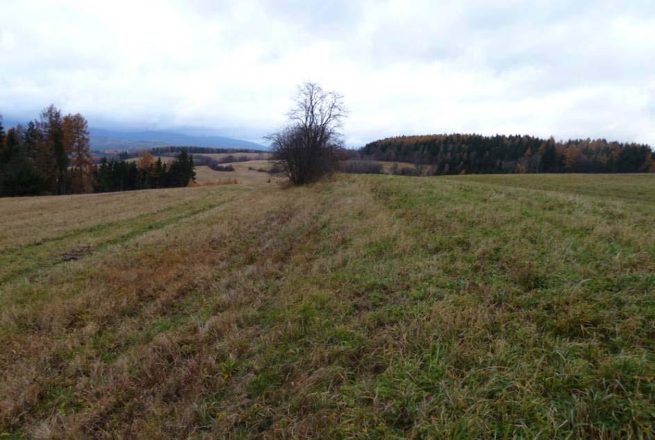
3 5 A ; balk / grass strip of land that may include woody vegetation (i.e. trees and bushes) and stone walls; used against water and wind erosion. 6


4 7 8

5 9 10


6 11 Thalweg 12
7 The LF defined by CZ 13 A balk / grass strip of land that may include woody vegetation (i.e. trees and bushes) and stone walls; used against water and wind erosion. B terraces (may include woody vegetation) C grass strip in Thalweg, that may include woody vegetation D group of woody plants with at least 2 woody plants; area under 2000 m2; cannot be part of a forest E tree row with at least 5 woody plants F solitary trees with a projected crown of at least 8 m2; cannot be part of any of the previously defined LF Vegetated With texture Vegetated Non- textured Image F D E DTM/ Hydrologic B A C Agricultural Lands Financial consequences might be needing a dual agri/non-agri classification. The LF are based upon ecological definitions which are part of a landscape scenario. Ecological/biological ontology might become necessary for management decisions in Landscape Change (Scenario) 14 First some field observations of the Landscape Features Landscape Features are difficult to differentiate in an automatic system A dual system might be a solution (AGRI/NON-AGRI) Confusion matrices can be confusing themselves, 3 different approaches will be shown


8 15 16 Not connected to a line feature


9 17 18

10 19 First some field observations of the Landscape Features Landscape Features are difficult to differentiate in an automatic system A dual system might be a solution (AGRI/NON-AGRI) Confusion matrices can be confusing themselves, 3 different approaches will be shown Scenario and driving agents Ha total LPIS area 4.34 Ha only in digitalization Ha digitized Landscape Features 7.99 Ha in overlap Ha only detected with automatic detection
11 21 The 2% Map of Landscape Features Digitized on screen 22 According to automatic analysis, this map shows that Ha out of Ha is fit for agricultural production. On less than 5% of the area, restrictions on agricultural production might be expected due to available Landscape Features. According to visual interpretation this is less than 2%

12 Ha Ha LPIS 90 Ha LF digitized 154 Ha LF Automatic If trees cast contrasting shadows on agricultural land they will appear in this map. How usefully is this dual information agri/non-agri and at what price level? 30 cent/km²? 24 First some field observations of the Landscape Features Landscape Features are difficult to differentiate in an automatic system A dual system might be a solution (AGRI/NON-AGRI) Confusion matrices can be confusing themselves, 3 different approaches will be shown Scenario and driving agents

13 25 37 Parcels 4 Parcels completely planted with trees. 3 parcels partly planted 26 Oversimplified Confusion Matrix Field Observations Automatic Agriculture Non-Agriculture Agriculture 33 Non- Agriculture 4
14 Automatic Analysis Field Observations & Visual interpretation Textured and contrasting vegetation Non-Textured Vegetation (Agriculture) 27 Textured and contrasting vegetation 1288 polygons ±25 Ha < 5% <25 Polygons <2.5 Ha Non-Textured Vegetation (Agriculture) <20 polygons 0.1 Ha?? 509 Ha Textured and contrasting vegetation Non-Textured Vegetation (Agriculture) Automatic Analysis Field Observations & Visual interpretation Textured and contrasting vegetation 1288 Polygons ±25 Ha <20 polygons 0.01 Ha?? Non-Textured Vegetation (Agriculture) <25 Polygons <0.25 Ha 509 Ha Always 95% or larger 28
15 29 Field Observations A B C D E F A B Automatic Analysis C D E F 30 First some field observations of the Landscape Features Landscape Features are difficult to differentiate in an automatic system A dual system might be a solution (AGRI/NON-AGRI) Confusion matrices can be confusing themselves, 3 different approaches will be shown Scenario and driving agents.


16 31 Does a Biophysical property influences the payment? Row of Trees E Group of trees D Single tree F Can be part of a deteriorating or senility process. The categories can be observations inside an ongoing process 32 Senility


17 33 Degradation ; Young plants with active cattle pressure or..? 34 Succession?


18 35 Pressure Agents and Landscape Mmanagement on LF 36


19 37 Trees you don t miss 38 Trees you might miss


20 Meter Succession of Betula 40

21 41 42


22 43 LF reconstruction? 44


23 45 46


24 47 48
 A GIS layer has a role in decision support.")
25 49 50 Concluding remarks A basic dual classification AGRI / NON-AGRI is possible. NON-AGRI is difficult to diversify. Diversification can be done according to ecological scenario s and pressure on the system (succession, deterioration, senility) A GIS layer has a role in decision support. If the decision is Pay or not-pay, a dual classification would be useful. If biophysical properties of Landscape features are playing a role in the payment, more classification parameters (Features) must become available (DTM/DSM) The bio/physical parameters might be needed in case of management actions like Landscape Feature re-constructions, an expensive measure, which incidentally takes place in the region.
26 51 Acknowledgment to: Ing. G. Tobolka & Ing. J. Bukovsky Central admin. Dept. of registers, ministry of agriculture of the Czech Republic For their Data support and Fieldtrip preparations.
DEFINITION, SPECIFICATION AND GIS LAYER CREATION OF LANDSCAPE FEATURES IN SLOVAKIA INCLUDING POSSIBLE SAPS CONSEQUENCES
 DEFINITION, SPECIFICATION AND GIS LAYER CREATION OF LANDSCAPE FEATURES IN SLOVAKIA INCLUDING POSSIBLE SAPS CONSEQUENCES Michal Sviček ek,, Kristína Gasiorková,, Martin Granec Soil Science and Conservation
GAEC synthesis from CwRS 2010 survey
 1 GAEC synthesis from Cw 2010 survey Vincenzo ANGILERI MarS Unit, IPSC, JRC Ispra Aim of the presentation 2 New GAEC framework applicable since 2010 (except buffer strips) Are minimum requirements for
Semi-automated extraction of Landscape Features from VHR satellite data
 Semi-automated extraction of Landscape Features from VHR satellite data Lukas Brodsky, Katerina Jupova, Lubos Kucera GISAT www.gisat.cz lukas.brodsky@gisat.cz Goals and motivations Landscape Features:
2017 CTS and other technical guidance updates
 The European Commission s science and knowledge service Joint Research Centre 2017 CTS and other technical guidance updates 2017 IACS workshop 29-31 May 2017 Ghent - Belgium Philippe LOUDJANI DG JRC D5
User Awareness & Training: Use of Copernicus data for land monitoring and environmental reporting in Italy Lisbon, Portugal 14 th February 2014 ISPRA
 User Awareness & Training: Use of Copernicus data for land monitoring and environmental reporting in Italy Lisbon, Portugal 14 th February 2014 ISPRA Contents Introduction to land take, urban sprawl and
LANDSCAPE HETEROGENEITY AS A TOOL FOR ENHANCING BIODIVERSITY
 Landscape and Landscape ecology / 17th International Symposium 27 29 May, 2015. Nitra, Slovakia University of Ljubljana, Biotechnical faculty, Agricultural institute of Slovenia, Aquarius d.o.o. LANDSCAPE
PARKS MEMORIALS AND DONATIONS POLICY
 PARKS MEMORIALS AND DONATIONS POLICY Purpose: The purpose of this policy is to establish guidelines, standards and procedures for the installation and care of donated park improvements, either as a result
Nebraska Soil Science Curriculum
 Nebraska Soil Science Curriculum Soil ph: What affects it, what it affects, managing it and testing it Approximately 135 minutes ***Content and lab derived from the USDA-NRCS Guides for Educators. Please
LIVING THROUGH THE LANDSCAPE
 LIVING THROUGH THE LANDSCAPE HEALTY LANDSCAPE NEED COMMON SENSE 19 TH COUNCIL OF EUROPE MEETING OF THE WORKSHOPS FOR THE IMPLEMENTATION OF THE EUROPEAN LANDSCAPE CONVENTION Ing. Svatava Maradová, MBA State
Dr.- Ing. Andreas Hendricks Land consolidation and land development more than reorganizing land property
 Dr.- Ing. Andreas Hendricks Land consolidation and land development more than reorganizing land property Tartu, May 2015 Structure Structural data Objectives Procedures Main stages and features Costs and
City of Surrey Ecosystem Management Study. Integration of ecological processes with land use
 City of Surrey Ecosystem Management Study Integration of ecological processes with land use Natural areas in Surrey are changing as the City grows and evolves. Many important natural areas remain or may
LANDSCAPE INFOGRAPHIC DESIGN. Markéta Krejčí, PhD Iva Hradilová Mendel University of Brno, Czech Republic
 LANDSCAPE INFOGRAPHIC DESIGN Markéta Krejčí, PhD Iva Hradilová Mendel University of Brno, Czech Republic Abstract This lack of understanding is caused by the urban environment complexity as cities and
Annex F FBIS-C Tier 1 Tranche 1 Fencing Specification and installation guidelines
 Annex F FBIS-C Tier 1 Tranche 1 Fencing Specification and installation guidelines Minimum expenditure on all fencing types in FBIS - C The minimum expenditure on each eligible fencing item is 2500, within
BC Soil Information Finder Tool. Questions
 BC Soil Information Finder Tool Questions 1 What is the Soil Information Finder Tool?... 2 2 How accurate is the information for a point on the map?... 3 3 What does Soil Erosion Potential mean?... 4 4
Inherent Factors Affecting Soil ph. Soil ph Management
 Soil ph is a measure of soil acidity or alkalinity. It is an important indicator of soil health. It affects crop yields, crop suitability, plant nutrient availability, and soil micro-organism activity
Lisbon s Green Plan Actions: Towards a Green City
 Lisbon s Green Plan Actions: Towards a Green City Abstract of the presentation on Cost Action 1201 "Urban Allotment Gardens in European Cities - Future, Challenges and Lessons Learned" at LNEC 20 th March
URBAN SMS Soil Management Strategy
 URBAN SMS Soil Management Strategy Baseline scenario analysis Modeling future urban sprawl in pilot cities A. Łopatka, G. Siebielec, A. Żurek, M.Głuszynska, H. van Delden & T. Stuczynski December, 2010
The Salt Marsh Advancement Zone Assessment of Connecticut
 The Salt Marsh Advancement Zone Assessment of Connecticut Front cover image: Salt marsh advancement zones in Stratford, CT from the Comprehensive Map Book of Stratford, CT. Table of Contents Introduction...
City of Norfolk Coastal Flood Mitigation Program. March 13, 2013
 City of Norfolk Coastal Flood Mitigation Program March 13, 2013 Topics Brief overview of Norfolk s Coastal Flood Program Data-driven analysis and decision making City-wide vulnerability, project concepts,
The agri-motive safety performance integrity level Or how do you call it?
 TÜV Rheinland InterTraffic GmbH Safety in Transportation 4 The agri-motive safety performance integrity level Or how do you call it? Dipl.-Ing. Sebastian Gräfling, TÜV Rheinland InterTraffic GmbH Contents
Appendix G. Detailed Design
 Appendix G Detailed Design G1: Construction details Construction detail drawings usually include important details and specifications for required project design elements. This section provides information
Identifying and Preventing Dust Fire and Explosion Hazards
 Identifying and Preventing Dust Fire and Explosion Hazards Warren Greenfield International Specialty Products Wayne, New Jersey ABSTRACT This paper discusses how International Specialty Products Inc. addresses
Soil in EEA s Multi-annual work programme (MAWP)
") EIONET NRC SOIL Ispra, ITALY 23 May 2014 Soil in EEA s Multi-annual work programme (MAWP) 2014-2018 Geertrui Louwagie Ecosystems assessment group Natural systems and vulnerability programme 1 EEA Multi-annual
EIONET NRC SOIL Ispra, ITALY 23 May 2014 Soil in EEA s Multi-annual work programme (MAWP) 2014-2018 Geertrui Louwagie Ecosystems assessment group Natural systems and vulnerability programme 1 EEA Multi-annual
S C I E N C E PREVENTION OF SOIL EROSION SELF INSTRUCTIONAL MATERIALS
 Modified In School Off School Approach Modules (MISOSA) Distance Education for Elementary Schools SELF INSTRUCTIONAL MATERIALS S C I E N C E PREVENTION OF SOIL EROSION 4 Department of Education BUREAU
Why the workshop, why the cases?
 Green Infrastructure in Central and Eastern Europe Cases from the Czech Republic, Poland and Romania Kristijan Civic, ECNC and Agnes Zolyomi, Zolyomi, CEEweb Workshop on redesigning the landscape, connecting
ANALYSIS ON EFFECTS OF SEOUL METROPOLITAN SUBWAY STATION BY USING GIS AND RS
 ANALYSIS ON EFFECTS OF SEOUL METROPOLITAN SUBWAY STATION BY USING GIS AND RS I.T. Yang, S.Y. Lee, S.I. Baek & J.H. Park E-Mail :intae@kangwon.ac.kr Lab. Of Surveying & Geospatial Information Department
Inherent Factors Affecting Soil ph. Soil ph Management
 Soil ph is a measure of soil acidity or alkalinity. It is an important indicator of soil health. It affects crop yields, crop suitability, plant nutrient availability, and soil micro-organism activity,
Forum for European Electrical Domestic Safety FEEDS. B. DOME FISUEL
 Forum for European Electrical Domestic Safety FEEDS B. DOME FISUEL Benoit.dome@gmail.com Twitter @FisuelEU Agenda 1. Participants 2. Objectives 3. White Paper 4. Conclusions 1.Participants Consumer Association
City of Surrey Ecosystem Management Study. Integration of ecological processes with land use
 City of Surrey Ecosystem Management Study Integration of ecological processes with land use Natural areas in Surrey are changing as the City grows and evolves. Many important natural areas remain or may
Ecological Sites. Topics of Discussion 2/28/2014. Ecological Site Classification. Ecological Site Key. Ecological Site Descriptions
 Ecological Sites Topics of Discussion Ecological Site Classification Ecological Site Key Ecological Site Descriptions Jon Siddoway Montana NRCS Helping People Help the Land An Ecological Site is defined
SECTION 900 TURF ESTABLISHMENT
 SECTION 900 901.0 DESCRIPTION This section covers the furnishing of all labor, materials, tools, equipment and performances of all work and services necessary or incidental to turf restoration as indicated
HISTORIC LANDMARK COMMISSION STAFF REPORT. Front Yard Terracing PLNHLC South 1200 East Meeting Date: August 7, 2014
 HISTORIC LANDMARK COMMISSION STAFF REPORT Front Yard Terracing PLNHLC2014-00362 259 South 1200 East Meeting Date: August 7, 2014 Planning Division Department of Community and Economic Development Applicant:
Recycle Florida Today. FDOT Use Of Compost Today And Future
 Recycle Florida Today FDOT Use Of Compost Today And Future Current Use - Roadside Turf and Landscaping Current Use - Roadside Turf and Landscaping FDOT Approaches Construction Contracts Embedded in road/bridge
Minnesota Department of Natural Resource - Natural Resource Guidance Checklist Conserving Natural Resources through Density Bonuses
 Minnesota Department of Natural Resource - Natural Resource Guidance Checklist Conserving Natural Resources through Density Bonuses NRDB Why Use Density Bonuses & This Checklist Local units of government
BC Soil Information Finder Tool
 BC Soil Information Finder Tool This project is a collaborative effort between the British Columbia (BC) Ministry of Agriculture (AGRI) and the BC Ministry of Environment (MoE) with funding from Growing
10/23/18. Science informed regional planning: opportunities for better outcomes. Seeking Better Outcomes for Our Regions
 SEGRA 2018: Beyond the Boom: opportunities for growth and vitality Acknowledge the Traditional Owners of the country where we are meeting today Science informed regional planning: opportunities for better
SECTION PLANTING SOIL for SOIL CELLS. This specification defines material and performance requirements for soils which are to be used
 This specification defines material and performance requirements for soils which are to be used within the Silva Cell system. The SPECIFICATION EDITOR must select the type of soil appropriate to each particular
IAEA SAFETY STANDARDS
 SAFETY STANDARDS FOR DESIGN AND SAFETY ASSESSMENT Oct 2011 Peter Hughes Head of Safety Assessment Section Division of Nuclear Installation Safety International Atomic Energy Agency Contents Safety Standards
Welcome to the EUROPEAN SOIL BUREAU NETWORK 2009 Plenary Meeting. Szent István University, Gödöllő, HUNGARY September, 2009
 Welcome to the EUROPEAN SOIL BUREAU NETWORK 2009 Plenary Meeting Szent István University, Gödöllő, HUNGARY 14-15 September, 2009 Benchmark soils Introduction to the topic Current EU Needs /Expectations
Lecture: Landscape Ecology
 Borderland: Border Landscapes Across Europe 2013 Lecture: Landscape Ecology Dr Iwona Markuszewska Department of Landscape Ecology iwmark@amu.edu.pl Presentation schedule: Landscape ecology as a scientific
Surface Coal Mining and Reclamation in ND. Guy Welch ND Public Service Commission
 Surface Coal Mining and Reclamation in ND Guy Welch ND Public Service Commission Surface Coal Mines in North Dakota Approximately 1500 acres are disturbed each year History of Reclamation in ND First surface
Monitoring Weed Growth in Forest Stands using QuickBird Imagery
 Monitoring Weed Growth in Forest Stands using QuickBird Imagery Mark Norris-Rogers; Fethi Ahmed*; Pol Coppin**; Jan van Aardt** (*University of KwaZulu-Natal; **Katholiek Universiteit Leuven) Outline Introduction
5. Initiating a restoration project
 5. Initiating a restoration project CONTRIBUTING TO CONSERVATION In many parts of the country, restoration planting is your last and only option for repairing or rebuilding damaged native communities so
2.1 Decision Making Matrix
 2.1 Decision Making Matrix The following decision-making matrix merges the elements of architectural and historical significance and current condition within the over-arching treatment recommendation of
Smart Heating Technology Ltd. U Statku 653/24, Ostrava-Bartovice Czech Republic
 Smart Heating Technology Ltd. U Statku 653/24, 717 00 Ostrava-Bartovice Czech Republic AUTOMATIC BIOMASS BOILERS Smart 150 500 1500 kw SMART INDUSTRIAL PARK Ostrava-Bartovice 18 000 m 2 Automatic Boilers
Monitoring and evaluation of the restoration of a highly
 Monitoring and evaluation of the restoration of a highly degraded remnant of the endangered ecological community Eastern Suburbs Banksia Scrub: Potential lessons for how monitoring can guide a restoration
Community LID Workgroup Issue Paper #6
 Community LID Workgroup Issue Paper #6 Topic: Hard and Impervious Surface Coverage Limits Objective: Minimize the amount of hard and impervious surfaces in developments to allow more stormwater to infiltrate
Electronic Newsletter of CEEweb. Spring Issue
 Electronic Newsletter of CEEweb Spring Issue - 2012 IN THIS ISSUE: Editorial EU POLICY ISSUES Negotiations gear up in international biodiversity financing No Net Loss Connecting the Green Dots in the Visegrad
Outflow to Saw Mill Run
 Dormont Stormwater Fee Frequently Asked Questions What is stormwater, and why is it a problem in Dormont? Stormwater is runoff from rain or snow that falls and flows to Little Saw Mill Run or McNeilly
CITY OF VANCOUVER ADMINISTRATIVE REPORT
 CITY OF VANCOUVER ADMINISTRATIVE REPORT Date: October 20, 2004 Author: David Desrochers Phone No.: 604.873.7893 RTS No.: 4716 CC File No.: 5802 Meeting Date: December 14, 2004 TO: FROM: SUBJECT: Vancouver
The Disneyland Resort Specific Plan Section 5.0: Design Plan
 Page 5-159 Page 5-160 Page 5-161 Page 5-162 Page 5-163 Page 5-164 Page 5-165 Page 5-166 Page 5-167 Page 5-168 Page 5-169 Page 5-170 Page 5-171 Page 5-172 Page 5-173 Page 5-174 Page 5-175 5.8.3 District
Soil Properties That Distinguish Ecological Sites
 Soil Properties That Distinguish Ecological Sites Mike Duniway USGS-Southwest Biological Science Center Canyonlands Research Station Moab, UT mduniway@usgs.gov Spokane, WA January 31, 2012 Ecological Sites
Problem soils & its management. Satira Udomsri, LDD
 Problem soils & its management Satira Udomsri, LDD Kingdom of Thailand Location: Southeast Asian mainland 5 o -20 o N 97 o -105 o E Area total: land: water: Capital: 513,120 sq km 510,890 sq km 2,230 sq
IOWA FFA STATE SOILS CDE SATURDAY, OCTOBER 13, 2007 AMES, IOWA
 IOWA FFA STATE SOILS CDE SATURDAY, OCTOBER 13, 2007 AMES, IOWA 1. Moderately sloping has what percent slope: a. 9-14% b. 2-5% c. 5-9% d. over 14% 2. Which of the following horizons is the loose underlying
SEABANK 3. Interim Landscape and Design Statement
 SEABANK 3 Interim Landscape and Design Statement Prepared for: SSE plc URS Infrastructure & Environment UK Limited. Scott House Alencon Link Basingstoke Hampshire RG21 7PP UK 1 TABLE OF CONTENTS 1 INTRODUCTION...
Surrey Ecosystem Management Study
 Surrey Ecosystem Management Study Green Infrastructure Network Opportunities Public Open House & Information Session June 24 th, 2010 EMS Process Ecological Inventory Ecological Assessment Management Policy
The Turtle Creek Master Plan- A Summary. July 7, 2011
 The Turtle Creek Master Plan- A Summary July 7, 2011 Background During 2004, TCA commissioned highly regarded Antonio Di Mambro & Associates to create a Master Plan for the Turtle Creek Corridor. The resulting
Ecosystem services assessment in complex agricultural landscapes using farmers perception
 Ecosystem services assessment in complex agricultural landscapes using farmers perception DelphineBirman, Marc Moraine, Pablo Tittonell, Pierre Martin et Pascal Clouvel Actual challenge of agricultures
A Study on Smart City Development Project for Regional Innovation: Co-creation and Design Thinking Approach
 , pp.48-52 http://dx.doi.org/10.14257/astl.2016.141.10 A Study on Smart City Development Project for Regional Innovation: Co-creation and Design Thinking Approach Taihun Lee 1, * Soon-Goo Hong 1,and Hayeong
UBC Social, Ecological Economic Development Studies (SEEDS) Student Reports
 Student Reports") SEEDS Student Reports 1 UBC Social, Ecological Economic Development Studies (SEEDS) Student Reports University Neighbourhood Association Open House Assessment Rebecca Colter Ivy Chen Nicholas Sinkewicz
SEEDS Student Reports 1 UBC Social, Ecological Economic Development Studies (SEEDS) Student Reports University Neighbourhood Association Open House Assessment Rebecca Colter Ivy Chen Nicholas Sinkewicz
Balance (sustainable) land use and management of protected areas in Lithuania
 land use and management of protected areas in Lithuania") Balance (sustainable) land use and management of protected areas in Lithuania Kastytis Gedminas State Service for Protected Areas under the Ministry of Environment of Lithuania Living Lakes. Eastern Europe
Balance (sustainable) land use and management of protected areas in Lithuania Kastytis Gedminas State Service for Protected Areas under the Ministry of Environment of Lithuania Living Lakes. Eastern Europe
This section covers the planting of seed, sod, trees and vegetation.
 Tender 1, 2017 Page 1 of 5 1. INTENT This section covers the planting of seed, sod, trees and vegetation. 1.1 REFERENCES Agriculture and Agri-Food Canada; The Canadian System of Soil Classification, Third
Actors, scales and modes of heritage representation:
 Actors, scales and modes of heritage representation: lessons from the critical mapping Jaroslav Ira Charles University, Prague jaroslav.ira@ff.cuni.cz Critical mapping of heritage representions Desk-top
THE SPATIAL PLAN AND THE LANDSCAPE IN CZECH REPUBLIC
 THE SPATIAL PLAN AND THE LANDSCAPE IN CZECH REPUBLIC 13th ELC Conference, 2 3 October, Cetnjie, Montenegro Ing. Igor Kyselka CSc., Institute for spatial development, Jakubské náměstí 3, 60200 Brno, tel.:
 108 40' 29'' W Soil Map Mesa County Area, Colorado 108 36' 55'' W 39 10' 11'' N 39 6' 31'' N 4331700 4332500 4333300 4334100 4334900 4335700 4336500 4337300 4338100 701100 701900 702700 703500 704300 705100
FirstLight Power Shoreline Management Manual Sustainable Shoreline Designs: From Long Island to Lake Erie Webinar Series
 FirstLight Power Shoreline Management Manual Sustainable Shoreline Designs: From Long Island to Lake Erie Webinar Series Presented by Jason Williams, PLA, NCI February 19, 2017 Introduction Lakes (impoundments)
2.6 Pawtucket. Pawtucket Impervious Cover Map (61.4% Impervious)
") 2.6 Pawtucket Pawtucket Impervious Cover Map (61.4% Impervious) The City of Pawtucket is approximately 8.7 square miles and is heavily residential with some commercial and industrial land. Table 2.14 below
2.6 Pawtucket Pawtucket Impervious Cover Map (61.4% Impervious) The City of Pawtucket is approximately 8.7 square miles and is heavily residential with some commercial and industrial land. Table 2.14 below
Des Plaines River Watershed: Opportunity Areas North Community Cluster 1:80,000. Miles. Public Parks or Preserve. Wetland Area
 Service Layer Credits: Harris Corp, Earthstar Geographics LLC Earthstar Geographics SIO 2015 Microsoft Corporation Des Plaines River Watershed: Opportunity Areas North Community Cluster SFR: Single Family
A Network Theory Framework for Urban Cultural Heritage Conservation. Manal Ginzarly LEMA, Université de Liège
 A Network Theory Framework for Urban Cultural Heritage Conservation Manal Ginzarly LEMA, Université de Liège Objective Develop an ecological approach to the integration of heritage conservation and urban
STATE TAX COMMISSION OF MISSOURI ASSESSOR MANUAL
 STATE TAX COMMISSION OF MISSOURI ASSESSOR MANUAL CHAPTER: REVISION DATE: 10/1/2008 Page 1 of 18 7.3 The purpose of this section of the Assessor s Manual is to supplement the State Tax Commission s published
Annex D: Project Logframe Matrix
 Annex D: Project Logframe Matrix OVERALL OBJECTIVE: Protect the unique ecosystems and biodiversity along the Sava River through supporting Croatia and Bosnia-Herzegovina in a) improving transborder cooperation
Detection of small landscape elements in Flanders based on remote sensing techniques
 Detection of small landscape elements in Flanders based on remote sensing techniques Jo Van Valckenborgh IACS workshop Ghent, & DEPARTEMENT LANDBOUW & VISSERIJ www.vlaanderen.be/informatievlaanderen Agenda
S9. Thin Dark Surface
 Dominant Field Indicators of Hydric Soils in Florida S9. Thin Dark Surface For use in LRRs R, S, U, and T; for testing in LRRs K and L. A layer 5 cm (2 inches) or more thick within the upper 15 cm (6 inches)
Huntington Stormwater Utility
 Huntington Stormwater Utility Stormwater Management & Sediment and Erosion Control Requirements for Construction Sites Authorized by Huntington City Code Articles: 971, 970, 930, 935, 955, Revised April
ANALYSIS AND EVALUATION OF NATURE SPACE POTENTIAL IN PERI-URBAN SPACES USING REMOTE SENSING DATA AND GIS
 ANALYSIS AND EVALUATION OF NATURE SPACE POTENTIAL IN PERI-URBAN SPACES USING REMOTE SENSING DATA AND GIS Ellen BANZHAF UFZ-Centre for Environmental Research Leipzig-Halle, Permoserstr. 15, D-04318 Leipzig
Supplier Handbook. InSinkErator st Street Racine, WI
 Supplier Handbook InSinkErator 4700 21st Street Racine, WI 53406 262-554-5432 Table of Contents SECTION 1: Introduction... 2 1.1 InSinkErator... 2 1.2 InSinkErator Expectations for a Suppliers Quality
Submitted to Northern Coalfields Limited. Singrauli Coalfield 2015
 Land Restoration / Reclamation Monitoring of more than 5 million cu. m (Coal+OB) Capacity Open Cast Coal Mines of Northern Coalfields Limited based on Satellite Data for the Year 2015 Singrauli Coalfield
Chapter 15 Soil Resources
 Chapter 15 Soil Resources Overview of Chapter 15 What is Soil? Soil Horizons Nutrient Cycling Soil Properties and Major Soil Types Soil Problems Soil Conservation and Regeneration Soil Uppermost layer
Sustainable Design of Alpine Infrastructures
 105 Sustainable Design of Alpine Infrastructures Kathrin ASTE 1 and Frank LUDIN 2 1 LAAC Architects, Innsbruck/Austria kathrin.aste@laac.eu 2 LAAC Architects, Innsbruck/Austria office@laac.eu Abstract
On the way to HARMONY. Ewa Kaczmarczyk
 On the way to HARMONY Ewa Kaczmarczyk 1 The structure of Poland The transport network Road s influence on a landscape Recent political changes in Poland What was done in previous years The SWOT analyses
My name is Zack Holden, co-instructor for this course. Many people associate severe fire with catastrophic, stand-destroying forest fires.
 My name is Zack Holden, co-instructor for this course. Many people associate severe fire with catastrophic, stand-destroying forest fires. But fire can have profound effects on soils and the below ground
Iowa FFA Soil Career Development Event 2008
 Iowa FFA Soil Career Development Event 2008 1. In Iowa, corn suitability ratings for soil mapping units specifies a. natural weather conditions b. surface and subsurface drainage installed where needed
Energy crops and the historic environment
 Energy crops and the historic environment Stephen Trow Head of Countryside Policy, English Heritage English Heritage English Heritage is the Government s adviser on the historic environment, with a statutory
Environmental offsetting for farmland conservation. Arne Grønlund Bioforsk jord og miljø
 Environmental offsetting for farmland conservation Arne Grønlund Bioforsk jord og miljø Farmland in Norway Arable land Cultivated to normal ploughing depth (20-25 cm) and suitable for cultivation of arable
Landscape Ecology and Amphibians
 and Amphibians WFS 533 Wyn Miller March 26, 2009 Overview Introduction to landscape ecology Metapopulation dynamics Natural habitat fragmentation Anthropogenic habitat fragmentation landscape ecology Introduction
Location. Need GOAL 14 URBAN GROWTH BOUNDARY. Urban Planning in Oregon 7/8/2015
 Urban Planning in Oregon June 24, 2015 Redmond, Oregon Gordon Howard, DLCD Urban Planning Specialist GOAL 14 URBAN GROWTH BOUNDARY To provide for an orderly and efficient transition from rural to urban
EXPANDED ENVIRONMENTAL ASSESSMENT FORM PART III Bear Mountain Triangle Rezoning
 EXPANDED ENVIRONMENTAL ASSESSMENT FORM PART III Bear Mountain Triangle Rezoning Town of Yorktown, NY Introduction The Environmental Assessment Form (EAF) examines the environmental implications of the
WQ-07 INFILTRATION TRENCH
 Greenville County Technical Specification for: WQ-07 INFILTRATION TRENCH 1.0 Infiltration Trench 1.1 Description Infiltration Trenches are excavations filled with stone to create an underground reservoir
Low Impact Development and Green Infrastructure 101. The new paradigm for stormwater management
 Low Impact Development and Green Infrastructure 101 The new paradigm for stormwater management Wayne Petersen Urban Conservationist 515-281-5833 Wayne.Petersen@iowaagriculture.gov IDALS s Urban Conservation
CONNECTICUT ENVIROTHON 2012 SOILS QUESTIONS
 CONNECTICUT ENVIROTHON 2012 SOILS QUESTIONS Please select the best response to the following questions. There are 25 4 point questions. Many have more than one part. Good luck! Section 1: Judging the soil
THE LANDSCAPE ECOLOGICAL ASSESSMENT MODEL AND ITS APPLICATIONS
 The 5 th International Conference of the International Forum on Urbanism (IFoU) 2011 National University of Singapore, Department of Architecture Global Visions: Risks and Opportunities for the Urban Planet
Planning Justification Brief
 Planning Justification Brief Proposed Re-Zoning Halton Catholic District School Board 302, 312, 324, 332 Rebecca Street Lots 4, 5, 6, & 7 and Blocks A & B Registered Plan 552 May 2017 Introduction Strategy
Lecture 8 OPENINGS &ORGANIZATION OF FORM AND SPACE
 Islamic University-Gaza Faculty of Engineering Architecture Department Principles of Architectural and Environmental Design EARC 2417 Lecture 8 OPENINGS &ORGANIZATION OF FORM AND SPACE Instructor: Dr.
Using Soil Attributes for HGM Wetland Classification
 Using Soil Attributes for HGM Wetland Classification Richard Weber Wetland Hydraulic Engineer Wetland Team (Ret.) CNTSC, Fort Worth, TX Slide 1 Data Sources: Web Soil Survey County Scale Smaller than Reference
Town of Vershire Road Erosion Inventory Report
 Town of Vershire Road Erosion Inventory Report Taylor Valley Road. Photo taken by TRORC staff. Prepared by: 128 King Farm Road Woodstock, VT 05091 Inventory and report funded by the Vermont Agency of Transportation
Topoclimate Southland Soil Technical Data Sheet No. 76. Mossburn
 This Technical Data Sheet describes the typical average properties of the specified soil. It is essentially a summary of information obtained from one or more profiles of this soil that were examined and
Floriculture and Greenhouse Management
 PRECISION EXAMS Floriculture and Greenhouse Management EXAM INFORMATION Items 56 Points 71 Prerequisites NONE Grade Level 9-12 Course Length ONE YEAR DESCRIPTION Floriculture and Greenhouse Management
Methods to Simulate the Impact of BMPs
 LA221 Project Ortega Watershed Demonstration Area, Quito Ecuador Ricardo da Cruz e Sousa Master of Landscape Architecture & Environmental Planning University of California, Berkeley December 2011 Ortega
A Process-based Method to Simulate Terraces in SWAT
 西北农林科技大学 Northwest A&F University A Process-based Method to Simulate Terraces in SWAT Hui Shao, Claire Baffaut, Jiang Gao, Keqin Wang and Hujun Shang July 17-19, 2013 Terrace Distribution in China Terraces
HUDSON VALLEY REGIONAL COUNCIL 3 Washington Center, Newburgh NY
 PROJECT AREA: HYDE PARK HUDSON VALLEY REGIONAL COUNCIL 3 Washington Center, Newburgh NY 12550 http://www.hudsonvalleyregionalcouncil Insert aerial site photo with streets labeled GREEN INFRASTRUCTURE CONCEPT