THROUGH THE FOREST OF COLUMNS UNFOLDING URBAN BLINDSPOTS
|
|
|
- April Ramsey
- 6 years ago
- Views:
Transcription

1 THROUGH THE FOREST OF COLUMNS UNFOLDING URBAN BLINDSPOTS Spring semester 2013 DIPLOMA PROJECT & EXHIBITION Location: Bergen, Norway Teachers: Espen Folgerø og Vibeke Jensen


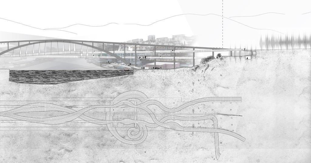
2 BLINDSPOTS CREATED BY INFRASTRUCTURE The theme of this project is blindspots created by infrastructure. There are places in Bergen where vital infrastructural objects like bridges and tunnels generate leftover spaces by cutting through and effectively creating a division in the urban fabric. These blindspots function as psychological and physical barriers and create spatial conflict between the infrastructure and inhabitants. The project focuses on redefining and altering uncanny territory surrounding the imposing structure of a bridge named Puddefjord-bridge, positioned southwestren of the city centre of Bergen. The bridge serves its purpose well as part of the Bergen transportation infrastructure, and in fact plays a vital role in connecting the south- western and north-eastern parts of Bergen. It stretches across a strait called Damsga rdssundet, 30m above the water surface, connecting the old industrial neighborhood Møhlenpris on the city centre side to Gyldenpris and Lakseva g on the other. The structure dwarfs its immediate urban surroundings and creates blindspots near and under its own structure, separating the areas west and east of the bridge on both banks as well as disconnecting human inhabitants from the waterfront. Infrastructural blindspots in Norway Bergen region Infrastructural blindspots Connector MAPS & DRAWINGS OF URBAN BLINDSPOTS Seperator

3 19 UNREACHABLE SPATIAL EXPERIENCE & HIDDEN TREASURES

4 MØHLENPRIS N GYLDENPRIS THE NEW BICYCLE AND PEDESTRIAN PATHS SLITHERING THROUGH THE FOREST OF COLUMNS CREATING A STRONGER CONNECTION
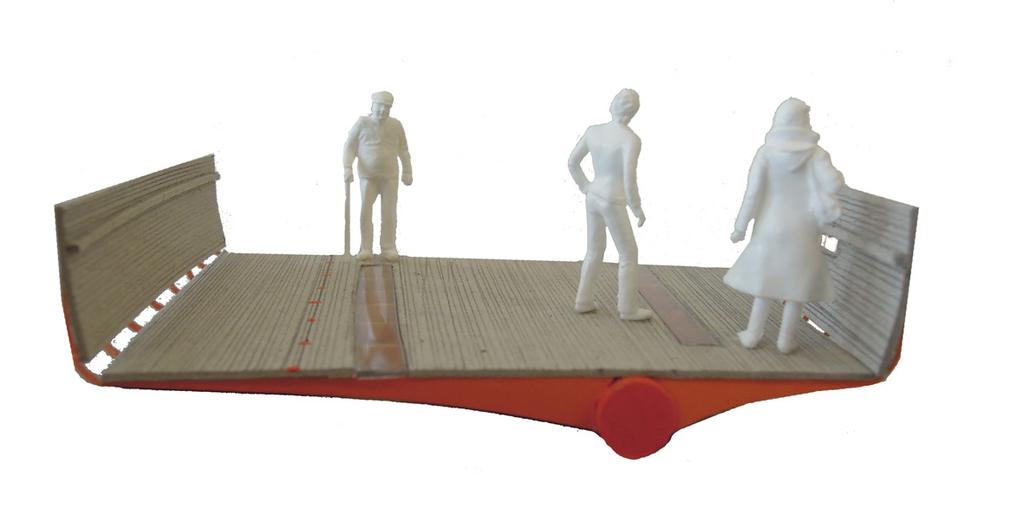
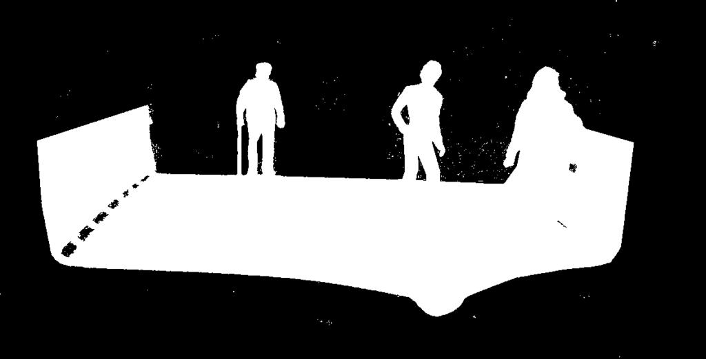
5 NEW INTERCONNECTION The aim of the architectural response is to intersect the existing bridge structure with a web of pedestrian paths to facilitate interconnections between neighborhoods; and to introduce new rhythms to the urban fabric while maintaining a symbiotic relationship between the bridge structure and the architectural response. Instead of participating in the process of further speeding up the experience of the world, the project s intent is to slow down experience, halt time and to defend the natural slowness and diversity of experience. The new bicycle and pedestrian paths slither through the forest of columns under the massive Puddefjord-bridge, separating pedestrians from the noisy traffic on top of the bridge, which provides shelter from rain, snow and pollution with its decking. The paths limbs stretch into the neighborhoods in an inviting gesture, drawing people into this unknown and hidden territory of infrastructural blindspots, revealing and shedding light on a sequence of hidden treasures along the way with the aim of creating multi-sensory experiences for those that move along them. 21


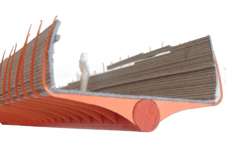
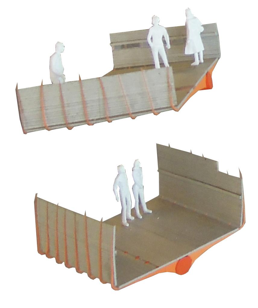
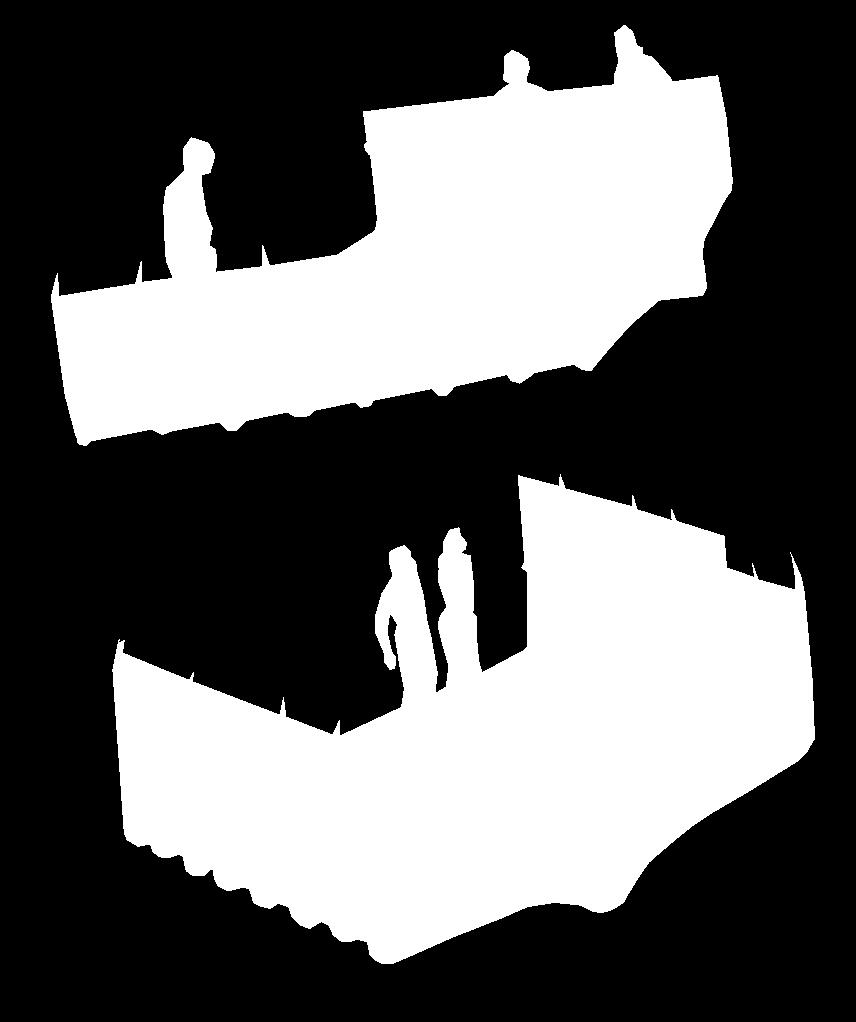
6 The new construction is merged into the rough concrete structure of the existing bridge like an endosymbiont an organism living with another organism connecting the human scale to the infrastructural scale. The steel spine of the construction connects to the existing columns and thin steel ribs stick out of the spine forming support for the floor of the path while also bending up to support a handrail and in some places walls of shelter. The floor is composed of wooden planks that extend upwards along the edges to form a handrail, providing people with a soft and warm feeling of touch when holding it. In some places along the path the materials used in the handrail and floor differ, as a sign of warning and to get people to slow down, hear and feel the different spatial qualities the construction provides and the area has to offer. The paths also lead to areas that are currently unaccessible, especially close to the water. This revitalizes them as a part of the cultural landscape leading to new kind of activities taking place there. MØHLENPRIS

7 GYLDENPRIS 23


8 THE EXHIBITION DETAIL MODELS IN THE SCALES; 1:20, 1:50 AND 1:100, SHOWING THE CONCEPT DEVELOPMENT, THE BRIDGE STRUCTURE AND DETAILS IN DIFFERENT LOCATIONS ALONG THE PEDESTRIAN PATH. THE MAIN MODEL OF THE SITE AND THE RESEARCH PART OF THE PROJECT IN THE BACK


9 DETAIL MODELS IN THE SCALE 1:1, 1:20, 1:50 AND 1:100, SHOWING THE BRIDGE STRUCTURE AND DETAILS IN DIFFERENT LOCATIONS ALONG THE PEDESTRIAN PATH. THE MAIN MODEL OF THE SITE AND DRAWINGS IN THE BACK THE ARCHITECTURAL RESPONSE: THE MAIN MODEL IN THE SCALE 1:200, SHOWING THE PEDESTRIAN PATH SLITHERING THROUGH THE FOREST OF COLUMNS UNDERNEATH THE EXISTING BRIDGE; DRAWINGS IN THE SCALES 1:1000 AND 1:200 ALONG WITH PHOTOS AND DIAGRAMS SHOWING HOW THE PEDESTRIAN BRIDGE CREATES CONNECTIONS BETWEEN NEIGHBORHOODS IN THE AREA 25
THE EAMES HOUSE. c a s e s t u d y h o u s e # 8. Patricia Villafane
 THE EAMES HOUSE c a s e s t u d y h o u s e # 8 Patricia Villafane ABOUT case study house program + the Eames CASE STUDY PROGRAM FORMAL APPEARANCE SPATIAL QUALITIES HOW ITS MADE Structural + materials
Strategic revitalization of polluted bay area into new citizens park
 2015 Strategic revitalization of polluted bay area into new citizens park The project transforms Töölönlahti, a polluted bay area currently dividing Helsinki s centre in two, into an attractive green heart
Welcome. Community Consultation Meeting November 28, Review and discuss the Bathurst Quay Neighbourhood Plan Framework
 Welcome Community Consultation Meeting November 28, 2016 Why Are We Here Today? Review and discuss the Bathurst Quay Neighbourhood Plan Framework Review and discuss an Action Plan for Implementation Next
Guiding Principles. People dance, and to share culture. Place consistency and internal connections. Management community for years to come
 3. The Campus Concept This chapter presents an overview of the Campus Concept from the formulations of its guiding principals through general recommendations to facilitate the triple urban design plan
(SUB)URBAN LIVINGROOM!
URBAN LIVINGROOM!") COMPETITION PROPOSAL TEAM CODE: (SUB)URBAN LINGROOM! PUBLIC 1/3 PUBLIC TEAM CODE: YARDS FOR EERYONE! PRATE 2/3 PRATE TEAM CODE: LET S MEET AT THE TOWER! 3/3 COMPETITION PROPOSAL (SUB)URBAN LINGROOM! Suvela
COMPETITION PROPOSAL TEAM CODE: (SUB)URBAN LINGROOM! PUBLIC 1/3 PUBLIC TEAM CODE: YARDS FOR EERYONE! PRATE 2/3 PRATE TEAM CODE: LET S MEET AT THE TOWER! 3/3 COMPETITION PROPOSAL (SUB)URBAN LINGROOM! Suvela
ROAD CONSTRUCTION. 36 June 2014 ROADS&BRIDGES
 ROAD CONSTRUCTION 36 June 2014 ROADS&BRIDGES Young is full of life Recent expansion completes continuous, multilane arterial By Donald Hammack, P.E. Contributing Author The Florida Department of Transportation
3. STRATEGY FOR NEIGHBORHOOD SUSTAINABILITY
 3. STRATEGY FOR NEIGHBORHOOD SUSTAINABILITY This neighborhood plan focuses on assuring that Government Hill retains a high degree of sustainability, in that it conserves built resources that are part of
Illustrative Development Plan
 Illustrative Development Plan December 7, 005 045 Sansome St., Studio 3 San Francisco, CA 94 Area A - Increase visibility to waterfront and aquatic center from the Embarcadero - Provide streets rather
City of Long Beach. creating vibrant and exciting places
 City of Long Beach creating vibrant and exciting places Land Use Element Urban Design Element Overview of the two draft General Plan elements Discuss areas of change Economic goals of the plans Case study
THE MUNICIPALITY OF OSLO APPLICATION FOR CANDIDACY THE LANDSCAPE AWARD OF THE COUNCIL OF EUROPE
 THE MUNICIPALITY OF OSLO APPLICATION FOR CANDIDACY TO THE LANDSCAPE AWARD OF THE COUNCIL OF EUROPE 2016-2017 THE RIVERS AND LANDSCAPES OF OSLO Oslo's landscape is rich and varied its topography, geology
2. Form and Character. 2.1 Introduction. 2.2 The Downtown Addition Plan. 2.1 Introduction
 2.1 Introduction 2.1 Introduction This section of the Specific Plan describes and illustrates the desired form, character and uses of the Downtown Addition and explains the underlying design principles.
VEHICULAR AND PEDESTRIAN CIRCULATION
 This perspective sketch communicates the intended character and quality of a proposed streetscape design. Locate benches near a major intersection where people tend to gather. Seating and lighting provide
Cities and Situations
 Cities and Situations after 20 years a new Plan for Bologna Twenty years after the last general urban plan, Bologna has commenced the programme for the approval of a new instrument governing the territorial
PROJECT SITE The Proposed Project includes the Allen and Pike Street malls between Delancey and South Streets (see Figure 2C-1).
.") Chapter 2, Section C: A. INTRODUCTION This chapter considers the potential of the proposed Reconstruction of the Allen and Pike Street Malls project to affect the urban design characteristics and visual
Chapter 2, Section C: A. INTRODUCTION This chapter considers the potential of the proposed Reconstruction of the Allen and Pike Street Malls project to affect the urban design characteristics and visual
Making Transit Oriented Development Work For Boonton, NJ
 Making Transit Oriented Development Work For Boonton, NJ Bloustein School of Planning and Public Policy Studio Dan Burton Loannie Dao Webster Slater Brandon Williams Ian Watson Maria Laham Nicola Mammes
Context Integrated Infrastructure Planning. Key to attractive and competitive urban regions. POLIS Conference Urban Mobility in Transition
 18-11-2016 Integrated Infrastructure Planning Key to attractive and competitive urban regions POLIS Conference Urban Mobility in Transition Rotterdam, 1 December 2016 Raymond Linssen, The Netherlands Context
Stockton Waterfront Master Plan. Waterfront Master Plan
 Stockton Waterfront Master Plan Presentation Objectives Process update Planning observations Planning Goals Planning Principles Review of planning activities Summary and next steps Planning Activities
l i v i n g a m i d s t m e a d o w s - m a s t e r p l a n n i e u w v e e n s e l a n d e n
 living amidst meadows - master plan nieuwveense landen l i v i n g a m i d s t m e a d o w s - m a s t e r p l a n n i e u w v e e n s e l a n d e n City of Meppel project manager Ina Eleveld Postbus 501,
BLOK BADEL ZAGREB. Competition for the urban-architectural concept design for the BADEL SITE redevelopment COMPETITION NUMBER: ZG-UA
 BLOK BADEL ZAGREB Competition for the urban-architectural concept design for the BADEL SITE redevelopment COMPETITION NUMBER: 136-12-ZG-UA 1.0 DESCRIPTION AND EXPLANATION OF THE OVERALL CONCEPT The Badel
ISU Department of Architecture. Exchange Program Course Offerings
 IU Department of Architecture Exchange Program Course Offerings emesters: all () - late August through mid- December pring () - mid- January through early May DEIGN TUDIO: All design studios are 6 credit
North Fair Oaks Community Plan Summary and Information
 North Fair Oaks Community Plan Summary and Information WHAT IS THE NORTH FAIR OAKS COMMUNITY PLAN? The North Fair Oaks Community Plan is part of the San Mateo County General Plan, and establishes policies
Environmental Activity Nodes
 Chinese here 环保 Design Eco-Programming and Eco-Programming & Design Environmental Activity Nodes ENVIRONMENTAL EDUCATION WATER CLEANSING +URBAN DESIGN MARKETPLACE FOR LOCAL PRODUCTS Case Studies Xochimilco
Project Location. Jay and Patty Baker Park and Gordon River Greenway Connector Bridge. Naples Beach Golf Club. Gordon River. East. Naples.
 Gordon River Project Location Naples Beach Golf Club East Naples Naples Naples Bay Evergreen Golf and Country Club and Gordon River Greenway Connector Bridge Gordon River Greenway CONNECTOR BRIDGE AND
New Auburn Village Center Study Auburn, Maine
 Auburn, Maine Option Review Summary Prepared for: Androscoggin Transportation Resource Center and City of Auburn Prepared by: T.Y. Lin International MRLD October 10, 2013 1. Introduction This memo summarizes
Climate Change Adaptation Challenges seen from a Norwegian perspective
 Climate Change Adaptation Challenges seen from a Norwegian perspective Tartu, Estonia Tuesday May 19 th 2015 Kjell Harvold, Senior researcher Norwegian institute for Urban and Regional Research Main points
PIKE PINE RENAISSANCE: ACT ONE. October 19, 2017
 PIKE PINE RENAISSANCE: ACT ONE October 19, 2017 WATERFRONT SEATTLE PROGRAM PROJECT INTRODUCTION Pike and Pine streets, between First and Melrose avenues Pedestrian and streetscape improvements Budget:
Outer Congress Street Land Use
 Outer Congress Street Land Use Outer Congress Street, with its historic residential district, natural resource and open space amenities, trail network, and proximity to major transportation infrastructure
TIER ONE - CMI URBAN DESIGN OBJECTIVES
 TIER ONE - CMI URBAN DESIGN OBJECTIVES V I S I O N TO CREATE A MOTORWAY CORRIDOR THAT: makes a positive contribution to city-wide connectivity and the urban fabric of Auckland is visually stimulating and
FUNDAMENTAL BUILDING BLOCKS
 FUNDAMENTAL BUILDING BLOCKS THE WEB OF GIBSONS - EXISTING Lacks Community Structure and Support Circulation, surface water flow and buildings are disjointed from the community Social neighbourhoods are
38 Queen s University Campus Master Plan Part 1
 38 Queen s University Campus Master Plan Part 1 46 The Campus at the City Scale Chapter 4 The Campus at the City Scale 39 Queen s is an urban University centrally located in Kingston. Decisions made by
3 TOWN OF WHITCHURCH-STOUFFVILLE OFFICIAL PLAN AMENDMENT NOS. 116 & 117
 3 TOWN OF WHITCHURCH-STOUFFVILLE OFFICIAL PLAN AMENDMENT NOS. 116 & 117 The Planning and Economic Development Committee recommends the adoption of the recommendations contained in the following report,
Downtown Cleveland Alliance/Tremont
 Cleveland Innerbelt Urban Design Stakeholder Workshops Downtown Cleveland Alliance/Tremont May 4, 2007 2007 Activities: What We re Going To Be Doing. March 8, 2007 Initiate Urban Design Aesthetic Study
THE NEW LISBON CONGRESS CENTRE ARCHITECTURE
 THE NEW LISBON CONGRESS CENTRE PARQUE EDUARDO VII Extended Abstract João Miguel Caramujo Ramos Endrenço Project Report to obtain the Master of Science Degree in ARCHITECTURE Supervisor: Teacher Teresa
LOS ANGELES MISSION COLLEGE MASTER PLAN Master Plan DESIGN & DEVELOPMENT PRINCIPLES
 LOS ANGELES MISSION COLLEGE MASTER PLAN DESIGN & DEVELOPMENT PRINCIPLES 34 Quality Learning Along the Arroyo PROGRAM SUMMARY BY PROJECT The following are program summaries for each of the projects planned
CHAPTER 13 DESIGN GUIDELINES
 CHAPTER 13 DESIGN GUIDELINES Section 1300.00 Section 1300.01 Design Guidelines Purpose The purposes of this section are to: A. The purpose of this Section is to establish procedures and standards to serve
Project introduction and relevance:
 Project introduction and relevance: Every city has a central area or district where, most of the social and commercial activity within the city is concentrated. Norzin Lam is in the process of becoming
CITY OF KEIZER MASTER PLAN APPLICATION & INFORMATION SHEET
 CITY OF KEIZER MASTER PLAN APPLICATION & INFORMATION SHEET PRE-APPLICATION CONFERENCE Prior to the actual filing of a Master Plan application, it is strongly recommended that the applicant contact Planning
WELLINGTON STREET WEST COMMUNITY DESIGN PLAN
 36 3.CDP POLICIES 37 Wellington Street West CDP Vision Statement 38 3.1 Introduction 3.1.1 Purpose The development of buildings and public spaces is influenced by a variety of factors over time. City of
URBAN PROJECT OF THE BENFICA STATION SURROUNDING AREA
 URBAN PROJECT OF THE BENFICA STATION SURROUNDING AREA José Miguel Camilo de Matos Santos Pereira Extended Abstract INTRODUCTION The purpose of this report is to expose the strategies drawn to answer the
Maplewood Avenue Downtown Complete Street Project
 Maplewood Avenue Downtown Complete Street Project Second Public Meeting January 24, 2018 Welcome and Introduction of Project Team City Planning and Public Works Staff City of Portsmouth Juliet Walker Planning
Creating Quality Places: Successful Communities by Design
 Creating Quality Places: Successful Communities by Design Communities across the metropolitan Kansas City area are growing. Our challenge is to shape future development in ways that will maintain and enhance
Creating an integrated waterfront. Recommendations
 Creating an integrated waterfront Recommendations Railway Square Post Office + Shell Station Post Office Square Civic Square Ilot Green Wakefield St Wakefield St (Tory Cars) Wakefield St (New World Supermarket)
10.0 Open Space and Public Realm
 10.0 Open Space and Public Realm 10.0 Open Space and Public Realm The Public Open Space System is comprised of: outdoor spaces available for public use that are either publicly owned (e.g., parks and
EVALUATION OF THE PROPOSED CENTAL BEACH MASTER PLAN BY T H E C E N T R A L B E A C H A L L I A N C E October 2010 INTRODUCTION
 Please read this report which will be presented to the membership for approval at the meeting on November 4, 2010. To read the Master Plan go to www.fortlauderdale.gov/planning_zoning/central_beach_masterplan.htm
Stakeholders Advisory Working Groups (SAWGs) Smart Growth and TOD Land Use (#11) SAWG Meeting
 Smart Growth and TOD Land Use (#11) SAWG Meeting") Presentation - Part II Tappan Zee Bridge/I-287 Corridor Project July 21, 2010 Slide 1. David Kooris (Regional Plan Association) welcomed members of the Land Use Stakeholders Advisory Working Groups (SAWGs)
Presentation - Part II Tappan Zee Bridge/I-287 Corridor Project July 21, 2010 Slide 1. David Kooris (Regional Plan Association) welcomed members of the Land Use Stakeholders Advisory Working Groups (SAWGs)
Town Center Design Guidelines
 Adopted by City Council on September 18, 2018 Design Theme The Draper Town Center Design Theme is defined as encompassing those architectural design styles that were prevalent in the construction of civic
Summary of key themes from ideas competition page 1 of 5. Summary of Key ThemeS: The ViaducTS
 Summary of key themes from ideas competition page 1 of 5 re:connect Ideas COmpeTITION Summary of Key ThemeS: The ViaducTS december 2011 PAGE 2 of 5 RE:CONNECT The submissions and commentary presented in
WELLINGTON HOSPITAL DESIGN GUIDE TABLE OF CONTENTS
 WELLINGTON HOSPITAL DESIGN GUIDE TABLE OF CONTENTS 1.0 Introduction Page 2 The Place of Wellington Hospital 2 The Future of the Hospital 2 2.0 The Intention of the Design Guide 3 3.0 Analysis 4 General
New Orleans East District 9, 10 & 11. St. Martin Brown & Associates
 New Orleans East District 9, 10 & 11 Work with neighborhoods to develop revitalization plans that are rational, thoughtful, can be implemented, and formed into a citywide recovery plan for submission
HISTORIC BRIDGES IN PULASKI COUNTY. Bridges Listed on the National Register of Historic Places in Pulaski County
 Arkansas State Highway and Transportation Department HISTORIC BRIDGES IN PULASKI COUNTY Bridges Listed on the National Register of Historic Places in Pulaski County 2004 Arkansas State Highway and Transportation
Cosmo Innovative Center Republic of Macedonia 5/25/2018 1
 Understanding the livability in a city through smart solutions and urban planning toward developing sustainable livable future of the city of Skopje Emilija Sofeska 1 1 Cosmo Innovative Center Republic
LOCATION AND DESIGN DIVISION
 VIRGINIA DEPARTMENT OF TRANSPORTATION LOCATION AND DESIGN DIVISION INSTRUCTIONAL AND INFORMATIONAL MEMORANDUM GENERAL SUBJECT: Landscape Architecture Program NUMBER: SPECIFIC SUBJECT: Integration of Landscape
DOWNTOWN RESIDENTIAL DISTRICT DEVELOPMENT OPPORTUNITES
 DOWNTOWN RESIDENTIAL DISTRICT DEVELOPMENT OPPORTUNITES Out of all the areas in Downtown Painesville, this district provides the greatest opportunity for change with the vacation of Lake East Hospital.
/05 Architectural Response
 /05 Architectural Response 5.1 Inspiration Stacked Boxes (Artist : Rachael Whiteread) Cubism ( Architect : Le Corbusier) 52 1133 Melville Rezoning Submission Patterns ( Textile Artist : Annie Albers) Overlapping
The River Hub: NEW BUILDINGS
 Summary The River Hub includes 6 municipalities that all boarder the Fraser River. Combined, they are expected to double in population over the next 50 years. To accommodate this new population, 138,831
INNERBELT BRIDGE PUBLIC MEETING #2
 Welcome to the INNERBELT BRIDGE PUBLIC MEETING #2 Today s Discussion Welcome and Introductions (Bob Brown, City of Cleveland) Innerbelt Project Status (Craig Hebebrand, ODOT) Bridge Type Selection Update
Figure 3-1: Public Realm Plan
 3 Public Realm Figure 3-1: Public Realm Plan 3.1 Public Realm Concept The public realm concept for the Little Mountain site integrates a clear and accessible movement network with public spaces for social
Town of Blooming Grove Comprehensive Plan. Public Meeting October 13, 2004
 Town of Blooming Grove Comprehensive Plan Public Meeting October 13, 2004 Overview of Presentation Process Plan Vision Recommendations Next Steps Process: Listening to the Public Monthly meetings with
2. reimagine kings way undercroft as a community space
 2. reimagine kings way undercroft as a community space CLARENDON STREET CLARKE STREET QUEENS BRIDGE STREET MORAY STREET CITY ROAD BALSTON STREET BOYD KINGS WAY POWER STREET KAVANAGH WEST GATE FREEWAY Figure
Proposed Comprehensive Plan Strategies DRAFT for discussion June 28, 2017
 Proposed Comprehensive Plan Strategies DRAFT for discussion June 28, 2017 Land Use Rural Areas Refine the Farm and Forest area (FF) Update FF boundaries to account for existing lots less than five acres
7.5 Impacts on the Section 4(f) Properties
 Properties") constructive use, such as noise, air quality and visual impacts were also assessed. It was determined that this project would not introduce changes of an external nature that would affect the recreational
constructive use, such as noise, air quality and visual impacts were also assessed. It was determined that this project would not introduce changes of an external nature that would affect the recreational
04Design. Methodology. Future of Jacksons Hill Identifying Potential Uses Building Typology and Adaptability Community Engagement
 Jacksons Hill Adaptive Re-Use Study 25 04Design Methodology Objectives Future of Jacksons Hill Identifying Potential Uses Building Typology and Adaptability Community Engagement Jacksons Hill Adaptive
TOWN COUNCIL / PLANNING COMMISSION
 Workshop #3 TOWN COUNCIL / PLANNING COMMISSION January 20, 2011 Consultant Team In Attendance Tonight BMS Design Group Nevada City and San Francisco Michael Smiley, AICP, ASLA Partner-in-Charge Nancy L.
ILLUSTRATIVE MASTERPLAN
 ILLUSTRATIVE MASTERPLAN The Development Dairy Crest (Imperial College) The Proposed Development aims to create a new high quality residential neighbourhood, alongside a new public park for White City.
CHAPTER 8 ISSUES, CONCERNS, CONSTRAINTS AND OPPORTUNITIES
 CHAPTER 8 ISSUES, CONCERNS, CONSTRAINTS AND OPPORTUNITIES Introduction This River Conservation Plan was developed during a time of tremendous activity and effort in planning the transformation of the Delaware
Task Force on Water-land Interface
 Task Force on Water-land Interface For discussion on 2 June 2016 TFWL/02/2016 An Overview of Railing Design along Victoria Harbourfront PURPOSE This paper gives Members an overview of the design of existing
VIEW SHAFTS. Figure 32: Existing view shafts which are to be protected and enhanced and desirable new view shafts ANNEX 2
 VIEW SHAFTS 2.9.1 Sight lines, both from within the Viaduct Harbour area, and into the area from without, are a vital component of the character of the area. They are also an invaluable means by which
The Illinois Department of Transportation and Lake County Division of Transportation. Route 173, including the Millburn Bypass
 The Illinois Department of Transportation and Lake County Division of Transportation welcome you to this Public Hearing for U.S. Route 45 from Illinois Route 132 to Illinois Route 173, including the Millburn
Project Site. Kyle Jacobson
 Project 2.002 - Site Kyle Jacobson The culmination of the semester s analysis in the Marigny concluded with a site proposal for an open space within the neighborhood. The site design focused on the relationship
,,XIX century was the age of empires, XX century the age of states, XXI century becomes the age of cities. Wellington E. Webb, Mayor of Denver
 ,,XIX century was the age of empires, XX century the age of states, XXI century becomes the age of cities Wellington E. Webb, Mayor of Denver 1 VILNIUS : FACTS & FIGURES 16 million inhabitants in a 300
I Street, Sacramento, CA
 REPORT TO PLANNING COMMISSION City of Sacramento 12 915 I Street, Sacramento, CA 95814-2671 To: Members of the Planning Commission PUBLIC HEARING March 10, 2011 Subject: El Dorado Savings Sign Variance
DRAFT ROOSEVELT ROAD. District Recommendations. Figure 5.23 The Roosevelt Road Corridor
 CHAPTER 5 Figure 5.23 The Road Corridor Road will develop as a mixed-use corridor, emphasizing regional retail, west of the river and mixed-use development east of the river. KEY RECOMMENDATIONS 1. High
242 neighborhoods NEIGHBORHOOD 4: JORDAN AVENUE CORRIDOR
 NEIGHBORHOOD 4: JORDAN AVENUE CORRIDOR Aerial View of Jordan Avenue Corridor EXISTING CHARACTER The Jordan Avenue Corridor is the portion of North Jordan Avenue that extends north from East Third Street
Asheville Design Center March 2010
 Community-Based Design Update Asheville Design Center March 2010 www.ashevilledesigncenter.org 1 introduction contents 1. Introduction 2. Background 3. ovember Design Charrette 4. January Work Session
New York Avenue Streetscape and Trail Project Public Meeting #1 Summary
 New York Avenue Streetscape and Trail Project Public Meeting #1 Summary I. King Jordan Student Academic Center (SAC) Gallaudet University, Washington, DC February 23, 2017 Table of Contents 1.0 Introduction...
Downtown Redevelopment Project Update
 Downtown Redevelopment Project Update The redevelopment project will begin the week of September 4, 2017. It is anticipated that construction will be approximately 565 days, depending on weather. 7-6-18
Dogpatch/22nd Street Greening
 TEAM MEMBERS Prepared for: GreenTrustSF Central Waterfront www.gtsfcw.org Prepared by: Fletcher Studio San Francisco, CA www.fletcherstudio.com Landscape Architecture Urban Design Environmental Planning
Concrete bridges design assessments and its relationship with the surrounding space
 Concrete bridges design assessments and its relationship with the surrounding space Abstract: Assist. Prof. Dr. Akram Farouk Ain Shams University Faculty of Engineering Department of Architecture Cairo,
Project Profile BAR HARBOR
 1 BAR HARBOR The Bar Harbor Master Plan merges community vision with design guidelines to preserve the unique character of Bar Harbor Village. PROJECT SUMMARY Overview: The economic vitality of Bar Harbor
Southern Gateway Project and Public Green
 Southern Gateway Project and Public Green Transportation and Trinity River Project Committee May 23, 2016 Purpose of Presentation Provide the history and an overview of the Southern Gateway Project (SGP)
Tonight s Agenda. Summary Presentation Open House. Group Discussion Next Steps: online community wide survey
 Community Open House February 22, 2018 Tonight s Agenda Summary Presentation Open House Station 1: Project Overview and Community Input Station 2: Draft Vision and Guiding Principles Station 3: Western,
Rolla Comprehensive Plan Update, 2005 COMMUNITY ISSUES MEMORANDUM 11/1/2004
 COMMUNITY ISSUES MEMORANDUM 11/1/2004 Introduction Throughout the planning process, but particularly during the early phases of the update, various individuals and groups will be asked to identify and
Urban Conservation Practice Physical Effects ESTABLISHMENT, GROWTH, AND HARVEST NUTRIENT MANAGEMENT
 NOT WELL 800 - Urban Stormwater Wetlands A constructed system of shallow pools that create growing conditions for wetland plants to lessen the impacts of stormwater quality and quantity in urban areas.
ANALYSIS OF PROPOSALS ERIK MØLLER ARKITEKTER KANOZI ARKITEKTER LILJEWALL ARKITEKTER
 ANALYSIS OF PROPOSALS ARKITEKTER ARKITEKTER ARKITEKTER 1 CRITERIA A. CONTINUITY B. EFFICIENCY C. QUALITY D. DIVERSITY E. ACCESSIBILITY How are the connections between adjacent neighborhoods and Region
GUIDELINES EXHIBITION PLACE LOCATION: OBJECTIVES. Structure Plan URBAN DESIGN GUIDELINES
 Development in the Exhibition Place lands will be consistent with the following urban design guidelines. They provide a framework for new development of the lands and are to be read in conjunction with
EXECUTIVE SUMMARY INTRODUCTION. Nicolle Shandrow, Laura Antul, Samee Swartz, Worcester Polytechnic Institute
 EXECUTIVE SUMMARY Nicolle Shandrow, Laura Antul, Samee Swartz, Worcester Polytechnic Institute INTRODUCTION Copenhagen has been struggling with problems related to traffic congestion since the city s expansion
RIGA LATVIA. KEY FEATURES OF THE CITY Demographic Facts. Urban Figures. Heritage. EXISTING GOVERNANCE MECHANISMS Development and Management Plans
 RIGA LATVIA KEY FEATURES OF THE CITY Demographic Facts around 700.000 inhabitants in the city 1.15 million people in the Riga region Urban Figures the medieval core of the Old Town the 19th century grid
Study Area. Capitol Way. Greening America s Capitals 11/13/2014. A Greening America s Capitals Project
 Olympia, WA: Greening Capitol Way Supporting Communities move towards sustainability is a priority for the federal government. A Greening America s Capitals Project Office of Sustainable Communities U.S.
WELCOME NEIGHBORS! April 11, 2019
 District of Columbia Water and Sewer Authority David L. Gadis, CEO and General Manager Clean Rivers Project Northeast Boundary Tunnel Tunnel Forum Meeting WELCOME NEIGHBORS! April 11, 2019 0 Welcome! 1
Draft for Public Review. The Market and Octavia Neighborhood Plan
 Draft for Public Review The Market and Octavia Neighborhood Plan San Francisco Planning Department As Part of the Better Neighborhoods Program December 2002 IOverview Why Plan a Better Neighborhood Here
Task Force on Harbourfront Developments in Kowloon, Tsuen Wan and Kwai Tsing
 Task Force on Harbourfront Developments in Kowloon, Tsuen Wan and Kwai Tsing For discussion on 2 June 2016 TFK/03/2016 AMENDMENTS TO THE APPROVED TSUEN WAN OUTLINE ZONING PLAN NO. S/TW/31 PURPOSE This
Clay Street Bridge Replacement Project
 Clay Street Bridge Replacement Project Frequently Asked Questions (FAQs) No. 2 April 4, 2018 The project is located in downtown Placerville on Clay Street between US Highway 50 and Main Street and Cedar
Kate Luxner. Tulane School of Architecture 14 University of Maryland 08
 Kate Luxner Tulane School of Architecture 14 University of Maryland 08 tanzakademie NEW ORLEANS, LA FALL 2012 CRITIC: WAYNE TROYER The Tanzakademie is intended to provide a center for the study and performance
WATERLOO STATE SIGNIFICANT PRECINCT SUMMARY OF STUDIES
 WATERLOO STATE SIGNIFICANT PRECINCT SUMMARY OF STUDIES Technical studies will be undertaken to inform the master planning process for the Waterloo precinct to develop a Precinct Proposal to redevelop the
OVERVIEW PROJECT SUMMARY
 OVERVIEW Parklets are very small parks or mini-plazas that are constructed in on-street car parks. San Francisco s parklets programme provides inspiration for how we may use parking spaces to drive better
ARCHITECTURE AND PLANNING
 ARCHITECTURE AND PLANNING Subject Code: AR Course Structure Sections/Units Topics Section A Section B Section C Section D Section E Section F Section G Section H Architecture and Design Building Materials,
FRUITVALE TRANSIT VILLAGE (Phase 2) Residential Project
 Residential Project") FRUITVALE TRANSIT VILLAGE (Phase 2) Residential Project DEVELOPER: SIGNATURE PROPERTIES ARCHITECT: HKIT ARCHITECTS April 23, 2010 TABLE OF CONTENTS 3 Vision 4 Description of Site 5 Guiding Concepts 6
FRUITVALE TRANSIT VILLAGE (Phase 2) Residential Project DEVELOPER: SIGNATURE PROPERTIES ARCHITECT: HKIT ARCHITECTS April 23, 2010 TABLE OF CONTENTS 3 Vision 4 Description of Site 5 Guiding Concepts 6
CHAPTER 1. Ms. Guajardo s Class - Central Elementary CH 1 1
 INTRODUCTION CHAPTER 1 Ms. Guajardo s Class - Central Elementary CH 1 1 1.1 SETTING South Centre City is a linear corridor south of Downtown Escondido paralleling Centre City Parkway and South Escondido
SCIENCE FICTION >> WEIRD FACTION MASTER OF LANDSCAPE ARCHITECTURE PROGRAM FALL 2014
 SCIENCE FICTION >> WEIRD FACTION MASTER OF LANDSCAPE ARCHITECTURE PROGRAM FALL 2014 UNIVERSITY OF TORONTO, DANIELS FACULTY OF ARCHITECTURE, LANDSCAPE, AND DESIGN COURSE CODE: COURSE NAME: LAN3016Y 1F FROM
Learning Objectives. Introduction. Design at an Ecodistrict Scale can Change Washington, DC s Landscape
 Learning Objectives Design at an Ecodistrict Scale can Change Washington, DC s Landscape Presenters Elizabeth Miller, ASLA, National Capital Planning Commission Diane Sullivan, National Capital Planning