HUDSON-RARITAN ESTUARY COMPREHENSIVE RESTORATION PLAN POTENTIAL RESTORATION OPPORTUNITIES PROJECT SUMMARY SHEETS
|
|
|
- Ashlie Morris
- 6 years ago
- Views:
Transcription
1 HUDSON-RARITAN ESTUARY COMPREHENSIVE RESTORATION PLAN POTENTIAL RESTORATION OPPORTUNITIES PROJECT SUMMARY SHEETS Harlem River, East River and Bronx River Harlem River & East River Restoration Opportunities CRP Identification #: Site Name 677. Cove Between the Bridges 648. Ferry Point Park 676. Bushwick Inlet 107. Meadow Lake/Flushing Creek 673. Stuyvesant Cove 188. Flushing Creek 672. Anable Cove 680. Tibbets Brook *TBD 674. Hallets Cove 663. Sherman Creek 10. South Brother Island 675. Newtown Creek 170. Bowery Bay 841. Brooklyn Navy Yard Wallabout Channel 666. Oak Point Rail Yard 842. Bronx Kill Shoreline-Randall's Island 175. Pugsley Creek
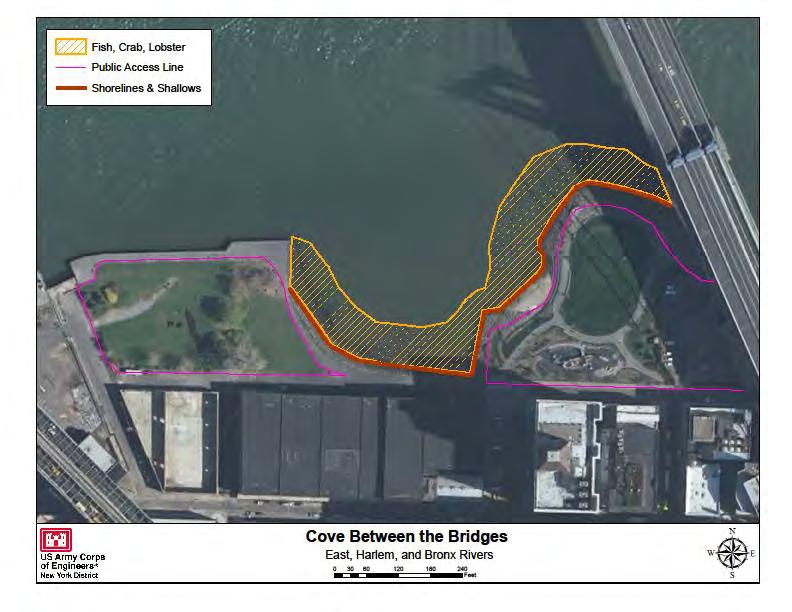
2 CRP SITE 677. COVE BETWEEN THE BRIDGES A. HARBOR ESTUARY PROGRAM SITE INFORMATION Category: Existing restoration, preservation, and/or mitigation site. Location: 0.2 miles north of the intersection of Main Street and Water Street in Brooklyn, NY. Between the Brooklyn Bridge and the Manhattan Bridge on the Brooklyn shore of the East River. Watershed: East River Size: 12 acres Ownership: Managed by the Brooklyn Bridge Park Development Corporation, a subsidiary of the Empire State Development Corporation. Site Description: The cove was formed by the waters of the estuary, which scoured it out over eighty to one hundred years. A former industrial waterfront site, the Cove is currently located within Brooklyn Bridge Park. The large rocks that edge the Cove were set in place in by the New York City Department of Parks and Recreation and the New York State Office of Parks, Recreation and Historic Preservation, have been strategically positioned as rip-rap to prevent the waters from carrying off any more land. Current Land Use: Parks and public land with active and passive recreation. Surrounding land use is industrial and open space. Available Habitat: Upland, beach, intertidal, shallow water. Species inhabiting the cove include Crustaceans such as Snails, Sandworms, Clams, Sand Shrimps, Blue Crabs, Green Crabs, Rock Crabs and Japanese Shore Crabs. Filter feeders include Blue Mussels and Oysters. The marine arthropod Horseshoe Crabs. The fish of cove include Silversides, Killifish, Mummichog, Bay Anchovy, Menhaden, Winter Flounder, White Perch, Striped Bass, Fluke, Porgies, Tautog, and Bluefish as well as other seasonal and migratory East River species. The cove also provides habitat, refuge and foraging ground for birds of the Atlantic flyway and many resident, seasonal, migratory, and waterbirds. (Complete fish, bird, and plant species list are available in the 2008 Field Guide). Proposed Project: Brooklyn Bridge Park has some 12 acres of continuous waterfront green space already built. An additional 73 acres (adjacent to the Cove site) will be built over the next few years, with two-thirds of the Park complete by Projected/Estimated Costs: Project Status: Partners: Project Contact: Phone: Website: Project Funding Source: HEP Ratification Date:
3 B. HUDSON RARITAN ESTUARY ECOSYSTEM RESTORATION STUDY INFORMATION Restoration Recommendations (Applicable Target Ecosystem Characteristics): Shorelines and Shallows - Restoration/enhancement of Sediment Contamination - Potential dredging and ~1,032 feet of shoreline and intertidal habitat. capping of contaminated sediment based on testing. Habitat for Fish, Crab and Lobsters Assess flats for Public Access - Support ongoing enhancements to composition, level of degradation and potential existing public access along ~2,484 feet of the river. enhancements to increase habitat connectivity- such as Including parks and areas for pedestrians and kayaking. addition of complex structure along ~1.7 acres of mudflats and potential addition of complex structure. Potential beneficial use of dredged material. Benefits, Cost and Comparative Restoration Ratio: C. EXISTING SITE SPECIFIC DATA INVENTORY A. Survey, Maps and GIS: Regional data exists inclusive of this site. B. Site History and Land Use: Brooklyn Bridge Park Conservancy C. Biological Studies/ Fauna: Brooklyn Bridge Park Conservancy D. Biological Studies/ General Environment: Brooklyn Bridge Park Conservancy E. Geotechnical: F. Hydraulics and Hydrology: G. Water and Sediment: H. Historical and Cultural Resources: I. Restoration Remediation and Design Plans: Brooklyn Bridge Park Conservancy *Work in progress REFERENCES: Brooklyn Bridge Park Conservancy The Cove Between the Bridges at Brooklyn Bridge Park, A Field Guide. Brooklyn Bridge Park Master Plan, USACE Hudson-Raritan Estuary Environmental Restoration Feasibility Study; Harlem River/East River/Western Long Island Sound Study Area Report.
4
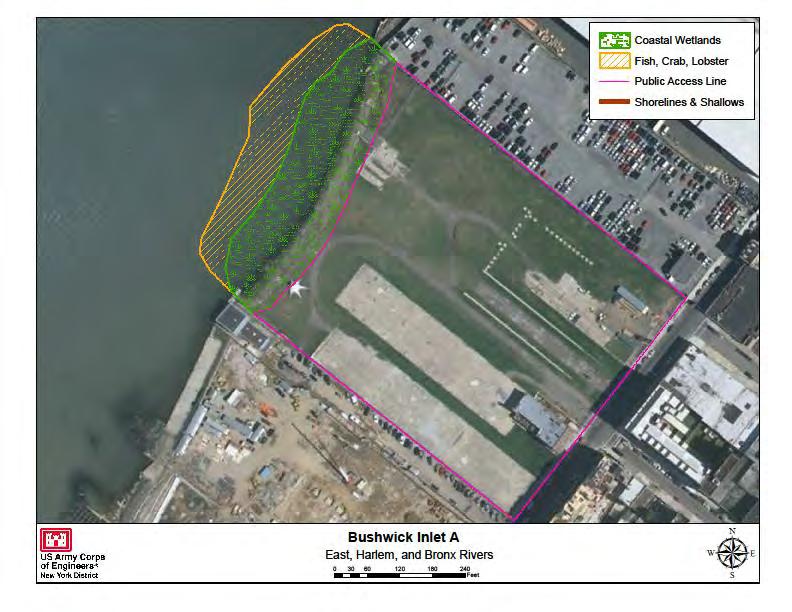
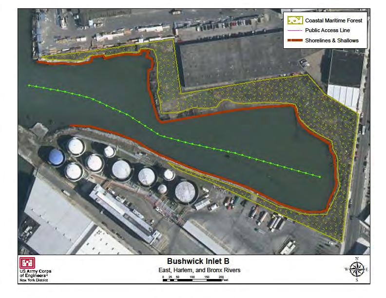
5 CRP SITE 676. BUSHWICK INLET A. HARBOR ESTUARY PROGRAM SITE INFORMATION Category: Existing restoration, preservation, and/or mitigation site. Location: Brooklyn Waterfront (Williamsburg- Greenpoint portion of the Brooklyn Greenway), adjacent to East River State Park. Watershed: East River Size: 28 acres Ownership: NYC, private. Site Description: Active and derelict marine terminal. Poor water quality, degraded benthos, Current Land Use: Park/public land, Active/derelict marine terminals. Surrounding parcels are zoned industrial, open space, industrial, vacant lot, commercial and transportation. Available Habitat: Potential Striped Bass habitat. Proposed Project: In 2005, New York City s rezoning of Williamsburg and Greenpoint mapped 28 acres of future waterfront parkland. Bushwick Inlet Park consists of the (Phase I) construction of a multi-purpose athletic field and the (Phase II) construction of a maintenance building/community space & shoreline. Conceptual designs are available from the NYC Parks Department. USACE (2001) recommends regrading of basins and shoreline; salt marsh creation in newly developed intertidal areas. Projected/Estimated Costs: Over $200 million has been budgeted by the City for the construction of parks and open spaces along the Greenpoint-Williamsburg waterfront. Two parcels of land have already been acquired for Bushwick Inlet Park with four more properties remaining. Project Status: Much of the design phase work has been completed, the acquisition and development of the underlying parkland is slow. At the time of the rezoning, six separate entities owned the 28 acres that comprise the park. To date, the City has acquired two of the six parcels and has begun development of one of them. The remaining four parcels await relocation of an existing business, are in legal limbo or require the city to negotiate a purchase. Phase I construction of the athletic field is complete. However, the future vision of the park remains uncertain. Partners: New York City Department of Parks and Recreation (NYCDPR) Project Contact: Phone: Website: Project Funding Source: HEP Ratification Date:
6 B. HUDSON RARITAN ESTUARY ECOSYSTEM RESTORATION STUDY INFORMATION Restoration Recommendations (Applicable Target Ecosystem Characteristics): Coastal Wetlands Creation of ~1.6 acres of salt marsh acres of mudflats along the East River. Potential along the East River shorelines. beneficial use of dredged material. Coastal and Maritime Forests Restoration/ Enclosed and Confined Waters Re-grading of basin enhancement of ~2.6 acres from scrub shrub habitat to and debris removal along ~1,055 feet will support proper upland fringe. depths and hydrology for restored habitat. Shorelines and Shallows Restoration of shoreline and Sediment Contamination - Potential dredging and intertidal habitat along ~2,520 feet in the basin and East capping of contaminated sediment based on testing. River to include shoreline softening, enhancements to Public Access - Support creation and/or enhancements shallow water habitat and debris removal. to existing public access along ~2,361 feet of the river. Habitat for Fish, Crab and Lobsters - Assess flats for Including parks, athletic fields and areas for pedestrians composition, level of degradation and potential and kayaking. enhancements to increase habitat connectivity- such as addition of complex structure along approximately ~0.81 Benefits, Cost and Comparative Restoration Ratio: C. EXISTING SITE SPECIFIC DATA INVENTORY A. Survey, Maps and GIS: Regional data exists inclusive of this site, Friends of Bushwick Inlet Park, USACE B. Site History and Land Use: USACE C. Biological Studies/ Fauna: D. Biological Studies/ General Environment: E. Geotechnical: F. Hydraulics and Hydrology: G. Water and Sediment: H. Historical and Cultural Resources: Location of Greenpoint Monitor Museum. I. Restoration Remediation and Design Plans: Friends of Bushwick Inlet Park, designs by AECOM Design and Planning. *Work in progress REFERENCES: USACE Restoration Opportunities in the Hudson-Raritan Estuary. U.S. Army Corps of Engineers, New York District, New York, NY. Friends of Bushwick Inlet Park- USACE Hudson-Raritan Estuary Environmental Restoration Feasibility Study; Harlem River/East River/Western Long Island Sound Study Area Report. Green Shores NYC and The Trust For Public Land Waterfront Vision Plan for Astoria and Long Island City, Queens. (public access)
7
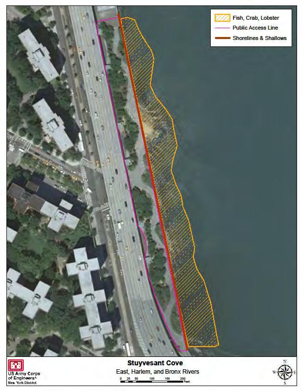
8 CRP SITE 673. STUYVESANT COVE A. HARBOR ESTUARY PROGRAM SITE INFORMATION Category: Existing restoration, preservation, and/or mitigation site. Location: Located along the East River between 18th and 23rd Streets in Manhattan. Watershed: East River Size: 1.9 acres. Ownership: Owned by New York City, maintained by Solar One. Site Description: Situated above a former brownfield site (former concrete factory and industrial uses) site contains a sustainable native plants park and environmental learning center. The park has been designated a Wildlife Habitat by the National Wildlife Federation for providing a quality habitat by virtue of its standards of conscientious planning, landscaping, and sustainable gardening. Stuyvesant Cove Park maintains an expanding offering of plants that are indigenous to the region including species such as Echinacea, Amelanchier, Tiarella and Quercus. Additionally, native grass species contribute to the biodiversity of the park as well as help sustain native bird species in the area. Surplus cement dumped from trucks into the East River has created a small beach in the middle of the park near the end of 20th Street. Current Land Use: Former industrial waterfront site. Surrounding land uses include; open space for active passive recreation, residential and transportation. Available Habitat: Estuarine habitat, monarch flyway. Proposed Project: Projected/Estimated Costs: Park restoration cost $8.3 million Project Status: The park was completed in Partners: NYC Economic Development Corporation Project Contact: Solar One Phone: (212) Website: info@solar1.org Project Funding Source: HEP Ratification Date:
9 B. HUDSON RARITAN ESTUARY ECOSYSTEM RESTORATION STUDY INFORMATION Restoration Recommendations (Applicable Target Ecosystem Characteristics): Shorelines and Shallows Creation of terraced tidal acres- removal of cement debris and rubble and flats where seawall removal is not an option will soften replacement with more natural reef structures. the shoreline and provide bird and fish refuge along Sediment Contamination - Potential dredging and ~1,106 feet of shoreline. capping of contaminated sediment based on testing. Habitat for Fish, Crab and Lobsters Assess flats for Public Access - Support enhancements to existing composition, level of degradation and potential public access along ~2,294 feet of the shoreline. enhancements to increase habitat connectivity- such as addition of complex structure along approximately ~1.98 Benefits, Cost and Comparative Restoration Ratio: C. EXISTING SITE SPECIFIC DATA INVENTORY A. Survey, Maps and GIS: B. Site History and Land Use: Solar 1 C. Biological Studies/ Fauna: Solar 1 D. Biological Studies/ General Environment: Solar 1 E. Geotechnical: F. Hydraulics and Hydrology: G. Water and Sediment: H. Historical and Cultural Resources: I. Restoration Remediation and Design Plans: Stuyvesant Cove Green Master Plan. *Work in progress REFERENCES: Solar 1- USACE Hudson-Raritan Estuary Environmental Restoration Feasibility Study; Harlem River/East River/Western Long Island Sound Study Area Report.
10
11 CRP SITE 672. ANABLE COVE A. HARBOR ESTUARY PROGRAM SITE INFORMATION Category: Existing restoration, preservation, and/or mitigation site. Location: Northwest of 44 th Drive, 0.1 miles east of Vernon Boulevard. Waterfront of Long Island City, NY. Watershed: East River Size: 3.5 acres Ownership: Department of Citywide Administrative Services. Site Description: Former industrial parcel which once served as industrial storage space, a dock repair facility and Standard Oil Company facilities. This site consists of a degraded pier, a grassy knoll covered in debris, and an asphalt covered lot. Current Land Use: Former industrial waterfront site. Surrounding land use includes; mixed use development, active and passive recreation, commercial, vacant lot, transportation, industrial and parking. Available Habitat: Estuarine habitat. Proposed Project: Proposed construction of a greenway along the edge of Anable Basin to connect with public space proposed at Anable Cove. Restoration of the natural landscape and marsh plants of Anable Cove; creation of a wildlife viewing walkway. Projected/Estimated Costs: Project Status: New Yorkers for Parks a citywide nonprofit advocacy group, has commissioned renderings of a viable design for Anable Cove under the auspices of its Community Design Project with the aid of landscape architecture students at the City College of New York. Partners: Hunters Point Community Coalition. Project Contact: Phone: Website: Project Funding Source: HEP Ratification Date:
12 B. HUDSON RARITAN ESTUARY ECOSYSTEM RESTORATION STUDY INFORMATION Restoration Recommendations (Applicable Target Ecosystem Characteristics): Coastal Wetlands Removal of dilapidated pier addition of complex structure along approximately ~0.34 structure and concrete with potential re-grading and use acres of mudflats. of clean fill to create proper elevations for ~0.46 acres of Sediment Contamination - Potential dredging and marsh creation. capping of contaminated sediment based on testing. Coastal and Maritime Forests Re-grading and use of Public Access - Support enhancements to existing clean fill to create ~0.38 acres of mixed upland scrub public access and greenway connections along ~462 feet shrub habitat. as part of the Queens East River and North Shore Habitat for Fish, Crab and Lobsters Assess flats for Greenway Plan. composition, level of degradation and potential enhancements to increase habitat connectivity- such as Benefits, Cost and Comparative Restoration Ratio: C. EXISTING SITE SPECIFIC DATA INVENTORY A. Survey, Maps and GIS: B. Site History and Land Use: C. Biological Studies/ Fauna: D. Biological Studies/ General Environment: E. Geotechnical: F. Hydraulics and Hydrology: G. Water and Sediment: H. Historical and Cultural Resources: I. Restoration Remediation and Design Plans: Hunters Point Community Association and NY4P, Green Shores NYC and The Trust For Public Land. *Work in progress REFERENCES: Marc Ferris Mission to restore Anable Cove. New York Newsday. New York City Department of City Planning Queens East River & North Shore Greenway Master Plan. New Yorkers for Parks USACE Hudson-Raritan Estuary Environmental Restoration Feasibility Study; Harlem River/East River/Western Long Island Sound Study Area Report. The City of New York Department of City Planning Vision 2020 New York City Comprehensive Waterfront Plan. Green Shores NYC and The Trust For Public Land Waterfront Vision Plan: Astoria and Long Island City, Queens. (public access)

13
14 CRP SITE 674. HALLETS COVE A. HARBOR ESTUARY PROGRAM SITE INFORMATION Category: Existing restoration, preservation, and/or mitigation site. Location: 0.5 miles southwest of intersection of Main Avenue and 31st street, Waterfront of Long Island City NY. To the north of the site are the Astoria Houses Esplanade, Two Coves Community Garden, and the New York City Housing Authority (NYCHA) Astoria Houses. To the south is Socrates Sculpture Park. Watershed: East River Size: Ownership: Site Description: Former industrial waterfront parcel. The cove serves as a public docking area and is heavily used by kayakers and environmental education programs. The site contains a 27,750 square foot lot featuring a dilapidated pier and radio tower. Previously used as an illegal dumping ground for solid waste. Public access to the site is restricted by a fence along Vernon Boulevard. Current Land Use: Some areas of parks and public land. Surrounding land use is a mix of industrial, residential and vacant lot. Available Habitat: Estuarine habitat. Proposed Project: LIC Community Boat House is currently raising funds to build a kayak launch and boat storage house. Projected/Estimated Costs: Project Status: NYC Parks implemented a 1 acre wetland restoration in 1993 along the southern portion of Halletts Cove. Status of this restoration should be examined prior to conducting further restoration measures. Partners: Project Contact: Phone: Website: Project Funding Source: HEP Ratification Date:
15 B. HUDSON RARITAN ESTUARY ECOSYSTEM RESTORATION STUDY INFORMATION Restoration Recommendations (Applicable Target Ecosystem Characteristics): Coastal Wetlands - Restoration/creation of ~0.30 acres Shorelines and Shallows- Shoreline softening, of wetlands, which may require some placement of clean stabilization and debris removal along ~618 feet. fill and re-grading. Sediment Contamination - Potential dredging and Habitat for Fish, Crab and Lobsters- Assess flats for capping of contaminated sediment based on testing. composition, level of degradation and potential Public Access - Support enhancements (boat launch) to enhancements to increase habitat connectivity- such as existing public access and greenway connections as part addition of complex structure along approximately ~0.44 of the Queens East River and North Shore Greenway acres of intertidal mudflats. Plan. Benefits, Cost and Comparative Restoration Ratio: C. EXISTING SITE SPECIFIC DATA INVENTORY A. Survey, Maps and GIS: B. Site History and Land Use: C. Biological Studies/ Fauna: D. Biological Studies/ General Environment: E. Geotechnical: F. Hydraulics and Hydrology: G. Water and Sediment: H. Historical and Cultural Resources: I. Restoration Remediation and Design Plans: Green Shores NYC and The Trust For Public Land. *Work in progress REFERENCES USACE Hudson-Raritan Estuary Environmental Restoration Feasibility Study; Harlem River/East River/Western Long Island Sound Study Area Report. Metropolitan Waterfront Alliance- The City of New York Department of City Planning Vision 2020 New York City Comprehensive Waterfront Plan. Green Shores NYC and The Trust For Public Land Waterfront Vision Plan: Astoria and Long Island City, Queens. (public access) Alderson, Carl and Justin Bowers Reaching for the Past in Pursuit of the future: how can our present and past efforts inform the Hudson-Raritan Estuary Comprehensive Restoration Plan and the direction of habitat restoration going forward. A project for the New York-New Jersey Harbor & Estuary Program and New England Interstate Water Pollution Control Commission.

16
17 CRP SITE 10. SOUTH BROTHER ISLAND A. HARBOR ESTUARY PROGRAM SITE INFORMATION Category: Existing restoration, preservation, and/or mitigation site. Location: East River, north of Hell Gate, just off of Hunts Point. Watershed: Long Island Sound Size: 7 Acres Ownership: NYCDPR Site Description: Uninhabited island and nature preserve in the East River. The island consists of mixed intertidal rock and flats, the east end of the island is shallow water and sandy beach, along with exposed rock outcrops; mostly forested upland. One of the primary nesting sites for herons and egrets in the harbor. South Brother Island hosts the largest wading bird population in the New York Harbor. The island s bird population also includes ibises, oyster catchers, cormorants and egrets. In its forest are locust, white mulberry and black cherry trees, covered by thick tangles of oriental bittersweet vines that cover trees and ground alike. Because there are no predators on the island, many birds build their nests on the ground. Current Land Use: Part of the Harbor Herons Wildlife Refuge. Land use is zoned as open space, park and vacant land. Available Habitat: Forest, Grassland/Shrubland, Aquatic/Marine, Beach/Dune. Proposed Project: Currently, nesting birds must fly several miles to find intertidal wetlands for foraging; creation of several acres of intertidal salt marsh on the east end of the island would benefit these birds and their fledglings by providing a nearby foraging site. Offshore wave attenuation structures may be necessary due to the strong current regime in the area. Projected/Estimated Costs: Project Status: Acquired by NYC DPR in 2007 Partners: Audubon, Trust for Public Land, Wildlife Conservation Society, The Point. Project Contact: Michael Feller, NYC Parks/NRG Phone: (212) Website: Project Funding Source: HEP Ratification Date: 12/11/1997
18 B. HUDSON RARITAN ESTUARY ECOSYSTEM RESTORATION STUDY INFORMATION Restoration Recommendations (Applicable Target Ecosystem Characteristics): Islands for Waterbirds Already home to colonial Shorelines and Shallows Debris removal along nesting bird rookeries, this island would benefit from ~1.906 feet of shoreline. TEC upgrades to bird habitat, potential use of clean Sediment Contamination - Potential dredging and materials from South Brothers Island Channel capping of contaminated sediment based on testing. maintenance. Coastal and Maritime Forests Reduce invasive species and increase shrub habitat along ~4.29 acres. Potential to improve dune habitat. Benefits, Cost and Comparative Restoration Ratio: C. EXISTING SITE SPECIFIC DATA INVENTORY A. Survey, Maps and GIS: B. Site History and Land Use: C. Biological Studies/ Fauna: NYC Audubon Harbor Herring nesting surveys. D. Biological Studies/ General Environment: FWS Habitat Rating form (1992). E. Geotechnical: F. Hydraulics and Hydrology: G. Water and Sediment: H. Historical and Cultural Resources: I. Restoration Remediation and Design Plans: *Work in progress REFERENCES: USACE Restoration Opportunities in the Hudson-Raritan Estuary. U.S. Army Corps of Engineers, New York District, New York, NY. News York Times Articlehttp:// r=permalink&exprod=permalink Harbor Herrings Nesting Survey- USACE Hudson-Raritan Estuary Environmental Restoration Feasibility Study; Harlem River/East River/Western Long Island Sound Study Area Report. USACE South Brothers Island Channel Fact Sheethttp:// Forever Wild- FWS Habitat Rating Form-

19
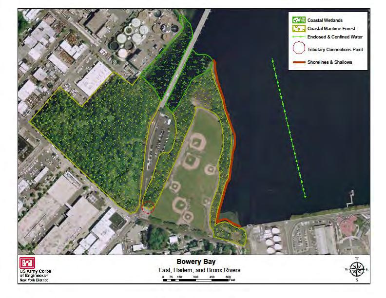
20 CRP SITE 170. BOWERY BAY A. HARBOR ESTUARY PROGRAM SITE INFORMATION Category: Existing restoration, preservation, and/or mitigation site. Location: Inland bay located along the East River near the Steinway neighborhood of Queens. It is bordered on the west by the Bowery Bay Water Pollution Control Plant and on the south and east by LaGuardia Airport. Watershed: Long Island Sound Size: 40 acres Ownership: Site Description: Current Land Use: Land use in the area is characterized by manufacturing and parking use. The area is highly developed. There are several vacant lots in the south east portion of the site. These lots are contained within the New York and New Jersey Harbor Estuary Protection Program, and no development plans for them are in action. Land use includes vacant land, open space, parking and transportation. Surrounding land use is primarily transportation and industrial. Available Habitat: Estuarine - marshes, tidal waterways, intertidal flats, estuarine embayment. Located near colonial water bird rookeries. Proposed Project: Salt Marsh Restoration Projected/Estimated Costs: Project Status: Partners: NRDC Project Contact: Phone: Website: Project Funding Source: HEP Ratification Date: 12/11/1997
21 B. HUDSON RARITAN ESTUARY ECOSYSTEM RESTORATION STUDY INFORMATION Restoration Recommendations (Applicable Target Ecosystem Characteristics): Coastal Wetlands Salt marsh restoration along ~4.96 Tributary Connections Assessment of channel banks acres of the vacant lots directly south east of the WPCP and culvert capacity across Rikers Island Bridge Road to may include include plantings and possible re-grading. potentially open up ~0.20 feet of creek. Coastal and Maritime Forests Improvements to Enclosed and Confined Waters - Water quality upland shrub buffer and forest improvements along improvements are expected along ~3,000 feet of the ~27.22 acres to include assessment of invasive species. Bowery Bay adjacent to the site as major improvements Shorelines and Shallows- Shoreline softening, bank to the wastewater treatment plant are planned. stabilization and removal of debris along ~1.804 feet of Sediment Contamination - Potential dredging and shoreline. capping of contaminated sediment based on testing. Benefits, Cost and Comparative Restoration Ratio: C. EXISTING SITE SPECIFIC DATA INVENTORY A. Survey, Maps and GIS: B. Site History and Land Use: C. Biological Studies/ Fauna: D. Biological Studies/ General Environment: E. Geotechnical: F. Hydraulics and Hydrology: G. Water and Sediment: H. Historical and Cultural Resources: I. Restoration Remediation and Design Plans: *Work in progress References USACE Hudson-Raritan Estuary Environmental Restoration Feasibility Study; Harlem River/East River/Western Long Island Sound Study Area Report. Green Shores NYC and The Trust For Public Land Waterfront Vision Plan: Astoria and Long Island City, Queens. (public access) *Proximity to La Guardia Airport may limit habitat restoration opportunities.
22
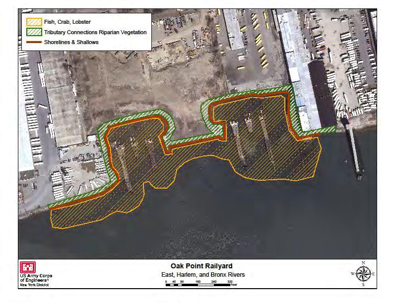
23 CRP SITE 666. OAK POINT RAIL YARD A. HARBOR ESTUARY PROGRAM SITE INFORMATION Category: Existing restoration, preservation, and/or mitigation site. Location: Southwest Bronx, north shore upper East River. Watershed: East River Size: 100 acres. Ownership: Private, NYSDEC Site Description: Degraded wetlands adjacent to landfill and rail yard with hydrologic restrictions due to fill material and landfill. Close proximity to North and South Brother Islands (wildlife preserves) add value to the tidal wetlands on this property. There are several proposals to build industrial facilities on this parcel. Current Land Use: Industrial and vacant lot parcel with degraded estuarine waterfront. Available Habitat: Proposed Project: Remediate areas damaged by landfill, restoration of wetlands. Projected/Estimated Costs: Project Status: The Oak Point Eco-Industrial Park: A Sustainable Economic Development Proposal for the South Bronx. Oak Point partners completed wetland restoration work on the site in It was subsequently wiped out by superstorm Sandy, but was scheduled for reconstruction in Partners: NYSDEC (under Long Island Sound Study - LISS) Project Contact: Phone: Website: Project Funding Source: HEP Ratification Date:
24 B. HUDSON RARITAN ESTUARY ECOSYSTEM RESTORATION STUDY INFORMATION Restoration Recommendations (Applicable Target Ecosystem Characteristics): Tributary Connections Restoration to ~1.35 acres of Habitat for Fish, Crab and Lobsters Assess flats for riparian habitat in the shore areas surrounding the Rail composition, level of degradation and potential Yard. Potential invasive removal and native species enhancements to the ~7.28 acres of dilapidated pier plantings. structures. Shorelines and Shallows - Shoreline enhancement Sediment Contamination - Potential dredging and along ~2,455 feet in the areas surrounding the Rail Yard. capping of contaminated sediment based on testing. Potential to include debris removal and potential regrading to stabilize banks. Benefits, Cost and Comparative Restoration Ratio: C. EXISTING SITE SPECIFIC DATA INVENTORY A. Survey, Maps and GIS: B. Site History and Land Use: C. Biological Studies/ Fauna: D. Biological Studies/ General Environment: E. Geotechnical: F. Hydraulics and Hydrology: G. Water and Sediment: H. Historical and Cultural Resources: I. Restoration Remediation and Design Plans: *Work in progress REFERENCES: USACE Restoration Opportunities in the Hudson-Raritan Estuary. U.S. Army Corps of Engineers, New York District, New York, NY. Sustainable South Bronxhttp:// USACE Hudson-Raritan Estuary Environmental Restoration Feasibility Study; Harlem River/East River/Western Long Island Sound Study Area Report.
25
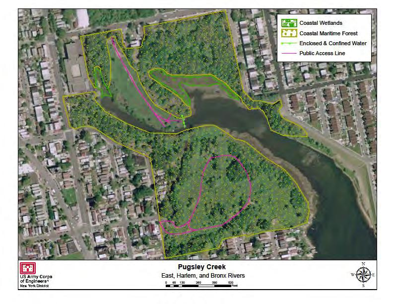
26 CRP SITE 175. PUGSLEY CREEK A. HARBOR ESTUARY PROGRAM SITE INFORMATION Category: Existing restoration, preservation, and/or mitigation site. Location: Tributary of Westchester Creek, Bronx NY. Watershed: Long Island Sound Size: Entire park is 77 acres. Marsh restoration occurred along 2.15 acres. Ownership: NYC Site Description: Pugsley Creek is a 77-acre park is largely filled, undeveloped and mostly abandoned by people. Historically Pugsley Creek was once bordered by hundreds of acres of salt marsh, but now is dominated by black locusts, box elders, cottonwoods, and Ailanthus with fields of mugwort and scattered stands of Japanese knotweed and Phragmites. Along the creek are bands of Spartina alternaflora. There are remnants of the forested floodplain, once very common in the region, typified by large trees, an open understory and a forest floor of rich alluvial soil. New York sewage overflow (CSO) pipeline was constructed along Barret Avenue that discharges just where the channel narrows, about halfway up the creek. The pipeline impacted upland areas by discharging fill resulting in the spread of exotic invasive species and degraded water quality in the creek. Exotic vegetation that flourished in upland areas resulting from the CSO pipeline are mugwort, Queen Anne s lace, Phragmites, Norway maple, sycamore maple, and others. Current Land Use: Open space/ parks, vacant lot. Available Habitat: Estuarine/ marine, marsh. Proposed Project: Salt marsh restoration, 1.5 acre salt marsh and 0.75 acres upland buffer restoration; project goals included excavation of 3,825 yd3 fill and re-grading to proper elevation for a tidal creek system dominated by low marsh. Projected/Estimated Costs: $1,700,000; expected cost $1,250,000 Project Status: 2002 BA award for $850,000. Salt marsh restoration is in construction along the eastern shore of the creek south of Norton Avenue. Anticipated completion: Fall 2011; this restoration should be reviewed before proceeding with further planning for this site. Partners: NYCDEC. Project Contact: Michael Feller, NYC Parks/NRG Phone: (212) Website: Project Funding Source: NYSCWCA 2002 HEP Ratification Date: 12/11/1997
27 B. HUDSON RARITAN ESTUARY ECOSYSTEM RESTORATION STUDY INFORMATION Restoration Recommendations (Applicable Target Ecosystem Characteristics): Coastal Wetlands Restoration to ~1.51 acres of Enclosed and Confined Assessment of CSO at Barret existing native wetland and upland marsh areas which Ave. for BMP s. are currently dominated by invasive species. Restoration Sediment Contamination - Potential dredging and to include invasive removal and assessment for regrading to proper elevations. Public Access - A baseball field is located on Puglsey capping of contaminated sediment based on testing. Coastal and Maritime Forests Improvements to and Randall Avenues just north of Lacombe. Potential to ~13.2 acres of upland forested areas to include removal improve upon the ~3,557 foot walking trail system for of invasive species. passive waterfront access. Benefits, Cost and Comparative Restoration Ratio: C. EXISTING SITE SPECIFIC DATA INVENTORY A. Survey, Maps and GIS: B. Site History and Land Use: C. Biological Studies/ Fauna: D. Biological Studies/ General Environment: NYC Parks Natural Area Mapping and Inventory, E. Geotechnical: F. Hydraulics and Hydrology: G. Water and Sediment: H. Historical and Cultural Resources: Archaeological site near the head of Pugsley Creek (NYC Parkswebpage) I. Restoration Remediation and Design Plans: *Work in progress REFERENCES: NYC Parks- NYC Parks NRG Ecological Assessment- Compilation of reports- Alderson, Carl and Justin Bowers Reaching for the Past in Pursuit of the future: how can our present and past efforts inform the Hudson-Raritan Estuary Comprehensive Restoration Plan and the direction of habitat restoration going forward. A project for the New York-New Jersey Harbor & Estuary Program and New England Interstate Water Pollution Control Commission.
28
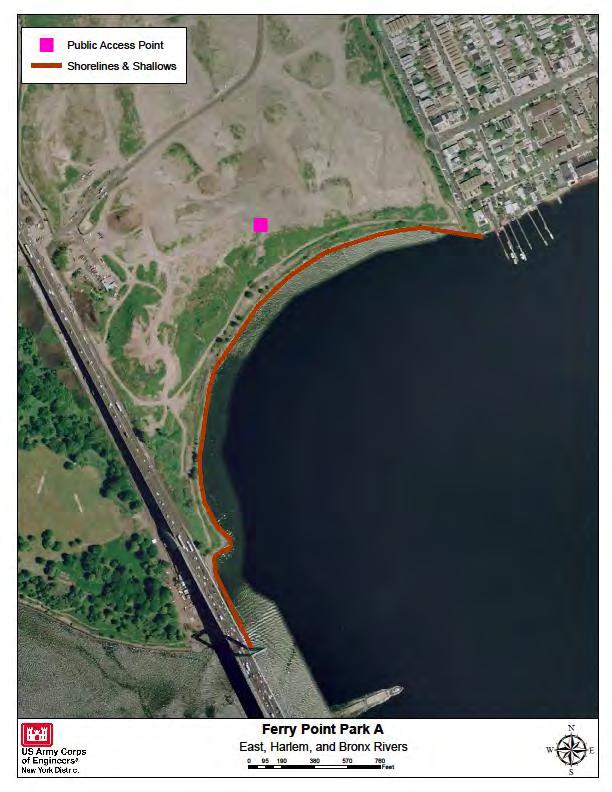
29 CRP SITE 648. FERRY POINT PARK A. HARBOR ESTUARY PROGRAM SITE INFORMATION Category: Existing restoration, preservation, and/or mitigation site. Location: East River, Bronx - The site is located in the Bronx adjacent to the Whitestone Bridge and is bounded by the Hutchinson River Parkway, the East River, Schley Avenue, Emerson Avenue, and Balcom Avenue. Watershed: No data. Size: 24 Acres; acres total Ownership: New York City Department of Parks and Recreation Site Description: Ferry Point Park is divided in half, with the east side a common reed (Phragmites australis) plantation and the west a landscaped parkland, all growing on landfill. Bits of salt marsh and beach hug the park s shores. Current Land Use: Open space/park with active and passive recreation. Surrounding lots are zoned residential, industrial, vacant and commercial. Available Habitat: Estuarine/marine, salt marsh. Open space parkland is dominated by Phragmites with low value upland vegetation and fill. Pioneering cottonwoods (Populus), cherries (Prunus), birches (Betula,), and willows (Salix) have broken through the reeds in the east. The manicured parkland flanking Westchester Creek s outlet has grown more wild. High grasses and herbs, numerous saplings, and unpruned hornbeam trees (Carpinus) provide excellent wildlife habitat. Uncommon winter birds, like the snowy owl (Nyctea scandiaca), can be observed at Ferry Point Park. Proposed Project: NYCDPR is in the process of creating parkland and a waterfront promenade. The projects involve the rehabilitation of athletic fields, new comfort stations, a waterfront park, and a signature golf course. The Community Park Phase I was slated for completion by November A separate 20-acre waterfront promenade will convert undeveloped parkland into a passive ecologically responsible park. The City is developing a new 19.5-acre park along the Ferry Point Waterfront. Currently in the design phases, this project will create an ecologically minded waterfront park. This design will accelerate the ecological restoration of the site by re-establishing historic maritime ecologies and tidal habitats and make the park an icon for the local community and the City at large. Waterfront Park is anticipated to begin construction in winter 2013, and be complete in spring 2014 Projected/Estimated Costs: Project Status: Anticipated completion of community park is Winter Partners: NYCDEC, NRDC Project Contact: Phil Abramson/ Jesslyn Moser (Parks) Phone: (212) Website: Project Funding Source: No data. HEP Ratification Date: No data.
30 B. HUDSON RARITAN ESTUARY ECOSYSTEM RESTORATION STUDY INFORMATION Restoration Recommendations (Applicable Target Ecosystem Characteristics): Coastal Wetlands Restoration and creation of ~5.7 Habitat for Fish, Crab and Lobsters Clean up of acres of fringe marsh habitat in Ferry Point Park west. heavily debris laden shoreline and assess flats for Potential marsh creation by NYC Parks in Ferry Point composition, level of degradation and potential Park east, waterfront park. enhancements to increase habitat connectivity- such as Coastal and Maritime Forests Restoration and addition of complex structure should take place along creation of ~7.55 acres of upland vegetation buffer and approximately ~10.67 acres of mudflats. forested patches in the northern portion of Ferry Point Sediment Contamination - Potential dredging and Park west. capping of contaminated sediment based on testing. Shorelines and Shallows - Shoreline softening along Public Access Support to NYC Parks ongoing public ~5,645 feet with improvements to intertidal habitat and access restoration. debris removal. Benefits, Cost and Comparative Restoration Ratio: C. EXISTING SITE SPECIFIC DATA INVENTORY A. Survey, Maps and GIS: B. Site History and Land Use: C. Biological Studies/ Fauna: D. Biological Studies/ General Environment: E. Geotechnical: F. Hydraulics and Hydrology: G. Water and Sediment: H. Historical and Cultural Resources: I. Restoration Remediation and Design Plans: *Work in progress REFERENCES: USACE Restoration Opportunities in the Hudson-Raritan Estuary. U.S. Army Corps of Engineers, New York District, New York, NY. NYC Parks USACE Hudson-Raritan Estuary Environmental Restoration Feasibility Study; Harlem River/East River/Western Long Island Sound Study Area Report.
31
32
33 CRP SITE 107. MEADOW LAKE/FLUSHING CREEK A. HARBOR ESTUARY PROGRAM SITE INFORMATION Category: Existing restoration, preservation, and/or mitigation site. Location: Flushing Meadow Corona Park (FMCP), approximately 2 miles south of Flushing Bay. Watershed: Long Island Sound Size: 84 acres Ownership: New York City Department of Parks & Recreation (NYCDP&R), NYC. Site Description: Meadow Lake, New York City's largest lake, is a shallow, freshwater impoundment created as a result of filling tidal wetlands at the south end of Flushing Bay. Between 1906 and 1934, the site was filled with ash and garbage. Historic maps prior to the 39 Fair show the Flushing Creek meandering along widely varying routes through what later became the park. A tidal dam was built across the Flushing Creek and the Creek was reconfigured into two lakes for the 1939 World s Fair. Further change to the Creek, now configured as a River, came as a result of the grand design for the 1964 World s Fair. The Unisphere, an iconic fountain located in the historic World s Fair Core was built at one end of a long axis that terminated with an enormous circular fountain, called the Fountain of the Planets. The Flushing River was relocated underground in a culvert on either side of the Fountain of the Planets and fed the fountain. Currently, the lakes are highly eutrophic. This is largely due to nutrients in the subsoil seeping up into the water. There is some lead and petroleum contamination. Shallow lake depths limit fish habitat and boating activities. Invasive plant and fish species have replaced more desirable species. Current Land Use: Open space/park with active passive recreation, Available Habitat: Freshwater wetland with emergent and forest scrub habitat. Birds observed at Meadow Lake include waterfowl such as Canada goose, American black duck, mallard, ruddy duck, red-breasted merganser. Gulls identified included greater black-backed gull, herring gull, laughing gull, ring-billed gull, glaucous gull. Wading birds such as the great blue heron, spotted sandpiper, least sandpiper, great egret were identified. Swallows were seen feeding on insects over the water s surface (barn swallow, tree swallow, rough winged swallow), and a number of other species (rock dove, mourning dove, European starling, house sparrow) were noted. Red-winged blackbird, common yellowthroat, yellow warbler, and belted kingfisher were observed using the wetland fringe. The open waters of Meadow Lake provide refuge and feeding opportunities for the waterfowl and gulls. Wading birds forage at the wetland fringe, but are frequently disturbed by people using walking trails. Other birds utilized the wetland fringe for foraging. Nesting is of low success due to the limited locations secluded enough to provide protection. Proposed Project: Nutrient Reduction/restoration, $144,000 maritime heathland restoration, Shoreline stabilization and freshwater. Projected/Estimated Costs:~ $5,000,000 Project Status: The FMCP Strategic Framework Plan outlines guiding principles for the long term vision of the park. Plans include a re-envisioning of the World s Fair Core, reconfiguration and restoration of the lakes and reconnection of the park to the neighborhood and city. The Strategic Framework Plan suggests that studies in transportation and parking, tree surveys, tide gate and lakes and drainage take place before detailed planning. A shoreline stabilization and freshwater wetland planting was implemented by NYCDP&R in 2005 along 200 linear feet of shoreline in the northwest portion of Meadow Lake across from 63 rd Ave. Partners: NYCDP&R. Project Contact: Marit Larsen, NYCDP&R Phone: (212)
34 Website: Project Funding Source: NYSCWCA HEP Ratification Date: 3/4/1999 B. HUDSON RARITAN ESTUARY ECOSYSTEM RESTORATION STUDY INFORMATION Restoration Recommendations (Applicable Target Ecosystem Characteristics): Coastal Wetlands Restoration/ creation of ~10.9 acres dredging of Meadow Lake to increase flow and fish of intertidal fringe wetlands and mudflats along the habitat. perimeter of Meadow Lake. Sediment Contamination - Potential dredging and Enclosed and Confined Waters Removal of invasive capping of contaminated sediment based on testing. species along ~3,726 feet of creek corridor and potential Public Access Support to NYC DPR ongoing Public Access improvements. Benefits, Cost and Comparative Restoration Ratio: C. EXISTING SITE SPECIFIC DATA INVENTORY A. Survey, Maps and GIS: FMCP Strategic Framework Plan. B. Site History and Land Use: FMCP Strategic Framework Plan. C. Biological Studies/ Fauna: USACE 2007 D. Biological Studies/ General Environment: HDR/LMS for FMCP, USACE 2007 E. Geotechnical: F. Hydraulics and Hydrology: G. Water and Sediment: USACE 2007 H. Historical and Cultural Resources: USACE 2007 I. Restoration Remediation and Design Plans: FMCP Strategic Framework Plan. *Work in progress REFERENCES: Flushing Meadow Corona Park (FMCP) Strategic Framework Planhttp:// USACE Flushing Bay and Creek Ecosystem Restoration Feasibility Study. USACE Hudson-Raritan Estuary Environmental Restoration Feasibility Study; Harlem River/East River/Western Long Island Sound Study Area Report. Alderson, Carl and Justin Bowers Reaching for the Past in Pursuit of the future: how can our present and past efforts inform the Hudson-Raritan Estuary Comprehensive Restoration Plan and the direction of habitat restoration going forward. A project for the New York-New Jersey Harbor & Estuary Program and New England Interstate Water Pollution Control Commission.
35
36 CRP SITE 188. FLUSHING CREEK A. HARBOR ESTUARY PROGRAM SITE INFORMATION Category: Existing restoration, preservation, and/or mitigation site. Location: 0.1 miles west of the Whitestone Expressway, 1.2 miles south of College Point Boulevard, Queens NY. Watershed: Long Island Sound Size: Ownership: NY City Site Description: Flushing Creek flows approximately 7,000-feet, from the outlet of Meadow Lake, before entering Flushing Bay. Prior to landfills and development in preparation for the 1939 World s Fair, Flushing Creek was a sinuous tidal creek that supported an extensive tidal wetland system. Development of the World s Fair site included significant straightening of the stream, filling in wetland areas, and reconfiguring the headwaters of Flushing Creek into two manmade freshwater lakes. Willow Lake (40 acres) and Meadow Lake (100 acres) were created to support World Fair activities. Flushing Creek was also diverted through underground culverts to flow through a fountain structure prior to reaching the tide gates at Porpoise Bridge. Within Flushing Meadows-Corona Park, Willow Lake drains into Meadow Lake. Meadow Lake discharges to Flushing Creek. Immediately downstream of Meadow Lake, the creek flows under the elevated highway infrastructure for approximately 2,500-feet. When it reaches a culvert, the flows are directed underground for 1,000-feet to the fountain structure. Below fountain structure, the creek reenters an underground culvert that directs flow for another 1,000-foot at which point the creek is discharged to a pond. This is at the head of the tide gates. The Flushing Creek water shed is small and the lower portion is predominantly bulk headed. The low freshwater flows are not sufficient to open the tidal gate. Flushing Creek therefore contributes only a small portion of the total inflow to Flushing Bay. Inter-tidal emergent marshlands persist along the western bank of Flushing Creek. Current Land Use: Open space/ parks with active and passive restoration. Available Habitat: Intertidal marsh, degraded estuarine habitat. Flushing Creek is dominated by disturbed species such as common reed (Phragmites australis), field horsetail (Equisetum arvense), chicory (Chichorium intybus), Common plaintain (Plantago major). A native shrub marsh elder (Iva frutescens) is present in the high tide to spring tide range. Native salt marsh cord grass (Spartina alterniflora) is present along a narrow band. Birds observed in lower Flushing Creek include waterfowl (mallard, canvasback, lesser scaup, wood duck) and wading birds (cattle egret, snowy egret, great egret). Proposed Project: Salt marsh restoration, freshwater wetlands restoration, dredging; and (6) shoreline bank stabilization, site cleanup and debris removal. Projected/Estimated Costs: Project Status: USACE Study: A reconnaissance report was completed in April 1996, which demonstrated a federal interest for further study at the feasibility level. It identified six measures in the interest of ecosystem restoration: (1) Tidal Wetlands Restoration; (2) Freshwater Wetlands Restoration; (3) Dredging; (4) Further Removal of the Earthen Dike; (5) Reorientation of the Federal Navigation Channel; and (6) Shoreline Bank Stabilization, Site Cleanup and Debris Removal. There are two non-federal co-sponsors for the feasibility study, the Port Authority of New York and New Jersey (PANYNJ) and the New York City Department of Environmental Protection (NYCDEP). The feasibility study began in October A numerical hydrodynamic model was used to examine tidal current circulation patterns. The Flushing Bay hydrographic survey was completed in May 2000, while the Bay water quality sampling program and the tidal current and stage data-gathering program were completed in October In addition, inter-tidal wetlands delineation
37 was completed during summer Aerial photography of the study area was flown in April A preliminary formulation of alternatives report was prepared in Currently, the Corps, the NYCDEP and PANYNJ have agreed to pursue recommendations for Flushing Creek, including the restoration and dredging components, which are expected to be environmentally sustainable with the implementation of the NYCDEP abatement facility of the most influential sewage outfall. The draft feasibility report and public review period are scheduled to be completed and finalized in The FMCP Strategic Framework Plan: The Plan outlines guiding principles for the long term vision of the park. Plans include a re-envisioning of the World s Fair Core, reconfiguration and restoration of the lakes and reconnection of the park to the neighborhood and city. The Strategic Framework Plan suggests that studies in transportation and parking, tree surveys, tide gate and lakes and drainage take place before detailed planning. A 1.54 acres wetland and 0.93 acres upland mitigation was completed in 2008 by NYC DOT. The site is located on the west bank of Flushing Creek, just south of the intersection of Flushing Creek and 25A. Primary restoration activities were fill removal followed by plantings. Partners: NYCDEP, USACE, PANYNJ, NYCEDC Project Contact: Ronald Pinzon (USACE), NYC EDC Phone: (917) (USACE), (212) (NYCEDC) Website: ronald.r.pinzon@usace.army.mil Project Funding Source: HEP Ratification Date: 12/11/1997 B. HUDSON RARITAN ESTUARY ECOSYSTEM RESTORATION STUDY INFORMATION Restoration Recommendations (Applicable Target Ecosystem Characteristics): Coastal Wetlands - The site for this restoration project Shorelines and Shallows Shoreline bank stabilization includes sections of the left descending bank of Flushing and debris removal along ~12,578 feet of the river. Creek between the Van Wyck Expressway (Route 678) Tributary Connections Assessment of tide gates and crossing at the mouth, to the tidal gates at Porpoise culverts; daylighting and re-configuration of ~12,578 Bridge beyond the New York City Transit Authority feet of creek. Stream corridor restoration includes yard and rail crossing. Widen the existing low and high dredging selected areas of the creek (removal of the top tidal marsh, by lowering the grade through the presently 2 8 feet of sediments) coupled with replacement of Phragmites-dominated high marsh wetlands and clean sediments (possibly beneficial use of dredged adjacent ruderal uplands. There is an opportunity here to material) would reduce concentrations of total organic restore about 6.5-acres of low tidal marsh, where there carbon in the sediments and improve substrate quality. are currently scattered areas that total about one acre. Coarse substrate materials could be used to attract fish Coastal and Maritime Forests Creation of ~6.04 into the inner bay and creek. acres of riparian forest boarding the newly created Sediment Contamination - Potential dredging and marsh. capping of contaminated sediment based on testing. Benefits, Cost and Comparative Restoration Ratio: C. EXISTING SITE SPECIFIC DATA INVENTORY A. Survey, Maps and GIS: FMCP Strategic Framework Plan, Alderson & Bowers, B. Site History and Land Use: FMCP Strategic Framework Plan C. Biological Studies/ Fauna: USACE 2007 D. Biological Studies/ General Environment: USACE 2007 E. Geotechnical: F. Hydraulics and Hydrology: USACE 2007 G. Water and Sediment: USACE 2007 H. Historical and Cultural Resources: USACE 2007 I. Restoration Remediation and Design Plans: FMCP Strategic Framework Plan, USACE 2007, Alderson & Bowers, 2012.
38 *Work in progress REFERENCES: Flushing Meadow Corona Park (FMCP) Strategic Framework Planhttp:// USACE Flushing Bay and Creek Ecosystem Restoration Feasibility Study. USACE Ecosystem Restoration Study- HRE Workshop Transcript- USACE Hudson-Raritan Estuary Environmental Restoration Feasibility Study; Harlem River/East River/Western Long Island Sound Study Area Report. Alderson, Carl and Justin Bowers Reaching for the Past in Pursuit of the future: how can our present and past efforts inform the Hudson-Raritan Estuary Comprehensive Restoration Plan and the direction of habitat restoration going forward. A project for the New York-New Jersey Harbor & Estuary Program and New England Interstate Water Pollution Control Commission.

39
40 CRP SITE 680. TIBBETTS BROOK A. HARBOR ESTUARY PROGRAM SITE INFORMATION Category: Existing restoration, preservation, and/or mitigation site. Location: Tributary of Harlem River, flowing south through west Bronx, Runs from Tibbetts Brook Park in Westchester County to Van Cortlandt Park in the Bronx NY. Watershed: Size: 80 acres Ownership: Multiple Site Description: Tibbetts Brook flows south approximately 3 miles from a 12-acre man-made pond in Tibbetts Brook Park in Westchester County into the 16-acre Van Cortlandt Lake located in Van Cortlandt Park, Bronx County. Formerly the brook continued to flow south to the estuarine waters of Spuyten Duyvil at the Bronx-Manhattan border. Much of the floodplain of the former and existing creek has been filled and the riparian habitat either eradicated or severely degraded. However, there are currently some 80 acres of low quality emergent and forested wetland around Tibbetts Brook, including wetlands at Elm, Maple, Sycamore, and Birch ponds within the boundaries of Van Cortlandt Park. The southern end has breeding Baltimore Oriole, Warbling Vireo, Yellow Warbler and an occasional Orchard Oriole. All 5 swallows may be seen feeding over the lakes in May. Wood Duck, Hooded Merganser, Pied-billed Grebe and other ducks in winter. Current Land Use: Open space/ park with active and passive restoration. Available Habitat: Degraded riparian habitat; contains freshwater ponds and forested wetlands. Proposed Project: The restoration of stream morphology, the reconnection of the stream to the floodplain, the creation wetlands and the establishment of additional forest community in this reach of Tibbetts Brook would establish a habitat corridor between Tibbetts Brook Park and Van Cortlandt Park. Projected/Estimated Costs: Project Status: NYC Parks NRG completed restoration in Van Cortlandt Park - Old Tibbets Brook Wetland Restoration 6/9/2005 and Van Cortlandt Park - Lakes Restoration & Access 7/3/2003. Partners: HRF, NYCDEP. Project Contact: Phone: Website: Project Funding Source: HEP Ratification Date:
41 B. HUDSON RARITAN ESTUARY ECOSYSTEM RESTORATION STUDY INFORMATION Restoration Recommendations (Applicable Target Ecosystem Characteristics): Coastal Wetlands - Create/restore freshwater wetlands restoration of floodplain wetland and riparian forest. The and ponds in floodplains of brook from Tibbetts Brook hydraulic properties of the stream would be modified Park to Van Cortlandt Park through re-establishment of through removal of flow impediments and reestablishment of a more natural plan form and geometry mixed emergent wetlands. Coastal and Maritime Forests Create/restore riparian for the channel. Assessment of dams for fish passage. forests in the floodplains of brook from Tibbetts Brook Sediment Contamination - The low grounds along the to Van Cortlandt Park through re-establishment of western branch of Tibbetts Brook had once been used by riparian forest. The floodplain fringe would be planted to the city of Yonkers as a refuse dump, which polluted the support a diverse riparian forest community linking to water. Potential dredging and capping of contaminated the existing established upland forest to create a larger sediment based on testing. more contiguous forest stand. Public Access Habitat restoration should support and Tributary Connections - Restoration to a more natural enrich the extensive, existing public access points stream morphology. Stream channel restoration would throughout the park. be coupled with the hydraulic reconnection and Benefits, Cost and Comparative Restoration Ratio: C. EXISTING SITE SPECIFIC DATA INVENTORY A. Survey, Maps and GIS: B. Site History and Land Use: C. Biological Studies/ Fauna: NYC DEC Stream Bio monitoring Program; Westchester County Citizens volunteer monitoring program. D. Biological Studies/ General Environment: NYC Parks Natural Area Mapping and Inventory, 1988; Westchester County Citizens volunteer monitoring program. E. Geotechnical: F. Hydraulics and Hydrology: G. Water and Sediment: NYC DEC Stream Bio monitoring Program; Westchester County Citizens volunteer monitoring program. H. Historical and Cultural Resources: I. Restoration Remediation and Design Plans: *Work in progress REFERENCES: NYC Parks Natural Area Mapping and Inventory, USACE. Expedited Reconnaissance Study, Section 905(b) (WRDA 86) Preliminary Analysis, Hudson - Raritan Estuary Environmental Restoration. HRE Environmental Restoration Study USACE Hudson-Raritan Estuary Environmental Restoration Feasibility Study; Harlem River/East River/Western Long Island Sound Study Area Report. * TBD
42 CRP SITE 663. SHERMAN CREEK A. HARBOR ESTUARY PROGRAM SITE INFORMATION Category: Existing restoration, preservation, and/or mitigation site. Location: North Harlem River, Manhattan, New York City, NY. Watershed: Size: 16 acres Ownership: NYC, Con Edison, Private. Site Description: The creek is a small embayment in the Harlem River that has been filled along most of its length. The remaining reach was dredged to allow coal barge deliveries and slag removal at an adjacent power plant. The western and southern shorelines were used as a marina from the early 1900s through the 1980 s. Outflow from the power plant maintained the remaining channel. However, the plant closed in the 1970 s and the boat basin is subsequently being filled with sediments from the Harlem River. Historically tidal wetlands and mudflats characterized the area. Post industrialization, Shermans Creek, which once flowed well inland, began to transform into a cove-like inlet off the Harlem River. Currently, Shermans Creek has a straightened and bulkheaded shoreline, mudflat within the basin are assumed to be contaminated due to presence of CSO and the embayment is an accumulation site for debris. The primary study area for the Sherman Creek Master Plan is between Dyckman Street, Broadway, West 207th Street and the Harlem River, and includes Sherman Creek inlet, for which the surrounding area was named as well as North Cove (which borders the rail yard). The upland portion, between Broadway and Nagle Avenue, is a densely populated residential community, while the waterfront area, which is zoned primarily for industrial use, is characterized largely by underutilized and vacant land. Derelict boats and piers were recently removed at the waterline by NYC Parks. In addition, the New York City Parks Department has constructing a wetland restoration project and park on the property just south of the creek. Current Land Use: Transportation, vacant lot, industrial and parking with surround lots zoned residential, mixed use and open space. Available Habitat: Degraded estuarine habitat. Proposed Project: Sherman Creek Waterfront Esplanade Master Plan establishes a planning and design framework for a waterfront asset to achieve the following goals: Connect the Street End Parks; Provide continuous waterfront access to the upland neighborhoods; Complement and support the commercial, industrial, and institutional uses that give vibrancy to the area; Restore the Esplanade Site s natural habitat; and Revitalize with new recreational uses a section of the Harlem River waterfront that has been inaccessible and derelict for decades. Projected/Estimated Costs: Project Status: HRE representative site in early feasibility. Together with New York Restoration Project (NYRP), the City began work at the Sherman Creek inlet to improve access to the southern edge and a connection to Swindler s Cove. As part of this project, first steps will also be taken to allow access to the northern edge of the inlet in the future.
43 Partners: NYCEDC, NYCDPR, NYCDCP, NYRP, USACE, PANYNJ. Project Contact: NYCEDC Phone: Website: Project Funding Source: HEP Ratification Date: B. HUDSON RARITAN ESTUARY ECOSYSTEM RESTORATION STUDY INFORMATION Restoration Recommendations (Applicable Target Ecosystem Characteristics): Coastal Wetlands The Sherman Creek Master Plan 201st Street. Seventeen-foot high vegetated includes two wetland restoration sites totaling ~2.15 fences will create a green buffer with respect acres: to the neighboring utility operations. There will 1) Part of the Academy Street Row east of 10th also be a dock to launch row boats and a Avenue will become a natural area, with community facility that could be programmed freshwater wetlands, restored salt marshes, and for boating uses (e.g. boat storage). green infrastructure to collect, treat and 2) The Street-End Parks at West 202nd Street and recirculate stormwater run-off. West 203 rd Street will be connected by a public 2) The North Cove will become an improved place that people of all ages can enjoy. The natural haven, with restored salt marshes, place will include seating, shade structures, a freshwater wetlands, and green infrastructure to play area, a water feature for children, and enhance water quality. fitness equipment for adults. Oyster Reefs Potential to seed a mussel bed behind 3) The plan view shows a 100-foot inland the pedestrian path at West 205th Street and West 206th extension of the Street-End Park at West 202nd Street. Street. The extension would create additional Shorelines and Shallows Shoreline softening and space for recreation (e.g. a half basketball court stabilization along ~762 feet of the proposed esplanade. or similar type of amenity) and mirror the Habitat for Fish, Crab and Lobsters Clean up debris current extent of the park at West 203rd Street. and assess flats for composition, level of degradation Further studies will be needed to address any and potential enhancements to increase habitat subsurface infrastructure issues associated with connectivity- such as addition of complex structure the extension. along ~2.42 acres. 4) The Pebble Beach will span from West 202nd Sediment Contamination - Potential dredging and Street to West 204th Street, where people will be capping of contaminated sediment based on testing. able to touch the water and launch their row Public Access Extensive public access plans along boats and kayaks. A new fishing pier will extend ~3.557 feet of shoreline from the Sherman Creek Master into the river from the Street-End Park at West Plan include: 204th Street, creating a strong connection to the 1) A substantial portion of the Academy Street upland neighborhoods to the west. ROW will become a waterfront promenade, with 5) A ten-foot wide riverside walkway will create a lawns and other areas for passive recreation. The safe pedestrian path that connects the Street-End Malecón will have shade structures, a space for Parks at West 205th Street and West 206th community gatherings and group activities, and Street, and continues under the University a fishing deck at the Harlem River end of West Heights Bridge. Benefits, Cost and Comparative Restoration Ratio: C. EXISTING SITE SPECIFIC DATA INVENTORY A. Survey, Maps and GIS: NYC EDC Sherman Creek Master Plan B. Site History and Land Use: NYC EDC Sherman Creek Master Plan C. Biological Studies/ Fauna: D. Biological Studies/ General Environment: E. Geotechnical: F. Hydraulics and Hydrology:
44 G. Water and Sediment: H. Historical and Cultural Resources: I. Restoration Remediation and Design Plans: NYC EDC Sherman Creek Master Plan *Work in progress REFERENCES: NYC EDC, prepared by WXY architecture + urban design. Sherman Creek Waterfront Esplanade Master Plan. NYC DCP: NYC EDC: ncreekneighborhoodplan.aspx USACE Hudson-Raritan Estuary Environmental Restoration Feasibility Study; Harlem River/East River/Western Long Island Sound Study Area Report.
45
46 CRP SITE 675. Newtown Creek A. HARBOR ESTUARY PROGRAM SITE INFORMATION Category: Existing restoration, preservation, and/or mitigation site. Location: Northwest section of Brooklyn and Queens. The headwaters of the tributary begin at Johnson Avenue in Brooklyn. Watershed: East River Size: 186 Acres Ownership: Site Description: Newtown Creek flows west for 3.5 miles between Queens and Brooklyn, emptying into the East River. The creek is comprised of small branches known as Dutch Kills, Maspeth Creek, Whale Creek, the East Branch, and English Kills. It is a tidally influenced estuary with a total surface area of 140 acres. While the Creek once flowed through wetlands and marshes, today the ecology is mired in its industrial past. Nearly the entire stretch of the creek is bulkheaded.there is no natural freshwater flow into the creek as the historic tributaries were covered over. Flow exclusively consists of contaminated stormwater runoff, carrying trash from numerous bridges, unsewered and wholly paved streets and industrial sites, waste transfer stations, and numerous combined sewer overflows (CSOs) from the city s sewer system. The creek is mostly stagnant, meaning all the pollutants that have entered the creek over the past two centuries have never left. The tributaries and upstream end of the creek are narrow, bulkheaded and shallow with water quality mostly influenced by the watershed. The downstream reach deepens and broadens into the East River and its water quality is influenced most by New York Harbor conditions. The creek contains a federal Superfund site, several State Superfund sites and numerous brownfields that have not yet secured the attention of regulators. Contaminant history includes a million gallon underground oil spill caused by Standard Oil s progeny companies, copper contamination from the Phelps Dodge Superfund site, bubbling from the creek bed in the English Kill reach due to increases of hydrogen sulfide and a lack of dissolved oxygen, and creek beds filled with debris. Current Land Use: Land uses include is primarily industrial with commercial, residential, vacant, institutional and miscellaneous uses. Classified by NYSDEC as a Class SD saline surface water with designated uses for fishing only. Newtown Creek remains an active area for manufacturing, wholesale distribution, solid waste handling, oil storage and distribution, and municipal uses. A local canoe club, the Newtown Creek Canoe and Kayak Club, and the East River Apprenticeship make recreational use of the waterbody. Available Habitat: Severely degraded estuarine habitat. Proposed Project: State and federal natural resource trustees are conducting a natural resource damage assessment for Newtown Creek to assess and restore the public s natural resources and services, possibly injured by the release of hazardous substances. A RI/FS will be conducted for this Federal Superfund Site following appropriate USEPA guidance documents and applicable New York State Department of Environmental Conservation (NYSDEC) guidance documents. Several ongoing and future initiatives are being implemented by DEP and others to improve water quality and habitat. These initiatives are improving dissolved oxygen concentrations, reducing coliform bacteria levels and minimizing floatables discharging to the creek. Projected/Estimated Costs:
47 Project Status: AECOM Environment released a document in June 2011 outlining a RI/FS plan. A complete condition survey was performed in April 2009 by NYC DEP. Economic re-development of the area is planned. Partners: NYCDEP, NYSDEC, Newtown Creek Alliance, USEPA, Port Authority, USACE. Project Contact: Phone: Website: Project Funding Source: HEP Ratification Date: B. HUDSON RARITAN ESTUARY ECOSYSTEM RESTORATION STUDY INFORMATION Restoration Recommendations (Applicable Target Ecosystem Characteristics): Sediment Contamination Severely polluted estuarine possibility of bulkhead removal or terraced tidal flat habitat. The following habitat restoration concepts addition to bulkhead. should not be explored until sediment and water qualities Enclosed and Confined Waters - Restoration of tidal are improved, potentially through contaminated flow to enhance fish and wildlife habitat value and water sediment/ fill removal and CSO regulation. quality function throughout the entire ~29, 118 foot Shorelines and Shallows Shoreline softening and length creek. stabilization along ~57,909 feet of shoreline. Assess Benefits, Cost and Comparative Restoration Ratio: C. EXISTING SITE SPECIFIC DATA INVENTORY A. Survey, Maps and GIS: B. Site History and Land Use: Hydro Qual, 2004; Newtown Creek Alliance. C. Biological Studies/ Fauna: D. Biological Studies/ General Environment: Hydro Qual, E. Geotechnical: F. Hydraulics and Hydrology: G. Water and Sediment: Hydro Qual, 2004; Numerous water quality and sediment characterizations by NY DEP. H. Historical and Cultural Resources: I. Restoration Remediation and Design Plans: *Work in progress REFERENCES: USAC Project Summary Sheet: USACE Hudson-Raritan Estuary Environmental Restoration Feasibility Study; Harlem River/East River/Western Long Island Sound Study Area Report. Newtown Creek Alliance- AECOM Environment. June Remedial Investigation/Feasibility Study Work Plan Newtown Creek. Hydro Qual USE AND STANDARDS ATTAINMENT PROJECT PRELIMINARY WATERBODY/WATERSHED CHARACTERIZATION REPORT NEWTOWN CREEK. _WW_Char.pdf
48
49 CRP SITE 841. Brooklyn Navy Yard Wallabout Channel A. HARBOR ESTUARY PROGRAM SITE INFORMATION Category: Location: Watershed: Size: Ownership: Site Description: Current Land Use: Available Habitat: Proposed Project: Projected/Estimated Costs: Project Status: Partners: Project Contact: Phone: Website: Project Funding Source: HEP Ratification Date:
50 B. HUDSON RARITAN ESTUARY ECOSYSTEM RESTORATION STUDY INFORMATION-TBD Restoration Recommendations (Applicable Target Ecosystem Characteristics): Coastal Wetlands - Habitat for Fish, Crab and Lobsters - Islands for Waterbirds - Tributary Connections - Coastal and Maritime Forests - Enclosed and Confined Waters - Oyster Reefs - Sediment Contamination - Eelgrass Beds - Public Access - Shorelines and Shallows - Benefits, Cost and Comparative Restoration Ratio: C. EXISTING SITE SPECIFIC DATA INVENTORY A. Survey, Maps and GIS: B. Site History and Land Use: C. Biological Studies/ Fauna: D. Biological Studies/ General Environment: E. Geotechnical: F. Hydraulics and Hydrology: G. Water and Sediment: H. Historical and Cultural Resources: I. Restoration Remediation and Design Plans: *Work in progress REFERENCE: *NEWLY NOMINATED SITE.
51 CRP SITE 842. Bronx Kill Shoreline-Randall's Island A. HARBOR ESTUARY PROGRAM SITE INFORMATION Category: Location: Watershed: Size: Ownership: Site Description: Current Land Use: Available Habitat: Proposed Project: Projected/Estimated Costs: Project Status: Partners: Project Contact: Phone: Website: Project Funding Source: HEP Ratification Date:
52 B. HUDSON RARITAN ESTUARY ECOSYSTEM RESTORATION STUDY INFORMATION-TBD Restoration Recommendations (Applicable Target Ecosystem Characteristics): Coastal Wetlands - Habitat for Fish, Crab and Lobsters - Islands for Waterbirds - Tributary Connections - Coastal and Maritime Forests - Enclosed and Confined Waters - Oyster Reefs - Sediment Contamination - Eelgrass Beds - Public Access - Shorelines and Shallows - Benefits, Cost and Comparative Restoration Ratio: C. EXISTING SITE SPECIFIC DATA INVENTORY A. Survey, Maps and GIS: B. Site History and Land Use: C. Biological Studies/ Fauna: D. Biological Studies/ General Environment: E. Geotechnical: F. Hydraulics and Hydrology: G. Water and Sediment: H. Historical and Cultural Resources: I. Restoration Remediation and Design Plans: *Work in progress REFERENCE: *NEWLY NOMINATED SITE.
53 Western Long Island Sound Restoration Opportunities CRP Identification #: Site Name 11. Udalls Cove Ravine 153. Palmer Inlet 650. Hart Island 52. City Island Wetlands 177. Turtle Cove - TBD 179. Pelham Bay Park/Tallapoosa West - TBD 678. Hutchinson River Marsh Restoration 679. Hutchinson River Fish Impediment Removal 652. Rice Stadium Wetlands - TBD 662. Pelham Bay Landfill 669. Hempstead Harbor 12. Huckleberry Island
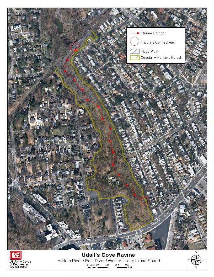
54 CRP SITE 11. UDALLS COVE RAVINE A. HARBOR ESTUARY PROGRAM SITE INFORMATION Category: Existing restoration, preservation, and/or mitigation site. Location: Headwaters of Udall s Cove located at Queens/Nassau border, NY; southeastern end of Little Neck Bay. The ravine at Udalls Park Preserve is located south of the Long Island Railroad tracks. It is bounded to southeast by Northern Boulevard at the intersection of 245 th Street, to the northeast by Willow Street, to the southwest by 243 rd Street. Watershed: Long Island Sound Size: ~20 acres Ownership: New York City Department of Parks & Recreation (NYCDP&R), NYS, private. Site Description: The ravine serves as critical wildlife habitat, and as a filter that is crucial to the maintenance and enhancement of water quality in Udalls Cove and Little Neck Bay. The Ravine is a deep gorge with steep sides. The ravine s focal point is Gabler s Creek, which flows north and empties into the cove. Gabler s Creek runs largely underground from the heights of Little Neck Hills, under Northern Boulevard and emerges into the bottom of the Udalls Cove Ravine. Gabler s Creek runs north until it reaches the Long Island Railroad embankment. Near Depew Avenue, the creek spreads out and meanders through a wider flood plain, depositing a typical heavy load of silt and sand. When it reaches the railroad, Gabler s Creek enters a stone-lined channel built by the Civilian Conservation Corps during the depression era. The channel takes a dogleg east, then north again through a culvert under the railroad. Until recently, the built channel continued straight north, under Sandhill Road (the Back Road ), and on out to join the Cove near Memorial Field. In 2006 the path of the creek was adjusted again. Now, on the north side of the railroad embankment, the channel takes a further 90 turn to the west, and flows into the restored Aurora Pond (more about that below). Near the Pond overlook there is a small weir or dam that maintains the water elevation in the pond. The water flows over the weir, and back into another channel that returns it to its former bed on its way to the Cove. Udalls Cove Preservation Committee, Inc (UCPC), in cooperation with NYCDP&R, has completed several restoration project in the ravine portion of the Udalls Cove Park and Nature Preserve -- (1) construction of a rock-lined drainage swale to control erosion in this area of the Park; (2) replenishment of lost top soil; (3) covering the new soil with wood chips;(4) replanting the area with native species of trees and shrubs; and (5) debris removal. Current Land Use: Wildlife preserve. Active/ passive recreation. Available Habitat: Forest tidal shallows and salt marsh up to the level of mean high tide, and adjoining undeveloped uplands areas. Mixed woodland, degraded salt marsh, dominated by Phragmites. Gabler s Creek hosts populations of American eel (Anguilla rostrata) that live there until maturity, when they return to the Atlantic Ocean to spawn. The forest that surrounds the ravine is host to various forms of plant life, primarily box elder (Acer negundo), which prefers the moist soil on the banks of the creek. Other species include black willow (Salix nigra), silver maple (Acer saccharinum), hickory (Carya), and tree-of-heaven (Ailanthus altissima). Several vine species are present as well, such as wild grape (Vitis), porcelain berry (Ampelopsis brevipedunculata), Japanese hops (Humulus japonicus), and kudzu (Pueraria lobata), which wind up tree trunks and throughout upper branches.
55 Proposed Project: Projected/Estimated Costs: Project Status: Much of the area has been acquired by New York State and City, and the Village of Great Neck Estates, and is now protected as the Udalls Cove Park and Preserve. Partners: Udalls Cove Preservation Committee, Inc. (UCPC) Project Contact: Gloria Bodie, Executive Director Phone: (718) Website: Project Funding Source: NYCDP&R HEP Ratification Date: 12/11/1997 B. HUDSON RARITAN ESTUARY ECOSYSTEM RESTORATION STUDY INFORMATION Restoration Recommendations (Applicable Target Ecosystem Characteristics): Coastal and Maritime Forests Support to ongoing floodplain forest may include removal of invasive spp. forest restoration and stormwater capture projects in and replanting with natives. ~14.35 acres of the Ravine portion of the park. Sediment Contamination - Potential dredging and Tributary Connections - Improve stream conditions capping of contaminated sediment based on testing. and hydrodynamics along ~2,522 feet of tidally Public Access - Support enhancements to existing restricted areas may include assessing culverts and public access paths. portions of the Gabler s Creek for daylighting. Restoration of ~2.55 acres of the Depew Avenue Benefits, Cost and Comparative Restoration Ratio: C. EXISTING SITE SPECIFIC DATA INVENTORY A. Survey, Maps and GIS: B. Site History and Land Use: UCPP website C. Biological Studies/ Fauna: D. Biological Studies/ General Environment: UCPP website E. Geotechnical: UCPP website F. Hydraulics and Hydrology: G. Water and Sediment: H. Historical and Cultural Resources: UCPP website I. Restoration Remediation and Design Plans: *Work in progress REFERENCES: USACE Restoration Opportunities in the Hudson-Raritan Estuary. U.S. Army Corps of Engineers, New York District, New York, NY. USACE Hudson-Raritan Estuary Environmental Restoration Feasibility Study; Harlem River/East River/Western Long Island Sound Study Area Report. The Udall s Cove Preserve Committee (UCPP)- NYC Parks- NYS DEC-
56 LISS-
57
58
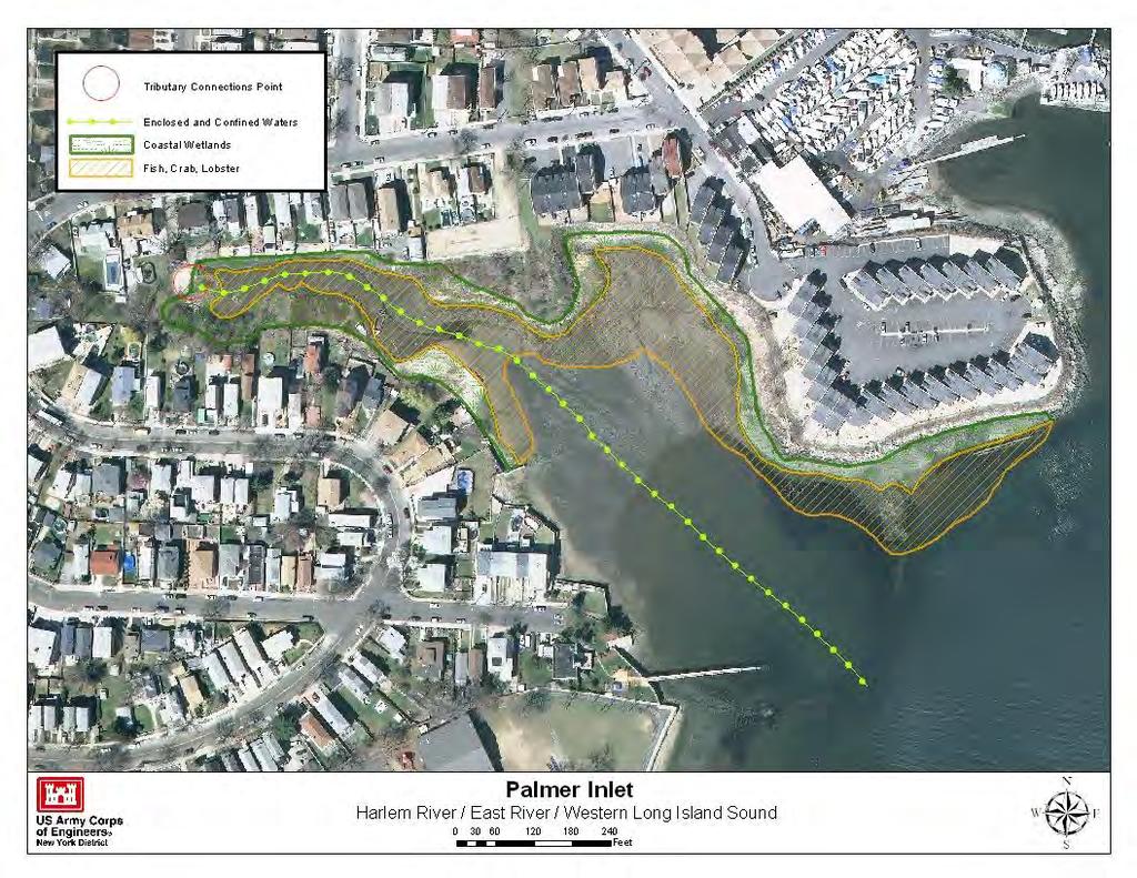
59 CRP SITE 153. PALMER INLET A. HARBOR ESTUARY PROGRAM SITE INFORMATION Category: Existing restoration, preservation, and/or mitigation site. Location: This inlet is located less than one-half mile south of the Pelham Bay Landfill in Eastchester Bay, Bronx, NY. Watershed: Long Island Sound. Size: Ownership: Private, Site Description: Site contains fringe marsh, intact Indian Fishing Weir and several types of natural communities, such as mud flats, sandy and rocky. Since the loss of the brook, Palmer Inlet has rapidly been filling with sediment. Most of the Inlet is surrounded by private residences. Since the loss of the brook, Palmer Inlet has rapidly been filling with sediment. While some local residents favor the idea of dredging, the Fishermen believe that the benefits of dredging will be short lived absent the restoration of effective flushing. Current Land Use: Residential, Available Habitat: Wetland Proposed Project: Salt marsh/riparian restoration. Projected/Estimated Costs: Project Status: Partners: Project Contact: HEP Phone: (212) Website: Project Funding Source: HEP Ratification Date: 12/11/1997
60 B. HUDSON RARITAN ESTUARY ECOSYSTEM RESTORATION STUDY INFORMATION Restoration Recommendations (Applicable Target Ecosystem Characteristics): Coastal Wetlands Removal of phragmites and wrecks and old concrete pier coupled with brook encroaching lawns, replanting with spartina and restoration along ~1,288 feet will restore flow. regarding to proper wetland elevations along ~1.7 acres. Sediment Contamination - Potential dredging and Tributary Connections - Restore the continuous capping of contaminated sediment based on testing. flushing by restoring connection to the brook that was diverted in Enclosed and Confined Waters Dredging the inlet of silt buildup and removal or cutting up of abandoned Benefits, Cost and Comparative Restoration Ratio: C. EXISTING SITE SPECIFIC DATA INVENTORY A. Survey, Maps and GIS: B. Site History and Land Use: C. Biological Studies/ Fauna: D. Biological Studies/ General Environment: E. Geotechnical: F. Hydraulics and Hydrology: G. Water and Sediment: H. Historical and Cultural Resources: Site contains intact Native American fishing weir. I. Restoration Remediation and Design Plans: *Work in progress REFERENCES: NYS DEC Restoration of Natural Resources through the Jamaica Bay Damages Account 2007 Update. NYS DEC Restoration of Natural Resources through the Jamaica Bay Damages Account 2007 Update. USACE Hudson-Raritan Estuary Environmental Restoration Feasibility Study; Harlem River/East River/Western Long Island Sound Study Area Report.
61
62 CRP SITE 650. HART ISLAND A. HARBOR ESTUARY PROGRAM SITE INFORMATION Category: Existing restoration, preservation, and/or mitigation site. Location: Western Long Island Sound northeast of City Island, Bronx, NY. Watershed: Long Island Sound Size: 120 acres Ownership: NYC Site Description: Hart Island is inaccessible to the public. It has been, at times, a workhouse, a hospital, several prisons, a Civil War internment camp (1865), a reformatory, a drug rehabilitation facility ( ), Nike Ajax and Hercules surface to air missiles ( ), and a small sewage treatment plant (STP) that treated about 1 million of gallons of wastewater per day. The Island is still a great fishing spot for fluke, bluefish, porgy, and striped bass. The shore habitats, as well as the wooded bluffs, give bird watchers an unlimited source of pleasure. The Island is also a potential breeding ground for mosquitoes and a source of floatables. The east and north shores have many derelict vessels and potential floatable debris that can be re-suspended during extreme tides and storms. The many buildings are now in disrepai Current Land Use: NYC potters island. Available Habitat: Proposed Project: Salt marsh, dune, beach restoration; enhance shorebird nesting habitat; shoreline softening/stabilization; upland meadow restoration. Projected/Estimated Costs: Project Status: Partners: USACE Project Contact: Phone: Website: Project Funding Source: HEP Ratification Date:
63 B. HUDSON RARITAN ESTUARY ECOSYSTEM RESTORATION STUDY INFORMATION Restoration Recommendations (Applicable Target Ecosystem Characteristics): Islands for Waterbirds Restore foraging and nesting Coastal and Maritime Forests Assessment and grounds for waterbirds through the following habitat potential restoration to ~7.23 acres of bluffs and dunes to restoration activities. include addition of vegetation and potential re-grading. Coastal Wetlands- Creation/restoration of ~4.67 acres Shorelines and Shallows Extensive debris removal of saltmarsh habitat. Assessment of invasives, elevations along ~12,911 feet of shoreline with riparian plantings and hydrology with potential for native plantings and regrading. (contingent on cemetery locations) to create more where appropriate. Assess potential and need to re-grade naturally sloping shorelines and intertidal habitat. Benefits, Cost and Comparative Restoration Ratio: C. EXISTING SITE SPECIFIC DATA INVENTORY A. Survey, Maps and GIS: B. Site History and Land Use: C. Biological Studies/ Fauna: D. Biological Studies/ General Environment: E. Geotechnical: F. Hydraulics and Hydrology: G. Water and Sediment: H. Historical and Cultural Resources: I. Restoration Remediation and Design Plans: *Work in progress REFERENCES: Captain Pete Sattler for Long Island Sound Study. Summer Sound Update: Newsletter of the Long Island Sound Study, Island Issue. USACE Restoration Opportunities in the Hudson-Raritan Estuary. U.S. Army Corps of Engineers, New York District, New York, NY. USACE Hudson-Raritan Estuary Environmental Restoration Feasibility Study; Harlem River/East River/Western Long Island Sound Study Area Report.
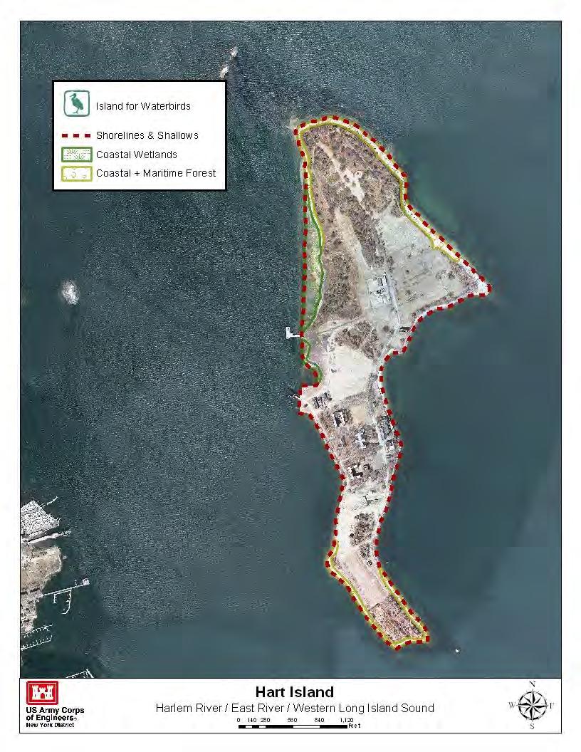
64
65 CRP SITE 12. HUCKLEBERRY ISLAND A. HARBOR ESTUARY PROGRAM SITE INFORMATION Category: Existing restoration, preservation, and/or mitigation site. Location: Huckleberry Island is located in western Long Island Sound, approximately three-fourths of one mile east of Davids Island, in the City of New Rochelle, Westchester County. Watershed: Long Island Sound. Size: 10 acres Ownership: Huckleberry Indians, Inc., a club within the New York Athletic Club. Site Description: Huckleberry Island provides an undisturbed upland environment for wildlife that is rare in coastal portions of the New York metropolitan area. Protected by New York State as a critical wildlife habitat, the primary significance of the island is its use for nesting by colonial waterbirds such as egrets and night herons and cormorants. The rocky shoreline of Huckleberry Island supports a marine rocky intertidal community comprising one of the most southerly occurrences of this community type on the North Atlantic Coastline. Huckleberry Island is only used during the summer season and development has been limited to a dock and a few small buildings at the western end. Recent surveys (2011) indicate a continuation in declining trends over the past decade for wading and nesting activity on Huckleberry Island. Continued monitoring of this colony is imperative. Current Land Use: Privately owned wildlife preserve. Available Habitat: Bird habitat, colonial wading bird rookery. The fish and wildlife habitat is the undeveloped portion of this rocky, wooded island, comprising approximately 10 acres. The habitat consists of rocky shoreline and mostly deciduous forest with virtually no shrubs or herbaceous growth under the canopy. Proposed Project: Projected/Estimated Costs: Project Status: Partners: New York City Audubon and NYCDPR. Project Contact: Phone: Website: Project Funding Source: HEP Ratification Date: 3/4/ 1999
66 B. HUDSON RARITAN ESTUARY ECOSYSTEM RESTORATION STUDY INFORMATION Restoration Recommendations (Applicable Target Ecosystem Characteristics): Islands for Waterbirds Assessment of breeding and foraging habitat. Eradication of predators and control of unauthorized human traffic during breeding season. Benefits, Cost and Comparative Restoration Ratio: C. EXISTING SITE SPECIFIC DATA INVENTORY A. Survey, Maps and GIS: B. Site History and Land Use: C. Biological Studies/ Fauna: D. Biological Studies/ General Environment: E. Geotechnical: F. Hydraulics and Hydrology: G. Water and Sediment: H. Historical and Cultural Resources: I. Restoration Remediation and Design Plans: *Work in progress REFERENCES: Craig, E New York City Audubon s Harbor Herons Project: 2011 Interim Nesting Survey Report. New York City Audubon, New York, NY. Künstler, D. 2007b. The colonial waterbirds of Huckleberry Island, New Rochelle, Westchester County, New York (2007). NYC Department of Parks and Recreation report. NYS DOSwww.nyswaterfronts.com/downloads/.../LongIsland/Huckleberry_Island.pdf NAS-
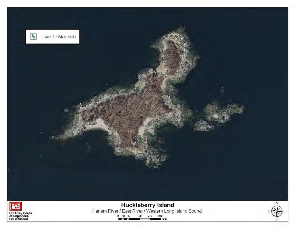
67
68 CRP SITE 52. CITY ISLAND WETLANDS A. HARBOR ESTUARY PROGRAM SITE INFORMATION Category: Existing restoration, preservation, and/or mitigation site. Location: Between Tier and Ditmar Streets, City Island, Bronx, NY. Watershed: Long Island Sound Size: ~3 acres. Ownership: NYCDPR Site Description: This fresh water creek and degraded salt marsh comprise the island's last natural wetland and are now further threatened by the burgeoning of surrounding development. Most of the land is partially underwater, and the tract contains both low and high marsh areas (Spartina alterniflora and Spartina patens), mud flats, and giant reeds (Phragmites communis). The Department of Citywide Administrative Services assigned the property to Parks in Current Land Use: Wetland. Available Habitat: Wetland fringe, and woodland buffer, disturbed upland buffer with a healthy salt marsh fringe. Proposed Project: Projected/Estimated Costs: $2,000,000 Project Status: Partners: Project Contact: Paul Mankiewicz, Gaia Institute Phone: Website: info@gaiainstituteny.org. Project Funding Source: HEP Ratification Date: 12/11/1997
69 B. HUDSON RARITAN ESTUARY ECOSYSTEM RESTORATION STUDY INFORMATION Restoration Recommendations (Applicable Target Ecosystem Characteristics): Coastal Wetlands Preservation/restoration of the addition of complex structure along approximately ~1.37 ~1.46 acre Ditmar St. saltmarsh to include regarding, acres of mudflats surrounding the wetland. removal of invasives and re-planting with natives. Tributary Connections Restore hydrologic Coastal and Maritime Forests connection with the freshwater creek running through Preservation/restoration of ~3.78 acres of upland the site through culvert assessment, daylighting and/or wooded buffer. stream corridor restoration along ~534 feet of the creek. Habitat for Fish, Crab and Lobsters Assess flats for Sediment Contamination - Potential dredging and composition, level of degradation and potential capping of contaminated sediment based on testing. enhancements to increase habitat connectivity- such as Benefits, Cost and Comparative Restoration Ratio: C. EXISTING SITE SPECIFIC DATA INVENTORY A. Survey, Maps and GIS: B. Site History and Land Use: C. Biological Studies/ Fauna: D. Biological Studies/ General Environment: E. Geotechnical: F. Hydraulics and Hydrology: G. Water and Sediment: H. Historical and Cultural Resources: I. Restoration Remediation and Design Plans: *Work in progress REFERENCES: NYC Parks- USACE Hudson-Raritan Estuary Environmental Restoration Feasibility Study; Harlem River/East River/Western Long Island Sound Study Area Report.
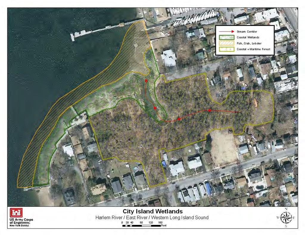
70

71 CRP SITE 177. TURTLE COVE A. HARBOR ESTUARY PROGRAM SITE INFORMATION Category: Existing restoration, preservation, and/or mitigation site. Location: Pelham Bay Park, Bronx NY Watershed: Long Island Sound Size: 29 acres, 80 acres. Ownership: NYCDPR Site Description: A diverse salt marsh/mudflat/rocky intertidal habitat complex, the site supports a wide variety of fish and avian species. Turtle Cove has been separated hydrologically from the Lagoon by old roads to City Island. Turtle Cove marsh and natural areas of Pelham Bay Park was part of a major restoration project that began in June Activities included clearing and removal of the woody debris in preparation for the renovation and for new trees. A new bridge was installed to replace the berm that has separated the two watery areas of the marsh. The original berm once had culverts to allow the water to flow in and out but over the years, the openings filled in and divided the coves. The increased tidal flow will provide for more saltwater wetland habitat. The new bridge will be able to accommodate visitors on foot and bicycle, who can then continue across Park Drive into the Meadow at the south end of Orchard Beach. Spartina grass was planted in areas that will receive the increased tidal flushing. Additionally, as part of the Million Trees NYC project, about 2,350 trees were be planted this fall, with an eventual total of 10,000 trees in the Turtle Cove area. Funding was provided from a National Fish & Wildlife Foundation grant, efforts were undertaken by the New York State Department of Environmental Conservation (DEC). More recently (2010) an 11 acres forest restoration was initiated along Orchard Beach Road and the rear fence of the driving range. The area was overrun with invasive plants including Porcelainberry, Mile-A-Minute, and Oriental Bittersweet and will be planted with native species such as oak, white oak, pin oak, tulip poplar, sweeetgum, black birch, hackberry, and white pine. Current Land Use: Active and passive recreation. Available Habitat: Wetland Proposed Project: Salt marsh restoration, restoration of tidal flow to diked area, restoration of native species to Phragmites dominated area. Projected/Estimated Costs: Project Status: Construction completed in Additional site restoration is ongoing and TBD by NYC DPR. Partners: NYSDEC, NYCDPR, NYCDOT, MTA, Pelham Bay Park. Project Contact: Michael Feller, NYC Parks/NRG Phone: (212) Website: Project Funding Source: Jamaica Bay Damages Fund
72 HEP Ratification Date: 12/11/1997 B. HUDSON RARITAN ESTUARY ECOSYSTEM RESTORATION STUDY INFORMATION- TBD Restoration Recommendations (Applicable Target Ecosystem Characteristics): Coastal Wetlands - Habitat for Fish, Crab and Lobsters - Islands for Waterbirds - Tributary Connections - Coastal and Maritime Forests - Enclosed and Confined Waters Oyster Reefs - Sediment Contamination - Eelgrass Beds - Public Access - Shorelines and Shallows - Benefits, Cost and Comparative Restoration Ratio: C. EXISTING SITE SPECIFIC DATA INVENTORY A. Survey, Maps and GIS: B. Site History and Land Use: C. Biological Studies/ Fauna: D. Biological Studies/ General Environment: E. Geotechnical: F. Hydraulics and Hydrology: G. Water and Sediment: H. Historical and Cultural Resources: I. Restoration Remediation and Design Plans: *Work in progress REFERENCES: USACE Restoration Opportunities in the Hudson-Raritan Estuary. U.S. Army Corps of Engineers, New York District, New York, NY. NY/NJ Harbor Estuary Program- New York State Department of Environmental Conservation Restoration of Natural Resources through the Jamaica Bay Damages Account 2007 Update. USACE Hudson-Raritan Estuary Environmental Restoration Feasibility Study; Harlem River/East River/Western Long Island Sound Study Area Report. Alderson, Carl and Justin Bowers Reaching for the Past in Pursuit of the future: how can our present and past efforts inform the Hudson-Raritan Estuary Comprehensive Restoration Plan and the direction of habitat restoration going forward. A project for the New York-New Jersey Harbor & Estuary Program and New England Interstate Water Pollution Control Commission. *TBD

73 CRP SITE 179. PELHAM BAY PARK/TALLAPOOSA WEST A. HARBOR ESTUARY PROGRAM SITE INFORMATION Category: Existing restoration, preservation, and/or mitigation site. Location: West bank of the Hutchinson River at the head of Eastchester Bay. Site is bounded by Pelham Bay landfill to the south and Amtracks Northeast Corridor railroad to the north. Watershed: Long Island Sound Size: 35 acres Ownership: NYCDPR Site Description: Pelham Bay Park is the largest natural area complex within the region. The park has a wide range of habitats, including forests (782 acres), meadows (83 acres), mixed scrub (51 acres), salt marsh (195 acres), fresh water marsh (three acres), salt flats (161 acres), and a stretch of saltwater coastline. Formerly a horse stable, drainage patterns at Tallapoosa west have been altered from road and rail line construction in the area. The City began landfill operations near Tallapoosa Point in Pelham Bay Park in The site is currently designated wildlife refuge. Current Land Use: Marsh, active/passive recreation. Available Habitat: Part of the Thomas Pell Wildlife Refuge and Sanctuary. Site contains upland, forest, scrub/shrub, open fields/lawns; Estuarine - marshes, tidal waterways, intertidal flats, estuarine. Proposed Project: Shoreline softening, wetland enhancement, invasive species removal. The banks of the drainage ditch could be softened via regrading and planting with native salt marsh species (e.g. Spartina spp.). Additional tidal channels could be excavated in the adjacent uplands and the banks planted with native vegetation. An existing freshwater pond at the head of the drainage ditch could be enlarged to accommodate additional freshwater seep flow, reducing flow rates into the drainage ditch during periods of high runoff. Projected/Estimated Costs: $600,000 Project Status: Jamaica Bay Damage Account funds ($85,000) will provide local match for 1996 Clean Water/Clean Air Bond Act funds ($324,825) to restore tidal wetlands at Tallapoosa West in Pelham Bay Park, Bronx County. The project will be designed to improve stormwater filtering capacity of Tallapoosa West through Phragmites removal, regrading, wetland and upland plantings, and excavation of tidal channels. NYCDPR preliminary plans in conjunction with NYSDEC to restore tidal flow to 4.3 acres of filled marsh is completed. Partners: NYCDPR, NYSDOS, HEP, EPA, NYSDEC Project Contact: Marit Larson NYC DPR, Susan Bauer-Maresca NYS DEC Phone: Website: Project Funding Source: NYSCWCA HEP Ratification Date:
74 B. HUDSON RARITAN ESTUARY ECOSYSTEM RESTORATION STUDY INFORMATION- TBD Restoration Recommendations (Applicable Target Ecosystem Characteristics): Coastal Wetlands - Habitat for Fish, Crab and Lobsters - Islands for Waterbirds - Tributary Connections - Coastal and Maritime Forests - Enclosed and Confined Waters - Oyster Reefs - Sediment Contamination - Eelgrass Beds - Public Access - Shorelines and Shallows Benefits, Cost and Comparative Restoration Ratio: C. EXISTING SITE SPECIFIC DATA INVENTORY A. Survey, Maps and GIS: B. Site History and Land Use: C. Biological Studies/ Fauna: D. Biological Studies/ General Environment: E. Geotechnical: F. Hydraulics and Hydrology: G. Water and Sediment: H. Historical and Cultural Resources: I. Restoration Remediation and Design Plans: *Work in progress REFERENCES: USACE Restoration Opportunities in the Hudson-Raritan Estuary. U.S. Army Corps of Engineers, New York District, New York, NY. New York State Department of Environmental Conservation Restoration of Natural Resources through the Jamaica Bay Damages Account 2007 Update. NY Audubon Site Report: USACE Hudson-Raritan Estuary Environmental Restoration Feasibility Study; Harlem River/East River/Western Long Island Sound Study Area Report. Alderson, Carl and Justin Bowers Reaching for the Past in Pursuit of the future: how can our present and past efforts inform the Hudson-Raritan Estuary Comprehensive Restoration Plan and the direction of habitat restoration going forward. A project for the New York-New Jersey Harbor & Estuary Program and New England Interstate Water Pollution Control Commission. *TBD- Construction completed.
 Nature Study Woods is adjacent to twin lakes. Access is on Webster Avenue and Glenorchy Road, New Rochelle, NY.")
75 CRP SITE 678. HUTCHINSON RIVER MARSH RESTORATION A. HARBOR ESTUARY PROGRAM SITE INFORMATION Category: Existing restoration, preservation, and/or mitigation site. Location: a) Nature Study Woods is adjacent to twin lakes. Access is on Webster Avenue and Glenorchy Road, New Rochelle, NY. b) Thomas Pell Wildlife Sanctuary marsh is located on the east bank of the Hutchinson River. The northern border of the marsh is located south of the intersection of the Hutchinson River Parkway and I-95. Watershed: Hutchinson River Size: a) 2.5 acres b) ~200 acres Ownership: NYC, NYCDPR, private. Site Description: Thomas Pell Sanctuary is the second largest salt marsh habitat in New York City. The salt marsh suffers from strong erosion forces and degradation caused by urbanization and altered hydrology. The area is home to a variety of wildlife including raccoon, egrets, hawks, and coyotes. a) Nature Study Woods lies to the south and is comprised of woods covered below with Garlic Mustard and wetlands covered with acres of Skunk Cabbage. A few foot trails break off the single main trail. b) Thomas Pell Wildlife Sanctuary Marsh. This area is bisected by the Hutchinson River Parkway and is composed of Goose Creek marsh (to the east of the pkwy) and the Hutchinson River Marsh (west of the pkwy). Current Land Use: Mixed use open space, industrial, private. Available Habitat: This site is mostly estuarine marshland and tidal waterways. Waterfowl foraging areas, freshwater marshes and woody swamps, upland and riparian forests, tidal wetlands, and intertidal mudflats. Proposed Project: a) Nature Study Woods in New Rochelle. b) Thomas Pell Wildlife Sanctuary marsh; shoreline stabilization and salt marsh fringe restoration. Creation of upland vegetation buffer. Projected/Estimated Costs: Project Status: a) Construction complete. Nature Study Woods in New Rochelle has undergone invasive species removal (Polygonum cuspidatun, Ampelopsis brevipedunculata, Euonymus alatus) through out the park system. Invasive were replaced by native groundcovers, shrubs and trees. Part of a large stormwater pipe in the park was removed and an erosion resistant, stone-lined pad was installed at the end of the pipe. A portion of the freshwater wetland damaged by stormwater gushing from the pipe was restored. Work was completed in the fall of 2004 as part of the Long Island Sound Study. b) Larger marsh restoration work remains unchanged. Partners: NRDC Project Contact: Phone: Website:
76 Project Funding Source: HEP Ratification Date: B. HUDSON RARITAN ESTUARY ECOSYSTEM RESTORATION STUDY INFORMATION Restoration Recommendations (Applicable Target Ecosystem Characteristics): Coastal Wetlands Assessment of ~ acres of wetlands for invasive species, hydrology, erosion, debris and proper elevations. Habitat for Fish Crab and Lobsters- Assess flats for composition, level of degradation and potential enhancements to increase habitat connectivity- such as addition of complex structure along approximately ~68.28 acres surrounding the marsh will facilitate connections and movements between habitats. Coastal and Maritime Forests Creation of ~ acres of upland buffer along the Thomas Pell Sanctuary marsh may include re-grading and native vegetation plantings. Tributary Connections- Assessment of culverts and road crossings to restore tidal exchange across ~3,145 feet blocked by the Hutchinson River Parkway. Public Access Several opportunities exist for trails, canoe launches and improvements to existing wildlife sanctuaries. Sediment Contamination - Potential dredging and capping of contaminated sediment based on testing. Benefits, Cost and Comparative Restoration Ratio: C. EXISTING SITE SPECIFIC DATA INVENTORY A. Survey, Maps and GIS: Regional data exists inclusive of this site. B. Site History and Land Use: No data obtained C. Biological Studies/ Fauna: Freshwater Invertebrate and biological assessment (Bode R.W. et al. 2000) D. Biological Studies/ General Environment: Qualitative description of habitat (USACE 2000, Rae G.E. 2009). Part of Long Island Sound Watershed Program. E. Geotechnical: No data obtained F. Hydraulics and Hydrology: Flood risk assessment (USACE 2008) G. Water and Sediment: Water Quality Assessment (Bode R.W. et al. 2000). H. Historical and Cultural Resources: No data obtained I. Restoration Remediation and Design Plans: No data obtained References: USACE New York District Expedited Reconnaissance Study: Section 905(b) (WRDA 86) Preliminary Anlaysis, Hudson Raritan Estuary Environmental Restoration, US Army Corps of Engineers, New York District, New York, NY. CT DEP Office of Long Island Sound Programs Long Island Sound Study Habitat Restoration Initiative Annual Summary for the year CT DEP Office of Long Island Sound Programs Long Island Sound Study Habitat Restoration Initiative Annual Summary for the year 2004, Technical Support for Coastal Habitat Restoration USACE New York District Hudson Raritan Estuary Environmental Restoration Feasability Study Harlem River/East River/Western Long Island Sound Study Area Report. Rae, G.E Hutchinson river restoration project. Bode R.W. et al Biological stream assessment, Hutchinson River, Westchester County, New York. Stream Biomonitoring Unit, Bureau of Watershed Assessment and Research, Division of Water, NYS DEC. USACE New York District SECTION 905(B) RECONNAISSANCE STUDY Westchester County Streams, Westchester County, NY and Fairfield County, CT.

77 Alderson, Carl and Justin Bowers Reaching for the Past in Pursuit of the future: how can our present and past efforts inform the Hudson-Raritan Estuary Comprehensive Restoration Plan and the direction of habitat restoration going forward. A project for the New York-New Jersey Harbor & Estuary Program and New England Interstate Water Pollution Control Commission. Westchester County-
78 CRP SITE 679. HUTCHINSON RIVER FISH IMPEDIMENT REMOVAL A. HARBOR ESTUARY PROGRAM SITE INFORMATION Category: Existing restoration, preservation, and/or mitigation site. Location: The Hutchinson River begins in a swampy area that serves as the dividing line between New Rochelle and Eastchester, it flows 5 miles south through Westchester County, the mainland Bronx, past City Island, ending in Eastchester Bay in Long Island Sound. Hutchinson River fish impediment removal Lower Hutchinson River near the Westchester/Bronx border. Watershed: Hutchinson River Size: N/A Ownership: NYC, NYCDPR, private. Site Description: The Hutchinson River was dammed by the New Rochelle Water Company in 1886 and 1907 to create three reservoirs at the northern end of the community. The reservoirs and the surrounding water shed property was purchased by the Westchester County Park Commission in 1927 for parkland and parkway purposes. Additionally there is an impediment south of the 3 reservoirs at Pelham Lake. Fish passage, including historic Alewife runs, has been eradicated by these structures. Current Land Use: Mixed use open space, industrial, private. Available Habitat: This site is mostly estuarine marshland and tidal waterways. Waterfowl foraging areas, freshwater marshes and woody swamps, upland and riparian forests, tidal wetlands, and intertidal mudflats. Proposed Project: Projected/Estimated Costs: Project Status: Fish impediment work remain unchanged. Partners: NRDC Project Contact: Phone: Website: Project Funding Source: HEP Ratification Date:
79 B. HUDSON RARITAN ESTUARY ECOSYSTEM RESTORATION STUDY INFORMATION Restoration Recommendations (Applicable Target Ecosystem Characteristics): Tributary Connections Anadromous fish passage would be restored through the removal of passage impediments, such as the weir/dam structures, or through the creation of fish passage structures, such as fish ladders. Benefits, Cost and Comparative Restoration Ratio: C. EXISTING SITE SPECIFIC DATA INVENTORY A. Survey, Maps and GIS: Regional data exists inclusive of this site. B. Site History and Land Use: No data obtained C. Biological Studies/ Fauna: Freshwater Invertebrate and biological assessment (Bode R.W. et al. 2000) D. Biological Studies/ General Environment: Qualitative description of habitat (USACE 2000, Rae G.E. 2009). Part of Long Island Sound Watershed Program. F. Hydraulics and Hydrology: Flood risk assessment (USACE 2008) G. Water and Sediment: Water Quality Assessment (Bode R.W. et al. 2000). H. Historical and Cultural Resources: No data obtained I. Restoration Remediation and Design Plans: No data obtained E. Geotechnical: No data obtained References: USACE New York District Expedited Reconnaissance Study: Section 905(b) (WRDA 86) Preliminary Anlaysis, Hudson Raritan Estuary Environmental Restoration, US Army Corps of Engineers, New York District, New York, NY. CT DEP Office of Long Island Sound Programs Long Island Sound Study Habitat Restoration Initiative Annual Summary for the year CT DEP Office of Long Island Sound Programs Long Island Sound Study Habitat Restoration Initiative Annual Summary for the year 2004, Technical Support for Coastal Habitat Restoration USACE New York District Hudson Raritan Estuary Environmental Restoration Feasability Study Harlem River/East River/Western Long Island Sound Study Area Report. Rae, G.E Hutchinson river restoration project. Bode R.W. et al Biological stream assessment, Hutchinson River, Westchester County, New York. Stream Biomonitoring Unit, Bureau of Watershed Assessment and Research, Division of Water, NYS DEC. USACE New York District SECTION 905(B) RECONNAISSANCE STUDY Westchester County Streams, Westchester County, NY and Fairfield County, CT.
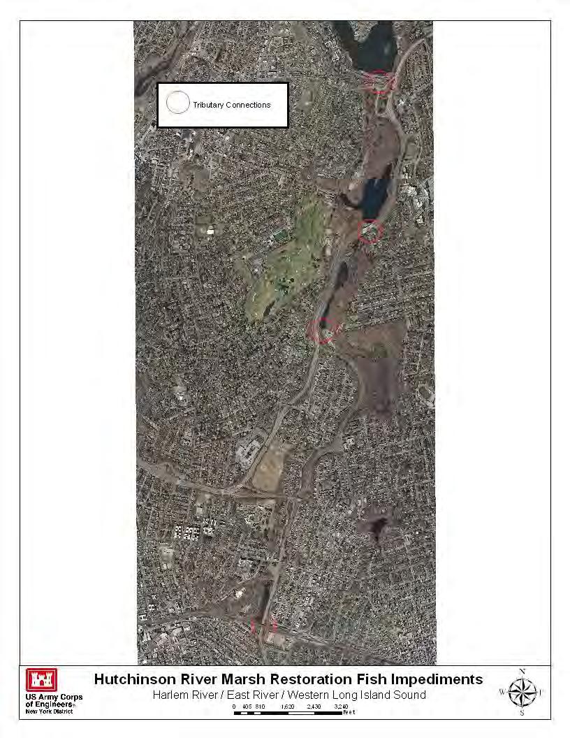
80

81 CRP SITE 652. RICE STADIUM WETLANDS (WATT AVENUE WETLANDS) A. HARBOR ESTUARY PROGRAM SITE INFORMATION Category: Existing restoration, preservation, and/or mitigation site. Location: Northeast section of Eastchester Bay at Watt Avenue, Bronx NY. Watershed: Long Island Sound Size: 10 acres Ownership: NY City Site Description: Part of Pelham Bay Park, this site is characterized by degraded salt marsh which is dominated by Phragmites. Current Land Use: Available Habitat: Coastal wetlands Proposed Project: Excavate Phragmites, regrade to appropriate intertidal elevation, plant Spartina spp. Projected/Estimated Costs: Project Status: Soundkeeper, in cooperation with the New York Coastal Fishermen's Association and the New York City Department of Parks and Recreation, recently completed construction of a one half acre low marsh/high marsh/brackish marsh ecosystem at the southern boundary of Pelham Bay Park, Bronx, NY. The marsh is unusual in that it contains three distinct marsh zones within such a small area. It is also important because it lies adjacent to a highly urbanized neighborhood that has been cut off from the waterfront except for the access through this marsh to Pelham Bay Park. Construction completed in Freshwater Marsh dominated by Phragmites- occupies up to 40% of the entire marsh. The primary freshwater source is rainwater with some groundwater flow into the site from adjacent parkland. There are no active discharge pipes from storm drains entering the area. Brackish Marsh- area is a small depression usually saturated with water draining from the upland section of the marsh. It is inundated with salt water during major storms that coincide with high tide. It occupies less than 5% of the entire marsh. Highmarsh with Phragmites- area represents approximately 10% of the marsh. The phragmites is stunted (average 4 ft) due to monthly tidal flooding. The excavated saltwater channel will border this area. High Marsh- area represents approximately 15% of the entire marsh. It is subject to heavy foot traffic from fishermen. Low Marsh- area represents approximately 15% to 20% of the entire marsh. The only plant species is Spartina alterniflora (food producer). The major mollusc species is the ribbed mussel (Geukensia demissa). There are numerous Atlantic Marsh fiddler crab (Uca pugnax) burrows located at the very narrow lowmarsh/high marsh border. This area will remain undisturbed during the excavation of the channel. Partners: Long Island Soundkeeper, New York Coastal Fisherman's Association, NYCDEP, NYSDEC (under Long Island Sound Study LISS), NYC DPR, Hudson River Foundation. Project Contact: Phone:
82 Website: Project Funding Source: HEP Ratification Date: B. HUDSON RARITAN ESTUARY ECOSYSTEM RESTORATION STUDY INFORMATION- TBD Restoration Recommendations (Applicable Target Ecosystem Characteristics): Coastal Wetlands - Habitat for Fish, Crab and Lobsters - Islands for Waterbirds - Tributary Connections - Coastal and Maritime Forests - Enclosed and Confined Waters - Oyster Reefs - Sediment Contamination - Eelgrass Beds - Public Access - Shorelines and Shallows - Benefits, Cost and Comparative Restoration Ratio: C. EXISTING SITE SPECIFIC DATA INVENTORY A. Survey, Maps and GIS: B. Site History and Land Use: C. Biological Studies/ Fauna: D. Biological Studies/ General Environment: E. Geotechnical: F. Hydraulics and Hydrology: G. Water and Sediment: H. Historical and Cultural Resources: I. Restoration Remediation and Design Plans: *Work in progress REFERENCES: USACE Restoration Opportunities in the Hudson-Raritan Estuary. U.S. Army Corps of Engineers, New York District, New York, NY. USACE Hudson-Raritan Estuary Environmental Restoration Feasibility Study; Harlem River/East River/Western Long Island Sound Study Area Report. Soundkeeper- Alderson, Carl and Justin Bowers Reaching for the Past in Pursuit of the future: how can our present and past efforts inform the Hudson-Raritan Estuary Comprehensive Restoration Plan and the direction of habitat restoration going forward. A project for the New York-New Jersey Harbor & Estuary Program and New England Interstate Water Pollution Control Commission. *TBD. Some construction completed in 2000, further plans?
83 CRP SITE 662. PELHAM BAY LANDFILL A. HARBOR ESTUARY PROGRAM SITE INFORMATION Category: Existing restoration, preservation, and/or mitigation site. Location: The site is bordered by the Shore Road/Pelham Bridge Road to the north and the Eastchester Bay to the east and south. Watershed: Long Island Sound Size: 89 acres Ownership: NYCDPR, maintained by NYC Department of Sanitation Site Description: Formerly tidal wetlands and shallow water habitat, this 81 acre inactive landfill located within Pelham Bay Park has been filled with municipal solid wastes. The Pelham Bay Landfill was opened from 1963 until it was closed in Illegal dumping of toxic waste occurred with a great deal of toxic waste runoff into the Eastchester Bay. Once operated by NYCDOS, responsibility for final closure and remediation was transferred to NYCDEP in The site's 89 acres were covered with soil that had been tested, treated and seeded. Currently, the impermeable cap on the landfill is supporting vegetation. In January 1998, a force main was constructed to pipe leachate from the landfill to the Hunts Point Water Pollution Control Plant for treatment. In cases of heavy rain, the force main uses sonar technology to redirect leachate to 120,000 gallon holding tanks on-site. After flows return to normal, the leachate is pumped back to the force main and the Hunts Point Plant. Current Land Use: Inactive landfill. Available Habitat: Proposed Project: Enhancing existing grass cover with shrubs and trees that are native to the area would provide potential nesting and foraging habitat for a variety of avian species. This effort would complement proposed efforts to restore intertidal wetlands and other aquatic habitats in Pelham Bay. Projected/Estimated Costs: Project Status: Partners: Project Contact: Phone: Website: Project Funding Source: HEP Ratification Date:
84 B. HUDSON RARITAN ESTUARY ECOSYSTEM RESTORATION STUDY INFORMATION Restoration Recommendations (Applicable Target Ecosystem Characteristics): Coastal and Maritime Forests Assess ~91.4 acre site for potential forest, grassland, shrub habitat creation through further plantings of native vegetation. Sediment Contamination - The landfills were capped with an impermeable membrane and covered with treated soil. Ensure monitoring is ongoing. Public Access Once remediation and monitoring is complete, site should be assessed for use as potential parkland. Benefits, Cost and Comparative Restoration Ratio: C. EXISTING SITE SPECIFIC DATA INVENTORY A. Survey, Maps and GIS: B. Site History and Land Use: C. Biological Studies/ Fauna: D. Biological Studies/ General Environment: E. Geotechnical: F. Hydraulics and Hydrology: G. Water and Sediment: H. Historical and Cultural Resources: I. Restoration Remediation and Design Plans: *Work in progress REFERENCES: USACE Restoration Opportunities in the Hudson-Raritan Estuary. U.S. Army Corps of Engineers, New York District, New York, NY. Public Health Assessment: New York State Department of Environmental Conservation Restoration of Natural Resources through the Jamaica Bay Damages Account 2007 Update. USACE Hudson-Raritan Estuary Environmental Restoration Feasibility Study; Harlem River/East River/Western Long Island Sound Study Area Report.
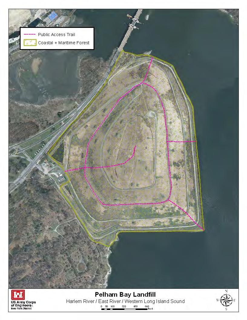
85
86 CRP SITE 669. HEMPSTEAD HARBOR A. HARBOR ESTUARY PROGRAM SITE INFORMATION Category: Existing restoration, preservation, and/or mitigation site. Location: 0.1 miles north northwest from the Intersection of East Broadway and Paper Mill Road, Roslyn, NY. Watershed: Long Island Sound Size: 12 acres Ownership: NYS Site Description: Hempstead Harbor is characterized by a tidal range of approximately 7 8 feet and is designated by NYS Department of State as a Significant Coastal Fish & Wildlife Habitat. This designation is due to its abundant waterfowl population and productivity as a marine finfish nursery and feeding habitat. Various shorebirds also utilize the site during migratory periods and wading birds during the summer months. Historically, Hempstead Harbor supported thriving salt marshes which have deteriorated over the past several decades. The aquatic ecosystem of the study area has experienced degradation as a result of increased urbanization of the surrounding upland areas. The primary contributors to the loss of aquatic and wetland habitats are filling and bulkheading activities surrounding the harbor, increased sediment loading, and nutrient and contaminant runoff from the upland areas into the tributaries of the harbor. Compounding the problem are several pits located on the harbor floor that reduce flushing time. The result is a disproportionate transfer of nutrients and sediments with excess contaminants remaining within the head of the harbor. This in turn exacerbates the frequent occurrence of hypoxia in the summer season, a phenomena common in the western portion of Long Island Sound. These impacts are reflected in the apparent degraded nature of remaining habitats in and surrounding the harbor (e.g., phragmites marsh, benthic and epibenthic communities, etc.) and annual fish kills. Nassau County will seed 2-million shellfish and monitor survival of the seedlings to repopulate Hempstead Harbor with this historically abundant fishery. Before this seeding effort begins, four plots will be created near the main planting sites. The plots will be monitored for rates of survival during the year. The project builds on a prior seeding effort of 1.2 million clams and 500,000 oysters in Hempstead Harbor. Hempstead Harbor has been partially or totally closed to shellfishing since the 1930s as a result of industrial and stormwater pollution. Recent improvements in water quality in the harbor provide some opportunity to restore the beds. Current Land Use: Degraded open water habitat. Available Habitat: Proposed Project: The two primary objectives of the project are to restore the estuarine habitat at the head of the harbor, which has been adversely impacted from urban development surrounding the harbor and to increase tidal flushing rate. Projected/Estimated Costs: $750,000 Project Status: USACE Aquatic Habitat Restoration- An environmental restoration feasibility study is underway. The project was postponed in FY2004 due to a lack of federal funds. The study will resume subject to the availability of funding, at which point the schedule will be reassessed. Bar Beach- A tidal wetland restoration of a 5-acre tidal cove in Hempstead Harbor, bordering the south side of the Town of North Hempstead Bar Beach Park was completed in The project involved removal of approximately 3,150 cu. yards of mixed debris containing primarily asphalt and concrete rubble along the shoreline and a gravel bar peninsula that was covered by common reed (Phragmites australis). The plan included the re-establishment of smooth cordgrass (Spartina alterniflora) in the intertidal zone and high marsh plantings containing salt marsh cordgrass (S. patens),
87 spikegrass (Distichlis spicata) and black grass (Juncus gerardi). The upland adjacent areas where the Phragmites had been removed were seeded to a native warm season grass mixture. In an effort to re-create a true maritime community, a salt shrub zone consisting of marsh elder (Iva frutescens) and groundsel-bush (Baccharis halimifolia) was incorporated into the high marsh and various native shrubs were planted in the upland periphery. Partners: NYSDEC, USACE, Town of North Hempstead. Project Contact: Aleksander Petersen Phone: (917) , aleksander.j.petersen@usace.army.mil Website: Project Funding Source: HEP Ratification Date: B. HUDSON RARITAN ESTUARY ECOSYSTEM RESTORATION STUDY INFORMATION Restoration Recommendations (Applicable Target Ecosystem Characteristics): Coastal Wetlands - Create low tidal marsh habitat, filtration Coastal and Maritime Forests Restoration/preservation of marsh and possible catch basin for storm water outfall at the ~83.7 acres of forested shrub buffer. Assessment for invasives mill which is impacting existing marsh habitat at the south end with potential to expand the area through plantings. of the harbor. Remove riprap and regrade shoreline to create a Habitat for Fish, Crab and Lobsters Addition of complex low tidal marsh on the southwest shore of the harbor. Create structure and enhancements to the mudflats along ~ storm water treatment marsh and possible catch basins on the acres surrounding the wetlands. western shoreline along West Shore Road near Seaview Drive Tributary Connections Assessment of culverts and storm to reduce erosion of remaining marsh and to channel flow into water outfalls for capacity to connect ~2,150 feet of creek. the new marsh. Marsh restoration, totaling ~54.64 acres may Enclosed and Confined Waters - Restore natural bathymetry include debris removal and the addition of clean fill to reach along ~10,944 feet of the harbor to reduce the tidal prism and appropriate wetland elevations. increase harbor flushing rate. Oyster Reefs Support ongoing efforts to re-introduce Sediment Contamination - Potential dredging and capping of shellfish populations to Hempstead Harbor. contaminated sediment based on testing. Benefits, Cost and Comparative Restoration Ratio: C. EXISTING SITE SPECIFIC DATA INVENTORY A. Survey, Maps and GIS: B. Site History and Land Use: C. Biological Studies/ Fauna: D. Biological Studies/ General Environment: E. Geotechnical: F. Hydraulics and Hydrology: G. Water and Sediment:Village of Sea Cliff Hempstead Harbor Water Quality Monitoring Program. H. Historical and Cultural Resources: Roslyn Grist Mill I. Restoration Remediation and Design Plans: *Work in progress REFERENCES: National Oceanic and Atmospheric Administration U.S. Fish and Wildlife Service New York State Department of Environmental Conservation Final Restoration Plan and Environmental Assessment Applied Environmental Services (Shore Realty) Superfund Site. USACE New York District Project Summary Sheet: Hempsted Harbor Protection Committee: EEA Hempstead Harbor wetland restoration:

88 USACE Restoration Opportunities in the Hudson-Raritan Estuary. U.S. Army Corps of Engineers, New York District, New York, NY. USACE Hudson-Raritan Estuary Environmental Restoration Feasibility Study; Harlem River/East River/Western Long Island Sound Study Area Report.
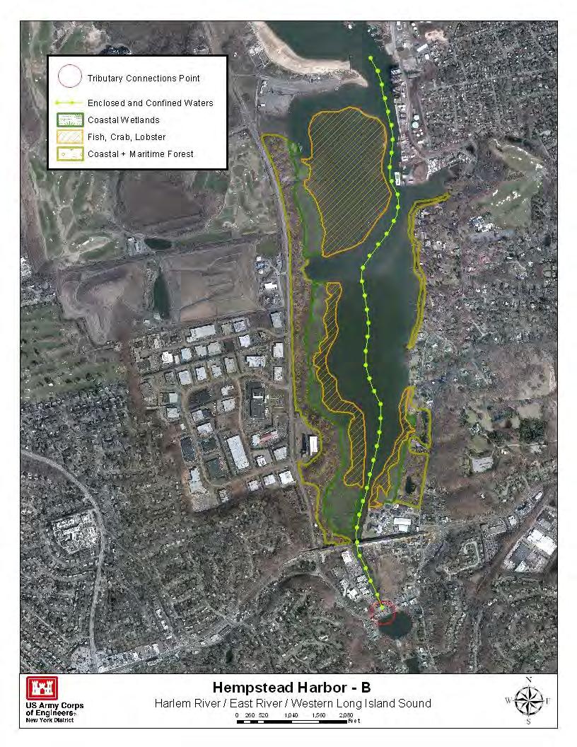
89
Planning for Staten. Habitat Restoration and Green Infrastructure. Island s North Shore
 Habitat Restoration and Green Infrastructure Planning for Staten Island s North Shore Community Board 1 March 1, 2018 NYC Parks Forestry, Horticulture, and Natural Resources Funded by the NYS Department
Restoring Water Ecosystems in NYC Parks
 Restoring Water Ecosystems in NYC Parks Hooked on our Waters Con October 19, 2013 - CUNY Graduate Center Marit Larson NYC Parks Landscape and ecosystem focus Watershed Streams Freshwater wetlands Tidal
Tentatively Selected Plan within Harlem River, East River and Western Long Island Sound Planning Region. First Level Costs. Federal Non-Federal Total
 HARLEM RIVER, EAST RIVER AND WESTERN LONG ISLAND SOUND PLANNING REGION Flushing Bay and Creek Ecosystem Restoration Source Feasibility Study Background Study Resolution (1994), Reconnaissance Report (1996),
New York City, 17 th c.
 Mannahatta New York City, 17 th c. Lower Manhattan, circa 1930s Westside Highway, Manhattan, circa 1940s Greenpoint Terminal Market, Brooklyn VISION 2020 NEW YORK CITY COMPREHENSIVE WATERFRONT PLAN
Baylands Segment J. Bay between the Golden Gate and Segment J. Coyote Point. of For managed ponds. included habitat enhancement.
 Baylands Segment J Crissy Field Alameda Naval Air Station Heron's Head Park COLMA CREEK SFO Millbrae San Mateo BAYLANDS 2009 SAN FRANCISCO AREA san francisco area Western side of central San Francisco
New York City, 19 th c.
 New York City, 19 th c. Lower Manhattan, circa 1930s Westside Highway, Manhattan, circa 1940s Greenpoint Terminal Market, Brooklyn TRANSFORMATIONS ON THE WATERFRONT Harlem River Park, Manhattan BEFORE
Kevin M. Rampe, President -- Lower Manhattan Development Corporation
 For Internal Use Only: Date Received: WRP no. DOS no. NEW YORK CITY WATERFRONT REVITALIZATION PROGRAM Consistency Assessment Form Proposed actions that are subject to CEQR, ULURP or other local, state
Planning for Staten. Habitat Restoration and Green Infrastructure. Island s North Shore
 Habitat Restoration and Green Infrastructure Planning for Staten Island s North Shore Walker Park December 7, 2017 NYC Parks Forestry, Horticulture, and Natural Resources Funded by the NYS Department of
The Napa River Flood Protection Project
 The Napa River Flood Protection Project Creating Flood Protection and Restoring Geomorphic and Biological Processes Jeremy Sarrow, Napa County Flood Control & Water Conservation District June 2, 2014.
Hunts Point Landing, Bronx, New York
 Hunts Point Landing, Bronx, New York Sustainable Shorelines in an Urban Environment John Roebig, PhD. HDR Engineering, Inc. John.Roebig@hdrinc.com Promoting Resilient Shorelines along the Hudson River
JAMAICA BAY TASK FORCE MEETING
 JAMAICA BAY TASK FORCE MEETING Wednesday, February 16, 2005 6:00-8:30pm Floyd Bennett Field Ryan Visitors Center Flatbush Avenue Brooklyn, NY (718) 338-3876 Car: Belt Parkway to exit 11 south. Continue
Baylands Segment P. 206 The Baylands and Climate Change: What We Can Do COYOTE CREEK
 Baylands Segment P BAYLANDS coyote 2009 creek area COYOTE Southern CREEK end of San Francisco Bay AREA between Alviso Slough and Albrae Slough Southern end of San Francisco Bay Baylands between Alviso
Introduction. Integrating Ecological Restoration of Estuarine Shorelines with Urban Community Revitalization Efforts. Ed Morgereth Biohabitats, Inc.
 Introduction Integrating Ecological Restoration of Estuarine Shorelines with Urban Community Revitalization Efforts Ed Morgereth Biohabitats, Inc. 5 th National Conference & Expo on Coastal and Estuarine
RECREATION, OPEN SPACE AND GREENWAYS ELEMENT GOALS, OBJECTIVES, AND POLICIES
 RECREATION, OPEN SPACE AND GREENWAYS ELEMENT GOALS, OBJECTIVES, AND POLICIES GOAL R-1: DEVELOP A RECREATION, OPEN SPACE AND GREENWAYS SYSTEM AS AN INTEGRAL COMPONENT OF AN OVERALL, COUNTY-WIDE ECONOMIC
Improving Communities Through the Arroyo Seco Sustainability Campaign and Watershed Assessment
 Improving Communities Through the Arroyo Seco Sustainability Campaign and Watershed Assessment Arroyo Seco Headwaters in the San Gabriel Mountains Major tributary to the Los Angeles River 44 square mile
BASS PONDS, MARSH, & WETLAND HABITAT RESTORATION PROJECT
 FACT SHEET BASS PONDS, MARSH, & WETLAND HABITAT RESTORATION PROJECT MINNESOTA VALLEY NATIONAL WILDLIFE REFUGE, MINNESOTA ENVIRONMENTAL MANAGEMENT PROGRAM LOCATION Three areas located on the Minnesota Valley
The Planning Partnership Baird + Associates TCI Management Consultants Ltd. Plan B Natural Heritage Wills Consulting Engineers Poulos & Chung Limited
 Little Lake Master Plan The Planning Partnership Baird + Associates TCI Management Consultants Ltd. Plan B Natural Heritage Wills Consulting Engineers Poulos & Chung Limited May 26, 2009 Purpose of Study
April 11, 2016 Park Board Chair and Commissioners General Manager Vancouver Board of Parks and Recreation New Brighton Salt Marsh - Preferred Concept
 TO: FROM: SUBJECT: April 11, 2016 Park Board Chair and Commissioners General Manager Vancouver Board of Parks and Recreation New Brighton Salt Marsh - Preferred Concept RECOMMENDATION A. THAT the Vancouver
Green Infrastructure. NYS Department of Environmental Conservation
 Green Infrastructure Green infrastructure is an interconnected network of natural areas and open spaces that sustains ecosystems. Benedict, M.A. and E.T. McMahon. 2006. Green Infrastructure Linking Landscapes
MILL POND OVERLOOK. A project of the Town of Oyster Bay. Prepared by Cameron Engineering & Associates, LLP
 MILL POND OVERLOOK A project of the Town of Oyster Bay Prepared by Cameron Engineering & Associates, LLP Funded in part through an EPF grant from the NYS Department of State Project Goals & Advisory Committee
Bristol Marsh Heritage Conservancy
 Bristol Marsh Heritage Conservancy The Pennsylvania Environmental Council (PEC) protects and restores the natural and built environments through innovation, collaboration, education and advocacy. PEC believes
Northern Branch Corridor SDEIS March 2017
 14. Water Quality 14.1. Chapter Overview 14.1.1. Introduction This section discusses changes to the potential for activities associated with the development and operation of the Preferred Alternative to
PRE-DESIGN CONCEPT REPORT GRAND CANAL RESTORATION
 PRE-DESIGN CONCEPT REPORT GRAND CANAL RESTORATION Project Background November 19, 2007 Executive Summary The Grand Canal is an important tidal waterway in the Venice community of Los Angeles, California,
ME DOT Route 3. File No.: City and State: Bar Harbor, ME
 ME DOT Route 3 File No.: 199600361 City and State: Bar Harbor, ME General Impacts: 0.28 acre tidal emergent 0.77 acre non-tidal forested 0.15 acre non-tidal emergent 0.51 acre non-tidal scrub-shrub Functions
CHAPTER 8 ISSUES, CONCERNS, CONSTRAINTS AND OPPORTUNITIES
 CHAPTER 8 ISSUES, CONCERNS, CONSTRAINTS AND OPPORTUNITIES Introduction This River Conservation Plan was developed during a time of tremendous activity and effort in planning the transformation of the Delaware
STEWARDSHIP OF LONG ISLAND SOUND S ECOLOGICAL AND RECREATIONAL RESOURCES
 STEWARDSHIP OF LONG ISLAND SOUND S ECOLOGICAL AND RECREATIONAL RESOURCES Robin Kriesberg, Save the Sound, Inc. Thomas Halavik, US Fish and Wildlife Service Coastal Program An Initiative to Identify, Protect
Coastal Planning in Texas. Tony Williams Senior Director of Planning Coastal Resources Division Texas General Land Office
 Coastal Planning in Texas Tony Williams Senior Director of Planning Coastal Resources Division Texas General Land Office e The Texas General Land Office (GLO) and the Texas Coast Since 1836: Manager of
15. Wetlands Chapter Overview Introduction
 15. Wetlands 15.1. Chapter Overview 15.1.1. Introduction Pursuant to Presidential Executive Order 11990 entitled Protection of Wetlands, the United States Department of Transportation (USDOT) developed
SOUTH FOX MEADOW STORMWATER IMPROVEMENT PROJECT
 VILLAGE OF SCARSDALE WESTCHESTER COUNTY, NEW YORK COMPREHENSIVE STORM WATER MANAGEMENT SOUTH FOX MEADOW STORMWATER IMPROVEMENT PROJECT In association with WESTCHESTER COUNTY FLOOD MITIGATION PROGRAM Rob
North Carolina Coastal Federation
 North Carolina Coastal Federation Erosion Control: Non-Structural Alternatives A Shorefront Property Owner s Guide Shoreline erosion and landward migration of marshes are natural processes, and are important
ADDENDUM TO BIOLOGICAL SCOPING SURVEY REPORT, BOTANICAL SURVEY AND WETLAND DELINEATION
 ADDENDUM TO BIOLOGICAL SCOPING SURVEY REPORT, BOTANICAL SURVEY AND WETLAND DELINEATION FOR AVALON INN (APN 069-241-27 & -04) 1201 & 1211 NORTH MAIN STREET FORT BRAGG, CA MENDOCINO COUNTY prepared for:
North Branch of Cypress Creek Ecological Restoration: A Comprehensive Approach to Stream Restoration
 North Branch of Cypress Creek Ecological Restoration: A Comprehensive Approach to Stream Restoration Rocky Powell Clear Creeks Consulting, LLC Keith D. Tate, P.E. BayLand Consultants & Designers, Inc.
Hudson Raritan Estuary (HRE) Ecosystem Restoration Feasibility Study Tentatively Selected Plan
 Ecosystem Restoration Feasibility Study Tentatively Selected Plan") Hudson Raritan Estuary (HRE) Ecosystem Restoration Feasibility Study Tentatively Selected Plan Restoration Site Measures/Target Ecosystem Characteristic First Level Costs Federal Non-Federal Total Non-Federal
Hudson Raritan Estuary (HRE) Ecosystem Restoration Feasibility Study Tentatively Selected Plan Restoration Site Measures/Target Ecosystem Characteristic First Level Costs Federal Non-Federal Total Non-Federal
NORTH BAY RECREATION AND NATURAL AREA
 HUDSON NORTH BAY RECREATION AND NATURAL AREA City of Hudson, New York Prepared by the Columbia Land Conservancy North Bay: from forgotten waterfront to dynamic public park The proposal for the North Bay
PUBLIC SPACE/AMENITY PROJECTS
 BUFFALO S LWRP 49 A1. Black Rock Canal Park Improvements Erie County Parks Black Rock Canal Park, Ontario and Niagara Street intersection PROJECT DESCRIPTION: Erie County s Black Rock Canal Park is 4.25
ADOPTED CAPITAL IMPROVEMENT PROGRAM BUDGET ARROYO PROJECTS
 ADOPTED CAPITAL IMPROVEMENT PROGRAM BUDGET ARROYO PROJECTS HAHAMONGNA FY 212-216 Capital Improvement Program Priority Description Total Estimated Costs Appropriated Through FY 211 Adopted FY 212 FY 213
Summary of Changes in the DRAFT Rivers Project Natural Resource Master Plan from the 2001 approved plan to 2014 plan
 Summary of Changes in the DRAFT Rivers Project Natural Resource Master Plan from the 2001 approved plan to 2014 plan The entire Master Plan format and layout has been changed to comply with regulation
Rouge River Gateway Master Plan Update: 2011
 Rouge River Gateway Master Plan Update: 2011 Environmental Stewardship Cultural Heritage Recreation Economic Development Rouge Gateway Master Plan (2001) 1 Rouge Gateway Master Plan Update (2005) Significant
Northern Branch Corridor SDEIS March 2017
 Northern Branch Corridor SDEIS March 2017 15. 15.1. Chapter Overview 15.1.1. Introduction This chapter discusses changes to the Preferred Alternative resulting in the potential for project improvements
Burrowing Owl Habitat Project at the Albany Plateau. (a component project of the Gilman Street Playing Fields Project City of Berkeley) March 10, 2006
 March 10, 2006") Burrowing Owl Habitat Project at the Albany Plateau (a component project of the Gilman Street Playing Fields Project City of Berkeley) March 10, 2006 Submitted by The City of Berkeley Project history During
Burrowing Owl Habitat Project at the Albany Plateau (a component project of the Gilman Street Playing Fields Project City of Berkeley) March 10, 2006 Submitted by The City of Berkeley Project history During
APPENDIX C NATURAL RESOURCES MANAGEMENT PLAN: ACTIONS AND PRIORITIES
 APPENDIX C NATURAL RESOURCES MANAGEMENT PLAN: ACTIONS AND PRIORITIES TABLE C-1: Resource Actions and Priorities GOAL NRM-4 Objective 4.1: Restore Natural floodplain functions. Objective 4.2: Define and
Open Space and Recreational Resources
 Chapter 3: Open Space and Recreational Resources A. INTRODUCTION Under the 2012 City Environmental Quality Review (CEQR) Technical Manual guidelines, open space is defined as publicly accessible, publicly
Gold Line Bus Rapid Transit Transit Oriented Development (BRTOD) Helmo Station Area Plan
 Helmo Station Area Plan") Appendix F Gold Line Bus Rapid Transit Transit Oriented Development (BRTOD) Helmo Station Area Plan Introduction and Purpose of the Plan The Gold Line Bus Rapid Transit facility is an eleven-mile dedicated
Appendix F Gold Line Bus Rapid Transit Transit Oriented Development (BRTOD) Helmo Station Area Plan Introduction and Purpose of the Plan The Gold Line Bus Rapid Transit facility is an eleven-mile dedicated
Shoreline Master Program Town of La Conner, Washington
 Shoreline Master Program Town of La Conner, Washington Department of Ecology approval effective Adopted September 24, 2013 by Town of La Conner Ordinance No.1106 Amended May 13, 2014 by Town of La Conner
MCCOYS CREEK RESTORATION 30% DESIGN
 MCCOYS CREEK RESTORATION 30% DESIGN THE MCCOYS CREEK RESTORATION PLAN The restoration plan aims to reduce flooding, restore ecosystem health, expand recreational opportunities along the creek, and connect
New Brighton Park Shoreline Habitat Restoration Project
 Vancouver Board of Parks and Recreation and Port Metro Vancouver New Brighton Park Shoreline Habitat Restoration Project Conceptual Design Public Consultation August 26 September 9, 2015 Discussion Paper
PHASE 3-4 PARKS SOUTH PARK AND CHANNEL PARK
 PHASE 3-4 PARKS SOUTH PARK AND CHANNEL PARK Sheet List L1.0 L2.0 L3.0 L4.0 L5.0 L6.0 L7.0 L8.0 L9.0 L10.0 L11.0 L12.0 L13.0 L14.0 L15.0 L16.0 L17.0 L18.0 L19.0 L20.0 L21.0 L22.0 Cover Open Space Context
San Diego River Coalition 2012 Work Plan
 San Diego River Coalition 2012 Work Plan Adopted November 18, 2011 The mission of the San Diego River Coalition is preserve and enhance the San Diego River, its watershed, and its natural, cultural and
Research Projects on Governors Island
 Research Projects on Governors Island The Opportunity With over 130 acres of open space including a new park designed to adapt to a changing climate, Governors Island offers an unparalleled platform for
Ashbridges Bay Erosion and Sediment Control Project
 Ashbridges Bay Erosion and Sediment Control Project Project Brief Overview Toronto and Region Conservation Authority, in partnership with the City of Toronto, intends to carry out remedial erosion control
Terra Nova Rural Park Plan
 Terra Nova Rural Park Plan Part 1 Getting to know the land The Surrounding Area North Side Airport, River, Trail East Side - Residential West Side- Sturgeon Banks, West Dyke Trail South Side:Terra Nova
AREA-WIDE PEDESTRIAN AND BICYCLE CIRCULATION
 OUSD LANEY CHILD CARE CENTER ART BUILDING LANEY COLLEGE BALL FIELDS PCCD OFFICES PERALTA PARK AQUATIC CENTER & ESTUARY PARK EDOFF MEMORIAL BANDSTAND SNOW PARK COURT HOUSE OAKLAND MUSEUM OAK ST AREA-WIDE
Study Area Map. Wasatch Hollow Open Space Restoration, Use, & Management Plan. Legend. Harrison Ave East. Roosevelt East.
 Harrison Ave Roosevelt Emerson «4 «5 Rosecrest 1900 East «3 1800 East Wasatch Hollow Open Space Restoration, Use, & Management Plan Study Area Map Legend «2 «1 Potential Access Location Emigration Creek
Baselands Trails Master Plan Public Meeting. April 28, 2015 Fire Academy, 895 Eastern Avenue, Toronto 6:30 p.m. to 9:00 p.m.
 Baselands Trails Master Plan Public Meeting April 28, 2015 Fire Academy, 895 Eastern Avenue, Toronto 6:30 p.m. to 9:00 p.m. Baselands Trails Master Plan Meeting Purpose To present and get feedback on:
Poisoned Park? How Exide s Lead Contamination Risks Frisco s Grand Park
 Frisco City Hall has big plans to transform Stewart Creek into a Grand Park with lots of water features for kids to play in. Poisoned Park? How Exide s Lead Contamination Risks Frisco s Grand Park But
Fresh Kills Park in Regional Context
 Fresh Kills Park in Regional Context Fresh Kills Location On Staten Island Community District 1 THE SITE TODAY TRAVIS William T. Davis Wildlife Refuge New Jersey NEW SPRINGVILLE MOUND 3/4 Little Fresh
Habitat Improvements to the Motor Island Shoreline in the Upper Niagara River, NY: A Collaborative Approach
 Habitat Improvements to the Motor Island Shoreline in the Upper Niagara River, NY: A Collaborative Approach Edward Alkiewicz 1, Stephen Schoenwiesner 1, Jeff Gerlach 1, Morris Perot 2, Scott Ault 2, Mark
Monday, October 5, THE LIGHTHOUSE, PIER 61 at CHELSEA PIERS, HUDSON RIVER PARK, NEW YORK CITY SPONSORSHIP DECK
 Monday, October 5, 2015 THE LIGHTHOUSE, PIER 61 at CHELSEA PIERS, HUDSON RIVER PARK, NEW YORK CITY SPONSORSHIP DECK ABOUT US Our Mission The Waterfront Alliance works to protect, transform, and revitalize
Los Angeles River-Arroyo Seco Confluence Restoration Vision Plan. Professor Meredith McKenzie, JD Urban & Regional Planning Dept Cal Poly Pomona
 Los Angeles River-Arroyo Seco Confluence Restoration Vision Plan Professor Meredith McKenzie, JD Urban & Regional Planning Dept Cal Poly Pomona The Los Angeles River Watershed Arroyo Seco Watershed Map
Pontchartrain Coastal Lines of Defense Program Figure 1 Figure 2 Figure 1
 Pontchartrain Coastal Lines of Defense Program Coastal Sustainability Program February 2006 The Pontchartrain Coastal Lines of Defense Program consists of ten priority project areas within the Pontchartrain
Waterfront Revitalization Program
 Chapter 12: Waterfront Revitalization Program A. INTRODUCTION OVERVIEW The project site is located entirely within in the Coastal Zone designated by New York State and City (see Figure 12-1) and the project
Natural Area Mapping and Inventory of Spring Creek 1988 Survey
 Natural Area Mapping and Inventory of Spring Creek 1988 Survey Prepared by the Natural Resources Group Michael R. Bloomberg, Mayor Adrian Benepe, Commissioner Spring Creek Natural Area Mapping & Inventory
4.0 Restoration Opportunities
 4.0 Restoration Opportunities The overall program goal of the Hudson-Raritan Estuary Study is the restoration of the estuary through the establishment of a mosaic of habitats that provide society with
Brooklyn Bridge Park Designer: Michael Van Valkenburgh Associates Client: Brooklyn Bridge Park Development Corporation
 Brooklyn Bridge Park Designer: Michael Van Valkenburgh Associates Client: Brooklyn Bridge Park Development Corporation Iconic Image Dan Shaw Pam Emerson Above: Aerial View (MVV Associates) At Left: Kayak
Sustainable Waterfront Redevelopment Case Study: Seattle, Washington. By Nicole Faghin, LEED AP
 Sustainable Waterfront Redevelopment Case Study: Seattle, Washington By Nicole Faghin, LEED AP CONTENTS Introduction to AECOM Introduction to Puget Sound Sustainable Redevelopment of Seattle s Waterfront
Improvement of the Atlantic Coast of New York City,
 Improvement of the Atlantic Coast of New York City, Rockaway Inlet to Norton Point Project at Sea Gate Meeting Purpose The U.S. Army Corps of Engineers, the New York State Department of Environmental Conservation,
2011 ASLA Design Awards. Westside Creeks Restoration Plan Merit Award AECOM, Fort Collins. Planning & Urban Design
 2011 ASLA Design Awards Westside Creeks Restoration Plan Merit Award AECOM, Fort Collins Planning & Urban Design Project Fact Sheet Category of Entry: Rotating Specialty Award: 2011 2011 ASLA Colorado
DRAFT. Waterfronts and Open Spaces. 10 The Riverfront Open Space System
 CHAPTER 4 Waterfronts and Open Spaces 10 The Riverfront Open Space System 12 Planned, proposed and envisioned riverfront recommendations. Figure 4.3.23 The riverfront will become a major new public amenity
THE PLANNING AREA 2.1 PLANNING AREA LOCATION
 2. The Planning Area Brisbane Baylands Specific Plan 21 2 THE PLANNING AREA 2.1 PLANNING AREA LOCATION The Baylands is located approximately midway between San Francisco s central business district and
Commercial Launch Site Addendum to Wetland Mitigation Plan. Revision 2. April 25, SpaceX Proprietary
 Commercial Launch Site Addendum to Wetland Mitigation Plan Revision 2 April 25, 2017 SpaceX Proprietary Contents 1.0 Project Information... 1 1.1 Background... 1 2.0 Compensatory Mitigation... 2 2.1 Goals
ECOLOGICALLY-BASED CITY PARK MASTER PLAN
 ECOLOGICALLY-BASED CITY PARK MASTER PLAN AUTHORED BY: KELSEY BLAHO CAYLA COTHRON MAY 12, 2016 Project Summary Table of Contents Existing Conditions Stormwater Management Circulation Wildlife Habitat and
Stormwater Standards. Clackamas County Service District No. 1. Planting Guide for Buffers
 Stormwater Standards Clackamas County Service District No. 1 APPENDIX B Planting Guide for Buffers Table of Contents Appendix B - Planting Guide for Buffers... Page B.1 General... 1 B.1.1 Introduction...
Regional Restoration Planning:
 Regional Restoration Planning: A Case Study in Collaborative Restoration Science and Planning Campbell Ingram, Executive Officer NCER August 28, 2018 Co-Equal Responsibilities Act as a primary state agency
Popp s Ferry Causeway Park Back Bay Environmental Educational Center CASHIO COCHRAN LLC
 Popp s Ferry Causeway Park Back Bay Environmental Educational Center CASHIO COCHRAN LLC A LIMITED LIABILITY COMPANY Popp s Ferry Causeway Park Master Plan Prepared for: City of Biloxi Department of Parks
DRAFT MAP AMENDMENT FLU 04-4
 DRAFT MAP AMENDMENT FLU 04-4 SW 24 TH AVENUE ROADWAY CORRIDOR The University of Florida participates with the Metropolitan Transportation Planning Organization (MTPO) in its responsibilities for the continuing,
Project Location. Jay and Patty Baker Park and Gordon River Greenway Connector Bridge. Naples Beach Golf Club. Gordon River. East. Naples.
 Gordon River Project Location Naples Beach Golf Club East Naples Naples Naples Bay Evergreen Golf and Country Club and Gordon River Greenway Connector Bridge Gordon River Greenway CONNECTOR BRIDGE AND
Table of Contents. Executive Summary...S-1
 Table of Contents Executive Summary...S-1 1: Project Description... 1-1 A. Project Identification... 1-1 B. Background to the Proposed Project... 1-5 C. Description of the Project Site... 1-8 D. Description
July 22, 2013 REQUEST FOR PROPOSALS TO PROVIDE ENGINEERING DESIGN SERVICES FOR A PROJECT ALONG THE WESTERN SHORE OF MOBILE BAY
 Mobile Bay National Estuary Program 4172 Commanders Drive Mobile, AL 36615 Phone: 251-431-6409 Fax: 251-431-6450 Contact: Tom Herder, Watershed Protection Coordinator Email: therder@mobilebaynep.com July
BAY AREA PARKS & RECREATION
 BAY AREA PARKS & RECREATION ALCATRAZ ISLAND CLIFF STABILIZATION Alcatraz Island San Francisco Bay California National Park Service Wiss Janney Elstner Associates Geologic Hazards Geotechnical Site/Civil
Beneficial Use at Deer Island A Decade of Design and Implementation. Mississippi Water Resources Conference Jackson, Mississippi April 3, 2012
 Beneficial Use at Deer Island A Decade of Design and Implementation Presented by Wendell Mears and William Roth Anchor QEA, LLC Mississippi Water Resources Conference Jackson, Mississippi April 3, 2012
Technical Memorandum 5
 Technical Memorandum 5 Environmental Resources August 2015 PREPARED BY AECOM Table of Contents Introduction... 3 Natural Features... 6 Watersheds... 6 Rivers, Lakes, Creeks... 6 Wetlands... 8 Floodplains...
Landscape Conservation Design April, 2014
 Designing Sustainable Landscapes in the Northeast A project of the North Atlantic Landscape Conservation Cooperative & Northeast Climate Science Center Landscape Conservation Design April, 2014 Conceptual
I-494 Rehabilitation Project SP (I-394 to Fish Lake Interchange) June 2014 Section 4(f) De Minimis Determination
 June 2014 Section 4(f) De Minimis Determination") I-494 Rehabilitation Project SP 2785-330 (I-394 to Fish Lake Interchange) June 2014 Section 4(f) De Minimis Determination State Project Number 2785-330 Federal Project No. NHPP-I494 (002) Trunk Highway:
I-494 Rehabilitation Project SP 2785-330 (I-394 to Fish Lake Interchange) June 2014 Section 4(f) De Minimis Determination State Project Number 2785-330 Federal Project No. NHPP-I494 (002) Trunk Highway:
GUIDELINES FOR ECOLOGICAL PERFORMANCE
 3 Landscape........................................... 3.2 Stormwater Management................................... 3.3 Hardscape........................................... 3.4 Streetscape..........................................
Wetland Types. Grade Level: Basic. Duration: 30 minutes. Setting: Classroom
 Wetland Types Adapted from: An original Creek Connections activity created by Cassandra Hamilton. Creek Connections, Box E, Allegheny College, Meadville, PA 16335 http://creekconnections.allegheny.edu
CONSERVATION ELEMENT GOALS, OBJECTIVES, AND POLICIES
 CONSERVATION ELEMENT GOALS, OBJECTIVES, AND POLICIES Goal 4 To conserve, manage, appropriately use and protect the natural resources of the City ensuring continued resource availability and environmental
The transportation system in a community is an
 7 TRANSPORTATION The transportation system in a community is an important factor contributing to the quality of life of the residents. Without a sound transportation system to bring both goods and patrons
Pinellas County Greenways
 Pinellas County Greenways USING GREENWAYS TO LINK OPEN SPACES The Florida Greenways Commission has defined a greenway as...a corridor of protected open space that is managed for conservation and/or recreation.
Preliminary Sketch Plan for Fort Hunter Park
 Preliminary Sketch Plan for Fort Hunter Park Public Presentation November 19, 2009 Dauphin County Parks and Recreation 100 Fort Hunter Road Harrisburg, PA 17110 (717) 599-5188 www.dauphinc.org THOMAS COMITTA
Lewisville Lake Master Plan Revision Public Information Meeting May 2 & 4, 2017
 Lewisville Lake Master Plan Revision Public Information Meeting May 2 & 4, 2017 Presented By Rob Jordan Lake Manager U.S. Army Corps of Engineers Fort Worth District US Army Corps of Engineers Purpose
Southwest Fleetwood Enclave
 Southwest Fleetwood Enclave Development Concept Plan Southwest Fleetwood Enclave 1 st Land Owners Meeting April 30 th, 2012 Presentation Overview Why the Plan? ; Overview & Purpose of Study; Constraints
East River Waterfront Esplanade and Piers New York, New York Draft Environmental Impact Statement
 East River Waterfront Esplanade and Piers New York, New York Draft Environmental Impact Statement October 12, 2006 CEQR No.: TO COME ULURP Nos.: TO COME Lead Agency: Lower Manhattan Development Corporation
Design Guidelines for the Enhancement and Creation of Estuarine Habitats in the Middle Reaches of the Lower Columbia River
 Design Guidelines for the Enhancement and Creation of Estuarine Habitats in the Middle Reaches of the Lower Columbia River Astoria, May 16, 2012 1 Outline I. Nature of Project/Background II. Approach to
Chapter 6. Overall Vision RECOMMENDATIONS. More Trail and Trail. Connections. Equal Access to Park. Facilities and Programs. Water Access.
 Overall Vision More Trail and Trail Connections Equal Access to Park Facilities and Programs Water Access Environment Variety Chapter 6 RECOMMENDATIONS Chapter 6 The following recommendations for park,
PICTURE CANYON Planning Riparian-Wetland Refugia in an Urban Setting
 PICTURE CANYON Planning Riparian-Wetland Refugia in an Urban Setting Rio De Flag Existing Conditions. Ephemeral stream; Limited riparian plants, habitats.. & Opportunities Water (effluent) available Restore
UNIVERSITY OF MICHIGAN:
 Chapter Eight UNIVERSITY OF MICHIGAN: North Campus I. Introduction The University of Michigan currently owns approximately 800 acres of land in the northeast section of Ann Arbor. North Campus refers to
las vegas wash coordination committee
 las vegas wash coordination committee lvwash.org DU Wetlands No. 1 Weir Planting Plan February 2013 DU Wetlands No. 1 Weir Planting Plan SOUTHERN NEVADA WATER AUTHORITY Las Vegas Wash Project Coordination
A. INTRODUCTION. Julie Cowing 5/22/13 11:47 AM Deleted: Considered
 Julie Cowing 5/22/13 11:47 AM Considered Chapter 2: Alternatives A. INTRODUCTION Under the federal Land and Water Conservation Fund Act (LWCFA) and applicable U.S. Department of Interior (DOI) regulations
TOWN OF SPRINGFIELD, NEW HAMPSHIRE
 TOWN OF SPRINGFIELD, NEW HAMPSHIRE NATURAL RESOURCES INVENTORY EXECUTIVE SUMMARY March 2008 Prepared by: Watershed to Wildlife, Inc. Natural Resource Consultants 42 Mill Street, Suite 3 Littleton, NH 03561
5.2 LAND USE AND ZONING
 5.2 LAND USE AND ZONING This section describes the land use and zoning of the project site and surrounding area, followed by an analysis of the potential for incompatibility or adverse impact on prevailing