Hudson Raritan Estuary (HRE) Ecosystem Restoration Feasibility Study Tentatively Selected Plan
|
|
|
- Brianna Fowler
- 6 years ago
- Views:
Transcription
 Jamaica Bay Planning Region Dead Horse Bay Fresh Creek Tidal channel; Wetlands (low/high marsh); Dunes; Maritime forest (beneficial use of sand);")
1 Hudson Raritan Estuary (HRE) Ecosystem Restoration Feasibility Study Tentatively Selected Plan Restoration Site Measures/Target Ecosystem Characteristic First Level Costs Federal Non-Federal Total Non-Federal Sponsors (Congressional Representatives) Jamaica Bay Planning Region Dead Horse Bay Fresh Creek Tidal channel; Wetlands (low/high marsh); Dunes; Maritime forest (beneficial use of sand); Removal of landfill Wetlands (low/high marsh); tidal creek/pool; Maritime forest; Shallow water habitat through channel regrading Coastal scrub/shrub and grassland Wetlands $53,799,850 $28,969,150 $82,769,000 NYCDEP, NYC Parks, NYSDEC (Jeffries, NY-5) $29,557,450 $15,915,550 $45,473,000 NYCDEP, NYC Parks, NYSDEC (Jeffries) Hawtree Point $950,950 $512,050 $1,463,000 NYCDEP, NYC Parks, NYSDEC (Meeks, NY-8) Bayswater Point Wetlands (low/high marsh); Beach/dune; Tidal NYS Department of Parks and Recreation $3,779,750 $2,035,250 $5,815,000 State Park channel; Tidal pool (Meeks) Dubos Point Wetlands (low/high marsh); Tidal creek/pool; Maritime forest $6,214,000 $3,346,000 $9,560,000 NYCDEP, NYC Parks, NYSDEC (Meeks) Brant Point Wetlands (existing/low marsh); Meadow; Maritime forest $4,862,000 $2,618,000 $7,480,000 NYCDEP, NYC Parks, NYSDEC (Meeks) Total $152,560,000 Jamaica Bay Marsh Islands Stony Creek Wetlands $19,838,800 $10,682,200 $30,520,000 NYSDEC, NYCDEP (Jeffries/Meeks) Duck Point Wetlands $18,057,000 $9,723,000 $27,780,000 NYSDEC, NYCDEP (Jeffries/Meeks) Elders Point Center Pumpkin Patch West Pumpkin Patch East Wetlands Wetlands Wetlands $13,474,500 $7,255,500 $20,730,000 NYSDEC, NYCDEP (Jeffries/Meeks) $13,026,000 $7,014,000 $20,040,000 NYSDEC, NYCDEP (Jeffries/Meeks) $24,667,500 $13,282,500 $37,950,000 NYSDEC, NYCDEP (Jeffries/Meeks) Total $137,020,000 East River / Harlem River / Western Long Island Sound Planning Region Flushing Creek Wetlands $3,835,000 $2,065,000 $5,900,000 NYCDEP (Meng, NY-6/Crowley, NY-14) River Park/West Farm Rapids Park Bronx Zoo and Dam Stone Mill Dam Shoelace Park Muskrat Cove Bronxville Lake Crestwood Lake Shoreline softening; Emergent wetlands; Bed restoration; Invasive removal/native plantings; Riverbed restoration Invasive removal/native plantings; Fish ladder; Sediment trap; Emergent wetlands Fish ladder Channel realignment w/in-stream structures; Bank stabilization; Invasive removal/ native plantings; Sediment load reduction/ rain gardens/bioretention basins Channel modification; River bank stabilization; Installation of sediment basins for load reduction; Invasive removal/native plantings Native plantings; Rip rap forebay; Channel bed restoration; Emergent wetlands; Forested scrub/shrub wetlands; Modification of rock weir for fish passage; Invasive removal and native plantings; Sediment dredging; Sediment load reduction/ vegetated swales/ retention; basins/rain gardens Modification of existing rock weir for fish passage; Creation of emergent wetlands; Channel realignment, bed material construction, 11 instream cross vanes; Two (2) riprap forebays; Invasive removal/ native planting $2,600,000 $1,400,000 $4,000,000 $2,502,500 $1,347,500 $3,850,000 $468,000 $252,000 $720,000 $16,256,500 $8,753,500 $25,010,000 NYCDEP, NYC Parks (Crowley & Serrano, NY-15) NYCDEP, NYC Parks (Crowley & Serrano [borders]) NYCDEP, NYC Parks (Crowley & Serrano [downstream]) NYCDEP, NYC Parks (Engel, NY-16 & Crowley [borders site]) $5,096,000 $2,744,000 $7,840,000 NYCDEP, NYC Parks (Crowley & Serrano) $10,094,500 $5,435,500 $14,530,000 Westchester County Planning (Engel) $17,946,500 $9,663,500 $27,610,000 Westchester County Planning (Engel)
2 Restoration Site Garth Woods/Harney Park Westchester County Center Measures/Target Ecosystem Characteristic Modification of weir for fish passage; River channel modification (15 in-stream cross vanes); Shoreline softening; Rain gardens/ bioretention area; Invasive removal/native planting; Emergent wetlands; Garth Woods: forested scrub/shrub; wetlands Emergent wetlands; Bank stabilization; In-stream structures; 10 cross vanes and six (6) J-hooks; channel modification; Invasive species removal/ native planting First Level Costs Federal Non-Federal Total Non-Federal Sponsor (Congressional Representatives) 4,680,000 2,520,000 $7,200,000 Westchester County Planning (Engel) 9,438,000 5,082,000 $14,520,000 Westchester County Planning (Lowey, NY-17) Total $105,280,000 Newark Bay, Hackensack River, Lower Passaic River Planning Region Metromedia Tract Meadowlark Marsh Deferred site: Oak Island Yards Deferred site: Kearny Point Essex County Branch Brook Park Dundee Island Park Clifton Dundee Canal Green Acres Site Low marsh restoration; High marsh restoration; Scrub/shrub habitat; Maritime upland Low/High marsh restoration; Restore mudflats; tidal channels and interior marsh; Invasive removal/native plantings; Maritime forest 21,131,500 11,378,500 $32,510,000 NJSEA, NJDEP (Pascrell, NJ-9) 27,079,000 14,581,000 $41,660,000 NJSEA, NJDEP (Pascrell) Total $74,170,000 Restoration low marsh; Creation of new tidal channels; Invasive removal/native plantings 19,266,000 10,374,000 $29,640,000 NJDEP (Payne, NJ-10) Restoration low marsh; Invasive removal/native plantings; Restoration of new tidal channels; 37,563,500 20,226,500 $57,790,000 NJDEP (Sires, NJ-8) Public access/path Total $87,430,000 Invasive removal/native plantings; Channel dredging to restore; freshwater stream and 14,228,500 7,661,500 $21,890,000 NJDEP (Payne, NJ-10 & Pascrell) floodplain; Erosion control of banks/plantings Riparian restoration (invasive removal/native planting); Bank stabilization/shoreline softening 1,768, ,000 $2,720,000 NJDEP (Pascrell) Emergent wetland; Invasive removal/native planting; Restoration/ stabilization of riparian forest; Sediment basin 7,767,500 4,182,500 $11,950,000 NJDEP (Pascrell) Total $36,560,000 Jamaica Bay Head of Bay Bronx River Soundview Park Upper Bay Bush Terminal Upper Bay Governors Island Lower Bay Naval Weapons Station Earle Oyster beds (1.5 ac); Hanging trays (>0.5 ac) Oyster Restoration 533, ,000 $820,000 NYCDEP (Meeks) Spat on shell (0.83 ac); Gabion blocks NY/NJ Baykeeper, Hudson River Foundation 494, ,000 $760,000 (0.14 ac) (Serrano) Spat on shell (31.65 ac); Gabion blocks (8.48 ac); Oyster condos (3.49 ac); 21,417,500 11,532,500 $32,950,000 NY Harbor Foundation/School (Nadler, NY-10) Hanging trays (0.1 ac) Gabion blocks 1.66 ac); Oyster condos (1.79 ac); Hanging trays (0.68 ac) 3,172,000 1,708,000 $4,880,000 NY Harbor Foundation/School (Nadler) Spat on shell (3.1 ac); Gabion blocks (3.2 ac); Reef balls (1.3 ac) 4,823,000 2,597,000 $7,420,000 NY/NJ Baykeeper (Sires) Total $46,830,000 GRAND TOTAL $644,170,000 Upper Bay: Liberty State Park previously authorized in WRDA 2007 (NJDEP, Sires, NJ-8)


3 Passaic River, Lower Passaic Planning Region Oak Island Yards Other Restoration Sites in Region HRE- Oak Island Yards (Deferred Lower Passaic River Site) Baseline Conditions and Water Resource Problems Oak Island Yards contains Newark s largest extent of tidal marsh, tidal creeks, and palustrine emergent wetland. The dominant vegetative species are invasive Phragmites, mugwart and sumac. The substrate type is predominantly fine (sand/silt/clay) with some coarse cobble/gravel. Hydrologic environments include tidal, subtidal, and intertidal. The water regime is permanently and intermittently flooded with a drainage pathway on the east-west southern property. This site is located along approximately 900 feet of Newark Bay and is bordered by a shipping container yard, railroad tracks, and a HESS petroleum tank farm. A semi-tidal ditch with a tide gate is located adjacent to the site, below the railroad track embankment on the southeast border of the site. Since the date of the project mapping aerial photo, the shipping container storage yard has been extended southeast to within approximately 100 feet of the pond and runs the full width of the northwestern boundary of the site. Also, a considerable amount of rock and gravel fill has been placed onsite since the aerial photo was taken. Rock fill extends from the shipping containers all the way to the river along the southeast portion of the site and has also been placed in the river. The remainder of the site is vegetated. Restoration Opportunities/Measures USEPA Remedial Action followed by restoration Emergent wetland creation (Low Marsh, High Marsh) Forested scrub shrub wetland creation Invasive species removal and native plantings Alternative A B C Restoration and creation of low marsh (7.13 Restoration and creation of low marsh (5.97 Creation of new tidal channels (1,821 lf). 0 Debris and invasive vegetation removal, re-grading and Creation of new tidal channels (1,987 lf). planting of native emergent high marsh vegetation (0.73 Planting of emergent high marsh vegetation Debris, fill and invasive vegetation removal and planting of (1.48 native trees and shrubs (4.0 Debris, fill and invasive vegetation removal Stabilization of riparian forest by removing invasive species and planting of native trees and shrubs (0.84 and planting with native vegetation (1.86 Debris removal and preservation of natural bank vegetation Stabilization of riparian forest by removing (0.23 invasive species and planting with native Invasive plant removal and creation of habitat connectivity vegetation (1.86 along new mudflats/tidal channels (1.02 ac) and existing Debris removal and preservation of natural habitat (1.32 bank vegetation (0.33 Provide Oyster Reef habitat (0.08 acres- with State policy Invasive plant removal and creation of change- not included in cost). habitat connectivity along new mudflats/tidal Improved public access to water and increased opportunities channels (1.31 ac) and existing habitat (1.40 for boating, hiking, education, and passive recreation by upgrading existing pedestrian path, replacing portion of path Improved public access to water (3,711 lf), with pier deck system on southern perimeter of property and construction of overlook pier and dock (3,711 lf), and constructing overlook pier and dock for kayak for kayak and canoe launch (0.04 and canoe launch (0.04 Deepening and/or capping of contaminated Deepening and/or capping of contaminated sediment will be sediment will be required conducted as part required conducted as part of the EPA Superfund Program. of the EPA Superfund Program. Description Avg Annual Functional Capacity Units (AAFCUs) Bank Stabilization Coastal Maritime Forest Habitat for fish, crabs and lobster Secondary benefits of water quality improvements Public education/access Restoration and creation of low marsh (2.43 Creation of new tidal channels (1,369 lf). Planting of emergent high marsh vegetation (5.66 Debris, fill and invasive vegetation removal and planting of native trees and shrubs (0.84 Stabilization of riparian forest by removing invasive species and planting with native vegetation (1.86 Debris removal and preservation of natural bank vegetation (0.33 Invasive plant removal and creation of habitat connectivity along new mudflats/tidal channels (0.54 ac) and existing habitat (1.55 Improved public access to water (3,711 lf), and construction of overlook pier and dock for kayak and canoe launch (0.04 Deepening and/or capping of contaminated sediment will be required as part of the EPA Superfund Program Project Cost $29,640,000 $29,960,000 $28,160,000 Avg Annual Cost $1,134,140 $1,146,380 $1,180,080 Average Cost/AAFCU $36,860 $39,490 $36,480 Alternatives A and C were Best Buy Plans and Alternative A can be justified as TSP Coordinated comprehensive remediation and restoration with Urban Waters Federal Partnership Significance of Restoration in the Region and at the Site Creates/restores habitat (wetlands) lost, improves hydrology and functionality of site. Restoration would improve tidal flow and improve water quality through nutrient update and exchange. Habitats will provide secondary benefits of flood control to a flood prone area. T&E species habitat will be expanded; stabilizes ecologically significant urban wetlands/riparian areas. Advancement of TECs and Regional Goals: Alternative A restores ~5acres more low marsh Environmental Justice: restoration in underserved communities of Newark NJ that have been significantly impacted Improves recreational opportunities.

4 Clifford Tentatively Selected Plan Design


5 Passaic River, Lower Passaic Planning Region Kearny Point Other Restoration Sites in Region HRE- Kearny Point (Deferred Lower Passaic River Site) Baseline Conditions and Water Resource Problems The Kearny Point restoration site is a decommissioned industrial facility built entirely of historic fill dominated by invasive species. It contains a forested area on the eastern half of the site which is the location of an active bald eagle nest. This site consists of a 300 to 1,000 foot wide area located along approximately 3,000 feet of the northern shore of Newark Bay in Kearny, NJ. The surrounding environment consists entirely of commercial developments and roadways. Adjacent commercial developments include Hudson County Correctional Center and River Terminal, which is a massive distribution warehouse that includes the former site of a Western Electric's Kearny Works manufacturing plant and the Kearny Yard of Federal Shipbuilding and Drydock Company. Within the site boundary, half of the site is an active construction soil sorting site and half of the site is an undeveloped forested area. Restoration Opportunities/Measures USEPA Remedial Action followed by Restoration Emergent wetland creation (Low Marsh, High Marsh) Forested scrub shrub wetland creation Invasive species removal and native plantings Bank stabilization Alternative A B C Description Average Annual Functional Capacity Units (AAFCUs) Re-establishment of existing low marsh along the eastern portion of the point and creation of new marsh along the western portion of the point. Creation of native emergent low marsh (25.98 Debris and invasive vegetation removal and planting native emergent high marsh vegetation (0.41 Debris, fill and invasive vegetation removal and planting with native trees and shrubs (0.99 Stabilization of riparian forest and protection of area for continued use by bald eagles. Invasive plant species removal and planting with native vegetation to create a forest accessible to avian migrants and residents (6.55 Debris removal and preservation of natural bank vegetation of existing bank stabilization (1,724 lf). Creation of new tidal channels (1.82 Creation of an elevated path system that spans several habitats and that leads to a public overlook (1,614 lf). Deepening and/or capping of contaminated sediment will be required conducted as part of the EPA Superfund Program. Coastal Maritime Forest Habitat for fish, crabs and lobster Secondary benefits of water quality improvements Public education/access Re-establishment of existing low marsh along the eastern portion of the point and creation of new marsh along the western portion of the point. Creation of native emergent low marsh (18.62 Debris and invasive vegetation removal and planting native emergent high marsh vegetation (2.18 Debris, fill and invasive vegetation removal and planting with native trees and shrubs (2.33 Stabilization of riparian forest and protection of area for continued use by bald eagles. Invasive plant species removal and planting with native vegetation to create a forest accessible to avian migrants and residents (11.28 Debris removal and preservation of natural bank vegetation of existing bank stabilization (1,771 lf). Creation of new tidal channels (1.81 Creation of an elevated path system that spans several habitats and that leads to a public overlook (~ 3,097 lf). Deepening and/or capping of contaminated sediment will be required conducted as part of the EPA Superfund Program. Re-establishment of existing low marsh along the eastern portion of the point and creation of new marsh along the western portion of the point. Creation of native emergent low marsh (8.77 Debris and invasive vegetation removal and planting native emergent high marsh vegetation (1.69 Debris, fill and invasive vegetation removal and planting with native trees and shrubs (1.84 Stabilization of riparian forest and protection of area for continued use by bald eagles. Creation of new tidal channels (0.49 Creation of an elevated path system that spans several habitats and that leads to a public overlook (4,455 lf). Deepening and/or capping of contaminated sediment will be required conducted as part of the EPA Superfund Program Coordinated comprehensive remediation and restoration with Urban Waters Federal Partnership Project Cost $81,650,000 $75,520,000 $57,790,000 Significance of Restoration in the Region and at the Site Leverages prior and ongoing regional wetland restoration and enhancements within watershed. Restoration would improve tidal flow and improve water quality through nutrient update and exchange, improve connectivity of habitats. Habitats will provide secondary benefits of flood control to a flood prone area. T&E species habitat will be expanded; stabilizes ecologically significant urban wetlands/riparian areas. Kearny Point restores significant acreage of wetland habitat to achieve TEC goals Environmental Justice: Lower Passaic River damages from impacts and loss of habitat to underserved community Improves recreational opportunities. Annual Cost $3,172,840 $2,934,640 $2,245,670 Avg Cost/AAFCU $21,880 $21,740 $17,930 Alternatives A and C were Best Buy Plans, Alternative C most cost-effective

6 Clifford Tentatively Selected Plan Design


7 Baseline Conditions and Water Resource Problems (EPW Report) HRE- Essex County Branch Brook Park Passaic River, Lower Passaic Planning Region This site contains of approximately 4,200 linear feet of Branch Brook and adjacent parkland in Newark, NJ. The surrounding environment consists primarily of commercial and residential developments and roadways. The site includes a day-lighted section of Branch Brook as well as 3 larger pond features (Branch Brook Lake, Clarks Pond, and an unnamed pond) that were created using weirs. Branch Brook Park was established by Essex County as the first county park in the nation. The park is notable as having the largest collection of cherry blossom trees in the United States. The park is four miles long and a quarter mile wide and includes open grassland with patches of forest stands that line Branch Brook. The stream and adjacent forest areas experience considerable amounts of anthropogenic trash. The ponds suffer from algal blooms and eutrophication indicative of excess nutrient inputs. The stream is characterized by the presence of invasive vegetation. Restoration Opportunities/Measures Emergent wetland creation (Low Marsh, High Marsh) Forested scrub shrub wetland creation Invasive species removal and native plantings Bank stabilization Sediment basins Shoreline softening Secondary benefits of water quality improvements Public education/access Significance of Restoration in the Region and at the Site Shoreline stabilization will reduce erosion and turbidity in waters and improve aquatic habitat. Restoration and enhance actions would reduce nutrient inputs to the waters and increase opportunity for nutrient transformation. First County Park Provides opportunities for public education/engagement. Essex County Branch Brook Park Other Restoration Sites in Region Alternative A B C Description Debris, fill, pipes, and invasive vegetation removal and planting of native trees and shrubs (26.3 Invasive plant removal with native plantings to create a riparian forest accessible to avian migrants and residents. Tributary Connections Stream Naturalization and Clearing Decrease channelization in 2.04 acres to restore freshwater stream to provide a range of quality habitats to aquatic organisms. Channel dredging to restore freshwater stream (23.52 Floodplain erosion control through management of steep slopes, planting of understory vegetation, and control of surface runoff and foot traffic (8.25 Planting of native vegetation to reduce damage to habitat and water quality by Canada geese (29.98 Installation of sediment basins and clean silt from existing storm drains and plant wetland (3.8 Support to ongoing public access improvements by installing 17 interpretative signs, improving access to the water and creating linkages to other recreational areas, as well as providing increased opportunities for boating, hiking, education, and passive recreation Remove debris and invasive vegetation and increase the density of 22.9 acres of wetland and riparian native vegetation Remove invasive plant species and plant with native vegetation to create a riparian forest accessible to avian migrants and residents. Channel dredging to restore freshwater stream and floodplain (17.07 Floodplain erosion control through management of steep slopes, planting of understory vegetation, and control of surface runoff and foot traffic (8.25 Planting of native vegetation to reduce damage to habitat and water quality by Canada geese (29.98 Installation of sediment basins and clean silt from existing storm drains and plant wetland (5.32 Install retention basins and plant wetland vegetation Support to ongoing public access improvements by installing 17 interpretive signs. Invasive plant removal and planting of native vegetation ( Channel dredging to restore freshwater stream and floodplain (23.52 Debris removal and erosion control on the banks and shorelines with stormwater control and planting native understory vegetation along (10,320 lf). Support to ongoing public access improvements through development of 12 new public interpretive signs. Shoreline stabilization and habitat improvements will provide secondary benefits of flood control to a flood prone area. Stabilizes ecologically significant urban wetlands/riparian areas. Advancement of TECs and Regional Goals Environmental Justice: Restoration and improvements to underserved communities Average Annual Functional Capacity Units (AAFCUs) Total Project Cost $74,690,000 $74,390,000 $21,890,000 Average Annual Cost Average Cost/AAFCU $2,898,930 $2,887, ,610 $20,300 $27,950 $8,520 Alternatives A and C are the Best Buy Plans and Alternative C is the most cost-effective.

8 Tentatively Selected Plan Design Clifford


9 Baseline Conditions and Water Resource Problems HRE- Dundee Island Park/Pulaski Park Passaic River, Lower Passaic Planning Region This site consists of approximately 2,370 linear feet of the western shoreline of the Lower Passaic River approximately 1.3 miles downstream of the Dundee Dam in Passaic, NJ. An inactive set of railroad tracks and right-of-way border the site to the west and north; a church and commercial properties border the site to the south. The City of Passaic has established Dundee Island Park within the site which includes a soccer field, benches, a playground, a boat launch and fish consumption advisory signage. Flood-driven woody debris and floatable trash have been deposited along the shore of the site. Large ash trees have been removed from the shoreline and bank is now dominated by invasive Japanese knotweed. Within the boundary of the site the bank of the Passaic River is very steep and stabilized with rip-rap and concrete. Significance of Restoration in the Region and at the Site Shoreline stabilization will reduce erosion and turbidity in waters. Shoreline stabilization and habitat improvements will provide secondary benefits of flood control to a flood prone area. Restoration Opportunities/Measures Invasive species removal/native species plantings Bank stabilization Secondary benefits of water quality improvements Public education/access T&E species habitat will be enhanced; stabilizes ecologically significant urban wetlands/riparian areas. Dundee Island Park Other Restoration Sites in Region Description Alternative A B C Debris removal, natural bank vegetation preservation, bank stabilization and shoreline softening by planting willow stakes in the existing riprap stream bank (~0.71 Restoration of riparian vegetation through removal of debris and invasive plant species and planting of native trees and shrubs (~1.23 Support City of Passaic plans for public access improvements through development of site trail and enhancement of existing trail (~1,580 lf) N/A N/A Enhancement actions would reduce nutrient inputs to the waters and increase opportunity for nutrient transformation. Provides for additional public access and education opportunities. Advancement of TECs and Regional Goals Average Annual Functional Capacity Units (AAFCUs) 1.29 N/A N/A Address Environmental Justice issues within Passaic River basin. Project Cost $2,720,000 N/A N/A Average Cost/AAFCU $8,039 N/A N/A * This project could be advanced with the Continuing Authorities Program (CAP) in conjunction with NJDEP, Trust for Public Land (TPL), County of Passaic and City of Passaic. The restoration would be a key component of the local plans for a community park following receipt of a NJDEP grant to TPL and additional local funding sources.

10 Clifford Tentatively Selected Plan Design


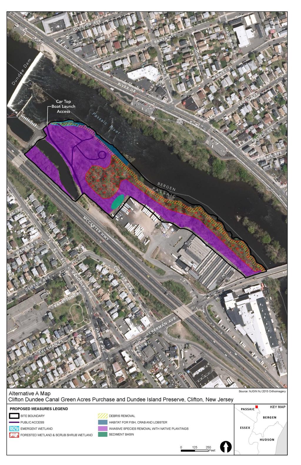
11 Passaic River, Lower Passaic Planning Region Clifton Dundee Canal Green Acres Other Restoration Sites in Region Baseline Conditions and Water Resource Problems HRE- Clifton Dundee Canal Green Acres Purchase This site consists of approximately 1,800 linear feet of the western shoreline of the Lower Passaic River downstream of the Dundee Dam in Clifton, NJ. Rt 21 and a commercial property border the landward side of the site. The City of Clifton has established Dundee Island Park within the site which includes a trail network, benches, interpretive signage and fish consumption advisory signage. This site includes the Safas property, which is subject to an NJDEP environmental investigation/cleanup (NJDEP case # E ). Large volumes of flood-driven woody debris and floatable trash has been deposited along the shore of the central portion of the site, immediately below a low, flat peninsula projecting out into the river. An ancient stone fish weir is present in the middle of the river between this site and the Semel Ave & River Road Parcel site. An active vagrant campsite strewn with trash was observed within the southern portion of the site near Ackerman Ave during the site visit. Restoration Opportunities/Measures Invasive species removal and native plantings Bank stabilization Alternative A B C Debris and invasive vegetation removal, re-grading, and planting Debris and invasive vegetation removal, re-grading, of native emergent wetland (0.1 Restoration and stabilization of and planting of native emergent wetland Debris, fill and invasive vegetation removal and planting with riparian forest. Invasive species vegetation (0.1 native trees and shrubs to restore and create habitat for removal and planting with native Remove invasive plant species and plant with waterbirds (2.84 vegetation to create a forest native vegetation to create a forest accessible to Restoration and stabilization of riparian forest. Invasive species accessible to avian migrants and avian migrants and residents. Conduct grading to removal and planting with native vegetation to create a forest residents. Grading to improve provide proper hydrology and soil stability within accessible to avian migrants and residents. Grading to improve hydrology and soil stability within the riparian zone (totaling 7.86 acres). hydrology and soil stability within the riparian zone (5.50 the riparian zone (7.93 Debris removal along stable shoreline (0.82 Remove debris along stable shoreline (0.82 acres). Debris removal along stable Support Dundee Island Preserve plans for Support Dundee Island Preserve plans for improvements to shoreline (0.82 improvements to riparian floodplain by riparian floodplain by reconnecting riparian buffers and Support Dundee Island Preserve reconnecting riparian buffers and floodplains to floodplains to the estuary to provide a range of quality habitats to plans for improvements to riparian the estuary to provide a range of quality habitats aquatic organisms. floodplain by reconnecting riparian to aquatic organisms. Debris removal, improvement of shallow water habitat with buffers and floodplains to the Debris removal, improvement of shallow water incorporation and/or preservation of natural cobble and riffle estuary to provide a range of quality habitat with incorporation and/or preservation of structures (0.27 habitats to aquatic organisms. natural cobble and riffle structures (0.27 Installation of sediment basin to treat stormwater runoff (0.11 Support Dundee Island Preserve Installation of sediment basin to treat stormwater plans for improvements to public runoff (0.11 Support Dundee Island Preserve plans for improvements to public access. Creation of public trails Support Dundee Island Preserve plans for access. Creation of public trails through native vegetation habitat through native vegetation habitat improvements to public access. Creation of public (1,081 lf), public overlook (0.01 ac), and public boat launch with (1,081 lf) and public overlook (0.01 trails through native vegetation habitat (1,081 lf) access road. and public overlook (0.01 Description Average Annual Functional Capacity Units (AAFCUs) Project Cost $11,950,000 $10,750,000 $9,530,000 Avg Annual Cost $457,250 $411,330 $364,650 Average Cost/AAFCU Alternative A is the Best Buy Plan Secondary benefits of water quality improvements Public education/access $31,690 $49,140 $54,180 Significance of Restoration in the Region and at the Site Shoreline stabilization will reduce erosion and turbidity in waters. Restoration and enhancement actions would reduce nutrient inputs to the waters and increase opportunity for nutrient transformation. T&E species habitat will be enhanced; stabilizes ecologically significant urban wetlands/riparian areas. Shoreline stabilization and habitat improvements will provide secondary benefits of flood control to a flood prone area. Provides for additional public access and education opportunities. Advancement of TECs and Regional Goals Environmental Justice: Restoration and improvements to underserved communities

12 Tentatively Selected Plan Design
Tentatively Selected Plan within Harlem River, East River and Western Long Island Sound Planning Region. First Level Costs. Federal Non-Federal Total
 HARLEM RIVER, EAST RIVER AND WESTERN LONG ISLAND SOUND PLANNING REGION Flushing Bay and Creek Ecosystem Restoration Source Feasibility Study Background Study Resolution (1994), Reconnaissance Report (1996),
Restoring Water Ecosystems in NYC Parks
 Restoring Water Ecosystems in NYC Parks Hooked on our Waters Con October 19, 2013 - CUNY Graduate Center Marit Larson NYC Parks Landscape and ecosystem focus Watershed Streams Freshwater wetlands Tidal
North Branch of Cypress Creek Ecological Restoration: A Comprehensive Approach to Stream Restoration
 North Branch of Cypress Creek Ecological Restoration: A Comprehensive Approach to Stream Restoration Rocky Powell Clear Creeks Consulting, LLC Keith D. Tate, P.E. BayLand Consultants & Designers, Inc.
Planning for Staten. Habitat Restoration and Green Infrastructure. Island s North Shore
 Habitat Restoration and Green Infrastructure Planning for Staten Island s North Shore Community Board 1 March 1, 2018 NYC Parks Forestry, Horticulture, and Natural Resources Funded by the NYS Department
Baylands Segment J. Bay between the Golden Gate and Segment J. Coyote Point. of For managed ponds. included habitat enhancement.
 Baylands Segment J Crissy Field Alameda Naval Air Station Heron's Head Park COLMA CREEK SFO Millbrae San Mateo BAYLANDS 2009 SAN FRANCISCO AREA san francisco area Western side of central San Francisco
Green Infrastructure. NYS Department of Environmental Conservation
 Green Infrastructure Green infrastructure is an interconnected network of natural areas and open spaces that sustains ecosystems. Benedict, M.A. and E.T. McMahon. 2006. Green Infrastructure Linking Landscapes
The Napa River Flood Protection Project
 The Napa River Flood Protection Project Creating Flood Protection and Restoring Geomorphic and Biological Processes Jeremy Sarrow, Napa County Flood Control & Water Conservation District June 2, 2014.
Planning for Staten. Habitat Restoration and Green Infrastructure. Island s North Shore
 Habitat Restoration and Green Infrastructure Planning for Staten Island s North Shore Walker Park December 7, 2017 NYC Parks Forestry, Horticulture, and Natural Resources Funded by the NYS Department of
Bristol Marsh Heritage Conservancy
 Bristol Marsh Heritage Conservancy The Pennsylvania Environmental Council (PEC) protects and restores the natural and built environments through innovation, collaboration, education and advocacy. PEC believes
KENT COUNTY STORMWATER MAINTENANCE DISTRICT STORMWATER BMPs MAINTENANCE TASKS AND RESPONSIBILITIES GUIDANCE DOCUMENT BIO-RETENTION FACILITIES
 BIO-RETENTION FACILITIES (for all basins / BMPs) Annually Prepare Operation and Maintenance Plan. Clearly outline how vegetation in the facility and its buffer area will be managed or harvested in the
STREAM BANK STABILIZATION THORPS MORTIMER RECREATION AREA Grandfather Ranger District SITE LOCATION & DRAINAGE AREA
 STREAM BANK STABILIZATION THORPS CREEK @ MORTIMER RECREATION AREA SITE LOCATION & DRAINAGE AREA SITE LOCATION Drainage Area = 1.14 sq. miles STREAM BANK STABILIZATION THORPS CREEK @ MORTIMER RECREATION
ADOPTED CAPITAL IMPROVEMENT PROGRAM BUDGET ARROYO PROJECTS
 ADOPTED CAPITAL IMPROVEMENT PROGRAM BUDGET ARROYO PROJECTS HAHAMONGNA FY 212-216 Capital Improvement Program Priority Description Total Estimated Costs Appropriated Through FY 211 Adopted FY 212 FY 213
OPPORTUNITIES AND CONSTRAINTS - OXBOW PARK ENTRANCE AND PUT-IN
 OPPORTUNITIES AT OXBOW EXISTING WETLANDS Site is undeveloped and we can design a park that works well from the start. SAND BEACH Potential to eliminate invasive species. DEBRIS (CONCRETE, OLD CARS) VEGETATION
Lake and Stream Restoration Project
 Pre-project Fact Sheet May 2012 Toledo Botanical Garden (TBG) is a 60 acre public garden visited by more than 120,000 people annually. It is located in Toledo, Ohio in the Ottawa River watershed within
Jill Stachura STORMWATER BMP AND STREAM RESTORATION IN A CITY PARK. October 2013 Southeast Stormwater Association Annual Conference, Charlotte, NC
 Jill Stachura STORMWATER BMP AND STREAM RESTORATION IN A CITY PARK October 2013 Southeast Stormwater Association Annual Conference, Charlotte, NC Project Location Gwinnett County, GA: Population: 825,000
North Carolina Coastal Federation
 North Carolina Coastal Federation Erosion Control: Non-Structural Alternatives A Shorefront Property Owner s Guide Shoreline erosion and landward migration of marshes are natural processes, and are important
Use of Best Management Practices
 Use of Best Management Practices Presented at the ANJEC Flood Hazard Workshop Bordentown, NJ March 13, 2008 Stormwater BMPs "a technique, measure or structural control that is used for a given set of conditions
Northern Branch Corridor SDEIS March 2017
 14. Water Quality 14.1. Chapter Overview 14.1.1. Introduction This section discusses changes to the potential for activities associated with the development and operation of the Preferred Alternative to
Basic Information: Vernal Pool Systems
 Basic Information: Assessment Area Name: Project Name: Assessment Area ID #: Project ID #: Assessment Team Members for This AA Date: AA Location: Latitude: Longitude: Datum: Wetland Category: Natural Constructed
4.0 Restoration Opportunities
 4.0 Restoration Opportunities The overall program goal of the Hudson-Raritan Estuary Study is the restoration of the estuary through the establishment of a mosaic of habitats that provide society with
PRE-DESIGN CONCEPT REPORT GRAND CANAL RESTORATION
 PRE-DESIGN CONCEPT REPORT GRAND CANAL RESTORATION Project Background November 19, 2007 Executive Summary The Grand Canal is an important tidal waterway in the Venice community of Los Angeles, California,
Guiding Landowners in Stream Restoration. The Science, Practice & Art of Restoring Native Ecosystems 2015
 Guiding Landowners in Stream Restoration The Science, Practice & Art of Restoring Native Ecosystems 2015 January 24, 2015 Guiding Landowners in Stream Restoration January 24, 2015 Agenda 1Watershed Planning
Summary of Changes in the DRAFT Rivers Project Natural Resource Master Plan from the 2001 approved plan to 2014 plan
 Summary of Changes in the DRAFT Rivers Project Natural Resource Master Plan from the 2001 approved plan to 2014 plan The entire Master Plan format and layout has been changed to comply with regulation
JAMAICA BAY TASK FORCE MEETING
 JAMAICA BAY TASK FORCE MEETING Wednesday, February 16, 2005 6:00-8:30pm Floyd Bennett Field Ryan Visitors Center Flatbush Avenue Brooklyn, NY (718) 338-3876 Car: Belt Parkway to exit 11 south. Continue
Restoration of Riparian Buffer at the Former Smelt Hill Dam Site, Falmouth, Maine
 Restoration of Riparian Buffer at the Former Smelt Hill Dam Site, Falmouth, Maine Final Report June 30, 2006 Page 1 of 16 I. Project Title Restoration of Riparian Buffer at the Former Smelt Hill Dam Site,
Kevin M. Rampe, President -- Lower Manhattan Development Corporation
 For Internal Use Only: Date Received: WRP no. DOS no. NEW YORK CITY WATERFRONT REVITALIZATION PROGRAM Consistency Assessment Form Proposed actions that are subject to CEQR, ULURP or other local, state
Lilburn, GA STORMWATER BMP AND STREAM RESTORATION IN A CITY PARK. July 2013 Jill Stachura
 Lilburn, GA STORMWATER BMP AND STREAM RESTORATION IN A CITY PARK July 2013 Jill Stachura Project Location Gwinnett County, GA: Population: 825,000 Area: 437 sq. miles 1,300 miles storm drainage system
Urban Conservation Practice Physical Effects ESTABLISHMENT, GROWTH, AND HARVEST NUTRIENT MANAGEMENT
 NOT WELL 800 - Urban Stormwater Wetlands A constructed system of shallow pools that create growing conditions for wetland plants to lessen the impacts of stormwater quality and quantity in urban areas.
Poisoned Park? How Exide s Lead Contamination Risks Frisco s Grand Park
 Frisco City Hall has big plans to transform Stewart Creek into a Grand Park with lots of water features for kids to play in. Poisoned Park? How Exide s Lead Contamination Risks Frisco s Grand Park But
C-12. Dry Pond. Design Objective
 C-12. Dry Pond Design Objective The primary purpose of dry pond is to attenuate and delay stormwater runoff peaks. Dry ponds hold water immediately after a storm event and drain to be almost complete dry
ADDENDUM TO BIOLOGICAL SCOPING SURVEY REPORT, BOTANICAL SURVEY AND WETLAND DELINEATION
 ADDENDUM TO BIOLOGICAL SCOPING SURVEY REPORT, BOTANICAL SURVEY AND WETLAND DELINEATION FOR AVALON INN (APN 069-241-27 & -04) 1201 & 1211 NORTH MAIN STREET FORT BRAGG, CA MENDOCINO COUNTY prepared for:
Samuel E. Paul War Memorial Recreation Area Natural Resource Inventory
 Samuel E. Paul War Memorial Recreation Area Natural Resource Inventory Created By: Timothy Rosadini Keene State College Environmental Studies Acknowledgments I would like to acknowledge the following people
FirstLight Power Shoreline Management Manual Sustainable Shoreline Designs: From Long Island to Lake Erie Webinar Series
 FirstLight Power Shoreline Management Manual Sustainable Shoreline Designs: From Long Island to Lake Erie Webinar Series Presented by Jason Williams, PLA, NCI February 19, 2017 Introduction Lakes (impoundments)
ALTERNATIVE SHORELINE MANAGEMENT IN COASTAL MISSISSIPPI
 ALTERNATIVE SHORELINE MANAGEMENT IN COASTAL MISSISSIPPI Project supported via financial assistance provided by the Coastal Zone Management Act of 1972, as amended, administered by the Office of the Ocean
Rule D Wetland and Creek Buffers
 Rule D Wetland and Creek Buffers 1 Policy It is the policy of the Board of Managers to ensure the preservation of the natural resources, recreational, habitat, water treatment and water storage functions
Stream Restoration: Working with Nature?
 Stream Restoration: Working with Nature? Greg Jennings, PhD, PE jenningsenv@gmail.com Ecosystem Restoration activities that initiate or accelerate the recovery of ecosystem health, integrity, and sustainability
Stream Restoration: Working with Nature? Greg Jennings, PhD, PE
 Stream Restoration: Working with Nature? Greg Jennings, PhD, PE jenningsenv@gmail.com Ecosystem Restoration activities that initiate or accelerate the recovery of ecosystem health, integrity, and sustainability
RECREATION, OPEN SPACE AND GREENWAYS ELEMENT GOALS, OBJECTIVES, AND POLICIES
 RECREATION, OPEN SPACE AND GREENWAYS ELEMENT GOALS, OBJECTIVES, AND POLICIES GOAL R-1: DEVELOP A RECREATION, OPEN SPACE AND GREENWAYS SYSTEM AS AN INTEGRAL COMPONENT OF AN OVERALL, COUNTY-WIDE ECONOMIC
PHASE 3-4 PARKS SOUTH PARK AND CHANNEL PARK
 PHASE 3-4 PARKS SOUTH PARK AND CHANNEL PARK Sheet List L1.0 L2.0 L3.0 L4.0 L5.0 L6.0 L7.0 L8.0 L9.0 L10.0 L11.0 L12.0 L13.0 L14.0 L15.0 L16.0 L17.0 L18.0 L19.0 L20.0 L21.0 L22.0 Cover Open Space Context
Old Mill Community Association Bioretention Facility
 Project Overview This project will install a bioretention facility in a community recreation area owned by the Old Mill Community Association, Inc. Drainage from the area is currently unmanaged and has
Landfill Closure, Intermediate Cover & Post-Closure Care. Municipal League Meeting
 Landfill Closure, Intermediate Cover & Post-Closure Care Municipal League Meeting 9-7-17 Gated and Closed Landfill Gated means no longer accepting waste. Closed means gated and final cover has been installed
Jack Creek Park Capital Improvement Project
 Jack Creek Park Capital Improvement Project Public Information Meeting October 2, 2017 Consultants & Designers, Inc. Integrating Engineering and Environment 7455 New Ridge Road, Suite T Phone: (410) 694-9401
Urban Water Management (ESRM 311 & SEFS 507) Cougar Mtn Regional Wildland Park & Lakemont Blvd, Bellevue WA
 Cougar Mtn Regional Wildland Park & Lakemont Blvd, Bellevue WA") Urban Water Management (ESRM 311 & SEFS 507) Cougar Mtn Regional Wildland Park & Lakemont Blvd, Bellevue WA Lecture Today Urban Water management terms Examples of water management in urban areas Field
Urban Water Management (ESRM 311 & SEFS 507) Cougar Mtn Regional Wildland Park & Lakemont Blvd, Bellevue WA Lecture Today Urban Water management terms Examples of water management in urban areas Field
SOUTH FOX MEADOW STORMWATER IMPROVEMENT PROJECT
 VILLAGE OF SCARSDALE WESTCHESTER COUNTY, NEW YORK COMPREHENSIVE STORM WATER MANAGEMENT SOUTH FOX MEADOW STORMWATER IMPROVEMENT PROJECT In association with WESTCHESTER COUNTY FLOOD MITIGATION PROGRAM Rob
Coastal Planning in Texas. Tony Williams Senior Director of Planning Coastal Resources Division Texas General Land Office
 Coastal Planning in Texas Tony Williams Senior Director of Planning Coastal Resources Division Texas General Land Office e The Texas General Land Office (GLO) and the Texas Coast Since 1836: Manager of
The use of low head weirs to. perennial streams with their floodplains:
 The use of low head weirs to reconnect severely entrenched perennial streams with their floodplains: An Anne Arundel County TMDL Watershed Implementation Plan Strategy presented by Hala Flores, P.E Mid
Chapter 5: Natural Resources and Environment
 NATURAL RESOURCES AND ENVIRONMENT 5-1 5 Chapter 5: Natural Resources and Environment BACKGROUND AND INTENT Urban expansion represents the greatest risk for the future degradation of existing natural areas,
Northern Branch Corridor SDEIS March 2017
 Northern Branch Corridor SDEIS March 2017 15. 15.1. Chapter Overview 15.1.1. Introduction This chapter discusses changes to the Preferred Alternative resulting in the potential for project improvements
Introduction. Integrating Ecological Restoration of Estuarine Shorelines with Urban Community Revitalization Efforts. Ed Morgereth Biohabitats, Inc.
 Introduction Integrating Ecological Restoration of Estuarine Shorelines with Urban Community Revitalization Efforts Ed Morgereth Biohabitats, Inc. 5 th National Conference & Expo on Coastal and Estuarine
MILL POND OVERLOOK. A project of the Town of Oyster Bay. Prepared by Cameron Engineering & Associates, LLP
 MILL POND OVERLOOK A project of the Town of Oyster Bay Prepared by Cameron Engineering & Associates, LLP Funded in part through an EPF grant from the NYS Department of State Project Goals & Advisory Committee
APPENDIX C NATURAL RESOURCES MANAGEMENT PLAN: ACTIONS AND PRIORITIES
 APPENDIX C NATURAL RESOURCES MANAGEMENT PLAN: ACTIONS AND PRIORITIES TABLE C-1: Resource Actions and Priorities GOAL NRM-4 Objective 4.1: Restore Natural floodplain functions. Objective 4.2: Define and
Boardman River Watershed VILLAGE OF KALKASKA. WATER QUALITY ACTION PLAN Fall 2009
 Boardman River Watershed VILLAGE OF KALKASKA WATER QUALITY ACTION PLAN Fall 2009 Partners: The Watershed Center Grand Traverse Bay Northwestern Michigan College - Great Lakes Water Studies Institute Grand
Regional Restoration Planning:
 Regional Restoration Planning: A Case Study in Collaborative Restoration Science and Planning Campbell Ingram, Executive Officer NCER August 28, 2018 Co-Equal Responsibilities Act as a primary state agency
Once Upon a Gravel Pit: Reconnecting Floodplain through Aggregate Extraction
 Once Upon a Gravel Pit: Reconnecting Floodplain through Aggregate Extraction 5 th International Conference on Natural Channel Systems September 26, 2016 1 The Story of Snyder s Flats Historical influences
Northern Branch Corridor DEIS December 2011
 16 Floodplains 161 Chapter Overview 1611 Introduction The flowing chapter identifies floodplains found within the Northern Branch Corridor in accordance with Executive Order 11988, Floodplain Management
Is a Riparian Restoration Still Viable After 100-year Storm Events Alter the Original Design?
 Is a Riparian Restoration Still Viable After 100-year Storm Events Alter the Original Design? Sarah Spear Cooke, Ph.D. Seattle, Washington Presentation Outline Introduction The site pre-restoration Restoration
15. Wetlands Chapter Overview Introduction
 15. Wetlands 15.1. Chapter Overview 15.1.1. Introduction Pursuant to Presidential Executive Order 11990 entitled Protection of Wetlands, the United States Department of Transportation (USDOT) developed
KISHWAUKEE MUNICIPALITIES PLAN FOR SUSTAINABLE DEVELOPMENT
 KISHWAUKEE MUNICIPALITIES PLAN FOR SUSTAINABLE DEVELOPMENT 4 "Natural areas, parks and open space create a high quality of life that attracts tax-paying businesses and residents to communities." Trust
Chapter 131 GENERAL REFERENCES
 Chapter 131 STREAM CORRIDOR PROTECTION ZONE 131-1. Objectives. 131-2. Definitions. 131-3. Establishment of the Stream Corridor Protection Zone. 131-4. Uses permitted. 131-5. Uses expressly prohibited.
Hunts Point Landing, Bronx, New York
 Hunts Point Landing, Bronx, New York Sustainable Shorelines in an Urban Environment John Roebig, PhD. HDR Engineering, Inc. John.Roebig@hdrinc.com Promoting Resilient Shorelines along the Hudson River
New Brighton Park Shoreline Habitat Restoration Project
 Vancouver Board of Parks and Recreation and Port Metro Vancouver New Brighton Park Shoreline Habitat Restoration Project Conceptual Design Public Consultation August 26 September 9, 2015 Discussion Paper
Information for File MMJ Main Stem Bassett Creek Restoration Project
 Information for File 2013-03866-MMJ Main Stem Bassett Creek Restoration Project Applicant: Minneapolis Park and Recreation Board (MPRB) Corps Contact: Melissa Jenny Address: Corps of Engineers, St. Paul
LOUISIANA STATE UNIVERSITY COMPREHENSIVE & STRATEGIC CAMPUS MASTER PLAN. APPENDIX G - Stormwater Study Findings & Stormwater Solutions
 LOUISIANA STATE UNIVERSITY COMPREHENSIVE & STRATEGIC CAMPUS MASTER PLAN APPENDIX G - Stormwater Study Findings & Stormwater Solutions LSU: MP Narrative July 2017 3.5 Open Space Existing Conditions The
Homeowners Guide to Stormwater BMP Maintenance
 Homeowners Guide to Stormwater BMP Maintenance What You Need to Know to Take Care of Your Property Rain Barrel Dry Well Rain Garden Pervious Asphalt Porous Pavers City of El Monte Stormwater BMP Management
WET PONDS INSPECTION & MAINTENANCE CHECKLIST
 WET PONDS INSPECTION & MAINTENANCE CHECKLIST INTRODUCTION Once construction is completed, periodic site inspections are essential in order to monitor the effectiveness and to anticipate the maintenance
Empowering Local Action for Coastal Resilience in Massachusetts. Bruce K. Carlisle MA Office of Coastal Zone Management
 Empowering Local Action for Coastal Resilience in Massachusetts Bruce K. Carlisle MA Office of Coastal Zone Management Context Coastal communities continue to face both chronic and acute storm surge, erosion,
Storm Water Quality and Shoreline Restoration Improvements - Grant Funding Request City of Mound Carlson Park Bolton & Menk Project No.
 September 15, 2016 Brett Eidem Cost Share Grant Administrator Minnehaha Creek Watershed District 15320 Minnetonka Boulevard Minnetonka, MN 55345 RE: Storm Water Quality and Shoreline Restoration Improvements
Environmental Protection Ordinances (Performance Zoning) Bedminster Township, Bucks County
 Bedminster Township, Bucks County") Environmental Protection Ordinances (Performance Zoning) Bedminster Township, Bucks County ARTICLE VI. PERFORMANCE STANDARDS Section 600 Compliance All uses, activities, subdivisions and/or land developments
Environmental Protection Ordinances (Performance Zoning) Bedminster Township, Bucks County ARTICLE VI. PERFORMANCE STANDARDS Section 600 Compliance All uses, activities, subdivisions and/or land developments
Worksheet #14 Water Runoff Management
 Water Runoff Management Use this worksheet to assess how well your property minimizes the potential for water runoff and property damage.. Why should you be concerned? What can you do? Rural runoff, also
Habitat Improvements to the Motor Island Shoreline in the Upper Niagara River, NY: A Collaborative Approach
 Habitat Improvements to the Motor Island Shoreline in the Upper Niagara River, NY: A Collaborative Approach Edward Alkiewicz 1, Stephen Schoenwiesner 1, Jeff Gerlach 1, Morris Perot 2, Scott Ault 2, Mark
A Review of Green Infrastructure Projects Implemented in the Grand Traverse Region
 A Review of Green Infrastructure Projects Implemented in the Grand Traverse Region Sarah U Ren Program Director The Watershed Center of Grand Traverse Bay 231-935-1514, suren@gtbay.org Our Mission: The
The scope of the plan will focus on the Prospect Heights Slough and Hillcrest Lake as one entity.
 Plan for Prospect Heights Natural Resources Commission Plan for Improved Public Access and Enjoyment of the Prospect Heights Slough and Hillcrest Lake July 23, 2018 The City Council has requested the Natural
319 Grant: Baker Creek & Centenary Creek Restoration Initiative
 319 Grant: Baker Creek & Centenary Creek Restoration Initiative Objectives: Overview of Watershed Characteristics: Discussion of Project Tasks: Discussion of Watershed Management Plan: Presented by: Erich
Stormwater BMP and Stream Restoration in a City Park. Jeff Herr P.E., D.WRE Jill Stachura
 Stormwater BMP and Stream Restoration in a City Park Jeff Herr P.E., D.WRE Jill Stachura 770.673.3673 JHerr@BrwnCald.com Project Location Camp Creek in Metro Atlanta 7 sq. mile drainage area at project
Improving Communities Through the Arroyo Seco Sustainability Campaign and Watershed Assessment
 Improving Communities Through the Arroyo Seco Sustainability Campaign and Watershed Assessment Arroyo Seco Headwaters in the San Gabriel Mountains Major tributary to the Los Angeles River 44 square mile
Urban Water Management and Soils (ESRM 311 & SEFS 507)
") Urban Water Management and Soils (ESRM 311 & SEFS 507) Cougar Mtn Regional Wildland Park & Lakemont Blvd, Bellevue WA Lecture Today Some Urban Water management terms Examples of water management in urban
Urban Water Management and Soils (ESRM 311 & SEFS 507) Cougar Mtn Regional Wildland Park & Lakemont Blvd, Bellevue WA Lecture Today Some Urban Water management terms Examples of water management in urban
Department of Agriculture. Conservation Service. United States. Natural Resources REVISED 8/26/16
 GENERAL NOTES: SYMBOL LEGEND 1. All work shall comply with the constriction specifications, drawings, project-specific quality assurance plan and other contract requirements. 2. All notes on the drawings
Arlington County Watershed Retrofits. Greg Hoffmann Center for Watershed Protection
 Arlington County Watershed Retrofits Greg Hoffmann Center for Watershed Protection March 18, 2010 About the Center for Watershed Protection Non-profit 501(c)3, non-advocacy organization Work with watershed
Green Design Principles
 Green Design Principles restoration planting Ecosystem restoration, including preserving and enhancing existing vegetation and where feasible, introducing new vegetative communities, benefits the stream
Stormwater Low Impact Development - A Natural Solution
 Stormwater Low Impact Development - A Natural Solution Sarah U Ren Program Director The Watershed Center of Grand Traverse Bay 231-935-1514, suren@gtbay.org Our Mission: The Watershed Center advocates
East Montpelier SWMP Preliminary BMP Summary Sheet BMP ID #: 1 Site name: U-32 High School. Current site type
 East Montpelier SWMP Preliminary BMP Summary Sheet BMP ID #: 1 Site name: U-32 High School 930 Gallison Hill Rd, East Montpelier, VT Filter Berm, Sand Filter, Cistern / Rain Barrel, Gravel Wetland, Check
ARROYO PROJECTS ADOPTED CAPITAL IMPROVEMENT PROGRAM BUDGET
 A RROYO P ROJECTS ADOPTED CAPITAL IMPROVEMENT PROGRAM BUDGET FISCAL YEARS 214-218 HAHAMONGNA Priority Description 1 Hahamongna Watershed Park - Implement Master Plan 211,6 211,6 (77565) 2 Hahamongna -
MINNEHAHA GLEN FEASIBILITY STUDY
 THE KESTREL DESIGN GROUP, INC. 2007 Prepared for: Prepared by: Minnehaha Creek Watershed District Minneapolis Park and Recreation Board The Kestrel Design Group, Inc. Wenck Associates ISSUES AND STRATEGIES:
Baylands Segment P. 206 The Baylands and Climate Change: What We Can Do COYOTE CREEK
 Baylands Segment P BAYLANDS coyote 2009 creek area COYOTE Southern CREEK end of San Francisco Bay AREA between Alviso Slough and Albrae Slough Southern end of San Francisco Bay Baylands between Alviso
April 11, 2016 Park Board Chair and Commissioners General Manager Vancouver Board of Parks and Recreation New Brighton Salt Marsh - Preferred Concept
 TO: FROM: SUBJECT: April 11, 2016 Park Board Chair and Commissioners General Manager Vancouver Board of Parks and Recreation New Brighton Salt Marsh - Preferred Concept RECOMMENDATION A. THAT the Vancouver
Rain Gardens. A Welcome Addition to Your Landscape
 Rain Gardens A Welcome Addition to Your Landscape Where Does The Rainwater Go? Naturally, forests provide a way for rainwater to percolate into the soil, filtering pollutants while trees are allowed to
continues in the watershed, additional flood control and water quality / natural system improvements may be required in the future.
 The Duck Pond Watershed is located in northern Hillsborough County in an area in which a number of land and water management issues are currently being addressed by citizen's action groups and state, regional
Working Group Meeting
 April 4,, 2017 Parks Operations Bldg Working Group Meeting Arts Districts Overview Stormwater/RPA/Stream Considerations First Principles Agenda 7:00pm 7:05pm 7:10pm 7:40pm 8:30pm 9:40pm 9:45pm Welcome
SUPPORTING DOCUMENT STORMWATER POLLUTION PREVENTION PLAN (SWPPP) NARRATIVE
 NARRATIVE") SUPPORTING DOCUMENT STORMWATER POLLUTION PREVENTION PLAN (SWPPP) NARRATIVE Please complete this narrative form and submit with your SWPPP drawings. Refer to Kitsap County Stormwater Design Manual Vol.
SUPPORTING DOCUMENT STORMWATER POLLUTION PREVENTION PLAN (SWPPP) NARRATIVE Please complete this narrative form and submit with your SWPPP drawings. Refer to Kitsap County Stormwater Design Manual Vol.
ME DOT Route 3. File No.: City and State: Bar Harbor, ME
 ME DOT Route 3 File No.: 199600361 City and State: Bar Harbor, ME General Impacts: 0.28 acre tidal emergent 0.77 acre non-tidal forested 0.15 acre non-tidal emergent 0.51 acre non-tidal scrub-shrub Functions
Urban runoff in my neighborhood (Capitol Hill) is heavy with trash and other debris.
 is heavy with trash and other debris.") South Platte River Meeting Comments & s #1 I am a huge fan of river areas and would love the Platte and surrounding waterways to improve to allow habitat for wildlife and recreation opportunities for citizens.
South Platte River Meeting Comments & s #1 I am a huge fan of river areas and would love the Platte and surrounding waterways to improve to allow habitat for wildlife and recreation opportunities for citizens.
Triangle Land Conservancy Conservation Area Monitoring Report Carolina North
 Triangle Land Conservancy Conservation Area Monitoring Report Carolina North Property Name: Bolin Creek West Conservation Area Date of first visit: 3.12.14 County: Orange Date of second visit: 6.5.14 Property
MCCOYS CREEK RESTORATION 30% DESIGN
 MCCOYS CREEK RESTORATION 30% DESIGN THE MCCOYS CREEK RESTORATION PLAN The restoration plan aims to reduce flooding, restore ecosystem health, expand recreational opportunities along the creek, and connect
BASS PONDS, MARSH, & WETLAND HABITAT RESTORATION PROJECT
 FACT SHEET BASS PONDS, MARSH, & WETLAND HABITAT RESTORATION PROJECT MINNESOTA VALLEY NATIONAL WILDLIFE REFUGE, MINNESOTA ENVIRONMENTAL MANAGEMENT PROGRAM LOCATION Three areas located on the Minnesota Valley
McArthur Swamp Planning Unit. Fish, Plant, and Wildlife Habitat MCARTHUR SWAMP PLANNING UNIT
 McArthur Swamp Planning Unit Fish, Plant, and Wildlife Habitat Conduct surveys of the planning unit to identify biological resources and enable their protection. Most of the McArthur Swamp land acreage
Putting the Pieces Together
 Putting the Pieces Together A guided tour of the St Croix Valley's land and water resources A Guided View from the River: What are the challenges and obstacles your community is facing? 1 Site 2 Buk and
Karen A. Duhring Marine Advisory Scientist Center for Coastal Resources Management Virginia Institute of Marine Science College of William & Mary
 Karen A. Duhring Marine Advisory Scientist Center for Coastal Resources Management Virginia Institute of Marine Science College of William & Mary March 20, 2009 Low-Impact Shoreline Stabilization Cumulative
7.0 SOCIAL, ECONOMIC, AND ENVIRONMENTAL ISSUES
 7.0 SOCIAL, ECONOMIC, AND ENVIRONMENTAL ISSUES The following list of social, economic, and environmental issues have been identified based on a preliminary inventory of resources in the project area, an
Project Location. Jay and Patty Baker Park and Gordon River Greenway Connector Bridge. Naples Beach Golf Club. Gordon River. East. Naples.
 Gordon River Project Location Naples Beach Golf Club East Naples Naples Naples Bay Evergreen Golf and Country Club and Gordon River Greenway Connector Bridge Gordon River Greenway CONNECTOR BRIDGE AND
Biodiversity Conservation
 Biodiversity Conservation and Site Plan Review Biodiversity conservation principles Threats to biodiversity Location of development Reviewing site plans Lunch Reviewing site plans (continued) LEED and