CREATIVE VILLAGE. Mobility Plan. May 11, 2017
|
|
|
- Ralf Owen
- 6 years ago
- Views:
Transcription


1 MOBILITY PLAN

2 CREATIVE VILLAGE Mobility Plan Prepared by: Kimley-Horn and Associates, Inc. Orlando Office 3660 Maguire Boulevard, Suite 200 Orlando, Florida In collaboration with: Creative Village Development, LLC 800 N. Orange Avenue, Suite 200 Orlando, Florida Report Author: Heather A. S. Roberts, P.E. Project Manager
3 Contents 1.0 INTRODUCTION/EXECUTIVE SUMMARY COORDINATION WITH OTHER PLANS PROJECT DTO VISION PLAN PARRAMORE COMPREHENSIVE NEIGHBORHOOD PLAN PATHWAYS FOR PARRAMORE INITIATIVE CREATIVE VILLAGE STREETSCAPE DESIGN GUIDELINES ADDITIONAL CREATIVE VILLAGE PLANS CREATIVE VILLAGE TRANSPORTATION ASSESSMENT TECHNICAL REQUIREMENTS OF THE PD CREATIVE VILLAGE DEVELOPMENT DEVELOPMENT PROGRAM ROADWAY NETWORK BICYCLE LANE AND PEDESTRIAN NETWORK PARKING NETWORK TRANSIT NETWORK MOBILITY STRATEGIES PEDESTRIAN BICYCLE TRANSIT SHARED PARKING/RIDE SHARE TECHNOLOGY SUGGESTED MOBILITY STRATEGIES FOR CREATIVE VILLAGE REFERENCES i
4 List of Figures Figure 1: Project DTO Vision Themes... 4 Figure 2: Creative Village Roadway Network...12 Figure 3: Creative Village Phasing...13 Figure 4: Creative Village Pedestrian/Bicycle Access...15 Figure 5: Creative Village Parking Network...16 Figure 6: Bus Routes in Creative Village...18 Figure 7: Additional Transit in Creative Village...19 List of Tables Table 1: Creative Village Phase 1 Development Trip Generation Summary...9 ii
5 1.0 INTRODUCTION/EXECUTIVE SUMMARY Creative Village builds upon the success of Orlando s digital media industry by transforming the former Amway Arena site into a 68-acre mixed-use, transit-oriented, urban infill development in the heart of downtown Orlando. The vision for Creative Village focuses on building a true "live, work, learn and play" urban destination through a development plan that supports a synergistic and dynamic mix of uses including office/creative studios, higher education, PS-8 education, mixed-income residential, retail/commercial and hotel. Creative Village was established on the following design principles: Respect the historic development pattern of the Parramore neighborhood Offer vibrant street life and urban amenities Incorporate innovative technologies into the built environment Promote sustainability in infrastructure and building design Become an authentic transit-oriented development Create green spaces and public plazas Creative Village is designed to provide a mix of convenient transportation options for students, residents, employees, customers and visitors. Leading higher education providers (i.e. UCF and Valencia College); high-tech, digital media and creative companies; and a diverse mix of students, employees and residents will call Creative Village home. Therefore, the Master Plan incorporates pedestrian, bicycle, transit, smart parking and technology features to maximize efficiencies and encourage a variety of mobility choices. The Creative Village site is an urban infill site located in Downtown Orlando, proximate to LYNX Central Station (SunRail Commuter Rail, LYNX Bus Service and LYNX LYMMO Downtown Circulator) and benefits from recently completed or under construction transportation infrastructure projects including the new LYNX LYMMO route (Lime Line) expansion, Livingston Street extension (between Terry and Parramore) and the I-4 Ultimate project. Prior to the TIGER grant and other funding sources that resulted in the expansion of the LYMMO circulator system to the west side and reestablishment of the traditional street grid and block pattern, the Creative Village site was cut off from the east side of downtown Orlando and poorly configured for redevelopment. With the new roads, infrastructure and LYMMO expansion; existing roads and infrastructure; adjacent redevelopment in the Parramore neighborhood; and connections to the LYNX Central Station, the area is now well positioned and appropriately laid out for a mixed-use, urban infill, transit-oriented project like Creative Village. By focusing on complete streets and a variety of mobility options, while also aspiring to being a leader in walkable urban design, Creative Village can become a best in class case study for transitoriented development in Central Florida. 1
6 At buildout, the anticipated development program for Creative Village is summarized below. Up to 1,200,000 square feet of office/creative space 750,000 square feet of higher education space (UCF/Valencia College) 1,500 multifamily residential units 1,500 student housing beds 150,000 square feet of retail/commercial space 225 hotel rooms The goal of the Mobility Plan is to create a road map to making Creative Village an exemplary model of urbanism and transit-oriented development, which aims to raise the bar for Orlando s transit network. Future developers of Creative Village will use the Mobility Plan as a guide for smart and efficient development that incorporates emerging technology and multimodal design features. The mobility strategies identified in this report set aspirational designs and outcomes that encourage good urban design and planning to reduce vehicle miles travelled. The incorporation of these strategies listed within this document will establish Creative Village as a true transit-oriented development, and in doing so, set the standard for Orlando. 2
7 2.0 COORDINATION WITH OTHER PLANS The Mobility Plan for Creative Village is designed to build on previous plans and studies completed in the vicinity. The City of Orlando and other partners have provided great vision for this area, with emphasis on all modes of transportation. The following sections highlight some of these guiding documents. 2.1 PROJECT DTO VISION PLAN The Project DTO Vision Plan was created in 2015 by a broad and diverse group of community stakeholders, a planning consultant and City Staff. It was built on four pillars that provide the framework for a series of strategic actions and partnerships: Strengthen Downtown Orlando s economic competitiveness in the international and national marketplace Enhance its livability as a safe and welcoming urban city center Intuitively integrate health and wellness into our daily life Ensure the sustainability of Downtown s assets for generations to come Recommendations from Project DTO range from improving bicycle and pedestrian amenities, to increasing parks and open space, to recruiting major corporate anchors and high wage jobs, to expanding neighborhood associations and housing options, to encouraging architecture that creates a signature skyline in our Downtown. Vision Principles from Project DTO: We will celebrate our enviable year-round climate and become an awesome outdoor city through walkable streets, active public places, interconnected parks and trails that inspire and sustain a kaleidoscope of outdoor events and activities. We will strengthen our growth-oriented business culture to realize an economically diverse center of commerce and become the tech hub of the South. We will cultivate a myriad of experiences-entertainment, sports, shopping, and cuisine-that will mirror and cater to the diversity of our urban community. We will make it easier to get around. We will have a well-connected, world-class transportation network that is accessible, intuitive, and inviting for everyone. We will be an open urban community where everyone feels safe, respected, welcome, and connected with others. We will lead Florida s education system, include art as part of our STEAM educational equation, support students in their journeys from cradles through careers, and strengthen our creator culture. 3

8 We will let the arts take center stage as we focus on the future. We will become one a unified, proud, galvanized, Downtown Orlando where all of these aspects interconnect and the world identifies Downtown Orlando as a place where momentum is building and anyone can play a part in what happens next. Figure 1 below shows the themes from the Project DTO Vision Plan. Refer to the Project DTO link found in the References section for additional information. Figure 1: Project DTO Vision Themes 4

9 2.2 PARRAMORE COMPREHENSIVE NEIGHBORHOOD PLAN The Parramore Comprehensive Neighborhood Plan completed in 2014 focuses on creating a healthy, sustainable and vibrant community that prepares for the future while preserving, enhancing and celebrating the culture and heritage of Parramore. The Plan is an integral component of the Project DTO Vision Plan, and is also an important continuation and further refinement of the Pathways for Parramore Initiative detailed below. Through numerous community forums and extensive public engagement, the following Ten Healthy Community Design Principles were established and endorsed for the Parramore Comprehensive Neighborhood Plan: 1. Drive Economic Development by Creating a Unique Identity 2. Improve Access to Job Opportunities 3. Promote Social & Environmental Justice 4. Increase Housing Opportunities 5. Make Education the Cornerstone of Revitalization 6. Empower Champions for a Healthy Community 7. Promote Access to Healthy Food 8. Invest in People, not Cars 9. Maximize the Opportunity for All Residents to get Physical Activity 10. Encourage Mixed-Use Development The Parramore Comprehensive Neighborhood Plan contains the community s vision for their neighborhoods based on the above-mentioned Healthy Community Design principles, and provides strategies along with short, mid and long term action items for improving economic and job growth, community health, transportation options, housing, education and infill development. A web link to the plan can be found in the References section. 5


10 2.3 PATHWAYS FOR PARRAMORE INITIATIVE The Pathways for Parramore initiative is a comprehensive effort to revitalize Orlando s historic Parramore community. There have been significant strides made through Pathways for Parramore, including the attraction of new businesses and investment, increasing housing options, reducing crime and enhancing programs for our children. In the years ahead, educational opportunities will expand and transportation options will be enhanced in Parramore. Using the recently completed Parramore Comprehensive Neighborhood Plan as a guide, the City will continue building on the vision for a healthy, sustainable and vibrant community for residents while preserving, enhancing and celebrating the culture and heritage of Parramore. 2.4 CREATIVE VILLAGE STREETSCAPE DESIGN GUIDELINES The Creative Village Streetscape Design Guidelines were finalized in early 2017, and provide direction and guidance for the installation of the landscape, streetscape and hardscape features that are intended to be located within the public rights-of-way and/or public spaces in the Creative Village redevelopment area. The Streetscape Design Guidelines also provide recommendations for Street Furniture within Creative Village to enhance the pedestrian experience and facilitate multi-modal transit, including street benches, bicycle racks, trash receptacles, street lights, planter pots and tree grates. 6
11 The guidelines also detail the aesthetic features for pedestrian walkways within the public right-of-way, and design features for entrances to the Creative Village development area. The Creative Village Development Review Committee (CVDRC) will utilize this set of guidelines to review streetscape improvements within the Creative Village project boundaries. The use of various pavement materials in sidewalks and streets will be incorporated to add visual interest and promote pedestrian and vehicular safety within the Creative Village project. The contrast between alternative pavement material, such as colored pavers, asphalt and concrete, creates a change in pavement feel for pedestrians and drivers which identifies a location that requires extra awareness, as a pedestrian and vehicular encounter may occur. Decorative paver design shall be included as part of the Creative Village streetscape construction drawings and should be used in public and private ground level courtyards, plazas and open gathering spaces to ensure a cohesive and attractive pedestrian environment. Full details on the proposed type, size, color and location for the various pavers within the Creative Village project are provided in the Streetscape Design Guidelines. The Guidelines also identify the preferred location for traffic signal poles, traffic control boxes and other utility features, to maximize pedestrian space and encourage pedestrian activity. Further details on the mobility strategies to maximize pedestrian activity within Creative Village are included in the Mobility Strategies section of this report. 2.5 ADDITIONAL CREATIVE VILLAGE PLANS The Infrastructure Master Plan, Public Art Guidelines and Parks Plan are all part of the master planning process for Creative Village, and should be reviewed in conjunction with this Mobility Plan: 7
12 Infrastructure Master Plan: This plan will analyze the infrastructure and utility network within Creative Village, and provide development guidance to the Master Developer, City and prospective vertical development of individual parcels. Public Art Guidelines: These guidelines will establish a framework for all forms of public art at Creative Village and help prospective individual parcel developers understand expectations for including public art in their developments. Parks Plan: A master plan for the park and public spaces at Creative Village will be developed. 2.6 CREATIVE VILLAGE TRANSPORTATION ASSESSMENT A Transportation Assessment was performed for Creative Village in August The study was initiated to support City review of plans to re-plat parcels within the proposed Creative Village Project and to lay the groundwork for a future Mobility Plan as part of the Creative Village Master Plan. The assessment included the following: Development of a Daily and PM peak hour trip generation estimate for the proposed Phase 1 Development. Identification of the existing and proposed roadway network including primary corridors, circulation patterns and gateway intersections. Review of existing and proposed connectivity plans and pedestrian, bicycle and transit facilities. Evaluation of the transportation elements of the Creative Village conceptual plan for consistency with other plans in the vicinity of the project. The transportation assessment provided an analysis of the trip generation rate adjustments applicable to Creative Village, recognizing its characteristics as a mixed-use, urban infill, transit-oriented development. The anticipated trip generation for all of the Phase 1 parcels of Creative Village is shown in Table 1. Note that the development shown in the table is approximate, based on what is anticipated to be built at the end of Phase 1. 8
13 Table 1: Creative Village Phase 1 Development Trip Generation Summary Daily Land Use ITE LUC Size 1 Units ITE/FDOT Trip Rate 2 Local Reduction 3 Local Trip Rate Daily Trip Generation Total In 2 Out 2 Multi-Family Apartment DU % ,656 50% % 828 High-Rise Apartment DU % ,850 50% % 925 Student Housing - 1,200 Beds % ,791 50% % 895 Office KSF % ,930 50% 1,465 50% 1,465 Retail KSF % % % 244 Total Generated Trips 8,715 4,358 4,357 Internal Capture 4 = 2.2% Net External Trips 8,525 4,263 4,262 Pass by Trips = 34.0% of external retail trips New External Trips 8,382 4,191 4,191 PM Peak Hour Land Use ITE LUC Size 1 Units ITE/FDOT Trip Rate 2 Local Reduction 3 Local Trip Rate PM Peak Hour Trip Generation Total In 2 Out 2 Multi-Family Apartment DU % % % 54 High-Rise Apartment DU % % 93 39% 60 Student Housing - 1,200 Beds % % 94 35% 50 Office KSF % % 70 83% 343 Retail KSF % % 94 52% 101 Total Generated Trips 1, Internal Capture 4 = 11.1% Net External Trips Pass by Trips = 34.0% of external retail trips New External Trips Notes: 1 Land use quantities are the approximate values planned for Creative Village Phase 1 at this time (subject to change). All trip generation calculations included in this table are based on approximate figures for Phase 1 development program. 2 Vehicle trip rates and directional splits per ITE Trip Generation, 9th Edition and per FDOT 2012 study for student housing. Student housing vehicle rate reduced by 50% for nonvehicular capture with adjacent university. 3 25% reduction to baseline rates for infill development, transit proximity, and multimodal design. 4 Internal capture rate per ITE Trip Generation Handbook, 2nd Edition (2004) with updated unconstrained rates from 3rd Edition (2014) for PM peak hour. 2.7 TECHNICAL REQUIREMENTS OF THE PD The technical requirements of this Mobility Plan are listed in Section 3.18 of the PD Ordinance: The Mobility Plan must: o Conform to applicable mobility strategies in effect at the time of the Master Plan submittal. o Identify and incorporate the mobility strategies chosen, a phasing plan for implementation of the strategies, a bicycle and pedestrian circulation plan, an access plan and a roadway circulation plan. o Describe and depict the proposed roadway network, bike lane network, sidewalk network, transit routes and transit nodes. o Include street cross-sections that accommodate private vehicles, transit vehicles, pedestrians and cyclists. Information on the technical requirements of the PD can be found in the relevant sections of this Mobility Plan. 9
14 3.0 CREATIVE VILLAGE DEVELOPMENT The Creative Village redevelopment area is a planned +/- 68-acre mixed-use, transit-oriented, urban infill development to be constructed at the former site of the Amway Arena and surrounding parcels in Downtown Orlando, Florida. The project is being developed by a public/private partnership between the City of Orlando and the Master Developer, Creative Village Development, LLC, pursuant to the Master Development Agreement, PD Zoning Ordinance and other related documents. The redevelopment area is generally located north of the Florida Central Railroad rail spur, east of Parramore Avenue, south of Concord Street (with the exception of Lake Dot Park) and west of Hughey Avenue. The project is in a central location adjacent to Downtown Orlando and the Parramore neighborhood. Creative Village is also ideally located in close proximity to the LYNX Central Station. This project is well positioned to be a true transit-oriented development and provide a mix of mobility options. The contents of the Mobility Plan address the criteria set forth in the PD Zoning Ordinance Further strategies for maximizing mobility within Creative Village are discussed in the Mobility Strategies section of this report. 3.1 DEVELOPMENT PROGRAM Creative Village is zoned planned development (PD) and is currently anticipated to include the following land use and quantities at build-out: Up to 1,200,000 square feet of office/creative space 750,000 square feet of higher education space (UCF/Valencia College) 1,500 multifamily residential units 1,500 student housing beds 150,000 square feet of retail/commercial space 225 hotel rooms The development will occur in multiple phases over ten to fifteen years. Anticipated development of all the Phase 1 parcels consists of eight (8) parcels to be developed as follows: +/- 344 mixed-income multi-family units on Parcels N, P and L +/- 600 market-rate apartment units on Parcels M and U +/- 1,200 student housing beds in two phases on Parcels I, J and K +/- 420,000 square feet of mid-rise to high-rise office, apartment, hotel and/or mixed-use space on Parcels H, X and X-1 Ground floor retail/commercial space in all of the buildings 10
, Colonial Drive (SR 50), Orange Blossom Trail (US 441) and Orange Avenue (SR 527).")
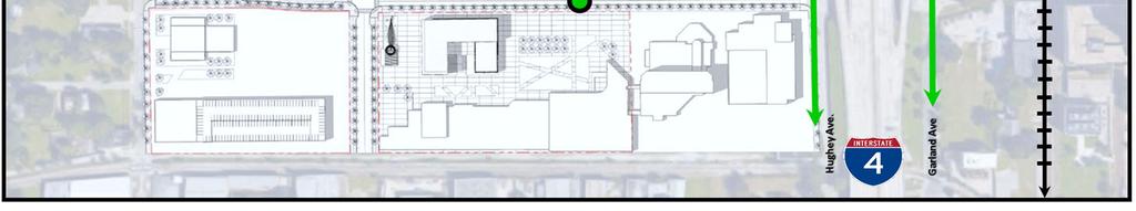
15 3.2 ROADWAY NETWORK Creative Village focuses on an urban road network and strategy of complete streets to provide a safe environment for all users. Regional access is provided via Interstate 4, the East/West Expressway (SR408), Colonial Drive (SR 50), Orange Blossom Trail (US 441) and Orange Avenue (SR 527). Parramore Avenue and Hughey Avenue border Creative Village on the west and east respectively, and are identified as primary north-south corridors. These roadways will incorporate the design details and aesthetic features identified in the Streetscape Design Guidelines. Gateway intersections are identified at Amelia Street and Parramore Avenue, Amelia Street and Hughley Avenue, Livingston Street and Parramore Avenue and Livingston Street and Hughey Avenue. As referenced in the Streetscape Design Guidelines, Amelia Street and Livingston Street will serve as the primary east-west corridors within Creative Village. Livingston Street has been realigned and newly constructed to include two vehicular travel lanes and additional multi-modal features, and Amelia Street exists in its current condition. Terry Avenue will serve as the primary north-south corridor for the initial phase of development within Creative Village. Currently, Terry Avenue is planned to extend from its existing terminus at Robinson Street south of Creative Village to connect to the new segment of Terry Avenue within Creative Village and then up to Concord Street and connect with Lake Dot Circle (west). This Terry Avenue missing link between Robinson Street and Livingston Street is still being studied, but would provide for improved north-south traffic flow for Creative Village by linking the areas to the north and south. Signalized control exists at both Livingston Street and Terry Avenue, and at Amelia Street and Terry Avenue. These primary roads will be complimented by a series of secondary and tertiary roads to integrate multiple travel modes (vehicle, pedestrian, bicycle and transit) into the surrounding transportation network. The primary, secondary and tertiary roadways are shown in Figure 2. In Creative Village, construction of necessary new roadways will occur concurrently with the development of the adjacent parcels. Design for the roadways should follow the street types and cross sections provided in the Streetscape Design Guidelines. This will ensure continuity between phases of development and a logical, orderly and measured development of necessary roads over time. The current phasing map for Creative Village is shown in Figure 3. As a part of the initial part of Phase 1 vertical development (Parcels N, P, J and M) the first roadways to be built within Creative Village will be a portion Federal Street, an eastwest facility which serves Parcels J and M, and the northern leg of Putnam Avenue, to be constructed with the development of Parcels N and P. The southern leg of Putnam Avenue will be built as a part of vertical development of Parcel M. Putnam Avenue is a tertiary facility that provides north-south access within Creative Village between Terry Avenue and Parramore Avenue. Later parts of Phase I or future phases of development include plans for Chatham Avenue, which will run in parallel with Terry Avenue to the east of Central Park from Livingston Street to Lake Dot Circle (east). 11


16 Figure 2: Creative Village Roadway Network 12

17 Figure 3: Creative Village Phasing 13

18 3.3 BICYCLE LANE AND PEDESTRIAN NETWORK Walking and bicycling are anticipated to be important modes of travel within Creative Village and to destinations beyond. In addition to trips expected to be captured onsite, destinations within a 15-minute walk from Creative Village include the Amway Arena, LYNX Central Station, Orlando City Hall, Orange County Courthouse and the Dr. Phillips Performing Arts Center. From LYNX Central Station, many other destinations are accessible via SunRail. Figure 4 shows the planned Creative Village pedestrian and bicycle facilities along with connectivity to surrounding areas. 3.4 PARKING NETWORK Parking facilities within the Creative Village footprint include street parking; parking at existing garages (Centroplex Garages I & II); garage parking in future garages at the student housing project and on the UCF Downtown campus; and parking built as part of future vertical development projects. Parking requirements, capacity, demand, cross utilization and sharing will be assessed as lots are vertically developed. At Creative Village, an integrated master parking plan, not a parcel by parcel approach, should be encouraged. The parking capacity and allocation in Creative Village should be designed to encourage other alternative modes of transportation, including pedestrian, bicycle and transit trips. To achieve this mode split, shared parking and parking reductions should be considered. A coordinated parking program that considers the mixed-use nature of the development in Creative Village and the project s proximity to LYNX Central Station and Downtown Orlando should strive to provide the right balance of parking and multi-modal opportunities. Further strategies for encouraging alternative modes are included in the Mobility Strategies section of this report. Figure 5 shows the planned Creative Village parking areas, including on-street parking and parking garages. It is noted that the existing surface lots are not anticipated to remain as part of the phased build out of Creative Village, and are therefore not shown in Figure 5. 14


19 Figure 4: Creative Village Pedestrian/Bicycle Access 15


20 Figure 5: Creative Village Parking Network 16
21 3.5 TRANSIT NETWORK Creative Village is located in Downtown Orlando in close proximity to transit facilities including standard bus, a downtown circulator (LYMMO), commuter rail (SunRail), LYNX Central Station and the Orlando Urban Trail. Conceptual plans are focused on promoting regional access to Creative Village and surrounding communities via all modes of travel including transit services. Several standard bus routes operate along Amelia Street with stops in Creative Village between LYNX Central Station and regional locations to the west. In addition to standard bus service, LYNX offers the LYMMO circulator which provides another option to easily access LYNX Central Station from Creative Village. LYMMO provides frequent service (15 minutes or less headway) for local routes in and around Downtown Orlando. Buses often use dedicated (bus only) lanes on their routes and the fare is free to riders. LYMMO s Orange Line and Lime Line routes have stops in Creative Village. The Lime Line will help connect Creative Village to Parramore, the Central Business District, Thornton Park, the North Quarter and other destinations in Downtown Orlando. At LYNX Central Station, transit riders will have an option to access Central Florida s SunRail commuter rail system along with the housing, jobs, shopping and entertainment opportunities available near the region s SunRail stations. SunRail s route currently runs from Sand Lake Road Station in Orange County to the DeBary Station in Volusia County. Expansion south to the Poinciana Station in Osceola County will be completed in 2018, and plans to expand SunRail north to the Deland in Volusia county are currently being reviewed. A third phase, which would provide a spur to connect to Orlando International Airport, is being considered. Existing and planned SunRail service, coupled with the LYMMO service, makes Creative Village ideal for transit-oriented development. The transit options in Creative Village are shown in Figures 6 and 7. 17


22 Figure 6: Bus Routes in Creative Village 18


23 Figure 7: Additional Transit in Creative Village 19
24 4.0 MOBILITY STRATEGIES In order to maximize the development potential in Creative Village, and establish this area as an example of true transit-oriented development, all transportation modes must be considered. Development should be designed to emphasize walking, bicycling and transit options as the primary modes of transportation. The car should be viewed as an alternative and secondary mode of transportation within Creative Village. The following sections detail goals and strategies to be implemented with each phase of development in Creative Village. Mobility strategies should be implemented collectively throughout Creative Village as part of the master planning and master development efforts. With Creative Village s central location and convenient access to LYNX Central Station, this project can set the example for true transit-oriented development in Central Florida. The mobility strategies identified in the following sections are intended to create a safe, user-friendly and visually appealing environment for all users of a variety of transit modes. A balanced and collective approach, appropriately considering all modes of transit, should be employed at Creative Village when making decisions and setting policies for transportation and mobility. A goal of the long-term vertical development and buildout of Creative Village is to reduce dependence on the car, thereby reducing the overall vehicle miles travelled. Transit oriented development and walkable urban design should be used to support economic development initiatives and increase transit ridership (i.e. LYMMO and SunRail). Creative Village should be connected to the surrounding areas, including the Parramore neighborhood and new OCPS Pre-Kindergarten through Grade 8 School. Transit options and mobility strategies should connect these areas. Educational programs should be encouraged to inform students on pedestrian, bicycle and transit safety and help acclimate children to mobility options at a young age. The strategies identified include aspirational ideas that will encourage good urban design that can be applied to the development of Creative Village. 20


25 4.1 PEDESTRIAN All modes of transportation trips begin or end as a pedestrian trip. Therefore, it is of utmost importance to have a well-designed, safe, convenient pedestrian network, not only within the public right of way, but also connecting people from public right of way, through parking areas, to transit options and ultimately to the front door of their final destination. Walking should be creatively and intuitively encouraged on all streets to reduce the number of miles travelled by single-user cars, and to achieve greater modal balance within Creative Village. Strategies: Provide safe, convenient and intuitive pedestrian walkways to and through development. Provide a comfortable environment for pedestrians. Consider adopting a low speed limit throughout Creative Village to increase pedestrian comfort. Provide pedestrian space in the private realm, to complement the pedestrian space provided in the public right of way and parks/public spaces. Street infrastructure should be designed to be conducive to slower speeds for pedestrian safety. Roadway design should follow the Streetscape Design Guidelines. Artistic Painted Crosswalks or Sidewalks: Charlotte, NC Wayfinding should be used to direct pedestrians to their destinations. This wayfinding should be incorporated into the development and should be consistent with the overall theming of Creative Village. Development should be designed for and oriented to the pedestrian as the primary means of access. Vehicular access should be secondary. Consider the use of artistic or specially delineated pedestrian crossings in certain focal points to provide better visibility for pedestrian crossings at heavy intersections. Include seating and shading in the design of pedestrian facilities. Consider mid-block crossings for anchor areas like Central Park. Consider shared streets where pedestrians and other transportation modes are mixed together. Integrate pedestrians seamlessly into the transportation network so that pedestrian design is a focal point and not an afterthought. Provide enhanced aesthetic features in pedestrian design elements. 21


26 4.2 BICYCLE Bicycling can provide great connectivity between destinations and other modes of travel. Bicycling is popular among both commuter and recreational users, and is particularly popular with students and millennials that will make up a large portion of the population at Creative Village. Users should be accommodated within the public right of way in a safe and reliable manner to promote bicycle usage and reduce reliance on the automobile, and adequate bike storage and facilities should be provided in buildings and/or parking garages. Strategies: Set up bike share (Juice Bike Share is the current provider) at key places within Creative Village: o Provide appropriate wayfinding and incorporate technology to point users to other destinations with bike share, both within and outside of Creative Village. Colorful Bicycle Racks: Harrisburg, PA The Harrisburg Downtown Improvement District purchased and installed creative bike racks which are functional, but also promote bicycling through their design. Incorporate secure bicycle parking, convenient to education, residential, office and retail uses to promote bicycle riding. Refer to the Parking section for additional bicycle parking strategies. Consider buffered/separated bike lanes on a route connecting to Central Park. Use aesthetically pleasing, but functional designs to incorporate and encourage bicycling. Detroit Slow Roll: Detroit, MI Participants of all ages and skill levels are invited to take place in group bike rides where thousands of riders gain new perspective from viewing their city by bike. Color coded bicycle lanes should be consistent with the City of Orlando s design standards. Incorporate biking culture into Creative Village by providing services for bicycle storage, safety and repair. Attract local bicycle groups. Provide integration with surrounding trail network (i.e. Orlando Urban Trail) by including wayfinding and trail connections within Creative Village. Consider the opportunity to add a cycle track on Amelia Street. 22


27 4.3 TRANSIT Creative Village is being established as a true transit-oriented development. Transit is incorporated into all aspects of the design, and will be used to connect the UCF Downtown campus with the main campus in eastern Orange County. The site is located in close proximity to several transit options including local bus routes and other transit such as the LYMMO circulator and commuter rail (SunRail). Providing access to these transit choices will serve as an economic driver consistent with the preferences of millennials and a new generation of college students. Transit should be considered as an integral part of the development in Creative Village, and not as an afterthought. The intent is to develop a framework that will create a truly transit- integrated development, not simply a development that is adjacent to or oriented toward transit. Strategies: Provide a free bus connection between UCF main campus and UCF Downtown/Creative Village. Explore the opportunity to incorporate Transit Signal Priority (TSP) and other features into signalized intersections in Creative Village. Bus shelters should be user-friendly and convenient: o Covered seating should be included at all transit stops. o Transit routes, connections and service times should be adequately signed at all bus stops. Encourage business use of transportation options through programs like: o Carpooling/ride-share o Direct debit for bus and/or train fees o Employer health rewards programs o Employer subsidies o Student and resident incentives Consider providing on-demand self-driving buses to connect residents to destinations outside of Creative Village. Healthline BRT: Cleveland, OH BRT Stations along the Healthline include a fare vending machine, generous seating, 24-hour lighting, real time text display and station signage. Incorporate technology to enhance the transit experience for users. Allow for evolution of the LYMMO circulator route to streetcar or light rail to account for an increase in population and new technology. 23
28 Consider sharing transit lanes with bicycle users. Continue to evolve and update LYMMO circulator design to reflect a modern and user-friendly system. Consult with national experts, like Jeff Speck, to develop strategies to make Creative Village a leading example of walkable urbanism and transit rich development. 4.4 SHARED PARKING/RIDE SHARE By providing a transportation network and plan that accommodates pedestrian, bicycle, car and transit users, Creative Village will achieve a mode-shift from primary dependence on automobiles, thereby reducing the need for traditional car parking. Many of the residents who choose to live in Creative Village will be students and professionals who will not have a car, or will have one less car per household. Students attending UCF/Valencia downtown classes are likely to use a variety of transportation modes and options like bus service, have proven to be very well utilized by college students. Additionally, the mixture of uses at Creative Village will facilitate cross utilization and sharing of parking, where the peak parking demand of different land uses occur at different times, allowing single spaces to be shared by multiple uses. Ride share programs like Uber and Lyft are already reducing the need for parking spaces in big cities like Chicago. According to Green Street Advisors, a drop in car ownership could cut U.S. parking needs by 50% in 30 years. All of these factors should lead to decreased automobile parking requirements at Creative Village. Strategies: Portions of the traditional parking requirement could be provided for other modes. For example: o 10% of the required parking could be provided as bicycle parking, instead of traditional automobile parking. o 5% could be provided in charging stations and/or reserved parking spaces for electric vehicles. o 5% could be provided for motorcycle/scooter/smart car parking. Implement strategic ride-sharing features: o Incorporate ride-share technology as these markets evolve. o Provide short-term parking spaces or designated pick up/drop off areas in parking garages for use by ride-share programs like Uber and Lyft, and downtown services such as PediCabs, OCartz and Zipcar. Emerging technology could be integrated with the parking system: o Garages could employ smart detection and signing to direct drivers to available spaces. o Parking could be designed to consider autonomous vehicles in the infrastructure and technology. The use of autonomous vehicles likely will further reduce the need for parking in Creative Village. o Solar Panels could be installed on the roofs of garages. 24

29 Discourage surface parking lots at Creative Village, and instead provide automobile parking in garages and as on-street parking. Similarly, no parking or road design features should put the car first or give priority to the automobile as the preferred mode of transportation. Parking efficiency will be maximized by making use of shared parking: o Different land uses (office/retail/residential) have different peak periods for parking. Parklets: San Francisco, CA o In a walkable environment like Creative Village, parking can be cross utilized across different parcels and buildings. In fact, this situation should be encouraged because it increases pedestrian activity and foot traffic. o A parking trust fund should be further explored to determine its applicability in Creative Village, similar to the parking trust fund set up for the Wynwood District in Miami. The first parklets were installed throughout These five pilot projects were situated in four neighborhoods of San Francisco. Every year since 2010, more parklets have appeared around the City under the sponsorship of nonprofits, small businesses, neighborhood groups and others. Master planning and central management of parking inventory throughout Creative Village to effectively and efficiently utilize shared parking and cross utilization of parking. Use technology to quantify and measure actual parking usage at Creative Village so parking is not being built to code or other prescribed regulation, but is being provided based on actual and quantifiable use. A parking conversion plan could be developed to facilitate redevelopment of parking garages or spaces that become underutilized; such as the ground floor or upper floors of garages; ideas include: Aesthetic Garage: Albuquerque, NM o Incorporate green spaces and nurseries to the upper levels or sides of parking garages. o Provide options for conversion of the ground floor of garages to alternate uses. o Consider parklets for street parking as a temporary solution during special events. 25


30 4.5 TECHNOLOGY Technology in the transportation industry is rapidly changing. Creative Village will look to incorporate emerging technology into the transportation infrastructure as each parcel is developed. Incorporating these features will create a transportation network that is conducive to high tech transportation options such as autonomous and connected vehicles and premium transit. Strategies: Traffic signals designed to facilitate movement of all users: o An all pedestrian phase or a pedestrian lead-off phase should be considered to increase safety and efficiency of pedestrian movements. Bicycle Detection: Orlando, FL o Bicycle Detection o Transit Signal Priority o Fiber Optic Communication between signals Parking Guidance systems to more efficiently direct drivers to available spaces. Provide smart lighting options to create a pedestrian friendly environment while incorporating the latest technology. Solar Panels in Parking Garages: Rutgers University, NJ Solar panels and other technologies will be investigated for incorporation into garages structures. Transit options could incorporate additional technology features: o o o Wireless internet provided at bus stops and/or on transit cars. A cell phone application could be provided to allow users to coordinate transit options in Creative Village. Provide rideshare options within the ticketing for transit. 26
31 Focus on UCF and Valencia Students as a specific target market for bus, LYMMO SunRail, car share, bike, bike share, walking and other forms of transit. This target market is very open to alternate modes of transit and should be engaged via partnerships and programs with UCF and Valencia and stakeholders like LYNX, SunRail and Bike/Walk Central Florida. o Proactive steps should be taken to educate students and faculty. o Provide incentives and rewards for students or faculty that do not drive to UCF/Valencia Downtown, and instead use walking, bicycling, or transit to access the campus. Incorporate strategies from Orlando s Smart City program. Implement data collection methods such as Vision Zero safety initiative to ensure safe interactions between vehicle traffic, bikes and pedestrians. Consider future technology which could allow for the conversion of the LYMMO route to streetcar, light rail or new system based on increases in Orlando s population and the evolution of Creative Village. 27
32 4.6 SUGGESTED MOBILITY STRATEGIES FOR CREATIVE VILLAGE The previous sections present a variety of strategies to enhance mobility in Creative Village and establish this area as a truly transit-integrated development. Some key strategies for successful development of Creative Village include: Identify goals and objectives for walkable urban design to be incorporated into the PD Zoning Ordinance. Work with national leaders and consultants to have workshops at Creative Village to help the Master Developer and the City with ideas for facilitating truly transit-integrated development. Provide for master planning of overall parking inventory to maximize shared parking and cross utilization of parking. Establish and measure goals to reduce dependency on the automobile and increase walking and other modes of transit. Track and report results to quantify positive impacts of mixed-use, urban infill development. Use transit-oriented development and walkable urban deign to support economic development initiatives. 28
33 5.0 REFERENCES Creative Village: Downtown Orlando: Project DTO Summary: community-plans-fordowntown/ Project DTO Vision Plan 2015: Project DTO Community Redevelopment Area Plan - DTOutlook: Project DTO Advancing Downtown Orlando: Parramore Comprehensive Neighborhood Plan: neighborhoodplan/ Pathways for Parramore Initiative: Pathways for Parramore Newsletter: Riding LYNX - LYMMO: City of Orlando Orlando Urban Trail: UCF Downtown: Jeff Speck: 29
Transportation. Strategies for Action
 Transportation A major priority for the Overlake Neighborhood is to develop a multimodal transportation system. To achieve this system, a balance has to be found among travel, circulation and access needs;
CHAPTER 7: Transportation, Mobility and Circulation
 AGLE AREA COMMUNITY Plan CHAPTER 7 CHAPTER 7: Transportation, Mobility and Circulation Transportation, Mobility and Circulation The purpose of the Transportation, Mobility and Circulation Chapter is to
The University District envisions, in its neighborhood
 Envisioning the University District Link Light Rail in Seattle s neighborhoods CIY OF SEALE CONCEP-LEVEL SAION AREA PLANNING RECOMMENDAION RESOLUION # 30165 EXHIBI L Vision 08.2000 he University District
Town Center (part of the Comprehensive Plan)
") Town Center (part of the Comprehensive Plan) Mercer Island Town Center Looking North (2014) In 1994, a year-long process culminated in a set of design guidelines and code requirements for the Town Center
Town Center (part of the Comprehensive Plan) Mercer Island Town Center Looking North (2014) In 1994, a year-long process culminated in a set of design guidelines and code requirements for the Town Center
Corridor Vision. 1Pursue Minnehaha-Hiawatha Community Works Project. Mission of Hennepin County Community Works Program
 1Pursue Minnehaha-Hiawatha Community Works Project Minnehaha-Hiawatha Community Works is a project within the Hennepin Community Works (HCW) program. The mission of the HCW program is to enhance how the
Urban Design Manual PLANNING AROUND RAPID TRANSIT STATIONS (PARTS) Introduction. Station Study Areas
 Introduction. Station Study Areas") 111111 PLANNING AROUND RAPID TRANSIT STATIONS (PARTS) Introduction The ION rapid transit system will link Waterloo, Kitchener and Cambridge through a central transit corridor (CTC). There are a number
111111 PLANNING AROUND RAPID TRANSIT STATIONS (PARTS) Introduction The ION rapid transit system will link Waterloo, Kitchener and Cambridge through a central transit corridor (CTC). There are a number
D ESIGN REVIEW COMMITTEE
 CVDRC STAFF REPORT C REATIVE VILLAGE D ESIGN REVIEW COMMITTEE March 14, 2017 Case Number LDC2017-00035 Applicant AGENDA ITEM 1 CREATIVE VILLAGE STREETSCAPE DESIGN GUIDELINES AMENDMENT Craig Ustler, Manager
ROBBINSDALE LRT STATION CDI DEVELOPMENT GUIDELINES
 August 2018 OVERVIEW The City of Robbinsdale has a prime-opportunity site in the middle of the 13 mile stretch of the Bottineau LRT corridor / Blue Line extension. Robbinsdale offers a prominent, vital,
Silverdale Regional Center
 Silverdale Regional Center Vision for Silverdale Regional Center The Silverdale Regional Center Plan (Plan) will guide the evolution of the Silverdale Regional Center from a collection of strip malls and
V. Vision and Guiding Principles
 V. Vision and Guiding Principles The Master Plan for the Powers Ferry Corridor seeks a foundation in the desires of the community. At times, various elements of the community offered opposing viewpoints,
REGIONAL ACTIVITY CENTER
 DRAFT REGIONAL ACTIVITY CENTER 70 EAST BENCH MASTER PLAN DRAFT 06 Introduction The East Bench Regional Activity center is comprised of large educational, research, medical, and employment centers. These
Chapter 4. Linking Land Use with Transportation. Chapter 4
 Chapter 4 Linking Land Use with Transportation Chapter 4 59 Chapter 4 Linking Land Use with Transportation Community Design and Transportation Program Introduction Since the 1950s, the predominant development
greenprint midtown SUSTAINABILITY ACTION PLAN 2012
 greenprint midtown SUSTAINABILITY ACTION PLAN 2012 MIDTOWN ALLIANCE SOUTHFACE ENERGY INSTITUTE RENAISSANCE PLANNING GROUP SUSTAINABLE ATLANTA PERKINS+WILL 2 GREENPRINT MIDTOWN 1. Introduction Sustainability
CAL POLY MASTER PLAN UPDATE, March 2015
 Some Key Themes in the General Guiding Principles Academic Mission The plan must foremost advance the University s academic mission and student success. Foresight and Adaptability The plan should take
DALY CITY VISIONING PROCESS COMMUNITY WORKSHOP 3 MAY 8, 2008
 DALY CITY VISIONING PROCESS COMMUNITY WORKSHOP 3 MAY 8, 2008 PROCESS General Plan - a statement of the community s values, vision and aspirations for now and into the future... Timeframe LONG TERM - 2030
BROOKLYN PARK / 85TH AVE LRT STATION CDI DEVELOPMENT GUIDELINES DRAFT
 August 2018 Page intentionally left blank The Brooklyn Park Library adjacent to the 85th Ave LRT Station Area. OVERVIEW The Blue Line LRT Extension / Bottineau corridor offers a unique opportunity to leverage
6. DOWNTOWN. The Downtown Element focuses on supporting and expanding the vitality and enhancement of Downtown Chico as the City s central core.
 VISION In 2030, Downtown Chico is the heart of the community and the center of cultural activity. Engaging and active at the street level, it is a multi-story, mixed-use hub, with specialty retail, restaurants,
FUTURE LAND USE ELEMENT
 FUTURE LAND USE ELEMENT GOAL I: To create and sustain a great place to live, play, and prosper Objective 1: The City of Ocala shall incorporate the principles and strategies of the Ocala 2035 Vision into
1 October Dear Citizens of Charlotte and Mecklenburg County,
 1 October 2011 Dear Citizens of Charlotte and Mecklenburg County, As co-chairs of the Center City 2020 Vision Plan Steering Committee, we are proud to present the Center City 2020 Vision Plan, which sets
Volume 2: Implementation Plan
 Volume 2: Implementation Plan February 25 th 2002 Implementation Introduction This document outlines the steps that should be taken to implement the Washington Heights Neighborhood Plan. The City Council
Public Art Plan. We have elected to submit Public Art Plans before or concurrently with the CSP Submittal per the FDP Manual
 Public Art Plan The intent of the Horizon Uptown Public Arts Program is to create great places that engage the community and leverage the neighborhood development and economic vitality. The Horizon Uptown
The transportation system in a community is an
 7 TRANSPORTATION The transportation system in a community is an important factor contributing to the quality of life of the residents. Without a sound transportation system to bring both goods and patrons
Chapter 1: Introduction
 Chapter 1: Introduction The Penn Avenue Community Works Corridor Vision and Implementation Framework presents an integrated communitybased vision and a coordinated, long-term implementation framework for
VIRGINIA / LAKE HIGHLAND TRANSPORTATION AND LAND USE STUDY
 VIRGINIA / LAKE HIGHLAND TRANSPORTATION AND LAND USE STUDY COMMUNITY MEETING #2 - PRESENTATION OVERVIEW 1 INTRODUCTION 2 CONTEXT STUDIES 3 VISION FRAMEWORK 4 DEVELOPMENT SCENARIOS 2 1 INTRODUCTION Project
DRAFT Land Use Chapter
 Stevens Creek Urban Village DRAFT 1 18 17 Land Use Chapter INTRODUCTION This Land Use Chapter describes how the Stevens Creek Urban Village will accommodate the growth that is planned for it in the Envision
Comprehensive Plan ADOPTED APRIL 2014
 Comprehensive Plan ADOPTED APRIL 2014 8 8. Outstanding Recreational & Cultural Opportunities We are proud of our community s parks and recreation system. Our community will ensure that the legacy of our
Plano Tomorrow Vision and Policies
 Plano Tomorrow Vision and Policies PLANO TOMORROW PILLARS The Built Environment The Social Environment The Natural Environment The Economic Environment Land Use and Urban Design Transportation Housing
The Village of Shirlington
 The Village of Shirlington Suburban Smart Growth Without Rail Transit July 2018 Agenda History (1940 to present) Attributes and Outcomes Lessons Learned Setting the Stage Arlington County Arlington is
WELCOME and introduction
 1 WELCOME and introduction Mobility Hub Locations within Burlington STUDY OVERVIEW STUDY OBJECTIVES The City of Burlington is developing four Area Specific Plans, one for each of Burlington s Mobility
3.1 community vision. 3.3 required plan elements
 Chapter 3 Community Form 3.1 community vision 3.2 Parks & landscaping concepts 3.3 required plan elements D R A F T 20 Community Form Chapter 3 3.0 Community form 3.1 community vision The Specific Plan
A BLUEPRINT FOR BROCKTON A CITY-WIDE COMPREHENSIVE PLAN
 A BLUEPRINT FOR BROCKTON A CITY-WIDE COMPREHENSIVE PLAN Public Meeting October 2016 1 Plan Summary and Discussion Public Meeting May 4 2017 City of Brockton Bill Carpenter, Mayor Department of Planning
Port Credit Local Advisory Panel October 20 th Meeting
 Port Credit Local Advisory Panel October 20 th Meeting Focus Of This Evening s Meeting: 1. Hurontario Main Street Higher Order Transit Study 2. Port Credit Mobility Hub & GO Station Parking Structure Study
PLAN ELEMENTS WORKSHOP. April 5, 2016
 PLAN ELEMENTS WORKSHOP April 5, 2016 needs more housing. But there is no one-size fits-all solution. Every neighborhood has its own character. In some places, density is not only appropriate it is badly
Making Transit Oriented Development Work For Boonton, NJ
 Making Transit Oriented Development Work For Boonton, NJ Bloustein School of Planning and Public Policy Studio Dan Burton Loannie Dao Webster Slater Brandon Williams Ian Watson Maria Laham Nicola Mammes
Implementation Guide Comprehensive Plan City of Allen
 Implementation Guide 2030 Comprehensive Plan City of Allen DRAFT 2015 Implementation Guide Allen 2030 Comprehensive Plan INTRODUCTION The Comprehensive Plan serves as a guide for the growth and development
CHAPTER 1. Ms. Guajardo s Class - Central Elementary CH 1 1
 INTRODUCTION CHAPTER 1 Ms. Guajardo s Class - Central Elementary CH 1 1 1.1 SETTING South Centre City is a linear corridor south of Downtown Escondido paralleling Centre City Parkway and South Escondido
CITY COUNCIL AGENDA REPORT
 CITY COUNCIL AGENDA REPORT Subject: COUNCIL MOTION LRT ALIGNMENT REMOVAL FROM THE TRANSPORTATION MASTER PLAN On February 10, 2016 Councillor Hughes provided notice in accordance with Section 23 of Procedure
7Page 91 CLEMMONS COMMUNITY COMPASS 7 COMMUNITY CHARACTER
 7 Community Character The beauty of Clemmons won t necessarily be a reflection of our past, but our future. This quote from Comprehensive Plan Steering Committee member Wayne Dodson captures the essence
Economy Vision Statements: Social Wellbeing Vision Statements: Natural Environment Vision Statements:
 Economy Vision Statements: 1. Our business environment makes us a region of choice for new employers as we encourage entrepreneurship and have a vibrant, diversified and resilient regional economy. 2.
Sahuarita District & Phase 1 Master Plan. Town Council December 11, 2017
 Sahuarita District & Phase 1 Master Plan Town Council December 11, 2017 Visioning Study Visioning Process Advisory Group Meetings Community Questionnaire Town Center Case Studies Community Analysis The
2.0 THE PLATINUM TRIANGLE VISION
 2.0 THE PLATINUM TRIANGLE VISION The envisions an exciting future for the area surrounding Angel Stadium of Anaheim, the Honda Center and The Grove of Anaheim. 2.1 Planning Principles In order to further
38 Queen s University Campus Master Plan Part 1
 38 Queen s University Campus Master Plan Part 1 46 The Campus at the City Scale Chapter 4 The Campus at the City Scale 39 Queen s is an urban University centrally located in Kingston. Decisions made by
TRANSPORTATION ELEMENT GOALS, OBJECTIVES, AND POLICIES
 TRANSPORTATION ELEMENT GOALS, OBJECTIVES, AND POLICIES GOAL 2 The City shall provide a safe, convenient, effective, and energy efficient multimodal transportation system which is coordinated with the Future
TRANSIT-ORIENTED DEVELOPMENT POLICY DRAFT. City Planning and Development Department Kansas City, Missouri
 TRANSIT-ORIENTED DEVELOPMENT POLICY DRAFT City Planning and Development Department Kansas City, Missouri What is Transit Oriented Development (TOD)? Development that focuses land uses around a transit
4.1.3 LAND USE CATEGORIES
 4.1.3 LAND USE CATEGORIES a. City Center District The City Center District incorporates the existing character and mix of uses in downtown Belmont to encourage redevelopment and new development in keeping
Robbinsdale LRT Station. CDI Development Guidelines. August Overview
 Robbinsdale LRT Station August 2018 Overview The City of Robbinsdale may have the coolest opportunity site along the 13 mile stretch of the Bottineau LRT corridor / Blue Line extension. Located a block
TEMPLE MEDICAL & EDUCATION DISTRICT
 City of Temple, Texas TEMPLE MEDICAL & EDUCATION DISTRICT 1 Description. The City of Temple joined in partnership with key public and private entities to jointly promote education and medical activities
EXISTING COMPREHENSIVE PLAN
 EXISTING COMPREHENSIVE PLAN Town Center Land Use Element: V. LAND USE POLICIES Town Center Mercer Island's business district vision as described in "Your Mercer Island Citizen-Designed Downtown" was an
CHAPTER 3 VISION, GOALS, & PLANNING PRINCIPLES. City of Greensburg Comprehensive Plan. Introduction. Vision Statement. Growth Management Goals.
 CHAPTER 3 VISION, GOALS, & PLANNING PRINCIPLES Introduction The Greensburg Comprehensive Plan is intended as a working community document. A combination of long and short-term goals, this document is intended
Creative Village Design Review Committee
 N. Terry Ave. CVDRC Staff Report Creative Village Design Review Committee April 11, 2017 Case Number Agenda Item 4 W. Livingston Street Extension MPL2017-00023 ARB2017-00014 Applicant William Burns, Project
Pedestrian and Bike Bridge LOGO
 6.2.2 Pedestrian and Bike Bridge The proposed pedestrian and bike crossing re-envisions the existing bridge at Pismo Creek on Cypress Street. The bridge is currently underutilized by vehicular through
Executive Summary. NY 7 / NY 2 Corridor
 Executive Summary NY 7 / NY 2 Corridor Transportation and Land Use Study December 2005 Prepared for: Town of Colonie Capital District Transportation Committee Prepared by: Introduction: Land use decisions
Draft Bergamot Area Plan
 ATTACHMENT 1 Draft Bergamot Area Plan Taskforce on the Environment April 15, 2013 www.bergamotplan.net 1 Overview WHAT IS THE BERGAMOT AREA PLAN? A Community-Based Planning Document Guiding the Future
Table of Contents. Elm Avenue Improvement Plan City of Waco, Texas. Introduction 1. Existing Context 1 Figure 1 2.
 Table of Contents Introduction 1 Existing Context 1 Figure 1 2 Plan Guidelines 3 Future Urban Form 4 The West-End 4 Main Street 6 The East-End 7 Figure 2 9 Public Improvement Recommendations 7 General
Small Area Plan. South Gateway
 Small Area Plan Adopted May 12, 2008 South Gateway Purpose. The South Gateway Small Area Plan defines the City s expectations for the future of the southern entrance to the City at Interstate 85 and Highway
City of Farmington. Downtown Plan. Amendment to the 1998 Master Plan Adopted October 11, 2004
 City of Farmington Amendment to the 1998 Master Plan Adopted October 11, 2004 Introduction Planning Background 1 Scope and Components of the Plan Amendment 2 Concept Introduction 3 Plan Concepts 3 Conceptual
12/9/2013. HOLLYWOOD/PINES CORRIDOR PROJECT AMPO 2013 Annual Conference October 24, Our Perspective. Broward.
 HOLLYWOOD/PINES CORRIDOR PROJECT AMPO 2013 Annual Conference October 24, 2013 Our Perspective Broward Fort Lauderdale 1 Broward Metropolitan Planning Organization Fort Lauderdale Fort Lauderdale Skyline
Policies and Code Intent Sections Related to Town Center
 Policies and Code Intent Sections Related to Town Center The Town Center Vision is scattered throughout the Comprehensive Plan, development code and the 1994 Town Center Plan. What follows are sections
Welcome. Comprehensive Plan & Transportation Plan Open House November 7, 2012
 Welcome Comprehensive Plan & Transportation Plan Open House November 7, 2012 Agenda Proposed future land use plan Comprehensive Plan strategies Traffic forecasts Future traffic operations Possible future
Overview of the Plan. The Building Blocks of Centers, Neighborhoods and Network INTERNAL DRAFT
 Overview of the Plan 4 East Davidson Ramah Church Rd June Washam Rd Bradford District Park Bradford Shearer Rd Campus District NC 73 Davidson-Concord North Rocky River This Master Plan projects an approximate
PUBLIC RIGHT-OF-WAY IN THIS CHAPTER PUBLIC REALM
 PUBLIC RIGHT-OF-WAY This section provides design guidelines for improvements in the public right-of-way. The public right-of-way refers to streets, sidewalks, non-vehicular thoroughfares, parks and greenways
Public input has been an important part of the plan development process.
 Lakewood s Comprehensive Plan recognizes that transportation helps shape the community, and that the way the community provides for the safe and efficient movement of people affects the character of the
Today Land & People. Northeast Nampa Gateway District. Employment. Land Use Characteristics. Demographics. Current Zoning
 Today Land & People Employment Major employers include Saint Alphonsus, the College of Western Idaho, the Auto Mall, Sorrento Lactalis and Walmart. 3,004 jobs in 2010 (COMPASS-CIM 2040 TAZ data) 4,345
11.0 TRANSPORTATION ELEMENT
 11.0 TRANSPORTATION ELEMENT Transit, Circulation and Parking Sub-Element: For all campuses, FIU's goal is to increase multimodal access. In combination with other measures - such as the development of
CHARLES PUTMAN CHARLES PUTMAN AND ASSOCIATES, INC
 MEMORANDUM CHARLES PUTMAN & ASSOCIATES, INC. LAND DEVELOPMENT CONSULTANTS PLANNING ZONING PERMITTING 4722 NW Boca Raton Boulevard, Suite C-106 Boca Raton, Florida 33431 Phone: 561/994-6411 FAX: 561/994-0447
A Vibrant Downtown. Chapter 5 Cary Public Art Opportunities 31
 A Vibrant Downtown Cary s vision for Downtown is a unique, vibrant, dynamic, pedestrian friendly location; a regional destination and a place to live, work, and recreate, according to the 2001 Town Center
Sheridan Boulevard S TAT I O N A R E A P L A N S H E R I D A N B O U L E VA R D S TAT I O N A R E A P L A N
 Sheridan Boulevard S TAT I O N A R E A P L A N 1 City of Lakewood Adopted November, 2006 S H E R I D A N B O U L E VA R D S TAT I O N A R E A P L A N The Vision The City of Lakewood s overall vision is
Concord Community Reuse Project Goals and Guiding Principles. Overarching Goals (OG)
") Concord Community Reuse Project Goals and Guiding Principles Overarching Goals (OG) No priority is implied by the order of presentation of the goals and guiding principles. Overarching goals for the Concord
Concord Community Reuse Project Goals and Guiding Principles Overarching Goals (OG) No priority is implied by the order of presentation of the goals and guiding principles. Overarching goals for the Concord
Gold Line Bus Rapid Transit Transit Oriented Development (BRTOD) Helmo Station Area Plan
 Helmo Station Area Plan") Appendix F Gold Line Bus Rapid Transit Transit Oriented Development (BRTOD) Helmo Station Area Plan Introduction and Purpose of the Plan The Gold Line Bus Rapid Transit facility is an eleven-mile dedicated
Appendix F Gold Line Bus Rapid Transit Transit Oriented Development (BRTOD) Helmo Station Area Plan Introduction and Purpose of the Plan The Gold Line Bus Rapid Transit facility is an eleven-mile dedicated
University of the District of Columbia Van Ness Campus Master Plan Community Open House 3. December 8, 2010
 University of the District of Columbia Van Ness Campus Master Plan Open House 3 December 8, 2010 Introductions Sequence of Work: Campus Master Plan BEGIN: INTRODUCE AND START WORK Project Initiation Team
Lehigh Acres Land Development Regulations Community Planning Project
 Lehigh Acres Land Development Regulations Planning Effort Summary In July, 2010 Commissioner Frank Mann invited the Lehigh Acres community to start discussing how to achieve their recently adopted community
Ivywild On The Creek PRELIMINARY CREEK DISTRICT MASTER PLAN
 Ivywild On The Creek PRELIMINARY CREEK DISTRICT MASTER PLAN Introduction: Rejuvenating an extraordinary Creekside neighborhood THE CREEKSIDE DISTRICT The Ivywild On The Creek Neighborhood District Master
Northwest Rail Corridor and US 36 BRT Development Oriented Transit Analysis 4.4 STATION AREA FINDINGS
 4.4 STATION AREA FINDINGS Each station is different, and each one requires a separate set of recommendations based on the vision for the site. This section outlines an initial TOD strategy and recommendations
About Momentum Midland
 About Momentum Midland Achieving a community s full potential in terms of economic development and quality of life is critically important to its long term sustainability. Core to achieving this is a vibrant
1.0 Purpose of a Secondary Plan for the Masonville Transit Village
 Report to Planning and Environment Committee To: Chair and Members Planning & Environment Committee From: John M. Fleming Managing Director, Planning and City Planner Subject: Masonville Transit Village
North Fair Oaks Community Plan Summary and Information
 North Fair Oaks Community Plan Summary and Information WHAT IS THE NORTH FAIR OAKS COMMUNITY PLAN? The North Fair Oaks Community Plan is part of the San Mateo County General Plan, and establishes policies
The Vision. Photo provided by The Minervini Group. 46 Vision, Objectives & Strategies
 Vision, Objectives & Strategies The is the public framework and guide for future development of the Grand Traverse Commons. The establishes public polices for infrastructure, the preservation of natural
ELMVALE ACRES SHOPPING CENTRE MASTER PLAN
 ELMVALE ACRES SHOPPING CENTRE MASTER PLAN Contents 1.0 INTRODUCTION... 2 2.0 LOCATION... 2 3.0 EXISTING CONTEXT... 2 4.0 VISION & GUIDING PRINCIPLES... 2 5.0 LAND USE AND BUILT FORM... 4 5.1 St. Laurent
Chapter 2: Vision, Goals and Strategies
 Chapter 2: Vision, Goals and Lake Elmo Today & Tomorrow Comprehensive Plan 2040 2 VISION, GOALS & STRATEGIES - DRAFT 4-6-2018 INTRODUCTION Comprehensive Plan Purpose Perhapse the most important objective
Issues Requiring Future Study
 Issues Requiring Future Study Transportation planning is an ongoing process that tends to identify new issues as it finds solutions for others. Some issues are so complex that a solution to one problem
East Bench Master Plan Update
 Community & Economic Development Office of the Director East Bench Master Plan Update To: From: Planning Commission Wayne Mills, Senior Planner Date: November 18, 2015 CC: Re: Nora Shepard, City Planning
Visioning Statement and Guiding Principles
 Visioning Statement and Guiding Principles Planning for the Future The General Plan The General Plan represents Woodland's shared vision of the future and defines a path to lead the community toward its
RE-Imagining the Downtown Colorado Springs Master Plan
 RE-Imagining the Downtown Colorado Springs Master Plan 2016 APA Colorado State Conference October 25, 2016 Overview 8:00 Welcome, Introductions, and Overview 8:15 Downtown s Planning History 8:30 A Market
FDOT D4 Complete Streets
 FDOT D4 Complete Streets Context Sensitive Solutions Directs that complete street solutions will complement the context of the community. Collaborative approach to decision making, project development,
DRAFT Subject to Modifications
 TREASURE COAST REGIONAL PLANNING COUNCIL M E M O R A N D U M To: Council Members AGENDA ITEM 8 From: Date: Subject: Staff May 19, 2017 Council Meeting Florida Department of Transportation Complete Streets
Route 1 Corridor Study
 Route 1 Corridor Study Westbrook, Connecticut A Vision for the Connecticut Shoreline Public Informational Meeting July 28, 2015 Lower Connecticut River Valley Council of Governments Fitzgerald & Halliday,
AMITY STATION Revised Concept Plan Review West Rosemary Street Chapel Hill, NC September 27, 2016
 AMITY STATION Revised Concept Plan Review West Rosemary Street Chapel Hill, NC September 27, 2016 DEVELOPER'S PROGRAM Introduction This is a request for review of a Revised Concept Plan by Chapel Hill
hermitage town center
 hermitage town center A Community Vision prepared by Strada for The City of Hermitage and The Mercer County Regional Planning Commission January 2007 table of contents introduction 3 design principles
Hopkins. Development Guidelines May Overview. Sponsored by: Blake Road Corridor Collaborative City of Hopkins
 Hopkins Blake Road LRT Station Area Development Guidelines May 2015 Sponsored by: Blake Road Corridor Collaborative City of Hopkins Overview Hopkins is a dynamic community of over 17,000 residents located
ELK GROVE GENERAL PLAN VISION
 2-1 CHAPTER 2: 2-2 CREATING OUR The Community Vision for Elk Grove, expressed through a Vision Statement and a series of Supporting Principles, is a declaration of the kind of community that Elk Grove
University of Saskatchewan CAMPUS MASTER PLAN. Senate Meeting Preliminary Presentation. April 21, 2018 DIALOG ECS DA WATT
 University of Saskatchewan CAMPUS MASTER PLAN Senate Meeting Preliminary Presentation April 21, 2018 DIALOG ECS DA WATT project process presentation agenda Stakeholder Engagement Project Control phase1
The Master Plan Framework
 The Master Plan Framework The East Harbour Master Plan advances the development of 60 acres of former industrial lands east of the Don River. The Master Plan outlines a vision for a vibrant, transit-oriented
THE NEIGHBORHOOD TODAY
 THE NEIGHBORHOOD TODAY CORE AREA VISION How are we Good Urbanism A Site s DNA thinking about Elements of great Unique elements urban communities embedded in a place the site and design? ELEMENTS LIKE:
Living in Albemarle County s Urban Places
 Living in Albemarle County s Urban Places ALBEMARLE COUNTY, VIRGINIA A Closer Look at Albemarle s Approach to Managing Growth and Creating Quality Urban Environments www.albemarle.org Page 2 Living in
Streets, Connectivity & Built Environment Working Group August 2, 2017
 Streets, Connectivity & Built Environment Working Group August 2, 2017 DOWNTOWN OAKLAND SPECIFIC PLAN WELCOME Streets, Connectivity & Built Environment Working Group Social Equity Meeting August 2, 2017
Vision Plan Kickoff Meeting Summary Report
 Vision Plan Kickoff Meeting Summary Report October 2018 The Vision Plan With the redevelopment of the Amtrak Property, Penn Station Partners (PSP) seeks to build on the creative talent and entrepreneurial
Equitable Growth Through TOD Planning
 Equitable Growth Through TOD Planning Community Meeting # 2 November 2017 Goals Objectives Extend investment from downtown Connect neighborhoods physically and economically Enhance places based on local
DRAFT City of Titusville 2040 Comprehensive Plan Future Land Use, Housing, and Transportation Elements April 16, 2018
 DRAFT City of Titusville 2040 Comprehensive Plan Future Land Use, Housing, and Transportation Elements April 16, 2018 Prepared by Canin Associates for the City of Titusville About the Comprehensive Plan:
Port Lavaca Future Land Use
 Port Lavaca Future Land Use Introduction The City of Port Lavaca is beginning to see sustained growth, after many years of relative stable population. New single family homes, apartments, and businesses
Subarea 4 Indian Creek. Vision The combination of park networks and transportation amenities make Subarea 4 the greenest hub in the Corridor.
 indian creek 180 extends south from 101st Street to I-435. The I-435 and Metcalf intersection is one of the primary intersections in the Kansas City Metro Area. The area includes several residential neighborhoods