Urban Design Brief. 1198, 1202, 1206 & 1212 Commissioners Road West. Prepared for: Tricar Group. Prepared by: Stantec Consulting Ltd.
|
|
|
- Brianne Bryan
- 6 years ago
- Views:
Transcription

1 Urban Design Brief 1198, 1202, 1206 & 1212 Commissioners Road West Prepared for: Tricar Group Prepared by: Stantec Consulting Ltd.
2
3 Table of Contents 1.0 LAND USE PLANNING CONTEXT INTRODUCTION SUBJECT LANDS PROPOSED DEVELOPMENT SPATIAL ANALYSIS Site Spatial Analysis (400 metres) Site Spatial Analysis (800 metres) DESIGN PRINCIPLES & DESIGN RESPONSES PROJECT GOALS AND OBJECTIVES DESIGN RESPONSE TO CITY DOCUMENTS Official Plan Policies Official Plan s Urban Design Policies The London Plan, 2016 (adopted by City Council) The London Plan, 2016 (adopted by City Council) City Design Policies SWOT ANALYSIS CONCEPTUAL DESIGN SITE DESIGN ELEMENTS DESIGN PRECEDENTS LANDSCAPING PUBLIC REALM NEIGHBOURHOOD CHARACTER STATEMENT AND COMPATIBILITY STUDY SUSTAINABILITY CONCLUSION CLOSING LIST OF APPENDICES SITE PLAN... A.1 LANDSCAPE PLAN... B.1 COMMUNITY ENERGY INITIATIVE... C.1 ELEVATIONS... D.1 bb v:\01614\active\ \planning\report\udb\ _udb_07dec2016.docx i
4
5 1.0 LAND USE PLANNING CONTEXT 1.1 INTRODUCTION This Urban Design Brief has been prepared by Stantec Consulting Ltd. on behalf of The Tricar Group in support of the development proposed on the south side of Commissioners Road West, opposite to Springbank Park, in London Ontario. The purpose of the Design Brief is to outline the design approach for the proposed high density residential building, and how the design conforms to City of London guidelines and policies. The Design Brief has been prepared in accordance with the City of London Urban Design Brief Terms of Reference (January, 2009) and provides clear direction on how the site should be developed. This has been submitted as part of a complete Site Plan application and is intended to be read in conjunction with other background reports. bb v:\01614\active\ \planning\report\udb\ _udb_07dec2016.docx 1.1

 existing lots which are currently occupied by low density residential homes.")
6 1.2 SUBJECT LANDS The subject site is approximately ha ( square metres) in a rectangle shape with metres of frontage on Commissioners Road West, approximately halfway between Boler Road and Lynden Crescent, opposite to Springbank Park. The site is bound by Commissioners Road West to the north, an existing commercial and office building to the east, and existing residential lands to the southwest, south, and east. The subject site will be an amalgamation of four (4) existing lots which are currently occupied by low density residential homes. The site is not located within any conservation authority regulated limits as per schedule B2 of the City s Official Plan and CityMap. Figure 1 Subject Site 1.2 bb v:\01614\active\ \planning\report\udb\ _udb_07dec2016.docx


7 Figure 2 View looking south towards the east half of the subject site from Commissioners Road W. Figure 3 View looking south towards the west half of the subject site from Commissioners Road W. One of the accesses to the Medical Office building and Shoppers Drug Mart is located on the far right of the picture. This access is the limit of the subject site. bb v:\01614\active\ \planning\report\udb\ _udb_07dec2016.docx 1.3
8 1.3 PROPOSED DEVELOPMENT The proposed infill development is for a 126 unit, 7 storey apartment building within the village of Byron. Vehicle access to the site and internal parking is provided from Commissioners Road West. A service bay access is provided from the existing access off Commissioners Road West, which provides access to the Shoppers Drug Mart and Medical Building west of the subject site. Full municipal services are available to the site, and remaining green space will be landscaped where space allows. The design of the building will be enhanced to be compatible with the existing land uses and similar structures within Byron village. A compatibility study is included in Section 6 of this report to highlight efforts to comply with local vernacular. The Tricar Group is submitting a Site Plan Application for the apartment building, which is complimentary with locational policies within the Official Plan for high density residential, infill projects and intensification. The R9-5 zoning permits for every 70 square metres of exterior common open space provided at grade in excess of the 30 % landscaped open space required, the density of the residential development may be increased by three units, to a maximum of 25% of the density permitted by the non-bonused site. The excess 31% open space will provide an additional 2905 square metres of open space, accommodating the additional 9.4 units per hectare density proposed for a total of units per hectare. The proposed development conforms to the existing Official Plan land use designation and Zoning By-law designation. Existing Proposed Official Plan Land Use High Density Residential High Density Residential Zoning Bylaw Designation h R9-5 H23 h R9-5 H bb v:\01614\active\ \planning\report\udb\ _udb_07dec2016.docx


9 1.4 SPATIAL ANALYSIS The subject site is comprised of four (4) parcels totaling ha (2.32 ac) located within the Village of Byron, in the City of London. Land uses in the immediate area include Neighbourhood Commercial to the west, which supports commercial, office and retail; and a mix of high and low density residential to the east and south respectively. The main Village intersection, Commissioners Road at Boler Road, located west of the site, is intended to function as the commercial hub for Byron. A variety of high, medium, and low density residential extends along Commissioners Road, extending both east and west of the main intersection. Springbank Park is located opposite to the site, north of Commissioners Road West. The Thames River traverses through the park, approximately 250 metres from the subject site. SUBJECT SITE Figure 4 Land use designations per Schedule A of the Official Plan bb v:\01614\active\ \planning\report\udb\ _udb_07dec2016.docx 1.5
10 1.4.1 Site Spatial Analysis (400 metres) Land uses within the immediate vicinity of the subject site include a range including office, commercial, retail, residential and open space. A medical office and pharmacy occur directly west of the site; an apartment building and single family homes surround the east, south and southwest property limits; and Springbank Park extends along Commissioners Road West opposite the subject site. Further west of the site, Byron Village Centre is located on the southwest corner of Commissioners Road and Boler Road. This Neighbourhood Commercial Node provides a TD Bank, Rexall Pharmacy, Metro grocery store, LCBO, hair salon, pizza restaurant, and various small retail businesses. The Main Street Commercial Corridor Block on the northwest corner of Boler Road and Commissioners encompasses an eight (8) storey apartment building, investment centre, insurance broker, art studio, and various medial amenities, including optometry, physiotherapy, and chiropractic services. Two high density apartment buildings directly east of the site, front onto Commissioners Road West. St. George s Parish and Catholic Elementary School are located within the 400 metre radius, adjacent to the apartments, and bound by Lynden Crescent to the south and east, and Commissioners Road to the north. Single family homes extend further east of the school, and extend south of the proposed development. A large park space is central to the low density development south of the site, internal to Coleville Boulevard. Springbank Park extends along the north side of Commissioners Road West, surrounding the Thames River. The Park provides a series of multiuse trails, playgrounds, large open greenspace areas, picnic areas, Storeybook Gardens, parking spaces, public washrooms and pavilions. 1.6 bb v:\01614\active\ \planning\report\udb\ _udb_07dec2016.docx

11 Figure 5 Site context within a 400 metre radius. bb v:\01614\active\ \planning\report\udb\ _udb_07dec2016.docx 1.7
12 1.4.2 Site Spatial Analysis (800 metres) The broader community context within 800 metre of the subject site is similar to the use of lands within the 400 metre radius in that it contains a mix of Neighbourhood Commercial, Community Commercial, High, Medium and Low Density Residential, and Open Space land use designations. In addition, the 800 metre boundary encompasses a large block of Urban Reserve Community Growth on the east side of Colonel Talbot Road, which is currently occupied by the Byron Gravel Pit an interim use on the site. Byron s primary Main Street Corridor extends west down Commissioners Road West. The corridor provides public amenities and services including a fire hall, public library, park, restaurants, cafes, banks, hair salon, animal clinic, travel centre and retail shops. At the southern limit of the 800 metre radius, Byron s second Neighbourhood Commercial node is located on the southwest corner of Byron Baseline Road and Boler Road. The centre provides a gas station, various restaurants, convenience stores, hair salon, dry cleaners, dog groomers and a nail salon. The southeast corner of the intersection provides various office uses and includes a bank and medical laboratory. Oakridge community is located north of Springbank Park. The area includes a mix of housing densities, St. Thomas Aquinas Secondary School, Thames Valley Golf Club and the Sifton Bog. Transportation is attainable within 20 metres of the subject site, as bus stops are abundant along Commissioners Road. Bus Routes 5 (Byron) and 17 (Oxford)are accessible within 800 metres of the site. 1.8 bb v:\01614\active\ \planning\report\udb\ _udb_07dec2016.docx

13 Figure 6 Site context within an 800 metre radius. bb v:\01614\active\ \planning\report\udb\ _udb_07dec2016.docx 1.9
14
15 2.0 DESIGN PRINCIPLES & DESIGN RESPONSES 2.1 PROJECT GOALS AND OBJECTIVES The goals and objectives of the proposed development include establishing an overall site design that respects the urban design principles for this area by: Providing a residential development that, through the combination of its massing, orientation, pedestrian and vehicular entrances, and material selection, will complement existing features and align with the vision for the community; Maximizing the available capacity within existing infrastructure or infrastructure planned for construction in the near term; and Implementing a land use that is consistent with the City of London Official Plan policies. 2.2 DESIGN RESPONSE TO CITY DOCUMENTS The design policies relevant to the proposed development are taken from the City of London Official Plan (Chapter 3 and 11), as amended by Official Plan Amendment No The subject lands are currently designated Multi-Family High Density Residential under the City of London Official Plan (Schedule A). The policies that are relevant to the proposed development are outlined below. The City of London has adopted the London Plan on June 23, 2016 and forwarded the Plan to the Minister of Municipal Affairs and Housing for their approval. At the time of this submission, the London Plan has not received approval. However, London Plan policies have been considered in the design of the proposed development and are addressed in Sections and Official Plan Policies Section of the Official Plan establishes the following policies with regard to Multi-Family High Density Residential development: i) Support the development of multi-family, high density residential uses at locations which enhance the character and amenity of a residential area and where arterial streets, public transit, shopping facilities, public open space, and recreational facilities are easily accessible; and where there are adequate municipal services to accommodate the development. ii) Provide opportunities for the development of multi-family, high density residential buildings at locations adjacent to major public open space areas where compatibility with adjacent land uses can be achieved. bb v:\01614\active\ \planning\report\udb\ _udb_07dec2016.docx 2.1
16 iii) Promote, in the design of multi-family, high density residential developments, sensitivity to the scale and character of adjacent land uses and to desirable natural features on, or in close proximity to, the site Official Plan s Urban Design Policies The Official Plan s Urban Design Policies, as outlined under Section , and with respect to the proposed development, are discussed below. Natural Features There are no significant natural features within the proposed development limits. No mass grading is proposed, as the site is designed to match existing grading and respect the existing surrounding developments. Trees There are no significant tree specimens or groupings within the proposed development limits. Trees proposed for removal due to site construction operations will be subject to the City of London s Tree Protection by-law. A substantial amount of underground parking has been proposed to minimize surface parking and preserve existing trees on site. Open Views There is an open view into the site from the public realm along Commissioners Road West. However, the privacy of residents will be maintained by strategic landscaping that will act as visual buffers between the site and adjacent land uses. Ground level balconies will be slightly tinted to provide more privacy for first storey residents. High Standards of Design As the development is intended to meet the needs of both pedestrian and vehicular circulation, it is anticipated that a high standard of design will be implemented from a site layout, landscape design, and architectural perspective. Such design standards include, but are not limited to safe access for site users, aesthetic pedestrian linkages, a shared public streetscape, best practices for built form design, and a landscape plan designed to enhance connectivity, proximity and synergy with adjacent land uses and built form. Architectural Continuity The proposed building will employ high design standards and the character will complement the architectural style of adjacent structures. Proposed landscaping will enhance and compliment the character of the building and provide aesthetically appealing views from the streetscape. Redevelopment There are no incompatible land uses or features within the proposed development limits. 2.2 bb v:\01614\active\ \planning\report\udb\ _udb_07dec2016.docx
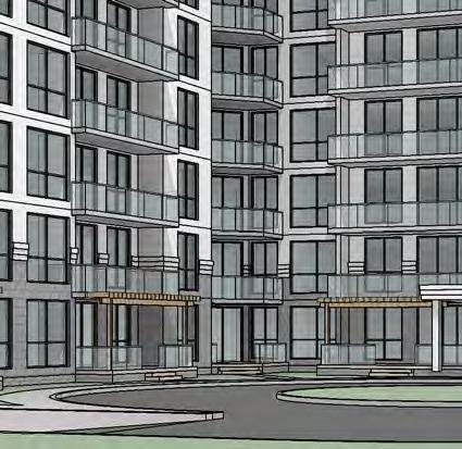
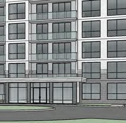
17 Streetscape The L shaped building provides an interesting façade to the public realm exposing the north side of the building and principal entrance fronting onto Commissioners Road West. The building façade has been enhanced in consideration of this visibility. For this reason, the green space along the frontage has been designed with tree, shrub, and perennial plantings to promote a shared streetscape. A 1.5 metre wide walkway from the main entrance provides direct access to the public sidewalk on Commissioners Road. Vehicular access is provided from Commissioners Road. No noise attenuation measures are proposed along the primary collector road. Pedestrian Traffic Areas Public and resident pedestrian traffic to and from the proposed development will be facilitated by concrete hardscapes. The main entrance to the building will be sheltered with a protective canopy / overhang. Access to Sunlight The regulations of the City of London require adequate sunlight for all residential spaces and recreational areas throughout the year. The building will not have significant shadow impact on the adjacent properties. Landscaping Landscape components will be provided in accordance with site plan requirements. The proposed landscaping enhances the overall appearance of the development by softening the edges of the hard materials used in the building façade and paving materials. It also complements existing spaces in nearby properties and the street by using similar plant species and layout. Planting has been used to highlight the pedestrian connection to the streetscape. The plant material is also low maintenance, and tolerant of urban conditions and drought. The central feature within the round-about consists of low maintenance groundcover planting, and a potential water fountain. This focal feature for the site provides visual interest and an enhanced view of the site from the street. The exiting tree line around the perimeter of the site provides privacy for adjacent residential and commercial lands to the east, south and west. As such, no fencing is proposed to retain the existing vegetation. Landscaping specifically provides screening of the service bay, parking lot, and the entrance to the underground parking from existing lands and the street. A common outdoor amenity area has been provided on the south side of the proposed building and is connected to the common building exist. Building Positioning The proposed building has been positioned where appropriate in consideration of setbacks and street-level experience of the site and provides the maximum number of units with a view to Springbank Park. The building orientation has also been done in a way that provides the greatest separation from and opportunity to protect existing mature trees on and around the site. The position of the building is congruent with Official Plan policies and guidelines. bb v:\01614\active\ \planning\report\udb\ _udb_07dec2016.docx 2.3
18 Enhances Accessibility Standards Access and circulation by emergency vehicles will be facilitated as per the site plan. The required ratio of barrier-free parking spaces will also be provided. Sidewalks surrounding the site will enhance pedestrian accessibility and connectivity. It is anticipated that building entrances will be barrier free and sheltered by the overhead balcony. Parking and Loading Internal / underground parking will be provided on site in accordance with the zoning bylaw. The proposed development accommodates accessibility to roads, public transit, bicycle, and walking routes. Loading facilities will be provided as per the Site Plan. Privacy Privacy of residents will be preserved by the building position, underground parking, and strategic landscape plantings, which will act as visual barriers from neighbouring properties. The increased size of balconies at ground level will have slightly tinted glass and large covered trellises to provide more privacy for first storey residents. Outdoor Space/Play Areas/Recreational Facilities With 57% open space area, almost double the zoning requirement, the subject site offers ample outdoor space for passive recreation. A large block of open space area is proposed south of the building, away from traffic and the movement of vehicles accessing the site. Springbank Park is located directly across Commissioners Road West. The park provides a large variety of recreational activities, including by not limited to multi-use trails, benches, play equipment, splash pads, picnic areas, gazebos and Storeybook gardens. Noise Attenuation It is anticipated that transportation noise will be attenuated through building controls. A noise study has been completed as a requirement of Site Plan. Waste Management Waste and materials for recycling will be stored indoors and collected from the west service bay. Resource Conservation The proposed infill development encourages a denser contiguous development in an existing built up area and promotes the efficient use of existing infrastructure. In addition, the development provides for easy access to transit and pedestrian linkages within the Village of Byron. Environmentally sustainable building methods and energy & water resources will be taken into consideration where applicable throughout the design and implementation of the development. 2.4 bb v:\01614\active\ \planning\report\udb\ _udb_07dec2016.docx
19 Gateways The subject site may be considered a gateway location as it is situated along an arterial road, into the Village of Byron. As such, the site provides the opportunity to set a precedent for high quality, urban design The London Plan, 2016 (adopted by City Council) The Draft Official Plan outlines several Directions in the Our Strategy section to give focus and clear path to lead the City to its vision for Direction #5 is to build a mixed-use compact city by promoting strong and consistent growth, directs high intensity mixed-use development in strategic locations, looks inward and upward, plans for infill and intensification, ensures a mix of housing types and more. Direction #7 is to build strong and attractive neighbourhoods for everyone by promoting active living, healthy housing options and social connectedness and designing complete neighbourhoods meeting the needs of all people, placemaking by promoting design that is safe, diverse, walkable, healthy and connected. The City Structure identifies the subject lands as Mainstreet on Map 4 Place Types. The City Building Policies supports and encourages intensification which could be achieved by infill development of vacant and underutilized lots, or redevelopment at a higher than existing density on developed lands, as examples. It is a target of this Plan that a minimum of 45% of all new residential development will be achieved within the Built-Area Boundary of the city. The proposed development is supported by the policies of the draft Official Plan, and will assist with realizing the City s objectives to promote compact form and build complete neighbourhoods The London Plan, 2016 (adopted by City Council) City Design Policies The Draft Official Plan outlines several design policies to give direction to help create pedestrian and transit-oriented environments that integrate planning and land use, develop places and spaces that function effectively and safely, and provides a way in which London will establish its unique identity and set itself apart for other cities. The London Plan s City Design Policies, as outlined under City Building Policies, and with respect to the proposed development, are summarized and discussed below. Additional details regarding site layout, built form, materials and architectural treatment, signage, character and image, massing and articulation, lighting and servicing is provided in Section 3.1. bb v:\01614\active\ \planning\report\udb\ _udb_07dec2016.docx 2.5
20 Neighbourhood Design The proposed development has been designed with the intent of ensuring neighbourhood compatibility through building design, massing, and providing a sense of place. The siting of the buildings, parking and open space areas provide for safety and accessibility for all abilities. Active transportation is supported via 1.5 m sidewalks from the main building to existing sidewalk on Commissioners Road West. Secure bicycle areas are provided on site, and transit stops are located within a short walking distance from the site. The landscape plan provides for a high aesthetic quality and visual screening to adjacent properties. Site Layout The proposed landscape plan and siting of the building will create an aesthetic streetscape along Commissioners Road West. Service areas and loading facilities are located at the west-rear portion of the building where they will not have a negative impact on the street view, nor detract from pedestrian connections to the building. Built Form Built form across the site will be consistent. Entrances will be well-defined and accessible from Commissioners Road West and the parking areas. The site layout provides for an outdoor amenity space on the south portion of the site. Materials The proposed building materials will provide texture and scale, utilize variable materials to break up massing and provide visual interest. Parking Secure bicycle and significant amounts of underground parking is provided on site. Surface parking has been minimized and sited to avoid impacting the frontage where possible. Landscape screenings will provide an aesthetic view into the site. Infrastructure and Utilities The rooftop mechanical room will be screened from view and setback form the front of the roofline. Materials used will blend with the building to minimize visual impact. Signage Signage will be placed for visibility from the public realm and used to introduce the site, demark ingress/egress, and establish sense of place. It will not compromise the safety of pedestrians or motorists by blocking sight lines. 2.6 bb v:\01614\active\ \planning\report\udb\ _udb_07dec2016.docx
21 2.3 SWOT ANALYSIS An analysis of the Strengths, Weaknesses, Opportunities and Threats (SWOT) presented by the neighbourhood context and the proposed development can be summarized as follows: Strengths: The subject lands are currently zoned and designated for the proposed land use. Designed in accordance with the Official Plan policies and urban design guidelines. Supports Official Plan objective to increase compact urban, infill residential housing. Appropriate location for type and scale of development, adjacent to similar-scaled residential developments and contributing to intensification and redevelopment in the Village of Byron. Efficiently uses existing infrastructure and land resources in the City. Adjacent to arterial roads; easily accessible by vehicle, bicycle, and on foot. London transit bus stops are available within 25 metres of the subject site. Built form defines interface between the site and the public realm, and is oriented and massed to create a pedestrian-friendly accessible living space. Building is sited to maximize open views into Springbank Park. Majority of underground parking is below grade to minimize surface parking and maximize open space. Landscape features support the site design intent and mitigate undesirable impacts of development. Close proximity to the Village core and associated amenities and services. Contributes to infill and intensification efforts. Weaknesses: There are no perceived weaknesses, as the site is zoned and designated for the proposed use. Opportunities: Opportunity to contribute to a transit-friendly, compact development with pedestrian linkages to the Village of Byron and Downtown. Opportunities to enhance gateway and establish a new visually appealing development along Commissioners Road West. Provide an appropriate street presence through the use of accepted urban design principles. Opportunities to utilize sustainable techniques and materials to enhance environmental sustainability and set a precedent for future residential developments. Threats: There are no perceived threats at this stage of the development. bb v:\01614\active\ \planning\report\udb\ _udb_07dec2016.docx 2.7
22
23 3.0 CONCEPTUAL DESIGN The overall design objectives for the subject lands are: I. Create a development that is sympathetic to the land uses, both existing and planned, in the neighbourhood and the broader village. II. III. Create a development that will adhere to a high standard of urban design and architectural principles, and complement the vision of the Official Plan for this area by implementing the Urban Design Objectives. Provide well-connected landscape treatment and employ appropriate landscape and architectural design principles to enhance the shared public streetscape. This include but are not limited to maintaining the perimeter trees, minimal site parking, optimizing open views into Springbank Park, The goals outlined above have been achieved throughout the conceptual design process by considering building scale and placement, optimize views into Springbank Park, increase amenity areas and open space through minimal surface parking and provide increased ground floor patio space, transit routes and orientation, inclusion of landscape features, maintaining existing vegetation and perimeter trees, and consideration and support of the public realm. 3.1 SITE DESIGN ELEMENTS Specific conceptual design elements are addressed in the table below, and subsequently in images used as precedents throughout the conceptual design of the subject site. Design Element Site Response Site Design The proposed development is consistent with the Zoning By-law and Official Plan land use designation. The site is located off Commissioners Road West, an arterial road. Building orientation maximizes unit views to Springbank Park and tree retention when considering setbacks, with access off Commissioners Road West. Vehicular and pedestrian corridors are designed for efficient ingress and egress, as bb v:\01614\active\ \planning\report\udb\ _udb_07dec2016.docx 3.1
24 Design Element Site Response well as the circulation of pedestrians through the shared public realm. Public safety has been taken into consideration when designing layout and landscape components of the conceptual site plan. Built Form Built form across the site will be consistent, and appropriately scaled for pedestrians at grade. Building entrances will be well defined and accessible from Commissioners Road West. The mechanical penthouse will be setback and will not be visible from at grade. The mechanical penthouse will be clad in precast concrete matching the upper portion of the building. Massing and Articulation The L shaped building will be massed and oriented parallel to Commissioners Road West to create an aesthetic streetscape. The building will be linked to the public realm by hardscape/concrete sidewalks and provide barrier-free access. Character and Image The overall character and anticipated precedent of the subject site will be in keeping with its designated land use, be compatible with the aesthetic of nearby structures, and be considerate of the shared public realm. Architectural Treatment Details, materials, themes, and colours, etc. contributing to architectural treatment of the proposed building complement and synchronize with the overall architectural character of neighbouring buildings, and in 3.2 bb v:\01614\active\ \planning\report\udb\ _udb_07dec2016.docx
25 Design Element Site Response consideration of the shared public realm and affiliated views. The first three stories will use Arriscraft Renaissance Stone (mimics limestone) and the top four stories will use painted precast concrete panels. The mechanical room will be precast concrete panels that match the building, and will be setback from the perimeter of the building, not visible from eye level. The architectural treatments express a predominant contemporary design, including the profile of the top roof line, with a mix of traditional features such as cornices. The glass balconies at grade will be slightly tinted/fritted to provide privacy for the ground level units. The L shape building provides a visually interesting façade facing Commissioners Road. The balconies and larger surfaces of glass soften the building mass. The materials of walls and treatments at grade are varied to promote interest at a pedestrian scale. Lighting Lighting will be provided where necessary and in accordance with standard guidelines with respect to public safety. Site lighting will be designed to direct to the ground and not to the sky to avoid light pollution. Signage Signage will be strategically and considerately placed for visibility from the public realm and used to introduce the site, bb v:\01614\active\ \planning\report\udb\ _udb_07dec2016.docx 3.3
26 Design Element Site Response demark ingress/egress, and establish sense of place. Servicing Infrastructure necessary to service the site is readily available within the adjacent right-ofway. Internal surface and underground parking will be provided. Public transit is available along two routes within close proximity to the subject property. 3.4 bb v:\01614\active\ \planning\report\udb\ _udb_07dec2016.docx

27 3.2 DESIGN PRECEDENTS Anticipated design of the site layout, architectural elements, and landscaping of the proposed development will reflect existing precedents in Byron and the surrounding community, but will also strive to build on successful elements to create a new design model for future growth in the neighbourhood. Figure 7 Precedent site design elements: 1024 Commissioners Road West Villa Park Place employs modern architectural elements that are sympathetic to the streetscape experience, wide pedestrian corridor, varied paving materials and textures, direct pedestrian circulation, and provide a protective medium for plant material including shade trees, and lowmaintenance shrub / perennial beds. bb v:\01614\active\ \planning\report\udb\ _udb_07dec2016.docx 3.5


28 Figure 8 Precedent architectural and site design elements: 89 Ridout Street The medium density apartment at 89 Ridout Street enhances the building with a corniced roofline, walk-up ground level balconies, contrast building material to stimulate visual interest and a palette of drought-tolerant plant material with year-round attention. A complementary paving pattern provides a visual cue announcing the transition between the public and private realm and contributing to a sense of place. 3.6 bb v:\01614\active\ \planning\report\udb\ _udb_07dec2016.docx
29 4.0 LANDSCAPING The conceptual landscape plan incorporates public and private sidewalk connections from the building to the existing sidewalk along Commissioners Road. Enhanced landscaping will be provided along Commissioners Road, including masonry pillars complete with ornamental fence and mulched planting beds. The masonry pillars adjacent to the driveway will also act as entry features, incorporating nicely finished name and address plaques. Planting has been used to highlight the pedestrian connection to the streetscape. Throughout the site, plant material is low maintenance, tolerant of urban conditions and drought, and will provide year-round interest through colour, foliage, flowers, and texture. The central feature within the round-about consists of low maintenance groundcover planting, and a potential water fountain. This focal feature for the site provides visual interest and an enhanced view of the site from the street. In areas with no canopy or visual buffer to adjacent properties, trees will be planted to increase canopy cover on the site, and to strengthen the existing natural environment. The existing trees along the east, south and west property lines will be retained to provide privacy and screening for adjacent residential and commercial lands. A seating area / common outdoor amenity area has been provided on the south side of the proposed building and is connected directly to the building exist. This amenity space will provide additional space for residents to enjoy. On the west of the building, a mulched planting bed, including ornamental shrubs, groundcover, and ornamental grasses will provide privacy for ground floor residents and screen views to the neighbouring parking lot. Planting of columnar trees adjacent to the service bay will add canopy cover and aesthetic without dominating the narrow space. The trees will also soften views, while maintaining sightlines to promote safety. 5.0 PUBLIC REALM Pedestrian access to the building from the public realm will be facilitated by direct sidewalk connection to Commissioners Road West. Access will be offered to vehicles from Commissioners Road West, and on-site bicycle storage will be provided for residents. bb v:\01614\active\ \planning\report\udb\ _udb_07dec2016.docx 5.1
30
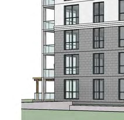
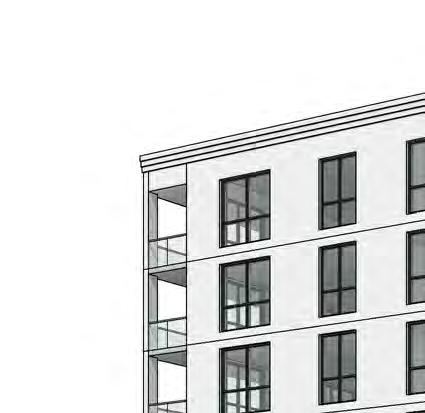
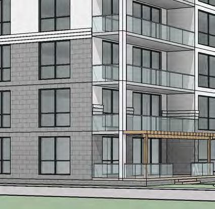
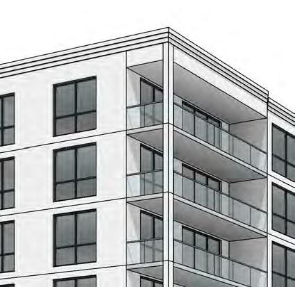
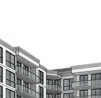
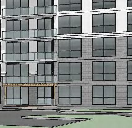
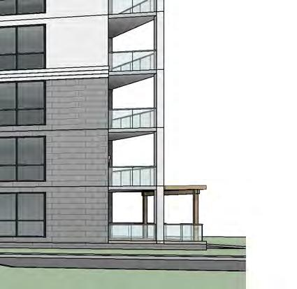
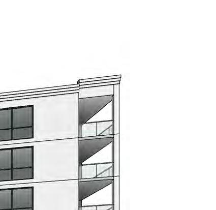
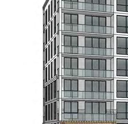
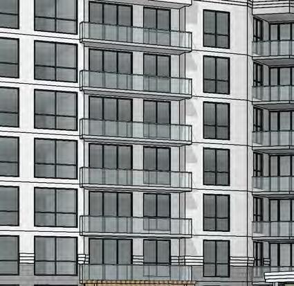
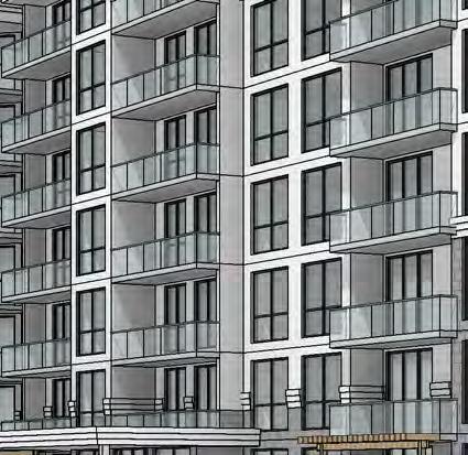
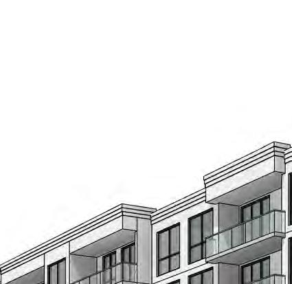
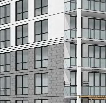
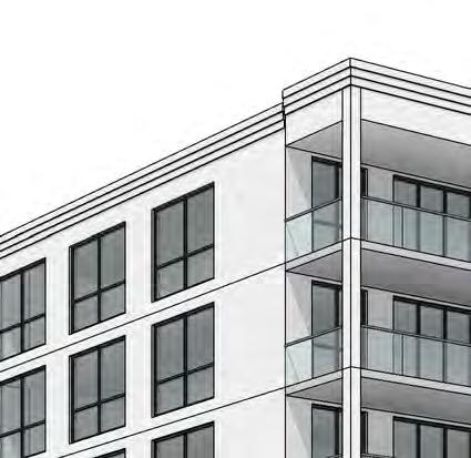
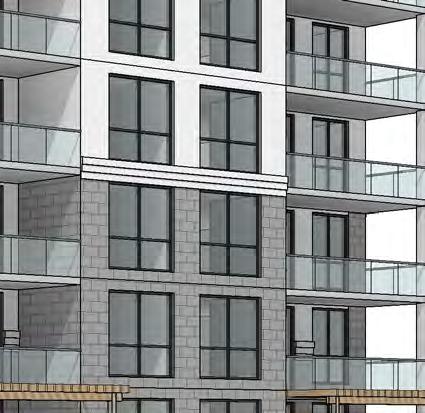
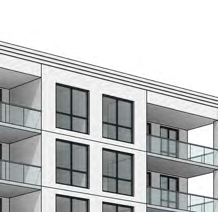
31 6.0 NEIGHBOURHOOD CHARACTER STATEMENT AND COMPATIBILITY STUDY The design of Commissioners Road West is a L shape 7 storey building, with a variety of architectural treatments used to express a combination of contemporary and traditional characteristics that help the building contribute positively to its surrounding context. The first three stories use Arriscraft Renaissance Stone, a precast concrete masonry that mimics limestone; and the top four storeys will use painted light-coloured precast concrete panels. The contrast of the building materials will provide an interesting active face that is friendly and wellportioned relative to the street. The corniced overhang and large glass entrance implies a welcoming and amendable lobby and attractive street level interface. The building creates a datum that is consistent with the adjacent apartments to the east along Commissioners Road. It maintains this datum to complement the context, and create a series of masonry bays, combining contemporary and traditional materials. Additionally, the design exceeds standards while maintaining elements to continue the pattern of the street, thereby enhancing the pedestrian experience along Commissioners Road West. The large glass windows and glass balconies contribute to the contrast of the dark first three storey Arriscraft Renaissance Stone and top four storey light-coloured painted precast panels. White cornices divide the dark stone and white panels along the ends of the building, adding depth and variation. The balconies at ground level will be slightly tinted to provide more privacy for first storey residents. With the roof line and entrance cornices, the contrast of colour and large glass variation, the building design draws visual interest into the site. The height of the building acts as a transitional scale to the existing neighbouring apartments to the east, low density residential homes to the south, and commercial block to the west along Commissioners Road. The combination of contemporary and traditional architectural design results in a building that creates an appealing composition that is both varied and contextual, and aesthetically enhances its surroundings. bb v:\01614\active\ \planning\report\udb\ _udb_07dec2016.docx 6.1
32
33 7.0 SUSTAINABILITY Sustainability measures for the proposed development include strategies listed below (further information regarding sustainability can be found in Appendix C): Transit-friendly compact development with pedestrian linkages to the village core. Installation of drought tolerant plants where feasible. Planting of street trees that will contribute to overall canopy cover. Lighter coloured roofing/siding materials, which reduces cooling costs and urban heat island effect. Low-flow faucets, toilets, and showerheads will be incorporated throughout the units to reduce water consumption. Closed-looped heating and cooling systems. Energy efficient lighting. Recycling and waste management. High efficiency HVAC inside units (individual air handlers with ERV s and unit air conditioner). Individually metered units. Well-constructed building to minimize future maintenance issues. The use of natural light and natural ventilation in the building designs. Utilization of local materials. Site is fully serviced by existing infrastructure. 8.0 CONCLUSION The proposed seven storey apartment buidling will contribute to the quality and character of the Village of Byron, with the intensification and infill on Commissioners Road West; providing a high quality, attractive building; assisting with the enhancement of residential opportunities within the High Density land use per the Official Plan; contributing to a pedestrian-friendly live-work neighbourhood; and enhancing the gateway into Byron by considering landscape and streetscape design elements. bb v:\01614\active\ \planning\report\udb\ _udb_07dec2016.docx 8.1
34


35 9.0 CLOSING This document has been prepared in collaboration with information provided by various Stantec contributors including Project Architect, Michael Votruba, M.Arch, OAA, RAIC, LEED AP, and Landscape Architect, Emily Brown, OALA, CSLA. This information is respectfully submitted in support of the proposed 7 storey (126 unit) apartment building on behalf of the Tricar Group. Sincerely, STANTEC CONSULTING LTD. Andrea McCreery, MCIP, RPP Planner Queens Avenue London ON N6A 5J7 Phone: andrea.mccreery@stantec.com Chris Hendriksen, P.Eng Project Manager Queens Avenue London ON N6A 5J7 Phone: (519) chris.hendriksen@stantec.com bb v:\01614\active\ \planning\report\udb\ _udb_07dec2016.docx 9.1
36
37 SITE PLAN bb v:\01614\active\ \planning\report\udb\ _udb_07dec2016.docx A.1
38


39 N
40 LANDSCAPE PLAN bb v:\01614\active\ \planning\report\udb\ _udb_07dec2016.docx B.1
41
42
43 COMMUNITY ENERGY INITIATIVE bb v:\01614\active\ \planning\report\udb\ _udb_07dec2016.docx C.1
44
45 SITE SUSTAINABILITY OVERVIEW Urban Development Existing and Proposed Trees Site Lighting Alternative Transportation Carbon Dioxide Landscape and Exterior Design Heat Island Infill development and well utilized site close to the downtown Byron core to help contain urban sprawl. Integrates an active pedestrian connection between new and existing development. New trees on site and in the public right of way will contribute to the urban canopy, and new growth will add to the overall rejuvenation of the urban forest. It will provide a pleasant visualization for the existing adjacent buildings, as well as occupants of the proposed. Site lighting will be designed to direct to the ground and not to the sky. The site is adjacent to public transportation routes, pedestrian and cycling networks and has on-site bicycle storage. Future residents will have many active transportation choices, and the site is served by nearby retail and commercial uses within walking distance. The active pedestrian connection provides residents ease of access to Commissioners Road and the Byron commercial/retail core. The design and construction of the building will take into consideration the electrical and natural gas consumption for each major plant and electrical systems. Design will be balanced to provide more efficient equipment. Part of the design exercise will be to target larger electrical loads and the selection of the most efficient solution. The proposed open space area is almost double the zoning requirement, at 56.9%. The landscapes areas will provide for an aesthetically enhanced streetscape, façade and entrance design to the building. The building proposes light-colored building materials which have proven effective in reflecting more light. The roof will use lighter-coloured surfaces compared to a typical asphalt roof, which does not reflect a lot of solar radiation. Exterior Design Through responsible building design, mixes of building materials will be evaluated and selected to decrease the heat island effect and be energy efficient. The design of the new building will be subject to the recently amended Ontario Building Code requirements, particularly by energy modeling design evaluation approach, which largely influences the percentage of glazing, glazing type, building opening s orientation, etc. By the use of a responsible balance of materials and orientation, an energy efficient design will be synergized in an aesthetically pleasing and sustainable structure. C.2 bb v:\01614\active\ \planning\report\udb\ _udb_07dec2016.docx
46 Building Sustainability WATER EFFICIENCY Water Efficient Landscaping Reduced Water Consumption - Domestic Use Reduced Water Consumption - Heating & Cooling ENERGY & ATMOSPHERE Design Features Mechanical Systems Design Features Electrical Electrical Metering and Controls The building design, materials, and equipment have been selected and will be incorporated such that the building is sustainable in the long term. Sections of window walls will be designed in compartments to reduce the overall large expansion and contraction properties attributed with glass. The use of precast exterior wall panels and coating provides improved life cycle façade with minimal fading or delamination as found in other materials. Drought resistant landscape material will be specified as much as possible. Low-flow faucets, toilets, and showerheads will be incorporated throughout the units to reduce water consumption. The intent is for hot water domestic supply to come via condensing boiler systems. Heated storage tanks will be utilized to reduce fluctuations in the requirement for hot water under peak demand. Allowing for on-site storage reduces the amount of time required by residents to wait for hot water to come from centralized systems. Through the integration of a chiller and condensing boilers, the heating and cooling systems will be completely closed looped systems. The evaporation losses and energy efficiencies will be minimalized, even more than a conventional heating and cooling system. The buildings HVAC system is centralized, individual controls will be provided in units for heating, cooling and lighting. The use of condensing boilers will be installed. Variable speed pumps for heating and cooling will be incorporated with integrated building controls. Energy efficient lighting will be utilized throughout the building. High efficiency florescent lighting will be utilized in most common areas which require 100% illumination at all time (parking garage, corridors, and stairs), and consideration for motion detection devices and/or LED lighting will be taken into consideration. Natural light is accommodated in all units and common areas to reduce the need for electrical consumption. Energy efficient appliances will be the standard inclusion for all units. Utilities will be separately metered for individual units making residents aware of energy consumption. The building manager will be responsible for common areas and to monitor and reduce energy consumption. Common areas to be separately metered for electrical and natural gas. bb v:\01614\active\ \planning\report\udb\ _udb_07dec2016.docx C.3
47 MATERIALS & RESOURCES Regional Materials Low Emitting Materials Collection of Recyclables Building Materials Construction Waste Management The vast majority of materials are available locally (800km radius as defined in LEED standard), limiting environmental impact of source supply transportation. Low VOC materials will be used where possible, including, membranes, soy based polyurethane insulation, paints, carpeting, etc. Collection of recyclables will be in accordance with City by-laws. A collection room will be located in the base of the building with ample room for additional bins. High recycled content material to be specified where possible. Renewable finishes (such as flooring) will be offered as choices to purchasers of residential units. A construction waste diversion program will be in effect during the construction period. On-site concrete washing out will not be done on-site, back washing of the concrete truck will be done at the batching plant. INDOOR ENVIRONMENT QUALITY System Controllability Each unit will have access to individual controls for heating, cooling, lighting, and ventilation. Natural Ventilation Operatable windows are provided for every unit and individual balcony. Low VOC emitting Materials Low VOC materials will be utilized where possible. Natural Light The building provides natural light to all regularly utilized spaces, other than the below grade parking garage. INNOVATION & DESIGN PROCESS Sustainable Consultants The building and units will be designed and developed with input from accredited sustainable consultants. The building will be constructed to SB10 of the Ontario Building Code, energy modeling will be completed and applied to the building design to exceed the requirements of SB10. C.4 bb v:\01614\active\ \planning\report\udb\ _udb_07dec2016.docx
48
49 ELEVATIONS bb v:\01614\active\ \planning\report\udb\ _udb_07dec2016.docx D.1
50

51 1202 Commissioners Road - DRAFT 1 00 View of Lobby Entrance London, ON November 2016

52 1202 Commissioners Road - DRAFT 1 01 View from Commissioners Road London, ON November 2016


53 TOP OF PENTHOUSE 85' - 6" ROOF 73' - 0" 7th FLOOR 61' - 0" 6th FLOOR 50' - 10" 5th FLOOR 40' - 8" 4th FLOOR 30' - 6" 3rd FLOOR 20' - 4" 2nd FLOOR 10' - 2" GROUND FLOOR GRADE 0' - 0" -1' - 6" 1202 Commissioners Road - DRAFT 1 02 North Elevation London, ON November 2016


54 TOP OF PENTHOUSE 85' - 6" ROOF 73' - 0" 7th FLOOR 61' - 0" 6th FLOOR 50' - 10" 5th FLOOR 40' - 8" 4th FLOOR 30' - 6" 3rd FLOOR 20' - 4" 2nd FLOOR 10' - 2" GROUND FLOOR GRADE 0' - 0" -1' - 6" 1202 Commissioners Road - DRAFT 1 03 East Elevation London, ON November 2016


55 TOP OF PENTHOUSE 85' - 6" ROOF 73' - 0" 7th FLOOR 61' - 0" 6th FLOOR 50' - 10" 5th FLOOR 40' - 8" 4th FLOOR 30' - 6" 3rd FLOOR 20' - 4" 2nd FLOOR 10' - 2" GROUND FLOOR GRADE 0' - 0" -1' - 6" 1202 Commissioners Road - DRAFT 1 04 South Elevation London, ON November 2016


56 TOP OF PENTHOUSE 85' - 6" ROOF 73' - 0" 7th FLOOR 61' - 0" 6th FLOOR 50' - 10" 5th FLOOR 40' - 8" 4th FLOOR 30' - 6" 3rd FLOOR 20' - 4" 2nd FLOOR 10' - 2" GROUND FLOOR GRADE 0' - 0" -1' - 6" 1202 Commissioners Road - DRAFT 1 05 West Elevation London, ON November 2016
Urban Design Brief. 27 Centre Street London, ON. Prepared for: The Escalade Property Corp. Box 37 Lambeth Station London ON N6P 1P9
 Urban Design Brief 27 Centre Street London, ON Prepared for: The Escalade Property Corp. Box 37 Lambeth Station London ON N6P 1P9 Prepared by: Stantec Consulting Ltd. 600-171 Queens Avenue London, ON N6A
URBAN DESIGN BRIEF 305, 309, & 315 SOUTHDALE ROAD WEST LONDON ONTARIO
 URBAN DESIGN BRIEF 305, 309, & 315 SOUTHDALE ROAD WEST LONDON ONTARIO CARVEST PROPERTIES LTD. December 2013 Section 1 - Land Use Planning Context 1.1 Subject Lands The subject lands are located immediately
Planning Justification Report for 644 & 646 Huron Street London ON Zoning By-law Amendment Prepared for: Jose Pinhal 665 Kipps Lane London ON N6P 1H
 Planning Justification Report for 644 & 646 Huron Street London ON Zoning By-law Amendment Prepared for: Jose Pinhal 665 Kipps Lane London ON N6P 1H Prepared by: Luis Claro 67 Edgevalley Rd London ON N5Y
URBAN DESIGN BRIEF URBAN DESIGN BRIEF 721 FRANKLIN BLVD, CAMBRIDGE August 2018
 URBAN DESIGN BRIEF URBAN DESIGN BRIEF 721 FRANKLIN BLVD, CAMBRIDGE August 2018 DESIGN BRIEF CONTENTS PART A 1.0 INTRODUCTION 2.0 DESCRIPTION & ANALYSIS OF SITE CONTEXT 3.0 DESIGN CONSTRAINTS AND OPPORTUNITIES
Planning Justification Report for 505 Talbot Street London ON
 Planning Justification Report for 505 Talbot Street London ON Zoning By-law Amendment Prepared for: 505 Talbot Limited 3800 Colonel Talbot Road London ON N6P 1H5 Prepared by: Stantec Consulting Ltd. 600-171
Urban Design Brief 1576 Richmond Street City of London
 Urban Design Brief City of London Treadstone Developments October 31, 2014 Urban Design Brief October 31, 2014 TABLE OF CONTENTS Page No. INTRODUCTION... 1 SECTION 1 LAND USE PLANNING CONCEPT... 1 1.1
Urban Design Brief December 23, 2015 Southside Construction Group Official Plan & Zoning By-Law Amendment
 Urban Design Brief Proposed Official Plan & Zoning By-Law Amendment 3244, 3263 and 3274 Wonderland Road South Southside Group December 23, 2015 TABLE OF CONTENTS Page No. INTRODUCTION... 1 SECTION 1 LAND
Bel-Air Lexus Automobile Service Station
 Bel-Air Lexus Automobile Service Station Design Brief 443-447 McArthur Avenue Ottawa April 30, 2015 14-1299-MCA Site Details Application: Site Plan Control Legal Description and Municipal Addresses: 443
TABLE OF CONTENTS 1.0 INTRODUCTION... 3
 TABLE OF CONTENTS 1.0 INTRODUCTION... 3 1.1. BACKGROUND... 3 1.2. THE PROPOSAL... 5 2.0 EXISTING POLICY FRAMEWORK... 5 2.1. PROVINCIAL POLICY STATEMENT (PPS)... 5 2.2. CITY OF LONDON OFFICIAL PLAN (OP)...
Urban Design Brief Woodland Cemetery Funeral Home 493 Springbank Drive
 Urban Design Brief Woodland Cemetery Funeral Home The Incorporated Synod of the Diocese of Huron April 15, 2016 Urban Design Brief April 15, 2016 TABLE OF CONTENTS Page No. INTRODUCTION... 1 SECTION 1
Urban Design Brief. Watson Parkway North & Watson Road North Guelph, Ontario. Prepared by Coletara Development
 Urban Design Brief Watson Parkway North & Watson Road North Guelph, Ontario Prepared by Coletara Development December, 2013 Urban Design Brief, Coletara Development 1 Introduction This Urban Design Brief
New-Cast Mixed-use Development Proposal King Street West, Newcastle, Ontario
 URBAN DESIGN BRIEF New-Cast Mixed-use Development Proposal King Street West, Newcastle, Ontario TABLE OF CONTENTS: 1.0 Executive Summary 2.0 Creating Vibrant and Sustainable Urban Places: Excerpts from
Urban Design Brief. 583, 585 and 589 OXFORD STREET EAST. Salt Clinic Canada Inc.
 Urban Design Brief 583, 585 and 589 OXFORD STREET EAST Salt Clinic Canada Inc. February 3, 2013 TABLE OF CONTENTS Page No. INTRODUCTION... 1 SECTION 1 LAND USE PLANNING CONCEPT... 1 1.1 The Subject Property...
East Bayshore Road Neighbourhood
 East Bayshore Road Neighbourhood Northridge Property Management Urban Design Brief 3195 East Bayshore Road City of Owen Sound January 2016 East Bayshore Road Neighbourhood Northridge Property Management
Urban Design Brief to 1557 Gordon Street & 34 Lowes Road West
 Urban Design Brief 1533 to 1557 Gordon Street & 34 Lowes Road West Reid s Heritage Homes Ltd. & 883928 Ontario Ltd. and RHH Property Management Ltd. City of Guelph Zoning By-law Amendment November 2017
ELMVALE ACRES SHOPPING CENTRE MASTER PLAN
 ELMVALE ACRES SHOPPING CENTRE MASTER PLAN Contents 1.0 INTRODUCTION... 2 2.0 LOCATION... 2 3.0 EXISTING CONTEXT... 2 4.0 VISION & GUIDING PRINCIPLES... 2 5.0 LAND USE AND BUILT FORM... 4 5.1 St. Laurent
Urban Design Brief Fanshawe Park Road. Competition Toyota
 Urban Design Brief 1300 Fanshawe Park Road Competition Toyota May 2, 2014 TABLE OF CONTENTS Page No. INTRODUCTION... 1 SECTION 1 LAND USE PLANNING CONTEXT... 1 1.1 The Subject Lands... 1 1.2 The Proposal...
URBAN DESIGN BRIEF. 2136&2148 Trafalgar Road. Town of Oakville
 URBAN DESIGN BRIEF 2136&2148 Trafalgar Road Town of Oakville Prepared By: METROPOLITAN CONSULTING INC For 2500674 Ontario Inc November 2016 TABLE OF CONTENTS Page No. 1.0 Introduction/Description of Subject
Highland Village Green Design Guidelines
 Highland Village Green Design Guidelines Publishing Information Title Highland Village Green Design Guidelins Author The City of Calgary Status DRAFT - Proposed document subject to changes Additional Copies
FRUITVALE TRANSIT VILLAGE (Phase 2) Residential Project
 Residential Project") FRUITVALE TRANSIT VILLAGE (Phase 2) Residential Project DEVELOPER: SIGNATURE PROPERTIES ARCHITECT: HKIT ARCHITECTS April 23, 2010 TABLE OF CONTENTS 3 Vision 4 Description of Site 5 Guiding Concepts 6
FRUITVALE TRANSIT VILLAGE (Phase 2) Residential Project DEVELOPER: SIGNATURE PROPERTIES ARCHITECT: HKIT ARCHITECTS April 23, 2010 TABLE OF CONTENTS 3 Vision 4 Description of Site 5 Guiding Concepts 6
Urban Design Brief 32, 36 and 40 York Street City of London
 Urban Design Brief 32, 36 and 40 York Street City of London 161413372 Prepared for: Tricar Developments Inc. Prepared by: Stantec Consulting & Kasian Architecture Ontario Inc. July 18, 2017 URBAN DESIGN
URBAN DESIGN BRIEF Gordon Street City of Guelph. Prepared on behalf of Ontario Inc. March 25, Project No. 1507
 URBAN DESIGN BRIEF 1131 Gordon Street City of Guelph Prepared on behalf of 1876698 Ontario Inc. March 25, 2016 Project No. 1507 423 Woolwich Street, Suite 201, Guelph, Ontario, N1H 3X3 Phone (519) 836-7526
URBAN DESIGN BRIEF 181 Burloak Drive, Oakville
 URBAN DESIGN BRIEF 181 Burloak Drive, Oakville February 2017 Our File: 1730B 230-7050 WESTON ROAD / WOODBRIDGE / ONTARIO / L4L 8G7 / T: 905 761 5588/ F: 905 761 5589/WWW.MHBCPLAN.COM TABLE OF CONTENTS
Tel: (705) Fax: (705)
 Fax: (705)") 521 and 525 Essa Road City of Barrie Tel: (705) 812-3281 Fax: (705) 812-3438 Email: INFO@IPSCONSULTINGINC.com 1 5 0 D U N L O P S T R E E T E A S T, S U I T E 2 0 1, B A R R I E O N T A R I O L 4 M 1 B
521 and 525 Essa Road City of Barrie Tel: (705) 812-3281 Fax: (705) 812-3438 Email: INFO@IPSCONSULTINGINC.com 1 5 0 D U N L O P S T R E E T E A S T, S U I T E 2 0 1, B A R R I E O N T A R I O L 4 M 1 B
Westwind Developments Ltd. PIONEER LANDS AREA STRUCTURE PLAN - PROPOSED AMENDMENT
 FEBRUARY 2013 TABLE OF CONTENTS 1.0 BACKGROUND... 1 1.1 Amendment... 1 2.0 LOCATION & CONTEXT... 2 2.1 Land Ownership... 2 3.0 POLICY CONTEXT... 3 3.1 Municipal Development Plan... 3 3.2 Capital Region
URBAN DESIGN BRIEF REPORT
 URBAN DESIGN BRIEF REPORT PREPARED FOR 2568401 ONTARIO INC NEW GASBAR, CONVENIENCE STORE & CARWASH DEVELOPMENT @ 1509 FANSHAWE PARK ROAD WEST LONDON, ONTARIO GAMA ENGINEERING INC. PROJECT NUMBER 1669 PREPARED
178 Carruthers Properties Inc.
 178 Carruthers Properties Inc. Planning Rationale for 178 Carruthers Avenue Site Plan Control Application June 2014 Table of Contents 1.0 Introduction 2.0 Overview of Subject Property 3.0 Current Zoning
Policies and Code Intent Sections Related to Town Center
 Policies and Code Intent Sections Related to Town Center The Town Center Vision is scattered throughout the Comprehensive Plan, development code and the 1994 Town Center Plan. What follows are sections
420 FANSHAWE PARK ROAD EAST London, ON
 420 FANSHAWE PARK ROAD EAST London, ON URBAN DESIGN BRIEF, CHARACTER STATEMENT & COMPATIBILITY REPORT April 2016 Prepared by MHBC Planning 630 COLBORNE STREET SUITE 202 LONDON, ON N6B 2V2 TABLE OF CONTENTS
Urban Design Manual 2.0 DRIVE-THROUGH FACILITIES. Background. Urban Design Challenges
 222221 2.0 DRIVE-THROUGH FACILITIES Background In recent years, drive-through facilities have grown significantly in popularity with drive-through restaurants, in particular, being established on numerous
DRAFT Northeast Quadrant of Kipling Avenue and Highway 7 DRAFT AUGUST 29, Goals Land Use. The goals of this Plan are to:
 AUGUST 29, 2017 12.15 Northeast Quadrant of Kipling Avenue and Highway 7 12.15.1 Goals 12.15.2 Land Use The goals of this Plan are to: 12.15.2.1 General Provisions: a) Ensure the development of a compact
URBAN DESIGN BRIEF NORTHVIEW FUNERAL HOME HIGHBURY AVE N, LONDON, ON
 URBAN DESIGN BRIEF NORTHVIEW FUNERAL HOME - 1490 HIGHBURY AVE N, LONDON, ON 1.1Purpose The intent of the following report is to identify an opportunity for redevelopment of two residential properties within
Regency Developments. Urban Design Brief. Holyrood DC2 Rezoning
 Regency Developments Urban Design Brief Holyrood DC2 Rezoning Stantec Consulting Ltd. 7-31-2017 1. Overview Regency Developments intends to rezone the lands located at 8510 and 8511 93 Avenue, within the
GUIDELINES REPLACEMENT HOUSING GUIDELINES LOCATION INTRODUCTION URBAN DESIGN GUIDELINES
 Replacement housing in the former City of North York will be consistent with the following urban design guidelines. They provide a framework for residential re-development in the former City of North York
New Street Proposed Redevelopment Architecture & Urban Design Brief
 2130 2136 New Street Proposed Redevelopment Architecture & Urban Design Brief Prepared By: Cynthia Zahoruk Architect Inc. 3077 New Street, Burlington, ON, L7N 1M6 TABLE OF CONTENTS Background and Objective
4.0 Design Guidelines For The Village Centre. South fields Community Architectural Design Guidelines Town of Caledon
 4.0 Design Guidelines For The Village Centre 4.0 Design Guidelines for the Village Centre The Village Centre is the focal point of the entire South Fields Community and is designed as a traditional commercial
WEST LOOP DESIGN GUIDELINES CHECKLIST
 WEST LOOP DESIGN GUIDELINES CHECKLIST Section 1.0 General Strategies 1.1 DESIGN EXCELLENCE: ENCOURAGE HIGH QUALITY AND INNOVATIVE DESIGN OF NEW BUILDINGS WITHIN THE WEST LOOP WITHOUT BEING PRESCRIPTIVE
URBAN DESIGN BRIEF. April FREEPORT Street TOWNHOUSES. 711 FREEPORT St., LONDON
 URBAN DESIGN BRIEF April 2013 FREEPORT Street TOWNHOUSES 711 FREEPORT St., LONDON TABLE OF CONTENTS 1.0 Land Use Planning Context...... pg. 1 1.1 Subject Lands... pg. 1 1.2 Proposed Development... pg.
(DC1) Direct Development Control Provision DC1 Area 4
 Direct Development Control Provision DC1 Area 4") . General Purpose (DC) Direct Development Control Provision DC Area 4 The purpose of this Provision is to provide for an area of commercial office employment and residential development in support of the
. General Purpose (DC) Direct Development Control Provision DC Area 4 The purpose of this Provision is to provide for an area of commercial office employment and residential development in support of the
CONTENTS 8.0 LAND USE 8.1 GENERAL LAND USE 8.2 RESIDENTIAL 8.3 MIXED USE 8.4 COMMERCIAL 8.5 EMPLOYMENT LANDS
 8-2 Land Use 8.0 LAND USE CONTENTS 8.1 GENERAL LAND USE 8.1.1 Uses provided for in all Land Use Designations 8.1.2 Uses prohibited in Hazardous Lands, Hazardous Sites and Special Policy Areas 8.1.3 Uses
Clairtrell Area Context Plan
 Clairtrell Area Context Plan March 2005 Urban Development Services City Planning Contents 1. Introduction... 4 2. Development Structure... 6 2.1 Streets... 7 2.1.1 Sheppard Avenue and Bayview Avenue...
KEY MAP DEVELOPMENT PERMIT AREA MAP. Sunnymede North Sub-Area Plan
 Richmond Official Community Plan BROADMOOR AREA SUNNYMEDE NORTH SUB-AREA PLAN Bylaw 7100 Schedule 2.6C SUNNYMEDE NORTH SUB-AREA PLAN SUNNYMEDE NORTH SUB-AREA PLAN SUNNYMEDE NORTH SUB-AREA PLAN KEY MAP
Housing and Coach House Guidelines - Ladner
 Housing and Coach House Guidelines - Ladner Policy D.8: Encourage Compatible Housing Design Encourage housing design that is sensitive to existing single family housing neighbourhoods by requiring a design
EXISTING COMPREHENSIVE PLAN
 EXISTING COMPREHENSIVE PLAN Town Center Land Use Element: V. LAND USE POLICIES Town Center Mercer Island's business district vision as described in "Your Mercer Island Citizen-Designed Downtown" was an
Commercial Development Permit Area
 City of Kamloops KAMPLAN Commercial Development Permit Area PURPOSE The purpose of this Development Permit Area (DPA) is to establish objectives and provide guidelines for the form and character of commercial
URBAN DESIGN BRIEF. Terms of Reference. Purpose. When is an Urban Design Brief Required
 Purpose An Urban Design Brief (UDB) is intended to describe and illustrate proposed designs for new development projects and demonstrate how the City s Urban Design Guidelines and other City policies have
5.1 Site Plan Guidelines
 5. Community Core Guidelines Development of the Community Core will take place by plan of subdivision and site plan approval. It will occur in a phased manner that will reflect the timing of residential
URBAN DESIGN BRIEF 1435 Beaverbrook Road On behalf of Wonderland Commercial Centre Inc.
 URBAN DESIGN BRIEF 1435 Beaverbrook Road On behalf of Wonderland Commercial Centre Inc. Knutson Development Consultants Inc. Development Engineering (London) Ltd. K & L Construction and Arthur Lierman
4. INDUSTRIAL 53 CASTLE ROCK DESIGN
 4. INDUSTRIAL 53 CASTLE ROCK DESIGN CASTLE ROCK DESIGN 54 4. INDUSTRIAL Overview Well-designed and attractive industrial centers are the product of blending economic realities with both functional and
KANATA CENTRUM 255 KANATA AVENUE OFFICIAL PLAN AMENDMENT ZONING BY-LAW AMENDMENT
 KANATA CENTRUM 255 KANATA AVENUE OFFICIAL PLAN AMENDMENT ZONING BY-LAW AMENDMENT JUNE 2015 PREPARED BY: FOTENN Consultants Inc. 223 Mcleod Street Ottawa, ON K2P OZ8 (613) 730-5709 PREPARED FOR: Kanata
Community Design Plan
 Gardena General Plan 2006 Authority While the is not a required element of a General Plan, it is included because improving the community appearance and image is paramount to the overall quality of life
Urban Design Guidelines Townhouse and Apartment Built Form
 Urban Design Guidelines Townhouse and Apartment Built Form Town of Wasaga Beach Table of Contents 1. Introduction 1.1. Purpose 1.2. Urban Design Principles 1.3. Application of Guidelines 2. Site Design,
Gas Stations ottawa.ca
 Urban Design Guidelines for Gas Stations ottawa.ca Ce document est disponible en français sur ottawa.ca. This document is available in French on ottawa.ca. Approved by City Council May 24, 2006 City of
Urban Design Brief Proposed Residential Development 5219 Upper Middle Road City of Burlington
 Urban Design Brief Proposed Residential Development 5219 Upper Middle Road City of Burlington Prepared by Weston Consulting Prepared for BLOOMFIELD DEVELOPMENT INC. Date: March 2017 Table of Contents 1.
lot flankage Y street 16m 6m landscape strip for large site 3m landscape strip for small medium site
 Commercial General Commercial Objectives Create developments compatible with adjacent land uses in scale, function and character Define a consistent and attractive street edge with quality landscaping,
URBAN DESIGN BRIEF. Saginaw Subdivision 124 SAGINAW PARKWAY, CAMBRIDGE OCTOBER 2015 OUR FILE 1422A
 URBAN DESIGN BRIEF Saginaw Subdivision 124 SAGINAW PARKWAY, CAMBRIDGE OCTOBER 2015 OUR FILE 1422A Contents 1.0 INTRODUCTION AND SITE DESCRIPTION... 1 2.0 MUNICIPAL DESIGN DIRECTION... 7 3.0 MASTER CONCEPT
B L A C K D I A M O N D D E S I G N G U I D E L I N E S for Multi-family Development
 B L A C K D I A M O N D D E S I G N G U I D E L I N E S for Multi-family Development Adopted June 18, 2009 This section of the Design and focuses on site planning and design guidance for new multi-family
Lehigh Acres Land Development Regulations Community Planning Project
 Lehigh Acres Land Development Regulations Planning Effort Summary In July, 2010 Commissioner Frank Mann invited the Lehigh Acres community to start discussing how to achieve their recently adopted community
AIRPORT BUSINESS PARK
 PIER MAC PETROLEUM INSTALLATION LTD. AIRPORT BUSINESS PARK DEVELOPMENT APPLICATIONS March 2003 4.1 Airport Business Park Development Permit Area 4.1.1 Justification/Design Concept The design concept envisioned
[PLANNING RATIONALE] For Site Plan Control and Lifting of Holding Zone By-Law 101 Champagne Avenue. May 23, 2014
![[PLANNING RATIONALE] For Site Plan Control and Lifting of Holding Zone By-Law 101 Champagne Avenue. May 23, 2014](/thumbs/75/71599615.jpg "[PLANNING RATIONALE] For Site Plan Control and Lifting of Holding Zone By-Law 101 Champagne Avenue. May 23, 2014") [PLANNING RATIONALE] For Site Plan Control and Lifting of Holding Zone By-Law 101 Champagne Avenue May 23, 2014 Contents 1.0 Introduction... 2 2.0 Site Context... 2 2.1 Adjacent Uses... 2 Figure 1: Site
[PLANNING RATIONALE] For Site Plan Control and Lifting of Holding Zone By-Law 101 Champagne Avenue May 23, 2014 Contents 1.0 Introduction... 2 2.0 Site Context... 2 2.1 Adjacent Uses... 2 Figure 1: Site
REPORT TO THE CHIEF ADMINISTRATIVE OFFICER FROM THE DEVELOPMENT AND ENGINEERING SERVICES DEPARTMENT
 REPORT TO THE CHIEF ADMINISTRATIVE OFFICER FROM THE DEVELOPMENT AND ENGINEERING SERVICES DEPARTMENT ON REZONING APPLICATION NO. REZ00587 DEVELOPMENT PERMIT APPLICATION NO. DPM00559 1430 SUMMIT DRIVE OWNER/APPLICANT:
STAFF REPORT TO COUNCIL PLANNING AND DEVELOPMENT
 DATE: April 29, 2013 STAFF REPORT TO COUNCIL PLANNING AND DEVELOPMENT 1100 Patricia Boulevard, Prince George, B.C., V2L 3V9 TO: FROM: SUBJECT: MAYOR AND COUNCIL JESSE DILL, PLANNER Development Variance
WINDSOR GLEN DESIGN GUIDELINES
 WINDSOR GLEN DESIGN GUIDELINES Adopted by Council, 2006 WINDSOR GLEN REDEVELOPMENT DESIGN GUIDELINES August 2006 1.0 Master Plan Organization For this area of the Coquitlam Town Centre, a mix of high,
Multi family Residential Development Permit Area
 City of Kamloops KAMPLAN Multi family Residential Development Permit Area PURPOSE The purpose of this Development Permit Area (DPA) is to establish objectives and provide guidelines for the form and character
Complete Neighbourhood Guidelines Review Tool
 Complete Neighbourhood Guidelines Review Tool Prepared By: City of Regina Planning Department October 2014 Page 1 of 14 Community Development Review Checklist for Secondary Plans and Concept Plans The
Urban Design Brief. Garden Drive Townhouse Development Matas Development Group. Oakville, Ontario
 Garden Drive Townhouse Development Matas Development Group Oakville, Ontario February 8, 2013 Urban Design and Architecture 2 Introduction This Urban Design Brief has been prepared in support of a rezoning
1.0 Purpose of a Secondary Plan for the Masonville Transit Village
 Report to Planning and Environment Committee To: Chair and Members Planning & Environment Committee From: John M. Fleming Managing Director, Planning and City Planner Subject: Masonville Transit Village
Urban Design Manual PLANNING AROUND RAPID TRANSIT STATIONS (PARTS) Introduction. Station Study Areas
 Introduction. Station Study Areas") 111111 PLANNING AROUND RAPID TRANSIT STATIONS (PARTS) Introduction The ION rapid transit system will link Waterloo, Kitchener and Cambridge through a central transit corridor (CTC). There are a number
111111 PLANNING AROUND RAPID TRANSIT STATIONS (PARTS) Introduction The ION rapid transit system will link Waterloo, Kitchener and Cambridge through a central transit corridor (CTC). There are a number
Future Five. Design/ Development Guidelines. January 2008 Amended June 08 per City Council motion
 Future Five Design/ Development Guidelines January 2008 Amended June 08 per City Council motion 5-Points Design Guidelines Table of Contents I. Introduction 3 II. Area boundaries 4 III. Review Process
Mark-up of the effect of the proposed Bronte Village Growth Area OPA No.18 on the text of section 24, Bronte Village, of the Livable Oakville Plan
 Mark-up of the effect of the proposed Bronte Village Growth Area OPA No.18 on the text of section 24, Bronte Village, of the Livable Oakville Plan Notes: This document is provided for information purposes
Planning Justification Report for 1888 Gordon Street Guelph, Ontario
 Planning Justification Report for 1888 Gordon Street Guelph, Ontario 161401285 Prepared for: The City of Guelph on behalf of Tricar Developments Inc. 3800 Colonel Talbot Road London ON N6P 1H5 Prepared
DEVELOPMENT CONTROLS MEDICAL DISTRICT
 6.01. GENERAL DESIGN GUIDELINES A. Site Planning B. Architectural Design C. Medical Facility Signage & Lighting D. Exhibit 48. ARCHITECTURAL DESIGN CONCEPTS 6.02. MEDICAL FACILITY STANDARDS & GUIDELINES
*** DRAFT 2 FOR PUBLIC REVIEW ***
 6.7 The area is generally bounded by the Red Hill Valley Parkway to the west, Lake Avenue to the east, the Queen Elizabeth Way (QEW) to the north, and by the properties just south of Queenston Road to
Community Mixed Use Zone Districts (CMU)
") 18.28.500 Community Mixed Use Zone Districts (CMU) The Community Mixed Use Zone Districts (CMU) are intended to help implement the land use goals and strategies found in the Golden Vision 2030 values,
18.28.500 Community Mixed Use Zone Districts (CMU) The Community Mixed Use Zone Districts (CMU) are intended to help implement the land use goals and strategies found in the Golden Vision 2030 values,
Wide asphalt driveway abutting school property. garage built with incompatible materials, too close to park. incompatible fencing materials
 Wide asphalt driveway abutting school property incompatible fencing materials garage built with incompatible materials, too close to park Lack of plantings as a buffer between private property and open
DRAFT. 10% Common Open Space
 % OF CHARLOTTE IS CATEGORIZED AS A. LAND USES : Placeholder map displaying location of Place Type GOALS: Accommodate XX% of future growth. Provide a concentration of primarily commercial and civic activity
FLORIN ROAD CORRIDOR Site Plan and Design Review Guidelines Checklist
 FLORIN ROAD CORRIDOR Site Plan and Design Review Guidelines Checklist Applicant s Name: Project Address: Phone: Email: Applicant shall fill out the design guidelines checklist for all guidelines applicable
141 GEORGE STREET PLANNING RATIONALE
 141 GEORGE STREET PLANNING RATIONALE MINOR ZONING BY-LAW AMENDMENT NOVEMBER 2, 2016 PLANNING RATIONALE 223 McLeod Street Ottawa, ON K2P 0Z8 613.730.5709 fotenn.com INTRODUCTION FOTENN Consultants is acting
89-97 KING STREET London, ON URBAN DESIGN BRIEF DECEMBER 2016 (REVISED: FEBRUARY 2017)
") 89-97 KING STREET London, ON URBAN DESIGN BRIEF DECEMBER 2016 (REVISED: FEBRUARY 2017) Prepared by MHBC Planning 630 COLBORNE STREET SUITE 202 LONDON, ON N6B 2V2 Section 1 TABLE OF CONTENTS 1.1 Introduction
89-97 KING STREET London, ON URBAN DESIGN BRIEF DECEMBER 2016 (REVISED: FEBRUARY 2017) Prepared by MHBC Planning 630 COLBORNE STREET SUITE 202 LONDON, ON N6B 2V2 Section 1 TABLE OF CONTENTS 1.1 Introduction
AMENDMENT NO. 42 TO THE OFFICIAL PLAN OF THE TOWN OF GRIMSBY
 AMENDMENT NO. 42 TO THE OFFICIAL PLAN OF THE TOWN OF GRIMSBY INITIATED BY TOWN OF GRIMSBY TABLE OF CONTENTS PART I: THE CERTIFICATION Certification Page Adopting By-law of the Town of Grimsby PART II:
Toronto Complete Streets Guidelines
 Toronto Complete Streets Guidelines 108 110 7.1 Green Infrastructure Design Principles 112 7.2 Context-Sensitive Green Streets 114 7.3 Key Green Street Elements Green infrastructure refers to natural and
Design Guidelines - 1 -
 Design Guidelines REAR YARDS Rear yard decks and porches, attached to a garden or garage suite, should be permitted provided minimum rear yard setbacks, separation distances, and necessary site access
Re: 1110 Fisher Avenue Proposed Residential Development Revised Proposal File D PLANNING RATIONALE ADDENDUM
 October 23, 2014 Prestige Design & Construction 50 Camelot Drive Ottawa, ON K2G 5X8 Attention: Mr. Enzo DiChiara Dear Mr. DiChiara Re: 1110 Fisher Avenue Proposed Residential Development Revised Proposal
PORT WHITBY COMMUNITY
 PORT WHITBY COMMUNITY SECONDARY PLAN UPDATE COMMUNITY IMPROVEMENT PLAN URBAN DESIGN GUIDELINES September 2015 DRAFT PROPOSED AMENDMENT NUMBER # to the Whitby Official Plan PURPOSE: The intent of this Amendment
ARLINGTON COUNTY, VIRGINIA
 ARLINGTON COUNTY, VIRGINIA County Board Agenda Item Meeting October 15, 2005 DATE: September 28, 2005 SUBJECT: Request to Advertise the adoption of the 2005 Clarendon Sector Plan C. M. RECOMMENDATION:
6.0 Land Use Policies for Rural Settlements. 6.1 Rural Settlement Strategy
 6.0 Land Use Policies for Rural Settlements 6.1 Rural Settlement Strategy INTRODUCTION AMENDMENT NO. 131 PURPOSE Designated rural settlements comprise Rural Clusters, Villages and Serviced Villages as
Cit of Kitchener Ur 6 an Design Manual PARTA. Desi n for _--::
 Cit of Kitchener Ur 6 an Design Manual Date PARTA Year ) Desi n for k Nodes Corridors _--:: Section Page 01 of 12 2 INTRODUCTION Purpose & Application Nodes and Corridors have been identified as key intensification
HIGHLAND VILLAGE GREEN URBAN DESIGN PRINCIPLES/GUIDELINES
 URBAN DESIGN GUIDING PRINCIPLES/GUIDELINES CONTEXT/CHARACTER The City of Calgary s Municipal Development Plan (MDP), Transit-Oriented Development (TOD) Policy Guidelines and Main Street/Corridor policy
The Village. Chapter 3. Mixed Use Development Plan SPECIFIC PLAN
 The Village SPECIFIC PLAN Chapter 3 3.1 INTRODUCTION 3.1.1 Purpose This Chapter describes the development regulations applicable to the Mixed-Use and Transit Center Planning Areas. These form-based regulations
Chapter 3: Office & Office Mixed-Use Project Types
 Chapter Contents Purpose... 3-2 Applicability and Use Types...3-3 (1) Site Design...3-4 Building Placement and Orientation...3-5 Circulation and Vehicle Parking...3-6 Bicycle/Pedestrian Amenities...3-8
LIST OF FIGURES APPENDIX. Urban Design Brief: Proposed Townhouse Development, 299 Tartan Drive (City of London ON)
") URBAN DESIGN BRIEF PROPOSED TOWNHOUSE COMPLEX 299 TARTAN DRIVE, LONDON ON December 2013 TABLE OF CONTENTS 3.0 Neighbourhood Character Statement... pg. 14 1.0 Land Use Planning Context...... pg. 1 1.1 Subject
URBAN DESIGN BRIEF PROPOSED TOWNHOUSE COMPLEX 299 TARTAN DRIVE, LONDON ON December 2013 TABLE OF CONTENTS 3.0 Neighbourhood Character Statement... pg. 14 1.0 Land Use Planning Context...... pg. 1 1.1 Subject
MOMENTUM. Design Brief. Site Plan Control and Minor Variance Applications. 59 Russell Avenue
 MOMENTUM PLANNING AND COMMUNICATIONS Design Brief Site Plan Control and Minor Variance Applications 59 Russell Avenue December 2014 Revised February 2015 Prepared by: Dennis Jacobs MCIP, RPP Index 1. Introduction
B. Blocks, Buildings and Street Networks
 B. Blocks, Buildings and Street Networks Figure IV.4 A rational block pattern with connected streets Introduction The single most important element in the physical and functional integration of mixed use
Yonge Eglinton Centre Urban Design Guidelines
 Yonge Eglinton Centre Urban Design Guidelines City Planning Urban Design January 2009 YONGE EGLINTON CENTRE INTRODUCTION.................................................... 1 GENERAL SITE PLAN OBJECTIVES......................................
Building and Site Design Standards
 Commercial Design Standards All Business and Industrial Uses as Described in Section 2234 Requiring Special Permit Review Except Large-Scale Ground Mounted Solar Photovoltaic Installations and Wireless
135 VILLAGEWALK BOULEVARD London, ON
 135 VILLAGEWALK BOULEVARD London, ON URBAN DESIGN BRIEF Site Plan Approval Application (2560334 Ontario Limited c/o York Developments) Prepared by MHBC Planning 630 COLBORNE STREET SUITE 202 LONDON, ON
PLANNING JUSTIFICATION REPORT
 PLANNING JUSTIFICATION REPORT 55 DELHI STREET CITY OF GUELPH PREPARED FOR: VESTERRA PROPERTY MANAGEMENT PREPARED BY: LABRECHE PATTERSON & ASSOCIATES INC. SCOTT PATTERSON, BA, CPT, MCIP, RPP PRINCIPAL,
MIXED-USE ZONING DISTRICT DESIGN GUIDELINES
 MIXED-USE ZONING DISTRICT DESIGN GUIDELINES In addition to the development regulations contained in the Mixed-Use Zoning District, design guidelines are presented here to provide an added level of definition
Buildings may be set back to create small plazas provided that these setbacks do not substantially disrupt the street wall s continuity.
 6-22 Community Design Street Walls and Street-front Setbacks The siting of buildings will play a critical role in establishing the character and sense of place for the District. Siting buildings at the
Division VI Community Mixed Use (CMU) Architectural Guidelines and Standards
 Architectural Guidelines and Standards") Division VI 18.40.800 Community Mixed Use (CMU) Architectural Guidelines and Standards 18.40.810 Guidelines The goals of the Comprehensive Plan include a focus on pedestrian safety, amenities and aesthetics
Division VI 18.40.800 Community Mixed Use (CMU) Architectural Guidelines and Standards 18.40.810 Guidelines The goals of the Comprehensive Plan include a focus on pedestrian safety, amenities and aesthetics