CHALLENGES AND BEST PRACTICES DURING SITE SELECTION FOR HEALTH CENTRES IN ETHIOPIA BY DAMENAW YOHANNES INSERT GRAPHIC TO ADD MAP MAP IS 6.
|
|
|
- Eileen Wilkins
- 6 years ago
- Views:
Transcription

1 CHALLENGES AND BEST PRACTICES INSERT GRAPHIC TO ADD MAP DURING SITE SELECTION FOR HEALTH CENTRES IN ETHIOPIA MAP IS 6.17 TALL BY DAMENAW YOHANNES 1
2 BACKGROUND Ethiopia has an Estimated Population of 80 million The country uses four-tier health service system - Health Post - Health center - Primary Hospital - Referral Hospital 2
3 Contd Up to 2007, the no of Health Centers in the country were about 800 The government embarked on ambitious plan of increasing this to 3500 by 2010 The design used is standard depending on the soil condition(expansive and non-expansive) This presentation is focused on the problems observed during the site selection of the health centers 3
4 Objectives of the Presentation To create awareness of the importance of following the basic principles involved in selecting sites for health centers To present known site specific issues and problems To discuss options for dealing with these issues and problems 4
5 Basic considerations for Site Selection Size of the Site Set back Transportation Availability of utilities and infrastructure Natural features of the site, resource, opportunities and limitations Pollution prevention Topography, drainage Soil type and condition 5
6 Site Selection Size of the plot The site should be able to accommodate all the planned functional requirements as well as future expansion. The minimum site requirement for a health center is 6000m 2 with possible area for future expansion in to a district Hospital 6
7 Site Selection Set Back The HC blocks should be placed at reasonable location from neighboring facilities, A minimum of 6 meters set back is required from the street as well as from the neighboring site on all sides. 7
8 Site Selection Availability of utilities Infrastructure Health centers should be accessible during construction, provision of drug, furniture and equipment. Access should be free of obstructions such as plantation. In the absence of clean grid water supply; bore hole, deep wells, water pumps and proper treatment to unclean water source should be available. In the absence of electric grid supply, alternative power supply such as; generator or solar panel should be provided. 8
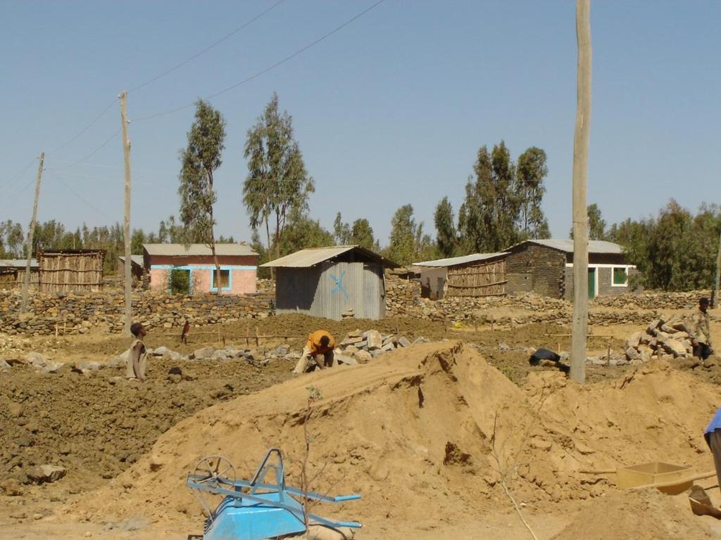
9 Problems observed in relation to site selection Orientation and site adaptation Topography, Drainage and Foundation location of the site Access to Health Centre 9
10 Orientation and site adaptation Climatic conditions The standard design for hot, humid and cold climate should be specified. Wind direction: Arrangement of facilities should consider prevailing wind direction. Buildings should be parallel to the wind direction, Incinerator or combustion box should be placed in such a way that the buildings could not be affected with the smoke. 10
11 Orientation and site adaptation Orientation, sun glare and heat: Buildings should be located with their openings and windows facing the direction with less solar glare and heat North South direction is applicable to most parts of Ethiopia. If there is no convenient site terrain in the surrounding, proper site adaptation has to be done and the standard design has to be modified for that particular site. 11

12 Orientation and site adaptation Orientation and site adaptation 12

13 Failure to adapt HC site 13

14 Failure to Adapt the Site 14

15 Failure to Adapt the Site 15

16 Failure to Adapt the Site 16

17 Failure to Adapt the Site 17

18 Failure to Adapt the Site 18

19 Failure to Adapt the Site 19

20 Failure to maintain gap between blocks 20
21 Topography, Drainage, and Soil Consideration Steep sloped terrain is difficult during construction and expensive. Flat terrain with gentle slope for easy drainage of storm water is ideal for a health center. Complete and accurate data including soil type should be collected for planning and adaptation. 21

22 Drainage Problem, Blocks too close 22

23 Drainage Problem, Block below NGL 23

24 Drainage Problem, Block below NGL 24

25 Wall crack-possible foundation problem 25


26 Drainage Problem, Block below NGL 26

27 Drainage Problem, Block below NGL 27

28 Drainage Problem, Block below NGL 28
29 Improper location of health centers Some of the Factors that should be considered are : Obstruction: high tension power grid, Telephone poles etc Should be at a reasonable distance from noise, Chemical hazards and any sort of pollution. (Grinding mill, High way traffic, chemical factories, slaughter house ) Patients or clients should be able to locate and identify the health center easily. View obstructions to the health center have to be avoided. 29

30 Existing Structures 30
31 Obstruction 31

32 Obstruction 32

33 Blocks scattered-road crossing the HC site Toilet Block OPD, IPD, Delivery 33
34 Access to Health Centre Should have direct access to the town or village and to the majority of the population and Public facilities Should be at a safe distance from flood prone areas, dams, rivers or other water bodies and land slide 34

35 Access to HC site 35

36 Access to HC site 36
")
37 Access to HC site (seasonal) 37

38 Access to HC site (seasonal 38
39 Conclusions Proper selection of the HC site is a major factor that determines economical construction to enable proper function of staff Serious consideration should be given to the selection of the HC site in order to ensure the new HC Will last several decades Be able to deliver quality health services to the local population 39

40 Thank You! 40
Figure 1. Proposed Strategic Habitat Conservation Areas for Florida
 Figure 1. Proposed Strategic Habitat Conservation Areas for Florida Critical Lands and Waters Identification Project (CLIP) Cooperative Effort Century Commission for Sustainable Florida Florida Natural
Brigitte A. Berger, Director of Engineering
 Brigitte A. Berger, Director of Engineering Wilmette s Sewer System Overview of Wilmette s Sewer System Green vs. Gray? Stormwater Action Plan Regulatory Compliance Why Homes Flood What can
URBAN DESIGN GOALS / POLICIES / MEASURES
 URBAN DESIGN GOALS / POLICIES / MEASURES GOALS / POLICIES Authority Consideration of urban design issues in the general plan is provided under the Land Use Element requirements which direct attention to
BROOKHILL NEIGHBORHOOD MODEL ZONING MAP AMENDMENT PREFACE TO APPLICATION
 BROOKHILL NEIGHBORHOOD MODEL ZONING MAP AMENDMENT PREFACE TO APPLICATION June 15, 2015 Revised: August 1, 2016 I. VISION Brookhill is a proposed community based upon the principles of Albemarle County
include playgrounds, sports fields, community gardens and picnic areas.
 DEVELOPMENT PLAN OPEN SPACE SYSTEM OPEN SPACE SYSTEM The neighborhood provides for a range of open space types. The Village Square is an important open space in the neighborhood. It serves as a gathering
ESSENTIAL ENGINEERING FOR PLANNERS
 ESSENTIAL ENGINEERING FOR PLANNERS Presented By Graham Coles, Urban Development Manager (Qld), Arcadis Australia Pacific 7 th March, 2017 Why Me? Biography A ground up background with over 17 years experience
Project: Developer/Designer: Reviewer: I. Narrative: 1. Project Description: Describes the nature and purpose of the land disturbing activity.
 City of Charlottesville, Virginia Erosion and Sediment Control Plan Review Checklist 610 East Market Street, Charlottesville, VA 22902 Telephone 434-970-3182; Fax 434-970-3359 Project: Developer/Designer:
River Corridor Overlay Zone (RCOZ) Article 5
 Article 5") River Corridor Overlay Zone (RCOZ) Article 5 The site is in one of two designated districts. The first is the CBD (central business district) River District, which recognizes the urban character and unique
River Corridor Overlay Zone (RCOZ) Article 5 The site is in one of two designated districts. The first is the CBD (central business district) River District, which recognizes the urban character and unique
WILLAMETTE FALLS LEGACY PROJECT
 OPPORTUNITIES & CONSTRAINTS There are here three falls on a line of rocks extending across the river, which forms the bed of the upper channel. The water is precipitated through deep abrazed gorges, and
Chapter 5: Natural Resources and Environment
 NATURAL RESOURCES AND ENVIRONMENT 5-1 5 Chapter 5: Natural Resources and Environment BACKGROUND AND INTENT Urban expansion represents the greatest risk for the future degradation of existing natural areas,
HUDSON VALLEY REGIONAL COUNCIL 3 Washington Center, Newburgh NY
 PROJECT AREA: HYDE PARK HUDSON VALLEY REGIONAL COUNCIL 3 Washington Center, Newburgh NY 12550 http://www.hudsonvalleyregionalcouncil Insert aerial site photo with streets labeled GREEN INFRASTRUCTURE CONCEPT
Experience the difference.
 Experience the difference. discipline intensity collaboration laboration shared ownership solutions FOCUS ON YOU For more than eight decades, clients have chosen Wilson & Company to help them move from
Longhorsley Neighbourhood Plan
 Site Assessment 1. The availability of the site 1.1 Is the land owner willing for their site to be made available for development? 1.2 If yes, do you have any written evidence to back this up? Planning
Advance Engineering & Surveying PLLC
 Advance Engineering & Surveying, PLLC Consulting in: Civil & Environmental Engineering Land Surveying Land Development 11 Herbert Drive Phone: (518) 698-3772 Latham, N.Y. 12110 Email:ncostape@gmail.com
Municipal Plan*Assessment
 Municipal Plan*Assessment This tool was developed to assist in reviewing municipal master plans and in determining if these plans are consistent with smart growth principles, neighboring municipal plans,
RESPONSES TO PUBLIC CONCERNS AND QUESTIONS
 RESPONSES TO PUBLIC CONCERNS AND QUESTIONS Stations and Summary Questions for Public Meeting #2 June 23, 2015 General Questions / Concerns: 1. Is there any way this development can raise revenue for the
Activity Residential Site Planning
 Activity 2.3.7 Residential Site Planning Introduction When a building is designed apart from a specific site, an opportunity is lost to match the design to the strengths and weaknesses of the site. To
Chapter 3 Site Planning and Low Impact Development
 CHAPTER 3 Site Planning and Low Impact Development Chapter 3 Site Planning and Low Impact Development 3.0 Introduction The City of Charleston requires that major residential, large commercial (>1 acre),
Highway Alignment and Route Location Survey
 CHAPTER 2 Highway Route Surveys and Location Introduction To determine the geometric features of road design, the following surveys must be conducted after the necessity of the road is decided. Type of
A multidisciplinary approach to sewage and storm water drainage Case studies of the towns of Pula and Rovinj. Authors: Tatjana Uzelac, Katja Sošić
 A multidisciplinary approach to sewage and storm water drainage Case studies of the towns of Pula and Rovinj Authors: Tatjana Uzelac, Katja Sošić 1 Multidisciplinary approach to sewage and storm water
New-Cast Mixed-use Development Proposal King Street West, Newcastle, Ontario
 URBAN DESIGN BRIEF New-Cast Mixed-use Development Proposal King Street West, Newcastle, Ontario TABLE OF CONTENTS: 1.0 Executive Summary 2.0 Creating Vibrant and Sustainable Urban Places: Excerpts from
Green Roof Field Trip
 Adapted from the rain garden curriculum created by the University of Wisconsin, Madison, Arboretum s Earth Partnership for Schools Grade level: Elementary (K 6); Group size: 12 35; Time needed: 1 to 3
HICKORY NUT FOREST DESIGN GUIDELINES
 HICKORY NUT FOREST DESIGN GUIDELINES Introduction Hickory Nut Forest is a "net-zero energy", conservation development that is designed to protect and celebrate the property s unique ecology. A conservation
I. INTRODUCTION. Project Background and Study Area
 I. INTRODUCTION Project Background and Study Area Freedom Parkway is a key east-west corridor connecting I-25 on the west to the Town of Kersey on the east, running approximately one to two miles south
Presented by: Theuns van der Linde
 Introducing the concept of Disaster Risk Reduction Through Environmental Design (DRRTED), and proposing a methodology for the creation of safer environments. Presentation prepared for: Conference in Disaster
Map Figure 1 prepared by Ardaman & Associates and included in the Conceptual Design Report dated June 20, 2007
 VIII. Site Analysis A. SITE TOPOGRAPHY Site Dynamics Map 3.1 from Inventory & Analysis Section of Campus Master Plan Existing Conditions Topography Map C1.0 from Walter Fedy USF Lakeland Conceptual Design
Town of Essex Small Site Erosion Control Guide
 Town of Essex Small Site Erosion Control Guide Why do we need to protect against erosion? Water Quality: Erosion and the transport of sediment and pollutants impacts the water quality of nearby streams
QUEENSTOWN LAKES DISTRICT COUNCIL SUBDIVISION DESIGN GUIDELINES
 Attachment C: Draft QLDC Subdivision Design Guidelines QUEENSTOWN LAKES DISTRICT COUNCIL DESIGN GUIDELINES A DESIGN GUIDE FOR AND DEVELOPMENT IN THE URBAN ZONES QUEENSTOWN OFFICE 10 Gorge Road Queenstown
Application of GIS and Remote Sensing for Identifying Flood Risk in Ho Chi Minh City, Vietnam
 Application of GIS and Remote Sensing for Identifying Flood Risk in Ho Chi Minh City, Vietnam Vo Le Phu and Luu Dinh Hiep Faculty of Environment Ho Chi Minh City University of Technology volephu@hcmut.edu.vn
Summer Public Education and Outreach Campaign Toolkit
 Summer Public Education and Outreach Campaign Toolkit ABOUT THIS TOOLKIT The communications tools and messages included in this toolkit were developed by Bluestem Communications for the Lower DuPage River
SUSTAINABLE LANDSCAPE DESIGN
 Biolandscape Ltd. 5A Willerton Ave I New Lynn I Auckland I New Zealand PO Box 19681 Avondale Auckland 1746 New Zealand 09 620-9027 I 0274 378867 I gilbert@biolandscape.co.nz INFO FACT SHEET No1 SUSTAINABLE
City of Meriden Harbor Brook Flood Control Project Overview
 City of Meriden Harbor Brook Flood Control Project Overview Updated August 2013 OVERVIEW The center of Meriden, including the HUB site is the low point of the town which is ringed by basalt ridges. Running
Neighbourhood Planning Site Assessment Pro-forma and Guide Version 2
 Neighbourhood Planning Site Assessment Pro-forma and Guide Version 2 September 2014 Site HNP 006 Land East of Stanbridge Road and North of Lower Road 1. Background information Site location and use Site
Checklists. Project Name: Location: File Number: Date of Submittal: Reviewer: Date: Applicant: Contact Name: Phone Number:
 Applicant: Contact Name: Phone Number: Email: Project Name: Location: File Number: Date of Submittal: Reviewer: Date: Concept Plan Requirements: I. General Project Information 1. Address or parcel number
Air Ventilation Assessment (AVA) System for High Density Planning and Design
 System for High Density Planning and Design") Air Ventilation Assessment (AVA) System for High Density Planning and Design September 2006 PLEA2006 An ideal scene Hong Kong? Who needs to worry about design for city ventilation if we all have a view
Air Ventilation Assessment (AVA) System for High Density Planning and Design September 2006 PLEA2006 An ideal scene Hong Kong? Who needs to worry about design for city ventilation if we all have a view
Errol Heights Park and Community Garden Frequently Asked Questions March 22, 2018
 Errol Heights Park and Community Garden Frequently Asked Questions March 22, 2018 Question 1: What improvements are planned for Errol Heights Park? How will the community be engaged in the process to shape
KHARTOUM GARDEN CITY. Dietmar Kamphans
 KHARTOUM GARDEN CITY Dietmar Kamphans As most cities in the world have been set up at river banks and sea shores, even Khartoum is located at the confluence of the Blue and White Nile. Beside the regular
A/E REVIEW CHECKLIST SITE & LANDSCAPE
 A/E REVIEW CHECKLIST SITE & LANDSCAPE Reviewers should - Use Checklists when reviewing any type of VA construction project for the following disciplines: Architectural, Boiler Safety Devices Operation
ions nts July 1, 2019 The utility answers to some increase: Q: A: rainwater Q: A: areas any the total by
 Frequently Asked Quest ions Stormwater Rate Adjustmen nts The Fort Wayne Board of Stormwater Management and Fort Wayne City Council have approved an increasee stormwaterr utility fees to address neighborhood
In 1983, the town evacuated and purchased by government for $36 million
 1 2 3 4 5 6 7 8 9 Introduction to Environmental Geology, 5e Chapter 17 Soil and Environment Weathering: summary in haiku form Rocks brought to surface decompose to sediment and that's weathering. Case
CITY PLANNING COMMISSION AGENDA. ITEM NO: 6.a 6.b STAFF: LONNA THELEN
 Page 156 CITY PLANNING COMMISSION AGENDA ITEM NO: 6.a 6.b STAFF: LONNA THELEN FILE NO(S): A. - CPC ZC 08-00069 QUASI-JUDICIAL B. - CPC CU 08-00070 QUASI-JUDICIAL PROJECT: APPLICANT: OWNER: PHIL LONG VALUCAR
STORM WATER MANAGEMENT SYSTEMS
 STORM WATER MANAGEMENT SYSTEMS MichiganReportCard.com 38 GRADE D+ STORM WATER MANAGEMENT SYSTEMS OVERVIEW Michigan s storm water management system provides flood protection, makes development possible,
PROTOTYPE DESIGN/INTRODUCTION
 PART III: PROTOTYPE DESIGN These concepts and guidelines described earlier were used to develop a prototype design for an emerging suburban area located west of the City of Milwaukee. This was done to
Mollers Lane, Leopold, Victoria Significant Landscape Overlay Re-assessment
 XURBAN Mollers Lane, Leopold, Victoria Significant Landscape Overlay Re-assessment For: TGM Group November 2016 Final Mollers Lane, Leopold, Victoria Significant Landscape Overlay Re-assessment Client
TRANSPORTATION: Roads and Highways Services
 TRANSPORTATION: Roads and Highways Services Profile Our background GIBB is a leading multi-disciplinary engineering consulting firm based in South Africa with 67% Black ownership. The firm has a strong
SPANISH TOWN, ST. CATHERINE JAMAICA
 SPANISH TOWN, ST. CATHERINE JAMAICA This presentation is aimed at emphasizing the importance of an effective community flood alert component of Community Flood Warning Systems (CFWS) in vulnerable communities
Toronto Complete Streets Guidelines
 Toronto Complete Streets Guidelines 108 110 7.1 Green Infrastructure Design Principles 112 7.2 Context-Sensitive Green Streets 114 7.3 Key Green Street Elements Green infrastructure refers to natural and
GUIDELINES FOR PERMEABLE SIDEWALK-LANDSCAPING PERMIT
 GUIDELINES FOR PERMEABLE SIDEWALK-LANDSCAPING PERMIT Green spaces are vital to San Francisco s quality of life as they provide a range of environmental benefits and bring beauty to our neighborhoods and
DATE ISSUED: March 12, 2014 REPORT NO: 101. Old Globe Way Improvements and San Diego Zoo Employee Parking Structure
 DATE ISSUED: REPORT NO: 101 ATTENTION: SUBJECT: Park and Recreation Board Agenda of March 20, 2014 Old Globe Way Improvements and San Diego Zoo Employee Parking Structure SUMMARY Issue Should the Park
Draft Part 11 Heritage Area Plans West Wallsend / Holmesville
 TABLE OF CONTENTS: PART 1 WEST WALLSEND / HOLMESVILLE HERITAGE AREA PLAN... 3 1.1 INTRODUCTION... 3 1.2 BACKGROUND... 3 1.3 LAND TO WHICH THIS PLAN APPLIES... 3 PART 2 WEST WALLSEND / HOLMESVILLE HERITAGE
CRESCENT RESOURCES INC.
 CRESCENT RESOURCES INC. Due Diligence Checklist Project Name: Client: Project No. Date: 1 Survey Review survey for compliance with Crescent Resources, Inc. s Instructions to Surveyors (see below): All
SALEM FOREST RIVER PARK PRELIMINARY POOL AREA ASSESSMENT & MASTER PLAN STUDY. For the City of Salem
 SALEM PRELIMINARY POOL AREA ASSESSMENT & MASTER PLAN STUDY For the City of Salem 6-13-17 This process undertaken by Weston & Sampson is to outline preliminary ideas only of what possibilities exist for
Site Analysis. Development / Framework. Development Framework. Overall Site Constraints
 Site Analysis Overall Site Constraints As well as being constrained by the M1 LDP boundary the site has several major factors influencing the rational development of the site. We have control of all of
Population, Housing, and Employment Analysis
 Population, Housing, and Employment Analysis Reviewed housing development patterns, trends, needs, affordability, and estimated employment and population capacity at full build out. Total 28,200 people
DEPARTMENT OF PLANNING JEFFERSON PARISH, LOUISIANA
 DEPARTMENT OF PLANNING JEFFERSON PARISH, LOUISIANA DESIGN REVIEW REPORT DOCKET NO: : : : Paul D. Johnston AT LARGE: A: Christopher L. Roberts B: Cynthia Lee-Sheng ADVERTISING DATES: PAB PUBLIC HEARING:
Urban Stormwater Management. Rebecca Leonardson Rui Teles Brooke Ray Smith
 Urban Stormwater Management Rebecca Leonardson Rui Teles Brooke Ray Smith Introduction Stormwater in Portugal Why urban stormwater is currently a problem What is green stormwater management? Why it is
Article 6 Tree Protection
 Article 6 Tree Protection 8.1 Purpose 8.2 Applicability 8.2.1 General Provisions 8.2.2 Exemptions 8.3 Permitting Procedure 8.4 Planting Procedure 8.5 Performance Guarantee Required for Belated Planting
CMHC HOME MAINTENANCE CHECKLIST
 Make sure air vents indoors and outdoors (intake, exhaust and forced air) are not blocked by snow or debris. Check and clean range hood filters on a monthly basis. Test ground fault circuit interrupter(s)
Design GuidelineThemes: Integrated Stormwater Detention and Landscape
 Design GuidelineThemes: Integrated Stormwater Detention and Landscape Design Integrated Stormwater Detention Detention/Flood Control Provide needed flood control while improving playability 100 year event
Goals & Objectives (best derived from an input
 Goals & Objectives (best derived from an input process) Goal - sets an intent of the project States the expected result or outcome of the project The trail will provide recreation and transportation opportunities
Using Height Access Poles for Safe Testing Of Fire Detection Systems
 Using Height Access Poles for Safe Testing Of Fire Detection Systems Introduction Who are Detectortesters Manufacturers of industry standard test equipment for testing fire detectors Re-branded from No
City of Hermosa Beach Administrative Policy #
 City of Hermosa Beach Administrative Policy # SUBJECT: Living Streets Policy Date: Approved by: City Council Authority: Public Works Department & Community Development Department Mayor, PURPOSE The City
Holmberg & Howe, Land Surveyors and Civil Engineers Zoning District: R-35
 Development Impact Statement Name of Project: Red Tail Drive Acreage: 13.5 Acres± Type of Project: Residential Subdivision Owner: 96 East Street Development, LLC Location: rear of 112 East Street Parcel
This Review Is Divided Into Two Phases:
 Semiahmoo Town Centre Review The purpose of this review: To review the Semiahmoo Town Centre Concept Plan, originally approved in 1993, to ensure that this centre will continue to serve the needs of South
Engineering canopy solutions that are built to last
 Engineering canopy solutions that are built to last An inside guide to site-specific calculations www.canopiesuk.co.uk CONTENTS 1 2 3 4 5 Calculating quality - the Canopies UK way. What are site-specific
Seattle Transit Master Plan
 Seattle Transit Master Plan Seattle City Council Transportation Committee Briefing May 10, 2011 Seattle Department of Transportation Presentation Outline Review of project schedule and goals Review of
Vu Kim Chi Nguyen Thi Thuy Hang
 Vu Kim Chi Nguyen Thi Thuy Hang Tokyo, Dec 7, 2015 Introduction Data and methods Results and discussions Conclusion The city of Quy Nhon Urban planning in Quy Nhon Climate change and sea level rise Natural
Operation and Maintenance Manual
 Operation and Maintenance Manual In compliance with the California Green Building Standards Code, this Operation and Maintenance Manual shall be available at final inspection and remain with the building
Advanced Site Inventory Activity
 9-12 ACTIVITY Advanced Site Inventory Activity 9-12 ACTIVITY Summary: Students investigate various elements of their Schoolyard Habitats site, including climate, land use, and human impact. Grade Level:
TOWNSHIP OF LOGAN SOIL & FILL IMPORTATION AND PLACEMENT APPLICATION SUBMITTAL CHECKLIST
 TOWNSHIP OF LOGAN SOIL & FILL IMPORTATION AND PLACEMENT APPLICATION SUBMITTAL CHECKLIST Applications: 5 copies of application - Applicant will reproduce the copies at his/her costs. The Township Clerk
Topography & Site Planning
 Topography & Site Planning The gradient of paths, the use of areas, the placement of buildings, the flow of utilities, visual form = In itself topography sometimes determines design. Influences of topography
Pole Mounting System Installation & Certification Manual
 Pole Mounting System Installation & Certification Manual IronRidge Pole Mount Installation Guide... 2 IronRidge Certification Letter... 14 IronRidge Wet Stamped Drawing... 15 IronRidge Foundation Addendum...
CAPE ELIZABETH, MAINE TOWN CENTER STORMWATER MANAGEMENT PLAN UPDATE
 CAPE ELIZABETH, MAINE TOWN CENTER STORMWATER MANAGEMENT PLAN UPDATE September 2015 This report was prepared by The Town of Cape Elizabeth under award CZM NA14NOS4190066 to the Maine Coastal Program from
Introducing the Good Practice Notes on Life and Fire Safety for Hotels and Hospitals
 Introducing the Good Practice Notes on Life and Fire Safety for Hotels and Hospitals 19 Dec 2017 Presentation by Elena Chuzhakova, Luis Cestari (IFC) & Ralf Bruyninckx (FPC Risk) Our presenters Elena Chuzhakova
Zoning Ordinance Chapter 10
 CHAPTER 10 - WASHES SECTION 10.0 GENERAL: A. The purpose of this Ordinance is to establish standards for development in or near Major and Minor Washes as defined in Appendix A Glossary of Terms and Definitions
SITE PLAN REVIEW PROCESS
 BOWNE TOWNSHIP PO Box 35, 8240 Alden Nash Road, Alto, Michigan 49302 Ph. 616-868-6846 Fax 616-868-0110 http://www.bownetwp.org SITE PLAN REVIEW PROCESS 1. Application Form and Fee Schedule Site Plan Review
TIDAPA Structure Plan
 TIDAPA Structure Plan Prepared by Tract Consultants 28 MARCH 2017 0217-0074 Table of Contents 01 STRATEGIC CONTEXT Executive Summary Regional Context Page 3 Page 4 02 LOCAL CONTEXT Aerial Photograph Local
Town of West Point Plan of Development
 Town of West Point Plan of Development Plan Submission In accordance with Section 70-51(b) of the Town Code, the Zoning Administrator shall establish a written policy for the form, format, content and
Strategies and Projects for Climate Adaptation in the Region of Stuttgart A Multi-Level Approach
 Strategies and Projects for Climate Adaptation in the Region of Stuttgart A Multi-Level Approach Dr. Christoph Hemberger Verband Region Stuttgart Dr. Katja Walther City of Esslingen Dipl.-Ing. Albrecht
20 July 2015 A REVIEW OF STUDIES ON THE RELATIONSHIP BETWEEN URBAN MORPHOLOGY AND URBAN CLIMATE TOWARDS BETTER URBAN PLANNING AND DESIGN
 A REVIEW OF STUDIES ON THE RELATIONSHIP BETWEEN URBAN MORPHOLOGY AND URBAN CLIMATE TOWARDS BETTER URBAN PLANNING AND DESIGN IN (SUB)TROPICAL REGIONS Justin Ho Chao Ren Edward Ng The Chinese University
ARISE: The Rock Renaissance Area Redevelopment & Implementation Strategy
 2014 Professional Awards 1 ARISE: The Rock Renaissance Area Redevelopment & Implementation Strategy Janesville, WI Completed December 2014 Analysis & Planning Purpose of Project 2 The purpose of the Rock
Site Design. Planning Check List. Looking at the whole site First things first Preparing the plan
 Site Design Site Design Looking at the whole site First things first Preparing the plan Sample Site Plans Adding information to the plan Adding comments from the surveys Adding ideas to the plan A plan
Quality Report. Overall summary Kremlin Drive Stoneycroft Liverpool L13 7BY Tel: Website:
 Park View Project (Havens) Quality Report 30--34 Kremlin Drive Stoneycroft Liverpool L13 7BY Tel: 0151 228 9167 Website: www.riverside.org.uk Date of inspection visit: 30 September 2016 Date of publication:
3. SITE ANALYSIS 3.1. INTRODUCTION
 3. SITE ANALYSIS 3.1. INTRODUCTION According to the syllabus of design of IV/II, the department has provided us the neighborhood planning. The main purpose of this project is to expose the students to
VILLAGE & TOWN OF BERGEN: COMPREHENSIVE PLAN
 VILLAGE & TOWN OF BERGEN: COMPREHENSIVE PLAN CPC Public Hearing April 21, 2016 History 1996 Comprehensive Plan Comprehensive Plan Update Committee Consultant (LaBella Associates): December 2014 Residents
BULLETIN #1 Summerfield/Riverwalk Fencing Criteria
 BULLETIN #1 Summerfield/Riverwalk Fencing Criteria PRIVACY FENCES (typically required on interior lots): Privacy fences shall be a maximum of six (6 ) feet high. The standard fence specified is Country
PERMACULTURE & REGENERATIVE WHOLE SYSTEMS: ECOLOGICAL DESIGN SERVICES & CONSULTATIONS. Urban Master Plans
 PERMACULTURE & REGENERATIVE WHOLE SYSTEMS: ECOLOGICAL DESIGN SERVICES & CONSULTATIONS We create resilient drought tolerant edible landscapes Urban Master Plans The Foundation Master Plan This design provides
Urban Watershed Mentors
 Urban Watershed Mentors Bureau of Environmental Services Josh Robben Urban Stormwater background Stormwater retrofits Site assessment Design considerations Maintenance considerations Resources/programs
Site ref: AS06 Site Name or Address: Murreys Court, Agates Lane
 Site ref: AS06 Site Name or Address: Murreys Court, Agates Lane Proposed Land Use: Total Site Area (Ha): Housing 1.85 Ha Description: It is understood that the owner has no plans to dispose of the site
Highway Oriented Commercial Development Criteria
 7.6 HOC-1 Highway Oriented Commercial District A. Statement of Purpose The Highway Oriented Commercial District (HOC-1) is intended to provide for the development of high density retail and service businesses
MODULE 3 RESTRUCTURING THE ENVIRONMENT
 MODULE 3 RESTRUCTURING THE TOWNSHIP PHYSICAL ENVIRONMENT FOCUS OF THE MODULE The physical and spatial (locational) characteristics that prevent townships from developing Levels of intervention: Things
Green Street Challenges and Design Considerations. Watershed Revegetation Program Bureau of Environmental Services
 Green Street Challenges and Design Considerations Watershed Revegetation Program Bureau of Environmental Services Jeremy Person, PLA, LEED AP March 2017 Presentation Outline Background Challenges and Considerations
RV Park/Campground Operator s Manual
 RV Park/Campground Operator s Manual Chapter 9 Principles For Designing A New RV Park/Campground The Region The Site (Land) / maps, conditions, climate, topography, drainage, site evaluation Facilities
FLAGSTAFF FAMILY FOOD BANK Erik Henricksen, Elena Smith, Garrett Ribas, and Meshal Alotaibi Client: Joshua Spears TA: Dr.
 FOOD STORAGE FACILITY FLOODING FLAGSTAFF FAMILY FOOD BANK Erik Henricksen, Elena Smith, Garrett Ribas, and Meshal Alotaibi Client: Joshua Spears TA: Dr. Wilbert Odem 1 BACKGROUND Figure 1: Food Bank Front
Plan Review Checklist
 Plan Review Checklist FOR EROSION AND SEDIMENT CONTROL PLANS _ Minimum Standards - All applicable Minimum Standards must be addressed. All minimum Standards must be adhered to during the entire project
Multi-Criteria Fire Alarm (Mcfa)
") Multi-Criteria Fire Alarm (Mcfa) March 5, 2012 Jacob Y. Wong Airware Inc. The State of Today s Low Cost Fire Detectors A $10 ionization smoke detector is notoriously *False-alarm prone *Radioactive (Americium
Multi-Criteria Fire Alarm (Mcfa) March 5, 2012 Jacob Y. Wong Airware Inc. The State of Today s Low Cost Fire Detectors A $10 ionization smoke detector is notoriously *False-alarm prone *Radioactive (Americium
Two Sides of the Green Infrastructure Coin. Jaren Hiller, PE, LEED AP Nathan Guequierre
 Two Sides of the Green Infrastructure Coin Jaren Hiller, PE, LEED AP Nathan Guequierre May 5, 2016 Background Citywide Stormwater Planning WinSLAMM Analysis No Control Existing Conditions Proposed Conditions
Installation Manual Universal Top-of-Pole Mount UNI-TP/08LL
 Installation Manual Universal Top-of-Pole Mount UNI-TP/08LL Solar Mounting Solutions UNI-TP/08LL April 2010 www.ironridge.com 2010 IronRidge, Inc. All Rights Reserved Version 2.0 2 Universal Top-of-Pole
RADON LAZERWEB SERVICES
 RADON LAZERWEB SERVICES WWW.LAZERWEBSITES.COM Contents Overview...2 Radon is estimated to cause thousands of lung cancer deaths in the U.S. each year...2 Radon is a cancer causing, radioactive gas...2
495/MetroWest Development Compact Plan Citizen Planner Training Collaborative Conference. March 17, 2012
 495/MetroWest Development Compact Plan Citizen Planner Training Collaborative Conference March 17, 2012 Project Process Local and Regional Priority Areas Growth Scenarios Transportation Investment Categories