Vintage at Kings Canyon Conceptual PUD. Prepared by:
|
|
|
- Antonia O’Neal’
- 6 years ago
- Views:
Transcription


1 Vintage at Kings Canyon Conceptual PUD Prepared by: June 7, 2016
2 Vintage at Kings Canyon Conceptual PUD Prepared for: Vintage at Kings Canyon, LP Prepared by: Rubicon Design Group, LLC 100 California Avenue, Suite 202 Reno, Nevada (775) June 7, 2016
3 Table of Contents Introduction... 1 Project Location... 1 Existing Conditions... 2 Project Description... 4 Master Plan and Zoning... 8 Planned Unit Development Project Theme Stormwater Management and Drainage Neighborhood Input Master Plan Policy Checklist Conceptual PUD Map Findings Approval or Denial of Application List of Figures: Figure 1 Vicinity Map... 1 Figure 2 Existing Zoning... 2 Figure 3 Existing Conditions... 3 Figure 4 Preliminary Site Plan... 5 Figure 5 Existing/Proposed Master Plan Designations... 9 Figure 6 Existing/Proposed Zoning Figure 7 Conceptual Architecture Figure 8 Conceptual Architecture Figure 9 Conceptual Architecture Figure 10 Conceptual Architecture Appendix: Carson City Application Form and Checklist i
4 Attachments: Preliminary Engineering Plans Preliminary Landscape Plan Preliminary Architecture Plans ii

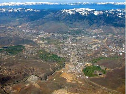
5 Introduction This application includes the following request: A Conceptual PUD Map Application, to allow for the coordinated development of four parcels in the SF6, SF12, and SF1A zones. A Master Plan Amendment and Zone Change is required at the eastcentral portion of the site to allow for limited mixed uses. Project Location Vintage at Kings Canyon is located west of Mountain Street and north of King Street in an existing developed area. Figure 1 (below) depicts the project location. Parcel numbers for the site are , 07, 08, and The total site area is ± acres. Figure 1 Vicinity Map 1
6 Existing Conditions The site is primarily vacant and includes a mix of residential zoning categories. The eastern 7.8-acre parcel is zoned Single Family 6000 square foot lots (SF6). The remaining three parcels are zoned Single Family 12,000 square foot lots (SF12) and Single Family 1-Acre (SF1A). Figure 3 (below) provides a map of the existing zoning. Figure 2 Existing Zoning 2

7 Surrounding uses include single family homes to the north, south, and west, with non-residential uses near the eastern property boundary, including a medical center, limited supporting retail, and medical office space. The site is well served by the area road network. It is 1,675± feet (straight line distance) west of North Carson Street and can be accessed on its east side via Bath Street, Long Street, Fleischman Way, and Washington Street, which all connect to Mountain Street. The western edge of the property can be accessed via Winnie Lane and Ormsby Boulevard. This site can be developed without altering traffic patterns in the surrounding area and does not require driving connections directly into existing neighborhoods to the north and south for primary access. Instead, primary access will be from Mountain Street and Ormsby Boulevard. Traffic will therefore be directed to the existing collector streets (e.g. Mountain, Ormsby, Winnie, Long, Washington) and not into the neighborhoods. Existing buildings at the southwest portion of the ranch include one house, barn, and ancillary farm buildings near the southern property boundary. A goal of the proposed PUD is to integrate the farm and existing structures into the overall project theme. Thus, Vintage at Kings Canyon looks to carry on the traditional architectural style of the ranch. Figure 3 (below) is a view of the property looking west from Mountain Street, showing adjacent single family housing along the north property line. Figure 3 Existing Conditions 3
8 Project Description Vintage at Kings Canyon is a Planned Unit Development that provides for a mix of housing types, including large, medium, and small lot single family homes. Also included are assisted living and independent living units that are clustered in a village-type setting. The community will include a ranch house office as well as a clubhouse, pool, walking trails, rose garden, etc. all for the enjoyment of residents. The goal is to create a complete neighborhood that includes facilities catered to aging residents. Such residents can remain within the neighborhood and continue to interact with family members and friends. The entire community will be age-restricted to 55 an older residents. The assisted living/independent living facilities include an attached dining and socializing area as well as a landscaped courtyard. Total building space for the assisted living facility is approximately 45,000± square feet, contained in two single-story buildings. The independent living facility is approximately 21,000± square feet and is also single story. Based on neighborhood input, these buildings are clustered within a village setting interior to the project site. A 4,000± square foot office will be constructed adjacent to the assisted/independent living facility and will serve as a sales office and information office for the project. Commercial operations will not be included within the office area. Additionally, a green house and ancillary maintenance buildings are included within the project plan. The project plan reserves a 49.14± parcel (portion of APN # ) located west of Ormsby Boulevard, north of King Street. No development is proposed for this area at this time. The parcel will be retained by the existing owners for future use and/or development. The project also includes a substantial open space/public amenity elements throughout the plan and includes walking trails, vineyard areas, community gardens, and other resident amenities. Figure 4 (following page) provides an overall site plan and depicts the various open space areas and amenities. A total of 28.4± acres of open space are provided within the project. This includes 5.9± acres of private open space in accordance with the requirements set forth in the Carson City Municipal Code (Section ). These open space calculations do not include areas less than 25 feet in width or any areas within lots or right-of-way areas. 4

9 Note: A full size site plan is included in the attached map pocket. Figure 4 Preliminary Site Plan 5
10 A total of 212 single family units are proposed within Vintage at Kings Canyon. This total density is permitted under the existing SF-6, SF-12 and SF-1A zoning that exists across the site. The proposed PUD will allow for the clustering of the units which allows for the preservation of open space and amenities. Also, clustering will provide for lot sizes that are more manageable for elderly residents. Yard maintenance will be provided by the community s homeowners association (HOA). It is important to note that the existing density associated with the 5.56± acres proposed for rezoning has been excluded. The following table provides a summary of how the density for the project is calculated. East of North Ormsby Parcel Number Post BLA Parcel Number Area Zoning Max. DU/AC Unit Yield ± ac SF ± ac 1 SF ± ac SF East of North Ormsby Subtotal 42.56± ac 181 West of North Ormsby Parcel Number Post BLA Parcel Number Area Zoning Max. DU/AC Unit Yield N/A 60.9± ac SF1A ± ac SF West of North Ormsby Subtotal 80.14± ac 102 Project Total 122.7± ac Excludes 5.56± acres to be rezoned. As the table above demonstrates, density to support 283 units exists under the existing conditions. In addition to the 212 single family units, 64 assisted living units are proposed along with 29 independent living units for a total of 305 units. The assisted/independent living units are considered a commercial use under the Carson City Municipal Code and are therefore not counted in terms of the allowed density calculations. Therefore, there is a surplus of 71 residential units remaining that will be retained by the current property owner. As depicted previously in Figure 4, smaller single family lots are generally clustered in the central portion of the site. Lots on the north side are larger in order to complement existing adjoining homes. This is also true for lots on the west side of Ormsby Boulevard. A large open space buffer is located along the south side of the project in order to ensure compatibility between new homes in Vintage and existing homes to the south. 6
11 The following table provides an overall summary of the unit types proposed. Vintage at Kings Canyon Development Summary Unit Type 1 Description Total Units A Single Family 10,000± sq.ft. lot size 11 units B Single Family 8,500± sq.ft. lot size 15 units C Single Family 3,365± sq. ft. lot size (zero lot line) 58 units D Single Family 1,690± sq.ft. lot size (zero lot line) 69 units E Single Family Estates 35,000± sq.ft. lot size 4 units F Single Family 12,000± sq.ft. lot size 55 units Assisted Living Assisted Living Single Story Building 64 units Independent Living Independent Living Single Story Building 29 units TOTAL 305 units 1 Refer to Figure 4 that indicates unit types. The assisted living and extended care operations will have some impact on the area but are far more self contained than a single family residential development. This is primarily true for impacts such as traffic generation, landscape water use, etc. These impacts are greatly reduced or non-existent for this element of the project. Vintage at Kings Canyon is envisioned to be developed in 5 phases. Phasing will occur from east to west. The assisted/independent living component of the project along with single family homes will be included in the first phase. The remaining phases will be entirely single family. Figure 4 (previous) includes the proposed phases. It is proposed to construct the passive park and trail along the southern boundary (east of Ormsby) with the first phase. The trail along the existing ditch will be completed in phase 4 while interior trails will be constructed phase by phase. As an age-restricted community, overall impacts are much less than a comparable standard subdivision. For example, Vintage at Kings Canyon will generate no impacts to schools. Additionally, smaller lot sizes result in the need for less water consumption. Age-restricted communities also tend to generate less noise than standard subdivisions as there are typically no children at play, less nighttime activity, etc. In terms of traffic impacts, age-restricted communities generate 40-60% less traffic on average than typical subdivisions. This is largely in part to the fact that many of the residents will utilize onsite shuttle services or do not drive. It is also important to note that standard subdivisions often include more than 2 drivers per household (i.e. teen drivers and multiple residents per unit). Vintage at Kings Canyon will include covenants, conditions, and restrictions (CC&R s) which limit permanent occupancy to 2 people per dwelling. For those that do drive, residents typically generate far less peak hour trips as a significant portion of the residents are retired and will not be travelling during typical commute hours. 7
12 As noted previously, primary access to the site is from Mountain and Ormsby Streets. This ensures that traffic patterns within the existing neighborhoods will be far less impacted. Secondary access is provided via connections with Bolero Drive and Lexington Avenue. However, it is anticipated that these roadways will get little use as they do not provide direct connections to the arterial street system and are less convenient in terms of reaching everyday services and common destinations. A full traffic impact analysis will be provided with the forthcoming tentative map and PUD applications. Master Plan and Zoning As an infill project, the site is already provided with Master Plan and zoning designations. These designations allow for a mix of housing products on the site. In general, Vintage at Kings Canyon intends to construct a mix of housing products. However, the project also includes assisted/independent living care facilities. The Carson City Municipal Code defines this as a commercial use type although it is residential in nature. For this reason, the project requires a Master Plan Amendment and zone change for an approximately 5.56± acre portion of the property central to the site. The remainder of the site will retain its existing Master Plan and zoning designations. As noted above, the project will adhere to the existing overall development density for residential units. The Master Plan Amendment and zone change will not result in an increase in the number of allowable units. Figures 4 and 5 (following pages) depict the current and proposed zoning and current and proposed Master Plan designations. As Figures 5 and 6 depict the Master Plan Amendment and zone change requests affect 5.56± acres. It is proposed to amend the existing Medium Density Residential Master Plan designation to Mixed-Use Residential and the existing SF-12 zoning to Neighborhood Business (NB) for the subject area. This is simply to allow for the commercial use associated with the assisted and independent living components of the project. 8


13 EXISTING MASTER PLAN PROPOSED MASTER PLAN Figure 5 Existing/Proposed Master Plan Designations 9

14 EXISTING ZONING PROPOSED ZONING Figure 6 Existing/Proposed Zoning 10
15 Planned Unit Development As previously noted, it is planned to develop Vintage at Kings Canyon as a Planned Unit Development (PUD). Therefore, concurrent with the Master Plan Amendment, Zone Change, and Tentative Map applications, a comprehensive design standards handbook will be submitted. This handbook will provide highly specific standards related to allowed uses, maximum density, maximum building heights, lighting, landscaping, architecture, open space, project amenities, operating requirements (i.e. delivery times for assisted living), buffering, maintenance of common areas/amenities, etc. By incorporating the PUD approach, the City and surrounding neighbors are given assurances as to what will be developed at the site. Unlike a standard zoning approach, the handbook will limit uses. Thus, if the project ever were to be sold or undeveloped, commercial uses (other than assisted/independent living) would be prohibited within the NB area. Additionally, the PUD is recorded against the property and runs with the land. Thus, any change in ownership would result in zero change as to what can be developed. Any change in use would require a full public approval process. The PUD development standards handbook will be submitted concurrently with the forthcoming entitlement requests. Project Theme The project is inspired by an upscale farmhouse wine-country theme. As such, the project incorporates vineyard areas, community gardens, barns, etc. Also, architecture and entry monumentation will be reflective of this theme as well. The forthcoming PUD handbook will provide specific details and standards to ensure that the project theme is adopted and maintained, providing a consistent look to the final project. Figures 7 through 10 (following pages) provide architectural concepts that will be incorporated into the PUD. 11

16 Figure 7 Conceptual Architecture 12

17 Figure 8 Conceptual Architecture 13

18 Figure 9 Conceptual Architecture 14
19 Figure 10 Conceptual Architecture 15
20 Stormwater Management and Drainage The site includes a mix of FEMA Flood Zone classifications, making the site suitable for development provided that proper stormwater management is included in the design. The eastern three parcels of the site are primarily classified as Zone X Shaded, which is out of the flood zone. A portion of this area is classified as zone AO. The western-most parcel is primarily classified as zone AE, with a small amount of both AO and Zone X - Shaded. The AO and AE zones will require proper design and grading modifications to manage any stormwater impacts. Fortunately, the developed areas surrounding the site exhibit stormwater management design that effectively handles runoff. This is evidenced by the GIS and FEMA data showing that surrounding development is primarily classified as Zone X Shaded, suggesting that effective stormwater management is feasible in the area. There is an existing irrigation ditch that runs from the west to the east across that will remain in place. This ditch also serves as a separation between the proposed lots and the open space. This area is being considered for additional landscaping. Currently flood waters run across Ormsby and collect on the southern edge of the project boundary and then dissipate onto the neighboring streets according to the existing FEMA mapping. Although the site will be improved in this area, overall flow patterns will be maintained in conformance with City code. In general, drainage from the site moves from west to east. However, different sections of the site can be designed to perform somewhat independently. For example, the western-most parcel has ample room to detain runoff, which can then move in a controlled fashion to the east, as needed. There is a large-capacity drainage pipe already installed on Mountain Street and this will serve to ultimately remove runoff from the site. Neighborhood Input The Vintage at Kings Canyon project has had extensive scrutiny by community residents. After listening to resident concerns, significant changes have been incorporated into the project plan. These changes will be further detailed in the forthcoming entitlement requests. However, the bullet points below highlight some of the key amendments to the plan submitted previously for conceptual review: Commercial is limited to assisted/independent living only. Any ancillary commercial use (i.e. salon, barber, etc. will be located internal to the buildings for exclusive resident use only. Open space areas have been increased. Significant buffering has been included on the south side of the project. The office component of the project (excluding a sales/information office) has been removed. Perimeter lot sizes have increased. Assisted/independent living units have been relocated central to the site so that they do not adjoin any existing residences, 16
21 It is also noteworthy that the Vintage project is anticipated to increase overall property values in the area. The project will be developed utilizing high end finishes, innovative green technologies and materials, and will offer unprecedented amenities within the marketplace. As a result, on a per-square foot basis, Vintage at Kings Canyon will likely be one of the highest priced projects in Carson City. This will have a positive spillover effect to surrounding neighborhoods. Master Plan Policy Checklist Consistent with Carson City Tentative Subdivision Map application requirements, this section is taken directly from Carson City documents and forms part of the Conceptual PUD Map application process. Responses to the checklist questions are included in this section and are printed in bold type. PURPOSE The purpose of a development checklist is to provide a list of questions that address whether a development proposal is in conformance with the goals and objectives of the 2006 Carson City Master Plan that are related to Master Plan Map Amendments and Zoning Map Amendments. This checklist is designed for developers, staff, and decision-makers and is intended to be used as a guide only. Development Name: Reviewed By: Date of Review: DEVELOPMENT CHECKLIST The following five themes are those themes that appear in the Carson City Master Plan and which reflect the community s vision at a broad policy level. Each theme looks at how a proposed Master Plan or Zoning Map Amendment can help achieve the goals of the Carson City Master Plan. A check mark indicates that the proposed amendment meets the applicable Master Plan policy. The Policy Number is indicated at the end of each policy statement summary. Refer to the Comprehensive Master Plan for complete policy language. CHAPTER 3: A BALANCED LAND USE PATTERN The Carson City Master Plan seeks to establish a balance of land uses within the community by providing employment opportunities, a diverse choice of housing, recreational opportunities, and retail services. Is or does the proposed amendment: Consistent with the Master Plan Land Use Map in location and density? The Vintage at Kings Canyon project is consistent with the Master Plan Land Use map in that it does not exceed the residential density allowed under the current master plan and zoning designations. The proposed density conforms to other housing in the area and will not change the overall development style of the neighborhood. The master plan amendment and zone change described in this application are to allow the small amount of supporting retail and professional space that serves the assisted living space. 17
22 Meet the provisions of the Growth Management Ordinance (1.1d, Municipal Code 18.12)? This project meets the provisions of the Growth Management Ordinance by locating housing in an area that is adjacent to existing roadways and services. The project is an infill development and serves to better maximize the use of Carson City s infrastructure. Infill residential is encouraged within the Master Plan. The project has convenient access to all community services and is appealing to a wide range of potential residents. Encourage the use of sustainable building materials and construction techniques to promote water and energy conservation (1.1e and f)? The project designers are currently exploring sustainable energy usage techniques and practices. This includes passive and active solar installations, geothermal energy collection, and electric vehicle charging stations. Buildings will utilize current building materials with high energy efficiency ratings. Landscaping will be designed to reduce water use. These details will be defined in greater depth as further applications are submitted to Carson City. Located in a priority infill development area (1.2a)? The project site is not in a priority infill area but it is an infill project. Provide pathway connections and easements consistent with the adopted Unified Pathways Master Plan and maintain access to adjacent public lands (1.4a)? The project will provide a comprehensive trail network, including a connection from Mountain Street to Ormsby Boulevard and open space areas further to the west. Encourage cluster development techniques, particularly at the urban interface with surrounding public lands, as appropriate, and protect distinctive site features (1.4b and c, 3.2a)? The project clusters development and retains significant open space. This open space then serves as an access point to trails and undeveloped areas to the west. At adjacent county boundaries, coordinated with adjacent existing or planned development with regards to compatibility, access, and amenities (1.5a)? The site is not located along a county boundary. 18
23 Located to be adequately served by City services including fire and sheriff services, and coordinated with the School District to ensure the adequate provision of schools (1.5d)? As an infill parcel, the site is almost entirely surrounded by existing development and is within existing service boundaries. City and area services are already occurring within the area and can be provided to this site as well. In identified Mixed-Use areas, promote mixed-use development patterns as appropriate for the surrounding context consistent with the land use descriptions of the applicable Mixed-Use designation, and meet the intent of the Mixed-Use Evaluation Criteria (2.1b, 2.2b, 2.3b, Land Use Districts, Appendix C)? The site is not within an identified mixed-use area. However, Mountain Street adjacent to the project includes medical/office space, limited retail space, and residential uses. Provide a variety of housing models and densities within the urbanized area appropriate to the development size, location and surrounding neighborhood context (2.2a, 9.1a)? The project will provide additional housing choices, including medium and small lot single family residential, and assisted living/extended care units. This increased variety of housing will allow for aging residents to remain in their current neighborhood. Protect environmentally sensitive areas through proper setbacks, dedication, or other mechanisms (3.1b)? There are no environmentally sensitive areas on the site. If at the urban interface, provide multiple access points, maintain defensible space (for fires) and are constructed of fire resistant materials 3.3b)? The site is not within an urban/wildlife interface area. Site outside the primary floodplain and away from geologic hazard areas or follow the required setbacks or other mitigation measures (3.3d, e)? Carson City GIS data indicates portions of the site are classified as FEMA zones AO and AE. These areas will be engineered to function in a way that properly manages storm water. Surrounding development appears to be likewise engineered, suggesting the feasibility of such treatment for this site. Provide for levels of services (i.e. water, sewer, road improvements, sidewalks, etc) consistent with the Land Use designation and adequate for the proposed development (Land Use table descriptions)? The project proposes to provide levels of service consistent with what is seen in the area now. As an infill site, it is possible to coordinate the project design with development that adjoins the site. Roads, sidewalks, and utilities will therefore be commensurate with what the neighborhood enjoys now. Trail connections and open space will be improved. 19
24 If located within an identified Specific Plan Area (SPA), meet the applicable policies of that SPA (Land Use Map, Chapter 8)? The site is not within a Specific Plan Area. CHAPTER 4: EQUITABLE DISTRIBUTION OF RECREATIONAL OPPORTUNITIES The Carson City Master Plan seeks to continue providing a diverse range of park and recreational opportunities to include facilities and programming for all ages and varying interests to serve both existing and future neighborhoods. Is or does the proposed amendment: Provide park facilities commensurate with the demand created and consistent with the City s adopted standards (4.1b)? The project will provide substantial open space area that will benefit the neighborhood. The project is therefore proposing amenities well above what is required by Code and by normal planning practice. Consistent with the Open Space Master Plan and Carson River Master Plan (4.3a)? This project advances the goals of the Open Space Master Plan through its use of an infill site and through the provision of park/open space area. The project does not extend development into wildland areas. CHAPTER 5: ECONOMIC VITALITY The Carson City Master Plan seeks to maintain its strong diversified economic base by promoting principles which focus on retaining and enhancing the strong employment base, include a broader range of retail services in targeted areas, and include the roles of technology, tourism, recreational amenities, and other economic strengths vital to a successful community. Is or does the proposed amendment: Incorporating public facilities and amenities that will improve residents quality of life (5.5e)? As detailed above, the project will provide public amenities in the form of park space and enhanced trails. Promote revitalization of the Downtown core (5.6a)? The site is outside the downtown core but is only 2,000 walking distance from N. Carson Street. The project will therefore provide housing opportunities within walking distance to downtown businesses. 20
25 Incorporate additional housing in and around the Downtown, including lofts, condominiums, duplexes, live-work units (5.6c)? The project will provide additional housing, located roughly ½ mile from the downtown core. CHAPTER 6: LIVABLE NEIGHBORHOODS AND ACTIVITY CENTERS The Carson City Master Plan seeks to promote safe, attractive and diverse neighborhoods, compact mixeduse activity centers, and a vibrant, pedestrian-friendly Downtown. Is or does the proposed amendment: Provide variety and visual interest through the incorporation of varied lot sizes, building styles and colors, garage orientation and other features (6.1b)? The project is intended to be appealing to discriminating buyers who have options in selecting their housing. The architecture will therefore be attractive, provide differentiation in streetscapes, and exhibit a range of materials and colors. Provide variety and visual interest through the incorporation of well-articulated building facades, clearly identified entrances and pedestrian connections, landscaping and other features consistent with the Development Standards (6.1c)? Building styles will be varied and will present an appealing streetscape through the use of front porches and architectural detail. Pedestrian pathways and entrances will be obvious and well marked. Provide appropriate height, density and setback transitions and connectivity to surrounding development to ensure compatibility with surrounding development for infill projects or adjacent to existing rural neighborhoods (6.2a, 9.3b 9.4a)? The project will be complementary to surrounding development in terms of height, setbacks, and use and will therefore be directly compatible. If located in an identified Mixed-Use Activity Center area, contain the appropriate mix, size and density of land uses consistent with the Mixed-Use district policies (7.1a, b)? The project is not in a mixed-use activity center. If located Downtown: o Integrate an appropriate mix and density of uses (8.1a, e)? Although the project is not within the identified Downtown Core, it is on the periphery and serves to expand housing options in the area. Proposed density is comparable to other uses in the area. 21
26 o Include buildings at the appropriate scale for the applicable Downtown Character Area (8.1b)? The project is not located downtown. o Incorporate appropriate public spaces, plazas and other amenities (8.1d)? The project is not located downtown however it does include public spaces. CHAPTER 7: A CONNECTED CITY The Carson City Master Plan seeks promote a sense of community by linking its many neighborhoods, employment areas, activity centers, parks, recreational amenities and schools with an extensive system of interconnected roadways, multi-use pathways, bicycle facilities, and sidewalks. Is or does the proposed amendment: Promote transit-supportive development patterns (e.g. mixed-use, pedestrian-oriented, higher density) along major travel corridors to facilitate future transit (11.2b)? The project is located along existing streets and is close to N. Carson Street. The site is therefore suitable for accessing public transit and for walking to downtown destinations. Maintain and enhance roadway connections and networks consistent with the Transportation Master Plan (11.2c)? The project is accessed by the existing roadway network. It will also fill some existing gaps in the roadway network by providing additional connections. Provide appropriate pathways through the development and to surrounding lands, including parks and public lands, consistent with the Unified Pathways Master Plan and the proposed use and density (12.1a, c)? The current property owner is working with the developer of the project to provide necessary area/easements for a trail connection as outlined in the Unified Pathways Master Plan. 22
27 Conceptual PUD Map Findings Section of the Carson City Municipal Code establishes findings that the Planning Commission and/or Board of Supervisors must make in approving a conceptual PUD map. These findings are listed below and are addressed in bold face type. In considering parcel maps, planned unit developments and tentative subdivision maps the director shall consider the following: 1. Environmental and health laws and regulations concerning water and air pollution, the disposal of solid waste, facilities to supply water, community or public sewage disposal and, where applicable, individual systems for sewage disposal. The project is an infill site within an established neighborhood. All necessary infrastructure and municipal services necessary to serve the project are in place or can easily be extended (at the expense of the developer). The project will be served by municipal water and sewer, solid waste disposal, NV Energy, Southwest Gas, cable television, etc. in accordance with Carson City and State of Nevada standards. 2. The availability of water which meets applicable health standards and is sufficient in quantity for the reasonably foreseeable needs of the subdivision. The project will be served by the existing municipal water system and it will be demonstrated by the project applicant that sufficient water rights have been dedicated/acquired to serve the project. 3. The availability and accessibility of utilities. As an infill development, all necessary utilities are in place or can be easily extended to serve the project. 4. The availability and accessibility of public services such as schools, police protection, transportation, recreation and parks. All City services and infrastructure already serve the area around the site. A substantial part of the project will be occupied by retirement-age people and will therefore generate limited impacts on schools, road networks, and park facilities. 5. Access to public lands. Any proposed subdivision that is adjacent to public lands shall incorporate public access to those lands or provide an acceptable alternative. A multi-use path will be constructed from Mountain Street to the City s Long Ranch Estates Open Space trail system in order to fulfill the City s Unified Pathways Master Plan. 23
28 6. Conformity with the zoning ordinance and land use element of the city's master plan. The project is in direct compliance with the existing Master Plan and zoning housing density limits. The project promotes the Master Plan policies of providing an enhanced housing mix and of locating new development and mixed uses close to existing development and the downtown core. 7. General conformity with the city's master plan for streets and highways. The project uses existing streets for overall access. It also will generate reduced traffic impacts due to the retirement-age component of the project. 8. The effect of the proposed subdivision on existing public streets and the need for new streets or highways to serve the subdivision. No new offsite streets or highways are needed to serve the project. Streets internal to the site will provide additional connections for the neighborhood. Traffic leaving the site can easily access collector streets without travelling through neighborhoods. 9. The physical characteristics of the land such as flood plains, earthquake faults, slope and soil. The site has a moderate downward slope from west to east. There are no known faults or soil issues. The site is partially classified as FEMA zones AE and AO, requiring design and engineering to manage stormwater flow across the site. Developed property in the area exhibits similar conditions and appears to be manageable through proper design and grading. In the after condition, the project will result in an improvement to existing drainage patterns. 10. The recommendations and comments of those entities reviewing the subdivision request pursuant to NRS thru , inclusive. Any applications related to the project will be sent to reviewing agencies per the requirements of the Carson City Municipal Code and Nevada Revised Statutes. Once comments are received, they can be incorporated into the final design of the project or included as conditions of approval. 11. The availability and accessibility of fire protection including, but not limited to, the availability and accessibility of water and services for the prevention and containment of fires including fires in wild lands. Fire protection is in place around the site and similar measures will be included in the design of this site. All development will occur in conjunction with review by the Carson City Fire and Engineering Departments. 24
29 12. Recreation and trail easements. The project includes substantial open space. If necessary, a public access easement can be established where applicable. Approval or Denial of Application Carson City Municipal Code section Approval or denial of application, includes the following items that must be considered in approving a conceptual PUD map. Responses are provided in bold type. 1. In what respects the plan is or is not consistent with the statement of objectives of the planned unit development ordinance; The plan is consistent with the PUD ordinance in that it provides coordinated development, conforms to the housing density standards of the existing Master Plan and zoning, and provides for public amenities such as open space and trails. 2. The extent to which the plan departs from zoning and planned unit development regulations otherwise applicable to the property, including but not limited to density, size and use, and the reasons such departures are or are not deemed to be in the public interest; With the proposed Master Plan amendment and zone change that is proposed for the roughly 5.56 acre section on the east-central portion of the site, the project does not depart from regulations. Residential density of the project is below what is currently allowed on the site. 3. The purpose, location and amount of the open space in the planned unit development, the reliability of the proposals for maintenance and conservation of the open space and the adequacy or inadequacy of the amount and purpose of the open space as related to the proposed density and type of residential development; As noted in the application, the project includes substantial open space. This space will be maintained by the project, either through a landscape maintenance agreement or through an HOA. 4. A physical design of the plan and in the manner in which such design does or does not make adequate provision for public services, provide adequate control over vehicular traffic, parking requirements, and further the amenities of light and air, recreation and visual enjoyment; The plan is designed to replicate the look and density of the surrounding area. Street design and parking conform to City standards. Public services are already provided to the area and can easily be extended to the site. 25
30 5. The relationship, beneficial or adverse, of the proposed planned unit development to the neighborhood in which it is proposed to be established; The proposed project will integrate into the existing neighborhood without conflict. Residential design and density is comparable to what exists in the area now. The open space and trail connections provided by the project will serve as amenities for the area. 6. In the case of a plan which proposes a development over a period of years, the sufficiency of the terms and conditions intended to protect the interest of the public and the residents of the planned unit development in the integrity of the plan. The project will post any required bonds with the City, for example, to ensure restoration of any disturbed areas that may be left undeveloped. In general, the project will perform the same as any housing development or PUD that is completed over time in that it will establish maintenance agreements and will adhere to state and local development regulations. 26
31
32

33
AWH REPORT OF THE PLANNING AND DEVELOPMENT DEPARTMENT FOR APPLICATION FOR REZONING ORDINANCE TO PLANNED UNIT DEVELOPMENT
 AWH REPORT OF THE PLANNING AND DEVELOPMENT DEPARTMENT FOR APPLICATION FOR REZONING ORDINANCE TO PLANNED UNIT DEVELOPMENT MAY 8, 2014 The Planning and Development Department hereby forwards to the Planning
ARTICLE 6: Special and Planned Development Districts
 ARTICLE 6: Special and Planned Development Districts 6-10 Traditional Neighborhood Development (TND) District 6-10.10 Purpose and Intent The Traditional Neighborhood Development (TND) District provides
Planning Commission Staff Report June 5, 2008
 Owner/Applicant Taylor Village Sacramento Investments Partners, LP c/o Kim Whitney 1792 Tribute Road #270 Sacramento, CA 95815 Staff Recommendation Planning Commission Staff Report Project: File: Request:
RRW Stonebrook, LLC Tentative Map Findings
 RRW Stonebrook, LLC Tentative Map Findings FINDING T1: The request conforms to the Master Plan and zoning ordinances. RELATIONSHIP TO THE MASTER PLAN 1. The respective development is located within an
Westwind Developments Ltd. PIONEER LANDS AREA STRUCTURE PLAN - PROPOSED AMENDMENT
 FEBRUARY 2013 TABLE OF CONTENTS 1.0 BACKGROUND... 1 1.1 Amendment... 1 2.0 LOCATION & CONTEXT... 2 2.1 Land Ownership... 2 3.0 POLICY CONTEXT... 3 3.1 Municipal Development Plan... 3 3.2 Capital Region
4.1.3 LAND USE CATEGORIES
 4.1.3 LAND USE CATEGORIES a. City Center District The City Center District incorporates the existing character and mix of uses in downtown Belmont to encourage redevelopment and new development in keeping
Appendix C: Interim Mixed-Use Evaluation Criteria
 Appendix C: Interim Mixed-Use Evaluation Criteria C-1 Appendix C: Interim Mixed-Use Evaluation Criteria PURPOSE: The implementation of numerous policies contained within the Master Plan hinges on the creation
Applicant Name Phone / Fax / Address City State Zip Code . Property Owner Phone / Fax / Address City State Zip Code
 Master Development Plan Application Community Development Department City of Redmond 411 SW 9 th Street Redmond, Oregon 97756 541-923-7721 541-548-0706 FAX Master Development Plan Fee $38,862.52 File Number
Baumgarten MPUD. Exhibit 3 Evaluation Criteria
 Pursuant to LDC subsections 10.02.13 B, 10.02.08 F and Chapter 3 G. of the Administrative Code, staff s analysis and recommendation to the Planning Commission, and the Planning Commission s recommendation
Gold Line Bus Rapid Transit Transit Oriented Development (BRTOD) Helmo Station Area Plan
 Helmo Station Area Plan") Appendix F Gold Line Bus Rapid Transit Transit Oriented Development (BRTOD) Helmo Station Area Plan Introduction and Purpose of the Plan The Gold Line Bus Rapid Transit facility is an eleven-mile dedicated
Appendix F Gold Line Bus Rapid Transit Transit Oriented Development (BRTOD) Helmo Station Area Plan Introduction and Purpose of the Plan The Gold Line Bus Rapid Transit facility is an eleven-mile dedicated
The transportation system in a community is an
 7 TRANSPORTATION The transportation system in a community is an important factor contributing to the quality of life of the residents. Without a sound transportation system to bring both goods and patrons
The West Vaughan Employment Area Secondary Plan Policies
 Part 2: The West Vaughan Employment Area Secondary Plan Policies 2.1 General Policies It is the policy of Council: 2.1.1. That the West Vaughan Employment Area (the WVEA), identified on Schedule 1, will
Ten Mile Creek Planning Area
 PLANNING AREA POLICIES TEN MILE CREEK Ten Mile Creek Planning Area Location and Context The Ten Mile Creek Planning Area ( Ten Mile Creek area ) is located south of the current Boise AOCI, generally south
Staff Report and Recommendation
 Community Planning and Development Planning Services 201 W. Colfax Ave., Dept. 205 Denver, CO 80202 p: 720.865.2915 f: 720.865.3052 www.denvergov.org/cpd TO: City Council Neighborhoods and Planning Committee
3. VISION AND GOALS. Vision Statement. Goals, Objectives and Policies
 Vision Statement Queen Creek s interconnected network of parks, trails, open spaces and recreation opportunities provide safe and diverse activities and programs that sustain its unique, small town, equestrian
City Of Sparks Planning Commission Item
 Page 1 of 12 City Of Sparks Planning Commission Item Meeting Date: May17, 2012 Subject: PCN12009, Public Hearing, Consideration and possible action on a Master Plan Amendment and Rezoning request to change
EXHIBIT B PROJECT NARRATIVE POULSBO MEADOWS
 EXHIBIT B PROJECT NARRATIVE POULSBO MEADOWS Name of Project: Poulsbo Meadows; A Planned Residential Development (PRD)/Plat Applicants Name: PBH Group LLC/Byron Harris PO Box 1010 Silverdale, WA 98038 Description
KASPER. City of Georgetown, Texas PUD Planned Unit Development. December 30, 2015 Revised January 27, 2016
 KASPER City of Georgetown, Texas PUD Planned Unit Development December 30, 2015 Revised January 27, 2016 Applicant: Sentinel Land Company, LLC 4910 Campus Drive Newport Beach, CA Prepared by: SEC Planning
Chapter 10 IMPLEMENTATION RECOMMENDATIONS
 Chapter 10 IMPLEMENTATION RECOMMENDATIONS The recommended land use plan presented in the previous chapter provides a design for the attainment of the urban and rural development and open space preservation
Vision Statement for the Town of Flower Mound Master Plan The Town of Flower Mound Master Plan furthers the established community based vision to:
 Vision Statement for the The furthers the established community based vision to: Preserve the country atmosphere and natural environment that makes Flower Mound a unique and desirable community; Mitigate
Town of Portola Valley General Plan. Nathhorst Triangle Area Plan
 Town of Portola Valley General Plan Amended December 10, 1997 Table of Contents Introduction... 1 Planning Area... 1 Objectives... 2 Principles... 2 Standards... 4 Description... 4 Community Commercial...
12 January 12, 2011 Public Hearing APPLICANT: TAILWIND DEVELOPMENT GROUP,LLC PROPERTY OWNER: CITY OF VIRGINIA BEACH
 12 January 12, 2011 Public Hearing APPLICANT: TAILWIND DEVELOPMENT GROUP,LLC PROPERTY OWNER: CITY OF VIRGINIA BEACH STAFF PLANNER: Faith Christie REQUEST: Conditional Change of Zoning (from PD-H1 Planned
Joint Study Session of the Sutter County. March 2, 2009
 Joint Study Session of the Sutter County Board of Supervisors and Planning Commission March 2, 2009 CURRENT APPLICATION General Plan Amendment Specific Plan Specific Plan Appendices Utility Plans Transit/AQ
COLVER ROAD INDUSTRIAL CONCEPT PLAN
 COLVER ROAD INDUSTRIAL CONCEPT PLAN A CONCEPTUAL LAND USE AND TRANSPORTATION PLAN FOR TA-4 AN URBAN RESERVE AREA OF THE CITY TALENT City of Talent Adopted by City Council Resolution No., June, 2015 PART
FORMER CANADIAN FORCES BASE (CFB) ROCKCLIFFE SECONDARY PLAN. Official Plan Amendment XX to the Official Plan for the City of Ottawa
 ROCKCLIFFE SECONDARY PLAN. Official Plan Amendment XX to the Official Plan for the City of Ottawa") FORMER CANADIAN FORCES BASE (CFB) ROCKCLIFFE SECONDARY PLAN Official Plan Amendment XX to the Official Plan for the City of Ottawa 1 INDEX THE STATEMENT OF COMPONENTS PART A THE PREAMBLE PAGE Purpose...
FORMER CANADIAN FORCES BASE (CFB) ROCKCLIFFE SECONDARY PLAN Official Plan Amendment XX to the Official Plan for the City of Ottawa 1 INDEX THE STATEMENT OF COMPONENTS PART A THE PREAMBLE PAGE Purpose...
Complete Neighbourhood Guidelines Review Tool
 Complete Neighbourhood Guidelines Review Tool Prepared By: City of Regina Planning Department October 2014 Page 1 of 14 Community Development Review Checklist for Secondary Plans and Concept Plans The
COMMUNITY DESIGN. GOAL: Create livable and attractive communities. Intent
 COMMUNITY DESIGN Intent An attractive, well-designed County will attract quality development, instill civic pride, improve the visual character of the community, and create a strong, positive image for
Planned Development Review Revisions (Project No. PLNPCM )
") Planned Development Review Revisions (Project No. PLNPCM2014-00139) Standard residential development Planned Development Example: Smaller lot sizes than what is allowed to create open space amenity. What
Planned Development Review Revisions (Project No. PLNPCM2014-00139) Standard residential development Planned Development Example: Smaller lot sizes than what is allowed to create open space amenity. What
14 October 10, 2012 Public Hearing APPLICANT: MPB, INC
 14 October 10, 2012 Public Hearing APPLICANT: MPB, INC PROPERTY OWNER: MUNDEN & ASSOCIATES, LP STAFF PLANNER: Karen Prochilo REQUEST: Conditional Change of Zoning (AG-1 & AG-2 to Conditional O-2) ADDRESS
VILLAGE OF CLEMMONS PLANNING BOARD DRAFT STAFF REPORT
 VILLAGE OF CLEMMONS PLANNING BOARD DRAFT STAFF REPORT PETITION INFORMATION Docket # C-226 Staff Megan Ledbetter Petitioner(s) JBJH Properties, LLC Owner(s) JBJH Properties, LLC Subject Property 5892-49-1766
Town Center (part of the Comprehensive Plan)
") Town Center (part of the Comprehensive Plan) Mercer Island Town Center Looking North (2014) In 1994, a year-long process culminated in a set of design guidelines and code requirements for the Town Center
Town Center (part of the Comprehensive Plan) Mercer Island Town Center Looking North (2014) In 1994, a year-long process culminated in a set of design guidelines and code requirements for the Town Center
SECTION II SECTION II STATEMENT OF GOALS, OBJECTIVES, PRINCIPLES, ASSUMPTIONS, POLICIES AND STANDARDS
 STATEMENT OF GOALS, OBJECTIVES, PRINCIPLES, ASSUMPTIONS, POLICIES AND STANDARDS 1 2 STATEMENT OF GOALS, OBJECTIVES, PRINCIPLES, ASSUMPTIONS, POLICIES AND STANDARDS INTRODUCTION The New Jersey Municipal
Asbury Chapel Subdivision Sketch Plan
 Asbury Chapel Subdivision Sketch Plan PART 1: PROJECT SUMMARY Applicant: NVR Inc. Project Size: +/- 76.13 acres Parcel Numbers: 02101112,02116101,02116112, 02116113 Current Zoning: Transitional Residential
PLANNED UNIT DEVELOPMENT Date: April 5, 2018
 PLANNED UNIT DEVELOPMENT Date: April 5, 2018 DEVELOPMENT NAME SUBDIVISION NAME LOCATION Robert Myers Robert Myers 2955 and 2989 Dauphin Street (Southeast corner of Dauphin Street and Sage Avenue) CITY
Request Conditional Rezoning (R-15 Residential to Conditional A-24 Apartment) Staff Recommendation Approval. Staff Planner Jimmy McNamara
 Staff Recommendation Approval. Staff Planner Jimmy McNamara") Applicant Franklin Johnston Group Management & Development, LLC Property Owner Virginia Wesleyan College Public Hearing July 12, 2017 City Council Election District Bayside Agenda Item 3 Request Conditional
Applicant Franklin Johnston Group Management & Development, LLC Property Owner Virginia Wesleyan College Public Hearing July 12, 2017 City Council Election District Bayside Agenda Item 3 Request Conditional
City of Redmond. Urban Holding Area Master Planning Requirements and Approval Process
 City of Redmond Urban Holding Area Master Planning Requirements and Approval Process June 21, 2006 City of Redmond: Urban Holding Area Master Planning Requirements and Approval Process Table of Contents
DRAFT Amsterdam/Churchill Community Plan (4/17/08) Adopted By the Gallatin County Commission
 Adopted By the Gallatin County Commission") DRAFT Amsterdam/Churchill Community Plan (4/17/08) Adopted By the Gallatin County Commission Table of Contents Acknowledgements Chapter 1: Introduction A Brief History What s Next Authority Organization
DRAFT Amsterdam/Churchill Community Plan (4/17/08) Adopted By the Gallatin County Commission Table of Contents Acknowledgements Chapter 1: Introduction A Brief History What s Next Authority Organization
MONTGOMERY COUNTY PLANNING DEPARTMENT THE MARYLAND-NATIONAL CAPITAL PARK AND PLANNING COMMISSION
 MONTGOMERY COUNTY PLANNING DEPARTMENT THE MARYLAND-NATIONAL CAPITAL PARK AND PLANNING COMMISSION MCPB Item No. Date: 3.10.2016 Site Plan 820160040 Nora School Parker Smith, Planning Technician, Area 1,
Policies and Code Intent Sections Related to Town Center
 Policies and Code Intent Sections Related to Town Center The Town Center Vision is scattered throughout the Comprehensive Plan, development code and the 1994 Town Center Plan. What follows are sections
Planning & Zoning Commission Staff Report
 Planning & Zoning Commission Staff Report Meeting Date: May 26, 2015 Drafted by: Katherine Harrison-Rogers CASE # Z2886 PROJECT NAME: APPLICANT/ REPRESENTATIVE: Shawna Runyan PROPERTY OWNER: 1840 (previously
Transportation. Strategies for Action
 Transportation A major priority for the Overlake Neighborhood is to develop a multimodal transportation system. To achieve this system, a balance has to be found among travel, circulation and access needs;
Staff Report to the North Ogden City Planning Commission
 Staff Report to the North Ogden City Planning Commission SYNOPSIS / APPLICATION INFORMATION Application Request: Concept review on a legislative application to rezone land located at approximately 1750
3.1 community vision. 3.3 required plan elements
 Chapter 3 Community Form 3.1 community vision 3.2 Parks & landscaping concepts 3.3 required plan elements D R A F T 20 Community Form Chapter 3 3.0 Community form 3.1 community vision The Specific Plan
PORT WHITBY COMMUNITY
 PORT WHITBY COMMUNITY SECONDARY PLAN UPDATE COMMUNITY IMPROVEMENT PLAN URBAN DESIGN GUIDELINES September 2015 DRAFT PROPOSED AMENDMENT NUMBER # to the Whitby Official Plan PURPOSE: The intent of this Amendment
General Location Annex, Rezone & Preliminary Plat Lansdowne Addition, Unit Three
 NEWFOUNDLAND I-5 Agricultural District Subject Site SUNDANCE ANDERSON Single Family Residential CHRISTY PUD Agricultural District Highway Business General Location Annex, Rezone & Preliminary Plat Lansdowne
E. RURAL COMMERCIAL/INDUSTRIAL PARK MODEL
 E. RURAL COMMERCIAL/INDUSTRIAL PARK MODEL 1. PURPOSE The purpose of the Rural Commerce/Industrial Park Model is to provide parameters within which a grouping of business buildings with parking, loading
CHAPTER 22 Rural Open Space Community Developments
 CHAPTER 22 Rural Open Space Community Developments Section 22.1 Description and Purpose The intent of this Chapter is to offer property owners an alternative to traditional zoning requirements for rural
Glenborough at Easton Land Use Master Plan
 Implementation 114 9.0 IMPLEMENTATION 9.1 OVERVIEW This chapter summarizes the administrative procedures necessary to implement the proposed land use plan, infrastructure improvements, development standards,
CITY OF PUYALLUP. Background. Development Services
 CITY OF PUYALLUP Development Services 333 South Meridian Puyallup WA 98371 To: City Council From: Katie Baker, AICP, Planning Division Re: South Hill Neighborhood Plan Adoption Date: (Meeting date: February
North Oakville East Parks Facilities Distribution Plan. November, 2009
 North Oakville East November, 2009 POLICY CONTEXT 1) Purpose a) The purpose of this document is to be a guide for the location, configuration, design and development of the parks system for the North Oakville
SPECIFIC PLAN Requirements
 CITY OF LANCASTER PLANNING DEPARTMENT 44933 Fern Avenue, Lancaster, California 93534 (661) 723-6100 SPECIFIC PLAN Requirements Purpose The purpose of a specific plan is to provide for the logical development
Rapid City Planning Commission Comprehensive Plan Amendment Project Report
 Rapid City Planning Commission Comprehensive Plan Amendment Project Report June 7, 2018 Applicant Request(s) Item #3 Case # 18CA001 Comprehensive Plan Amendment to change the future land use from Mixed-
CHAPTER 7: VISION AND ACTION STATEMENTS. Noble 2025 Vision Statement
 CHAPTER 7: VISION AND ACTION STATEMENTS This chapter presents the vision, policy and action statements that transform the comprehensive planning study, an analysis of Noble s past, future trends and community
EXISTING COMPREHENSIVE PLAN
 EXISTING COMPREHENSIVE PLAN Town Center Land Use Element: V. LAND USE POLICIES Town Center Mercer Island's business district vision as described in "Your Mercer Island Citizen-Designed Downtown" was an
SECTION UNIFIED DEVELOPMENT ORDINANCE SECTION Part 1 Ordinance. ARTICLE 1 Zoning Districts
 SECTION 1-100 UNIFIED DEVELOPMENT ORDINANCE SECTION 1-300 Part 1 Ordinance SECTION 1-100. Introduction. ARTICLE 1 Zoning Districts Crystal Lake strives to maintain a balance of various land uses for a
CHAPTER 1. Ms. Guajardo s Class - Central Elementary CH 1 1
 INTRODUCTION CHAPTER 1 Ms. Guajardo s Class - Central Elementary CH 1 1 1.1 SETTING South Centre City is a linear corridor south of Downtown Escondido paralleling Centre City Parkway and South Escondido
PINE CURVE REZONING. BACKGROUND Purchased as two parcels in 2001 and 2002
 BACKGROUND Purchased as two parcels in 2001 and 2002 WHAT THE PROJECT IS AND IS NOT A Rezoning establishes the land use standards for Annexed and Zoned Greater Downtown District Historic Center September
PLANNED UNIT DEVELOPMENT & SUBDIVISION STAFF REPORT Date: May 18, 2017
 & PUD-0000102-2017 PLANNED UNIT DEVELOPMENT & SUBDIVISION STAFF REPORT Date: May 18, 2017 NAME SUBDIVISION NAME Dauphin Creek Estates Subdivision Dauphin Creek Estates Subdivision LOCATION CITY COUNCIL
City of Farmington. Downtown Plan. Amendment to the 1998 Master Plan Adopted October 11, 2004
 City of Farmington Amendment to the 1998 Master Plan Adopted October 11, 2004 Introduction Planning Background 1 Scope and Components of the Plan Amendment 2 Concept Introduction 3 Plan Concepts 3 Conceptual
Rapid City Planning Commission Rezoning Project Report
 Rapid City Planning Commission Rezoning Project Report July 21, 2016 Applicant Request(s) Case # 16RZ022 Rezoning from Office Commercial District to Light Industrial District Companion Case(s): 16RZ023-Rezoning
URBAN DESIGN BRIEF. 2136&2148 Trafalgar Road. Town of Oakville
 URBAN DESIGN BRIEF 2136&2148 Trafalgar Road Town of Oakville Prepared By: METROPOLITAN CONSULTING INC For 2500674 Ontario Inc November 2016 TABLE OF CONTENTS Page No. 1.0 Introduction/Description of Subject
Implementation Guide Comprehensive Plan City of Allen
 Implementation Guide 2030 Comprehensive Plan City of Allen DRAFT 2015 Implementation Guide Allen 2030 Comprehensive Plan INTRODUCTION The Comprehensive Plan serves as a guide for the growth and development
Application Number: SD Project Name: Walton Farms Preliminary Subdivision (acting as Master Plan)
") STAFF REPORT Town of Clayton Planning Department 111 E. Second Street, Clayton, NC 27520 P.O. Box 879, Clayton, NC 27528 Phone: 919-553-5002 Fax: 919-553-1720 Planning Board May 22, 2017 Application Number:
STAFF REPORT Town of Clayton Planning Department 111 E. Second Street, Clayton, NC 27520 P.O. Box 879, Clayton, NC 27528 Phone: 919-553-5002 Fax: 919-553-1720 Planning Board May 22, 2017 Application Number:
K. SMART ASSOCIATES LIMITED
 Planning Justification Report Zoning By-Law Amendment 185 King Street North Waterloo, Ontario April 7th, 2017 Project Reference Number 16-245 K. SMART ASSOCIATES LIMITED CONSULTING ENGINEERS AND PLANNERS
TREASURE COAST REGIONAL PLANNING COUNCIL M E M O R A N D U M. To: Council Members AGENDA ITEM 5H
 TREASURE COAST REGIONAL PLANNING COUNCIL M E M O R A N D U M To: Council Members AGENDA ITEM 5H From: Date: Subject: Staff October 17, 2008 Council Meeting Local Government Comprehensive Plan Review Draft
REQUEST Current Zoning: O-15(CD) (office) Proposed Zoning: TOD-M(CD) (transit oriented development mixed-use, conditional)
 (office) Proposed Zoning: TOD-M(CD) (transit oriented development mixed-use, conditional)") Rezoning Petition 2016-117 Zoning Committee Recommendation January 4, 2017 REQUEST Current Zoning: O-15(CD) (office) Proposed Zoning: TOD-M(CD) (transit oriented development mixed-use, conditional) LOCATION
Rezoning Petition 2016-117 Zoning Committee Recommendation January 4, 2017 REQUEST Current Zoning: O-15(CD) (office) Proposed Zoning: TOD-M(CD) (transit oriented development mixed-use, conditional) LOCATION
WEST LOOP DESIGN GUIDELINES CHECKLIST
 WEST LOOP DESIGN GUIDELINES CHECKLIST Section 1.0 General Strategies 1.1 DESIGN EXCELLENCE: ENCOURAGE HIGH QUALITY AND INNOVATIVE DESIGN OF NEW BUILDINGS WITHIN THE WEST LOOP WITHOUT BEING PRESCRIPTIVE
Rapid City Planning Commission Rezoning Project Report
 Rapid City Planning Commission Rezoning Project Report April 5, 2018 Item # 4 Applicant Request(s) Case # 18RZ008 Rezoning request from General Agricultural District to Low Density Residential District
Dwelling Units Max 12 dwelling units per acre/min 8 dwelling units per acre. Development Mix 80% non residential/20% residential
 13. OSTEEN LOCAL PLAN Background: The Osteen Local Plan area is located in southwest Volusia County along the SR 415 corridor between Lemon Bluff Road and Acorn Lake Road and includes 3,990 acres. The
RECREATION AND OPEN SPACE ELEMENT GOALS, OBJECTIVES, AND POLICIES
 RECREATION AND OPEN SPACE ELEMENT GOALS, OBJECTIVES, AND POLICIES Goal 7 To provide park facilities, recreation programs, and open space resources that are safe, adequate, and accessible to all City residents,
NEW CASTLE COUNTY S ZONING DISTRICTS
 NEW CASTLE COUNTY S ZONING DISTRICTS This is general information about New Castle County s zoning districts. The information included is by no means exhaustive or complete. Before designing plans to develop
EXECUTIVE SUMMARY DRAFT CHAPTER 1 INTRODUCTION EXECUTIVE SUMMARY
 CHAPTER 1 EXECUTIVE SUMMARY INTRODUCTION Through the joint efforts of the City of Tulsa planning staff and the Land Services division of Indian Nations Council of Governments (INCOG), the Berryhill Land
S A C R A M E N T O C O U N T Y JACKSON HIGHWAY & GRANT LINE EAST VISIONING STUDY
 JACKSON HIGHWAY & GRANT LINE EAST S A C R A M E N T O C O U N T Y P L A N N I N G D E P A R T M E N T SUMMARY AND WORKBOOK November 19, 2008 History of the Visioning Study Sacramento County has two growth
LAND USE OVERVIEW WHAT YOU WILL FIND IN THIS CHAPTER
 LAND USE WHAT YOU WILL FIND IN THIS CHAPTER Information about the City s expected population and employment growth. Description and capacity of existing and future land use designations. Policies that
CONTENTS 8.0 LAND USE 8.1 GENERAL LAND USE 8.2 RESIDENTIAL 8.3 MIXED USE 8.4 COMMERCIAL 8.5 EMPLOYMENT LANDS
 8-2 Land Use 8.0 LAND USE CONTENTS 8.1 GENERAL LAND USE 8.1.1 Uses provided for in all Land Use Designations 8.1.2 Uses prohibited in Hazardous Lands, Hazardous Sites and Special Policy Areas 8.1.3 Uses
PLANNED UNIT DEVELOPMENT Date: May 4, 2017
 PLANNED UNIT DEVELOPMENT Date: May 4, 2017 DEVELOPMENT NAME LOCATION Sarah & Michael Stashak 2165 & 2167 Old Shell Road (South side of Old Shell Road, at the Southern terminus of Frazier Court) CITY COUNCIL
CHARLES PUTMAN CHARLES PUTMAN AND ASSOCIATES, INC
 MEMORANDUM CHARLES PUTMAN & ASSOCIATES, INC. LAND DEVELOPMENT CONSULTANTS PLANNING ZONING PERMITTING 4722 NW Boca Raton Boulevard, Suite C-106 Boca Raton, Florida 33431 Phone: 561/994-6411 FAX: 561/994-0447
and services The protection and conservation of environmentally significant and sensitive natural heritage features and functions.
 6. Land Use 6.0 Preamble A healthy and livable city is one in which people can enjoy a vibrant economy and a sustainable healthy environment in safe, caring and diverse neighbourhoods. In order to ensure
BROOKHILL NEIGHBORHOOD MODEL ZONING MAP AMENDMENT PREFACE TO APPLICATION
 BROOKHILL NEIGHBORHOOD MODEL ZONING MAP AMENDMENT PREFACE TO APPLICATION June 15, 2015 Revised: August 1, 2016 I. VISION Brookhill is a proposed community based upon the principles of Albemarle County
EXHIBIT A. Tax Increment Reinvestment Zone No. 1 (Town Center) First Amended Project Plan 1
 First Amended Project Plan 1") EXHIBIT A Tax Increment Reinvestment Zone No. 1 (Town Center) First Amended Project Plan 1 1 As amended by Resolution No. 2008-02-001(TR1R) of the Tax Increment Reinvestment Zone No.1, and approved to
EXHIBIT A Tax Increment Reinvestment Zone No. 1 (Town Center) First Amended Project Plan 1 1 As amended by Resolution No. 2008-02-001(TR1R) of the Tax Increment Reinvestment Zone No.1, and approved to
Planning Districts INTRODUCTION
 INTRODUCTION To facilitate detailed examination of development prospects for all areas of the community, Delano has been divided into 14 planning districts. The location of these planning districts is
Urban Design Manual PLANNING AROUND RAPID TRANSIT STATIONS (PARTS) Introduction. Station Study Areas
 Introduction. Station Study Areas") 111111 PLANNING AROUND RAPID TRANSIT STATIONS (PARTS) Introduction The ION rapid transit system will link Waterloo, Kitchener and Cambridge through a central transit corridor (CTC). There are a number
111111 PLANNING AROUND RAPID TRANSIT STATIONS (PARTS) Introduction The ION rapid transit system will link Waterloo, Kitchener and Cambridge through a central transit corridor (CTC). There are a number
CONSENT CALENDAR CITY PLANNING COMMISSION AGENDA ITEM NO: A.1, A.2 STAFF: LARRY LARSEN
 Page 8 CONSENT CALENDAR CITY PLANNING COMMISSION AGENDA ITEM NO: A.1, A.2 STAFF: LARRY LARSEN FILE NO: CPC PUZ 14-00013 - QUASI-JUDICIAL FILE NO: CPC PUD 14-00014 QUASI-JUDICIAL PROJECT: APPLICANT: OWNER:
PLANNING APPROVAL & PLANNED UNIT DEVELOPMENT Date: November 2, 2017
 PLANNING APPROVAL & PLANNED UNIT DEVELOPMENT Date: November 2, 2017 DEVELOPMENT NAME LOCATION Mobile Christian School 5900 Cottage Hill Road (North side of Cottage Hill Road, 230 ± West of Freemont Drive
PLANNING COMMISSION REPORT
 PLANNING COMMISSION REPORT REZONING CASE NO. RZ-14-002 REPORT DATE: February 10, 2015 CASE NAME: 9990 W. Alameda Ave. Rezoning PLANNING COMMISSION DATE: February 18, 2015 ADDRESS OF REZONING PROPOSAL:
II. SINGLE FAMILY RESIDENTIAL
 II. SINGLE FAMILY RESIDENTIAL Castle Rock is made up of numerous individually built houses and subdivision tracts that have been developed during the past century. Some of the tracts are diverse in architectural
SDOT DPD. SDOT Director s Rule DPD Director s Rule DCLU DR SED DR of 7 CITY OF SEATTLE
 SDOT SDOT Director s Rule 2-07 DPD Applicant: CITY OF SEATTLE Page 1 of 7 Supersedes: DCLU DR 11-93 SED DR 93-4 Seattle Department of Transportation (SDOT) Department of Planning and Development (DPD)
Executive Summary. NY 7 / NY 2 Corridor
 Executive Summary NY 7 / NY 2 Corridor Transportation and Land Use Study December 2005 Prepared for: Town of Colonie Capital District Transportation Committee Prepared by: Introduction: Land use decisions
MIXED-USE VILLAGE OVERLAY FLOATING DISTRICT
 MIXED-USE VILLAGE OVERLAY FLOATING DISTRICT Zoning regulations developed by committee to the Planning Board for the Town of DeWitt, NY Issue date: 13 July 2017 revised 3/12/2018, revised 4/26/2018, 5/9/2018
D1 September 11, 2013 Public Hearing APPLICANT:
 D1 September 11, 2013 Public Hearing APPLICANT: BEACH MUNICIPAL FEDERAL CREDIT UNION PROPERTY OWNER: SISTERS II, LLC STAFF PLANNER: Karen Prochilo REQUEST: Conditional Change of Zoning (AG-2 Agriculture
5 Land Use Element49
 5 Land Use Element 49 City of Forney - Comprehensive Plan Land Use Introduction Forney s Comprehensive Plan is a guide for physical and economic development in the City of Forney over the next 20-years.
A Growing Community Rural Settlement Areas
 Town of Huntsville Official Plan Review - POLICY BACKGROUND PAPER A Growing Community Rural Settlement Areas BACKGROUND: In addition to the fully municipally-serviced Urban Settlement Area and the Hidden
LAND USE ELEMENT. Purpose. General Goals & Policies
 LAND USE ELEMENT Purpose This Land Use Element contains the goals and policies necessary to support the City s responsibility for managing land resources and guiding development through implementing regulations,
CITY OF KEIZER MASTER PLAN APPLICATION & INFORMATION SHEET
 CITY OF KEIZER MASTER PLAN APPLICATION & INFORMATION SHEET PRE-APPLICATION CONFERENCE Prior to the actual filing of a Master Plan application, it is strongly recommended that the applicant contact Planning
DEVELOPMENT FRAMEWORK POST 2030 LAND USE PLAN INTRODUCTION
 INTRODUCTION Oak Grove s Comprehensive Plan identifies a future Metropolitan Urban Service Area (MUSA). The Metropolitan Council does not anticipate extending utilities to this area prior to 2030. The
Major Subdivision Sketch Plan Checklist
 This checklist provides specific requirements that are apart of the Sketch process. The entire process is described by the Huntersville Subdivision Review Process which details all the submittal and resubmittal
9 th Street Sub Area Plan
 9 th Street Sub Area Plan In the 1990 s, when the Township prepared the last Master Plan, the 9 th Street corridor was studied as part of a larger 9 th Street Focus Area that included the West Main Street
LAND USE AMENDMENT CORNERSTONE (WARD 3) 60 STREET NE AND COUNTRY HILLS BOULEVARD NE MAP 26NE BYLAW 22D2017
 60 STREET NE AND COUNTRY HILLS BOULEVARD NE MAP 26NE BYLAW 22D2017") Page 1 of 14 EXECUTIVE SUMMARY This Land Use Amendment application covers an area of 43.76 hectares ± (108.14 acres ±) located in northeast Calgary, bound by Country Hills Boulevard NE to the south and
Page 1 of 14 EXECUTIVE SUMMARY This Land Use Amendment application covers an area of 43.76 hectares ± (108.14 acres ±) located in northeast Calgary, bound by Country Hills Boulevard NE to the south and
Queensborough Eastern Neighbourhood Node. Community Open House
 Queensborough Eastern Community Open House The Vision The Queensborough Eastern will become the heart of eastern Queensborough. Through a sensitive mix of viable commercial and residential areas, the neighbourhood
Tyvola & Archdale Transit Station Area Plan. May 15, 2008
 Tyvola & Archdale Transit Station Area Plan First Public Meeting May 15, 2008 Presentation Outline 1. Purpose and Process 2. Station Area Overview 3. Plan Recommendations Vision Land Use Transportation