Treasure Coast Regional Planning Council
|
|
|
- Aubrey Sutton
- 6 years ago
- Views:
Transcription

1 Treasure Coast Regional Planning Council
2 The Study Area County Line Indrio Crossing Lakewood Elementary Indrio Road Kings Hwy Lakewood Park Panther Woods Urban Service Boundary Kings Hwy C- 25 Canal


3 How The Master Plan Was Created: Opening Presentation Saturday February 7 th, 10:00am to 11:00pm


4 How The Master Plan Was Created: Public Process Saturday February 7th, 11:00am to 4:00pm


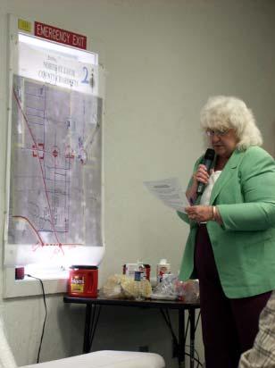
5 The Citizens Plans


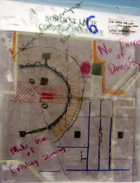
6
7 What We Heard Increase road corridors/improve circulation Widen Indrio Road Provide comprehensive greenway/water management system Retain ample amounts of agricultural lands Provide many shopping opportunities Locate new schools, churches, and emergency service stations Improve drainage systems Do not move Urban Service Boundary Maintain a rural lifestyle No increase in densities Extend Emerson Road to Imokolee (St. Lucie Boulevard) Create small town centers Connect greenways Architecture controls/guidelines Provide services to Lakewood Park Create a Dog Park


8 How The Master Plan Was Created: Public Process Saturday February, 7th Through Friday February 13 th

9 County Line The Study Area New Kings Hwy Indrio Road Kings Hwy C- 25 Canal
10 Setting the Stage Practical Assumptions for Growth in the Region: There is an increasing demand for housing (nearly 60% increase (+/- 50,000 households) by 2020 Retail and Shopping demands will also increase dramatically (nearly 1.5 million s.f. in study area) Increasing Demand for Real Communities NOW is the Time to Decide how You will Grow
11 Setting the Stage Ground Rules which are Crucial for achieving sustainable growth: Do NOT Move the Urban Services Boundary 1 st Priority Infill areas w/in U.S.B Do NOT Simply Up-Zone Offer Incentives for Good Growth Establish detailed Criteria defining Good Growth
12 The Citizens Master plan
13 Key Components of the Plan Circulation (Road Network/Connectivity) Infrastructure (water, sewer, drainage, etc) Schools and Public Facilities Parks and Open Space Retail Considerations The Neighborhoods Concerns about Density Zoning, Land Uses, and Entitlements

14 Circulation Types of Trips


15 Circulation Trip Assignments in Two Patterns of Development Conventional Sparse Hierarchy Dense Network Traditional
16 2000: 112 (74) 2000: 62 (116) 2018: 715 (480) 2018: 418 (793) 2000: 348 (266) 2000: 210 (362) 2000: 141 (173) Emerson 2018: 481 (851) Kings Hwy. 2018: 537 (922) 2000: 87 (166) 2018: 328 (418) 2018: 168 (255) Indrio Rd. 2000: 165 (189) 2018: 400 (375) Existing & Proposed Traffic Volumes Under Existing Network Circulation 2000: 199 (167) 2018: 615 (464) 2000: 348 (266) 2018: 481 (851) 2000: 138 (106) 2018: 255 (157) 2000: 105 (233) 2018: 374 (838) 2000: 210 (362) 2018: 537 (922)
17 2000: 112 (74) 2000: 62 (116) 2018: 715 (480) 2018: 418 (793) 2000: 348 (266) 2000: 210 (362) 2000: 141 (173) Emerson 2018: 481 (851) Kings Hwy. 2018: 537 (922) 2000: 87 (166) 2018: 328 (418) 2018: 168 (255) Indrio Rd. 2000: 165 (189) 2000: 138 (106) 2018: 400 (375) 2018: 255 (157) 2000: 199 (167) 2000: 105 (233) 2018: 615 (464) 2018: 374 (838) 2000: 348 (266) 2018: 481 (851) Existing & Proposed Traffic Volumes With Emerson Extension 2000: 210 (362) 2018: 537 (922)

18 Circulation The Importance of Network
19 Circulation

20 Circulation Hourly lane capacity Individual lanes on two-lane streets are most efficient; therefore, two 2-lane streets have more total capacity then one 4-lane street


21 Circulation Main Street Cityplace West Palm Beach
22 Circulation Main Street Cityplace West Palm Beach

23 Transition Areas Village Entrance Feature Zone 3: Enter Village 11 travel lanes 2 curb & gutter Sidewalks Regimented tree plantings Zone 3 Approx. 500 Zone 2: Announce Village 11 travel lanes 2 paver at edge of travel lane More structured landscaping Zone 2 Approx. 500 Stabilized Turf Shoulder Zone 1: Reduce Speeds 12 travel lanes 1 paver at edge of travel lane Rural landscaping treatment Zone 1 Approx. 600

24 Bike/Trail Systems Circulation


25 Infrastructure Natural Linear Reservoir/Flow-way ( polishes water prior to entering Taylor Creek) Conventional Detention/Retention (has Planning & Intensity Implications)
26 Sewer Infrastructure


27 Schools and Public Facilities


28 Schools and Public Facilities

29 Parks and Open Space

30 Parks and Open Space

31 Retail Considerations Robert Gibbs ~ Gibbs Planning Group

32 Retail Considerations Trade Area

33 Retail Considerations Existing Transportation

34 Retail Considerations Commercial Hot Zones

35 Retail Considerations Average Median Incomes

36 Retail Considerations Wal-Mart

37 Retail Considerations Regional Centers

38 Retail Considerations Proposed Transportation Network
39 Retail Considerations Estimated Retail Market Demand*» Corner Stores 4 stores 10 stores 16 Convenience 1 center 3 groups 8 centers Neighborhood 1 center 4 centers 5 centers Village Center 10,000 sf 160,000 sf 200,000 sf Town Center 20,000 sf 200,000 sf 400,000 sf Warehouse Type 30,000 sf 200,000 sf 300,000 sf * Based upon 40,000 additional residential dwellings ( 32 neighborhoods) by 2020

40 Retail Considerations

41 Retail Considerations


42 Retail Considerations Corner Store 3-5K Convenience Center 10-25K Warehouse Center million s.f. Neighborhood/ Village Center K Lifestyle Center 2-300K

43 Retail Considerations


44 Retail Considerations N.O.R.C. Naturally Occurring Retirement Community

45 Concerns about Density


46 Concerns about Density Holiday Pines 1.5 du/acre Portofino Shores 2.78 du/acre Lakewood Park 2.5 du/acre Emerson Estates 3 du/acre

47 Concerns about Density 6 du/acre (average density for traditional towns and neighborhoods = 7.5 du/acre)


48 Zoning, Land Uses, and Entitlements Comprehensive Plan Future Land Use Zoning Entitlements

49 Zoning, Land Uses, and Entitlements 1 Unit/Acre = 12,000 units


50 The Neighborhoods


51 The Neighborhoods Indrio and Dixie


52 The Neighborhoods North Dixie & 713
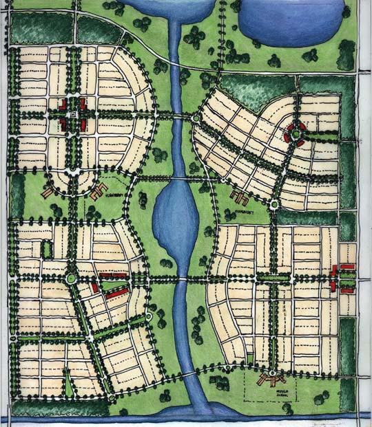
53 The Neighborhoods Southern Neighborhood A Hamlet


54 The Neighborhoods The Village Center

55 The Neighborhoods The Town Center

56 The Neighborhoods The Town Center

57 The Neighborhoods The Town Center

58 The Neighborhoods The Northwest Neighborhoods

59 The Neighborhoods The Northwest Neighborhoods

60 The Neighborhoods The Northwest Neighborhoods

61 The Neighborhoods The Northwest Neighborhoods
62 The Dilemma

63 The Dilemma
64 Strategies for Implementation
65 Implementation Strategies County Line Indrio Road Kings Hwy C- 25 Canal 1). HOLD THE LINE!!! but allow for extension of services to projects that implement the vision
. DON T GIVE IT AWAY!!!")
66 Implementation Strategies 1). DON T GIVE IT AWAY!!!
67 Implementation Strategies 2). USE THE VALUE-GAP!!!
.")

68 Implementation Strategies 3). Transfer of Development Rights
69 Implementation Strategies 3-Pronged Approach #1 Build As-Of-Right County Line 1-Acre Lots No Services Indrio Road No Density Increases 7,000 lots on well and septic Kings Hwy C- 25 Canal
70 Implementation Strategies 3-Pronged Approach #2 Transfer/Sell Development Rights to Urban Service Areas County Line Indrio Road Kings Hwy C- 25 Canal
71 Implementation Strategies 3-Pronged Approach #2 Transfer/Sell Development Rights to Urban Service Areas Provide Development Incentives for Transfer County Line Indrio Road Kings Hwy C- 25 Canal
72 Implementation Strategies 3-Pronged Approach #2 Transfer/Sell Development Rights to Urban Service Areas Provide Development Incentives for Transfer County Line Indrio Road Full Right to Services Limited Density Increases provided for transfer Kings Hwy * Preservation of Rural Lands C- 25 Canal
73 Implementation Strategies 3-Pronged Approach #3 Transfer/Sell Development Rights outside of Urban Service Areas County Line Indrio Road Kings Hwy C- 25 Canal
74 Implementation Strategies 3-Pronged Approach #3 Transfer/Sell Development Rights outside of Urban Service Areas Provide Development Incentives for Transfer County Line Indrio Road Possibility of Services Limited Density Increases provided for transfer Kings Hwy C- 25 Canal
75 Implementation Strategies 3-Pronged Approach #3 Transfer/Sell Development Rights outside of Urban Service Areas Provide Development Incentives for Transfer County Line Indrio Road Possibility of Services Limited Density Increases provided for transfer Kings Hwy GREAT Preservation of Rural Lands!!! C- 25 Canal
76 Implementation Strategies 3-Pronged Approach #1 Build As-of-Right 1 Acre Lots No Services No Increase in Density #2 Transfer to Inside Urban Service Areas Incentives for Transfer Full Right to Services Limited Density Increases #3 Transfers Outside of the Urban Service Areas Incentives for Transfer Potential for Services Limited Density Increases Must Comply with Specific Development Design Guidelines

77 Implementation Strategies Development Design Guidelines Neighborhood Scale Neighborhood Center

78 Implementation Strategies Development Design Guidelines Public Open Spaces Network of Streets Mix of Uses Civic and Public Buildings
79 Implementation Strategies Other Recommendations: Industrial Uses along Indrio Road Review of Long-Term Future of Airport Preservation of Uplands A Dog Park, Round-abouts, Trail Design, Architecture, Signage, etc.
80 Implementation Strategies Other Recommendations: Preservation of Uplands A Dog Park?
81 What s Next? Present Master Plan and Strategies during Commission Workshop Refine Recommendations and Develop Final Report Return (10-12 weeks) with Final Report Final Presentation Adopt the Plan as the Vision of the Community Prioritize charrette recommendations Incorporate recommendations into Comp. Plan/Zoning Amendments And At The Same Time.. Continue receiving critique and recommendations from Community
82 How Did We Do? Let us know tonight and over the next few weeks!!
83 The Team Treasure Coast Regional Planning Council A+S Architects & Planners (Derrick Smith, Principal) Arx Solutions In. (Patricdio Navarro, Daniel Baschkier, Lucio Sanyuan, Gonzalo Navarro) Gibbs Planning Group (Robert Gibbs) Town Planners: Dan Cary, Shailendra Singh, Sita Singh, Jess Linn, Maria DeLeon Fleites, Steven Fett, Natasha Alfonso, Peter Quintanilla, Anthea Gianniotes
84
85
86
87

88 Existing Condition Indrio Road Looking East

89 Existing Condition Kings Road
90 Existing Condition U.S. 1
91 Concerns about Density Density v. Intensity Density= 1 du/acre Low intensity Density= 1 du/acre Med. intensity Density= 1 du/acre High intensity
DOMINION BOULEVARD CORRIDOR STUDY AND ECONOMIC DEVELOPMENT STRATEGIC PLAN A MODEL FOR CHESAPEAKE S FUTURE
 DOMINION BOULEVARD CORRIDOR STUDY AND ECONOMIC DEVELOPMENT STRATEGIC PLAN A MODEL FOR CHESAPEAKE S FUTURE Overview I. Draft Plan Process II. Draft Plan Overview a. Market Analysis b. Master Land Use Plan
Secrest Short Cut and Monroe Expressway Small Area Plan AUGUST 29, 2018
 Secrest Short Cut and Monroe Expressway Small Area Plan AUGUST 29, 2018 Background and Process Monroe Expressway will be open by the end of 2018 Union County and Indian Trail identified a need to revisit
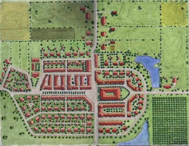
One of the components of the sustainable, traditional neighborhood is the neighborhood center.
 One of the components of the sustainable, traditional neighborhood is the neighborhood center. The neighborhood center defines a community s identity and is the place for events, leisure activities, public
VILLAGE & TOWN OF BERGEN: COMPREHENSIVE PLAN
 VILLAGE & TOWN OF BERGEN: COMPREHENSIVE PLAN CPC Public Hearing April 21, 2016 History 1996 Comprehensive Plan Comprehensive Plan Update Committee Consultant (LaBella Associates): December 2014 Residents
TREASURE COAST REGIONAL PLANNING COUNCIL M E M O R A N D U M. To: Council Members AGENDA ITEM 5H
 TREASURE COAST REGIONAL PLANNING COUNCIL M E M O R A N D U M To: Council Members AGENDA ITEM 5H From: Date: Subject: Staff October 17, 2008 Council Meeting Local Government Comprehensive Plan Review Draft
What Does It Take To Create A Town Center?
 What Does It Take To Create A Town Center? Context, Design, and Process The Prince Frederick Master Plan Update 1 Background and Overview A Brief History of Town Centers in Calvert County 2 Background
INDEPENDENCE BOULEVARD AREA PLAN. June 24, 2008
 INDEPENDENCE BOULEVARD AREA PLAN Public Meeting #1 June 24, 2008 Tonight s Agenda Introduction Welcome and Ground Rules Overview Presentation Purpose of the Plan What Brings Us Here? A Tour of the Corridor
CITY OF BOYNTON BEACH SE 1 ST STREET COMPLETE STREETS IMPROVEMENTS
 CITY OF BOYNTON BEACH SE 1 ST STREET COMPLETE STREETS IMPROVEMENTS N Project Location -Town Square -Villages at Ocean SE 1st St, between E Woolbright Rd and SE 2nd Ave Project Location -Boynton One -Publix
Micco Park Village Development
 FOR SALE Call For Pricing Micco Park Village Development Proposed Project Property Details Micco Park Village Development PRICE Call For Pricing A monumental development opportunity of a lifetime! The
12/9/2013. HOLLYWOOD/PINES CORRIDOR PROJECT AMPO 2013 Annual Conference October 24, Our Perspective. Broward.
 HOLLYWOOD/PINES CORRIDOR PROJECT AMPO 2013 Annual Conference October 24, 2013 Our Perspective Broward Fort Lauderdale 1 Broward Metropolitan Planning Organization Fort Lauderdale Fort Lauderdale Skyline
4.1.3 LAND USE CATEGORIES
 4.1.3 LAND USE CATEGORIES a. City Center District The City Center District incorporates the existing character and mix of uses in downtown Belmont to encourage redevelopment and new development in keeping
SCTPO Project Summary September 2014
 A1A MULTIMODAL CORRIDOR PLANNING AND ENGINEERING ANALYSIS Florida Department of Transportation SCTPO Project Summary September 2014 PRESENTATION FOOTER Meeting Agenda What We Plan To Do Project Background
VILLAGE OF CLEMMONS PLANNING BOARD DRAFT STAFF REPORT
 VILLAGE OF CLEMMONS PLANNING BOARD DRAFT STAFF REPORT PETITION INFORMATION Docket # C-226 Staff Megan Ledbetter Petitioner(s) JBJH Properties, LLC Owner(s) JBJH Properties, LLC Subject Property 5892-49-1766
BROOKHILL NEIGHBORHOOD MODEL ZONING MAP AMENDMENT PREFACE TO APPLICATION
 BROOKHILL NEIGHBORHOOD MODEL ZONING MAP AMENDMENT PREFACE TO APPLICATION June 15, 2015 Revised: August 1, 2016 I. VISION Brookhill is a proposed community based upon the principles of Albemarle County
Today Land & People. Northeast Nampa Gateway District. Employment. Land Use Characteristics. Demographics. Current Zoning
 Today Land & People Employment Major employers include Saint Alphonsus, the College of Western Idaho, the Auto Mall, Sorrento Lactalis and Walmart. 3,004 jobs in 2010 (COMPASS-CIM 2040 TAZ data) 4,345
EXISTING COMPREHENSIVE PLAN
 EXISTING COMPREHENSIVE PLAN Town Center Land Use Element: V. LAND USE POLICIES Town Center Mercer Island's business district vision as described in "Your Mercer Island Citizen-Designed Downtown" was an
Presentation of the Staff Draft. July 17, 2014 SSRVP Team, Area 3
 Presentation of the Staff Draft July 17, 2014 SSRVP Team, Area 3 Presentation Overview Introduction Plan Framework Plan Recommendations Implementation Next Steps and Request for Public Hearing on September
Rezoning Petition Post-Hearing Staff Analysis February 5, 2019
 Rezoning Petition 2018-053 Post-Hearing Staff Analysis February 5, 2019 REQUEST Current Zoning: R-5 (single family), B-1 (neighborhood business), I-1 (light industrial), and I-2 (general industrial) Proposed
The petition proposes to rezone the site to allow all uses permitted in the B-1 (neighborhood business) district.
 district.") Rezoning Petition 2018-040 Pre-Hearing Staff Analysis June 18, 2018 REQUEST Current Zoning: R-17MF (multi-family residential) Proposed Zoning: B-1 (neighborhood business) LOCATION Approximately 0.38 acres
Rezoning Petition 2018-040 Pre-Hearing Staff Analysis June 18, 2018 REQUEST Current Zoning: R-17MF (multi-family residential) Proposed Zoning: B-1 (neighborhood business) LOCATION Approximately 0.38 acres
Urban Development Areas Bedford County
 5 Urban Development Areas Bedford County UDA Needs Profile: All UDAs Bedford County has designated two UDAs: areas just outside the Bedford City Limits (generally to the south and east of the city) and
TAC/CAC, TPO Project Update February 2016
 A1A MULTIMODAL CORRIDOR PLANNING AND ENGINEERING ANALYSIS Florida Department of Transportation TAC/CAC, TPO Update February 2016 PRESENTATION FOOTERT Meeting Agenda What We Plan To Discuss Background New
Proposed Comprehensive Plan Strategies DRAFT for discussion June 28, 2017
 Proposed Comprehensive Plan Strategies DRAFT for discussion June 28, 2017 Land Use Rural Areas Refine the Farm and Forest area (FF) Update FF boundaries to account for existing lots less than five acres
A. Selma Park, Davis Bay and Wilson Creek
 A. Selma Park, Davis Bay and Wilson Creek This waterfront neighbourhood consists of three separate community areas, linked by Highway 101, but with different character, land use patterns and future potential.
NORTH LAKE SPECIFIC PLAN AREA
 NORTH LAKE SPECIFIC PLAN AREA June 21, 2018 WELCOME Workshop Agenda Introduction Provide information about the program and introduce the team Background Information Share information about the North Lake
Cobb County Design Guidelines Mableton Parkway & Veterans Memorial Highway Community Design Workshop January 12, 2017
 Community Design Workshop January 12, 2017 Agenda Opening Remarks / Introductions Scope of Work Existing Conditions Key Issues / Opportunities VPS Summary Draft Vision & Goal Statement Implementation Concepts
What Pioneer Grove Will Look Like?
 The City of Deerfield Beach has embarked on a journey to create a new town center within the old heart of Deerfield Beach. The new town center is known as Pioneer Grove. Pioneer Grove will be Everybody
Public Open House #1
 Public Open House #1 TONIGHT S AGENDA Welcome Project Overview The Big Picture The Station Area The Analysis Thoughts about Future Change Breakout Group Discussions Summation / Next Steps Project Overview
Jackson Highway Master Plans
 Jackson Highway Master Plans West Jackson Highway Master Plan (PLNP2008-00240) Jackson Township Specific Plan (PLNP2011-00095) NewBridge Specific Plan (PLNP2010-00081) Mather South Community Master Plan
Obey Creek July 17, Vicinity Map. Concept Plan Submittal. No
 15/501 Fordham Blvd. 15/501 By-Pass To Downtown Chapel Hill Vicinity Map 0 1000 2000 FT Arlen Park DR. Bennett Road Mt. Carmel Church Rd. Southern Village Parkside Circle Market St. 15/501 Founder's Ridge
New Partners for Smart Growth Conference February 5, 2010
 Dan Stroh, Planning Director City of Bellevue Planning and Community Development Bellevue, WA New Partners for Smart Growth Conference February 5, 2010 Summary of Project Long-range plan update for Bel-Red
CHAPTER 7: VISION AND ACTION STATEMENTS. Noble 2025 Vision Statement
 CHAPTER 7: VISION AND ACTION STATEMENTS This chapter presents the vision, policy and action statements that transform the comprehensive planning study, an analysis of Noble s past, future trends and community
S.R.7/U.S.441 COLLABORATIVE THE COLLEGE OF CORRIDOR KNOWLEDGE
 S.R.7/U.S.441 COLLABORATIVE THE COLLEGE OF CORRIDOR KNOWLEDGE S.R.7 Corridor : A Sense of Place? ANYWHERE USA SR 7: Civilizing the Corridor Bad rules = Bad development! The SR 7 Collaborative A model for
ARTICLE 6: Special and Planned Development Districts
 ARTICLE 6: Special and Planned Development Districts 6-10 Traditional Neighborhood Development (TND) District 6-10.10 Purpose and Intent The Traditional Neighborhood Development (TND) District provides
7,600 Residential Units 1,700,000 SF Non-Res 300-Room ALF 300-Room Hotel University School, Park, Civic parcels 1,889 ac flow-way/preservation
 4,763 ac undeveloped long-term AG use Over 75% characterized by non-native & invasive species Has severely degraded habitat functions 11,565 of frontage along Northlake Blvd. 1,687 of frontage along Beeline
DRAFT Subject to Modifications
 DRAFT Subject to Modifications TREASURE COAST REGIONAL PLANNING COUNCIL M E M O R A N D U M To: Council Members AGENDA ITEM 7C8 From: Date: Subject: Staff January 20, 2017 Council Meeting Local Government
Beatties Ford Road & Mt. Holly-Huntersville Road Small Area Plan
 Beatties Ford Road & Mt. Holly-Huntersville Road Small Area Plan Town of Huntersville October 2005 Town of Huntersville Planning Department 101 Huntersville Concord Road Post Office Box 664 Huntersville,
City of Fort Lauderdale UPTOWN URBAN VILLAGE. Public Workshop December 7, 2016
 Public Workshop December 7, 2016 Workshop Agenda Introductions Project Presentation o o o History Project Scope/Timeline Character of Study Area o o o o Land Use Public Realm/Pedestrian Mobility Multimodal
6 November 10, 2010 Public Hearing APPLICANT: ZION TEMPLE MINISTRIES COGIC
 REQUEST: Conditional Use Permit (religious use) 6 November 10, 2010 Public Hearing APPLICANT: ZION TEMPLE MINISTRIES COGIC PROPERTY OWNER: PHYLLIS A. & ERNEST L. HUDSON TRUST STAFF PLANNER: Karen Prochilo
MORRISVILLE TRANSPORTATION PLAN TOWN COUNCIL PRESENTATION AUGUST 22, 2017
 TOWN COUNCIL PRESENTATION AUGUST 22, 2017 SCENARIO PLANNING CORRIDORS Town Hall Drive Baseline + 2 McCrimmon Parkway Baseline + 2 NC 54 Baseline + 2 7 subregion model runs determining carrying capacity
Public Meeting Final Recommendations August 8, 2013
 Public Meeting Final Recommendations August 8, 2013 Meeting Agenda 1. Existing Conditions 2. Plan Building Blocks & Process 3. The Plan Policies 4. What we heard 5. Next Steps Existing Conditions Existing
Fun Facts 2030 Population Projection 2,694,800 Or 994,800 New Residents By 2030 (PBC) Urban Redevelopment Area (URA)
 Urban Redevelopment Area (URA)") Palm Beach County Urban Redevelopment Area (URA) Addressing Redevelopment in Central Palm Beach County Friday September 15, 2006 Fun Facts 2030 Population Projection 2,694,800 Or 994,800 New Residents
Palm Beach County Urban Redevelopment Area (URA) Addressing Redevelopment in Central Palm Beach County Friday September 15, 2006 Fun Facts 2030 Population Projection 2,694,800 Or 994,800 New Residents
TREASURE COAST REGIONAL PLANNING COUNCIL M E M O R A N D U M. To: Council Members AGENDA ITEM 4B3
 Revision: 3-15-19 TREASURE COAST REGIONAL PLANNING COUNCIL M E M O R A N D U M To: Council Members AGENDA ITEM 4B3 From: Staff Date: March 8, 2019 Subject: Local Government Comprehensive Plan Review Draft
IMPLEMENTATION STRATEGIES. In This Chapter. Goals & Strategies 182 Project List 183 Future Land Use 186 CHAPTER 11 IMPLEMENTATION STRATEGIES
 In This Chapter Goals & Strategies 182 Project List 183 Future Land Use 186 11 IMPLEMENTATION STRATEGIES NORTH AUGUSTA, SC 2017 COMPREHENSIVE PLAN 179 Individual commitment to a group effort that is what
Tyvola & Archdale Transit Station Area Plan. May 15, 2008
 Tyvola & Archdale Transit Station Area Plan First Public Meeting May 15, 2008 Presentation Outline 1. Purpose and Process 2. Station Area Overview 3. Plan Recommendations Vision Land Use Transportation
Sorted citizen input comments in review of Blount County plans July, August, and September 2007
 Sorted citizen input comments in review of Blount County plans July, August, and September 2007 The following presents sorted citizen input comments from three sessions held in July, August and September
A. WHAT IS A GENERAL PLAN?
 I. Introduction A. WHAT IS A GENERAL PLAN? A general plan is the planning guideline for the future of a city. It contains goals and policies which regulate urban development, the protection of the natural
Draft Cary Community Plan Review Part 3: Shop, Engage, Serve, Special Area Plans, Other Updates. October 27, 2015 Police Department Training Room
 Draft Cary Community Plan Review Part 3: Shop, Engage, Serve, Special Area Plans, Other Updates Committee for the Future October 27, 2015 Police Department Training Room AGENDA 1. Welcome and Call to Order
Port Marigny TND Planning and Zoning Commission Workshop September 1, 2015 Preliminary Observations - David Bailey, AIA, AICP
 Planning and Zoning Commission Workshop September 1, 2015 Preliminary Observations - David Bailey, AIA, AICP Outline, per 8-27-15 Memorandum: 1. Background 2. General Observations 3. Comprehensive Plan
NEIGHBORHOOD DESIGN ELEMENT
 NEIGHBORHOOD DESIGN ELEMENT INTRODUCTION The following recommendations constitute an urban design oriented "neighborhood analysis" of Plantation. It is an optional Comprehensive Plan Element. The five
OPEN SPACE TYPES. SIZE 8 acres. SIZE 20 acres. SIZE 1 acre
 TYPICAL CHARACTERISTICS OPEN SPACE TYPES OPEN SPACE TYPES The neighborhood contains an extensive variety of open space types. Most of these spaces incorporate multiple uses and activities, so that each
STAFF SUMMARY FOR S17-02 SPECIAL USE PERMIT APPLICATION
 APPLICATION SUMMARY Case Number: S17-02 Request: STAFF SUMMARY FOR S17-02 SPECIAL USE PERMIT APPLICATION SUP application in order to develop a convenience food store. Applicant: Property Owner(s): Cindee
Rapid City Planning Commission Rezoning Project Report
 Rapid City Planning Commission Rezoning Project Report April 5, 2018 Item # 4 Applicant Request(s) Case # 18RZ008 Rezoning request from General Agricultural District to Low Density Residential District
Town of Avon Village Center. A New Village Center for Avon October, 2015
 Town of Avon Village Center A New Village Center for Avon October, 2015 A busy Avon Center approx. 1940 The Avon Town Center Study: In 2004 the Planning and Zoning Commission (PZC) undertook the Avon
4 January 11, 2012 Public Hearing APPLICANT:
 . 4 January 11, 2012 Public Hearing APPLICANT: MID-ATLANTIC AUTO PROPERTY OWNER: DZR, LLC STAFF PLANNER: Leslie Bonilla REQUEST: Conditional Use Permit (truck rental, automobile service, and automotive/bulk
Rezoning Petition Pre-Hearing Staff Analysis March 19, 2018
 Rezoning Petition 2017-171 Pre-Hearing Staff Analysis March 19, 2018 REQUEST Current Zoning: R-3 (single family residential) Proposed Zoning: MX-2 (INNOV) (mixed used, innovative) with five-year vested
Silver Line CPAM UPDATE. Transportation and Land Use Committee October 14, 2016
 Silver Line CPAM UPDATE Transportation and Land Use Committee October 14, 2016 Purpose Recap Project History and Map Changes Provide Overview of CPAM Components Discuss Transportation Impacts Discuss Fiscal
City of Heath. Town Center Concept
 In the give-and-take of getting projects designed, financed, and approved, the famous refrain from the film Field of Dreams is heard often: if you build it, they will come. From the perspective of the
Old Town Neighborhoods Plan. Choices Event Wednesday, December 9, 2015
 Old Town Neighborhoods Plan Choices Event Wednesday, December 9, 2015 Agenda 6:00 6:10 p.m. Welcome + Sign In 6:10 6:30 p.m. Presentation 6:30 8:00 p.m. Workshop + Open House Seeking your input on: Neighborhood
A citizen s guide to the. Comprehensive Plan. City of Lakeville, Minnesota 1
 A citizen s guide to the Comprehensive Plan 2008 City of Lakeville, Minnesota 1 Introduction The City of Lakeville completed an update of its Comprehensive Plan in 2008. A comprehensive plan is a tool
Communities Plan. Parkland-Spanaway-Midland. LUAC Review of Draft Policies
 Parkland-Spanaway-Midland Communities Plan LUAC Review of Draft Policies Presented by: Tiffany O Dell, Senior Planner Planning & Public Works Tiffany.Odell@co.pierce.wa.us 253-798-6859 November 1, 2017
Rezoning Petition Final Staff Analysis June 18, 2018
 Rezoning Petition 2018-028 Final Staff Analysis June 18, 2018 REQUEST Current Zoning: MX-1 LLWPA (mixed use district, Lower Lake Wylie Protected Area), R-3 LLWPA (single family residential, Lower Lake
NORTH CLAYMONT AREA MASTER PLAN COMMUNITY WORKSHOP #1 FEBRUARY 3, 2016
 NORTH CLAYMONT AREA MASTER PLAN COMMUNITY WORKSHOP #1 FEBRUARY 3, 2016 1. Introduction To the team and to the Plan Planning Partners The Claymont Community WILMAPCO New Castle County Claymont Renaissance
Onondaga County Sustainable Streets Project. Onondaga County Planning Federation June 7, Onondaga County Sustainable Streets Project 1
 Onondaga County Sustainable Streets Project Onondaga County Planning Federation June 7, 2012 Onondaga County Sustainable Streets Project 1 Sustainable Streets 1. Introduction to the SMTC 2. Sustainable
Sam Furr and McCord Road Huntersville, North Carolina
 108± Acres of Sam Furr and McCord Road Huntersville, North Carolina NorthCross Shopping Center Land for Sale 108 Acres located in northeast Huntersville wth extensive frontage along both Sam Furr Road
The Floyds Fork Area Study A Framework for Growth
 The Floyds Fork Area Study A Framework for Growth 2 21 st Century Parks Master Plan: The Fork 3 Neighborhood Development Area Policy Recommendations 1. Create incentives to promote infill of existing development
Future Land Use and Transportation
 Planning & Zoning Board Workshop Comprehensive Plan for Village of Estero Future Land Use and Transportation April 6, 2017 January Kick-off Meeting Public Input What do you like about Estero? Location
DRAFT PLAN PRESENTATION
 DRAFT PLAN PRESENTATION 1.23.2018 AGENDA Process Project Schedule Results from Visioning Workshop Draft Plan Highlights Concept Plans Feedback Next Steps PROJECT SCHEDULE KICK-OFF WORKSHOP August 29 th
Rezoning Petition Final Staff Analysis May 21, 2018
 Rezoning Petition 2018-010 Final Staff Analysis May 21, 2018 REQUEST Current Zoning: I-2 (general industrial) Proposed Zoning: TOD-M (transit oriented development, mixed-use) LOCATION Approximately 0.25
Clarksburg Master Plan Concept and the Clarksburg Town Center. Planning Regulating Building
 Master Plan Concept and the Town Center Planning Regulating Building Overview with CTC PHED T&E Dec 12, 2011 outline Location Master Plan Concept Staging Approved Preliminary Plans Infrastructure Town
MEMORANDUM AGENDA ITEM #6c
 South Florida Regional Planning Council MEMORANDUM AGENDA ITEM #6c DATE: FEBRUARY 1, 2010 TO: FROM: SUBJECT: COUNCIL MEMBERS STAFF CITY OF PARKLAND PROPOSED COMPREHENSIVE PLAN AMENDMENT (ALTERNATIVE REVIEW)
DRAFT. Urban Development Areas Fairfax County. UDA Needs Profile: Tysons Corner 13% Location Characteristics. Socio-Economic Characteristics
 14 Urban Development Areas Fairfax County UDA Needs Profile: Tysons Corner Tysons Corner is located in Fairfax County, surrounded by the town of McLean to the east and Vienna on the west along I-495, the
CHARLES PUTMAN CHARLES PUTMAN AND ASSOCIATES, INC
 MEMORANDUM CHARLES PUTMAN & ASSOCIATES, INC. LAND DEVELOPMENT CONSULTANTS PLANNING ZONING PERMITTING 4722 NW Boca Raton Boulevard, Suite C-106 Boca Raton, Florida 33431 Phone: 561/994-6411 FAX: 561/994-0447
Northwest Rail Corridor and US 36 BRT Development Oriented Transit Analysis 4.4 STATION AREA FINDINGS
 4.4 STATION AREA FINDINGS Each station is different, and each one requires a separate set of recommendations based on the vision for the site. This section outlines an initial TOD strategy and recommendations
General Location Annex, Rezone & Preliminary Plat Lansdowne Addition, Unit Three
 NEWFOUNDLAND I-5 Agricultural District Subject Site SUNDANCE ANDERSON Single Family Residential CHRISTY PUD Agricultural District Highway Business General Location Annex, Rezone & Preliminary Plat Lansdowne
MONTGOMERY COUNTY METRO STATION AREA DESIGN CHARRETTE
 MONTGOMERY COUNTY METRO STATION AREA DESIGN CHARRETTE Shady Grove Metro Station Area Charrette Closing Presentation October 25-28, 2000 MONTGOMERY COUNTY, MD M-NCPPC Design Collective, Inc. Architects
2. Form and Character. 2.1 Introduction. 2.2 The Downtown Addition Plan. 2.1 Introduction
 2.1 Introduction 2.1 Introduction This section of the Specific Plan describes and illustrates the desired form, character and uses of the Downtown Addition and explains the underlying design principles.
This page left intentionally blank.
 July 2012 This page left intentionally blank. Table of Contents Appendix A : Project Development Checklist Appendix B: At-Grade Rail Crossings Appendix C: Maintenance and Operations Examples Appendix D:
Courtice Main Street Study Community Vision Workshop PLANNING SERVICES DEPARTMENT
 Courtice Main Street Study Community Vision Workshop PLANNING SERVICES DEPARTMENT July 22, 2009 Tonight s Meeting 7:00 pm Introduction David Crome, Director of Planning 7:05 Presentation Stasia Bogdan,
Chapter 6: Community Character
 Chapter 6: Community Character The term "community character" covers a broad spectrum of concerns. First and foremost, community character is a visual concept. In Long Grove, however, community character
TIRZ 17/Redevelopment Authority Capital Improvements Plan Projects
 Gessner Widening: T-1701 What: Widen the road from a six-lane divided boulevard to an eight-lane divided boulevard street section, increase turn lanes, update traffic signal system, improve drainage by
Section 4 BUILDING THE MASTER PLAN
 The Master Plan 33 Section 4 BUILDING THE MASTER PLAN Figure 4:1. A collaborative effort characterized the two design workshops sponsored by DISC to create hypothetical Master Plans for the Towers Property
Pine Island Road Corridor Master Plan
 RECOMMENDED DEVELOPMENT PLAN Figure 9: Del Prado Village District Conceptual Framework The Conceptual Framework (Figure 8) for development of the Pine Island Corridor is to encourage mixed-use development
Town of Peru Comprehensive Plan Executive Summary
 Town of Peru Comprehensive Plan Executive Communities that plan grow by choice, not by chance. A plan makes growth thoughtful, understandable, and predictable. A plan shows that a community is managing
12 February 9, 2011 Public Hearing APPLICANT: WILDLIFE RESPONSE, INC.
 12 February 9, 2011 Public Hearing APPLICANT: WILDLIFE RESPONSE, INC. PROPERTY OWNER: CITY OF VIRGINIA BEACH REQUEST: Conditional Use Permit (Wildlife Rehabilitation Center) STAFF PLANNER: Karen Prochilo
E. RURAL COMMERCIAL/INDUSTRIAL PARK MODEL
 E. RURAL COMMERCIAL/INDUSTRIAL PARK MODEL 1. PURPOSE The purpose of the Rural Commerce/Industrial Park Model is to provide parameters within which a grouping of business buildings with parking, loading
Wadsworth Boulevard S TAT I O N A R E A P L A N
 Wadsworth Boulevard S TAT I O N A R E A P L A N City of Lakewood Adopted November, 2006 The Vision The City of Lakewood s overall vision is to transform the area around the light rail station into a mixed-use
RESOLUTION NO R
 e e RESOLUTION NO R04 0054 BE IT RESOLVED by the Mayor and City Council ofthe City ofpapillion that The Papillion Comprehensive Plan is hereby amended to incorporate the Option A Future Land Use Map Transportation
3.10 LAND USE SETTING PROJECT SITE EXISTING LAND USE DESIGNATIONS AND ZONING. General Plan Land Use Designations.
 This section of the Draft EIR addresses the existing land uses on and adjacent to the project site and discusses the potential impacts of the proposed project on existing land uses. Key issues addressed
It Takes A Village.. Preserving Rural Character In Standish
 It Takes A Village.. Preserving Rural Character In Standish A Public Workshop Hosted by Conservation and Open Space Plan Committee & Standish Corner Village Implementation Committee June 12, 2008 Desired
Staff Report and Recommendation
 Community Planning and Development Planning Services 201 W. Colfax Ave., Dept. 205 Denver, CO 80202 p: 720.865.2915 f: 720.865.3052 www.denvergov.org/cpd TO: City Council Neighborhoods and Planning Committee
Staff Report to the North Ogden City Planning Commission
 Staff Report to the North Ogden City Planning Commission SYNOPSIS / APPLICATION INFORMATION Application Request: Concept review on a legislative application to rezone land located at approximately 1750
INDEPENDENCE BOULEVARD AREA PLAN
 INDEPENDENCE BOULEVARD AREA PLAN Public Meeting October 28, 2008 Tonight s Agenda Introduction 4:00 4:05 Tom Warshauer Presentation 4:05 5:00 Blake Drury Group Exercises 5:00 5:50 All Wrap Up & Next Steps
Review of Opportunity Area C Draft Comprehensive Plan and Draft BOS Follow-On Motions. Special Working Group Meeting March 4, 2015
 Review of Opportunity Area C Draft Comprehensive Plan and Draft BOS Follow-On Motions Special Working Group Meeting March 4, 2015 The slides that follow identify where the draft Comprehensive Plan has
TREASURE COAST REGIONAL PLANNING COUNCIL M E M O R A N D U M. To: Council Members AGENDA ITEM 5I
 TREASURE COAST REGIONAL PLANNING COUNCIL M E M O R A N D U M To: Council Members AGENDA ITEM 5I From: Date: Subject: Staff December 12, 2008 Council Meeting Local Government Comprehensive Plan Review Town
Atlanta BeltLine. Subareas 9 & 10. Master Plan Updates. March 26, Washington Park Jamboree 1
 Atlanta BeltLine Subareas 9 & 10 Master Plan Updates March 26, 2018 Washington Park Jamboree 1 22 miles, connecting 45 neighborhoods 22 MILES of transit 46 MILES of streetscapes and complete streets 33
LAND USE DESIGNATIONS AND ZONING CLASSIFICATIONS
 LAND USE DESIGNATIONS AND ZONING CLASSIFICATIONS One of the most significant issues addressed within the community plan process is land use. How land is utilized within a community directly affects the
Executive Summary. NY 7 / NY 2 Corridor
 Executive Summary NY 7 / NY 2 Corridor Transportation and Land Use Study December 2005 Prepared for: Town of Colonie Capital District Transportation Committee Prepared by: Introduction: Land use decisions
Westbound: A One-day Exploration of Growth
 Westbound: A One-day Exploration of Growth Frog Pond Area 2018 UGB Expansion Proposal June 13, 2018 Growing Out: UGB Asks Four cities submitted proposals to expand greater Portland s urban footprint by
Courthouse East vision and policy plan
 August 2017 Courthouse East vision and policy plan Virginia Beach, Virginia 2017 URBAN DESIGN ASSOCIATES SITE PLANNING APPROACH 10-minunte walk from the Courthouse COURTHOUSE EAST IN THE ITA VICINITY Site
Independence Boulevard Area Plan Planning Committee Public Comment May 18, 2010
 Independence Boulevard Area Plan Planning Committee Public Comment May 18, 2010 Presentation Outline Focus on Key Recommendations within Draft Plan Plan Purpose and Development Process Draft Plan Policies