Urban Infrastructure Design and Heat Vulnerability
|
|
|
- Joella Horton
- 5 years ago
- Views:
Transcription
1 Urban Infrastructure Design and Heat Vulnerability Rethinking Infrastructure in Mesa, Arizona A project by Arizona State University s Spring 2015 Urban Infrastructure Anatomy and Sustainable Development Course 28 April 2015
2 Urban Infrastructure Anatomy and Sustainable Development CEE598: Civil, Environmental, & Sustainable Engineering PUP598: Geography and Urban Planning SOS598: School of Sustainability CON252: Construction Methods, Materials, and Equipment Spring 2015 CEE/SOS/PUP 598 April 28 Mitigating Heat Vulnerability in Mesa, Arizona Slide 2
3 Maricopa County Population Population Growth 9,000,000 8,000,000 7,000,000 6,000,000 5,000,000 4,000,000 3,000,000 2,000,000 1,000,000 0 Spring 2015 CEE/SOS/PUP 598 April 28 Mitigating Heat Vulnerability in Mesa, Arizona Slide 3

4 Spring 2015 CEE/SOS/PUP 598 April 28 Mitigating Heat Vulnerability in Mesa, Arizona Slide 4
.")
5 Source: S Harlan, J Declet-Barreto, W Stefanov, and Diana Petitti, 2013, Neighborhood Effects on Heat Deaths: Social and Environmental Predictors of Vulnerability in Maricopa County, Arizona, Environmental Health Perspectives, 121(2). Spring 2015 CEE/SOS/PUP 598 April 28 Mitigating Heat Vulnerability in Mesa, Arizona Slide 5
6 120 Maricopa County Heat-Associated Deaths Maricopa County, 2013, Heat-Associated Deaths in Maricopa County, AZ, Hurricane Sandy: 273 deaths Spring 2015 CEE/SOS/PUP 598 April 28 Mitigating Heat Vulnerability in Mesa, Arizona Slide 6
7 More Frequent Extreme Heat Events Extreme heat events are associated with increased morbidity and mortality. Under climate change, extreme heat events are expected to become more frequent, more severe, and longer-lasting. MARICOPA - RCP 2.6: % increase; RCP 4.5: % increase; RCP 8.5: % increase. M Bartos and M Chester, 2014, "Assessing Future Extreme Heat Events at Intra-Urban Scales: A Comparative Study of Phoenix and Los Angeles", Arizona State University Report No. ASU-CESEM-2014-WPS Spring 2015 CEE/SOS/PUP 598 April 28 Mitigating Heat Vulnerability in Mesa, Arizona Slide 7
 Will develop cost estimations of infrastructure changes Spring 2015 CEE/SOS/PUP 598 April 28 Mitigating Heat Vulnerability in Mesa, Arizona Slide")
8 Project Overview TRANSPORTATION Key Amenities NEIGHBORHOODS BUILDINGS Land Uses Transition Projects URBAN INFRASTRUCTURE ANATOMY Materials Pallet Vegetative Shading Structural Shading ENVIRONMENT SOCIAL CONSTRUCTION MATERIALS & METHODS (CON 252) Will develop cost estimations of infrastructure changes Spring 2015 CEE/SOS/PUP 598 April 28 Mitigating Heat Vulnerability in Mesa, Arizona Slide 8

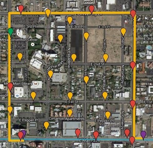
9 SITE EXISTING LIGHT RAIL LIGHT RAIL EXTENSION Spring 2015 CEE/SOS/PUP 598 April 28 Mitigating Heat Vulnerability in Mesa, Arizona Slide 9
10 35 Acres Spring 2015 CEE/SOS/PUP 598 April 28 Mitigating Heat Vulnerability in Mesa, Arizona Slide 10

11 Neighborhoods & Buildings Core Values - Assets within the City of Mesa Spring 2015 CEE/SOS/PUP 598 April 28 Mitigating Heat Vulnerability in Mesa, Arizona Slide 11
12 Neighborhoods & Buildings Key transitions that can enable a Sustainable Community Spring 2015 CEE/SOS/PUP 598 April 28 Mitigating Heat Vulnerability in Mesa, Arizona Slide 12
13 Neighborhoods & Buildings Overview Key Existing Neighborhood Components prime for improvement General Land Areas that could improve the local built environment Specific Spaces that can serve to enhance the community Unique transformational development projects that contribute towards SOS Aspects of building composition that relate to the Health of communities Spring 2015 CEE/SOS/PUP 598 April 28 Mitigating Heat Vulnerability in Mesa, Arizona Slide 13
14 Neighborhoods & Buildings Goals Promote Community Development Projects that reinforce local values Improve the local Environment through Heat mitigation strategies Encourage Rethinking of the Right of Way to reduce heat and increase safety Discuss alternative building compositions that could enhance quality of life Recommendations for addressing health of communities through materials Spring 2015 CEE/SOS/PUP 598 April 28 Mitigating Heat Vulnerability in Mesa, Arizona Slide 14
15 Neighborhoods & Buildings Key components that can be leveraged to reduce heat exposure Spring 2015 CEE/SOS/PUP 598 April 28 Mitigating Heat Vulnerability in Mesa, Arizona Slide 15
16 Neighborhoods & Buildings Urban Community Enhancements Opportunities within our project scope represent just a fraction of the cities areas to encourage investment mixed use buildings consolidate parking providing shade cleaner energy production cooling refuge areas enhanced amenities safety and security new building forms proper material pallets Spring 2015 CEE/SOS/PUP 598 April 28 Mitigating Heat Vulnerability in Mesa, Arizona Slide 16
17 Neighborhoods & Buildings Neighborhood Transformations Major New Developments Civic Enhancements Prime Adaptive Parcels Prime Adaptive Blocks Existing Public Transit Micro Climate Corridor Pedestrian Precession Traffic Calming Modes Exhaust Canopy s Spring 2015 CEE/SOS/PUP 598 April 28 Mitigating Heat Vulnerability in Mesa, Arizona Slide 17
18 Neighborhoods & Buildings Unique Development Projects w/n project boundaries NWC of project area for adaptive commercial use Mesa Center multifunctional canopy's (shade energy shelter) Main street revitalization and adaptive land uses Intersection prototypes for exhausting emissions and heat that create areas of refuge for the public T T Hibbert (NS) New developments and street design (shade vege h20 access) 1st street (EW) traffic calming and multi-modal paths Spring 2015 CEE/SOS/PUP 598 April 28 Mitigating Heat Vulnerability in Mesa, Arizona Slide 18


19 Neighborhoods & Buildings Prototype for Mixed-Use Commercial Spaces Location - NWC of project area SEC of university and center Reality that parking is a powerful force in our auto dominated region of Maricopa county Alternative response for a prime parcel could be a building typology that responds to local needs Flexibility of retail spaces and commercial offices while supporting vehicle related functions such as food trucks pop up markets and even overflow parking Spring 2015 CEE/SOS/PUP 598 April 28 Mitigating Heat Vulnerability in Mesa, Arizona Slide 19


20 Neighborhoods & Buildings Giles Spaces - Mixed-Use Community Areas Location Mesa Convention Center Approx. size 3.6 acres Est. cost 5.5 million Municipally owned property ROI Est. at 17 years Opportunity to provide areas of refuge through public open space that could showcase amenities under solar shading Spring 2015 CEE/SOS/PUP 598 April 28 Mitigating Heat Vulnerability in Mesa, Arizona Slide 20


21 Neighborhoods & Buildings Example New Developments along Main street Spring 2015 CEE/SOS/PUP 598 April 28 Mitigating Heat Vulnerability in Mesa, Arizona Slide 21


22 Neighborhoods & Buildings Example Prototypes for Street Level enhancements Spring 2015 CEE/SOS/PUP 598 April 28 Mitigating Heat Vulnerability in Mesa, Arizona Slide 22


23 Neighborhoods & Buildings c Material strategies for reducing heat Using light colors and alternative envelopes such as louvers we can reduce the heat being absorbed and radiated at a meso-scale Spring 2015 CEE/SOS/PUP 598 April 28 Mitigating Heat Vulnerability in Mesa, Arizona Slide 23


24 Neighborhoods & Buildings Representation of heat lost through building components approximately 40% of air loss/gain originates from the envelope Tony Woods Air-tight buildings,2005;richard S. Duncan, Phd, PE The Role of Air Sealing Spring 2015 CEE/SOS/PUP 598 April 28 Mitigating Heat Vulnerability in Mesa, Arizona Slide 24

25 Alternative Material Recommendations EXISTING/ CONVENTIONAL 1. Bricks Walls $40/sq. ft. 2. Concrete - Based of Portland Cement 3. Paint 4. Wood products 5. Lighting 6. Windows regular glazing 7. Glazing $12 per sq. ft. 8. Roof-absorbance HVAC coupled with min req d insulation 10. Flooring - Regular Carpets 11. Energy codes IECC UPGRADE/ SUSTAINABLE 1. CMU with Brick veneer $23 per sq. ft. 2. Fly ash/slag based concrete - More Durable and slightly less expensive by 0.5-1$ per ton 3. Low-emitting & Recycled paint can cost $3 less/gallon 4. Certified Wood door costs is $150 less expensive 5. Solar tubes and LED lighting 6. Optimized wall to window ratio, U-factor 0.31 & Shading Coefficient of Spandrel glass $18 per sq. ft. 8. Cool/White Roofs - Absorbance of Highly efficient Active system Integrated with Passive cooling (Solar chimney, Cooling towers & fans) 10. Carpets with recycled contents costs $15 per yard less than traditional carpet 11. ASHRAE has higher efficiency (10% higher R-Value) Spring 2015 CEE/SOS/PUP 598 April 28 Mitigating Heat Vulnerability in Mesa, Arizona Slide 25

26 Neighborhoods & Buildings Building Diagram for Sustainable Elements img credit: Snohetta architects Spring 2015 CEE/SOS/PUP 598 April 28 Mitigating Heat Vulnerability in Mesa, Arizona Slide 26
 Table below shows Energy Efficiency measured in a Building prototype showing energy cost reduction by 37% as compared to conventional design (Source: United States")
27 Neighborhoods & Buildings Material Cost Estimates & Guide Alternative sustainable materials are durable and less vulnerable to heat Most materials have lesser payback period. (Favorable cost-benefit analysis) Table below shows Energy Efficiency measured in a Building prototype showing energy cost reduction by 37% as compared to conventional design (Source: United States Department of Energy) Spring 2015 CEE/SOS/PUP 598 April 28 Mitigating Heat Vulnerability in Mesa, Arizona Slide 27

28 Transportation
29 Transportation Group Overview Preliminary Design of Improved Corridors Increased Mobility for Pedestrians and Bicyclists Enhanced Transit Connectivity Protecting Pedestrians and Bicyclists from Heat Exposure Spring 2015 CEE/SOS/PUP 598 April 28 Mitigating Heat Vulnerability in Mesa, Arizona Slide 29
30 Transportation Group Goals Completion of Mesa Light Rail Extension will increase pedestrian and bicycle traffic to Downtown Mesa Reconfigure significant corridors to serve this pedestrian and bicycle traffic Encourage further walking and biking with upgraded facilities Benefits businesses and promotes vibrant community Spring 2015 CEE/SOS/PUP 598 April 28 Mitigating Heat Vulnerability in Mesa, Arizona Slide 30
31 CENTER HIBBERT FIRST PEPPER LIGHT RAIL Spring 2015 CEE/SOS/PUP 598 April 28 Mitigating Heat Vulnerability in Mesa, Arizona Slide 31
32 Transportation Group Design Improvements Right Sizing First Street Rethinking Hibbert as Multimodal Corridor Bike Lanes on Center and Mesa Drive Connect Pepper to Mesa Drive Bicycle Marking Improvements Spring 2015 CEE/SOS/PUP 598 April 28 Mitigating Heat Vulnerability in Mesa, Arizona Slide 32
33 Transportation Group Asphalt & UHI Soil, grass, vegetated, or xeriscaping areas can reduce release of solar radiant energy (heat flux) by 50-75% Vegetation near sidewalks reduces reflected heat and lowers temperature in pedestrian microclimate Together, these measures can lower ambient air temperatures by 5 to 15 degrees for pedestrians *Takebayashi, 2012; Rosheidat, 2014; Santamouris, 2012 Spring 2015 CEE/SOS/PUP 598 April 28 Mitigating Heat Vulnerability in Mesa, Arizona Slide 33
34 SURFACE TEMPERATURE ( C) Transportation Group Asphalt & UHI Surface Temperatures by Type of Material Conventional Asphalt Reflective Asphalt Xeriscaping Source: Takebayashi, 2012 Spring 2015 CEE/SOS/PUP 598 April 28 Mitigating Heat Vulnerability in Mesa, Arizona Slide 34


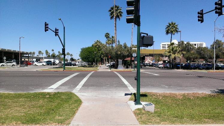
35 Transportation Group Pedestrian & Bicyclist Mobility Separated sidewalks and protected bike lanes promote multimodal usage Vegetation reduces asphalt cover and improves microclimate for pedestrians/bicyclists Hibbert Road Current Configuration Spring 2015 CEE/SOS/PUP 598 April 28 Mitigating Heat Vulnerability in Mesa, Arizona Slide 35

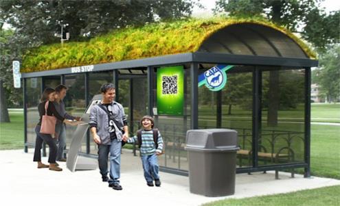
36 Transportation Group Transit Neighborhood circulator route Mobility without personal vehicle Also serves as mobile cooling environment Spring 2015 CEE/SOS/PUP 598 April 28 Mitigating Heat Vulnerability in Mesa, Arizona Slide 36
37 Transportation Group Heat Vulnerability and Exposure Assessing Walking Routes and Exposure Limits OSHA: Outside activity less than 15 minutes in heat General population needs more protection, 5 minutes Corresponding walking distance at 3 ½ feet per second is roughly 1,000 feet. People walk in cardinal directions, radial equivalent is 750 feet. Analyze map for appropriate coverage and locating heat refuges. Final design distance to be determined in collaboration with public health officials Spring 2015 CEE/SOS/PUP 598 April 28 Mitigating Heat Vulnerability in Mesa, Arizona Slide 37
38

39 Transportation Group Heat Vulnerability Locating Heat Shelters Consider Radial Travel Distances
40 Transportation Group Recommendations Reconfigure streets to promote walking and biking while reducing vulnerability to heat Increase the accessibility of the neighborhood by adding improved pedestrian access at Hibbert/University, First/Mesa, Pepper/Mesa Operate a neighborhood circulator bus route that connects the neighborhood to light rail while reducing walking/exposure durations Heat refuges to be placed at walking interval determined by coordination with public health officials Spring 2015 CEE/SOS/PUP 598 April 28 Mitigating Heat Vulnerability in Mesa, Arizona Slide 40

41 Landscaping, Shading, and Exterior Environments


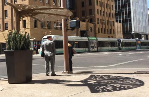
42 Shading Spring 2015 CEE/SOS/PUP 598 April 28 Mitigating Heat Vulnerability in Mesa, Arizona Slide 42


43 Shading Case Area s Pedestrian Corridor Spring 2015 CEE/SOS/PUP 598 April 28 Mitigating Heat Vulnerability in Mesa, Arizona Slide 43


44 Surfaces Sidewalks: Rubbersidewalks Maintenance requirements are significantly less in terms of life cycle costs than concrete. Rubber is 10 times less thermally conductive than concrete resulting in less heat release. Benefits of rubber in pedestrian corridors (5.5 mi): Labor Costs: $8 per sq ft for Concrete => 2.11 million dollars $1.5 per sq ft for Rubber => 396 thousand dollars Using Fourier s Law: Thermal Conductivity of Concrete 1.5 Thermal Conductivity of Rubber 0.15 Absorbed heat for pedestrian corridor (5.5 miles): Concrete: ~40,000 Watts/Kelvin Rubber: ~4,000 Watts/Kelvin Spring 2015 CEE/SOS/PUP 598 April 28 Mitigating Heat Vulnerability in Mesa, Arizona Slide 44


45 Surfaces Parking Lots: Consolidated parking structures or permeable surface lots. Convert to green space Spring 2015 CEE/SOS/PUP 598 April 28 Mitigating Heat Vulnerability in Mesa, Arizona Slide 45


46 Improvements to existing infrastructure Expand existing incentives: Xeriscaping low water use vegetation 500 sq ft - 1,250+ sq ft $ $3000 Reflective coatings Green walls Encouragement permitting, mailings, event flyers, public classes, etc. Spring 2015 CEE/SOS/PUP 598 April 28 Mitigating Heat Vulnerability in Mesa, Arizona Slide 46


47 Stormwater Capture Spring 2015 CEE/SOS/PUP 598 April 28 Mitigating Heat Vulnerability in Mesa, Arizona Slide 47


48 Pedestrian Corridors & Heat Refuges Pedestrian Corridor placement and implementation would be prioritized into 3 Phases with Heat Refuges positioned in strategic locations to support pedestrian travel. Spring 2015 CEE/SOS/PUP 598 April 28 Mitigating Heat Vulnerability in Mesa, Arizona Slide 48

49 Spring 2015 CEE/SOS/PUP 598 April 28 Mitigating Heat Vulnerability in Mesa, Arizona Slide 49

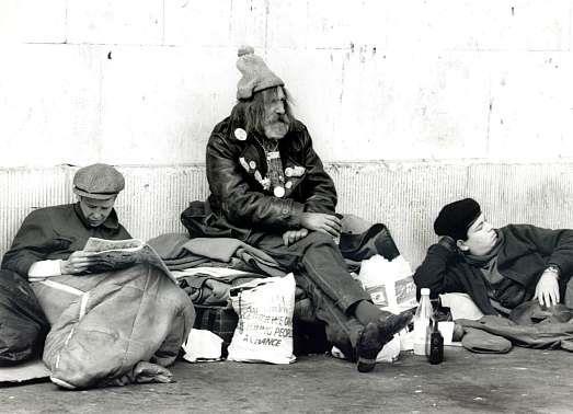


50 Determining vulnerability to heat Social and Institutional Considerations
51 Mitigation Plan Goal: Reduce social vulnerability to heat in Mesa Expand local incentives and programs Seek external resources, funding, partnerships Identify locations of vulnerability Establish cooling centers & hydration stations Internal and institutional support Spring 2015 CEE/SOS/PUP 598 April 28 Mitigating Heat Vulnerability in Mesa, Arizona Slide 51

52 Local Incentives and Programs Green Building Programs Scottsdale and Chandler City, commercial, and residential buildings International Green Construction Code (IcGG) Heat Island Mitigation Worksheet Expedited priority plan review Xeriscaping Incentives Glendale - up to $750 to convert 500 sq. ft. of turf to low water use landscape Scottsdale - up to $1,500 for turf removal at residential properties - up to $3,000 for commercial properties Peoria - up to $1,650 to convert 500 sq. ft. of turf to low water use landscape Public Communication & Education Scottsdale: Green Buildings Lecture Series Spring 2015 CEE/SOS/PUP 598 April 28 Mitigating Heat Vulnerability in Mesa, Arizona Slide 52
53 Institutional Support Federal Funding EPA Sustainable Skylines (Dallas, TX; Kansas, KS; Philadelphia, PA) Federal General Services Administration Green Roof (Florence, SC) Department of Energy Trees for Energy Saving (Denver, CO) Partnerships local municipalities, private and non-profit Local Energy Suppliers Trees for Tucson tree subsidies (Tucson Electric Power, Trico Electric coop, Kinder Morgan; Tucson, AZ) Reflective roof rebates (Austin Energy, -Austin, TX; Cool Houston! - Houston, TX) Local non profits Urban Forestry Program (Groundwork Elizabeth, Elizabeth, NJ) Gilbert, AZ currently seeking partnerships with other municipalities Spring 2015 CEE/SOS/PUP 598 April 28 Mitigating Heat Vulnerability in Mesa, Arizona Slide 53
54 Institutional Support New building and development guidelines Green building codes for city and commercial buildings Requirements of cool roofs, shade and/or vegetative cover Community outreach and involvement Educational meetings and workshops Adopt-a-Median tree planting program (Dallas, TX) Development of heat island and cool community task forces (Atlanta, GA; Philadelphia, PA, Austin, TX, others) Spring 2015 CEE/SOS/PUP 598 April 28 Mitigating Heat Vulnerability in Mesa, Arizona Slide 54

55 Public Survey Goal: Assess socio-technical vulnerabilities at household level Identify vulnerable social groups Income levels Housing styles Ethnicity Neighborhood Health Evaluate technology & services Building use Hours of operation Transportation Marketing Services offered Spring 2015 CEE/SOS/PUP 598 April 28 Mitigating Heat Vulnerability in Mesa, Arizona Slide 55
 Limited Services Conduct personal")

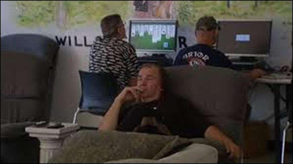
56 Cooling Centers & Hydration Stations Cooling Centers Access Issues Proximity Availability 50% on Saturday and Sunday Building Use Religious (13%) Limited Services Conduct personal business Community engagement Water distribution Access Issues Proximity Seasonal Waste produced Spring 2015 CEE/SOS/PUP 598 April 28 Mitigating Heat Vulnerability in Mesa, Arizona Slide 56


57 Improvements Spring 2015 CEE/SOS/PUP 598 April 28 Mitigating Heat Vulnerability in Mesa, Arizona Slide 57


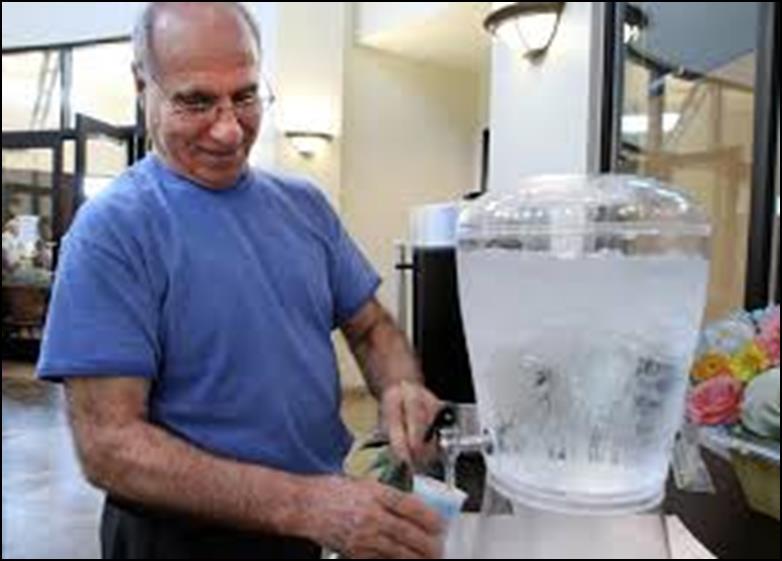
58 Hydration Stations Goal: Increase accessibility to water, improve water distribution Solutions Water bottle filling stations Commercially endorsed water bottles Benefits Quick, easy access Reusable reduce waste Reduce distribution issues New image for old fountains Continue to promote Mesa Hydration Donation Campaign Spring 2015 CEE/SOS/PUP 598 April 28 Mitigating Heat Vulnerability in Mesa, Arizona Slide 58


59 Heat Risk Education & Communication Education Efforts Symptoms of heat illness Maximum safe exposure time When to seek medical help General safety tips Communicate Available Resources Hydration and water bottle refill stations Cooling center locations Emergency information Communication Methods Broadcast media Voluntary Emergency Message System Post information MesaAZ.gov website Spring 2015 CEE/SOS/PUP 598 April 28 Mitigating Heat Vulnerability in Mesa, Arizona Slide 59

60 Heat Vulnerability Council Goal: Manage Heat Vulnerability Mitigation Plan & support program success Small team comprising of City of Mesa officials Community stakeholders Concerned citizen volunteers Successful Examples Philadelphia Heat Task Force El Paso s Heat Task Force Roles and Duties Review EHE best practices Update Heat Vulnerability Mitigation Plan Evaluate measures of success Spring 2015 CEE/SOS/PUP 598 April 28 Mitigating Heat Vulnerability in Mesa, Arizona Slide 60
61 Measures of Success Goal: Develop measures to evaluate the effectiveness of efforts to reduce social heat vulnerability in Mesa, Arizona Measures of Effectiveness # of heat-related hospitalizations (morbidity) # of heat-related deaths (mortality) Heat related emergency costs Ratio of person/sq. ft. area of accessible air conditioning # of persons utilizing cooling centers and hydration stations Spring 2015 CEE/SOS/PUP 598 April 28 Mitigating Heat Vulnerability in Mesa, Arizona Slide 61
62 Overview of Recommendations TRANSPORTATION Roadway Improvements Expand transit services New paving materials Multimodal services NEIGHBORHOODS & BUILDINGS Cool roofs Energy Production Heat Reduction Solar Light Tubes ENVIRONMENT Shading Tree Shading Improved Surfaces Stormwater infrastructure Improvement SOCIAL & INSTITUTIONAL Education Heat Vulnerability Adaptation Plan Measures of Effectiveness Heat Vulnerability Council Facades Spring 2015 CEE/SOS/PUP 598 April 28 Mitigating Heat Vulnerability in Mesa, Arizona Slide 62
Transportation Land Use Integration & Regional Planning. Don Kostelec, AICP Senior Planner, Louis Berger Group February 1, 2010
 Transportation Land Use Integration & Regional Planning Don Kostelec, AICP Senior Planner, Louis Berger Group February 1, 2010 Transportation Land Use Integration DOT-HUD-EPA Sustainable Communities Initiative
TRANSPORTATION ELEMENT GOALS, OBJECTIVES, AND POLICIES
 TRANSPORTATION ELEMENT GOALS, OBJECTIVES, AND POLICIES GOAL 2 The City shall provide a safe, convenient, effective, and energy efficient multimodal transportation system which is coordinated with the Future
Subregion 4 Central Avenue-Metro Blue Line Corridor Transit-Oriented Development (TOD) Implementation Project. Community Meeting April 27, 2011
 Implementation Project. Community Meeting April 27, 2011") Subregion 4 Central Avenue-Metro Blue Line Corridor Transit-Oriented Development (TOD) Implementation Project Community Meeting April 27, 2011 Overview Introduction to Subregion 4 TOD Implementation Program
Subregion 4 Central Avenue-Metro Blue Line Corridor Transit-Oriented Development (TOD) Implementation Project Community Meeting April 27, 2011 Overview Introduction to Subregion 4 TOD Implementation Program
CHAPTER 7: Transportation, Mobility and Circulation
 AGLE AREA COMMUNITY Plan CHAPTER 7 CHAPTER 7: Transportation, Mobility and Circulation Transportation, Mobility and Circulation The purpose of the Transportation, Mobility and Circulation Chapter is to
Dallas Urban Heat Island Options W AYS TO E FFECTIVELY R EDUCE U RBAN H EAT I SLAND E FFECTS 2009
 Dallas Urban Heat Island Options 1 W AYS TO E FFECTIVELY R EDUCE U RBAN H EAT I SLAND E FFECTS 2009 Background Dallas, like most cities, is hotter than comparable rural areas an urban heat island. 2 Urban
RIVER ARTS DISTRICT TRANSPORTATION PROJECT
 RIVER ARTS DISTRICT TRANSPORTATION PROJECT A section of the Public Meeting #3 December 6, 2012 The RiverWay Plan The Wilma Dykeman RiverWay is a 17 mile corridor along the French Broad and Swannanoa Rivers.
Sustainably Repositioning Greyfield Sites. Greyfield Sites Anywhere
 Sustainably Repositioning Greyfield Sites Jim Constantine Looney Ricks Kiss Architects Todd Poole 4ward Planning Greyfield Sites Anywhere Pennsylvania Chapter American Planning Association Conference 2009
Ann Arbor Downtown Street Design Manual. Ann Arbor DDA IDA 2015 Awards Planning Category
 Ann Arbor Downtown Street Design Manual Ann Arbor DDA IDA 2015 Awards Planning Category 1 Ann Arbor s downtown streets are vibrant public spaces that accommodate multi-modal transportation, special events,
Por favor, levanten la mano si necesita traduccion en espanol Please raise your hand if you need Spanish translation
 FEDERAL BOULEVARD CORRIDOR WIDE STUDY PUBLIC MEETING #1 APRIL 27, 2016 Por favor, levanten la mano si necesita traduccion en espanol Please raise your hand if you need Spanish translation HDR DESIGN WORKSHOP
Plano Tomorrow Vision and Policies
 Plano Tomorrow Vision and Policies PLANO TOMORROW PILLARS The Built Environment The Social Environment The Natural Environment The Economic Environment Land Use and Urban Design Transportation Housing
Making Transit Oriented Development Work For Boonton, NJ
 Making Transit Oriented Development Work For Boonton, NJ Bloustein School of Planning and Public Policy Studio Dan Burton Loannie Dao Webster Slater Brandon Williams Ian Watson Maria Laham Nicola Mammes
Town Center (part of the Comprehensive Plan)
") Town Center (part of the Comprehensive Plan) Mercer Island Town Center Looking North (2014) In 1994, a year-long process culminated in a set of design guidelines and code requirements for the Town Center
Town Center (part of the Comprehensive Plan) Mercer Island Town Center Looking North (2014) In 1994, a year-long process culminated in a set of design guidelines and code requirements for the Town Center
1 Adapted from the Statewide Transit-Oriented Development Study by CalTrans, 2006
 APPENDIX C: LAND USE PLANNING FOR ENHANCED RAIL SERVICE 72 BACKGROUND One of the consistent themes heard from localities in the Route 29 corridor Planning Forums was the need for expanding rail service
Rezoning Issues Setting a Foundation for Zoning Decisions
 Rezoning Issues Setting a Foundation for Zoning Decisions City Council Workshop May 2, 2016 Agenda Goal Need actionable items and sequence of steps Foundation for Zoning Decisions Council Workshop Discussion
Study Area. Capitol Way. Greening America s Capitals 11/13/2014. A Greening America s Capitals Project
 Olympia, WA: Greening Capitol Way Supporting Communities move towards sustainability is a priority for the federal government. A Greening America s Capitals Project Office of Sustainable Communities U.S.
JANUARY 19, 2011 CENTRAL AVENUE-METRO BLUE LINE TRANSIT-ORIENTED DEVELOPMENT IMPLEMENTATION PROJECT COMMUNITY FORUM
 CENTRAL AVENUE-METRO BLUE LINE TRANSIT-ORIENTED DEVELOPMENT IMPLEMENTATION PROJECT COMMUNITY FORUM JANUARY 19, 2011 THE MARYLAND-NATIONAL CAPITAL PARK AND PLANNING COMMISSION PRINCE GEORGE S COUNTY PLANNING
TRANSIT-ORIENTED DEVELOPMENT POLICY DRAFT. City Planning and Development Department Kansas City, Missouri
 TRANSIT-ORIENTED DEVELOPMENT POLICY DRAFT City Planning and Development Department Kansas City, Missouri What is Transit Oriented Development (TOD)? Development that focuses land uses around a transit
Toronto Complete Streets Guidelines
 Toronto Complete Streets Guidelines 108 110 7.1 Green Infrastructure Design Principles 112 7.2 Context-Sensitive Green Streets 114 7.3 Key Green Street Elements Green infrastructure refers to natural and
TOD 101 CREATING LIVABLE COMMUNITIES WITH TRANSIT
 1 CREATING LIVABLE COMMUNITIES WITH TRANSIT What are transit Centered Communities? Benefits of Partnerships to Support and Implement What You Will Learn Portland s Pearl District Your Trainers Today Catherine
City of Bristol Route 6 Corridor Implementation Program
 City of Bristol Route 6 Corridor Implementation Program FITZGERALD & HALLIDAY, INC. Innovative Planning, Better Communities June 2017 Route 6 Corridor Plan IMPLEMENTATION PROGRAM The following Implementation
Executive Summary. NY 7 / NY 2 Corridor
 Executive Summary NY 7 / NY 2 Corridor Transportation and Land Use Study December 2005 Prepared for: Town of Colonie Capital District Transportation Committee Prepared by: Introduction: Land use decisions
A BLUEPRINT FOR BROCKTON A CITY-WIDE COMPREHENSIVE PLAN
 A BLUEPRINT FOR BROCKTON A CITY-WIDE COMPREHENSIVE PLAN Public Meeting October 2016 1 Plan Summary and Discussion Public Meeting May 4 2017 City of Brockton Bill Carpenter, Mayor Department of Planning
Shift Rapid Transit Public Participation Meeting May 3, 2017
 Shift Rapid Transit Public Participation Meeting May 3, 2017 Shift Rapid Transit Initiative Largest infrastructure project in the city s history. Rapid Transit initiative will transform London s public
IMPLEMENTING SOMERSET COUNTY S INVESTMENT FRAMEWORK
 IMPLEMENTING SOMERSET COUNTY S INVESTMENT FRAMEWORK SMART CONSERVATION THROUGH SMART GROWTH NJ LAND CONSERVATION RALLY March 22, 2014 Laurette Kratina, PP, AICP, Supervising Planner Somerset County Planning
TRANSIT ORIENTED DEVELOPMENT PINELLAS COUNTY MPO LIVABLE COMMUNITIES INITIATIVE PINELLAS COUNTY COMPREHENSIVE PLAN AMENDMENTS
 PINELLAS COUNTY MPO LIVABLE COMMUNITIES INITIATIVE MODEL LAND DEVELOPMENT CODE TRANSIT ORIENTED DEVELOPMENT PINELLAS COUNTY COMPREHENSIVE PLAN AMENDMENTS MPO Livable Communities Initiative Goal: Improve
City of Hermosa Beach Administrative Policy #
 City of Hermosa Beach Administrative Policy # SUBJECT: Living Streets Policy Date: Approved by: City Council Authority: Public Works Department & Community Development Department Mayor, PURPOSE The City
Implementation Guide Comprehensive Plan City of Allen
 Implementation Guide 2030 Comprehensive Plan City of Allen DRAFT 2015 Implementation Guide Allen 2030 Comprehensive Plan INTRODUCTION The Comprehensive Plan serves as a guide for the growth and development
Denver Moves: Transit Task Force
 Insert transit picture Denver Moves: Transit Task Force Meeting #8 October 5, 2017 1. Welcome & Introductions Opening remarks and housekeeping Task Force and audience introductions Upcoming events and
Town of Oakville Streetscape Strategy
 Town of Oakville Streetscape Strategy Endorsed by PDC on February 10, 2014 (PD-011-14) Town of Oakville Streetscape Strategy [endorsed by PDC February 10, 2014] 0 Town of Oakville Streetscape Strategy
Blueprint Denver Task Force Meeting #
 Blueprint Denver Task Force Meeting #1 6.23.16 1. Welcome and Introductions Your name and affiliation Name 1 thing you love about Denver Name 1 thing you d change about Denver All in 30 seconds! Ready,
GREENING THE BOULEVARD Master Plan Concepts for Venice Boulevard between Lincoln and Sawtelle
 GREENING THE BOULEVARD Katherine Spitz Associates Inc. 4212½ Glencoe Avenue Marina Del Rey, CA 90292 310 574 4460 Fax 574 4462 January 2008 Table of Contents Overview Proposed Design Improvements Illustration
Dogpatch/22nd Street Greening
 TEAM MEMBERS Prepared for: GreenTrustSF Central Waterfront www.gtsfcw.org Prepared by: Fletcher Studio San Francisco, CA www.fletcherstudio.com Landscape Architecture Urban Design Environmental Planning
Historic Preservation Preserve, restore or adaptively re-use historic structures and landscapes.
 Checklist for New Construction Developers of building projects in the Loring Park Neighborhood are encouraged to pursue the standards that are identified below. For large projects requiring special allowances,
CHAPTER 7: VISION AND ACTION STATEMENTS. Noble 2025 Vision Statement
 CHAPTER 7: VISION AND ACTION STATEMENTS This chapter presents the vision, policy and action statements that transform the comprehensive planning study, an analysis of Noble s past, future trends and community
Silverdale Regional Center
 Silverdale Regional Center Vision for Silverdale Regional Center The Silverdale Regional Center Plan (Plan) will guide the evolution of the Silverdale Regional Center from a collection of strip malls and
Sustainable Infrastructure and South Mountain Village: Land Use and Transit Oriented Development
 Sustainable Infrastructure and South Mountain Village: Land Use and Transit Oriented Development COURSE PROJECT PRESENTATION 23 April 2018 Tari Alford Hanan Alhashmi Aric Burks Matt Gomez Matthew Waldman
SDOT DPD. SDOT Director s Rule DPD Director s Rule DCLU DR SED DR of 7 CITY OF SEATTLE
 SDOT SDOT Director s Rule 2-07 DPD Applicant: CITY OF SEATTLE Page 1 of 7 Supersedes: DCLU DR 11-93 SED DR 93-4 Seattle Department of Transportation (SDOT) Department of Planning and Development (DPD)
Bethesda Downtown Plan
 Bethesda Downtown Plan Planning Board Update Connecticut Avenue Location Economic Sustainability Social Environmental Scope Coming Soon! Team Listening, Twitter Outreach We Are Here Engagement Challenge
Long Branch Sector Plan
 June 2012 Long Branch is one of Montgomery County s most affordable, older communities and has served as a gateway community, especially for newly arriving immigrants, since the 1960s. Many within this
treet Alley 23rd Street FOR SALE 2419 and Street, PRIME CENTRAL CORE OPPORTUNITY Sacramento, CA 95815
 FOR SALE 2419 and 2421 23 Street, Street McCulley Brothers Complete Automotive Repair Google rdmaps 95815 plete Automotive Repair PRIME CENTRAL CORE OPPORTUNITY X Street Broadway S treet ing nald s pa
For More Information
 C O R P O R A T I O N THE ARTS CHILD POLICY CIVIL JUSTICE EDUCATION ENERGY AND ENVIRONMENT This PDF document was made available from www.rand.org as a public service of the RAND Corporation. Jump down
Horizon 2035 Land Use and Transportation Element
 CITY OF SUNNYVALE Horizon 2035 Land Use and Transportation Element City Council Study Session March 7, 2017 Overview General Plan Context Mixed Use Villages Transportation Mode & Parking General Plan Policy
University of the District of Columbia Van Ness Campus Master Plan Community Open House 3. December 8, 2010
 University of the District of Columbia Van Ness Campus Master Plan Open House 3 December 8, 2010 Introductions Sequence of Work: Campus Master Plan BEGIN: INTRODUCE AND START WORK Project Initiation Team
Route 1 Corridor Study
 Route 1 Corridor Study Westbrook, Connecticut A Vision for the Connecticut Shoreline Public Informational Meeting July 28, 2015 Lower Connecticut River Valley Council of Governments Fitzgerald & Halliday,
COMPLETE GREEN STREET CHECKLIST
 COMPLETE GREEN STREET CHECKLIST This document was developed to dissect the structure of an urban street and explore opportunities to make our streets more complete while also integrating green street strategies.
DRAFT FOR PUBLIC REVIEW. Game Plan for a Healthy City
 DRAFT FOR PUBLIC REVIEW 2018 Game Plan for a Healthy City 2 Denveright. Parks & Recreation Game Plan Draft for Public Review Draft for Public Review Executive Summary Game Plan Overview Executive Summary
Smart Growth for Dallas
 Smart Growth for Dallas Data-driven decisions for the future of Dallas parks, open spaces, and green infrastructure Dallas Park and Recreation Board March 10, 2016 Agenda I. Welcome and Introductions II.
Recommendations and Best Practices: City of Goodyear Demonstration Garden
 Recommendations and Best Practices: City of Goodyear Demonstration Garden Kayce Flowers Andy Stein December 2014 1 1 Table of Contents 1 Introduction... 3 2 Background and purpose... 3 3 Methods... 4 4
4.1.3 LAND USE CATEGORIES
 4.1.3 LAND USE CATEGORIES a. City Center District The City Center District incorporates the existing character and mix of uses in downtown Belmont to encourage redevelopment and new development in keeping
ITEM #8. Regional Smart Growth Program. Regional Smart Growth Program. Presentation Overview. Coast Highway Vision and Stategic Plan.
 Regional Smart Growth Program Economic Development Commission What is Smart Growth? Adopted as part of the Regional Comprehensive Plan (RCP) RCP provides vision for region based on Smart Growth and sustainability
Streets for People, Place-Making and Prosperity. #TOcompletestreets
 COMPLETE STREETS FOR TORONTO Streets for People, Place-Making and Prosperity COMPLETE STREETS: A NEW APPROACH A Complete Streets design approach considers the needs of all users people who walk, bicycle,
EXISTING COMPREHENSIVE PLAN
 EXISTING COMPREHENSIVE PLAN Town Center Land Use Element: V. LAND USE POLICIES Town Center Mercer Island's business district vision as described in "Your Mercer Island Citizen-Designed Downtown" was an
Urban Design Manual PLANNING AROUND RAPID TRANSIT STATIONS (PARTS) Introduction. Station Study Areas
 Introduction. Station Study Areas") 111111 PLANNING AROUND RAPID TRANSIT STATIONS (PARTS) Introduction The ION rapid transit system will link Waterloo, Kitchener and Cambridge through a central transit corridor (CTC). There are a number
111111 PLANNING AROUND RAPID TRANSIT STATIONS (PARTS) Introduction The ION rapid transit system will link Waterloo, Kitchener and Cambridge through a central transit corridor (CTC). There are a number
MAIN STREET ECONOMIC DEVELOPMENT STRATEGY
 MAIN STREET ECONOMIC DEVELOPMENT STRATEGY A PATHWAY TO A BETTER POUGHKEEPSIE DRAFT Working Paper #2: Planning Strategies Submitted December 1 st, 2015 to the City of Poughkeepsie LAND USE LAW CENTER PACE
SW Ecodistrict A VISION PLAN FOR A MORE SUSTAINABLE FUTURE June 25, 2013
 Urban Land Institute The Past, Present and Future of Sustainable Urbanism in Southwest DC SW Ecodistrict A VISION PLAN FOR A MORE SUSTAINABLE FUTURE June 25, 2013 Study Area The National Mall DOE FAA FAA
40 Years of Smart Growth Arlington County s Experience with Transit Oriented Development in the Rosslyn-Ballston Metro Corridor
 40 Years of Smart Growth Arlington County s Experience with Transit Oriented Development in the Rosslyn-Ballston Metro Corridor A presentation by the Arlington County Department of Community Planning,
SPRINGHILL LAKE TRANSIT VILLAGE
 Greenbelt Metro Area Sector Plan - Subarea Design Policies and Guidelines - Springhill Lake Transit Village 113 SPRINGHILL LAKE TRANSIT VILLAGE Residential Neighborhood and Village Center CONCEPT Springhill
Street Flooding Mitigation Plan KYOVA Interstate Planning Commission. Presented to AMPO National Conference October 18, 2017
 Street Flooding Mitigation Plan KYOVA Interstate Planning Commission Presented to AMPO National Conference October 18, 2017 Saleem Salameh, Ph.D., P.E., M.ASCE Chet Parsons, AICP CTP Agenda: Background
Public input has been an important part of the plan development process.
 Lakewood s Comprehensive Plan recognizes that transportation helps shape the community, and that the way the community provides for the safe and efficient movement of people affects the character of the
FDOT D4 Complete Streets
 FDOT D4 Complete Streets Context Sensitive Solutions Directs that complete street solutions will complement the context of the community. Collaborative approach to decision making, project development,
8implementation. strategies
 PROGRAM STRATEGIES 8implementation strategies T he implementation actions of this chapter are designed to support and carry out the land use, economic development, transportation, urban design, and program
The Auburn Plan Designing the Future of Auburn February 28, 2005
 The Auburn Plan Designing the Future of Auburn February 28, 2005 Block-by-Block Bicycle Tour Aerial survey Focus Group Meetings September 7 and 8 Design Workshops October 11, 14, and 21 Revitalization
7Page 91 CLEMMONS COMMUNITY COMPASS 7 COMMUNITY CHARACTER
 7 Community Character The beauty of Clemmons won t necessarily be a reflection of our past, but our future. This quote from Comprehensive Plan Steering Committee member Wayne Dodson captures the essence
FUNDING CORRIDOR REVITALIZATION
 FUNDING CORRIDOR REVITALIZATION Integrated corridor planning for the 21 st Century America Planning Association Annual Conference Atlanta, GA April 27, 2014 Mariia Zimmerman, MZ Strategies, LLC mariia@mzstrategies.com
Lesson 6. Corridor Planning
 Lesson 6 Corridor Planning 1 Learning Outcomes Identify land use strategies and solutions that can be incorporated into multimodal transportation corridor plans Identify land use stakeholders and describe
Welcome. Comprehensive Plan & Transportation Plan Open House November 7, 2012
 Welcome Comprehensive Plan & Transportation Plan Open House November 7, 2012 Agenda Proposed future land use plan Comprehensive Plan strategies Traffic forecasts Future traffic operations Possible future
1.0 VISION STATEMENT. December 6, PRINCIPLES
 Vision Statement Lincoln Regional Airport 1.0 VISION STATEMENT 1.1 City LOCATION of AND OVERVIEW The Easton Lincoln Place Land Use Master Plan identifies the principles, goals, policies, and standards
Mini Technical Assistance Panel. Rock Spring Park
 Mini Technical Assistance Panel Rock Spring Park May 22, 2013 The Team Jason Bonnet, Forest City Washington Matthew Flis, Town of Vienna William Herbig, National Capital Planning Commission Sophie Lambert,
CITY OF CLEVELAND GREEN DESIGN GUIDELINES
 CITY OF CLEVELAND GREEN DESIGN GUIDELINES SEPTEMBER 18, 2008 PROJECT COMPLIANCE PATH: 1. Approved master plan 2. Approved design district boundaries 3. Approved district design guidelines, Green design
Welcome to the Oakridge Centre Open House
 Welcome to the Oakridge Centre Open House Why is the City hosting this event? This open house is to inform you of a rezoning application submitted to the City of Vancouver to amend the existing CD-1 (Comprehensive
REGIONAL ACTIVITY CENTER
 DRAFT REGIONAL ACTIVITY CENTER 70 EAST BENCH MASTER PLAN DRAFT 06 Introduction The East Bench Regional Activity center is comprised of large educational, research, medical, and employment centers. These
Scope of Services. River Oaks Boulevard (SH 183) Corridor Master Plan
 Corridor Master Plan") Scope of Services River Oaks Boulevard (SH 183) Corridor Master Plan PROJECT AREA The project area consists of the River Oaks Boulevard (SH 183) corridor bounded by SH 199 at the northern end and the Trinity
Scope of Services River Oaks Boulevard (SH 183) Corridor Master Plan PROJECT AREA The project area consists of the River Oaks Boulevard (SH 183) corridor bounded by SH 199 at the northern end and the Trinity
Windsor Locks Transit-Oriented Development Planning Grant Request. Project Background
 Windsor Locks Transit-Oriented Development Planning Grant Request Project Background Downtown Windsor Locks runs along Main Street in the vicinity of the intersection of Routes 159 and 140. The current
implementation r expression in landscape
 6 ubc okanagan implementation campus plan r expression in landscape 68 6 implementation campus plan sections The Campus Plan supports the academic mission, values and commitments of the University by providing
CHAPTER 8 ISSUES, CONCERNS, CONSTRAINTS AND OPPORTUNITIES
 CHAPTER 8 ISSUES, CONCERNS, CONSTRAINTS AND OPPORTUNITIES Introduction This River Conservation Plan was developed during a time of tremendous activity and effort in planning the transformation of the Delaware
Chapter 1: Introduction
 Chapter 1: Introduction The Penn Avenue Community Works Corridor Vision and Implementation Framework presents an integrated communitybased vision and a coordinated, long-term implementation framework for
I. DESCRIPTION OF PROPOSED ACTION... 1 A. General Description... 1 B. Historical Resume and Project Status... 2 C. Cost Estimates...
 PROJECT COMMITMENTS SUMMARY... S-1 1. Type of Action... S-1 2. Description of Action... S-1 3. Summary of Purpose and Need... S-1 4. Alternatives Considered... S-2 5. NCDOT Alternatives Carried Forward...
Kelowna Sustainability Checklist
 Kelowna Sustainability Checklist The City of Kelowna endeavours to Sustain the Environment. Encourage development and land use changes that will not compromise the ability of future generations to meet
Policies and Code Intent Sections Related to Town Center
 Policies and Code Intent Sections Related to Town Center The Town Center Vision is scattered throughout the Comprehensive Plan, development code and the 1994 Town Center Plan. What follows are sections
Transportation. Strategies for Action
 Transportation A major priority for the Overlake Neighborhood is to develop a multimodal transportation system. To achieve this system, a balance has to be found among travel, circulation and access needs;
The West Vaughan Employment Area Secondary Plan Policies
 Part 2: The West Vaughan Employment Area Secondary Plan Policies 2.1 General Policies It is the policy of Council: 2.1.1. That the West Vaughan Employment Area (the WVEA), identified on Schedule 1, will
Potential Green Infrastructure Strategies May 6, 2015 Workshop
 Potential Green Infrastructure Strategies May 6, 2015 Workshop Background The City of Cortland is developing the Tioughnioga Urban Headwaters Green Infrastructure Action Plan with funding from the National
C. Westerly Creek Village & The Montview Corridor
 C. Westerly Creek Village & The VISION Community Vision When the goals of the city are achieved Westerly Creek Village, a distinctive community defined by Montview Boulevard and Westerly Creek, is a strong
Cobb County Design Guidelines Mableton Parkway & Veterans Memorial Highway Community Design Workshop January 12, 2017
 Community Design Workshop January 12, 2017 Agenda Opening Remarks / Introductions Scope of Work Existing Conditions Key Issues / Opportunities VPS Summary Draft Vision & Goal Statement Implementation Concepts
Courthouse Square Planning & Urban Design Study. Courthouse Square Working Group #13 October 15, 2014
 Courthouse Square Planning & Urban Design Study Courthouse Square Working Group #13 October 15, 2014 1 Courthouse Square Process Working Group Community Courthouse Square Advisory Groups & Civic Associations
EXHIBIT A. Tax Increment Reinvestment Zone No. 1 (Town Center) First Amended Project Plan 1
 First Amended Project Plan 1") EXHIBIT A Tax Increment Reinvestment Zone No. 1 (Town Center) First Amended Project Plan 1 1 As amended by Resolution No. 2008-02-001(TR1R) of the Tax Increment Reinvestment Zone No.1, and approved to
EXHIBIT A Tax Increment Reinvestment Zone No. 1 (Town Center) First Amended Project Plan 1 1 As amended by Resolution No. 2008-02-001(TR1R) of the Tax Increment Reinvestment Zone No.1, and approved to
RESIDENTIAL DISTRICTS
 RESIDENTIAL DISTRICTS The residential district standards have been revised to reflect on-the-ground conditions, while continuing to respect the use patterns established within the neighborhoods. This will
Tyvola & Archdale Transit Station Area Plan. June 5, 2008
 Tyvola & Archdale Transit Station Area Plan Second Public Meeting June 5, 2008 Presentation Outline 1. Purpose and Process 2. Station Area Overview 3. Plan Recommendations 4. Comments Received and Proposed
FROM DUPONT CIRCLE NORTH TO CALIFORNIA STREET, NW. Welcome!
 FROM DUPONT CIRCLE NORTH TO CALIFORNIA STREET, NW Welcome! Meeting Agenda 6:00 PM Open House 6:30 PM Presentation 7:00 PM Open House / Q&A at the Boards Project Design Team Connecticut Avenue, NW Project
The Teacher is In! School Siting Tools You Can Use
 The Teacher is In! School Siting Tools You Can Use New Partners for Smart Growth Conference January 30, 2015 Regina Langton Senior Policy Analyst EPA Office of Sustainable Communities 1300 Constitution
12/9/2013. HOLLYWOOD/PINES CORRIDOR PROJECT AMPO 2013 Annual Conference October 24, Our Perspective. Broward.
 HOLLYWOOD/PINES CORRIDOR PROJECT AMPO 2013 Annual Conference October 24, 2013 Our Perspective Broward Fort Lauderdale 1 Broward Metropolitan Planning Organization Fort Lauderdale Fort Lauderdale Skyline
The transportation system in a community is an
 7 TRANSPORTATION The transportation system in a community is an important factor contributing to the quality of life of the residents. Without a sound transportation system to bring both goods and patrons
International Blvd. TOD Plan Public Workshop #1
 International Blvd. TOD Plan Public Workshop #1 Add photos or project images September 21 and 22, 2010 Workshop Purpose Introduce the public to the Project Review and discuss the existing conditions analysis
Integrated Urban Development. April Reflections from the NZPI Study Tour of Portland, Seattle and Vancouver
 Integrated Urban Development April 2009 Reflections from the NZPI Study Tour of Portland, Seattle and Vancouver Integrated Urban Development Urban Growth Management Transportation Transit Orientated Mixed
Today Land & People. Northeast Nampa Gateway District. Employment. Land Use Characteristics. Demographics. Current Zoning
 Today Land & People Employment Major employers include Saint Alphonsus, the College of Western Idaho, the Auto Mall, Sorrento Lactalis and Walmart. 3,004 jobs in 2010 (COMPASS-CIM 2040 TAZ data) 4,345
BAGBY STREET RECONSTRUCTION PROJECT OCTOBER 2, 2015
 BAGBY STREET RECONSTRUCTION PROJECT OCTOBER 2, 2015 CLAIRE HEMPEL, PLA, AICP, LEED GA PREPARED BY Aspen Asheville Austin Chicago Denver Dubai Houston Lake Tahoe Los Angeles MIDTOWN : A MODEL OF URBAN DEVELOPMENT
2035 General Plan Update and Belmont Village Specific Plan. Joint Study Session with the City Council and Planning Commission April 12, 2016
 2035 General Plan Update and Belmont Village Specific Plan Joint Study with the City Council and Planning Commission April 12, 2016 Agenda 1. Welcome and Introductions 2. General Plan Update Status of
SAN RAFAEL GENERAL PLAN 2040 INTRODUCTION AND OVERVIEW
 SAN RAFAEL GENERAL PLAN 2040 INTRODUCTION AND OVERVIEW Steering Committee Presentation February 14, 2018 Purpose of General Plan Guide land use and development decisions Coordinate transportation, infrastructure,
CHAPTER 8. Mrs. Zimman s Class - Central Elementary
 SUSTAINABILITY CHAPTER 8 Mrs. Zimman s Class - Central Elementary 8.1 OVERVIEW Green infrastructure also known as low impact development (LID) and environmental or sustainable site design is an environmentally
From Partnership to Reality
 From Partnership to Reality New Partners for Smart Growth February 4, 2011 What is Sustainable (human) Development? It is development that meets the needs of the present without compromising the ability