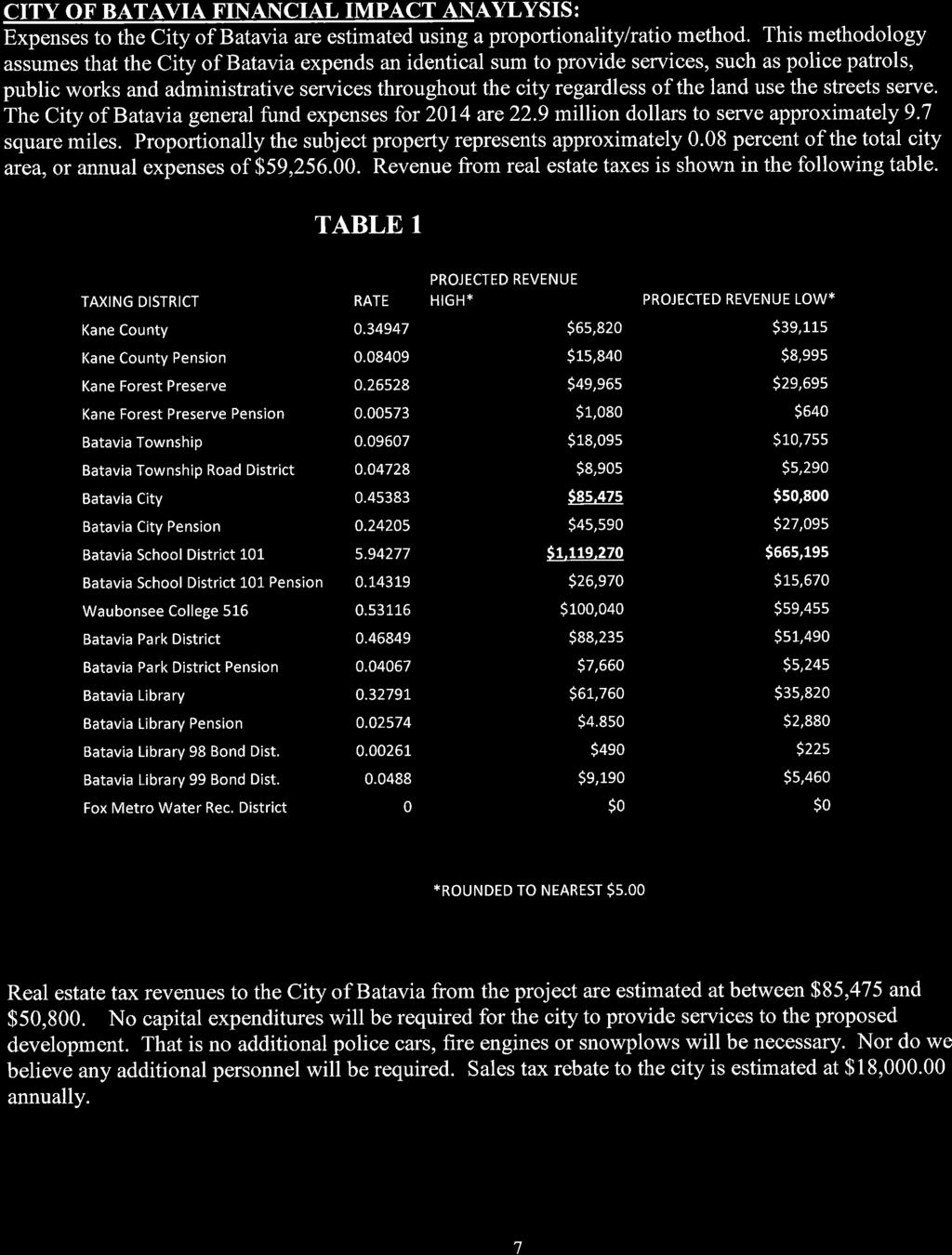
CITY OF BATAVIA. DATE: March 28, 2014 TO: FROM: Plan Commission Joel Strassman, Planning and Zoning Officer
|
|
|
- Arline Cameron Carter
- 5 years ago
- Views:
Transcription
1 DATE: March 28, 2014 TO: FROM: Plan Commission Joel Strassman, Planning and Zoning Officer CITY OF BATAVIA SUBJECT: PUBLIC HEARING: Amendments to the Comprehensive Plan Land Use (continued from 3/26) Map and Official Zoning Map Southeast Corner of Kirk Rd. and Wind Energy Pass The Missner Group, applicant Summary of Applications and Public Hearing On March 19th, the Plan Commission opened and continued to March 26 a public hearing to consider amendments to the City of Batavia Comprehensive Plan Land Use Map and official Zoning Map. For complete information on this proposal please see the documents linked to this proposal and meeting minutes via the City of Batavia website s Plan Commission agendas at March 19 agenda, March 26 agenda, and April 9 agenda. On March 26, the Plan Commission heard additional testimony from the applicant clarifying numbers in the traffic report, describing industrial space availability in the area, and providing insight on a financial analysis submitted by one of the objectors at the previous meeting. Chris Tiedeman of Land Partners, explained that he has been marketing the property for approximately 2 years. In that time he has received no serious interest from any buyer for any use except for The Missner Group s proposal. Mr. Missner submitted several documents (attached) including a copy of an expired boundary agreement with the City of Aurora that specified industrial use of property in this vicinity. The public hearing continued with 20 speakers addressing the Commission, including 3 that had spoken at the last meeting. Of the new speakers, 3 were neutral in their comments, 9 were opposed to the proposal, and 5 were in favor of the proposal. Neutral speakers included statements that balanced the benefits to the community at large with negative impacts to the immediate area. New opposition comments questioned what effect a change to land use on the subject property would have on the land use classifications for the other unincorporated properties to the north and northwest. Speakers in favor of the proposal reiterated positive economic effects including increased potential for heavy electric users. Several additional documents were submitted, including a petition of opposition from the Kirkland Chase Townhome residents. All submitted documents are attached. After closing the hearing, the Commission requested staff provide a review of how each goal and policy of the Comprehensive Plan responds to the proposed Land Use Plan Map amendment. The Commission then continued this proposal to its meeting on April 9 when they would discuss it. Attached is the Comprehensive Plan goal and policy review requested by the Commission; staff review of each goal and policy appears in red. Staff Recommendation Staff recommends the Commission discuss the merits of the proposal. The Commission may ask questions of the staff, applicant, or public hearing speakers. As a reminder, there are no required findings to recommend approval of the Land Use Map amendment. The only findings required for an amendment to the Zoning Map are that: 1. the hearing was noticed and held in accordance with the Zoning Code, and 2. the amendment conforms to the goals and policies of the Comprehensive Plan and conforms to the Land Use Map (either as existing or concurrently proposed to be amended). Staff affirms that hearing was noticed and conducted as required by the Zoning Code. Staff continues to recommend approval of the requested map amendments as stated in the March 21 memorandum to the Commission. Attachments 1. Comprehensive Plan goal and policy review 2. Applicant and hearing attendee information submitted at the hearing c Mayor and City Council Department Heads Media
2 Review of Comprehensive Goals and for Missner Proposal Land Use Element Goal 1. Maintain Batavia as an attractive place to live, work, shop and play, with a balance of land uses Existing and proposed land use provide potential to create jobs, and places to play and shop. Existing land use provides potential for residences a. Designate enough industrial land to provide opportunities for job creation, and protect it from conversion to non-employment use Proposed land use would provide additional industrial land to meet market need. b. Protect key retail properties from conversion to non-retail uses while allowing multitenant properties to house a healthy mix of uses Subject property has not been identified as a key retail property; if so identified, the proposal largely would not protect its conversion. c. Encourage mixed uses of land where they are compatible and integrated with the neighborhood Industrial use abutting residential is common in Batavia, but is not ideal. The uses may be compatible through proper site planning. d. Raise the quality of new development through zoning, subdivision, design review and other tools Not applicable to this proposal e. Proactively and fairly enforce land use regulations Not applicable to this proposal Goal 2. Protect and enhance environmentally sensitive and historically significant places City, State, and Federal regulations ensure protection with any development scenario. Further protection could be enforced through the annexation agreement. a. Designate and adopt historic districts to protect historic neighborhood character Not applicable to this proposal. b. Seek landmark designation for key historic properties Not applicable to this proposal c. Use floodplain management, wetland protection, tree preservation, conservation management and similar tools to protect significant environmental resources See response to Goal 2. d. Expand the open space network to link major park, forest preserve and wetland areas with each other and similar resources in adjacent jurisdictions Site planning will require open space connections. Goal 3. Plan land uses to achieve an efficient provision of public facilities and services Development under existing and proposed land use will be well served by public facilities a. Focus higher density and intensity development in and adjacent to the downtown Existing entitlements would focus higher density development away from the downtown. 1
3 b. Coordinate land use decisions with the availability of public facilities and services, especially schools and sanitary sewers See response to Goal 3. c. Avoid underdevelopment of property with ample utility capacity, especially in the downtown Not applicable to this proposal d. Reserve adequate sewer capacity for downtown development, annexation of unincorporated island properties and key infill parcels Not applicable to this proposal site is served by Fox Metro. Goal 4. Maintain a diversity of housing types, prices and styles for all segments of the community Proposed land use does not reduce existing housing stock but does eliminate potential for additional housing a. Encourage use of the Zoning Code Planned Development Overlay Zoning District residential density bonus to insure affordability Proposed land use eliminates potential for additional housing. b. Encourage new, and the expansion of existing senior housing complexes Proposed land use eliminates potential for this type of housing. c. Provide a mixture of housing types and densities on large scale mixed use redevelopment parcels See response to Policy b. d. Effectively use information from studies of the Batavia housing market to better address City-wide housing needs Proposed land use eliminates potential for all types of housing at this location. Goal 5. Coordinate land use and transportation planning Development of any type of use will require road improvements coordinated with KDOT a. Carefully manage entrances and exits to public streets, in concert with Kane County and IDOT, to insure safe and convenient access to property See response to Goal 5. b. Locate higher density residential uses convenient to transit corridors and employment centers Subject property is not located on an existing transit corridor. c. Provide internal circulation routes within and between developments to avoid forcing traffic onto collector and arterial streets Site planning will require such routes. d. Include bicycle and pedestrian circulation systems in new and expanded developments Site planning will require such systems. Goal 6. Continue to make the downtown and the Fox River the focal point of the community Proposed land use has greater potential to retain downtown as a retail focal point a. Focus the most intense development in the downtown Proposed land use will reduce retail development competition with downtown. b. Improve pedestrian accessibility and safety throughout the downtown Not applicable to this proposal 2
4 c. Use redevelopment tools, including tax increment financing, to encourage and shape downtown development Not applicable to this proposal d. Require development projects to take advantage of views and access to the Fox River Not applicable to this proposal e. Make Fox River frontage accessible to the public by bicycle trails, parks, plazas and pedestrian areas Not applicable to this proposal f. Insure safe, convenient, and inviting pedestrian access into the downtown from surrounding neighborhoods Not applicable to this proposal g. Locate significant new public community facilities in the downtown Not applicable to this proposal h. Invest in community amenities and public art to make the downtown attractive and inviting Not applicable to this proposal Goal 7. Redevelop obsolete industrial areas as mixed-use developments compatible with neighborhood character Goal and policies are not applicable to this proposal subject property is not a redevelopment site a. Plan for adaptive reuse and redevelopment of older industrial areas b. Provide incentives for creative mixed-use redevelopment of abandoned industrial areas c. Integrate viable historic structures into new developments d. Continue and extend the existing street pattern in redevelopment projects e. Provide community gathering spaces in major redevelopment projects Goal 8. Provide gradual land use transitions and buffers between lower intensity and higher intensity uses Proposed land use would not provide gradual land use transitions. Site development will require buffers with any type of development a. Transition from industrial uses to service business or office uses adjacent to residential neighborhoods Proposed land use would not provide such transition. b. Where appropriate, encourage new developments to provide larger than required setbacks and additional screening as a transition between incompatible uses Such setbacks will be required through the annexation agreement. c. Transition land uses within large-scale new developments Such transitions will be required through the annexation agreement. d. Use streets, rail lines and natural features instead of property lines as land use district boundaries Development will use such features where existing. Subject property is located adjacent to existing development where introduction of such features would be inappropriate. e. Consider transitional zoning district designations to effectively separate incompatible land uses when amending the Official Zoning Map See response to Policy a. 3
5 Transportation and Circulation Element Goal 1. Maintain and enhance a cohesive, interconnected transportation network, giving opportunities for multiple routes of travel Site planning will require transportation network maintenance and enhancement a. Connect developments to the existing transportation infrastructure, continuing and connecting streets See response to Goal 1. b. Promote walking and cycling as alternatives to automobile travel by providing sidewalk and multi-use trail connections to transit, when available, in new development and redevelopment See response to Goal 1. c. Avoid one-way traffic circulation on downtown streets Not applicable to this proposal d. Work with other transportation partners to insure that the implementation of improvement projects complement and expand transportation networks Development for any use requires working with KDOT. e. Interconnect traffic signals in the City to improve traffic flow KDOT controls signals and interconnection of signals on Kirk. f. Encourage connectivity of new and existing neighborhoods by interconnecting sidewalks and multi-use trails Site Planning will require connectivity to existing sidewalks and trails. Goal 2. Relieve traffic pressure on the downtown river crossing Goals and are not applicable to this proposal a. Make land use decisions that can synergize with a future Fox River bridge at the determined location b. Continue to explore funding opportunities to improve the Prairie and Wilson Street intersection to a signalized intersection c. Refine downtown traffic flows without a redesign of Route 25 Goal 3. Provide safe and attractive routes of travel for pedestrians and bicyclists Intersection improvements will be required by KDOT. Development will require such routes on the property. a. Create a pedestrian friendly downtown, using standardized design elements that enhance the pedestrian environment Not applicable to this proposal b. Introduce pedestrian countdown signals at all signalized intersections, downtown intersections being the first priority Intersection improvements will be required by KDOT. c. Require sidewalks in all new development and redevelopment of properties Sidewalks will be required. d. Continue implementation and enhancement of the City sidewalk program, with the immediate goal of interconnecting public places and parks with sidewalks, and an 4
6 ultimate goal of having sidewalks on both sides of all streets Interconnections and sidewalks will be required. e. Create a continuous Fox River Bicycle Trail through the planning area Not applicable to this proposal f. Develop an interconnected network of bicycle routes to enhance bicycle transportation throughout the community Site development review will require new routes and connection to existing routes. g. Provide amenities and accommodations for bicyclists and pedestrians in future improvements and developments/redevelopments, such as bike racks and weatherprotected parking, benches, and waste and recycling containers Such facilities are required by the Zoning Code. h. Provide pedestrian scale lighting along pedestrian and bicycle routes in the downtown Not applicable to this proposal Goal 4. Develop and support local and regional mass transit options in the planning area Site development may assist in providing these options in the future a. Enhance transit stops to better identify their locations and to provide amenities such as shelters and transit system information Annexation agreement can require this when needed. b. Promote mass transit opportunities that connect Batavia with the greater Chicago region Not applicable to this proposal c. Improve transit stops to ensure access by bicyclists, pedestrians and persons with disabilities Annexation agreement can require this when needed. Goal 5. Determine future projects and funding mechanisms Goal and are not applicable to this proposal this refers to City projects a. Continue development and use of a Capital Improvement Program outlining future projects b. Work with regional, State and Federal partners to provide funding for transportation enhancement projects c. Seek grant opportunities for funding of transportation projects Goal 6. Ensure that land use and transportation decisions are compatible Transportation improvements will be required with any development a. Support the integration of transportation and land use planning by the City, County and regional planning partners City has sought input from outside agencies b. Ensure that both land use and transportation issues are considered concurrently for all projects See response to Goal 6. c. Increase residential density in the downtown to promote pedestrian travel, thereby reducing the use of automobiles Not applicable to this proposal 5
7 d. Promote bicycle trails as an economic asset to the downtown area Not applicable to this proposal Goal 7. Ensure that the community is accessible to persons of all levels of mobility This will be required through site planning and for a and b. a. Ensure that persons with disabilities are provided with equal access to homes, employment areas, shopping, recreational areas and other community destinations Site planning and building permit review will require compliance with Illinois Americans with Disabilities Act b. Provide opportunities for transportation assistance to the non-driving public Not applicable to this proposal c. Ensure that all public facilities meet State and Federal accessibility codes Not applicable to this proposal. Goal 8. Manage parking to meet land use, economic development and urban design goals Adequate parking will be required of any development a. Encourage shared parking arrangements in the downtown to better accommodate parking demands, including the siting of additional structures in each quadrant Not applicable to this proposal b. Sign parking areas in a consistent and easy to read manner This will be required. c. Develop a wayfinding sign program for the downtown to assist pedestrians and motorists in finding places of interest and parking Not applicable to this proposal d. Screen off-street parking areas from view from streets and residential areas This will be required as part of Site Planning review. Goal 9. Enhance railroad crossing safety for pedestrians and bicyclists Goal and are not applicable to this proposal a. Redesign bicycle crossings at railroad tracks b. Provide fully accessible, clearly delineated, and properly identified pedestrian routes at railroad crossings c. Coordinate traffic control improvements at the Prairie and Wilson intersection to improve travel and reduce accidents Goal 10. Manage downtown and neighborhood traffic Effects to neighboring areas will be considered with any development proposal a. Develop truck routes to channel industrial traffic away from the Wilson Street bridge Not applicable to this proposal 6
8 b. Increase traffic enforcement activity in neighborhoods, as needed Any development has potential to increase traffic. Enforcement will be increased if warranted. c. Implement traffic calming measures, such as textured or raised crosswalks, pedestrian islands and bump-outs to slow traffic in selected locations If applicable, this will be coordinated with KDOT. d. Consider the use of roundabouts in place of controlled intersections where feasible to enhance traffic flows Not applicable to this proposal Public Facilities and Services Element Goal 1. Provide quality municipal services in a cost-effective manner City will do so with any development a. Maintain a multi-year capital improvement plan for all City infrastructure and major capital purchases Proposed land use has potential to allow land uses that require less infrastructure. b. Coordinate utility and street improvements to avoid damage to new pavement See response to Policy a. c. Continually explore methods for cost savings in City facilities See response to Policy a. d. Evaluate partnerships with public and private organizations as a mechanism for lowering the cost of public facilities Not applicable to this proposal e. Coordinate capital projects with other governmental agencies, utility companies and private developers Any development will require such coordination. f. Provide a higher level of street and sidewalk maintenance in the downtown Not applicable to this proposal g. Investigate cost sharing in the provision of some City services Can be explored in an amended annexation agreement. h. Evaluate the feasibility of implementing a stormwater utility to provide facilities to alleviate flooding and drainage problems See response to Policy g. Goal 2. Consider services provided by other agencies in City decision-making Batavia has informed other jurisdictions of the proposed map amendment and public hearing a. Evaluate student population impacts in new residential developments There would be no such impacts as proposed. b. Use Fox Metro Water Reclamation District for sanitary sewer service where feasible Property is in their sanitary district and they have been informed of proposed map amendment. c. Use state and regional purchasing agreements for equipment and facilities where cost and time savings can be achieved Not applicable to this proposal d. Coordinate street maintenance and plowing with Townships, Kane County and IDOT This policy would continue regardless of this development proposal. 7
9 e. Study the use of intergovernmental agreements for sharing of facilities and services with other agencies Batavia has informed other jurisdictions of the proposed map amendment and will participate in cost sharing if appropriate. Goal 3. Have new development pay its own way Any new development will include infrastructure improvements to be built by the developer a. Require full cost recovery for the extension of City utilities to new development Developer will be responsible for utility extensions consistent with the City Code and annexation agreement. b. Periodically update impact fees to insure that future capital improvements are fully funded Fees will be specified in an amended annexation agreement. c. Recover the cost of development processing and approval through fees for services Can be considered through annexation agreement. d. Consider establishing buy-in fees for annexation of territory to the City Such fees can be considered through the annexation agreement. Goal 4. Provide reliable and high quality emergency response services Number of City emergency response events have potential to be reduced with development under proposed land use compared to existing entitlements. a. Respond to emergency police calls in 5 minutes or less See Goal 4 response. b. Respond to 90% of emergency fire suppression calls with an engine company within 4 minutes of a 911 call and supplement response with full resources within 8 minutes See Goal 4 response. c. Respond to 90% of Emergency Medical Service (EMS) calls with arrival of a first responder within 4 minutes of a 911 call, and arrival of an Advanced Life Support unit (ALS) within 8 minutes See Goal 4 response. d. Construct a second bridge crossing of the Fox River in the downtown to provide a second or alternate emergency access Not applicable to this proposal e. Insure adequate fire hydrant placement throughout the community in accordance with national standards Will be required. f. Prepare emergency operations plans for each jurisdiction and utility, routinely train personnel in their roles and coordinate emergency plans with other jurisdictions and utilities Not applicable to this proposal g. Maintain current system security plans for all utilities and facilities Any development will ensure safety of such facilities. Goal 5. Coordinate City service provision with private utilities and other governmental jurisdictions Batavia has informed other jurisdictions of the proposed map amendment a. Continue to participate in the Tri-Com emergency dispatch system Not applicable to this proposal 8
10 b. Coordinate electric power distribution with ComEd Not applicable to this proposal c. Connect potable water systems to those of adjacent municipalities to insure uninterrupted service Not applicable to this proposal d. Continue membership in the Northern Illinois Municipal Power Agency (NIMPA) Not applicable to this proposal e. Continue cooperation with AT&T for completion of their digital communication infrastructure Will be considered with site development. f. Expand the City's fiber optic network to improve communications service to businesses and public agencies See response to Policy e. Goal 6. Establish reasonable boundaries for the extension of City services, including aligning City boundaries with other service providers Goals and are not applicable to this proposal a. Set an ultimate sanitary sewer service area based on treatment plant capacity b. Provide City utility service outside the City limits only when issues of public health exist and only if a pre-annexation agreement is signed c. In areas where pockets of unincorporated property exists, require property annexations to reduce or eliminate such pockets to achieve orderly City boundaries d. Provide direct City public safety services to non-residents only for emergencies, and insure that all costs are recovered Goal 7. Use utility capacity strategically for City development and redevelopment Proposed land use can allow development to better use City utilities a. Allocate adequate sanitary sewer capacity for downtown redevelopment projects Not applicable to this proposal b. Retain sewer capacity for infill projects when extending service for annexations Not applicable to this proposal c. Where feasible use Fox Metro to provide sanitary sewer service Property is in their sanitary district. d. Allow emergency sewer connection to homes in unincorporated areas with failing septic systems only with concurrent annexation, or require the property owner sign an agreement to annex to the City when it is possible to do so Not applicable to this proposal Goal 8. Use private contractors to provide services to City residents when it is costeffective to do so, and when service levels can be maintained Not applicable to this proposal a. Provide weekly residential solid waste and recyclable material collection services using competitively bid private vendors; consider expanding recycling to business and multifamily uses b. Continue to evaluate the privatization of services, including contracting for specialized or short-term needs 9
11 c. Use private consultants for engineering design work and planning studies that are onetime projects and those that require specialized expertise Goal 9. Insure a reliable supply of electricity for Batavia residents and businesses at costs below those of private utility providers The proposed land use provides entitlements for large electric users to operate on the property; that can help lower electrical usage costs to all customers. a. Invest in system upgrades to insure an highly reliable power supply and a redundant distribution system Not applicable to this proposal b. Continue to evaluate energy portfolio to maintain the best mix of sources and appropriate levels of contracted energy to maintain affordable rates Not applicable to this proposal Goal 10. Continually search for ways to improve the quality and reliability of services to the community Goals and are not applicable to this proposal a. Participate in regional and state professional organizations b. Adopt best practices in service delivery, adapted to local conditions c. Provide incentives for more effective and efficient service delivery d. Conduct regular security evaluations of public facilities and implement priority recommendations Economic Development & Redevelopment Element Goal 1. Facilitate open communication between the City and existing and prospective businesses Goal would be unaffected by any development scenario. a. Maintain an effective business retention and expansion program Not applicable to this proposal b. Explore benefits and drawbacks of business registration or licensing Not applicable to this proposal c. Actively participate in activities of the Chamber of Commerce, Batavia MainStreet and other business organizations and encourage reciprocal participation in City activities Not applicable to this proposal d. Implement a marketing program to attract businesses that fulfill market needs Such a program customized for this property may be required through the annexation agreement. e. Encourage business owners to partner with the City to explore programs and policies that balance increased commerce with protection of property values and neighborhood character City will require development and on-going business practices to protect adjacent properties through the annexation agreement. 10
12 Goal 2. Employ traffic and parking management techniques to best serve business and resident interests City will work with developer and businesses as well as with KDOT. a. Encourage expanded use of public transportation systems Such systems are not proximate. b. Support roadway improvements that facilitate commerce Any development will require roadway improvements. c. Encourage the use of parking management plans in downtown Not applicable to this proposal Goal 3. Improve the quality of land development to make Batavia an attractive place for new investment Development possible under proposed land use requires an amended annexation agreement. Land development quality in excess of standard City Code requirements will be required through the annexation agreement. a. Maintain up to date development guidelines Not applicable to this proposal b. Promote quality exterior lighting designs that balance effectiveness with sustainable practices Will be required through annexation agreement c. Insure that new developments acknowledge the importance of pedestrians and bicyclists Will be required through annexation agreement d. Incorporate public art in larger developments May be required through annexation agreement e. Preserve significant historic buildings and features Not applicable to this proposal f. Require all development to employ best management practices for protection and preservation of environmental resources See response to Policy b g. Be sensitive to regulations and their effect to the cost of land development Aspects of development will be negotiated through the annexation agreement. Goal 4. Increase employment and housing opportunities suited to a variety of life situations and income levels Proposed amendment has potential to provide such employment opportunities. Existing land designations have potential to provide such housing and employment opportunities. a. Use annexation and development/redevelopment agreements effectively to ensure an appropriate mix of commercial uses and housing types An amended annexation agreement, possible only with the proposal can be used for this purpose. b. Participate in targeted marketing for commercial and industrial uses This may be required through an amended annexation agreement. c. Focus economic development efforts on increasing jobs that pay above average wages Proposed land use provides greater potential for such jobs. Goal 5. Form effective partnerships with the private sector to stimulate redevelopment Goal and are not applicable this is not a redevelopment site 11
13 a. Use City-sponsored programs to accomplish redevelopment goals b. Search for alternative project financing opportunities c. Encourage local businesses to bid on projects d. Establish clear and efficient development review processes e. Use public funding to offset development costs of public improvements f. Engage real estate professionals with proven success in redevelopment Goal 6. Ensure that redevelopment strengthens downtown Batavia as the center of the community Goal and are not applicable to this proposal a. Promote uses and activities that reinforce downtown as the civic and cultural heart of the community b. Make the downtown a desired destination to live, work and play Goal 7. Continue to improve utility infrastructure to accommodate the needs of all businesses This is possible under any land use classification. a. Facilitate upgrades to telecommunication systems such as wireless internet, fiber optics, etc Will be required where appropriate. b. Seek ways to increase reliability and efficiency of City-owned utility distribution and supply while decreasing costs Proposed land use classification allows for uses that can increase such efficiency and decrease costs. c. Strive to exceed environmental standards on infrastructure projects Can be accomplished through the annexation agreement. Goal 8. Increase customer and visitor activity Existing land use has greater potential to allow uses that generate customer and visitor activity. a. Promote the city as an attractive destination for commerce and recreation through a variety of media Not applicable to this proposal. b. Collaborate with other public and private organizations to increase awareness of City resources and amenities to enhance marketing efforts Outside organizations are aware of this proposal and may participate in such efforts. Environment Element Goal 1. Protect and enhance the City s and the region s air, land and water resources Existing and proposed land use classifications have potential to allow uses and development that can enhance or harm such resources. Existing land use has potential to allow development that would not increase pollution associated with diesel-powered vehicles operating on the property. Site development under the proposed land use allows for site improvements exceeding the City Code to enhance land and water resources. 12
14 a. Encourage the preservation and enhancement of valuable natural resources in their current form as an alternative to mitigating development impacts This can be required (as opposed to simply encouraged) through the annexation agreement. b. Encourage downtown redevelopment that provides environmentally sensitive public access to the Fox River Not applicable to this property c. Encourage the use of native plants and landscape materials in all development d. Preserve groundwater recharge areas and drainage and wildlife corridors This can be required through the annexation agreement. e. Minimize erosion, stormwater runoff and pollution by requiring the use of best management practices, including limits on pesticide use, for all construction activities especially adjacent to wetlands This will be required of any development. f. Encourage other agencies, such as the Forest Preserve and Park Districts to acquire, develop, and expand accessible natural areas, such as Tanglewood Hills Park Park District land and facilities are and will be required through the annexation agreement. g. Reduce impervious surfaces through the use of permeable pavers and similar techniques, to promote the recharge of local aquifers and to provide natural pre-treatment of stormwater runoff This can be required through the annexation agreement. Goal 2. Be a leader in environmental issues and act as an example for others Batavia can do this and all policies below through implementation of existing codes and through the annexation agreement a. Incorporate environmental considerations into decision-making processes See Goal 2 response. b. Allow innovative development design, such as conservation development, to protect natural resources See Goal 2 response. c. Continue to support and promote the clean-up and redevelopment of contaminated and environmentally sensitive areas See Goal 2 response. d. Ensure a gradual transition from the natural to the man-made environment See Goal 2 response. e. Invest in and use clean energy sources whenever possible See Goal 2 response. f. Support worthwhile programs initiated by other agencies to address local, national, and global environmental health See Goal 2 response. g. Where practical, adopt reasonable and effective regulation of noise and odor generation. See Goal 2 response. Goal 3. Encourage the responsible use of environmental resources and energy See Goal 2 response. a. Encourage sustainable building practices in construction activities See Goal 2 response. b. Promote water and energy conservation through public outreach and information programs Not applicable to this proposal. 13
15 c. Establish energy audit and retrofit programs for older homes and commercial structures Not applicable to this proposal. d. Educate residents, businesses, and visitors to increase awareness of environmental issues and programs Not applicable to this proposal. e. Promote a walkable community by encouraging mixed use, infill and compact development patterns that reduce walking distances See Goal 2 response. f. Promote a walkable and bikeable community as envisioned in the Batavia Bicycle Plan, incorporating multi-use trails and bike routes into new development See Goal 2 response. g. Promote the use of public transportation by supporting upgrades to the PACE bus system, including sidewalk and bicycle path connections to new bus shelters Annexation agreement can require this when needed. h. Reduce the amount of material entering the municipal waste stream through environmentally responsible purchasing policies and expanded recycling programs Annexation agreement can require such a program. Parks and Open Space Element Goal 1. Provide an abundant supply of parks and open spaces Development under existing entitlements or under the proposed land use categories will require public park facilities and/or spaces. a. Periodically review the City Code to ensure that the land-cash donation requirement in the Subdivision Regulations remains at the maximum legal level Not applicable to this proposal. b. Periodically review the Zoning Code to ensure that it mandates significant quantities of useable private open space Not applicable to this proposal. c. Involve the Geneva and Batavia park districts and the Kane and DuPage County forest preserve districts in annexation and development proposals, especially where a land-cash donation applies City has involved the park district in this proposal. d. Support park and forest preserve districts in their efforts to acquire and develop parks and open spaces and indoor recreation facilities. See response to Policy c. e. Connect parks and open spaces with trails that also access existing and future public transportation facilities See response to Policy c. f. Preserve or reclaim property adjacent to waterways for open space use and to help improve the quality of water that enters the waterways preserve and enhance naturalized settings Not applicable to this proposal. Goal 2. Balance active and passive open spaces Any development will require public park facilities and/or spaces, allowing for balanced space usage. a. Support park districts' efforts to gather input from area residents on desired park and open space facilities City has involved the park district in this proposal. b. Apply effective development standards to provide reasonable transitions from active and passive use parks and open spaces to differing land uses, especially residential This will be done through implementation of existing codes and through the annexation agreement 14
16 c. Support creation of specialized parks and open spaces when the need for each is established Any development will require public park facilities and/or spaces. d. Allow for the evolution of recreation areas and facilities to accommodate new equipment and infrastructure to meet use demands City has involved the park district in this proposal and it can request, and the City can require such accommodation. e. Develop fully accessible active and passive recreation facilities that can accommodate persons of all levels of abilities See response to Policy d. f. Combine both active and passive use areas on the same property See response to Policy d. g. Retain or reestablish natural areas The effective annexation agreement accommodated existing areas; an amended annexation agreement needed to fulfill the applicant s land use map change request can reestablishment of such areas. h. Encourage opportunities for a variety of open space uses in the planning areas. This can be required (as opposed to just encouraged) through an amended annexation agreement. Goal 3. Strengthen the Fox River corridor as the prominent open space amenity in the Batavia planning area Goal and are not applicable to the proposal. a. Seize opportunities to increase public access to the Fox River b. Provide for bike and multi-use trail links to have direct access to the Fox River c. Actively participate in efforts to create corridors of open spaces along the Fox River s banks, including the acquisition of river-adjacent properties d. Take a leadership role in creating and establishing programs to protect water and land quality in and adjacent to the river e. Seek ways to increase active recreational use of the Fox River f. Consider proposed developments environmental health impacts to the Fox River and its riparian areas, as well as their effects on views to and from the river g. Encourage park districts and the Forest Preserve District to maintain their properties adjacent to the Fox River in a manner that protects the health of the river and supports public access to the river Goal 4. Maintain and enhance existing park and open space facilities Goals and are not applicable to the proposal there are no existing park or open space facilities. a. Ensure that adequate financial resources are available to properly care for City owned open spaces b. Consider development of Open Space only if abundant open space would remain and development furthers other goals of the Comprehensive Plan c. Protect and enhance views of open spaces d. Monitor and participate in planning and development activities undertaken by adjacent jurisdictions to protect open spaces in the Batavia Planning Area e. Require environmentally sensitive open spaces on commonly-owned private property to be protected with a conservation easement and have ample funding for professional management 15
17 f. Encourage the establishment of conservation easements on, or professional management of, environmentally sensitive areas on individually-owned private properties g. Support Batavia Park District in their efforts to preserve the Harold Hall Quarry Beach to insure it continues its historic recreation role Goal 5. Require open spaces as part of development approvals for all significant residential and non-residential projects This will be required of any development under existing entitlements or proposed land use categories a. Apply development regulations to provide the required amount of useable open space and encourage the provision of additional open space Requirements in excess of the minimum may be required through an amended annexation agreement. b. Encourage stormwater management areas to be designed with native vegetation and to accommodate active and/or passive recreational use This may be required through an amended annexation agreement. c. Emphasize the benefits of conservation easements for, and professional management of, environmentally sensitive open spaces on private property and require these when reasonable and possible See response to Policy d. d. Require new development to construct bicycle and multi-use trails as shown in the Batavia Bicycle Plan This will be required of any development. Housing, Neighborhood Conservation and Historic Preservation Element Goal 1. Provide a wide range of housing opportunities for people in all life circumstances The proposed land use will eliminate opportunities for housing opportunities a. Provide a diversity of quality rental and owner occupied housing The proposed land use classification will eliminate this opportunity. b. Seek appropriate housing developments in anticipation of increased senior population The existing property entitlements do not require such housing. The proposed land use classification will eliminate this opportunity. c. Provide community workforce housing The existing property entitlements do not address housing affordability. The proposed land use classification will eliminate this opportunity. d. Continue to allow accessory units such as granny flats, in-law arrangements and coach homes where appropriate The existing property entitlements do not allow such housing. The proposed land use classification will eliminate this opportunity. e. Seek opportunities to supply quality affordable housing The existing property entitlements do not address housing affordability. The proposed land use classification will eliminate this opportunity. f. Encourage varied housing styles, densities and types within neighborhoods The existing property entitlements do not address housing variety. The proposed land use classification will eliminate this opportunity. 16
18 g. Accommodate housing needs for persons with disabilities The existing property entitlements do not address housing accessibility. The proposed land use classification will eliminate this opportunity. h. Stress the importance to financial and lending institutions of remaining committed to meet all housing needs of the City Not applicable to this proposal. i. Maintain opportunities to provide higher density housing in conjunction with mixed-use developments Not applicable to this proposal. Existing entitlements and proposed land use classifications do not allow mixed use developments. j. Coordinate with faith-based community and social service providers to address the issue of homelessness in the community The existing property entitlements do not address this policy. The proposed land use classification will eliminate this opportunity. Goal 2. Preserve the character of established residential neighborhoods Proposed land use classifications allow for land uses that are less compatible than uses allowed with existing entitlements. Site planning opportunities through an annexation agreement under the proposed land use classifications can require extraordinary development features to provide buffering between uses. a. Strengthen and enforce property maintenance codes Not applicable to this proposal. b. Prevent commercial encroachment into residential neighborhoods Not applicable to this project there is no residential neighborhood on this property, therefore, no expansion into such neighborhood is proposed. c. Identify, improve and rehabilitate deteriorating residential properties Not applicable to this proposal. d. Ensure that rental housing meets Housing Quality Standards through a licensing and inspection program Not applicable to this proposal. e. Expand Crime Free Housing Program if pilot program is successful to all rental properties in the city Not applicable to this proposal. Goal 3. Conserve historical and cultural resources Goal and are not applicable to this proposal. a. Maintain an up-to-date historic preservation ordinance b. Support the Historic Preservation Commission in its efforts to identify, and to preserve historic resources in a flexible manner c. Continue and expand the Historic Preservation Commission s educational role on historic preservation to citizens and members of the community d. Develop a landmark survey to identify unique properties with historic, community, architectural, or aesthetic importance, interest, or value e. Keep an updated Historic Property Survey f. Support organizations that actively promote Batavia s cultural heritage and history g. Study the establishment of future historic districts 17
19 Goal 4. Create diverse neighborhoods Goal and are not applicable to this proposal. a. Maintain effective Multi-Family Design Guidelines b. Identify areas of infill development that do not disrupt the existing neighborhood environment c. Consider development and redevelopment at greater density where appropriate Goal 5. Improve neighborhood quality Development under existing entitlements and under the proposed land use categories has potential to negatively affect the quality of nearby neighborhoods. Any development will require quality site and building improvements; extraordinary quality can be mandated through an amended annexation agreement. a. Encourage all residents and property owners to become stakeholders in improving their neighborhoods While the City of Batavia has no cause to encourage this anywhere except the subject property with this proposal, the City has ensured that land entitlement review and decisions are and will be conducted in an open, transparent manner. b. Support efforts to increase neighborhood safety See response to Goal 5, Policy a. c. Continue City infrastructure improvements, especially those that promote pedestrian friendly and walkable neighborhoods This will be required of any development. Goal 6. Assure quality living environments The City s codes and opportunities through annexation agreements provide opportunities to require land development to buffer itself from adjacent land uses a. Require establishment of homeowners associations in new neighborhoods that contain commonly owned improvements City codes require commonly owned improvements to be properly maintained by an association. Entitlements on the subject property require establishment of a back-up special service area to ensure funding availability for maintenance with any development. b. Establish backup special service areas where homeowner associations maintain common facilities See response to Goal 6, Policy a. c. Maintain contemporary building and construction codes Not applicable to this proposal. d. Enforce all building, safety, zoning and fire codes to prevent overcrowding and unsafe conditions Not applicable to this proposal. e. Discourage the use of subdivision identification signs to promote a unified Batavia identity. Existing entitlements provide for such a sign. Through an amended annexation agreement required with this proposal, such a sign can be prohibited. 18
20 Urban Design Element Goal 1. Improve the quality of the built environment Development possible under both the existing and proposed land uses will be high quality through application of existing City codes and requirements of an amended annexation agreement. a. Through design review, implement established design criteria for all new and remodeled commercial, industrial, institutional and multi-family projects, including changes to parking lots This policy will be implemented with any development either as existing or proposed. b. Encourage high quality building materials and extensive landscaping in public and private projects See response to Policy a. c. Continue the commitment to quality design in City construction projects, and work with other public entities to reinforce that objective in their projects Not Applicable, as it refers to projects for City and other public agency facilities. d. Require all sides of a building or project to be of a consistent design quality when it will be visible from public streets, residential uses or areas accessible to the public Existing entitlements require this and extraordinary quality can be required through an amended annexation agreement. e. Insure that mechanical and electrical equipment is screened from public view Existing entitlements require this and extraordinary screening can be required through an amended annexation agreement. f. Reduce the scale of large retaining walls by terracing and landscaping See response to Policy a. g. Construct landscaped stormwater detention basins with natural contours and gradual side slopes See response to Policy a. Goal 2. Integrate the preservation of natural and historic features into new developments This can be accomplished with existing entitlements or as proposed a. Retain and reuse viable historic buildings and architectural elements as a part of redevelopment projects Not applicable to this proposal. b. Preserve wetlands, significant trees, watercourses and other important environmental features in new development projects when feasible; mitigate landscape removal when preservation is not possible See response to Goal 2. c. Preserve natural and historic site features to the maximum extent possible See response to Goal 2. Goal 3. Use landscaping to soften new development, screen unattractive elements, minimize heat gain, and to provide relief from urbanization This can be accomplished with existing entitlements or as proposed 19
21 a. Incorporate frequent large planters with deciduous trees in parking lots See response to Goal 3. b. Screen building- and ground-mounted mechanical and electrical equipment from public view using shrubs, trees, berms and/or screen walls Existing entitlements require this and extraordinary screening can be required through an amended annexation agreement. c. Screen parking lots from streets using either shrubs, low walls, berms or a combination of materials Existing entitlements require this and extraordinary screening can be required through an amended annexation agreement. d. Use large setbacks, evergreen trees, fences and shrubs to buffer residential uses from commercial and industrial uses Existing entitlements require this and extraordinary screening can be required through an amended annexation agreement. e. Landscape projects in a manner that enhances and complements their architecture See response to Policy a. f. Continue an active street tree planting and maintenance program Street trees will be required with any development. g. Landscape projects with a combination of evergreen and deciduous plant material Existing entitlements require this and extraordinary landscaping can be required through an amended annexation agreement. h. Use landscaping to establish a sequence of entry to sites and buildings To be addressed with design review. i. Include outdoor use spaces in new developments, including seating, tables, paths, vegetation, enhanced pavement, shade and trash receptacles Existing entitlements require this and extraordinary landscaping can be required through an amended annexation agreement. j. Screen downtown businesses existing trash/recycling receptacles from public view Not applicable to this proposal. Goal 4. Promote art in public places throughout the community Existing entitlements do not require this. This can be required through an amended annexation agreement possible with this proposal. a. Incorporate a requirement for public art into design guidelines for commercial, office and large-scale residential projects See response to Goal 4. b. Consider the establishment of a City arts commission to oversee and manage the City s art collection, advise the City Council on acquisitions, and to promote a wide range of performing and visual art exhibits in the community Not applicable to this proposal. c. Require that a percentage of the budget for new major City capital projects be devoted to permanent public art Not applicable to this proposal. d. Collaborate with arts organizations, individual artists, businesses, and other jurisdictions to advance the arts in Batavia Not applicable to this proposal. Goal 5. Insure that new development maintains a human scale Existing entitlements do not require this, but this may be achieved through application of City codes and discretionary procedures. This can be required through an amended annexation agreement possible only with this proposal. 20
22 a. Avoid using larger building masses when smaller, distinct building units and architectural enhancements can better provide a pedestrian focus See response to Goal 5. b. Use landscape islands and pedestrian walkways to divide large parking lots into smaller fields, and to make street crossings safer This will be required with any development. c. Avoid blank building walls facing publicly accessible areas See response to Goal 5. d. Encourage use of appropriately sized building materials such as brick, stone and block or modulating large expanses of exterior finish insulation systems (EIFS) to create visual interest See response to Goal 5. e. Reduce the scale of parking lot lighting, signage and structures in retail and office projects See response to Goal 5. f. Provide an inviting, human scale to public spaces by creating intimate seating areas, shade structures, water features, and other similar elements See response to Goal 5. g. Provide multiple, convenient pedestrian entrances to public places and encourage the same for retail buildings See response to Goal 5. h. De-emphasize or screen utilitarian aspects of projects, including gas pumps, service areas, loading docks and utility areas See response to Goal 5. i. Avoid visual clutter in retail development by limiting outdoor merchandise displays See response to Goal 5. j. Emphasize human scale entries for all buildings; use entrance canopies and awnings for shelter See response to Goal 5. Goal 6. Consider lighting as a design element in new public and private development projects This will be considered with any development. Also, see response to Goal 5. a. Protect residential areas and streets from light trespass and glare This would be sought with any development. As proposed, many fewer street lights would be required. b. Use lighting to accent architecture and improve streetscapes See response to Goal 6. c. Provide adequate lighting for safety and security, but avoid over-illumination This will be required with any development. d. Mount pole and building light fixtures as low as possible to achieve adequate lighting Existing entitlements do not require this. This can be required through an amended annexation agreement possible with this proposal. e. Permit creative and energy-efficient illumination sources that enhance signs and architecture, but which do not become a distraction to motorists See response to Goal 6. f. Encourage use of energy-efficient lighting See response to Goal 6. Goal 7. Make public and private signage an asset to the community See response to Goal 5 for this and for a-f, below. a. Insure that signs are legible and in scale with adjacent streets and structures. b. Use coordinated signage for shopping centers, office and industrial parks 21
23 c. Avoid sign clutter by careful design and spacing of freestanding and wall signs; encourage building designs that include a sign frieze d. Require signs to be built of high quality materials, be well maintained, and to be removed when no longer needed e. Allow some changeable-message signs, but carefully regulate the rate of change to avoid appearance of movement f. Coordinate the design of freestanding signs with the architecture of the buildings they identify g. In the Downtown Historic District and on landmarked properties ensure signage balances respect to the historic character of the buildings and neighborhood with use of modern materials that create interesting or unique designs to facilitate effective communication Not applicable to this proposal. h. Develop wayfinding signs for the downtown Not applicable to this proposal. Goal 8. Highlight significant gateways and important places in the City by community signage, public art and windmills See response to Goal 5 for this and for a-c, below. a. Install welcome signs at major entry points to the City b. Require major commercial projects to acquire, install and maintain an illuminated windmill or significant public art in a prominent location c. Incorporate a windmill or significant public art into the site design of major new City buildings d. Maintain unique identification signs for the Downtown Historic District and historically significant buildings Not applicable to this proposal. Goal 9. Improve the image of the City as viewed from public streets This will be sought with any development. Also, see response to Goal 5 for this and b-e and h, below. a. Require design review for all new development in the City except for individual singlefamily homes This is required with any development, as existing or proposed. b. Install landscape buffers or screen fences where loading areas and semi-trailer parking are visible from major streets c. In new industrial and commercial projects, orient service and loading areas away from public streets and highly visible areas d. Require enclosures with walls and solid gates to complement building architecture for all dumpsters that are visible from public streets or other areas accessible to the public e. Continue to limit chain link fencing without overlapping inserts adjacent to public rightsof-way f. Allow barbed wire on fencing only in industrial districts when elevated above an easily reachable height This will be required as proposed. g. Continue the program for screening public utility sites such as transformer stations, well sites, lift stations and similar facilities Not applicable to this proposal. h. Underground utility lines where possible This may be required as existing or proposed. 22
24 Goal 10. Re-establish the urban character and pedestrian-friendly environment of downtown Batavia Goal and are not applicable to this proposal a. Encourage a diversity of uses, activities and scales of development in downtown b. Promote street level activity in the core of the downtown through management of land uses, design of the public domain and movement of pedestrian activity to the street c. Make downtown streets interesting, comfortable and lively, with unique lighting, wide sidewalks, seating, upgraded paving materials and convenient public restrooms d. Treat pedestrian, bicycle, and vehicle access and amenities equally in the downtown e. Develop centralized public parking in each quadrant of the downtown; reduce on-site parking requirements f. Encourage the location of entertainment, dining, specialty shops and locally owned businesses in downtown g. Foster the arts as a major component of downtown activity and interest h. Continue the Tax Increment Finance District sponsored financial assistance programs i. Use the Fox River, the river trail and unique public spaces as catalysts for new downtown development, activities and uses j. Insure that City codes and ordinances respect the historic character of downtown and implement Comprehensive Plan policies k. In areas characterized by buildings that hold the street edge, support development that fits this character, including locating parking areas behind, beside or beneath buildings, or in parking structures, where feasible Regional and Interjurisdictional Issues Element Goal 1. Increase awareness of the regional context in which local government decisions are made to increase efficiency of infrastructure improvements, manage traffic and protect the environment The City s open review procedures and seeking input from other jurisdictions meet this goal a. Be a leader in fostering effective intergovernmental cooperation within the Fox Valley area See response to Goal 1, as applicable to this policy. b. Consult comprehensive plans and recommendations of other jurisdictions and agencies when Batavia land use and capital investment decisions are made See response to Goal 1. c. Participate in long-range planning activities of neighboring jurisdictions and regional agencies that have potential to affect Batavia Not applicable to this proposal. d. Emphasize effects to supply of natural resources and disturbances to flora and wildlife habitats when collaborating on land use policies among jurisdictions See response to Goal 1, as applicable to this policy. e. Engage landowners in the City s planning process Proper hearing notice was executed and additional open meetings were scheduled to consider this proposal. 23
25 Goal 2. Review all boundary and service area agreements with neighboring jurisdictions to determine if adjustments are appropriate - establish agreements where none exist Goal and are not applicable to this proposal a. Include development parameters within boundary agreements for properties where development most affects adjacent jurisdictions b. Review expiration dates of intergovernmental agreements to determine if new agreements are needed when opportunities arise c. Where possible, attempt to make jurisdictional and service area boundaries more rational Goal 3. Eliminate unincorporated properties essentially surrounded by the City Goal and are not applicable to this proposal a. Ensure annexations reduce the size of or eliminate unincorporated islands b. Continue to investigate infrastructure improvement needs as part of the annexation process, or if utility service is requested without annexation c. Continue to coordinate with the County Sheriff for public safety response support d. Continue to coordinate with County administrative government departments for code compliance support Goal 4. Expand telecommunication through joint efforts among governments, utility providers, research and educational institutions Goal and are not applicable to this proposal a. Engage efforts of local councils of governments and regional planning agencies b. Work with FermiLab to expand communication utility facilities on its property c. Review improvement opportunities with franchise renewals or awards d. Invite institutions of higher learning to partner with the City in contributing to telecommunication network improvement e. Support efforts to provide quality wireless internet service within the City Bicycle Plan Due to the format of the bicycle plan, the above format will not be used here. All issues related to bicycle facilities have been, and will continue to be considered with input from the Batavia Park District. Bicycle trails and connections are required in the existing annexation agreement and will continue to be required in an amended agreement. 24
26
27
28
29
30
31
32
33
34
35
36
37
38
39

40

41
42

43
44
45
46
47
48

49
50

51

52

53
54

55
56
57

58
59

60

61
62

63


64
65
66
67
68
69
70
71

72

73
74
75
CHAPTER 7: Transportation, Mobility and Circulation
 AGLE AREA COMMUNITY Plan CHAPTER 7 CHAPTER 7: Transportation, Mobility and Circulation Transportation, Mobility and Circulation The purpose of the Transportation, Mobility and Circulation Chapter is to
EXISTING COMPREHENSIVE PLAN
 EXISTING COMPREHENSIVE PLAN Town Center Land Use Element: V. LAND USE POLICIES Town Center Mercer Island's business district vision as described in "Your Mercer Island Citizen-Designed Downtown" was an
Plano Tomorrow Vision and Policies
 Plano Tomorrow Vision and Policies PLANO TOMORROW PILLARS The Built Environment The Social Environment The Natural Environment The Economic Environment Land Use and Urban Design Transportation Housing
Silverdale Regional Center
 Silverdale Regional Center Vision for Silverdale Regional Center The Silverdale Regional Center Plan (Plan) will guide the evolution of the Silverdale Regional Center from a collection of strip malls and
SECTION II SECTION II STATEMENT OF GOALS, OBJECTIVES, PRINCIPLES, ASSUMPTIONS, POLICIES AND STANDARDS
 STATEMENT OF GOALS, OBJECTIVES, PRINCIPLES, ASSUMPTIONS, POLICIES AND STANDARDS 1 2 STATEMENT OF GOALS, OBJECTIVES, PRINCIPLES, ASSUMPTIONS, POLICIES AND STANDARDS INTRODUCTION The New Jersey Municipal
Planning Districts INTRODUCTION
 INTRODUCTION To facilitate detailed examination of development prospects for all areas of the community, Delano has been divided into 14 planning districts. The location of these planning districts is
SUMMERSIDE / MT. CARMEL REINVESTMENT CORRIDOR COMMUNITY DEVELOPMENT STRATEGY
 SUMMERSIDE / MT. CARMEL REINVESTMENT CORRIDOR COMMUNITY DEVELOPMENT STRATEGY FEBRUARY 2013 I. Location of the Summerside/Mt. Carmel Reinvestment Corridor The Summerside/Mt. Carmel Reinvestment Corridor
Concord Community Reuse Project Goals and Guiding Principles. Overarching Goals (OG)
") Concord Community Reuse Project Goals and Guiding Principles Overarching Goals (OG) No priority is implied by the order of presentation of the goals and guiding principles. Overarching goals for the Concord
Concord Community Reuse Project Goals and Guiding Principles Overarching Goals (OG) No priority is implied by the order of presentation of the goals and guiding principles. Overarching goals for the Concord
CHAPTER 3 VISION, GOALS, & PLANNING PRINCIPLES. City of Greensburg Comprehensive Plan. Introduction. Vision Statement. Growth Management Goals.
 CHAPTER 3 VISION, GOALS, & PLANNING PRINCIPLES Introduction The Greensburg Comprehensive Plan is intended as a working community document. A combination of long and short-term goals, this document is intended
Implementation Vision
 Introduction The implementation chapter is the how to portion of the plan. It describes the actions necessary to realize the visions presented in this document through the goals, objectives, and policies
This page intentionally blank.
 This page intentionally blank. Parks, Recreation, and Open Space Chapter Relationship to Vision Vision Parks, Recreation and Open Space Chapter Concepts County Government. County government that is accountable
A BLUEPRINT FOR BROCKTON A CITY-WIDE COMPREHENSIVE PLAN
 A BLUEPRINT FOR BROCKTON A CITY-WIDE COMPREHENSIVE PLAN Public Meeting October 2016 1 Plan Summary and Discussion Public Meeting May 4 2017 City of Brockton Bill Carpenter, Mayor Department of Planning
COMMUNITY DESIGN. GOAL: Create livable and attractive communities. Intent
 COMMUNITY DESIGN Intent An attractive, well-designed County will attract quality development, instill civic pride, improve the visual character of the community, and create a strong, positive image for
RECREATION AND OPEN SPACE ELEMENT GOALS, OBJECTIVES, AND POLICIES
 RECREATION AND OPEN SPACE ELEMENT GOALS, OBJECTIVES, AND POLICIES Goal 7 To provide park facilities, recreation programs, and open space resources that are safe, adequate, and accessible to all City residents,
2040 LUP is a part of the Comprehensive Plan and carries the same legal authority. Economic Challenges
 1.1. Guiding Anchorage s Growth Where will new residents settle over the next two decades? Where will people work, shop, and play? Will there be enough room to grow? How will Anchorage look? Will growth
The transportation system in a community is an
 7 TRANSPORTATION The transportation system in a community is an important factor contributing to the quality of life of the residents. Without a sound transportation system to bring both goods and patrons
G. RECREATION AND OPEN SPACE ELEMENT. The following summarizes the Recreation and Open Space Element:
 G. RECREATION AND OPEN SPACE ELEMENT The purpose of the Element is to provide the framework and direction for a comprehensive system of public and private sites for recreation, including, but not limited
Preliminary Plan Framework: Vision and Goals
 Preliminary Plan Framework: Vision and Goals Draft: May 2015 Introduction Since the Town of Milliken s comprehensive plan was last updated in 2010, the community was heavily impacted by the 2013 flood,
The Five Components of the McLoughlin Area Plan
 The Five Components of the McLoughlin Area Plan This documents contains the complete language of the five components of the McLoughlin Area Plan: The Vision Statement The Values The Guiding Principles
CHAPTER 7: VISION AND ACTION STATEMENTS. Noble 2025 Vision Statement
 CHAPTER 7: VISION AND ACTION STATEMENTS This chapter presents the vision, policy and action statements that transform the comprehensive planning study, an analysis of Noble s past, future trends and community
Town Center (part of the Comprehensive Plan)
") Town Center (part of the Comprehensive Plan) Mercer Island Town Center Looking North (2014) In 1994, a year-long process culminated in a set of design guidelines and code requirements for the Town Center
Town Center (part of the Comprehensive Plan) Mercer Island Town Center Looking North (2014) In 1994, a year-long process culminated in a set of design guidelines and code requirements for the Town Center
implementation10 Village of Greendale Comprehensive Plan: Greendale, Wisconsin. Revisiting a Greenbelt Community
 implementation10 Village of Greendale Comprehensive Plan: 2010 - Village of Greendale Comprehensive Plan: 2010 - Implementation The recommendations of this Plan must be implemented by the Village of Greendale,
3. VISION AND GOALS. Vision Statement. Goals, Objectives and Policies
 Vision Statement Queen Creek s interconnected network of parks, trails, open spaces and recreation opportunities provide safe and diverse activities and programs that sustain its unique, small town, equestrian
Economy Vision Statements: Social Wellbeing Vision Statements: Natural Environment Vision Statements:
 Economy Vision Statements: 1. Our business environment makes us a region of choice for new employers as we encourage entrepreneurship and have a vibrant, diversified and resilient regional economy. 2.
The Vision. Photo provided by The Minervini Group. 46 Vision, Objectives & Strategies
 Vision, Objectives & Strategies The is the public framework and guide for future development of the Grand Traverse Commons. The establishes public polices for infrastructure, the preservation of natural
HOUSING ELEMENT GOALS, OBJECTIVES, AND POLICIES
 HOUSING ELEMENT GOALS, OBJECTIVES, AND POLICIES Goal 6 Maintain and enhance the supply of decent, safe, energy efficient and affordable housing and maximize viable options and opportunities for present
Draft Memorandum #1: Goals and Vision for Revitalization
 Keizer Revitalization Plan Draft Memorandum #1: Goals and Vision for Revitalization Submitted to: City of Keizer April 12, 2018 (revised) Prepared By: Angelo Planning Group and Otak, Inc. Project No. 17482.A
CHAPTER 12 IMPLEMENTATION
 CHAPTER 12 IMPLEMENTATION The 2010 Town of Denton Comprehensive Plan is intended to capture a vision of the future of Denton. As such, it provides a basis for a wide variety of public and private actions
2018 Northampton Township Comprehensive Plan
 2018 BUCKS COUNTY, PENNSYLVANIA What is a? A comprehensive plan is a municipality s main policy document that details the collective vision for the future, the historic, environmental, and cultural facilities
Goals, Objectives & Strategies
 1 2 Goals, Objectives & Strategies This Chapter presents a vision for the future of Le Roy and describes goals, objectives, and strategies to achieve that vision. Housing, Public Infrastructure & Utilities,
Planned Development Review Revisions (Project No. PLNPCM )
") Planned Development Review Revisions (Project No. PLNPCM2014-00139) Standard residential development Planned Development Example: Smaller lot sizes than what is allowed to create open space amenity. What
Planned Development Review Revisions (Project No. PLNPCM2014-00139) Standard residential development Planned Development Example: Smaller lot sizes than what is allowed to create open space amenity. What
2030 Comprehensive Plan VISION STATEMENT
 RESOURCE DOCUMENT for Steering Committee Meeting #2 July 12, 2017 2030 Comprehensive Plan VISION STATEMENT Steering Committee from 2008 Established the Lauderdale s Vision as: Creating a livable, lovable
City of Nogales General Plan
 Open Space, Parks, Recreation and Trails City of Nogales General Plan Residents of Nogales place a high priority in the development of a comprehensive system of open space, parks, recreation and trails
Port Lavaca Future Land Use
 Port Lavaca Future Land Use Introduction The City of Port Lavaca is beginning to see sustained growth, after many years of relative stable population. New single family homes, apartments, and businesses
SECTION UNIFIED DEVELOPMENT ORDINANCE SECTION Part 1 Ordinance. ARTICLE 1 Zoning Districts
 SECTION 1-100 UNIFIED DEVELOPMENT ORDINANCE SECTION 1-300 Part 1 Ordinance SECTION 1-100. Introduction. ARTICLE 1 Zoning Districts Crystal Lake strives to maintain a balance of various land uses for a
4.1.3 LAND USE CATEGORIES
 4.1.3 LAND USE CATEGORIES a. City Center District The City Center District incorporates the existing character and mix of uses in downtown Belmont to encourage redevelopment and new development in keeping
CHARLES PUTMAN CHARLES PUTMAN AND ASSOCIATES, INC
 MEMORANDUM CHARLES PUTMAN & ASSOCIATES, INC. LAND DEVELOPMENT CONSULTANTS PLANNING ZONING PERMITTING 4722 NW Boca Raton Boulevard, Suite C-106 Boca Raton, Florida 33431 Phone: 561/994-6411 FAX: 561/994-0447
Hockessin Community Redevelopment Plan
 Hockessin Community Redevelopment Plan 3.1 Introduction The Community Redevelopment Plan for the Village of Hockessin is the result of the people s vision for a distinct village center that serves as the
Policies and Code Intent Sections Related to Town Center
 Policies and Code Intent Sections Related to Town Center The Town Center Vision is scattered throughout the Comprehensive Plan, development code and the 1994 Town Center Plan. What follows are sections
City of Hermosa Beach Administrative Policy #
 City of Hermosa Beach Administrative Policy # SUBJECT: Living Streets Policy Date: Approved by: City Council Authority: Public Works Department & Community Development Department Mayor, PURPOSE The City
Urban Design Manual PLANNING AROUND RAPID TRANSIT STATIONS (PARTS) Introduction. Station Study Areas
 Introduction. Station Study Areas") 111111 PLANNING AROUND RAPID TRANSIT STATIONS (PARTS) Introduction The ION rapid transit system will link Waterloo, Kitchener and Cambridge through a central transit corridor (CTC). There are a number
111111 PLANNING AROUND RAPID TRANSIT STATIONS (PARTS) Introduction The ION rapid transit system will link Waterloo, Kitchener and Cambridge through a central transit corridor (CTC). There are a number
Implementation Guide Comprehensive Plan City of Allen
 Implementation Guide 2030 Comprehensive Plan City of Allen DRAFT 2015 Implementation Guide Allen 2030 Comprehensive Plan INTRODUCTION The Comprehensive Plan serves as a guide for the growth and development
DEVELOPMENT FRAMEWORK POST 2030 LAND USE PLAN INTRODUCTION
 INTRODUCTION Oak Grove s Comprehensive Plan identifies a future Metropolitan Urban Service Area (MUSA). The Metropolitan Council does not anticipate extending utilities to this area prior to 2030. The
EXECUTIVE SUMMARY DRAFT CHAPTER 1 INTRODUCTION EXECUTIVE SUMMARY
 CHAPTER 1 EXECUTIVE SUMMARY INTRODUCTION Through the joint efforts of the City of Tulsa planning staff and the Land Services division of Indian Nations Council of Governments (INCOG), the Berryhill Land
City of Bristol Route 6 Corridor Implementation Program
 City of Bristol Route 6 Corridor Implementation Program FITZGERALD & HALLIDAY, INC. Innovative Planning, Better Communities June 2017 Route 6 Corridor Plan IMPLEMENTATION PROGRAM The following Implementation
Regional Context Statement
 Regional Context Statement REGIONAL CONTEXT STATEMENT 3. REGIONAL CONTEXT STATEMENT In 1995, the Provincial Government passed into law the Growth Strategies Act. The purpose of this provincial initiative
SOUTH MAIN RIVER COMMUNITY REINVESTMENT PROJECT AREA PLAN DATED AUGUST 31, 2018
 SOUTH MAIN RIVER COMMUNITY REINVESTMENT PROJECT AREA PLAN DATED AUGUST 31, 2018 Redevelopment Agency of the City of Logan, Utah South Main River Community Reinvestment Project Area - 1 - INTRODUCTION 1.
NEW CASTLE COUNTY S ZONING DISTRICTS
 NEW CASTLE COUNTY S ZONING DISTRICTS This is general information about New Castle County s zoning districts. The information included is by no means exhaustive or complete. Before designing plans to develop
PUBLIC SERVICES ELEMENT GOALS / POLICIES / MEASURES
 PUBLIC SERVICES ELEMENT GOALS / POLICIES GOALS / POLICIES / MEASURES Authority The Public Services Element addresses provision of municipal services to City residents. The following paragraphs provide
Section 4 BUILDING THE MASTER PLAN
 The Master Plan 33 Section 4 BUILDING THE MASTER PLAN Figure 4:1. A collaborative effort characterized the two design workshops sponsored by DISC to create hypothetical Master Plans for the Towers Property
3 Vision and Goals. Vision and Goals. Blueprint for Bloomsburg. Vision. Town of Bloomsburg Comprehensive Plan,
 Vision and Goals 3 Vision and Goals Citizens of the Town of Bloomsburg clearly value their natural and cultural heritage, the walkable, mixed use pattern of downtown, the access to education, and the community
Section 9 NEIGHBORHOOD DESIGN
 Section 9 NEIGHBORHOOD DESIGN City of Lancaster Comprehensive Plan D u n k i n, S e f k o & A s s o c i a t e s, I n c. NEIGHBORHOOD DESIGN INTRODUCTION There are many ways in which a neighborhood can
URBAN DESIGN BRIEF URBAN DESIGN BRIEF 721 FRANKLIN BLVD, CAMBRIDGE August 2018
 URBAN DESIGN BRIEF URBAN DESIGN BRIEF 721 FRANKLIN BLVD, CAMBRIDGE August 2018 DESIGN BRIEF CONTENTS PART A 1.0 INTRODUCTION 2.0 DESCRIPTION & ANALYSIS OF SITE CONTEXT 3.0 DESIGN CONSTRAINTS AND OPPORTUNITIES
SAN RAFAEL GENERAL PLAN 2040 INTRODUCTION AND OVERVIEW
 SAN RAFAEL GENERAL PLAN 2040 INTRODUCTION AND OVERVIEW Steering Committee Presentation February 14, 2018 Purpose of General Plan Guide land use and development decisions Coordinate transportation, infrastructure,
Municipal Plan*Assessment
 Municipal Plan*Assessment This tool was developed to assist in reviewing municipal master plans and in determining if these plans are consistent with smart growth principles, neighboring municipal plans,
RECREATION, OPEN SPACE AND GREENWAYS ELEMENT GOALS, OBJECTIVES, AND POLICIES
 RECREATION, OPEN SPACE AND GREENWAYS ELEMENT GOALS, OBJECTIVES, AND POLICIES GOAL R-1: DEVELOP A RECREATION, OPEN SPACE AND GREENWAYS SYSTEM AS AN INTEGRAL COMPONENT OF AN OVERALL, COUNTY-WIDE ECONOMIC
Transportation. Strategies for Action
 Transportation A major priority for the Overlake Neighborhood is to develop a multimodal transportation system. To achieve this system, a balance has to be found among travel, circulation and access needs;
Civic Center District
 Civic Center District The Civic Center district is the civic and social heart of Warrenville, containing such public buildings as the City Hall, Warrenville Public Library, Police Station, Park District
Chapter 10 IMPLEMENTATION RECOMMENDATIONS
 Chapter 10 IMPLEMENTATION RECOMMENDATIONS The recommended land use plan presented in the previous chapter provides a design for the attainment of the urban and rural development and open space preservation
3.9 Systems Interrelationships
 191 Sustainability Building Blocks: The Comprehensive Plan Systems Community Form Economy Social Transportation Natural Resources Housing and Neighborhoods Utilities and Infrastructure Institutions.9 Systems
Comprehensive Plan ADOPTED APRIL 2014
 Comprehensive Plan ADOPTED APRIL 2014 8 8. Outstanding Recreational & Cultural Opportunities We are proud of our community s parks and recreation system. Our community will ensure that the legacy of our
Plan-It Greenville (2009) Comprehensive Plan 5-Year Update
 Comprehensive Plan 5-Year Update") Plan-It Greenville (2009) Comprehensive Plan 5-Year Update What is the comprehensive plan: Collecting communitywide data Projecting future population growth Setting communitywide goals Framing policies
Plan-It Greenville (2009) Comprehensive Plan 5-Year Update What is the comprehensive plan: Collecting communitywide data Projecting future population growth Setting communitywide goals Framing policies
Secrest Short Cut and Monroe Expressway Small Area Plan AUGUST 29, 2018
 Secrest Short Cut and Monroe Expressway Small Area Plan AUGUST 29, 2018 Background and Process Monroe Expressway will be open by the end of 2018 Union County and Indian Trail identified a need to revisit
V. Vision and Guiding Principles
 V. Vision and Guiding Principles The Master Plan for the Powers Ferry Corridor seeks a foundation in the desires of the community. At times, various elements of the community offered opposing viewpoints,
PORT WHITBY COMMUNITY
 PORT WHITBY COMMUNITY SECONDARY PLAN UPDATE COMMUNITY IMPROVEMENT PLAN URBAN DESIGN GUIDELINES September 2015 DRAFT PROPOSED AMENDMENT NUMBER # to the Whitby Official Plan PURPOSE: The intent of this Amendment
Chapter 13: Implementation Plan
 Implementation A. Introduction The Implementation Plan, in table form on the following pages, provides a summary of all the Action Items recommended in Chapters 2 through 12. The table also indicates which
The West Vaughan Employment Area Secondary Plan Policies
 Part 2: The West Vaughan Employment Area Secondary Plan Policies 2.1 General Policies It is the policy of Council: 2.1.1. That the West Vaughan Employment Area (the WVEA), identified on Schedule 1, will
EXHIBIT A CITY OF FORT WALTON BEACH, FLORIDA COASTAL MANAGEMENT & CONSERVATION
 EXHIBIT A CITY OF FORT WALTON BEACH, FLORIDA INTRODUCTION The Coastal Management and the Conservation Elements required by Chapter 9J-5.012 and 5.013, F.A.C., respectively, have been combined into one
Red Fox Commercial Outline Plan
 Red Fox Commercial Outline Plan City of Cold Lake, Alberta Prepared by Durrance Projects Ltd and Ross W. Sharp & Associates Ltd October 2014 Rupert 1 Table of Contents 1. PURPOSE...3 1.1. Location...4
Whitemarsh Comprehensive Plan Update: Housing & Land Use. Public Workshop #3: September 20, 2018
 Whitemarsh Comprehensive Plan Update: Housing & Land Use Public Workshop #3: September 20, 2018 Agenda Welcome Process Recap What We ve Heard The Plan Framework Review of Recommended Actions Land Use Housing
9 th Street Sub Area Plan
 9 th Street Sub Area Plan In the 1990 s, when the Township prepared the last Master Plan, the 9 th Street corridor was studied as part of a larger 9 th Street Focus Area that included the West Main Street
LAND USE ELEMENT. Purpose. General Goals & Policies
 LAND USE ELEMENT Purpose This Land Use Element contains the goals and policies necessary to support the City s responsibility for managing land resources and guiding development through implementing regulations,
DALY CITY VISIONING PROCESS COMMUNITY WORKSHOP 3 MAY 8, 2008
 DALY CITY VISIONING PROCESS COMMUNITY WORKSHOP 3 MAY 8, 2008 PROCESS General Plan - a statement of the community s values, vision and aspirations for now and into the future... Timeframe LONG TERM - 2030
CITY OF PUYALLUP. Background. Development Services
 CITY OF PUYALLUP Development Services 333 South Meridian Puyallup WA 98371 To: City Council From: Katie Baker, AICP, Planning Division Re: South Hill Neighborhood Plan Adoption Date: (Meeting date: February
TREASURE COAST REGIONAL PLANNING COUNCIL M E M O R A N D U M. To: Council Members AGENDA ITEM 5H
 TREASURE COAST REGIONAL PLANNING COUNCIL M E M O R A N D U M To: Council Members AGENDA ITEM 5H From: Date: Subject: Staff October 17, 2008 Council Meeting Local Government Comprehensive Plan Review Draft
Guiding Principles, Objectives, Strategies and Policies
 Guiding Principles, Objectives, Strategies and Policies Section 1 Introduction These Guiding Principles were adopted as part of the 1999 Athens-Clarke County Comprehensive Plan and are carried over, in
Proposed Comprehensive Plan Strategies DRAFT for discussion June 28, 2017
 Proposed Comprehensive Plan Strategies DRAFT for discussion June 28, 2017 Land Use Rural Areas Refine the Farm and Forest area (FF) Update FF boundaries to account for existing lots less than five acres
1 Introduction. 4 Environmental Integrity. 7 Community Facilities
 2037: A CALL TO ACTION 2017 COMPREHENSIVE PLAN EXECUTIVE SUMMARY is the purpose of the Q: What Comprehensive Plan? The comprehensive plan serves as a guide for the community s physical, social, and economic
Small Area Plan. South Gateway
 Small Area Plan Adopted May 12, 2008 South Gateway Purpose. The South Gateway Small Area Plan defines the City s expectations for the future of the southern entrance to the City at Interstate 85 and Highway
Gold Line Bus Rapid Transit Transit Oriented Development (BRTOD) Helmo Station Area Plan
 Helmo Station Area Plan") Appendix F Gold Line Bus Rapid Transit Transit Oriented Development (BRTOD) Helmo Station Area Plan Introduction and Purpose of the Plan The Gold Line Bus Rapid Transit facility is an eleven-mile dedicated
Appendix F Gold Line Bus Rapid Transit Transit Oriented Development (BRTOD) Helmo Station Area Plan Introduction and Purpose of the Plan The Gold Line Bus Rapid Transit facility is an eleven-mile dedicated
Midtown Greenway Land Use and Development Plan Executive Summary
 Midtown Greenway Land Use and Development Plan Executive Summary Introduction The Midtown Greenway Land Use and Development Plan sets policy direction for land use and development in the Midtown Greenway
In surveys, Dallas residents say what they want to change most
 NEIGHBORHOODS ELEMENT In surveys, Dallas residents say what they want to change most in the city is its appearance they want it to look beautiful, with trees and pedestrian-friendly neighborhoods. The
FUTURE LAND USE PLAN 7
 FUTURE LAND USE PLAN 7 The recommendations of each of the preceding chapters can be combined to present an overall Future Land Use Plan for Wilton. The Future Land Use Plan, presented on the following
EXHIBIT A. Tax Increment Reinvestment Zone No. 1 (Town Center) First Amended Project Plan 1
 First Amended Project Plan 1") EXHIBIT A Tax Increment Reinvestment Zone No. 1 (Town Center) First Amended Project Plan 1 1 As amended by Resolution No. 2008-02-001(TR1R) of the Tax Increment Reinvestment Zone No.1, and approved to
EXHIBIT A Tax Increment Reinvestment Zone No. 1 (Town Center) First Amended Project Plan 1 1 As amended by Resolution No. 2008-02-001(TR1R) of the Tax Increment Reinvestment Zone No.1, and approved to
Plan Policies. Introduction
 Plan Policies Introduction The purpose of the Plan Policies section is to identify the various Governing Body and Planning Commission land use related policy resolutions for use in evaluating development
Provide and maintain sufficient public parks, recreation facilities, and open space to meet the recreational needs of County residents and visitors.
 (ROS) Goal Provide and maintain sufficient public parks, recreation facilities, and open space to meet the recreational needs of County residents and visitors. OBJECTIVE ROS.01 The County shall acquire,
A larger version of this map is located on the last page of this PDF.
 MAP Committee Input McLoughlin Area Draft Vision Map A larger version of this map is located on the last page of this PDF. 1. The map above is intended to portray a vision for the McLoughlin area. It highlights
Chapter 3. Community Vision and Goals
 Chapter 3. Community Vision and Goals 3.1 Public Involvement Charlevoix s master plan was prepared in a way that maximized public participation. Dating back to 2004, the Planning Commission and staff held
4- PA - LD - LIVELY DOWNTOWN. LD - Background
 4- PA - LD - LIVELY DOWNTOWN LD - Background The downtown has been the service centre for the community since the city s inception and the area continues to supply people with their personal services,
C. Westerly Creek Village & The Montview Corridor
 C. Westerly Creek Village & The VISION Community Vision When the goals of the city are achieved Westerly Creek Village, a distinctive community defined by Montview Boulevard and Westerly Creek, is a strong
North Fair Oaks Community Plan Summary and Information
 North Fair Oaks Community Plan Summary and Information WHAT IS THE NORTH FAIR OAKS COMMUNITY PLAN? The North Fair Oaks Community Plan is part of the San Mateo County General Plan, and establishes policies
TRANSPORTATION ELEMENT GOALS, OBJECTIVES, AND POLICIES
 TRANSPORTATION ELEMENT GOALS, OBJECTIVES, AND POLICIES GOAL 2 The City shall provide a safe, convenient, effective, and energy efficient multimodal transportation system which is coordinated with the Future
Improve Neighborhood Design and Reduce Non Point Source Water Pollution
 HOW TO Planning Guide Improve Neighborhood Design and Reduce Non Point Source Water Pollution This document was funded by a grant from the New Hampshire Coastal Program with funding from the National Oceanic
Subject: Hendry County Evaluation and Appraisal Report Letter of Understanding - Identification of Major Issues
 HENDRY COUNTY PLANNING & ZONING DEPARTMENT POST OFFICE BOX 2340 165 S. LEE STREET LABELLE, FLORIDA 33975 (863) 675-5240 FAX: (863) 675-5317 SUNCOM 744-4750 November 16, 2007 Mr. Mike McDaniel, Chief Office
The University District envisions, in its neighborhood
 Envisioning the University District Link Light Rail in Seattle s neighborhoods CIY OF SEALE CONCEP-LEVEL SAION AREA PLANNING RECOMMENDAION RESOLUION # 30165 EXHIBI L Vision 08.2000 he University District
TOD 101 CREATING LIVABLE COMMUNITIES WITH TRANSIT
 1 CREATING LIVABLE COMMUNITIES WITH TRANSIT What are transit Centered Communities? Benefits of Partnerships to Support and Implement What You Will Learn Portland s Pearl District Your Trainers Today Catherine
Living in Albemarle County s Urban Places
 Living in Albemarle County s Urban Places ALBEMARLE COUNTY, VIRGINIA A Closer Look at Albemarle s Approach to Managing Growth and Creating Quality Urban Environments www.albemarle.org Page 2 Living in
Parks, Trails, and Open space Element
 Parks, Trails, and Open space Element Parks, Trails, and Open Space element Parks, Recreation, and Open Space are important components of the quality of life desired by the residents of Elk Grove. This
Volume 2: Implementation Plan
 Volume 2: Implementation Plan February 25 th 2002 Implementation Introduction This document outlines the steps that should be taken to implement the Washington Heights Neighborhood Plan. The City Council
When planning stormwater management facilities, the following principles shall be applied where possible.
 2.0 Principles When planning stormwater management facilities, the following principles shall be applied where possible. 2.0.1 Drainage is a regional phenomenon that does not respect the boundaries between