LANDSCAPING GUIDELINES AND PLANT PALETTES
|
|
|
- Jeffry Fisher
- 5 years ago
- Views:
Transcription


1 LOS ANGELES RIVER MASTER PLAN LANDSCAPING GUIDELINES AND PLANT PALETTES January 2004
2


3 L O S A N G E L E S R I V E R M A S T E R P L A N L A N D S C A P I N G G U I D E L I N E S A N D P L A N T P A L E T T E S A County of Los Angeles Department of Public Works resource that provides a framework for public recreation and non-motorized transportation, creates an indigenous native plant landscape, implements watershed management BMPs, utilizes sustainable forms of energy and materials, and creates an identity for the Los Angeles River. January 2004 Prepared for: County of Los Angeles Department of Public Works Cover photos of native plants by Barbara Eisenstein
4
5 CONTENTS Purpose...vii Part I Los Angeles River Landscape Design Considerations 1.0 Introduction Goals and Objectives Los Angeles River Master Plan Coordination Existing Conditions Land Use and Maintenance Standards Flood Control Maintenance Jurisdictions Los Angeles County Flood Control District Maintenance Standards Auxiliary Functions and Maintenance Requirements Opportunities for Landscape and Planting Part II Los Angeles River Planting Guidelines Landscape Goal Site Characterization Historic Vegetation Sustainable Landscapes Soil Testing Design Guidelines Design Guideline 1 - Design Following Soil Characterization Design Guideline 2 - Design with Native Plants: The Plant Lists Short List of Plants for the Los Angeles River System...28 Design Guideline 3 - Planting Patterns, Density, and Setback Guidelines Design Guideline 4 - Species and Structural Diversity Design Guideline 5 - Existing Landscape Plants Design Guideline 6 - Gateways Design Guideline 7 - Plants That Should Never Be Planted Along The River Hardscape Elements - An Overview Site Preparation Guidelines Site Preparation Guideline 1 - Capture and Infiltration of Rainfall Site Preparation Guideline 2 - Weed Abatement Site Preparation Guideline 3 - Soil Amendment i
6 10.0 Landscape Planting Guidelines Planting Guideline 1 - Contract Collecting and Growing Planting Guideline 2 - Container Plant Sizes and Installation Guidelines Planting Guideline 3 - Installation Schedule Planting Guideline 4 - Seed Planting Landscape Maintenance Guidelines Maintenance Guideline 1 - Supplemental Irrigation Maintenance Guideline 2 - Extended Maintenance Program Maintenance Guideline 3 - Pruning and Removal of Plants Maintenance Guideline 4 - Weeding and Supplemental Mulching Acknowledgements Appendix A Supplemental Planning Information 12.0 The Permit Process for Project Implementation Supplemental Project Specifications For Contractors Planting and Irrigation Materials Installation Guidelines Months Maintenance Program Year Monitoring and Maintenance Program Catalog of Hardscape Elements/Selected Amentities Fences and Gates Fence, Tubular Steel...68 Gates, Tubular Steel...69 Gates, Welded Wire...71 Fence, Chain Link...72 Gates, Chain Link...73 Fence, Custom Alternatives...74 Gate, Custom Alternatives...75 Fence, Alternative (Trail or Function Divider)...76 Gates, Steel Tube Swing Barricade Fence...77 Lighting Lighting, Basic Standard Luminaire (Shoebox)...79 Lighting, Bike Path Luminaire...80 Lighting, Arm Mounted Luminaire Alternatives...81 Poles, Straight Round Steel...82 Poles, Concrete Square and Octagonal...83 Site Amenities - General Guidelines Amenities, Welded Steel Bench...86 Amenities, Welded Steel Strap Bench...87 Amenities, Retaining Seatwall...88 Amenities, Seatwall (Non-Retaining)...89 Amenities, Trash Receptacle...90 Amenities, Trash Receptacle...91 ii
7 Amenities, Bicycle Rack...92 Amenities, Bicycle Rack Alternative...93 Amenities, Drinking Fountain...94 Trails and Paths Trails, Class I Bike Path...96 Trails, Decomposed Granite Service Road or Path...97 Trails, Permeable Paving Alternatives...98 Signs Signs, Directional, Regulatory Standard Signs, Interpretive Standard Signs, Custom Alternatives Signs, Banners/Flags, Pole Mounted Appendix B Plant Communities Preface Plant Community Descriptions Plant Palette Abbreviations Plant Community Lists Alluvial Fan Sage Scrub Chaparral Southern Coast Live Oak Riparian Forest Coast Live Oak Woodland Coastal Sage Scrub Southern Cottonwood-Willow Riparian Forest Southern Sycamore Riparian Woodland Valley Oak Woodland California Walnut Woodland Other Helpful Plant Lists Appendix C Sources Native Vines Compiled List of all Los Angeles River Plants and Communities Sources for Planting Materials and Resources Sources for Selected Amenities Listing Form Glossary Bibliography iii
8 LISTS & FIGURES Short List of Plants for the Los Angeles River System...28 Plant Community Lists Alluvial Fan Sage Scrub Chaparral Southern Coast Live Oak Riparian Forest Coast Live Oak Woodland Coastal Sage Scrub Southern Cottonwood-Willow Riparian Forest Southern Sycamore Riparian Woodland Valley Oak Woodland California Walnut Woodland Other Helpful Plant Lists Native Vines Compiled List of all Los Angeles River Plants and Communities Figure A. Figure B. Flood damage in the Burbank/Studio City area, 1920s... vii Flood protection channel and multi-use trail in the Burbank/Studio City area... vii Figure 1.1 Guadalupe River multi-use path, San Jose, CA...2 Figure 1.2 Woonasquatucket River Water Park, Providence, RI...2 Figure 1.3 Soft bottom portion of Los Angeles River at Willow Street, Long Beach...2 Figure 1.4 Tujunga Wash looking south from San Fernando Road...3 Figure 2.1 Existing condition at Studio City...4 Figure 2.2 Proposed metal archway at Studio City...4 Figure 2.3 Existing conditions between Whitsett Avenue and Laurel Canyon Blvd....5 Figure 2.4 Proposed artistic panels for area between Whitsett Ave and Laurel Canyon Blvd....5 Figure 2.5 Existing conditions on Tujunga Wash...6 Figure 2.6 Proposed changes at Tujunga Wash...6 Figure 2.7 Street end planting example...6 Figure 2.8 Example of entry point signage...7 Figure 2.9 Previous conditions along the river in Long Beach...7 Figure 2.10 Improvements from the Los Angeles County Drainage Area project...7 Figure 2.11 Grove of California sycamores (Platanus racemosa)...8 Figure 2.12 California sycamore (Platanus racemosa) - leaves and fruits...8 Figure 2.13 Proposed water management in public easement...9 Figure 3.1 Los Angeles River Reaches as identified by the Master Plan...10 Figure 4.1 Rectangular channel condition at the confluence of Bell and Calabasas Creeks...11 Figure 4.2 Entrenched trapezoidal condition at Fourth St. Bridge...11 Figure 4.3 Soft bottom and trapezoidal condition at Glendale Hyperion Bridge...11 Figure 4.4 Channel: Rectangular Entrenched Existing Conditions Diagram...12 Figure 4.5 Channel: Trapezoid Entrenched Existing Conditions Diagram...12 Figure 4.6 Channel: Trapezoid Leveed Existing Conditions Diagram...12 Figure 4.7 Leveed trapezoidal condition in Long Beach...13 Figure 5.1 Maintenance Jurisdictions...14 Figure 5.2 Diagram of Setbacks and Guidelines for Public ROW in Entrenched Channels...15 iv
9 Figure 5.3 Utilities: Powerline Clearance Diagram...16 Figure 5.4 Los Angeles River Bike Path, no fencing on trapezoidal channel...17 Figure 5.5 City of Los Angeles Bike Path, west bank, fencing on trapezoidal channel...17 Figure 5.6 Bike path entry area off of Los Feliz Blvd., west bank...17 Figure 5.7 Horse rental/equestrian center equestrian bridge...17 Figure 5.8 Burbank multi-use trail used by Equestrian Center...18 Figure 5.9 Gate concept - equestrian trail requirements...18 Figure 5.10 Reseda Park - existing fence against the river...18 Figure 6.1 Egret Park...19 Figure 6.2 Rattlesnake Park...19 Figure 6.3 Steelhead Park...19 Figure C. Toyon (Heteromeles arbutifolia)...22 Figure D. California walnut (Juglans californica var. californica)...22 Figure E. Mexican elderberry (Sambucus mexicana)...22 Figure 7.1 Pitcher sage (Salvia spathacea)...23 Figure 8.1 Fuchsia-flowered gooseberry (Ribes speciosum)...25 Figure 8.2 California buckwheat (Eriogonum fasciculatum var. foliolosum)...25 Figure 8.3 Morning glory (Calystegia macrostegia)...26 Figure 8.4 California fuchsia (Epilobium canum)...26 Figure 8.5 Desert grape (Vitis girdiana)...27 Figure 8.6 Bladderpod (Isomeris arborea)...27 Figure 8.7 Sugar bush (Rhus ovata)...30 Figure 8.8 Golden currant (Ribes aureum var. gracillimum)...30 Figure 8.9 Mexican elderberry (Sambucus mexicana)...30 Design Guideline 3: Figure 8.10 Planting Patterns and Setbacks w/ Planting Pockets - Trap. & Rect. Entrenched...31 Figure 8.11 Planting Patterns and Setbacks Along Trap. & Rect. Entrenched...32 Figure 8.12 Planting Patterns and Setbacks Along Trap. & Rect. Entrenched (Cross-Section View)...33 Figure :1 Levee Slope Planting (Cross-Section View)...34 Figure :1 Levee Slope Planting (Cross-Section View)...35 Figure :1 Levee Slope Planting (Cross-Section View)...36 Figure 8.16 California wild rose (Rosa californica)...37 Figure 8.17 Laurel sumac (Malosma laurina)...37 Figure 8.18 California walnut (Juglans californica var. californica)...38 Figure 8.19 Decorative tubular steel fence along the Los Angeles River in Studio City...39 Figure 8.20 River rock edging between decomposed granite path and raised planting bed on the LA River...39 Figure 8.21 Outdoor classroom amphitheatre along the river in Studio City...39 Figure 8.22 Example of stone boulder bollard, stone header, and other appropriate materials in Egret Park...40 Figure 8.23 Stone steps with metal railing on the Los Angeles River at Rattlesnake Park...40 Figure 8.24 Curved steel bench and river rock wall on the Los Angeles River...41 Figure 8.25 Concrete, textured parapet wall along the Los Angeles River in Long Beach...41 Figure 8.26 Broken concrete seatwall at Los Angeles Riverwalk at Los Feliz Boulevard...41 Figure 9.1 Proposed water management in public easement...42 Site Preparation Guidelines 1-3: Figure 9.2 Swale (Cross-Section View)...43 Figure 9.3 Slope (Cross-Section View)...44 Planting Guidelines 1 & 2: Figure 10.1 Plant Communities of California Native Species...46 Figure 10.2 Individual Container Plants...47 v
10 Figure 14.1 Heron Gate located at Rattlesnake Park in Silver Lake...67 Figure 14.2 Tubular steel fence application with arroyo stone accents...68 Figure 14.3 Tubular steel fence...68 Figure 14.4 Custom wrought iron gate used in conjunction with tubular steel fence...69 Figure 14.5 Tubular steel gate...69 Figure 14.6 Welded steel wire mesh fence...70 Figure 14.7 Welded wire mesh gate...71 Figure 14.8 Chain link fence...72 Figure 14.9 Maintenance gate alternative...73 Figure Chain link gate...73 Figure Custom fencing at Union Station...74 Figure Cut steel panel over a tubular steel fence...74 Figure Custom gate...75 Figure Gate on the Los Angeles River Walk at Los Feliz Boulevard...75 Figure Two rail simulated wood concrete fence at Los Angeles Riverwalk...76 Figure Simulated wood concrete fence...76 Figure Custom steel swing gate...77 Figure Steel barrier gate...77 Figure Test lighting along the bike path near Griffith Park...78 Figure Shoebox luminaire...79 Figure Shoebox luminaire at MetroLink Station, Pomona...79 Figure Shoebox luminaire at MetroLink Station, Pomona...80 Figure Selected luminaire on bike path near Griffith Park...80 Figure ELA L-8820 Lighting...81 Figure K204 Viscount Lighting...81 Figure Straight Round Steel Pole...82 Figure Straight Square Concrete Pole...83 Figure Octagonal Pole...83 Figure Site amenities at Egret Park...85 Figure Curved steel bench with custom back...86 Figure Curved steel bench...86 Figure Steel strap bench provided for the public in Glendale...87 Figure Steel bench...87 Figure Broken concrete seatwall at Los Angeles Riverwalk...88 Figure Seatwall with weepholes...88 Figure Freestanding stone seatwall at Egret Park...89 Figure Seatwall...89 Figure Trash receptacle...90 Figure Trash receptacle amenity in La Canada/Flintridge...90 Figure Trash receptacle street amenity in Glendale...91 Figure Recyclables receptacle alternative...91 Figure Bicycle rack, bollard...92 Figure Bicycle rack at Zanja Madre Park...93 Figure Steel bike rack...93 Figure Drinking fountain...94 Figure River rock clad drinking fountain at Egret Park...94 Figure Class I Bike Trail, City of Los Angeles...95 Figure Class I Bike Path with fence at Glendale Narrows...96 Figure Class I bike path typical section...96 Figure Decomposed granite paths at Los Angeles Riverwalk Yoga Park...97 Figure Decomposed granite paving...97 Figure Broken concrete paving...98 Figure Cellular block with aggregate fill...98 Figure Juan Bautista de Anza National Historic Trail markers...99 vi
11 Figure Proposed directional bike path sign Figure Bicycle dismount sign mounted on light pole at Los Feliz Boulevard Figure Interpretive sign details Figure National Park Service Anza Trail interpretive sign Figure Stone wall sign detail Figure Stone entry marker with granite plaque in Atwater Village Figure Octagonal pole with accessories vii
12


13 Purpose The Los Angeles River Master Plan produced by the County of Los Angeles Department of Public Works, Parks and Recreation and Regional Planning, the National Park Service and the Master Plan Advisory Committee, articulates the vision for the development of a continuous natural scenic and recreational corridor enhancement of the existing flood control channel. Adherence to the Master Plan will ultimately promote and increase the value of the river, aesthetically, economically, and ecologically. The importance of the Master Plan is far reaching. The County as the leading agency has established greening as a clear priority, and mandates for the first time since channelization a shift in public policy that redefines the function of this watercourse from single to multi- purpose uses. With a commitment to reclaiming the river heritage, this 51 mile corridor of the Los Angles River, and 9 mile corridor of the Tujunga Wash can not only serve the purpose of flood protection (Fig. A), but can help meet the public s open space needs (Fig. B). Once implemented, public use of the river corridor will provide a strong sense of regional pride and identity that will join communities presently separated by these channels. The Landscaping Guidelines and Plant Palettes for the Los Angeles River and Tujunga Wash provides County approved guidelines and procedures for project proponents to implement projects that demonstrate best management practices (BMPs) for watershed protection, and acceptable amenities and plant materials for public use between the top of the channel and the right-of-way (ROW) limits. Plant setbacks and site amenities, materials, and application standards can be used as a reference to aid in future development plans. This document also constitutes one of several County resources available to agencies, planners, engineers, architects, landscape architects, property owners, and community groups interested in preparing plans for the development of Figure A. Flood Damage in the Burbank/Studio City area, 1920s. Photo by Lakeside Golf Course Archives Figure B. Flood Protection Channel and multi-use trail in the Burbank/Studio City area public open space along the Los Angeles River. The Landscaping Guidelines are specifically for the public ROW adjacent to the Los Angeles River system. It is hoped that the Guidelines will be useful to other watershed groups that wish to incorporate the ecological approach followed in this document. These Guidelines and Plant Community Lists may be cautiously extrapolated to other tributaries within the Los Angeles River watershed including Arroyo Seco, Compton Creek, Rio Hondo, and all the tributaries in the San Fernando Valley. However, ix
14 the plant lists for the Los Angeles River watershed were derived from historic resources (Abrams 1904), Rancho Santa Ana Botanic Garden, and other documents. These resources will need to be consulted for the compilation of plant lists specific to other watersheds. These Guidelines incorporate concepts of sustainability, creative design, and sound ecological concepts and are based on the conditions presented by the various sites along the Los Angeles River. However, since the Los Angeles River development is an on-going effort, information in these Guidelines is subject to change. The Guidelines will be updated as necessary, to reflect consensus-based recommendations derived by the Los Angeles River Master Plan Advisory Committee. The Guidelines are divided into two parts: Design Considerations and Planting Guidelines. The Design Considerations outline the goals and approach to revegetation of the public ROW. The Planting Guidelines are specific to the process of planning and planting the ROWs. The Appendices provide additional information for the process (Appendix A), the plant community descriptions and lists (Appendix B), sources for materials (Appendix C)*, a glossary and a bibliography. * DISCLAIMER - This list is a small representation of the resources currently available on the market. It is neither comprehensive, nor does the listing of any product and/or vendor in the Guidelines constitute a recommendation or endorsement by the Los Angeles County Department of Public Works (LACDPW). If you are a vendor for any of the products listed within the Guidelines and would like your product in this guide, please fill out the form on page 153 of the Guidelines and return it to the Department of Public Works. x
15 Part I Los Angeles River Landscape Design Considerations 1


 Public access to the water at various locations, 2) A myriad of pedestrian scale site amenities, trees, and open")
16 1.0 Introduction Figure 1.1 Guadalupe River multi-use path, San Jose, CA Figure 1.2 Woonasquatucket River Water Park, Providence, RI Within the State of California and throughout the United States, wonderful examples of urban river treatments provide inspiration and guidance for those involved in the Los Angeles River recreation and greenway corridor planning and implementation process. Each project represents successful recreational utilization of a river through a metropolitan area. Although every river condition differs, the growing demand from the public to maximize their particular waterway as an amenity leads to similar design applications. Planning and design solutions common to each successful river project include: 1) Public access to the water at various locations, 2) A myriad of pedestrian scale site amenities, trees, and open spaces along the entire urban waterfront, and 3) A high priority placed on providing a quality environment along the river as an asset to the community. The Guadalupe River in San Jose, California is unique in that the implementation of public design elements became the flood control solution for the Army Corps of Engineers. New parks and open spaces provide flood protection by widening the river corridor and allowing a riparian forest to be restored at the river s edge (Fig 1.1). The City of Providence, Rhode Island incorporated its river into the downtown core as a public water park plaza (Fig 1.2). Implementation of watershed management solutions are necessary for the Los Angeles River to evolve to similar value and benefit to the public. Its existing charm lies in its soft bottom areas, historic bridges, landscape variations from Long Beach to Calabasas, and in the dozens of neighborhoods lining its banks (Fig 1.3). Figure 1.3 Soft bottom portion of Los Angeles River at Willow Street, Long Beach Tujunga Wash is a tributary and part of the greater watershed contributing stormwater flow into the Los Angeles River. Tujunga Wash below Hansen Dam is also channelized (Fig 1.4), and many areas along Part I - LAR Landscape Design Considerations 2


17 the nine miles are documented in the Master Plan as being prime habitat restoration sites due to the relative abundance of open space and ground water recharge basins. Unique to the character of Tujunga Wash is the gravel, dry alluvial wash landscape still evident behind Hansen Dam. The Dam itself is a local landmark, a popular recreation area, and a viable habitat site. Figure 1.4 Tujunga Wash looking south from San Fernando Road Why Native Plant Associations for the Los Angeles River? These naturalistic native plant associations emulate the historic landscapes of the Los Angeles Basin, helping to restore a special sense of place and visual identity to the river environment. Moreover, they can provide habitat for indigenous and migratory wildlife. Successful establishment of these native associations along the river can expand vital habitat opportunities for wildlife species, as well as provide them with potential corridors for movement between natural areas adjacent to the river. Expansion of these wildlife habitats and historic landscapes will help reconnect the human population with our natural heritage. (Photos by Barbara Eisenstein) Quercus engelmannii Berberis (Mahonia) nevinii Eschscholzia californica Mimulus aurantiacus (M. longiflorus) Encelia californica Mimulus aurantiacus (M. longiflorus) Introduction


18 2.0 Goals and Objectives The goals of the landscape and plant palette guidelines listed below establish base-line criteria for creating a new identity for these urban river channels. Some are planning goals and objectives based on the goals of the Master Plan that extend beyond the scope of this document, yet are considered important for project proponents and their local jurisdictions to consider in the development of site specific programs. Other objectives specifically relate to channel interface in an approach that redefines a channelized riparian character and promotes consistency in installation. Each city is encouraged to apply a vernacular approach to the design and development of these areas that is reflective of that community s unique character (Fig ). All signage should be accomplished in accordance with the LARMP (Los Angeles River Master Plan) Sign Guidelines (Aug 2003). Figure 2.1 Existing condition at Studio City (Photo by Nuvis Landscape Architects) The objectives are as follows: A. Create a River Identity B. Provide a Framework for Public Recreation and Non-motorized Transportation C. Create an Indigenous Native Plant Landscape D. Implement Watershed Management Best Management Practices (BMPs) and Utilize Sustainable Forms of Energy and Materials A. Create a River Identity Objective A-1. Develop a riparian character along the river system. 1) Establish a primary plant palette consisting of indigenous L.A. River watershed native and, where possible, riparian plants. 2) Express the river s continuity and linearity through regular plantings of tall native trees, shrubs, grasses, wildflowers, and groundcovers. 3) Encourage the long range planning of diversion Figure 2.2 Proposed Metal Archway at Studio City (Illustration by Nuvis Landscape Architects) channels and future floodplain areas for riparian zones previously eliminated by channelization. 4) Provide a comfortable human experience by planting large native shade trees in all locations possible within the standards. Objective A-2. Strengthen the role of the river as a positive recreational amenity that is inviting, safe, and uses available lands to the best advantage possible while providing a river-related vocabulary for structures and design. 1) Design winding pedestrian trails with tree cover, where possible, to soften hard channel character. Part I - LAR Landscape Design Considerations 4
 1) Create a strong urban design interface with the riparian/recreational corridor.")
 Encourage adjacent land uses to provide compatible native planting, landscape elements, and on-site stormwater management. 3) Re-orient existing public and private development toward the river.")
19 Objective A-3. Establish a sense of orientation to the river within each city. Figure 2.3 Existing conditions between Whitsett Avenue and Laurel Canyon Blvd. (Photo by Nuvis Landscape Architects) 1) Create a strong urban design interface with the riparian/recreational corridor. Design solutions to accentuate major gateways to the river the use of gates, artwork and other amenities, to be designed specifically to the preferences of each community (Fig ). 2) Encourage adjacent land uses to provide compatible native planting, landscape elements, and on-site stormwater management. 3) Re-orient existing public and private development toward the river. 4) Emphasize historic bridges, historic sites, and vista points through design. 5) All signage should be accomplished in accordance with the LARMP Sign Guidelines (Aug 2003). B. Provide a Framework for Public Recreation and Non-motorized Transportation Figure 2.4 Proposed artistic panels with poetic phrasing for area between Whitsett Avenue and Laurel Canyon Blvd. (Illustration by Nuvis Landscape Architects) 2) Develop a materials palette for hardscape and site furnishings to establish a specific character on the river right-of-way. 3) Incorporate materials including artwork which suggest and enhance riparian aesthetic (i.e. decomposed granite trails, boulders, arroyo and river stone, local stone, undulating and organic shapes). 4) Reduce or eliminate concrete and asphalt wherever possible, to be replaced with a variety of treatments that evoke different experiences of the river or wash and to reflect the character of adjacent areas. 5) Use low reflectivity surfaces to return to a more natural state and to counteract the glare of the concrete channel. Objective B-1. Optimize opportunities for use of the river as a transportation and recreation link/ spine. 1) Assume the implementation of a continuous trail system, both paved (where appropriate) and unpaved with amenities and recreational elements along the entire river and Tujunga Wash on both sides. Paved trails should be restricted to vehicle access ramps, Class 1 bikeways, and at ADA (Americans with Disabilities Act) accessible entryway ramps (Fig ). 2) Promote the construction of a Caltrans Class I Bike Path along the entire river length (detail p.96). 3) Pedestrian amenities to meet ADA standards where possible, or like access provided. 4) Eliminate stepovers and use bollards, gates, and signage to direct appropriate uses. 5) Maximize ingress and egress opportunities at all street ends, where possible, and from major Goals and Objectives

 Ensure adequate space separating the sights and sounds of recreational use from residential areas including screening and buffering and barrier plantings where necessary.")
20 arterials to guarantee accessibility to each open space amenity as it develops (Fig 2.7). Objective B-2. Plan for public oriented activities in key locations along a continuous pedestrian path. Figure 2.5 Existing conditions on Tujunga Wash 1) Provide recreation-supporting amenities such as benches, lights, water fountains, trash receptacles, and trail markers to invite use of river as urban open space. 2) Ensure adequate space separating the sights and sounds of recreational use from residential areas including screening and buffering and barrier plantings where necessary. 3) Design interpretive sites to maximize river potential as an outdoor classroom. Design recreational areas to provide educational opportunities as well as a variety of experiences for the public. Objective B-3. Implement Los Angeles River Sign Guidelines (Aug 2003) to promote public use and understanding of river open space and natural resources. Examples may include: Figure 2.6 Proposed changes at Tujunga Wash 1) Provide access identification, warning signage, and traffic signals at significant entry points. (Fig 2.8) Street Tree Planting To Match Existing Neighborhood Character Access Street Limits of Neighborhood Vernacular Planting River Marker Color/Special Planting at Entrance Point River Identity Planting Native Trees and Shrubs Oak Sycamore Willow Figure 2.7 Street End Planting Example 12' min. varies River Channel Trail ADA Accessible (DG with Polypave) 12' 5' Public Right of Way (Varies) Planting Pocket (Typ.) Part I - LAR Landscape Design Considerations 6
 Install informative and interpretive signage to educate the public and promote the awareness of existing and future recreational and landscape developments along the river.")

. 1) Implement design and planting actions that emulate the principles and processes of natural landscapes.")
21 2) Install a directional system to optimize accessibility to the river. 3) Install informative and interpretive signage to educate the public and promote the awareness of existing and future recreational and landscape developments along the river. 4) Provide signage that depicts the various biological resources indigenous to Southern California riparian areas that may be encountered along this route. C. Create an Indigenous Native Plant Landscape Figure 2.8 Example of entry point signage Figure 2.9 Previous conditions along the river in Long Beach Objective C-1. Design landscapes comprising California native species, indigenous to the Los Angeles River Watershed, and that will survive within the natural rainfall and that can adapt to the microclimate, drainage and soil conditions of each site (Fig ). 1) Implement design and planting actions that emulate the principles and processes of natural landscapes. 2) Where possible, establish planting areas with sufficient size to enable a diverse association of plants to grow and adapt in a self-sustaining manner. 3) Implement soil remediation and management practices that achieve viable levels of biological activity. Objective C-2. Provide project proponents with readily available native plant materials and resources to support local efforts (see Appendix C). Figure 2.10 Improvements from the Los Angeles County Drainage Area project 1) Establish a network of nurseries and support systems that specifically collect and propagate indigenous native plant species for planting along the river corridor. 2) To maintain and support the integrity of local genetic resources/biodiversity, it is required that all seeds and vegetative propagules are collected from verified appropriate plant populations within the Los Angeles River watershed Goals and Objectives
 Where necessary, work with local nurseries to implement a mycorrhizal inoculation program for container plants, and manufacture supplies of inoculum for use in site rehabilitation and planting.")
 Achieve healthy soil biology, not just chemistry, by providing the critical foundation for each stage of succession that will ultimately host a sound ecological system.")
22 3) Prepare a Los Angeles River resource guide to identify resources available to project designers. 4) Where necessary, work with local nurseries to implement a mycorrhizal inoculation program for container plants, and manufacture supplies of inoculum for use in site rehabilitation and planting. Objective C-3. Use existing remnants of natural wildlife habitats as templates for habitat restoration and rehabilitation. 1) Achieve healthy soil biology, not just chemistry, by providing the critical foundation for each stage of succession that will ultimately host a sound ecological system. 2) Provide successional development of plantings into communities of plants that are ultimately best suited to the conditions of their environment. Objective C-4. Provide a continuous native tree and plant corridor along the river with linkages to riparian habitat and upland areas in close proximity to the river (Fig ). Figure 2.11 Grove of California sycamores (Platanus racemosa) (Photo by Barbara Eisenstein) 1) Promote land purchases of valuable habitat for preservation along the river. 2) Provide a diversity of cover and food sources for other riparian wildlife species that range between riparian and upland areas. 3) Provide interpretive signage regarding possible wildlife encounters along a river corridor. 4) Adhere to open space zoning and provide habitat areas in future open space development. Objective C-5. Increase locally native biologic diversity of the river corridor. 1) Eliminate exotics that provide little or no habitat value and eradicate invasive exotics. 2) Protect existing areas and create new areas that provide suitable habitat for native species. 3) Provide areas along the river as islands for Figure 2.12 California sycamore (Platanus racemosa) - leaves and fruits (Photo by Barbara Eisenstein) Part I - LAR Landscape Design Considerations 8
23 wildlife where human disturbance is minimized. 4) With community support, phase out non-native ornamental plants adjacent to the river. Multi-use Trail/ Service Road Public Right of Way Private Property D. Implement Watershed Management Best Management Practices and Utilize Sustainable Energy and Materials Objective D-1. Implement alternatives for stormwater management and water quality improvement where appropriate (Fig 2.13).* 1) Encourage use of permeable paving solutions, filtration and percolation of rainwater, on site water retention/detention to mitigate/eliminate water pollution and to reduce runoff. 2) Utilize the landscaped easement to accommodate a variety of stormwater management solutions for water quality improvements. 3) Devise creative solutions to reduce surface water pollutants, including ways of maximizing existing open space for this purpose. 4) As a long-term goal, expand land available to accept controlled, temporary flooding to improve flood control capacity of the river. River Channel Planting Area H2o Root Barrier - 24" Setback Planting Varies H2o Perforated Pipe Figure 2.13 Proposed water management in public easement applying the landscape and plant palette standards with participation from adjacent land owners. Objective D-2. Utilize sustainable forms of energy and materials. 1) Use solar powered light fixtures and irrigation controllers along the river wherever possible. 2) Implement large tree plantings against buildings abutting the easement to decrease energy costs for air conditioning units where applicable. 3) Promote use of light colored materials to keep surface temperatures down, where applicable. 4) Use recycled content materials whenever possible. 5) If applicable, provide Electric Vehicle (EV) hook-ups at access point so that people can drive electric vehicles to recreational facilities. * CASQA, Stormwater Best Management Practice Handbooks, June Goals and Objectives
.")
24 3.0 Los Angeles River Master Plan Coordination The Los Angeles River Master Plan divides the Los Angeles River system into six distinct reaches relating to topographic features and city boundaries. Graphic icons are used in the Master Plan document to identify a variety of opportunities supporting public use of the river system within the six reaches (Fig 3.1). Trail locations along the river are referenced in both the Master Plan and in this document as either west bank or east bank. Continuous paths and trails defined by the setbacks and design guidelines are consistent recreational elements throughout the reaches. The design and location of paths and trails are affected mainly by several considerations: 1) the channel configurations, 2) the US Army Corps of Engineers, City of Los Angeles or County rights-of-way widths, 3) maintenance requirements of flood control and auxiliary uses, and 4) utility easements. The landscape elements such as site amenities provide many more opportunities for unique site specific relationships and customized detailing, based on local agency directives and County or Corps of Engineers permit approval. The plant palette guidelines provide opportunities for distinctive design applications depending on the native palettes chosen by project proponents on a site by site basis. Plant palette selection is heavily dependent on the existing conditions of channelization (entrenched or leveed), native or imported soil conditions, access to water, sun exposure amount of shade, rights-of-way width variations and adjacent land uses. Habitat revegetation throughout the various reaches is also a goal of the Master Plan and sites are clearly indicated by a graphic icon used throughout the Master Plan Document. The restoration of a riparian forest environment by application of the standards presented in this document is more easily attainable wherever a source of water combined with open space is available. An example would be the settling ponds and percolation basin areas along Tujunga Wash and in Burbank. 1. Southern Cities Long Beach Carson 2. Mid-Cities Paramount Compton Lynwood South Gate Cudahy Bell Gardens Maywood Commerce Bell Vernon 3. Downtown Los Angeles 4. Glendale Narrows Los Angeles Glendale Burbank 5. San Fernando Valley 6. Tujunga Wash Figure 3.1 Los Angeles River Reaches as identified by the Master Plan (N.T.S) Part I - LAR Landscape Design Considerations 10
 the rectangular configuration seen in Figures 4.1 & 4.4 with vertical sides, and 2) the trapezoidal configuration as seen in Figures 4.2, 4.3, 4.5, & 4.")

 There are also two channel bottom configurations: a) hard bottom; reinforced concrete or grouted stone (Fig 4.2), and b) soft bottom; vegetated areas in river (Fig 4.3).")
25 4.0 Existing Conditions Channel Configurations Widths and heights of the Los Angeles River system flood control channels vary. Two basic channel designs exist: 1) the rectangular configuration seen in Figures 4.1 & 4.4 with vertical sides, and 2) the trapezoidal configuration as seen in Figures 4.2, 4.3, 4.5, & 4.6 with sloping sides that typically vary from a 2.25:1 to 3:1 slope ratio. The public ROW includes the channel and adjacent land with width variations from five to 20 feet, with some areas providing even wider widths ideal for planting opportunities. The ROW widths allow flood control maintenance personnel and vehicles to access the channels. Service roads are generally compacted earth, asphalt, or concrete (Fig 4.1 through 4.7) There are also two channel bottom configurations: a) hard bottom; reinforced concrete or grouted stone (Fig 4.2), and b) soft bottom; vegetated areas in river (Fig 4.3). These vegetated riparian areas in the Los Angeles River support a range of riparian plant species, provide valuable bird habitat, and provide a river aesthetic of increasing value to neighboring communities participating in the river greenway corridor project. Figure 4.1 Rectangular channel condition at the confluence of Bell and Calabasas Creeks. Figure 4.2 Entrenched trapezoidal condition at Fourth St. Bridge. Figure 4.3 Soft bottom and trapezoidal condition at Glendale Hyperion Bridge Existing Conditions
26 Fence Multi-Use Opportunities Private Property Multi-Use Trail/ Service Road Public ROW Multi-Use Trail/ Service Road River Channel Figure 4.4 Channel: Rectangular Entrenched Existing Conditions Diagram Multi-Use Opportunities Private Property Public ROW Multi-Use Trail/ Service Road River Channel Multi-Use Trail/ Service Road Figure 4.5 Channel: Trapezoid Entrenched Existing Conditions Diagram LACDA Parapet Wall Multi-Use Opportunities Private Property Public ROW River Channel Multi-Use Trail/ Service Road Figure 4.6 Channel: Trapezoid Leveed Existing Conditions Diagram Part I - LAR Landscape Design Considerations 12

27 Additionally, the Los Angeles River is maintained in either an entrenched channel condition or a leveed channel condition. The upper Los Angeles River from its headwaters down to the City of Vernon, as well as the Tujunga Wash are considered entrenched channels. Soil conditions around the entrenched channels are anticipated to be predominantly disturbed and compacted native soils. Imported soils and rubble are typical components of the levee structure, extending from Vernon to Long Beach. Soil contamination due to use of herbicides, pesticides, industrial uses, and dumping is a probable condition to be found in both entrenched and leveed conditions. Figure 4.7 Leveed trapezoidal condition in Long Beach While no channel modification is part of this document, the channel profiles provide varying opportunities with regard to recreational use, safety considerations, planting criteria, and future stormwater management capabilities Existing Conditions
28 5.0 Land Use and Maintenance Standards A total of 13 municipal jurisdictions have authority over land adjacent to their section of the river with regard to services and land use policy. In addition, there are a number of federal, state and county jurisdictions that have an interest in activities on the river, as well as utility districts, adjacent railroads, and private ownerships that create a network of overlapping easements, ownerships and responsibilities. Several agencies have specific safety and maintenance requirements affecting the implementation of public amenities and planting along the river. The various requirements and standards of existing functions already in place along the river and wash will affect the implementation of landscaping and planting. Flood Control Maintenance Jurisdictions The Los Angeles County Department of Public Works, and the United States Army Corps of Engineers maintain various segments of the River and Wash channels (Figure 5.1). Service roads (paved and unpaved) along the top of the channels are used by County and Corps flood control crews to: inspect the concrete panel expansion joints occurring every 100 feet continuously and channel structural integrity; clean out weir structures on an annual basis at various locations; and respond to emergency situations. Along some sections of the river, the service road runs along both banks and in some sections on one bank. Through the industrial parts of downtown Los Angeles, no room is currently provided for service roads (see Figure 4.2). Figure 5.1 Maintenance Jurisdictions Part I - LAR Landscape Design Considerations 14
29 Los Angeles County Flood Control District Maintenance Standards Although some existing conditions providing for maintenance along the top of the channels may not comply with the stated requirements below (Fig 5.2), all proposed new development shall comply with these agency's Guidelines and any other requirements. Any variance shall be reviewed and approved by the appropriate jurisdiction. 1. Twelve (12) foot minimum service road width. In areas with no service road, Caltrans standards for a Class I bike path (12 ft width) shall be used (see detail page 96). 2. Five (5) foot clear area continuous behind service road for emergency crane equipment. 3. Trees should be set back 5-8 ft from the edge of the pavement. This setback distance can be halved if a 24" root barrier is installed immediately next to the pavement. Under no conditions will trees be allowed to be planted within the Limited Management Landscape Zone, 17' from the channel wall. There are no exceptions to the required setbacks for shrub plantings (see Fig 8.10 on page 31). 4. Trees should not be pruned during their establishment period. When the tree trunk reaches a 2" diameter at breast height (dbh), those trees that overhang the service road may then be pruned up to 8' (from the ground) to provide clear vehicle access. 5. Planting areas (optional) against the channel walls may be located between expansion joints but not directly behind one. Edge of planting areas should be 5' from expansion joint. 6. Planting areas against the channel walls may be planted with low shrubs (18" or less), ground cover, and grasses (no trees or large woody shrubs). 7. All access points to be gated. 8. Forty (40) foot centerline turning radius for truck ingress and egress from arterial streets. 9. Setback from sidewalk of all trees and tall shrubs adjacent to vehicular ingress/egress from arterial streets to meet local jurisdictional codes. For projects within the City of Los Angeles, consult Municipal Code Section In the absence Limited Management Landscape Zone 100' o.c. Expansion Joints (To Remain Clear of Planting Areas) 5' 5' Alternating Expansion and Cold Joints Occurring Every 50' o.c. for Rectangular Channels Channel Wall Expansion 100' o.c. Typ. Cold o.c. Typ. Channel Wall River Channel Multi-use Trail/Service Road 3' - 5' 12' 17' 12' 5' varies Medium Shrub Planting Low Shrubs, Ground Covers, and Grasses Planting Areas: Mixed Low Shrubs, Ground Covers, and Grasses R/W Trees (ex: western sycamore) Figure 5.2 Diagram of Setbacks and Guidelines for public ROW in Entrenched Channels Land Use and Maintenance Standards
30 of criteria from the local agency of jurisdiction, a minimum four (4) foot setback shall be used. 10. All maintenance vehicles must have ingress/ egress clearance at all times. 11. Any alteration/design of service roads must meet with County approval. 12. Vehicular access gates are to be setback twenty (20) feet from the arterial street curb when available and feasible. Auxiliary Functions and Maintenance Requirements Utilities: Two utilities, The City of Los Angeles Department of Water and Power (DWP) and Southern California Edison maintain power lines and transmission towers located on the service road or adjacent to the channel (Fig 5.3). DWP requirements include but are not limited to: 1. All auxiliary functions and maintenance requirements are in addition to, and must comply with LA County Flood Control District Maintenance Standards. 2. Tower base clearance of fifty (50) foot radius of vegetation over eighteen (18) inches in height. 3. Vegetation height limitation of twenty-five (25) feet under power lines. 4. Existing pavement greater than twelve (12) feet wide to remain undisturbed under tower bases. 5. Tree planting variance within the 50' adjacent to power lines to be reviewed and approved on a tower by tower basis. 6. Project proponents should contact the utility companies directly to confirm current requirements. These agencies will separately check and approve planting plans within their easements. Swift Water Rescue: In-channel rescues during flood conditions are performed by City and County Fire Departments. Rescue anchors located adjacent to major arterials in 100 sites throughout Los Angeles County are imbedded into the concrete panels along both sides of the river for use in emergency situations. County Flood Control District Maintenance Standards for both maintenance and emergency vehicle ingress and egress apply in current and future locations (see previous page). Planting guidelines are the same as in the previous page. Project proponents should take these swift water anchor rescue locations into account when planning projects. Tree and Tall Shrub Planting Requiring Variance Approval Within 50' Radius 25' Height Limit, Taller Trees Require Variance Approval Opportunity for Tall Tree Planting Outside of Powerline Corridor Arterial Multi-use Trail/ Service Road 12' Tower Base Planting Area Plant height limited to 18" within 50' radius of tower base. Varies River Channel Wall River Channel Powerline Corridor Figure 5.3 Utilities: Powerline Clearance Diagram Part I - LAR Landscape Design Considerations 16
, and distributed through Metropolitan Transit Authority (MTA) Call for Projects with matching funds")
")


31 Existing Bike Path System: A continuous bike path system along the entire Los Angeles River corridor is in progress (Fig ). To date, Los Angeles River bike path projects have been funded by Proposition C (local gas tax), and distributed through Metropolitan Transit Authority (MTA) Call for Projects with matching funds contributed by local agencies. Construction of three unconnected segments of Class I bike paths include: the Burbank to the Arroyo Seco segment, Vernon to South Gate and 13 miles of the LARIO (Los Angeles River and Rio Hondo) trail from South Gate to Long Beach. To warrant MTA funding, the bike path needs to serve a commuter function. Figure 5.4 Los Angeles River Bike Path, no fencing on trapezoidal channel Bike Path Requirements: 1. Overpass and underpass gradients - 5% preferable, 8% maximum. 2. Caltrans Class I bike path width and surfacing standards. To the extent feasible, and where not otherwise constrained by intractable infrastructure, the bike path alignment should be continuous along one bank or the other in order to minimize the necessity to construct bicycle bridges. Existing Equestrian Trails and Facilities: Equestrian trails exist adjacent to the river in several reaches, and are typically either a trail separated by a fence from the bike path, or a dirt trail adjacent to the county service road. Reaches 1 and 2 in the Southern Cities have existing trails and facilities. In Reach 4 (Burbank/Glendale), provisions are made for users of the Los Angeles Equestrian Center to cross the river providing access to Griffith Park (Fig 5.7). Stables in Los Feliz make use of an in-river crossing to access horse trails in Griffith Park. Several stables are located around Hansen Dam making use of the Tujunga Wash area in Reach 6, however equestrian trails are not identified specifically in the Master Plan. Linking these facilities in the future would provide equestrians with greater opportunities for all day rides, or longer trail loop systems not currently available. Figure 5.5 City of Los Angeles Bike Path, west bank, fencing on trapezoidal channel Figure 5.6 Bike Path Entry Area off of Los Feliz Blvd., west bank Figure 5.7 Horse Rental/ Equestrian Center equestrian bridge Land Use and Maintenance Standards
 Trail width 8' minimum, 12' preferred 2) Gate top bar clearance 14' (Fig 5.9) 3) Sign equestrian trails Figure 5.")
 Public Ingress and Egress: Until recently, the river channel has been restricted, and unavailable for public use.")
32 Due to the high demand for recreational uses in the County easement, trails will remain multi-use wherever possible until additional lands become available to separate functions (Fig 5.8). Equestrian Trails Requirements: 1) Trail width 8' minimum, 12' preferred 2) Gate top bar clearance 14' (Fig 5.9) 3) Sign equestrian trails Figure 5.8 Burbank multi-use trail used by Equestrian Center Figure 5.9 Gate concept - Equestrian trail requirements (N.T.S.) Public Ingress and Egress: Until recently, the river channel has been restricted, and unavailable for public use. Existing fencing is placed to keep people out of the channel and away from the service road for safety purposes (Fig 5.10). Opening up the Los Angeles River and Tujunga Wash to the public will be a gradual process. With the channel s primary function still being flood control, there is an inherent hazard that must be respected, particularly during the peak stormwater flow conditions. However, as policy and legal liability laws change, the public can be invited to use the river as an urban amenity. Expectations of safe usage during non-storm periods must be assessed and redefined. Opportunities exist to provide the appropriate type of fencing for a variety of proposed recreational uses and to remove fencing that is redundant or does not meet a multi-objective approach to river management. This includes situations that fence the river off from adjacent parks and other public open spaces rather than provide the parks an opportunity to function as part of the river corridor by gating the park entrance. (See Catalog of Hardscape Elements/ Selected Amentities p.67-77; Appendix C, Sources for Selected Amentities p ). Figure 5.10 Reseda Park - existing fence against the river Part I - LAR Landscape Design Considerations 18


33 6.0 Opportunities for Landscape and Planting Opportunities for multi-use trail systems are attainable using the existing service road. Several communities such as the cities of Long Beach, Paramount, Los Angeles, Cudahy, Glendale, and neighborhood associations in the San Fernando Valley have already taken an active role in promoting river enhancements in their own reaches. In positive response to the Los Angeles River Master Plan, pocket parks have recently been designed and installed by North East Trees and the Mountains Recreation and Conservation Authority funded through grants by California Department of Transportation and Los Angeles County Regional Parks and Open Space District (Proposition A). Several of these projects have occurred in small triangular open space areas at the convergence of the maintenance road access points and major arterial streets, which were identified by the Master Plan as prime areas for the introduction of trees and amenities (Fig ). Figure 6.1 Egret Park, by North East Trees with the Mountains Recreation and Conservation Authority and County of Los Angeles. Figure 6.2 Rattlesnake Park, by North East Trees with the Mountains Recreation and Conservation Authority and County of Los Angeles. Figure 6.3 Steelhead Park, by North East Trees with the Mountains Recreation and Conservation Authority and County of Los Angeles Opportunities for Landscape and Planting
34
35 Part II Los Angeles River Planting Guidelines 21


36 Landscape Goal Natural landscapes of Southern California are to be used as the basis to guide the design, implementation and management of landscapes along the Los Angeles River. Natural landscapes demonstrate the critical benefit of species diversity and the marvelous strategy of successional development into communities of plants that are locally adapted to the conditions of their environment (Fig C-E). To successfully establish sustainable native landscapes along the Los Angeles River system it is critical to grow plants propagated from representative locally collected seed and cuttings. Such plantings paired with actions to achieve healthy soil biology, form the essential foundation for each stage of healthy plant growth and succession. Although the environment along the Los Angeles River is highly altered and urbanized, and new landscapes must meet other aesthetic, functional and economic criteria of the community, the ecologic principles and processes observed in natural landscapes offer a viable and compelling strategy for overall landscape success. Landscapes are alive and always changing. At a minimum, it is necessary to provide a foundation for such landscapes to exist and evolve. If future landscape projects implemented along the Los Angeles River do not incorporate these principles and processes, the result will not be sustainable landscapes, but landscapes requiring significant amounts of additional water, nutrients, and maintenance. Figure C. Toyon (Heteromeles arbutifolia) (Photo by Barbara Eisenstein) Figure D. California walnut (Juglans californica var. californica) (Photo by Barbara Eisenstein) As much as possible, these Planting Guidelines are founded upon the examples provided in natural landscapes. However, these guidelines also reflect landscape knowledge and practice in the context of urban situations. The product is a set of guidelines that extends our approach and practices in urban settings to achieve increased levels of success and sustainability. Figure E. Mexican elderberry (Sambucus mexicana) (Photo by Barbara Eisenstein) 22

37 7.0 Site Characterization Historic Vegetation The historic vegetation of the Los Angeles River was a complicated landscape scale mosaic of predominately willows, cottonwoods, sycamores, oaks, and marsh species. This historic, riparian vegetation is no longer possible within the confines of the present right-of-way due to limited access to water, changes in soil biotic activity and organic matter and other alterations resulting from the development of the river channel system. The project restoration ecologist should keep in mind the species and communities that probably existed along project river reaches and determine whether or not those species can still thrive within the constraints now existing along the river right-of-way. Figure 7.1 Pitcher sage (Salvia spathacea) (Photo by Barbara Eisenstein) Sustainable Landscapes As stated earlier, one of the Guidelines goals is the creation of sustainable landscapes for these urban river edges. The sustainable approach includes: choice of indigenous native plants (Fig 7.1) that can exist within present ecological constraints based on recent soils tests; selection of plant species that will minimize maintenance (water and pruning); use of seed and cuttings collected from local plant populations; management of invasives exotics species (i.e. solarizing, mulching); use of stormwater BMPs to maximize rainwater infiltration; use of sustainable energy and recycled content materials. These actions are expected to result in a landscape that will require less maintenance, little supplemental water, and minimal manipulation to flourish following establishment. Both a short native plant palette (pages 28-29) and native vegetation communities (Appendix B) are supplied to address the conditions of the present soils and water availability. The Short List of Los Angeles River plants is intended to facilitate the selection process using verifiable local seed and plant sources. In addition, pictures of plants from the short list are shown on the next few pages. The vegetation communities are longer lists of indigenous plant species that are grouped by similar ecological tolerances and that occur together naturally. A wider selection of species may be more appropriate for areas immediately adjacent to existing or planned open spaces or restoration sites. The Community Lists are not exhaustive as a number of plant groups, such as, annuals and bulbs, are not included due to their high maintenance requirements and limited availability. Soil Testing Planting failures are often a result of inadequate soil testing that would have guided an ecologist and landscape architect towards a plant palette that could tolerate the present soil conditions. The planting professionals should use the soil analysis results to determine the plant palette. It is possible to alter soil conditions with a succession of plantings that will change the soil to eventually support a more diverse plant palette. However, that approach may be beyond most landscaping budgets. Soil amendments are a possible alternative, but should not be a part of standard planting specifications for these projects Site Characterization
38 8.0 Design Guidelines Design Guideline 1 - Design Following Soil Characterization Plant selection will depend on the condition of the soil. As stated earlier, soil conditions around the entrenched river channels are anticipated to be predominately disturbed and compacted native soils. Imported soils and rubble are typical components of the levee structure. Heavy soil contamination is a probable condition in areas along both entrenched and leveed conditions. Therefore, soils should be tested to determine its ability to retain and infiltrate water, soil fertility (macro & micro nutrients)(see Note, p.42), biologic activity, texture, toxics, salts, and heavy metals. Design Guideline 2 - Design with Native Plants: The Plant Lists Landscape plantings along the Los Angeles River and Tujunga Wash corridors should comprise indigenous native species based upon the Short List of Los Angeles River Plants (pages 28-29) (Fig and ) or the Plant Community Lists provided in Appendix B. All planting projects are to include the services of qualified planting experts who have proven experience with California native planting projects to assist in making decisions regarding the plant palette. These experts should include a restoration ecologist (or biologist) together with a registered landscape architect. A total of nine California native vegetation communities are included in these guidelines to provide suitable planting choices for a variety of project situations. However, the Short List (pages 28-29) of indigenous Los Angeles River watershed plants can be used throughout all reaches of the river to provide overall landscape continuity. This List is much shorter than the Plant Community Lists to assure a strong visual image for the river, and is based upon the following criteria: 1. Plants are native and appropriate to the Los Angeles River system. 2. Plants are growable in nursery conditions. 3. Plants have a high probability for success when planted within the designated area(s). 4. Propagules of the plants are available within the Los Angeles River system. 5. Plants have aesthetic appeal. 6. Plants will provide potential wildlife habitat. 7. Plants require minimal maintenance and water following establishment. Tree and shrub species from this List can be used in almost all project situations. Plant species from the nine communities listed in Appendix B can be combined with the Short List in project areas where situations and conditions along the river merit their use. The combination of plant communities and total listing of plant species is to be evaluated during the conceptual design process and depends on the soil analysis results. Most vegetation communities included in Appendix B include a few accent plants. These are locally indigenous species that occur occasionally in their respective vegetation types and provide additional visual characteristics. Since the Community Lists are not exhaustive due to the elimination of some plant groups, other native species not included in Appendix B may be recommended by the project plant or restoration ecologist for review and approval by the County. The only limitation is again that the recommended species should be indigenous to the Los Angeles River watershed. Additionally, a list of native vines and a comprehensive list of Los Angeles River plants has been added to Appendix B. The list of native vines (page 135) is included to expand the choices of plants that can be used for specialty planting situations to cover walls, fences, steep slopes, and banks. The Compiled List of all Los Angeles River plants (page ) are listed in order by scientific name. This comprehensive list also includes the recommended geographic locations within the watershed as well as the frequency of occurrence within the various plant communities. Part II - LAR Planting Guidelines 24


39 Key to the Short List Table The Short List is divided into four broad categories: Names, Plant Characteristics, Recommended Conditions, and Plant Communities. Explanations of symbols, abbreviations, and terms used in the Short List table are provided below. Names: Botanical Name - Indicates the currently accepted scientific name for the plant. Previous widely known plant names appear in parenthesis for clarity. Plant list nomenclature primarily follows The Jepson Manual ( Hickman 1993). Common Name - Indicates one or more vernacular names for the plant. Unfortunately, there is no standardized listing of common names and a single common name can refer to any number of different plants. Plant Form: Some plants listed have more than one plant form or category designation. In such cases, their form will depend on its use in the landscape. Figure 8.1 Fuchsia-flowered gooseberry (Ribes speciosum) (Photo by Barbara Eisenstein) t d s sc g gc p a v tree deciduous shrub succulent grass groundcover perennial annual vine Minimum Setback from Pavement: Recommended distance (in feet) each species should be planted away from pavement and walls. Estimated Water Needs: Approximate water needs of each native plant species is estimated in relation to the water needs for tall fescue turfgrass. Supplemental watering should be Figure 8.2 California buckwheat (Eriogonum fasciculatum var. foliolosum) (Photo by Barbara Eisenstein) Design Guidelines


40 applied between late November and early March to complement the seasonal rain cycle to avoid winter dry spells and to assist in establishing new plantings. Summer watering is to be avoided in established landscapes where possible; deep watering on a monthly schedule may be applied if determined to be appropriate by the project plant or restoration ecologist. VL Performs with no supplemental water L Low Supplemental Water, approx. 3-5 M Moderate Supplemental Water, approx H High Supplemental Water, approx Sun Exposure: Ideally, understory species adapted to partial or full shade would be planted after conditions become suitable. But since most landscape projects are installed all at one time, strategic methods are required to ensure that shade-adapted species survive the initial establishment period. Possibilities include positioning shade-requiring species on the north side of boulders or installing temporary shade structures. Such structures should be checked regularly to ensure their ongoing function due to potential vandalism. Figure 8.3 Morning glory (Calystegia macrostegia) (Photo by Barbara Eisenstein) su ps sh full sun part shade full shade Height: Average height in feet (at maturity) or what height can be expected. Spread: Average spread in feet; + : indeterminate growth or rhizomatous (spreading) plants. Recommended Conditions: A recommended listing of plants for geographic Figure 8.4 California fuchsia (Epilobium canum) (Photo by Barbara Eisenstein) Part II - LAR Planting Guidelines 26


41 Immediate Coast - Indicates that the plant is suitable for growing in coastal conditions along the lower most portions of the Los Angeles River watershed. Mid region, acc. to water - Indicates that the plant is suitable for growing in the central urbanized portions of the Los Angeles River watershed as long as the plants have access to supplemental water. For most of this area, supplemental water will need to be provided by irrigation systems. In rare conditions, the plants may have direct root access to the flowing river water or ground water. Figure 8.5 Desert grape (Vitis girdiana) (Photo by Barbara Eisenstein) Mid region, no water - Indicates that the plant is suitable for growing in the central urbanized portions of the Los Angeles River watershed without supplemental water - AFTER THE PLANTS ARE ESTABLISHED. Mid region, shade - Indicates that the plant is suitable for growing in central urbanized portions of the Los Angles River watershed that are significantly shaded. Most of these plants will require supplemental watering, though this will vary depending upon specific site conditions. Figure 8.6 Bladderpod (Isomeris arborea) (Photo by Barbara Eisenstein) Communities: For additional information of plant communities, see Appendix B, pages 106 to 108. locations within the Los Angeles River system, water requirements for established plants, and shaded conditions. * indicates that the plant must always have access to water. Water must be supplied on a continuous basis by irrigation, or the plant s roots must have direct, reliable contact with ground water. Upper Watershed - Indicates that the plant is suitable for growing in the foothill and mountain portions of the Los Angeles River watershed. AFSS CH CLORF CLOW CSS CWRF SRW VOW WW Alluvial fan sage scrub Chaparral Southern coast live oak riparian forest Coast live oak woodland Coastal sage scrub Southern cottonwood-willow riparian forest Southern sycamore riparian woodland Valley oak woodland California walnut woodland Design Guidelines
42 Short List of Plants for the Los Angeles River System Plant Form Setback Water Usage Sun Exposure Av. Height Av. Spread Immediate coast Mid region, acc. to water Mid region, no water Mid region, shade Upper WatershedCommunities Botanical Name Common Name Trees Alnus rhombifolia white alder t-d 6 M/H all * * * SRW Juglans californica var. californica California walnut t-d 6 VL su/ps x x x CH, CLORF, CLOW, SRW, WW Platanus racemosa California sycamore t-d 6 M su x x x AFSS, CLORF, CWRF, SRW, VOW Populus fremontii ssp. fremontii Fremont cottonwood t-d M/H su * * * CLORF, CWRF, SRW Quercus agrifolia var. agrifolia coast live oak t VL/L su x x x x AFSS, CLORF, CLOW, SRW, VOW, WW Quercus engelmannii Engelmann or mesa oak t VL/L su x x CLOW Quercus lobata valley oak t-d M su x x VOW Sambucus mexicana Mexican elderberry t-d 6 VL/L su x x x x AFSS, CLORF, CLOW, CSS, CWRF, SRW, WW Umbellularia californica California bay laurel t 6 M su/ps x x x x CLORF, CLOW, CWRF, SRW Shrubs and Perennials Artemisia californica California sagebrush s 3 VL su/ps x x x x AFSS, CH, CLORF, CLOW, CSS, SRW Artemisia douglasiana mugwort p 3 L/M all x x x CLORF, CWRF, SRW Atriplex lentiformis ssp. lentiformis (A. lentiformis ssp. breweri) saltbush s 5 VL su x x x CSS Baccharis pilularis var. consanguinea coyote brush s 4 L/M su/ps x x x CLORF, CLOW, CSS, SRW Baccharis salicifolia mulefat s 3 M all x x * CLORF, CWRF, SRW Berberis (Mahonia) nevinii Nevins barberry s 5 VL/L su x x x CH, CSS Cercocarpus betuloides var. betuloides mountain mahogany s/t 6 L su x x x x AFSS, CH Encelia californica California encelia s 3 L su/ps x x x x AFSS, CSS Epilobium canum ssp. latifolium (Zauschneria californica) California fuchsia p 2 VL/L su/ps x x x x CH, CLOW, CSS Epilobium canun ssp. canum (Zauschneria californica) hoary California fuchsia p 2 VL/L su/ps x x x x CH, CSS Eriodictyon trichocalyx var. trichocalyx hairy yerba santa s 2 VL su x x AFSS Eriogonum fasciculatum var. foliolosum California buckwheat s 3 VL/L su/ps x x x x AFSS, CH, CLORF, CLOW, CSS Euthamia occidentalis western goldenrod p/gc 1 M/H su/ps x x x AFSS, CSS, CWRF, SRW, VOW, WW Heteromeles arbutifolia toyon s/t 6 L su/ps x x x x x CH, CLORF, CLOW, CSS, SRW, WW Isomeris arborea (Cleome isomeris) bladderpod s 4 VL su/ps x x x x CLOW, CSS Juncus patens rush p/gc 2 L/M su/ps x x x x CLORF, CWRF, SRW Malosma laurina laurel sumac s 6 VL su x x x x x AFSS, CH, CLORF, CLOW, CSS, SRW Mimulus (Diplacus) aurantiacus (M.(D.) longiflorus) bush monkeyflower s 2 L su/ps 2 2 x x x x CH, CLORF, CLOW, CSS, SRW, WW Muhlenbergia rigens deergrass g/p/gc 3 L su/ps 3 4 x x x CH, CLORF, CLOW, SRW, VOW Pluchea sericea arrow weed s 3 L/M su x x x AFSS, CSS, CWRF, SRW Part II - LAR Planting Guidelines 28
43 Plant Form Setback Water Usage Sun Exposure Av. Height Av. Spread Immediate coast Mid region, acc. to water Mid region, no water Mid region, shade Botanical Name Common Name Upper WatershedCommunities Prunus ilicifolia ssp. ilicifolia hollyleaf cherry s 4 VL/L su/ps x x x AFSS, CH, CLORF, CLOW, CSS, SRW, WW Rhamnus californica ssp. californica California coffeeberry s 6 L all 8 12 x x x x x CH, CLORF, CLOW, SRW, VOW Rhamnus crocea spiny redberry s 4 VL/L all 4 4 x x x AFSS, CH, CSS Rhamnus ilicifolia (R. crocea ssp. ilicifolia) hollyleaf redberry or buckthorn s 5 Vl/L all 6 6 x x x CH, CLORF, CLOW, CSS, SRW Rhus integrifolia lemonadeberry s 6 VL/L su/ps x x x AFSS, CH, CLORF, CLOW, CSS, SRW Rhus ovata sugar bush s 6 VL/L su/ps x x x AFSS, CH, CLOW, WW Ribes aureum var. gracillimum golden currant s-d 3 VL/L su/ps x x x x CLORF, CLOW, SRW, WW Ribes californicum var. hesperium hillside gooseberry s-d 4 VL/L ps x x x x CH, CLORF, CLOW, SRW Ribes speciosum fuchsia-flowered gooseberry s-d 4 L ps/sh x x x x CH, CLORF, CLOW, SRW Rosa californica California wild rose s 3 L all x x x x x CLORF, CLOW, CWRF, SRW Salix lasiolepis arroyo willow s/t-d 5 M/H su/ps * * * CWRF Salvia apiana white sage s 3 VL su x x x AFSS, CH, CLORF, CLOW, CSS, SRW Salvia leucophylla purple sage s 5 VL su x x x x CLOW, CSS, WW Salvia mellifera black sage s 4 VL su 4 6 x x x x AFSS, CH, CLOW, CSS Yucca whipplei Our Lords candle or chaparral yucca sc 5 VL su 3 5 x x AFSS, CH, CLOW, CSS Groundcovers Baccharis pilularis var. pilularis prostrate coyote brush s/gc 3 L/M su/ps x x x CLORF, CLOW, CSS, SRW Carex praegracilis slender sedge p/gc 1 M/H su/ps x x x CLORF, CLOW, CSS, CWRF, SRW, VOW, WW Lessingia filaginifolia var. filaginifolia California-aster p/gc 2 VL su x x x x AFSS, CH, CLORF, CLOW, CSS, VOW, WW Leymus condensatus giant ryegrass g/p/gc 2 VL all x x x x x CH, CLORF, CLOW, CSS, CWRF, SRW, VOW, WW Leymus triticoides creeping wild rye g/p/gc 2 VL all 2 2+ x x x x x CLORF, CWRF, SRW, VOW, WW Salvia spathacea pitcher sage p/gc 2 L ps/sh 1 3+ x x x x x CH, CLORF, CLOW, SRW Solidago californica California goldenrod p/gc 1 L/M su/ps 1 2+ x x x AFSS, CH, CLORF, CLOW, CSS, CWRF, SRW, VOW,WW Solidago confinis southern goldenrod p/gc 1 M su/ps 1 2+ x x x AFSS, CH, CLORF, CLOW, CSS, CWRF, SRW, VOW,WW Stachys bullata pink hedgenettle p/gc 2 L/M ps/sh x x x x x CLORF, SRW Symphoricarpos mollis creeping snowberry s-d/gc 2 M ps/sh 2 2+ x x x x CH, CLORF, CLOW, CWRF, SRW, WW Vines Calystegia macrostegia ssp. arida finger-leaf morning glory v/p 1 VL/M su/ps climbs x x x AFSS, WW Calystegia macrostegia ssp. intermedia wild morning glory v/p 1 VL/M su/ps climbs x x CSS, WW Clematis lasiantha pipestems v-d 2 L/M su/ps climbs x x x x CH, CLORF, CLOW Clematis ligusticifolia virgin's bower v-d 2 L/M su/ps climbs x x x AFSS, CH, CLORF, CLOW, CSS, CWRF, SRW, VOW, WW Vitis girdiana desert grape v/s-d 2 M all climbs * * CLORF, CWRF, SRW, VOW Design Guidelines


. Setback guidelines are provided for each species of plant in Appendix B.")
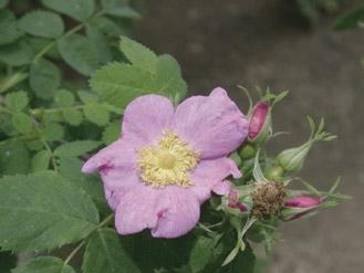
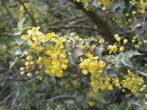
44 Design Guideline 3 - Planting Patterns, Density, and Setback Guidelines Landscapes are to be designed with assistance of planting experts to arrange and group native plants into naturalized patterns that reflect their cultural needs, adaptations, and companion species. For example, riparian trees prefer locations where seasonal moisture collects; evergreen oaks are well adapted to slopes and deeper soils; evergreen shrubs and scrub species are often best suited to full sun and drier locations, grasses and perennials are suited adjacent to pavement and help develop soil quality. It is important during the site analysis step to assess soils, topography, hydrology, and microclimate to develop the planting patterns for each site. Landscape plantings shall also include appropriate setbacks from pavement, walls, and structures (Fig ). Setback guidelines are provided for each species of plant in Appendix B. These setbacks are intended to reduce potential problems from roots, trunks and branches as plants mature to larger sizes. Exceptions can be made for trees by using 24" linear root barriers at the service road pavement edge (Fig 8.12, 8.15). With the use of a root barrier the tree setback distance can be halved. Large shrubs will still require the designated setback to accommodate their spread. Planting patterns and densities shall also consider the safety of pedestrians, joggers and cyclists along all trails and provide sufficient line-of-sight clearance near roads and intersections. A special 17' setback zone has been established along the entrenched reaches of the river to provide for maintenance and emergency vehicle access (page 15). This zone is designated to be a Limited Landscape Zone and is the primary location for service roads and repair work along the river. Plantings in this zone may be heavily disturbed or removed if repair or emergency access is required. Landscape plantings in this zone are restricted to low growing species, not to exceed 3-5' in height. Plantings of trees and shrubs outside this zone are not subject to these size restrictions. Figure 8.7 Sugar bush (Rhus ovata) (Photo by Barbara Eisenstein) Figure 8.8 Golden currant (Ribes aureum var. gracillimum) (Photo by Barbara Eisenstein) Figure 8.9 Mexican elderberry (Sambucus mexicana) (Photo by Barbara Eisenstein) Part II - LAR Planting Guidelines 30
45 100' o.c. Expansion Joints 5' Mixed Planting Area: 5' Low Groundcovers, Perennials, and Shrubs River Channel Channel Wall Expansion 100' o.c. Typ. A Cold o.c. Typ. Vertical Wall Public Right-of-Way Varies 17' Varies 12' 3'-5' wide Mixed Planting Zone: Low Groundcovers, Perennials, and Shrubs A' See Section A-A' (Fig 8.9) Naturalized Stands of California Sycamore and Coast Live Oak with Mixed Native Understory Planting of Various Heights Figure 8.10 Design Guideline 3: Planting Patterns and Setbacks with Planting Pockets Along Trapezoidal & Rectangular Entrenched (Plan View) NOTES: -12' Multi-use Trail/Service Road with planting areas adjacent to vertical and trapezoidal walls within the 100' expansion joint sections; edge of planting pockets should be 5' from expansion joint. - Setback distances for trees can be halved if a 24" linear root barrier is used immediately next to the road outside of the 17' wide Limited Landscape Zone (Fig 8.12, 8.15). - Landscape plants located within the unpaved areas of the Limited Landscape Zone shall not exceed 3-5' in height and shall provide for user safety, visibility and emergency access. California sycamore trees are restricted to the edge of this Zone. - Other groupings of California sycamores as well as coast live oaks and associated native species planted beyond the 17' Limited Landscape Zone are not subject to the same height restrictions Design Guidelines
46 100' o.c. Expansion Joints River Channel Channel Wall Expansion 100' o.c. Typ. B Cold o.c. Typ. Vertical Wall Public Right-of-Way Varies 17' Varies 12' 5' Mixed Planting Zone: Low Groundcovers, Perennials, and Shrubs B' See Section B - B' (Fig 8.9) Mixed Stands of California Sycamore and Coast Live Oak with Associated Native Understory Planting of Various Heights Figure 8.11 Design Guideline 3: Planting Patterns and Setbacks Along Trapezoidal & Rectangular Entrenched (Plan View) NOTES: -17' wide Limited Landscape Zone is established along all entrenched sections of the river. A 12' wide straight Service Road can be constructed in this zone. - Setback distances for trees can be halved if a 24" linear root barrier is used immediately next to the road outside of the 17' wide Limited Landscape Zone (Fig 8.12, 8.15). - Landscape plants located within the unpaved areas of the Limited Landscape Zone shall not exceed 3-5' in height and shall provide for user safety, visibility and emergency access. California sycamore trees are restricted to the edge of this Zone. - Other groupings of California sycamores as well as coast live oaks and associated native species planted beyond the 17' Limited Landscape Zone are not subject to the same height restrictions. Part II - LAR Planting Guidelines 32
47 Figure 8.12 Design Guideline 3: Planting Patterns and Setbacks Along Trapezoidal & Rectangular Entrenched (Cross-Section View) 17' Limited Landscape Zone 5' 12' Varies Planting Pocket Multi-use Trail/ Service Road Private Property Verticle Wall Section A - A' Planting Areas along River Wall without Root Barrier Test Soils 17' Limited Landscape Zone 12' 5' Varies Multi-use Trail/ Service Road Private Property Verticle Wall Section B - B' Service Road along River Wall with Root Barrier Root Barrier - 24" Test Soils Design Guidelines
48 Figure 8.13 Design Guideline 3-2:1 Levee Slope Planting (Cross-Section View) Tree planting to be restricted to lower 20% of 2:1 Levee Slopes Public Right-of-Way Varies California Sycamore Coast Live Oak nce Test Soils Paving Slope, Southern Sycamore Riparian Woodland, or Coast Live Oak Woodland Communities, Coastal Sage Scrub, or Alluvial Fan Sage Scrub Communities Multi-use Trail/ Service Road Paving Mixed Native Plantings River Channel Levee Part II - LAR Planting Guidelines 34
49 Figure 8.14 Design Guideline 3-3:1 Levee Slope Planting (Cross-Section View) Public Right-of-Way Varies Tree planting to be restricted to lower 50% of 3:1 Levee Slopes California Sycamore Coast Live Oak Multi-use Trail/ Service Road Paving Fence Mixed Native Plantings - No Size Restrictions 3:1 Slope Paving Test Soils, Southern Sycamore Riparian Woodland, or Coast Live Oak Woodland Communities, Coastal Sage Scrub, or Alluvial Fan Sage Scrub Communities River Channel Levee Design Guidelines
50 Figure 8.15 Design Guideline 3-4:1 Levee Slope Planting (Cross-Section View) Public Right-of-Way Varies Frequent California Sycamore Frequent Coast Live Oak Intermittent Coast Live Oak Occasional Coast Live Oak Fence Multi-use Trail/ Service Road Paving 4:1 Slope Paving, Southern Sycamore Riparian Woodland, or Coast Live Oak Woodland Communities Test Soils, Coastal Sage Scrub, or Alluvial Fan Sage Scrub Communities Root Barrier - 24" River Channel Levee Tree planting throughout all of 4:1 levee slopes but concentrated on lower slopes. Part II - LAR Planting Guidelines 36

51 Design Guideline 4 - Species and Structural Diversity Landscape plantings are to be designed to include a range of native plants with the intent of achieving similar levels of species diversity as occurs in natural landscapes. As a result, plantings are to include a variety of perennials and shrubs as well as long-lived shrubs and trees. The diversity of the landscape plantings are to provide a variety of benefits ranging from soil development, erosion control, resistance to disease, and wildlife value to educational benefit, seasonal character, and community involvement. In order to achieve the richest wildlife habitat opportunities, designers should seek to achieve diverse vertical structure in their projects by including the full range of vegetative layers present in both the Short List or the native community - from tree canopy where applicable, through mid-layer and understory species as enumerated on the lists. The diversity of bird species, in particular, that may occupy a given landscape is closely related to the structural diversity present. Horizontal structure should be sought by creating mosaics of complementary associations. When designing habitats targeted for specific wildlife species, a qualified wildlife and/or restoration ecologist should be consulted. Design Guideline 5 - Existing Landscape Plants Landscape plants currently existing in the public ROW are to be assessed for their value and role in new landscaping projects. The goal of these guidelines is to achieve native landscape plantings along the Los Angeles River system as completely as possible over time. Existing, non-invasive, exotic species may be retained until senescence then replaced with appropriate native plants. Therefore, long term management actions and replacement plantings are to emphasize strictly indigenous native species. Figure 8.17 Laurel sumac (Malosma laurina) (Photo by Barbara Eisenstein) Design Guideline 6 - Gateways Gateways serve the important function of being a visitor s first point of contact with the parkway beyond. Because they are both a physical control point and a transitional element, gateways are used to introduce the park s theme -- a recognizable feature that can be associated with a park. Gateways should project a sense of the natural environment that lies beyond the entry point and a theme that is echoed consistently throughout the park, and assist the casual visitor with a sense of feeling at home in the landscape. Figure 8.16 California wild rose (Rosa californica) (Photo by Barbara Eisenstein) Los Angeles River gateways are recognized as special situations and three exceptions have been made to allow greater design latitude in these areas Design Guidelines
 due to higher maintenance requirements; Species native to Los Angeles County, but not present in the Los Angeles River watershed such")
52 2. Other indigenous native plant species that are not included on the Short List or Community Lists in Appendix B may be used, such as: Species normally included in one of the associations but eliminated for Los Angeles River ROW landscaping (annuals, bulbs) due to higher maintenance requirements; Species native to Los Angeles County, but not present in the Los Angeles River watershed such as, redbud (Cercis occidentalis), California buckeye (Aesculus californica), foothill pine (Pinus sabiniana), and bush anemone (Carpenteria californica). 3. Gateways are areas where larger trees, including 24" box specimens rather than the 1 and 5 gallon trees may also be appropriate. Visitors can gain a sense of the mature landscape as the smaller trees in the rest of the area grow. Figure 8.18 California walnut (Juglans californica var. californica) (Photo by Barbara Eisenstein) 1. The listed indigenous native species can be combined with a limited number of other California species, cultivars and hybrids of natives to achieve greater visual impact. It is anticipated that these will occur at street intersections, trail crossings, and access points from parks. For these gateways (and other exceptional situations), plants that are not native to the Los Angeles River watershed may be considered on a case-by-case, plant-by-plant basis by the County. However, the total number of plants that are not native to the Los Angeles River watershed shall not exceed 5% of the total number of plants of the same pot size in any given project. (Example: A project designer wants to use gallon sized California buckeyes (Aesculus californica) in a gateway planting. Since this plant does not naturally occur within the Los Angeles River watershed, there must be a minimum of gallon sized plants that are native to the watershed in the project for this request to be considered by the County.) Design Guideline 7 - Plants That Should Never Be Planted Along The River Despite recent efforts to restore native plant communities along the river, miles of riverside landscapes are currently dominated by exotic weedy plants. Many of these are escapes from landscape plantings, such as Mexican fan palm (Washingtonia robusta) and fountain grass (Pennisetum setaceum) that are adapted to disturbed soil conditions. Such species may be attractive to the uneducated eye, but their aggressive domination of riverside landscapes displaces opportunities for native plant species and the habitats they shape. The resultant simplification of riverside habitats reduces the diversity of plant and wildlife species that may be supported there. Aggressive exotic plant species shall not be allowed in new plantings and all new projects shall include measures to eradicate on-site weeds prior to planting and through follow-up maintenance. In short, only plant species included among the accompanying Short List or Plant Community Lists shall be allowed in plantings along the river, without specific recommendations from a qualified restoration ecologist. The California Invasive Plant Council (Cal-IPC) is an excellent source for the most current information on invasive plant species threats and management techniques. For more information, including the most recent Cal-IPC list, Exotic Pest Plants of Greatest Ecological Concern in California consult the Cal-IPC web site: Additional information is available through the California Native Plant Society website: Part II - LAR Planting Guidelines 38
.")


53 Hardscape Elements - An Overview The development of recreational open space along the river and wash requires the provision of certain basic amenities that provide security, safety, and information to the public. Fencing and lighting are essential where public security is an issue, and should be the first elements to be considered where project implementation is to be phased (Fig 8.19). Aesthetic elements provide inspiration and have special appeal as an attraction that fosters a unique character for a place. Figure 8.19 Decorative tubular steel fence along the Los Angeles River in Studio City Figure 8.20 River rock edging between decomposed granite path and raised planting bed on the Los Angeles River Figure 8.21 Outdoor classroom amphitheatre along the river in Studio City Guidelines for quality control and durability of materials have been developed to offer suggestions in the design process, and to promote a sense of visual character that is in keeping with the river environment. They are intended to stimulate imagination, innovation, and variety. Basic standards that meet minimum requirements are provided for several types of amenities including fencing and lighting. This selection is more generic, and is potentially lower in cost than custom pieces. To establish a meaningful urban river identity, the selection and design of river amenities should be in keeping with a riparian character. A material palette has been developed to provide direction at the site design level. While the primary design goal is to suggest an overall continuity to the river corridor, local character in terms of an urban, rural, natural, or coastal flavor can be explored within each individual city and river reach through the use of indigenous materials where appropriate. Universally appropriate construction materials are stone, metal, and, to a limited extent, concrete. Each provides longevity and maximum durability, particularly in heavy use areas. Creative use of these materials should recognize site context in the design process. Construction Materials Stone: Stone, particularly local river rock, is and historically always has been the material of choice along the river and wash (Fig ). Its inherent natural beauty provides strong aesthetic Design Guidelines


54 character, and is useful for walls and custom site furnishings (Fig ). Other indigenous types of stone, including granite, sandstone, Bouquet Canyon related types, Santa Maria related types, and conglomerates are also appropriate. Metal: Metal is a utilitarian material with tremendous creative potential (Fig 8.19, 8.24). Wrought iron and steel are particularly useful for fencing, structures, site furnishings and artwork and can be integrated in any design scheme from the rustic to the sleek. Concrete: This is an extremely durable and versatile material with a wide array of earthy colors, patterns and textures that can be useful in certain circumstances (Fig 8.25, 8.26). It is a very urban material that requires thoughtful and sparing use on the river, particularly in natural areas. Figure 8.22 Example of stone boulder bollard, stone header, and other appropriate materials in Egret Park Permeable Surfaces Decomposed Granite (D.G.): a stable, natural looking paving material suitable for most kinds of recreational pathways. It is inexpensive, easy to install and readily available in its common form. D.G. can be found in a variety of different colors, and granular sizes. A larger granular size is recommended, as fine D.G. becomes slippery when wet. Where erosion is a concern, D.G. should be protected with a binder such as Polypave, Stabilizer, or approved equal. D.G. should not be used on sloped areas unless a drainage system is installed. Non-grouted pavers, or puddle mortared stone pavers: There are many types of paving block, designed to be installed on a permeable sand base which are being used in urban areas instead of concrete. The flexible quality has advantages over time in being able to handle earth movement. Manufacturers offer a wide selection of colors and shapes to be used creatively in public facilities. Porous asphalt / porous concrete: open, coarse aggregate held together by asphalt concrete or cement. Figure 8.23 Stone steps with metal railing on the Los Angeles River at Rattlesnake Park Problems can occur with silting which reduces permeability if surfaces are not cleaned and maintained regularly to allow maximum water percolation. Gravelpavers: made of recycled plastic, comes in rolls, easily installed, and the spaces filled with gravel. Part II - LAR Planting Guidelines 40


55 Grasspavers or Turf Block: made of recycled plastic or concrete blocks, comes in rolls, easily installed, good for eroded or high traffic areas, and considered ADA accessible. Although turf is not recommended in the river easement, the spaces can be seeded or plugged with native grasses and wildflowers. Use sparingly. Figure 8.24 Curved steel bench and river rock wall on the Los Angeles River Figure 8.25 Concrete, textured parapet wall along the Los Angeles River in Long Beach Recycled Materials Recycled Plastic Lumber: Because plastic based materials can be burned, they are not suitable as a building material on the river. There are a few products such as Trex, for example, that have value in limited applications such as header board. The product is made of recycled plastic and wood shavings and has a natural appearance. It is available in most lumber sizes and is durable, low cost and easy to install with wood working tools. Although it cannot replace wood, structurally it is more flexible and considered very low maintenance. For sources see Appendix C. Recycled Broken Concrete: Broken concrete pieces provides an interesting, durable, and environmentally-friendly alternative to paving stones, stepping stones or river rock walls (Fig 8.26). Check with local concrete recyclers for an inexpensive supply. Figure 8.26 Broken concrete seatwall at Los Angeles Riverwalk at Los Feliz Boulevard Design Guidelines
56 9.0 Site Preparation Guidelines Site Preparation Guideline 1 - Capture and Infiltration of Rainfall All project sites are to be studied to identify optimal locations and possible grading actions that will increase the capture and retention of rainfall to help sustain the growth of the native plantings* (Fig ). Areas that are determined to have high retention potential are best suited to riparian species such as California sycamore and Fremont cottonwood. Infiltration of rainfall can be enhanced by the installation of perforated pipes within the dripline of larger shrubs and tree species. However, adequate drainage of the area may be required for heavier storms or clogged systems. River Channel Planting Area Multi-use Trail/ Service Road H2o Root Barrier - 24" Public Right of Way Setback Planting Varies Private Property H2o Perforated Pipe Figure 9.1 Proposed water management in public easement applying the landscape and plant palette standards with participation from adjacent land owners. (Also see Fig 8.12, page 33) Site Preparation Guideline 2 - Weed Abatement All weeds should be removed by hand and mechanical means where feasible. When hand and mechanical means cannot be used, herbaceous grasses and forbs can be removed after seed germination and foliage growth is initiated by seasonal rainfall or irrigation applications. EPA approved, glyphosate based, systemic herbicides such as Roundup or Rodeo can be applied to weeds in compliance with manufacturer guidelines. Woody and thick-stemmed exotics can be eradicated with the cut-and-dab technique and with herbicides. This weed abatement technique requires plant stems to be cut and a herbicide application of 33% solution of Roundup or Rodeo applied to the fresh cuts. All treated weeds need to be removed as much as possible from the site to discourage resprouting or delayed seed dispersal. Layers of mulches (organic or inorganic) can also be used to cover exposed soil and further inhibit the growth and survival of weeds. Site Preparation Guideline 3 - Soil Amendment Soil testing results are to be used to provide guidance for container planting soil amending and backfill conditioning. Organic and biological approaches to soil improvement are to become part of the landscape planting and management program. These approaches can include the addition of mycorrhizal inoculation, gypsum, and composted organic matter. If necessary, the project plant or restoration ecologist should prepare a mycorrhizal inoculation program for site soils, including specific types and quantities of inocula, as well as appropriate installation techniques. Recommended guidelines for mycorrhizal inoculation are provided in Appendix A, pages Note: Most soil analysis is referenced to commercial agricultural crops (though this is often not stated). California native plants typically inhabit (and thrive in) areas with relatively low soil fertility. Therefore, the soils report fertility section must be interpreted by someone who is experienced and knowledgeable of California native plant horticultural requirements/ parameters. * CASQA, Stormwater Best Management Practice Handbooks, June Part II - LAR Planting Guidelines 42
57 Figure 9.2 Site Preparation Guidelines 1-3: Swale (Cross-Section View) Planting Area Multi-use Trail/ Service Road Private Property Vertical Wall Grade Site to Capture and Infiltrate Rainfall Root Barrier - 24" 10% Max. Slope Grade Site to Capture and Infiltrate Rainfall Amend soils as necessary in specific reference to soils report Multi-use Trail/ Service Road Private Property Vertical Wall Root Barrier - 24" 10% Max. Slope Amend soils as necessary in specific reference to soils report Grade Site to Capture and Infiltrate Rainfall NOTES: - Grade site to capture and infiltrate rainfall - Provide mycorrhizae, when necessary - Complete weed eradication and site clearing Site Preparation Guidelines
58 Figure 9.3 Site Preparation Guidelines 1-3: Slope (Cross-Section View) Fence Paving Multi-use Trail/ Service Road Amend soils as necessary in specific reference to soils report Grade Site to Capture and Infiltrate Rainfall River Channel Root Barrier - 24" Multi-use Trail/ Service Road Fence Paving Grade Site to Capture and Infiltrate Rainfall Amend soils as necessary in specific reference to soils report River Channel Root Barrier - 24" NOTES: - Grade site to capture and infiltrate rainfall - Provide mycorrhizae, when necessary - Complete weed eradication and site clearing Part II - LAR Planting Guidelines 44
59 10.0 Landscape Planting Guidelines Planting Guideline 1 - Contract Collecting and Growing Seed and container plants of indigenous natives are to be obtained through contracts with qualified seed companies and nurseries. Each project is to be managed to provide adequate lead time for collection and propagation with the assistance of the project planting expert. Contractors should be prepared to show seed collection permits for propagule collection, and documentation that tracks the plants through the growth process (Appendix A). Planting Guideline 2 - Container Plant Sizes and Installation Guidelines Landscape plants are to be established from smaller plant sizes where practical. Preferred container sizes range from bands, 1 gallon and 5 gallon containers for grasses, perennials, and shrubs; trees can be planted from 1, 5 and 15 gallon containers (Fig ). Gateways are special situations that may require larger container sizes, such as 24" box, to more quickly attain the look of a mature landscape (Also see Design Guideline 6 - Gateways, pages 37-38). project. All plants are to be thoroughly watered upon installation to compact soil and settle plants to natural soil depth. Planting areas that are not seeded are to be covered with 3-6 of organic mulch in compliance with the attached Planting Specifications in Appendix A. Planting Guideline 4 - Seed Planting Though often erratic and generally less dependable, seed planting of native grasses, perennials, and shrubs can be successfully established through various seeding techniques including imprinting, hand broadcasting, and hydroseeding. Seeds from species such as oaks and walnuts can be established through direct seeding techniques. Specific seed planting actions are to be recommended by the project plant or restoration ecologist. Guidelines for seed planting are provided in the Planting Specifications in Appendix A. A combination of staking and installation of protective wire cages is recommended for small trees and shrubs to protect plants from vandalism and herbivory damage (Fig 10.2). In ground gopher cages may be necessary to protect plant roots underground from squirrels, pocket gophers and gophers (Appendix C). Planting Guideline 3 - Installation Schedule Planting of seed and container plants is to occur in late fall through winter to benefit from seasonal rains. The project plant or restoration ecologist is to prepare a specific planting schedule for each Landscape Planting Guidelines
60 Figure 10.1 Planting Guideline 1: Plant Communities of California Native Species Shrub and Tree Planting Setback See Spacing Guidelines Appendix B and Design Guideline 3 (Pg 30-36) Varies Public Right-of-Way Landscaping Opportunities Trees with Temporary Irrigation Fence Multi-use Trail/ Service Road Paving Paving Root Barrier - 24" River Channel Perforated Drain Pipe Mulch or Hydroseed on Slopes Southern Sycamore Riparian Woodland, or Coast Live Oak Woodland Communities in areas of more moisture & deeper soils Coast Live Oak Woodland, Coastal Sage Scrub, or Alluvial Fan Sage Scrub Communities with Periodic Woodland Trees in drier/sunnier areas NOTES: - Contract to collect Los Angeles River watershed seed and grow native species - Small container sizes are preferred - Locate most trees in areas that have deeper soils and receive more moisture - Install seed and container plants in late fall to winter per planting specifications - Locate container plants according to setback guidelines in Design Guideline 3 (pages 30-36) and Appendix B Part II - LAR Planting Guidelines 46
61 Figure 10.2 Planting Guideline 2: Individual Container Plants Protective Wire Cage Temporary Drip Irrigation Tubing Backfill Per Guidelines 3" - 6" Mulch Layer Scarified Planting Pit 12" min. Existing Soil 1 Gallon 6" x 8" Gopher Cage Temporary Drip Irrigation Tubing Backfill Per Guidelines 3" - 6" Mulch Layer Scarified Planting Pit 18" min. Existing Soil 5 Gallon 12" x 15" NOTES: - Contract to collect and grow native species - Small container sizes are preferred - Install gopher cages where necessary - Install container plants in late fall to early winter per planting specifications - Add 3-6" layer of mulch to within 6" of plant base Landscape Planting Guidelines
62 11.0 Landscape Maintenance Guidelines NOTE: For a complete discussion of maintenance, consult the Los Angeles River Landscape Maintenance Manual (draft). Maintenance Guideline 1 - Supplemental Irrigation The design and installation of supplemental irrigation systems to sustain new landscape plantings is discretionary. The landscaping goal is to establish communities of native plants in a manner that encourages self-reliance and survival after the first three years of planting. In this regard, low volume drip and overhead spray irrigation systems may be designed to assist in the initial plant establishment stages, but long term watering is to be discouraged. Overhead spray systems should be used only when necessary and should be designed to use heads with low-precipitation rate nozzles to reduce possible problems with run-off and erosion. The application of supplemental irrigation water for California native species is recommended primarily during the winter months with the intent to avoid winter drought stress to newly planted plants. Winter irrigation can be very helpful in maintaining soil moisture when there are long periods of time between winter rains. Summer and fall watering may be limited in accordance with prevailing site and environmental conditions until the following winter rain cycle begins. After the first year of establishment, the decision to provide additional supplemental irrigation during the summer should be made by the project plant or restoration ecologist. Specialty plantings in high use recreation areas, at road intersections, or in highly paved areas may require additional supplemental irrigation for an extended number of years to maintain the vitality of the landscape. In these instances, the use of bubbler and drip irrigation systems is recommended where feasible. As-built drawings of all irrigation systems shall be completed and submitted to the County for future use. Maintenance Guideline 2 - Extended Maintenance Program The project proponent is required to prepare a 3-5 year monitoring and maintenance program for all landscape plantings and to designate who will be in charge of all short and long-term maintenance actions. This program is to define a schedule for observing and recording landscape performance with the goal of identifying actions that are needed to improve planting success. Such actions may include replacement plantings needed to replant areas where container plants have died or insufficient seed germination has occurred. The project plant or restoration ecologist is to help prepare this program and to incorporate appropriate elements of the maintenance specifications provided in Appendix A. Maintenance Guideline 3 - Pruning and Removal of Plants Landscape plantings are to be maintained in a manner that helps achieve natural form, diversity and density among plants. Trimming, pruning and removal of plants is to be done under the guidance of a qualified native plant specialist and to avoid shearing and out-of-season cutting and pruning. Additional pruning and removal of plants shall be done to maintain public safety and access for service and emergency actions. Maintenance Guideline 4 - Weeding and Supplemental Mulching The monitoring and maintenance program shall provide for routine landscape inspections to inspect and test irrigation systems, manage weed growth and to assess the need to provide periodic augmentation of mulches (to maintain a depth of 3-6"). Removal of weeds by hand and mechanical means is recommended where feasible. EPA approved, glyphosate based, systemic herbicides such as Roundup or Rodeo can be applied to weeds in compliance with manufacturer guidelines when hand and mechanical means are not possible. Additional mulch is recommended to cover exposed soil and further inhibit the growth of weeds. Part II - LAR Planting Guidelines 48
63
64
65 ACKNOWLEDGEMENTS For the many meetings, phone conversations, information, and insights LARMP Landscape Guidelines - Jan 2004 PREPARERS Jill Benshoof Jason Casanova Barbara Eisenstein Verna Jigour Maria Lopez Ellen Mackey Bart O Brien Robert Perry Jan Sandgren Lacey Withers COLLABORATORS Michael Amescua Ileene Anderson Karen Bane Vik Bapna David Briley Diego Cadena Doug Campbell James Campbell Pauline Chan Joni Clayton Dan Cooper Cynthia D Agosta Steve Davis Charles Devaney Joe Donaldson Lynne Dwyer Mike Evans Belinda Faustinos Bob Fawcett Arthur Golding Fernando Gomez Chuck Gonzales Joe Hall Jessica Hall-Valdez Richard Hansen Peg Henderson Richard Hurd Carrie Inciong Mie Joness Meredith Kaplan Chris Kroll Jim Lang Ted Masigat Michelle Mowery Vicky Musgrove Orlando Nova Steve Ramsey Scott Reese Julie Riley Mike Roberts Claire Robinson Achva Stein David Sundstrom Bob Sussman Ramiro Vallalvazo Greg Watkins Scott Wilson Mark Wimer Melanie Winter Landscape Architect Los Angeles & San Gabriel Rivers Watershed Council Los Angeles & San Gabriel Rivers Watershed Council Verna Jigour Associates County of Los Angeles Department of Public Works (Watershed Management) Los Angeles & San Gabriel Rivers Watershed Council; Metropolitan Water District of Southern California Rancho Santa Ana Botanic Garden Robert Perry Associates Withers & Sandgren Withers & Sandgren ASL Consulting Engineers LOS ANGELES RIVER MASTER PLAN ADVISORY COMMITTEE Public Artist California Native Plant Society California Coastal Conservancy County of Los Angeles Department of Public Works (Watershed Management) Calvin Ahbé Landscape Architects County of Los Angeles Department of Public Works (Flood Maintanence) Landscape Architect, Campbell & Campbell El Nativo Growers Los Angeles Department of Transportation Mockingbird Nurseries Audubon California Consultant City of Los Angeles Rec & Parks Augusta Tomorrow Inc. Riverfront Development Review Jones and Stokes Landscape Architect/Friends of the Los Angeles River Tree of Life Nursery Rivers and Mountains Conservancy City of Los Angeles Rec & Parks Architect/Chair, Los Angeles & San Gabriel Rivers Watershed Council Landscape Ethic Committee Santa Monica Mountains Conservancy Lakeside Golf Club Archives City of Santa Cruz (Planner) San Lorenzo River North East Trees Landscape Architect/Artist National Park Service City of San Antonio Parks and Recreation County of Los Angeles Department of Public Works (Watershed Management) County of Los Angeles Department of Public Works (Architectural Engineering) National Park Service California Coastal Conservancy City of Santa Cruz County Parks and Recreation United States Army Corps of Engineers Los Angeles Department of Transportation City of Ventura (Stormwater Management) City of Los Angeles Bureau of Street Lighting San Antonio River Authority Chief Engineer City of Glendale City of Los Angeles Rec & Parks United States Forest Service (Sign Coordinator) North East Trees Professor of Landscape Architecture, University of Southern California Long Beach Strategic Plan Matilija Nursery United States Forest Service (Landscape Architect) United States Forest Service (San Francisco Office) North East Trees LA Breeding Birds The River Project 51
66
67 Appendix A Supplemental Planning Information 53
68
69 12.0 The Permit Process for Project Implementation The design of recreational amenities and landscape plantings for the Los Angeles River requires a series of steps and procedures to achieve optimum success. These include the development of plans and specifications that meet the permit criteria of the County of Los Angeles Department of Public Works. Project proponents must submit plans for approval by the County on a project by project basis. Permittee is responsible for adhering to all requirements. Requirements for jurisdictional reviews and permits procedural issues are as follows: Background Review 1. Review Los Angeles River Master Plan documents to identify local, site-specific opportunities 2. Meet with County and City staff 3. Review other relevant documents 4. Meet with sponsoring group and community Evaluate Site for Opportunities and Constraints 1. Determine maintenance jurisdiction 2. Determine all land ownerships and easements/rows 3. Contact all agencies and owners for concept approval 4. Identify water source (point of connection) and funding responsibility 5. Perform functional and aesthetic assessment of the site 6. Assess topographic, hydrologic and microclimate conditions 7. Conduct agronomic and biological activity soil test 8. Determine existing utilities (gas lines, water lines, electric lines) 9. Hire professionals for plan development including landscape architect and ecologist Conceptual Design Stage 1. Develop a site specific program 2. Develop preliminary plant palettes per planting guidelines 3. Develop conceptual planting patterns and grading actions 4. Prepare section-view illustrations of planting program 5. Summarize key plant palettes, planting and irrigation techniques 6. Submit to County for review 7. Begin contract growing process Schematic Design Stage 1. Prepare design and irrigation plans with preliminary details 2. Consult with existing municipalities regarding irrigation equipment and design guidelines 3. Identify seed and container planting techniques 4. Prepare comprehensive plant palettes including species types, quantities, sizes 5. Continue contract growing process 6. Prepare preliminary cost estimate and project specifications Monitoring and Maintenance Program 1. Prepare irrigation schedule and checklist of maintenance activities in accordance with The Los Angeles River Landscape Maintenance Manual (in preparation) Permit Process for Project Implementation
70 2. Prepare inspection and replacement planting program 3. Prepare pruning and mulching guidelines 4. Prepare a 3-5 year extended monitoring and maintenance program 5. Responsible agencies maintaining the landscape must be listed Technical Drawings and Specifications 1. Prepare complete set of technical drawings and specifications for bid purposes. 2. Submit technical drawings and specifications to County for review and approval. Landscape plans, irrigation plans and specifications to be prepared by a registered landscape architect licensed to practice in California. The design drawings and specifications shall conform with the County of Los Angeles Department of Public Works and/or American Public Works Association (APWA) Standard Plans and Specifications requirements. For structural amenities not shown in the County or APWA standard plans, the designer should provide detailed drawings and design calculations, prepared, signed, and stamped by a California Registered Civil or Structural Engineer. 3. Submit maintenance and monitoring programs both 12-month and 3-years as part of the technical specifications required for project approval (see pages and Maintenance Manual (in preparation)). 4. Require underground service alert (see below). As-Built Drawings 1. Provide updated planting plan and irrigation schematics (as-builts or record drawings) to the County as necessary. The County s Role The County of Los Angeles Department of Public Works has the broadest influence and is therefore the logical agency to continue the leadership role in the implementation of a continuous river greenway corridor as specified in the Master Plan. The achievement of a continuous river greenway corridor will take a concerted and sustained effort by the County and each river municipality. The public right of way provides limited area for corridor improvements. Modifications of existing land use conditions, zoning changes, and lease agreements initiated by others will be necessary to implement the directives of both flood management agencies as published in two documents 1) The Los Angeles River Master Plan issued by the Los Angeles County Department of Public Works in 1996, and 2) the Los Angeles River Recreational Development Master Plan and Environmental Assessment as mandated by the United States Army Corps of Engineers, adopted in Call 2 Full Working Days In Advance DigAlert Sponsored by the Underground Service Alert of Southern California (USA/SC), a non-profit mutual-benefit organization dedicated to ensuring public safety and that of workers of underground utility lines. Check their web site for current rate structure. Appendix A 56
71 13.0 Supplemental Project Specifications For Contractors These specifications are provided to help project proponents achieve the goals and purposes of the Los Angeles River Planting Guidelines. These specifications are not complete by themselves. They have been prepared to include specific materials, installation guidelines, and maintenance actions that are to be integrated into the full project specification package submitted by a project proponent. Planting and Irrigation Materials Container Plants: The contractor shall acquire all plant material of the required type, sizes and quantities through sources approved by the project proponent's plant or restoration ecologist. The contractor shall furnish evidence to County of Los Angeles Department of Public Works that the plant material was grown exclusively from propagules indigenous to the Los Angeles River watershed. Substitutions or changes to the planting program will not be permitted without written approval from the project proponent's plant or restoration ecologist. Plants shall be well shaped, vigorous, with healthy, well developed root systems. Plants shall not be rootbound. Plants shall be healthy, and free from disease, harmful insects and insect eggs, sun-scald injury, disfigurement and abrasion. Plants shall be typical of the species or variety as conforming to the Plant Palettes of the these Landscaping Guidelines. Plants shall be furnished in sizes indicated on the drawings. Seed: The contractor shall acquire all seed material of the required type, sizes and quantities through sources approved by the project plant or restoration ecologist. The contractor shall furnish evidence that the collected seed is exclusively from Los Angeles River watershed sources. Seed not required to be labeled under the California Food and Agricultural Code shall be tested for purity and germination by a seed laboratory certified by the Association of Official Seed Analysts, or a seed technologist certified by the Society of Commercial Seed Technologists. Seed shall have been tested for purity and germination not more than one year prior to application of seed. Results from testing seed for purity and germination shall be furnished to the project restoration ecologist prior to applying seed. Seed treated with mercury compounds shall not be used. Legume seed shall be pellet-inoculated with a viable bacteria compatible for use with that species of seed. All inoculated seed shall be labeled to show the mass of seed, the date of inoculation, and the mass and source of inoculant materials. Legume seed shall be pellet-inoculated in accordance with the provisions in Bulletin 1842, Range-Legume Inoculation and Nitrogen Fixation by Root-Nodule Bacteria, of the University of California, Division of Agriculture and Natural Resources. Inoculant shall be added at the rate of 2 kg of inoculant per 100 kg of legume seed. Inoculated seed shall be sown within 90 days of inoculation. Seed shall be delivered to the site in original sealed packages bearing the supplier s guaranteed analysis for percentages of mixture, purity, germination, hard seed, weed seed content, and inert material. Labels shall be in conformance with AMS-01 and applicable state seed laws. Weed seed shall not exceed 1 percent by weight of the total mixture. Wet, moldy, or otherwise damaged seed shall be rejected Supplemental Project Specifications
72 Compost: Compost shall be derived from green material consisting of chipped, shredded or ground vegetation or clean processed recycled wood products, or a Class A, exceptional quality biosolids compost, as required by US EPA, 40 CFR, part 503c regulations, or a combination of green material and biosolids compost. The compost shall be processed or completed to reduce weed seeds, pathogens, and deleterious material and shall not contain paint, petroleum products, herbicides, fungicides or other chemical residues that would be harmful to plant or animal life. Other deleterious material such as plastic, glass, metal or rocks shall not exceed 0.1 percent by weight or volume. A minimum internal temperature of 135 degrees F shall be maintained for at least 15 continuous days during the composting process. The compost shall be thoroughly turned a minimum of five times during the composting process, and shall go through a minimum 90 days curing period after the 15 day thermophilic compost process has been completed. Compost shall be screened through a minimum 1/4-inch screen. The moisture content of the compost shall not exceed 25%. Moisture content shall be determined by California Test 226. Compost products with a higher moisture content may be used provided the weight of the compost is increased to equal compost with a maximum moisture content of 25%. Compost shall be tested for maturity/stability with a Solvita Test Kit supplied by the compost producer. The compost shall measure a minimum of 7 on the maturity/stability scale. Nitrogen (N) content of the compost should not exceed 6% and should preferably be much lower, as guaranteed by the compost producer. A low nitrogen compost is recommended as a precaution to reduce weed encroachment onto the planting area. Stabilizing Emulsion: Stabilizing emulsion shall be a concentrated liquid chemical that forms a plastic film upon drying and allows water and air to penetrate. The film shall be nonflammable. Stabilizing emulsion shall be nontoxic to plant or animal life and nonstaining to concrete or painted surfaces. Stabilizing emulsion shall be in a dry powder form, may be re-emulsifiable, and shall be a processed organic adhesive used as a soil binder. Stabilizing emulsion shall be miscible with water at the time of mixing and application. The ratio of total water to total stabilizing emulsion in the mixture shall be as recommended by the manufacturer. Note that at least one manufacturer produces a stabilizing emulsion which can facilitate localized water retention. Such potentially suitable properties should be considered in selecting the stabilizing emulsion. Hydroseed Fiber: Fiber shall be produced from natural or recycled (pulp) fiber, such as wood chips or similar wood materials or from newsprint, chipboard, corrugated cardboard or a combination of these processed materials, and shall be free of synthetic or plastic materials. Fiber shall not contain more than 7 percent ash as determined by the Technical Association of the Pulp and Paper Industry (TAPPI) Standard T 413, shall contain less than 250 parts per million boron, and shall be otherwise nontoxic to plant or animal life. Fiber shall have a water-holding capacity by mass of not less than 1200 percent as determined by the procedure used in the California Department of Transportation s Final Report, CA-DOT-TL , Wa- Appendix A 58
73 ter-holding Capacity for Hydromulch, available at the Transportation Laboratory, 5900 Folsom Boulevard, Sacramento, CA Fiber shall be of such character that the fiber will disperse into a uniform slurry when mixed with water. Water content of the fiber before mixing into slurry shall not exceed 15 percent of the dry mass of the fiber. The percentage of water in the fiber shall be determined by California Test 226. Commercially packaged fiber shall have the moisture content of the fiber marked on the package. Fiber shall be of a natural color to blend aesthetically with the area on which the fiber is to be applied, and shall not stain concrete or painted surfaces. Straw: Straw shall be derived from rice, wheat, or barley. Wheat and barley straw shall not be derived from dry farmed cereal crops. The contractor shall furnish evidence that clearance has been obtained from the County Agricultural Commissioner, as required by law, before straw obtained from outside the County is delivered to the site of the work. Straw that has been used for stable bedding shall not be used. Erosion Control Material: Surface mulch for erosion control and weed abatement may comprise composted wood derivatives such as ground bark, chipped tree trimmings, or other wood waste material free of stones, sticks, and toxic substances harmful to plants and stabilized with nitrogen. Erosion control netting shall be heavy, twisted jute mesh weighing approximately 1.22 pounds per linear yard and 4 feet wide with mesh openings of approximately 1 inch square. Endomycorrhizal Inoculum: Arbuscular mycorrhizal inoculum shall consist of spores, mycelium, and mycorrhizal root fragments in a granular calcined clay carrier. 80% of root fragments shall not exceed 1 inch in length. Inoculum shall not contain significant quantities of leaves, stems, seeds, coarse roots, pebbles, perlite, vermiculite or other materials of such size or in such quantity as to interfere with the proper operation of inoculum dispensing equipment. Commercial inocula shall contain at least 50 propagules of a suitable arbuscular mycorrhizal fungus per cc of bulk inoculum. A propagule is a spore, fragment of fungal mycelium, or piece of mycorrhizal root capable of colonizing host plant roots on the restoration site. The inoculum shall contain one or more species of fungi from the genus Glomus, and may contain one or more species of the genera Sclerocyctis, Gigaspora, Scutellospora, Entrophospora, or Acaulospora. Arbuscular mycorrhizal inoculum shall be viable and healthy, and have sufficient time remaining in its recommended shelf life to compensate for any potential delays in planting. Ectomycorrhizal Inoculum: Ectomycorrhizal inoculum shall contain Pisolithus tinctorius and one or more species of Rhizopogon and shall have no less than a live spore count of 400 propagules per ml of bulk inoculum. No antagonistic pathogens shall be present at significant levels Supplemental Project Specifications
74 Irrigation Components: All pressurized pipe and fittings shall be RTR pipe with solvent welded joints conforming to ASTM D2996, Type Grade 1, Class F, or SAMSS-034, Class 1; or ASTM D1785 and SASO 14 and 15 Class V standards. Lateral and main lines less than 1-1/2" and including 1-1/2" shall be PVC Schedule 40 and meet the requirements of PVC Type 1, Grade 1, and Type 1, Grade II, as determined by ASTM D-1784 and comply with ASTM D-2444 impact test. Lateral and main lines 2" and larger shall be PVC Schedule 80 or Class 315. Fittings shall conform to ASTM D All pipe and fittings shall be free of holes, cracks, blisters, wrinkles, dents and other irregularities. Remote Control Valve Boxes shall be constructed of fiberglass, colored green, with rigid base and sides, and supplied with key, slide, or bolt lock cover. Remote control valve boxes installed within 8 feet of the service road shall be concrete with steel-hinged lockable cover. Irrigation Controller Cabinet shall be locking, weatherproof, antirust, corrosion resistant, and seamless. Solenoid Valve Wire from controller to valves shall be terminated at the controller itself, and shall be of the size and type recommended by the valve manufacturer, with a minimum size of 14 AWG. Wire shall be of the direct burial type. Wire connections at the remote control valves shall be accomplished with molded waterproof PVC plastic connectors. PVC wire connectors shall be UL listed or equivalent. Installation Guidelines Planting Times and Conditions: Installation of landscape plantings shall occur between November 1 st to March 15 th as specified in the schedule prepared by the project plant or restoration ecologist. Planting operations for both container species and seed materials shall be performed only when beneficial results can be obtained. When special conditions warrant a variance to the specified planting schedule, alternative planting times shall be submitted to and approved by the project plant or restoration ecologist. Site Preparation and Grading: The project plant or restoration ecologist shall verify the finished grades as indicated on drawings, and appropriate weed abatement actions have been taken. Areas to be seeded or planted with container plants shall be filled as needed or have surplus soil removed to attain the finished grade. Surface drainage shall be maintained as indicated on drawings. Seeded areas shall be lightly scarified. Finished grade shall be 1/2-inch below the adjoining grade of any paved area. New surfaces shall be blended to existing areas. Biological Soil Testing: Soil samples shall be taken and tested in accordance to the program prepared by the project plant or restoration ecologist upon completion of site grading actions. Mycorrhizal Inoculum: Storage - Mycorrhizal inoculum is living material and must be protected from extreme temperatures. Store it in cool, dry, and well-aerated conditions. All biological material has a shelf life. Determine the expected shelf life and current age of the material from the supplier at the time of purchase. Appendix A 60
75 At no time during storage or application shall inoculum be exposed to temperatures above 90 degrees or below 32 degrees F. Inoculum shall be stored out of direct sunlight and in conditions that assure that the temperature of the inoculum remains below 90 degrees and above 32 degrees F. The inoculum dispensing mechanism shall not be allowed to heat in the sun to temperatures above 90 degrees F. Application - Broadcasting shall be carried out by hand or mechanical device that distributes the inoculum evenly and at the specified rate. Any broadcasting machinery shall not crush, grind, or subject the inoculum even momentarily to excessive pressure or temperature. Broadcast seeders, fertilizer boxes such as those manufactured by Gandy or Clampco, motorized blowers, hydraulic seeders, and even agricultural aircraft have been successfully used to broadcast inoculum. Hydroseeding may be used as an alternative method to apply mycorrhizal inoculum to a project site, particularly on steep slopes and where seed planting is the primary means of establishing new vegetation. Depth of Incorporation - Mycorrhizal inoculum shall be incorporated into the upper 2 to 6 inches of soil by the method described above, or by other approved means that provide similar results. Shallow incorporation (1 to 3 inches) is likely to be advantageous during cool weather, and deeper incorporation (3 to 6 inches) is likely to be advantageous during warm weather. In no case shall the inoculum be allowed to remain on the soil surface longer than 6 daylight hours during cool weather (maximum temperature below 70 degrees F) or one daylight hour during warm weather (maximum temperature above 70 degrees F). Inoculation shall not be carried out if the soil surface temperature is above 90 degrees or below 32 degrees F. Where space permits, inoculum shall be broadcast throughout the site after ripping (disking) to a minimum depth of 6 inches, with ripping teeth spaced not more than 18 inches apart. Broadcasting of inoculum shall be followed by treatment of the soil surface with a spring-tooth harrow implement. (Alternatively: 1.) drag a timber or piece of chain link fence; 2.) trackwalk; 3.) roll the surface with a low-pressure wheel tractor.) In smaller planting spaces, inoculum shall be incorporated by slicing the soil with a blade or spading fork to a depth of four to six inches and dropping inoculum into the resulting openings. Openings in the soil shall be no more than 10 inches apart. Inoculum shall be broadcast on the surface of loose, well-worked soil and incorporated by back-and-forth motions of a garden rake or similar implement. Rate of Inoculation - Inoculation rate shall correspond to 3,600,000 propagules per acre (8,900,000 propagules per ha), or 8300 propagules per 100 square feet (900 propagules per square meter). The application rate of bulk inoculum shall be calculated from the supplier s guarantee of propagule count per unit volume of bulk inoculum. Container Plants: Excavation of Plant Pits - Plant pits shall be dug to produce roughened sides and flat, uncompacted bottoms. When pits are dug with an auger and the sides of the pits become glazed, the glazed surface shall be scarified. The size of plant pits shall be as shown on drawings. When obstructions below ground or poor drainage affect the contract operation, proposed adjustments to plant location, type of plant and planting method or drainage correction shall be submitted to and approved by the project plant or restoration ecologist Supplemental Project Specifications
76 Percolation Test - Tests for percolation shall be done to determine positive drainage of all plant pits. The project plant or restoration ecologist shall be notified in writing of all soil and drainage conditions detrimental to growth of plant material and shall submit proposal for correcting the condition. Backfill and Inoculation of Container Plants - Backfill for planting pits shall comprise 80% site soil, 20% compost depending on soil analysis results. If necessary, areas where mycorrhizal inoculum has not been applied to the site, container plants shall be treated at time of planting by applying inoculum to the root surface within the root zone. During the planting operations, contractor shall ensure that the inoculum is directly interfacing with living roots or placed reasonably close to assure rapid movement of root growth to the inoculum. Application rate for container plants, assuming VAM 80 or comparable granulated inoculum is used: Small containers (liners, etc.) - a pinch 1 gallon - approximately 1 teaspoon 5 gallon - approximately 1 tablespoon Larger containers - apply according to above approximate ratios Container Installation - Plants shall be set plumb and held in position until sufficient soil has been firmly placed around roots or ball. Plants shall be watered immediately upon installation to eliminate air pockets and to establish a plant elevation that matches the surrounding grade (never lower) at the depth at which they were grown in the nursery, or container. Mulching - Areas not planted with seed shall be covered with minimum of 3" to 6" of mulch. No organic mulch shall be placed within 6" of the trunk or stem of container plants. Hydroseeding and Hydromulching: A minimum two step process shall be implemented for applying seeds and endomycorrhizal inoculum by hydraulic seeder. The seed mix and inoculum shall be applied in the first pass by the hydraulic seeder; a protective layer of hydromulch fiber and low nitrogen compost shall be applied on top of this mixture in a second pass. A third step may be considered optional, depending on site conditions. A layer of straw and tackifier can be applied to the project site for additional protection. The hydroseeding method opens the possibility of mycorrhizal inoculation on slopes too steep even for hand labor. Hydroseeding shall consist of mixing and applying, as specified hereafter: seed, mycorrhizal inoculum, and stabilizing emulsion with water to the planting areas. Hydromulching shall consist of mixing and applying compost, fiber, and stabilizing emulsion with water in a second pass over areas that have received the hydroseed mixture. Appendix A 62
77 The hydroseed and hydromulch mixtures should ideally be applied during the fall to take advantage of not only winter rains, but also the cold stratification that may enhance germination of many native plant seeds. Hydroseed and hydromulch materials shall be applied in two (or three) separate applications in the following sequence: a. Seed, endomycorrhizal inoculum, stabilizing emulsion and water b. Compost, fiber, stabilizing emulsion and water c. (Optional) Straw, stabilizing emulsion and water The type and quantity of seed and inoculum shall be determined by the project plant or restoration ecologist. When applicable, rice straw shall be applied at the rate of 3 metric tons per hectare or wheat or barley straw shall be applied at the rate of 4 metric tons per hectare. Incorporation of straw will not be required. The ratio of total water to total stabilizing emulsion in the mixture shall be as recommended by the manufacturer. The equipment to be used and the methods of seeding shall be subject to the inspection and approval of the Contracting Officer prior to commencement of seeding operations. Immediately prior to the commencement of seeding operations, the contractor shall conduct seeding equipment calibration tests in the presence of the project plant or restoration ecologist. Irrigation: Coverage - All drip irrigation systems shall be installed in a manner that is capable of providing multiple emitters to each container plant. At a minimum, the following schedule of emitters is required: Liners, etc. - 1 micro-emitter 1 gallon plants - 2 micro-emitters, one placed at rootball, other at edge of dripline 5 gallon plants - 4 micro-emitters, two placed at rootball, others at edge of dripline 15 gallon plants - 8 micro-emitters, four placed at rootball, others at edge of dripline All spray irrigation systems shall be installed to achieve head-to-head coverage within the limits of the available water pressure, operating standards of the specific irrigation components, and site conditions. Where possible, lateral lines of low volume irrigation systems shall be placed parallel to the contours of sloping sites to maintain uniform water pressure. Excessive watering shall be minimized to prevent erosion. Details shall provide for appropriate use of in-line filters, pressure regulators, and end-flush valves. Clearance - New plantings shall be adjusted in the field to permit spray heads to operate without obstruction. Anchor and Protection - Above-ground micro-emitter lines and tubing shall be secured to the ground with heavy wire staples to secure lines in the landscape. All emitter lines and tubing shall have minimum 4" of soil cover below mulch layer Supplemental Project Specifications
78 12 Months Maintenance Program Plant Establishment Period: On completion of the last day of the planting operation, the plant establishment period for maintaining installed plants in a healthy growing condition shall commence and shall be in effect for 12 months. When the planting operation extends over more than one season or there is a variance to the planting times, plant establishment periods shall be established for the work completed, as directed. Written calendar time period shall be furnished to the Contracting Officer for the beginning of the plant establishment period. When there is more than one plant establishment period, describe the boundaries of the planted area covered for each period. Interim Maintenance Actions: In instances where project landscaping extends for several weeks or months, all installed plantings shall be maintained in a healthy growing condition. Maintenance operations shall begin immediately after each plant is installed and shall continue until the plant establishment period commences as approved by the contracting officer. The maintenance includes watering, pruning, installing protective wire cages, straightening and other necessary operations. Plants shall be checked for settlement and shall be reset at proper grade as necessary. Actions shall be taken to provide adequate moisture and weed management during planting operations. 12 Month Maintenance Actions: A focused maintenance program is to be established for a minimum of 12 months following the planting stages. This maintenance program emphasizes proper application of supplemental water, replacement planting, and weed management to achieve an increased rate of vegetation establishment and growth. Details of this program include: a. Ideally, after the first year of landscape establishment has been completed, additional supplemental irrigation shall be restricted to late fall through early spring to reduce periods of winter drought when seasonal rains are below average. No supplemental water shall be applied unless directed by the project plant or restoration ecologist. b. All irrigation systems shall be inspected twice monthly during the late fall through early winter to discover and repair broken and dysfunctional pipes and heads. Each fall, a thorough inspection of the system will be performed while in operation to make it ready for seasonal use. c. Germination and growth of plants is to be inspected on a weekly basis for the first three months following planting to monitor progress and observe problems as they arise. d. Weed growth shall be continuously monitored during the landscaping process. Although unnecessary weeding is to be avoided and the contractor shall make an effort to minimize the disturbance to the establishment of native vegetation and soil mycorrhizae, newly-planted areas shall be kept clean and weed-free all the time. The specific methods, products, and areas where weeding is proposed shall be approved by the project plant or restoration ecologist. e. All trees and shrubs shall be allowed to grow to their natural genetic form and size, unless specifically excepted. Pruning shall promote structural strength and accentuate the natural form and features of plants. Stripping of lower branches of young trees shall not be permitted. Thinning of Appendix A 64
79 certain species my be required to prevent overcrowding or wind damage. f. Clearing and pruning of plants adjacent to service roads shall be limited to a maximum distance of 6 inches from the edge of pavement. g. Staking of trees shall be inspected monthly, and be maintained to support and protect trees until they are able to stand alone. h. Additional applications of mulch may be required to mitigate weed growth, reduce erosion, and cover exposed soils. i. All maintenance actions are to be managed by the project plant or restoration ecologist who is responsible to conduct regular inspections, maintain written records, and to make decisions that will further improve the establishment of the vegetation. The project plant or restoration ecologist shall maintain once a month coordination with the contracting officer. j. Damage to landscape plantings by acts of vandalism, storms, heavy equipment or other causes shall be repaired or replaced in a manner that is consistent with the original planting program. 3 Year Monitoring and Maintenance Program A 3 year monitoring program is to be established to provide for regular inspections and decisions regarding weed management, supplemental irrigation, and additional planting actions. The emphasis of this program is to be placed at the beginning stages of the establishment process and at the beginning stages of subsequent planting activities that result from disturbance or inadequate plant establishment. The details and management of this program are to be determined by the project plant or restoration ecologist, and as approved by the contracting officer. General Recommendations: Following the initial landscape planting program, twice monthly visits by a qualified plant or restoration ecologist are to be scheduled in the first sixteen weeks of planting establishment to observe landscape performance. A brief summary report shall be prepared for each visit. The visits may be altered in their intervals or more visits may be required at various times, for the best management of the project. Based on site observations, decisions will be made by the project plant or restoration ecologist regarding supplemental irrigation, weeding, and any other prudent actions that will help achieve the objectives of the landscaping plan. Subsequent visits during this first year shall be made to the site on a monthly basis to continue to observe and report upon the establishment and performance of both seeded and container plant species. By end of summer of the first year, the project plant or restoration ecologist is to prepare a detailed program and schedule of supplemental planting actions that must be implemented by fall or early winter to work with the best climate and planting season for native species. These actions may include protective staking, adding protective wire mesh, additional seeding, installing container plants, mulching, and/or weeding in response to disturbance, vandalism and inadequate plant establishment. All supplemental planting and weeding actions are to be done with care and in a manner that minimizes the disturbance to the adjacent soils and vegetation Supplemental Project Specifications
80 All management actions shall be implemented by experienced crews with knowledge and familiarity of native plants. For years two and three of the establishment period, monitoring visits will be conducted on a monthly basis to continue to observe and report upon the establishment and performance of both seeded and container plant species. Decisions will be made and carried out regarding seeding, container planting, weeding, thinning of excess growth and any other prudent actions that will help achieve the objectives of the landscape program. Adjustments to the types of replacement plants may be decided if a particular species is showing inadequate suitability to the conditions of the site. All programs, schedules of maintenance action, and summary reports shall be submitted to the County/contracting officer. Appendix A 66
.")
81 14.0 Catalog of Hardscape Elements/Selected Amentities The following chapter contains the hardscape elements that should be considered for public ROW projects. Technical diagrams and examples are presented for each element (Fig ). FENCES AND GATES Use of the river corridor for public activities requires the reevaluation of fencing in terms of function, aesthetics, and the perception of safety vs. real hazard. Barrier fences to keep the public away from the channel are not applicable to an open space corridor, except where public safety is a concern. The reduction of fencing along the Los Angeles river is reliant on: 1) the reduction of public hazards, 2) the implementation of other types of buffers and barriers, 3) safety/warning notification system including a comprehensive signage system, and 4) the development of a coordinated authority to close gates as necessary. Fences and gates to ensure public safety during a period of flooding are to be placed at major arterials and are to be connected to adjacent fencing, vehicular and pedestrian gates with the ability to close and lock. Gate closure at access points for flood protection is necessary in the case of a flood condition. Rectangular Channel Condition Pedestrian- 60 min. height, as per Los Angeles County Code Chapter Class I Bike Path- 60 min. height, as per Los Angeles County Code Chapter Equestrian- 72 height - only on exclusively designated trails or bridges Entrenched/Trapezoidal Condition Pedestrianfencing needs to be determined caseby-case Class I Bike Pathfencing needs to be determined caseby-case Equestrianfencing needs to be determined caseby-case Leveed Condition Fencing needs to be determined caseby-case LACDA Condition Existing maximum 4 parapet wall along the trapezoidal channel Gated Access 60 min. height fence and locking gate required at access points. Figure 14.1 Heron Gate by artist Brett Goldstone funded by FoLAR (Friends of the Los Angeles River) through a partnership with the Mountains Recreation Conservation Authority. Gate located at Rattlesnake Park in Silver Lake at Fletcher Drive and the Los Angeles River Catalog of Hardscape Elements/Amenities

82 FENCE, TUBULAR STEEL 60 min. height along rectangular channel, and any slope greater than 2:1 Footings- 36 deep by 12 dia. minimum Posts- 4 square, 3/16 thick steel tube, maximum 8 o.c. Top and Bottom Rails- 2 square, 3/16 thick steel tube Pickets- 1 square, 11 ga. steel tube, 4 1/2 o.c. Pickets less than 3/4 to be solid and pickets greater than 1 to be 1/8 wall Design Considerations All fence materials to have galvanize finish. Color optional. Consider artistic opportunities (see fence and gate alternatives). Maintenance Periodic checks for corrosion, bent or damaged pickets. Replace as necessary. Figure 14.2 Tubular steel fence application with arroyo stone accents. Installation to be done in accordance with manufacturers specifications. 4" sq. tube post (heavy gauge) 2" sq. tube top & bottom rails 8'-0" typ. 1" square tube 4-1/2" 0.c. Available from See Appendix C 3'-0" typ. 3" 5'-0" min. conc. paving 12" Figure 14.3 Tubular Steel Fence (N.T.S.) Appendix A 68

83 GATES, TUBLULAR STEEL Figure 14.4 Custom wrought iron gate used in conjunction with tubular steel fence. Installation to be done in accordance with manufacturers specifications. NOTE: Miter all corners, continuous weld and grind smooth. 3" 18" eq. eq. eq. 18" double gate 6'-0" min. per side horizontal cane bolt 2"x 2"x 3/16" steel frame all around 2"x 2"x 1/2" steel tube behind galvanized handles vertical cane bolt anchor inside enclosure steel sleeve for bolt anchor Gate Height- Match fence height Top Crossbar Height (if applied)- 7-6 min. for pedestrians 8 min. for bicycles 14 min. for equestrians 14 min. for vehicles 15 min. for all maintenance access gates Gate Width- 3 min. for pedestrians (ADA access 4 min.) 4 min. for bicycles 8 min. for equestrians 12 min. for vehicles Posts- 4 square, 3/16 thick steel tube, maximum 12 o.c. Footings- 36 deep by 18 wide Frames- To be determined Hinges- To be determined Design Considerations Color optional All gate materials to be electrostatically painted to match fence. Consider artistic opportunities such as in combination with wrought iron. Maintenance Periodic checks for corrosion, bent or damaged pickets Available from See Appendix C Figure 14.5 Tubular Steel Gate (N.T.S.) Catalog of Hardscape Elements/Amenities
84 FENCE, WELDED STEEL WIRE MESH 60 min. height along rectangular channel, and any slope greater than 2:1 Footings- 36 deep by 12 dia. minimum Posts- 2-3/8 x 2-3/8 rectangular tubing galvanized steel 10 o.c. 3/32 wall thickness Top and Bottom Rails- 2 square, 3/16 thick steel tube Mesh Pickets- 13/64 hardened steel wire, spaces 2 wide by 6 high Finish- Galvanized. Apply cold galvanizing to field-welded joints. Design Considerations Color optional Mesh dimensions should reflect safety codes. 60" min. 36" end and corner post 2.75"x 2.75" square steel post 12" 12" brace not more than every 50 ft. (nom) inline post support brace 2.36"x 1.57" 10'-0" 18" inline post gate length as specified Maintenance Periodic checking for broken, missing or damaged posts, bracing, or fasteners. Replace as necessary. 12" 36" Available from See Appendix C 36" end and corner post 6"X 2" 12" touch clip (type YR2) Figure 14.6 Welded steel wire mesh fence (N.T.S.) - Detailed provided by Secure Technology, Inc. Installation to be done in accordance with manufacturers specifications. Appendix A 70
85 B 1/2" B I A A I varies varies varies gate elevation gate plan Figure 14.7 Welded wire mesh gate (N.T.S.) - Detailed provided by Omega Fence Systems, Inc. Installation to be done in accordance with manufacturers specifications. Double gates required for vehicular access. varies 2" square galvanized steel pipe welded to horizontal c-channel welded wire mesh 1"(25mm) galvanized steel bottom c-channel Section B-B I Section A-A I steel c-channel welded wire mesh GATES, WELDED WIRE Gate Height- Match fence height. See optional top crossbar height under gates: chain link. Gate Width- See gates: chain link 60 min. height along rectangular channel, and any slope greater than 2:1 Footings- 36 deep by 12 dia. minimum Posts- 2 3/8 x 2 3/8 rectangular tubing galvanized steel 10 o.c. 3/32 wall thickness Bracing and Fasteners - 1st and last post, and every 5th post. Mesh attached to post by stainless steel fasteners Fabric- 13/64 hardened steel wire, spaces 2 wide by 6 high Finish- Galvanized: Apply cold galvanizing to field-welded joints. Design Considerations Color optional Maintenance Periodic checks for fabric tension and/ or tears in the fence fabric, damaged or broken hinges Available from See Appendix C Catalog of Hardscape Elements/Amenities
86 FENCE, CHAIN LINK All fence materials to have a standard galvanized finish 60 min. height along rectangular channel, and any slope greater than 2:1 Footings- 36 deep by 12 dia. minimum for corner posts, 36 deep by 8 dia. for line posts. Posts- End post: 2-7/8 O.D. Line post: 2-3/8 O.D. Fabric- (chain link mesh) 9 gage, 2 mesh Knuckle top and bottom, place on activity side of posts Bottom of fabric to be placed 1 above finish grade Barbed wire not applicable. Eliminate existing barbed wire. 5'-0"min. 3'-0"min. 1'-0"min. dia. Corner or end post Tension bar 10'-0" max. Tension wire Tension rod with truss tightener Elevation Pipe Rail 3" from bottom of fabric to tension wire 2" to bottom of fabric 8"min. dia. Line post Tie wire Figure 14.8 Chain link fence (N.T.S.) - APWA Standard Plan Design Considerations Color optional All fence materials to be electrostatically painted to match the fabric color. Maintenance Periodic checks for fabric tension and/ or tears. Replace as necessary. Available from See Appendix C Appendix A 72

87 GATES, CHAIN LINK Figure 14.9 Maintenance gate alternative by City of Los Angeles Department of Transportation. Five bar vehicular maintenance gate at Los Feliz Bike Path. 5'-0" min. pipe stiffener 8' max O.C. double width 12' to 36' 18' max single leaf tension rod and tightener chain and lock cut-out Gate Height- Match fence height Optional top crossbar height- 7-6 min. for pedestrians 8 min. for bicycles 14 min. for equestrians 14 min. for vehicles 15 min. for all maintenance access points Gate Width- 3 min. for pedestrians 4 min. ADA access 4 min. for bicycles 8 min. for equestrians 12 min. for vehicles Posts- Galvanized steel 3-1/2 O.D. Post caps shall be malleable iron or pressed steel Footings- 3-0 deep x 1 wide. Gate frames- Galvanized steel Top, bottom and side members 2-3/8 O.D., mid rails 1-5/8 O.D. Lock mechanism 2 bar min. Fabric- (see fence chain link mesh) Hinges- Industrial bulldog hinge (180 degrees swing) 2 hinges per gate 3'-0" 8" 12" for line posts else 18" 2" clearance between gate and finish grade 12"x 12" footing with sleeve for center post Design Considerations Color optional All fence materials to be electrostatically painted to match fence color. Figure Chain link gate (N.T.S.) elevation Maintenance & Availability (see chain link fence) Catalog of Hardscape Elements/Amenities


88 FENCE, CUSTOM ALTERNATIVES 60 min. height along rectangular channel, and any slope greater than 2.2:1 Footings- 24 deep by 12 wide minimum Posts- 6 o.c. recommended, 10 o.c. maximum Top Rail Smooth, no sharp edges Pickets/ size of openings- Spacing - 4-1/2 o.c. horizontal and vertical Design Considerations Cut Steel Panels - 1/4 to 3/8 Mixed metals Concrete and metal Stone Wrought Iron Color optional Opportunity to insert riparian related designs and patterns into site Apply KrystalKote (or equal) Figure Custom Fencing at Union Station. Artist: Michael Amescua. Image courtesy of: guardians/ Maintenance Periodic checking for broken pipe connections, missing or damaged posts, rails or pickets. Replace as necessary. Figure Cut steel panel over a tubular steel fence. Artist: Elliott Pinkney. Courtesy of the Los Angeles County Metropolitan Transportation Authority, Washington Station, Metro Blue Line. Appendix A 74
89 GATE, CUSTOM ALTERNATIVES 14'-0" 6'-0" 3'-6" 2'-9" 1' min. between gates steel ball bearing hinge 2"x 2"x 8" rated 600 lbs. 3/8" thick plate steel 2"x 3/16" steel frame 3"x 3"x 3/16" steel post #5 rebar- 4 vert. 1/2 of double wide gate (typical) Figure Custom gate (N.T.S.) - Detail courtesy of North East Trees (redrawn) Gate Height- Match fence height Top crossbar height if applied is- 7-6 min. for pedestrians 8 min. for bicycles 14 min. for equestrians 14 min. for vehicles 15 min. for all maintenance access Gate Width- 3 min. for pedestrians (ADA access 4 min.) 4 min. for bicycles 8 min. for equestrians 12 min. for vehicles Posts- Dependent on gate width, 6 o.c. recommended, 12 o.c. maximum. Footings- To be engineered; size will be depen dent on design Top Rail- Smooth, no sharp edges Pickets/ size of openings- Spacing - 4 1/2 o.c. horizontal and vertical Design Considerations Cut Steel Panels - 1/4 to 3/8 Mixed metals Concrete and metal Stone Wrought Iron Color optional Apply KrystalKote (or equal) Maintenance Periodic checking for broken pipe connections, missing or damaged posts and rails. Replace as necessary. Figure Gate on the Los Angeles River Walk at Los Feliz Boulevard by artist Michael Amescua. Illustration is by Rudy Gerargo. The design & installation is by North East Trees Catalog of Hardscape Elements/Amenities

90 FENCE, ALTERNATIVE (TRAIL OR FUNCTION DIVIDER) Simulated wood concrete or steel posts and railings 39 minimum height Posts- 5 square concrete post, 8 o.c. or 5 square steel tube post Footings- 18 min. deep by 12 wide Rails- 2 x 51/2 concrete or steel rails Design Considerations Color to be medium brown or as approved by governing agency. Locate posts and footings to facilitate ease of replacement as necessary Lowest fence heights recommended wherever possible. Three rail fence applied outside of 17 maintenance zone only (refer to page 15) Use of split rail aesthetic to separate functional spaces while allowing clear views into all areas Fencing not to be used adjacent to equestrian trails Maintenance Periodic checking for broken, missing or damaged posts and rails. Replace as necessary. Available from See Appendix C Figure Two rail simulated wood concrete fence at Los Angeles Riverwalk installed by North East Trees and the City of Los Angeles. Installation to be done in accordance with manufacturers specifications. 39" 15.5" 5.5" 9.5" 5.5" 3" 18" min. 3" 5" sq. concrete post with 2 #4 rebars vertically, place posts at 8" o.c. (typical). 2"x 51/2" concrete rails with 2 #4 rebar horizontally, when setting rails in post voids, fully caulk all connections with clear silicone caulk (typical). finish grade concrete footing 24" min. 12.5" 5.5" 9.5" 5.5" 9.5" 5.5" 3" 12" 3" 51" Two Rail Fence 12" Three Rail Fence Figure Simulated wood concrete fence (N.T.S.) Appendix A 76

91 GATES, STEEL TUBE SWING BARRICADE FENCE Figure Custom steel swing gate designed and installed by North East Trees at Los Feliz Boulevard for equestrians. match fence height 2" min. varies varies steel plate protector drilled footing 12'-0" min. finish grade 2"x 6" rect. steel tube gate members continuous weld, miter at corners. lockable anchor pins gate post 6"x 6" concrete or steel attach gate to post with a heavy duty hinge simulated wood fence line 12'-0" min. 48" min. Gate Height- Match divider fence height at 39 where applicable. Minimize overall fence heights wherever possible. Gate Width- 3 min. for pedestrians (ADA access 4 min.) 8 min. for equestrians 12 min. for vehicles Posts- 6 x 6 square 3/16 steel Footings- 24 deep by 12 wide Rails- 2 x 5 1/2 rails, 3/16 steel Finish- Galvanized: Apply cold galvanizing to field-welded joints. Paint- Industrial oil-based primer and exterior enamel Design Considerations Use to control access to major arterials from service road/trail. Not recommended for bicycle use. Color optional; match color of adjacent fencing where applicable. 12" min. Barrier Gate Elevation Figure Steel barrier gate (N.T.S.) Barrier Gate Plan Maintenance Periodic checking for broken connections, missing or damaged posts and rails. Replace as necessary. Available from Custom only Catalog of Hardscape Elements/Amenities

92 Pedestrian Placement optional: to be determined by local agency. Minimum fixture height to be 16. Setback to be 2 from 12 min. service road or path width. Avoid locating fixtures adjacent to objects which would obstruct light. Consider solar power for light fixtures in areas not requiring continuous lighting. Protect neighbors from light disturbance through the use of fixtures with sharp cutoffs Bike Path Space light fixtures according to national standards, or local codes for bike path. Setback to be 2 off 12 minimum path width. Increase lighting at over/underpasses, intersections and trailheads for safety. LIGHTING The most important function of lighting is the establishment of a safe and enjoyable night time recreational environment for the public. In addition, lighting provides direction to guide bicycle transportation flow and highlight special areas such as major access points, emergency call boxes and information kiosks. Areas of general concern are trail underpasses, future overpasses and street ends. Design and placement are to function at the pedestrian scale. Matching light fixtures with other site amenities such as benches and kiosks creates a unified theme, that relates to the river context. Valuable habitat areas such as the soft bottom reaches of the river and settling basins in Tujunga Wash may require the re-evaluation of existing lighting in order to minimize local light pollution at night. Light intrusion into these ecologically sensitive areas should be avoided. Amenity/Ambiance Accent lights optional for highlighting kiosks, gathering spaces and public art. Consider up-lighting for trees and site amenities at entrances and exits to the river. Consider solar power for light fixtures in areas not requiring continuous lighting. Light poles to function for other uses including emergency call boxes, bike locks, banners, and signs. Placement and functions to be determined by local agency. Figure Test lighting along the bike path near Griffith Park. Appendix A 78
 Shoebox luminaire by Cooper; GS Galleria 16 x 16 luminaire (or equal) with optional lens protector Mountingarm mount")
93 arm mount post top mount Figure Shoebox luminaire vandal shield LIGHTING, BASIC STANDARD LUMINAIRE (SHOEBOX) Shoebox luminaire by Cooper; GS Galleria 16 x 16 luminaire (or equal) with optional lens protector Mountingarm mount (GMA) spider mount (GMB) Housingformed aluminum Pole- Height 16 minimum Shown with Gardco straight square steel 5 pole (SSS5). Alternative: Stresscrete straight square concrete pole (P-175-AAPN-G). Design Considerations Additional brackets, hardware, and electrical or solar requirements for banners, signs, and emergency call box as approved by governing agency (see page 85 for placement) Color optional, to be approved by governing agency Maintenance Monitor for bulb replacement and vandalism. Poles, and amenities on poles to be anti-graffiti coated by KrystalKote or equal (sacrificial - to be reapplied as necessary). Available from See Appendix C Figure Shoebox luminaire at MetroLink Station, Pomona Catalog of Hardscape Elements/Amenities
.")
94 LIGHTING, BIKE PATH LUMINAIRE arm mount post top mount Hardtop Luminaire by Gardco (or equal) Mountingarm mount (MA) post top mount (MP) Housingspun aluminum Pole- Height 16 min, 20 shown. Shown with Gardco 5 straight round aluminum pole (RA5-20). Alternative; Gardco straight round steel (SRS ). Design Considerations Additional brackets, hardware, and electrical or solar requirements for banners, signs, and emergency call box as approved by governing agency (see page 103 for placement on pole) Color optional, to be approved by governing agency Maintenance Monitor for bulb replacement and vandalism. Poles, and amenities on poles, to be anti-graffiti coated by KrystalKote or equal (sacrificial - to be reapplied as necessary). Available from See Appendix C Figure Shoebox luminaire at MetroLink Station, Pomona. Figure Selected luminaire on bike path near Griffith Park. Appendix A 80
 Figure 14.")
95 18" ELA L-8820 LIGHTING, ARM MOUNTED LUMINAIRE ALTERNATIVES 4" ELA Lighting L-8820 with acrylic refractor lens with wire grate (or equal) Mount- Shown with ELA CR- 19A Arm mount Housing- N/A Pole- Stresscrete octagonal concrete pole as shown (E 200 APR-G 20 0 ) Figure ELA L-8820 Lighting 3'-0" 20" K204 Viscount Prismatic Lens King Luminaire Viscount K 204 (or equal) Mount- Shown with Stresscrete 204 S low rise clamp on arm Housing- Cast and spun aluminum Pole- Stresscrete octagonal concrete pole as shown (E 200 APR-G 20 0 ) Application recommendation- Mini-park/community gathering areas, and neighborhood street ends. 25" heavy wall, cast aluminum ballast housing rugged aluminum spinning Maintenance Same as other luminaires Available from See Appendix C 33" Figure K204 Viscount Lighting Catalog of Hardscape Elements/Amenities
 Mount- Surface mount with base plate on footing Application- Luminaire selections (or approved equal) Gardco Hardtop post top mounted Gardco Hardtop arm mounted King Luminaire")
96 POLES, STRAIGHT ROUND STEEL Gardco SRS (or approved equal) Mount- Surface mount with base plate on footing Application- Luminaire selections (or approved equal) Gardco Hardtop post top mounted Gardco Hardtop arm mounted King Luminaire Viscount K204 arm mounted Placement- Site specific: to be determined by governing agency and project proponents. Design Considerations Additional brackets, hardware, and electrical or solar requirements for banners, signs, and emergency call box as approved by governing agency (see page 103 for placement on pole) Color optional, to be approved by governing agency Wiring raceway concrete footing anchor bolts Figure Straight Round Steel Pole (N.T.S.) Hot dipped galvanized base plate Optional Base Plate Footing Maintenance Poles, and amenities on poles to be anti-graffiti coated by KrystalKote or equal (sacrificial - to be reapplied as necessary) Available from See Appendix C Appendix A 82

 Placement- To be determined by agency and project proponent.")
97 Hot dipped galvanized base plate Wiring raceway concrete footing Optional Base Plate POLES, CONCRETE SQUARE AND OCTAGONAL Stresscrete straight square conc. pole min. ht. Mount- Surface mount with base plate on conc. footing Luminaire Recommendation- Mc Graw Edison Galleria Placement- To be determined by agency and project proponent. anchor bolts Figure Straight Square Concrete Pole (N.T.S.) Footing Stresscrete octagonal conc. pole min. ht. Mount- Surface mount with base plate on concrete footing Luminaire Recommendations- ELA L-8820 King Luminaire Viscount K204 (see page 81) Placement- To be determined by agency and project proponent. Hot dipped galvanized base plate Wiring raceway concrete footing Optional Base Plate Design Considerations See page 103 Color optional, to be approved by governing agency Pole to be anti-graffiti treated by Amer- Shield or equal (non-sacrificial) Maintenance Ensure that pole is graffiti free using non paint options Available from See Appendix C anchor bolts Footing Figure Octagonal Pole (N.T.S.) Catalog of Hardscape Elements/Amenities
98

99 SITE AMENITIES - GENERAL GUIDELINES Standards for quality and appropriate materials have been developed to offer guidance in the design process and to promote a sense of visual character that is in keeping with the overall character of the river environment. Site amenities offer an excellent opportunity for creative vernacular input by individual communities developing specific projects. All amenities are to comply with ADA requirements to the maximum extent feasible. The materials promoted are concrete, metal and stone to maximize durability. Benches Easily accessible from trail. Locate at trail intersections, special views. Group benches to promote social interaction. Provide a variety of exposures. Includes seating elements such as seatwalls, seatsteps and rock outcroppings. Trash Receptacles Necessary to maintain health, safety and general aesthetic quality of the trail. Locate at entrances, rest stops, major access points and near benches. Install recycling receptacles. Maintenance program is necessary. Bollards Necessary to keep unauthorized motorized vehicles off trails. Can be used in place of fences in some areas. Large boulders can be used as bollards. Bike Racks Locate at entrances to the river and access points. Figure Site amenities at Egret Park, by North East Trees with the Mountains Recreation and Conservation Authority and County of Los Angeles. Drinking Fountains Locate at major gathering spaces and at regular intervals along the pedestrian trail and bikeway. Equestrian Amenities Holding corrals and hitching posts encouraged where adjacent amenities are located. Emergency Call Boxes Located along bike path every mile minimum. TTY equipped. ADA accessible: Surface pad 36 x 36 min., flush with grade. Concrete, asphalt or decomposed granite w/ stabilizer. Cellular or hard lined to be determined Catalog of Hardscape Elements/Amenities
.")
100 AMENITIES, WELDED STEEL BENCH Welded Steel Bench (back optional) Dimensions- Seat height: 17 Seat width: 24 Back support (optional):18-24 height Bench length: Footings: 6 dia. x 12 deep. Tack weld and cut red head bolts (see footing detail, page 46). Finish- Color KrystalKote (or equal), or industrial oil-based primer and exterior enamel, or powder coat Placement- 2-0 minimum setback from trails & paths. Design Considerations Color optional, or as approved by governing agency. Options: Bench shown with custom equestrian motif arm rests and back. Locate benches in high visibility areas. Maintenance Ensure that bench is graffiti free using non paint options. Inspect paint for rust and flaking. Prime and repaint as necessary. Figure Curved steel bench with custom back designed by Michael Amescua at Los Angeles Riverwalk, City of Los Angeles. 6'-0" 1'-5" 2'-0 3/4" 9" drilled concrete footing with bolt 2'-0 3/4" Available from See Appendix C 5'-10 1/2" 1'-0" 6" Figure Curved steel bench (N.T.S.) Appendix A 86
. Finish- Color KrystalKote (or equal), or industrial oil-based primer and exterior enamel, or powder coat.")
101 AMENITIES, WELDED STEEL STRAP BENCH Welded Steel Strap Bench Dimensions- Seat height: 17 Seat width: 19 Bench length: Footings: 6 dia. x 12 deep. Tack weld and cut red head bolts (see footing detail). Finish- Color KrystalKote (or equal), or industrial oil-based primer and exterior enamel, or powder coat. Placement- 2-0 minimum setback from trails & paths. Figure Steel strap bench provided for the public in Glendale. 34" 72"- 96" 1 3/16" space (typ.) Design Considerations Color optional, or as approved by governing agency. Options: Bench shown with arm rest divider sections. Locate bench in high visibility areas. Maintenance Ensure that bench is graffiti free using non paint options. Inspect paint for rust and flaking. Prime and repaint as necessary. 3/8" steel bar 17" 2 3/8" o.d. pipe (top and bottom) Available from See Appendix C 19 3/4" 1/2" steel bar tack weld and cut finish grade 1/2" above plate 12" footing typ. note: all welds continuous then ground smooth anchor bolt detail Figure Steel bench (N.T.S.) Catalog of Hardscape Elements/Amenities

102 AMENITIES, RETAINING SEATWALL Stone or broken concrete seatwall. Dimensions- Seat height: Seat width: Finish- Natural color, or as approved by governing agency. Placement- 2-0 minimum setback from trails & paths to control slope erosion. Design Considerations Use to control erosion on slopes. Use seatwalls in low visibility areas instead of benches. Deep rake grout joints for visual interest and shadowing. Select flat stones for seating. Figure Broken concrete seatwall at Los Angeles Riverwalk at Los Feliz Boulevard, City of Los Angeles. Maintenance Ensure that seatwall is graffiti free using non paint options. Apply KrystalKote (or equal) sacrificial anti-graffiti coating as necessary or spray clean with water jet. Check for loose veneer. Grout as necessary. 2"min. varies varies 2'-0" max. mortared stone or concrete finish grade (sloped) 12" 1-1/2" PVC weeps at 5'-0" o.c. max. 2" reinforced concrete footing steel reinforcement bar Figure Seatwall with weepholes (N.T.S.) Appendix A 88

103 AMENITIES, SEATWALL (NON-RETAINING) Stone or broken concrete veneer wall. Dimensions- Seat height: Seat width: Finish- Natural color, or as approved by governing agency Placement- 2-0 minimum setback from trails & paths Figure Freestanding stone seatwall at Egret Park at Riverside Drive, City of Los Angeles. Design Considerations Use seatwalls in low visibility areas instead of benches. Deep rake grout joints for visual interest and shadowing. Select flat stones, or provide concrete cap for seating. varies varies 2'-0" max. mortared stone or concrete finish grade (sloped) Maintenance Ensure that seatwall is graffiti free using non paint options. Apply KrystalKote (or equal) sacrificial anti-graffiti coating as necessary or spray clean with water jet. Check for loose veneer. Grout as necessary. 8" steel reinforcement bar reinforced concrete footing steel reinforcement bar Figure Seatwall (N.T.S.) Catalog of Hardscape Elements/Amenities
. Placement- Site specific at gathering spaces and access points.")
104 AMENITIES, TRASH RECEPTACLE Quick Crete #QR-CAL2632W (or equal) Materials- Lockable, removable steel lid Removable steel liner Permanently attached to surface (epoxy or anchor bolt) 2 drain hole Crushed stone sump Finish- Sandblast w/non sacrificial antigraffiti coating (Amerishield or equal). Placement- Site specific at gathering spaces and access points. 2-0 minimum setback from trails & paths. Do not place where vegetation will grow to obstruct views of the receptacles. Application- Provide concrete slab as shown when placed in decomposed granite. Design Considerations Color optional; Match to color of amenities and other materials used. Maintenance Remove trash at regular intervals. Twice weekly is recommended. Sump cleanout as necessary. Ensure graffiti removal on a regular basis using non-paint options. Available from See Appendix C Figure Trash receptacle amenity in La Canada/Flintridge 2" smooth finish band epoxy to slab per manufacturers instructions 52" dia. concrete slab when placed in D.G. provide 2" dia. drain hole at center 3/4" crushed stone, 24" deep 2'-0" 1'-0" Figure Trash receptacle (N.T.S.) - Detail provided by Quick Crete Product Corp. Appendix A 90

105 AMENITIES, TRASH RECEPTACLE Cast aluminum barrel with side opening Materials- Lockable, removable lid Removable plastic liner, Footing: see steel bench footing detail Placement- Site specific at gathering spaces, & access points 2-0 minimum setback from trails & paths Do not place where vegetation will grow to obstruct views of the receptacles Application- Optional recyclables barrel to be used in addition to trash barrel in high use areas Figure Trash receptacle street amenity in Glendale Design Considerations Color optional; match to color of other amenities and materials used. retaining st. stl. aircraft cable retaining ring hinge detail (typ. top and bottom) Maintenance Remove trash at regular intervals. Twice weekly is recommended. Ensure graffiti removal on a regular basis by repainting with exterior enamel paint. Inspect paint for scratches or flaking. Prime and repaint as necessary. 30" Plan letters incised (3 pls) removable cast aluminum lid retaining ring section Available from See Appendix C (3) removable liners 40 1/2" 1"x 1" cast aluminum barrel permanent galvanized steel liner Elevation lock by others Section Figure Recyclables receptacle alternative (N.T.S.) - Detail provided by Canterbury International Catalog of Hardscape Elements/Amenities
106 AMENITIES, BICYCLE RACK Bollard Cycloops two bike minimum (or equal) Material- Steel tubing Footing: embedded mount Finish- Color KrystalKote (or equal), or industrial oil-based primer and exterior enamel or powder coat. Placement- Site specific at gathering spaces and access points. 2-0 minimum setback from trails & paths. Additional amenities- On a case by case basis Design Considerations Provide additional bollards as deemed appropriate based on expected volume of bicycle use. Additional bicycle rack alternative show as light pole amenity (see page 103) or check the City of Los Angeles Department of Transportation Bikeways Division for other recommended options. Color optional, or as approved by governing agency. Maintenance Inspect paint for scratches or flaking. Prime and repaint as necessary. Available from See Appendix C two bike round three bike round 33" 33" two bike square 33" 33" 33" three bike square surface mount surface mount embedded mount Figure Bicycle rack, bollard (N.T.S.) - Detail provided by BRP Enterprises Appendix A 92
 Material- Steel tubing Footing: embedded mount Finish- Color KrystalKote (or equal), or industrial oil-based primer and exterior enamel or powder coat.")
107 AMENITIES, BICYCLE RACK ALTERNATIVE Figure Bicycle rack at Zanja Madre Park concrete footing poured in place concrete footing typ. 6" 18" 3'-0"min. 6" 2'-0"min. Cycloops model number (or equal) Material- Steel tubing Footing: embedded mount Finish- Color KrystalKote (or equal), or industrial oil-based primer and exterior enamel or powder coat. Placement- Site specific at gathering spaces and access points. 2-0 minimum setback from trails & paths. Additional amenities- On a case by case basis Design Considerations Provide additional wheel blocks as deemed appropriate based on expected volume of bicycle use. Additional bicycle rack alternative show as light pole amenity (see page 103) or check the City of Los Angeles Department of Transportation Bikeways Division for other recommended options. Color optional, or as approved by governing agency. (2) 2" long #4 bar welded to pipe on opposite sides Section Figure Steel bike rack (N.T.S.) - Detail provided by Timberform 12" Maintenance Inspect paint for scratches or flaking. Prime and repaint as necessary. Available from See Appendix C Catalog of Hardscape Elements/Amenities
. Footing: to be engineered or as recommended by manufacturer.")
108 AMENITIES, DRINKING FOUNTAIN Haws one piece model #3177 or two piece #3150 (or equal). Materials- Precast concrete base and arm Galvanized aluminum fixtures. Concrete bubbler shield Dimensions- 27 from finish grade to bottom of arm (ADA compliant). Footing: to be engineered or as recommended by manufacturer. Finish- KrystalKote anti-graffiti sacrificial coating (or equal). Placement- 2-0 minimum setback from trails & paths. Design Considerations Color optional Depending on location, waste line tie-in or sump pit may be necessary. Figure River rock clad drinking fountain at Egret Park designed and installed by North East Trees. Maintenance Inspect weekly for clogged drain system or broken fixtures. Sump cleanout as necessary Ensure graffiti removal on a regular basis. Reapply sacrificial coating. 13" 11 1/2" 14" Available from See Appendix C 27" 1 1/2" IPS waste 1/2" IPS supply line concrete footing 30" 27" finished grade 18" 34 1/4" Figure Drinking fountain (N.T.S.) - Detail provided by Haws Corporation Appendix A 94

109 TRAILS AND PATHS Due to the existing conditions of the flood control channel, its maintenance requirements, and auxiliary functions, service road access must remain on both sides of the river and wash. Future bicycle path expansion along the west side of the river is compatible with maintenance operations, as road and path width requirements are equal. For all other paths and trails, general views, viewsheds and important structures such as historic bridges can be emphasized in trail layout, creating a pleasant environment wherever possible. Different materials are applicable depending on existing site conditions and demand of use. Service roads on rectangular channel reaches can remain native soil or decomposed granite surfaces. Other permeable surfaces such as Grasspave, Gravelpave, and porous asphalt may be considered provided they support H-20 loading. General Guidelines Trail widths kept to minimum to maximize landscape areas. Use permeable surfacing wherever possible. Where asphalt is required, grade towards infiltration strips (planting areas) alongside trail. Pedestrian Largest user group of the river. Directional paths should be linear in form. Paths for recreation, contemplation or exercise should be meandering. Clear visibility surrounding paths is important for safety. Must meet current ADA standards to the maximum extent feasible (see page 62501of 36CFR Part 1191 Part IV of Architectural and Transportation Barriers Compliance Board, October 18, 2000). Bicycle Path Continuous Class I bike path along entire river with a design speed of 20 mph (asphalt paved). Caltrans Class 1 bike path minimum standards. Provide trees where possible for shade and aesthetic purposes. Provide rest areas with water and bicycle racks at regular intervals. Path layout to be mainly linear with long sight lines. Figure Class I Bike Trail, City of Los Angeles. Equestrian Trails Keep separate from other recreational uses when possible. Provide safe access across river bed and to other recreational areas. 8 minimum width, 12 preferred soft surfaces such as native soil, or decomposed granite Catalog of Hardscape Elements/Amenities

110 TRAILS, CLASS I BIKE PATH Example Los Angeles Department of Transportation: Caltrans Class I bike path standards Dimensions- 12 minimum paved surface Two 4 lanes minimum 2 minimum setback from paving for all stationary objects i.e. signs, fence, amenities, etc. Materials- Asphaltic concrete paving Finish- Include striping and surface stencils marking bike path as necessary. Figure Class I Bike Path with fence at Glendale Narrows. Design Considerations Fencing to be determined by governing agency. Width of edge of asphalt past 2 minimum fall zone varies based on site conditions. Emergency Call Box pad to be ADA accessible from bike path; flush with path surface, expansion joint width not to exceed 3/4 inch. trees or shrubs varies grade varies 13'-0" new a.c. pavement variable thickness 2"min. 2'-0" 4'-0" 4'-0" 2'-0" header ex. e/p plan elev. 2% slope ex. ac pavement or rock and oil new 5' high C.L.F. std. galv. pipe, omitting fabric (as required) 2" 8" dia. 2'-0" min. 3' ex. top of river bank concrete slab bank Maintenance Ensure path is free of litter and any object hazardous to high speed bicyclists. Figure Class I bike path typical section (N.T.S.) Appendix A 96

111 TRAILS, DECOMPOSED GRANITE SERVICE ROAD OR PATH Figure Decomposed granite paths at Los Angeles Riverwalk Yoga Park designed and installed by North East Trees. decomposed granite mechanically compacted and treated with stabilizer 2"x 4" nominal header of Trex or equal used only when necessary stone or broken concrete header set in sand or mortar optional 2'-0" stake or pin to anchor header every 24" o.c. 3" min decomposed granite to be 1/4 minus fine. Example Decomposed Granite, compacted. Soil stabilizer application to be used in high use areas, and for ADA accessibility Dimensions- Width: 3 min. pedestrian, 4 min. width ADA accessibility Thickness- Pedestrian: 3 over compacted native soil Vehicular: 3 over a 3 compacted aggregate sub-base Finish- Natural color, or as approved by governing agency Header- (optional) Application- Service road on rectangular channel Street end entry to the river Design Considerations Choose color that compliments amenity selection Maximize use of decomposed granite in the landscape Grade trails to slope back into the landscape beds Maintenance Repair erosion on a regular basis, recompact as necessary Figure Decomposed granite paving (N.T.S.) 6" compacted aggregate fill. Available From See Appendix C Catalog of Hardscape Elements/Amenities
112 TRAILS, PERMEABLE PAVING ALTERNATIVES Example Pavers (various): selection to meet ADA accessibility standards. Dimensions- Per manufacturer. Broken concrete or stone to vary, pieces averaging 12 x 18 or as approved by governing agency. Materials- Pre-cast, colored concrete pavers Aggregate pavers Natural concrete Broken concrete Stone Application- In high use areas 4" min. 1/2" maximum space between pavers fill flush with decomposed granite broken concrete paving in various sizes 2" compacted sand base compacted subgrade puddled mortar base for pavers Design Considerations Color optional; Match to color of amenities and other materials used. Use on service roads or ramps must be designed for H-20 loading. Maintenance Check level of fill in grid for erosion. Replenish material as necessary. Maintain permeability between pavers. Available From See Appendix C Figure Broken concrete paving (N.T.S.) concrete cellular block 4" minimum height fill grid with crushed aggregate 2" minimum sand setting bed separator fabric if required 6" minimum aggregate base prepared subgrade Figure Cellular block with aggregate fill (N.T.S.) Appendix A 98

113 SIGNS An important component of a successful recreation system along the river is signage. The major activities encouraged along the river are bicycling, horseback riding and walking. In order to ensure proper usage of the trails, to guarantee user safety, and to familiarize people with the river and its assets, a variety of signs are needed. Guidelines are in accordance with the Los Angeles River Master Plan Sign Guidelines (Aug 2003), which should be referenced for further information. Certain criteria for signage are introduced in this document and include general standards for signage such as the following: lettering to be legible from predetermined distances (stationary vs. moving); sign base and frame materials to be metal, stone and/or concrete; signage to be incorporated into overall design to eliminate visual confusion and to increase aesthetic enjoyment. Setback for sign to be 2 minimum from adjacent bike path or service road. Individual artistic treatments are encouraged. Durability of materials, and meeting ADA requirements are mandatory. Figure Juan Bautista de Anza National Historic Trail markers may incorporate river rock at the base along the Los Angeles River Directional Signs and Markers Promote public use, traffic flow and safety. Show locations, destinations, trail designation and amenities. Place at entrances, intersections and trailheads. Interpretive Signs Explain historical, cultural and environmental values. Provide a connection to the river with potential to teach, motivate, and touch people. Locate in areas of high visibility, offset from trail. Bilingual text is encouraged. Include languages used in adjacent communities. Graphic illustrations encouraged. Kiosks, Plaques, Flags Provide a community connection to users of river trails and open spaces. Add local flavor and focus to the river. Recognize individual s or group s special involvement with the river. Signal special events such as river clean-ups, Earth Day, farmer s markets or city fairs. Locate at major trail connections, trailheads and open spaces. Clear visibility from the street and major access points. Safety Warning Signs Post at every entrance Critical to safe public use. Highly visible at all times. Examples include: horse crossing, grade change, curve and end of pavement. Flood warnings, personal liability disclaimers. Multiple signs to be mounted on one post Catalog of Hardscape Elements/Amenities

 or industrial oil-based primer and exterior enamel or powder coat.")
114 SIGNS, DIRECTIONAL, REGULATORY STANDARD Example Dimensions- Fence mounting: Minimum heights- 4-0 for bicycles, 5-0 for equestrian. Post mounting: 7-0 min. Mounting- Use existing amenities for mounting purposes whenever possible, use one post for multiple signs. Text- Capital letters, 2 high min. Limit to four lines of text Graphics- Use visual symbols alone or with text whenever possible to reach the regional multilingual audience. Materials- Post, frame, and sign to be steel Finish- Reflective surface on warning or regulatory signs only KrystalKote (or equal) or industrial oil-based primer and exterior enamel or powder coat. Placement- Setback: 2-0 min. from road or trail. Figure Proposed directional bike path sign Design Considerations Names of cities and historic bridges mounted on the bridge underpass. Addition of each city logo and governing agency into regulatory signs. Maintenance Ensure graffiti removal on a regular basis using non-paint options. Figure Bicycle dismount sign mounted on light pole at Los Feliz Boulevard. Appendix A 100

115 + 3'-6" 2'-6" + 2' varies 5" continuous weld steel frame 2'min. 4" river rock base + 6" 8" 1 1/8" footing steel post 40" + continuous weld drain for water 4"x 4" steel post clear plastic coverscratch resistant sign- non fade, waterproof material steel frame, powder coated, graffiti coated Figure Interpretive sign details (N.T.S.) - courtesy of North East Trees (redrawn) + 27" SIGNS, INTERPRETIVE STANDARD Example Dimensions- Signage design to meet ADA standards as shown. Sign angle from degrees depending on overall size height from bottom of sign: Text- Readable from 2 distance Text block words Titles to be pt., subtitles pt., text to be pt. Language- Language should be concise with short sentences, vivid active verbs, and personal touches. Multi-language text encouraged Graphics- Use visual symbols alone or with text. Illustrations are encouraged. Colors should be bold and relate to the site. Finish- Color KrystalKote (or equal) or industrial oil-based primer and exterior enamel or powder coat. Placement- Setback 2 min from service road Design Considerations Themes- Historic- De Anza Trail Local- city history Natural systems- watershed, plant communities, wildlife Maintenance Check for scratches on sign. Replace top plastic layer as needed. Figure National Park Service Anza Trail interpretive sign, mounted in stone wall at Los Angeles Riverwalk looking across the river to Griffith Park. Designed and installed by North East Trees Catalog of Hardscape Elements/Amenities

116 SIGNS, CUSTOM ALTERNATIVES Match local aesthetic when appropriate Dimensions- Size to be appropriate for the situation. To be viewed by vehicular traffic 30 x 24 min. Text- Viewed from moving vehicle at 20 mph 3 min. letters Viewed from a stationary position from 4 or less use 5/8 lettering from 5-7 use 3/4 lettering from 8-12 use 1 lettering from 20 use 3 lettering Language- Do not exceed four lines of text. Graphics- Use visual symbols alone or with text whenever possible to reach the regional multilingual audience. Placement- Setback minimum 2 from service road or path. Design Considerations Materials- High quality: tile, bronze, brass, marble, granite Private logos or agency logos may be incorporated. Maintenance Ensure signs are graffiti free. Reapply KrystalKote (or equal) as necessary or spray clean with water jet. Restore or replace sign if significant damage occurs. 3'-6" typ. 6" 2'-6" typ. 4" sign panel with concrete frame tile or enamelled metal sign varies sign panel with concrete frame tiled or enamellled metal sign natural grey local river rock stack larger boulders at bottom smaller above, use natural grey grout sponge grout line smooth and clean 4" 6" 2'-6" var. Figure Stone wall sign detail (N.T.S) 1'-7" varies natural grey local river rock stack larger boulders at bottom smaller above, use natural grey grout sponge grout line smooth and clean reinforcing bars as shown 6"x 8" x 16" CMU block solid grouted cells finish grade Figure Stone entry marker with granite plaque at end of Sunnynook Street in Atwater Village. Designed and installed by North East Trees. Appendix A 102
ADOPTED CAPITAL IMPROVEMENT PROGRAM BUDGET ARROYO PROJECTS
 ADOPTED CAPITAL IMPROVEMENT PROGRAM BUDGET ARROYO PROJECTS HAHAMONGNA FY 212-216 Capital Improvement Program Priority Description Total Estimated Costs Appropriated Through FY 211 Adopted FY 212 FY 213
ARROYO PROJECTS ADOPTED CAPITAL IMPROVEMENT PROGRAM BUDGET
 A RROYO P ROJECTS ADOPTED CAPITAL IMPROVEMENT PROGRAM BUDGET FISCAL YEARS 214-218 HAHAMONGNA Priority Description 1 Hahamongna Watershed Park - Implement Master Plan 211,6 211,6 (77565) 2 Hahamongna -
Landscape and Streetscape Design 2.5
 Landscape and Streetscape Design 2.5 2.5.1 Goals 2.5.2 Planting 2.5.3 Sidewalks and Pavement 2.5.4 Furnishings 2.5.5 Walls 2.5.6 Lighting 2.5.7 Stormwater 2.5.8 Street Cross Sections 2.5 LANDSCAPE AND
GUIDELINES FOR ECOLOGICAL PERFORMANCE
 3 Landscape........................................... 3.2 Stormwater Management................................... 3.3 Hardscape........................................... 3.4 Streetscape..........................................
Improving Communities Through the Arroyo Seco Sustainability Campaign and Watershed Assessment
 Improving Communities Through the Arroyo Seco Sustainability Campaign and Watershed Assessment Arroyo Seco Headwaters in the San Gabriel Mountains Major tributary to the Los Angeles River 44 square mile
VEHICULAR AND PEDESTRIAN CIRCULATION
 This perspective sketch communicates the intended character and quality of a proposed streetscape design. Locate benches near a major intersection where people tend to gather. Seating and lighting provide
The Vision. Photo provided by The Minervini Group. 46 Vision, Objectives & Strategies
 Vision, Objectives & Strategies The is the public framework and guide for future development of the Grand Traverse Commons. The establishes public polices for infrastructure, the preservation of natural
The open space system should provide connective elements, relate to natural resources, and enhance the suburban character of the landscape..
 The open space system should provide connective elements, relate to natural resources, and enhance the suburban character of the landscape.. Mixed-use and infill development should maintain or enhance
FREEWAY/TOURIST DISTRICT
 FREEWAY/TOURIST DISTRICT DESIGN STANDARDS FOR THE CITY OF MOUNTLAKE TERRACE March, 2014 MOUNTLAKE TERRACE FREEWAY/TOURIST DESIGN STANDARDS March, 2014 1 TABLE OF CONTENTS Introduction...1 Design Site Design
Stormwater Standards. Clackamas County Service District No. 1. Planting Guide for Buffers
 Stormwater Standards Clackamas County Service District No. 1 APPENDIX B Planting Guide for Buffers Table of Contents Appendix B - Planting Guide for Buffers... Page B.1 General... 1 B.1.1 Introduction...
River Corridor Overlay Zone (RCOZ) Article 5
 Article 5") River Corridor Overlay Zone (RCOZ) Article 5 The site is in one of two designated districts. The first is the CBD (central business district) River District, which recognizes the urban character and unique
River Corridor Overlay Zone (RCOZ) Article 5 The site is in one of two designated districts. The first is the CBD (central business district) River District, which recognizes the urban character and unique
PUBLIC RIGHT-OF-WAY IN THIS CHAPTER PUBLIC REALM
 PUBLIC RIGHT-OF-WAY This section provides design guidelines for improvements in the public right-of-way. The public right-of-way refers to streets, sidewalks, non-vehicular thoroughfares, parks and greenways
1 st now. Design Elements. iii STREET TREES PATTERNED CROSSWALKS SPECIAL SIDEWALK PAVING. First Street ELEMENTS TRANSIT SHELTER / LANTERN
 Design Elements A framework for Design Elements has been developed in response to Project Restore s vision and goals for the First Street Corridor. Guided by the principles good urban design and smart
AESTHETIC APPEARANCE. Design Guidelines for Grade-Separated Pedestrian, Cyclist and Equestrian Structures
 III. AESTHETIC APPEARANCE The aesthetic qualities of a grade-separated structure are as important as the specific design criteria. For example, a structure may be constructed to the exact criteria set
1. Parks & Recreation Neighborhood Parks Community Parks Special Use Sites 2. Open Space 3. Trails
 Appendix A: Park Classifications The intent of parks and recreation classifications is to aid in making acquisition and design decisions for park sites, facilities and the organization of recreation space
Los Angeles River-Arroyo Seco Confluence Restoration Vision Plan. Professor Meredith McKenzie, JD Urban & Regional Planning Dept Cal Poly Pomona
 Los Angeles River-Arroyo Seco Confluence Restoration Vision Plan Professor Meredith McKenzie, JD Urban & Regional Planning Dept Cal Poly Pomona The Los Angeles River Watershed Arroyo Seco Watershed Map
WEST LOOP DESIGN GUIDELINES CHECKLIST
 WEST LOOP DESIGN GUIDELINES CHECKLIST Section 1.0 General Strategies 1.1 DESIGN EXCELLENCE: ENCOURAGE HIGH QUALITY AND INNOVATIVE DESIGN OF NEW BUILDINGS WITHIN THE WEST LOOP WITHOUT BEING PRESCRIPTIVE
Public Review Draft Oceanside Subarea Habitat Conservation Plan/ Natural Communities Conservation Plan
 Oceanside Subarea Habitat Conservation Plan/ Natural Communities Conservation Plan Prepared for City of Oceanside Planning Department 300 N. Coast Highway Oceanside, CA 92054 Prepared by Ogden Environmental
Design Specifications & Requirements Manual
 11 PARKS & OPEN SPACES 11.1 DEFINITIONS... 1 11.1.1 Neighbourhood Parks... 1 11.1.2 District Parks... 1 11.1.3. Sport Parks... 1 11.1.4 Urban Parks... 1 11.1.5 Civic Spaces... 1 11.1.6 Open Space System...
Section 3 Non-Structural BMPs
 3.1 Stream Buffers A stream buffer or stream setback is a designated area around a stream, lake, or wetland left in a natural, densely vegetated state so as to protect the receiving water quality and provide
Toronto Complete Streets Guidelines
 Toronto Complete Streets Guidelines 108 110 7.1 Green Infrastructure Design Principles 112 7.2 Context-Sensitive Green Streets 114 7.3 Key Green Street Elements Green infrastructure refers to natural and
STILL CREEK CD-1 GUIDELINES (BY-LAW NO. 6654) Adopted by City Council April 24, 1990
 Adopted by City Council April 24, 1990") $2 City of Vancouver Land Use and Development Policies and Guidelines Community Services, 453 W. 12th Ave Vancouver, BC V5Y 1V4 F 604.873.7344 fax 873.7060 planning@city.vancouver.bc.ca STILL CREEK CD-1
$2 City of Vancouver Land Use and Development Policies and Guidelines Community Services, 453 W. 12th Ave Vancouver, BC V5Y 1V4 F 604.873.7344 fax 873.7060 planning@city.vancouver.bc.ca STILL CREEK CD-1
BUFFERS, TREE PROTECTION AND LANDSCAPING. Sec Purpose and Intent.
 ARTICLE 20 BUFFERS, TREE PROTECTION AND LANDSCAPING Sec. 20.1. Purpose and Intent. Trees improve air and water quality, reduce soil erosion, reduce noise and glare, provide habitat for desirable wildlife,
LOUISIANA STATE UNIVERSITY COMPREHENSIVE & STRATEGIC CAMPUS MASTER PLAN. APPENDIX G - Stormwater Study Findings & Stormwater Solutions
 LOUISIANA STATE UNIVERSITY COMPREHENSIVE & STRATEGIC CAMPUS MASTER PLAN APPENDIX G - Stormwater Study Findings & Stormwater Solutions LSU: MP Narrative July 2017 3.5 Open Space Existing Conditions The
4. INDUSTRIAL 53 CASTLE ROCK DESIGN
 4. INDUSTRIAL 53 CASTLE ROCK DESIGN CASTLE ROCK DESIGN 54 4. INDUSTRIAL Overview Well-designed and attractive industrial centers are the product of blending economic realities with both functional and
City of Nogales General Plan
 Open Space, Parks, Recreation and Trails City of Nogales General Plan Residents of Nogales place a high priority in the development of a comprehensive system of open space, parks, recreation and trails
Potential Green Infrastructure Strategies May 6, 2015 Workshop
 Potential Green Infrastructure Strategies May 6, 2015 Workshop Background The City of Cortland is developing the Tioughnioga Urban Headwaters Green Infrastructure Action Plan with funding from the National
STUDIO CITY SENIOR LIVING CENTER PROJECT ENV EIR APPENDIX H RIO CHECKLIST
 STUDIO CITY SENIOR LIVING CENTER PROJECT ENV 2001-1196-EIR APPENDIX H RIO CHECKLIST Los Angeles RIO Photo courtesy of Los Angeles Public Library Section 5 Property Improvement Guidelines 5-1 Section: 5.0
Hidden Pointe Landscape Master Plan. June, archi terra
 Hidden Pointe Landscape Master Plan June, 2006 t h e archi terra g r o u p 1 Table of Contents Background Purpose and Goals of the Master Plan Master Plan Process Existing Conditions Entrance Hidden Pointe
Chapter 4: Jordan Road Character District
 4: Jordan Road Character District 4.1 Introduction The Jordan Road character district encompasses much of the former Jordan orchard and farmstead, which was a significant part of Sedona s history. The
Design Guidelines for the Route 30 Corridor Master Plan: Subdivision and Land Development Elements
 Design Guidelines for the Route 30 Corridor Master Plan: Subdivision and Land Development Elements East Whiteland Township- Chester County, PA Prepared by: Draft: May 7, 2018 Design Guidelines for the
WASHINGTON COUNTY OREGON
 WASHINGTON COUNTY OREGON July 9, 2009 Revisions to Chapter 2 of the Bethany Community Plan The North Bethany Subarea Plan Exhibit pages 7 and 8 The sections for the Core and Flexible Streets were amended
Landscape and fencing requirements of this Chapter shall apply to all new landscaped areas.
 Chapter 19.06. Landscaping and Fencing. Sections: 19.06.01. Purpose. 19.06.02. Required Landscaping Improvements. 19.06.03. General Provisions. 19.06.04. Landscaping Plan. 19.06.05. Completion of Landscape
Figure Example of out door dining in the public right-of-way.
 Section 2 Core Area Goal 2.2.1 To maintain and enhance the character of existing streets in the Downtown Area. Character Figure 2.2.1 Example of out door dining in the public right-of-way. A. Provide street
URBAN DESIGN BRIEF URBAN DESIGN BRIEF 721 FRANKLIN BLVD, CAMBRIDGE August 2018
 URBAN DESIGN BRIEF URBAN DESIGN BRIEF 721 FRANKLIN BLVD, CAMBRIDGE August 2018 DESIGN BRIEF CONTENTS PART A 1.0 INTRODUCTION 2.0 DESCRIPTION & ANALYSIS OF SITE CONTEXT 3.0 DESIGN CONSTRAINTS AND OPPORTUNITIES
Design Specifications & Requirements Manual
 11 PARKS & OPEN SPACES 11.1 DEFINITIONS... 1 11.1.1 Neighbourhood Parks... 1 11.1.2 District Parks... 1 11.1.3. Sport Parks... 1 11.1.4 Urban Parks... 1 11.1.5 Civic Spaces... 1 11.1.6 Open Space System...
COMPLETE GREEN STREET CHECKLIST
 COMPLETE GREEN STREET CHECKLIST This document was developed to dissect the structure of an urban street and explore opportunities to make our streets more complete while also integrating green street strategies.
FY Capital Improvement Program Arroyo Projects - Lower Arroyo Summary
 LOWER ARROYO FY 214-218 Capital Improvement Program Description FY 213 FY 214 FY 215 FY 216 FY 217 FY 218 1 Bird Sanctuary Improvements (7749) 35, 225, 125, 2 Lower Arroyo - Implement Master Plan - Signage
STREAM BUFFERS
 88-415 STREAM BUFFERS 88-415-01 PURPOSE In the Kansas City region and throughout the nation, vegetated stream buffers have been clearly shown to protect stream stability and related infrastructure, improve
GREENING THE BOULEVARD Master Plan Concepts for Venice Boulevard between Lincoln and Sawtelle
 GREENING THE BOULEVARD Katherine Spitz Associates Inc. 4212½ Glencoe Avenue Marina Del Rey, CA 90292 310 574 4460 Fax 574 4462 January 2008 Table of Contents Overview Proposed Design Improvements Illustration
3. VISION AND GOALS. Vision Statement. Goals, Objectives and Policies
 Vision Statement Queen Creek s interconnected network of parks, trails, open spaces and recreation opportunities provide safe and diverse activities and programs that sustain its unique, small town, equestrian
RECOMMENDATIONS. Design Recommendations
 RECOMMENDATIONS While the San Diego River Park will serve to unify the river as a whole, each reach of the river park maintains distinct resources and character. Recommendations for each reach have been
APPENDIX C. Architectural and Environmental Design Standards. Environmentally sensitive areas should be protected.
 APPENDIX C Architectural and Environmental Design Standards Environmentally Sensitive Areas Goal A. Environmentally sensitive areas should be protected. Development, such as roads, houses, and other structures,
EIR Scoping Meeting MULTI-BENEFIT/MULTI USE PROJECT
 EIR Scoping Meeting MULTI-BENEFIT/MULTI USE PROJECT in Hahamongna Watershed Park July 12, 2012 and July 14, 2012 presented by City of Pasadena, Department of Public Works and Willdan Engineering Purpose
Table of Contents TABLE OF CONTENTS SECTION TITLE PAGE
 TABLE OF CONTENTS SECTION TITLE PAGE 1 INTRODUCTION AND OVERVIEW 1-1 1.1 Purpose and Need 1-1 1.2 Goals and Objectives 1-3 1.3 Overview of the Planning Process 1-5 1.4 Federal and State Requirements and
LANDSCAPING. Design. Development of the site shall not unreasonably impair the ability of adjoining properties to utilize solar energy.
 Landscape design is an integral component of Site Planning and Building. The current pattern of walkways, driveways and landscape elements such as fences, hedges, and retaining walls in the neighborhood
Community Design Plan
 Gardena General Plan 2006 Authority While the is not a required element of a General Plan, it is included because improving the community appearance and image is paramount to the overall quality of life
4. ENVIRONMENTAL IMPACT ANALYSIS 7. LAND USE AND PLANNING
 4. ENVIRONMENTAL IMPACT ANALYSIS 7. LAND USE AND PLANNING 4.7.1 INTRODUCTION The following analysis discusses the consistency of the Proposed Project with the corresponding land use and zoning designations
The transportation system in a community is an
 7 TRANSPORTATION The transportation system in a community is an important factor contributing to the quality of life of the residents. Without a sound transportation system to bring both goods and patrons
SUBCHAPTER 4-B GUIDELINES FOR THE B-3 COMMERCIAL CHARACTER AREA
 1 SUBCHAPTER 4-B GUIDELINES FOR THE B-3 COMMERCIAL CHARACTER AREA Downtown Bozeman should be the location of buildings of greatest height and intensity in the community. The following guidelines apply
3.0 master plan concept
 3.0 master plan concept 3.1 introduction The purpose of the Huron Church Road Master Plan Concept is to provide an overview of the Master Plan design process, identify preliminary streetscape installations
Venice Pumping Plant Dual Force Main Project Draft EIR
 City of Los Angeles 5.9 LAND USE PLANS 5.9.1 Environmental Setting Venice Pumping Plant Dual Force Main Project Draft EIR The Project lies within the bounds of Los Angeles County and the City of Los Angeles.
5. LOW IMPACT DEVELOPMENT DESIGN STANDARDS
 5. LOW IMPACT DEVELOPMENT DESIGN STANDARDS Low Impact Development (LID) requires a shift in stormwater management away from conveying runoff to a small number of downstream points through hydraulically
Queensborough Eastern Neighbourhood Node. Community Open House
 Queensborough Eastern Community Open House The Vision The Queensborough Eastern will become the heart of eastern Queensborough. Through a sensitive mix of viable commercial and residential areas, the neighbourhood
3.13. Development Guidelines
 3.3 Landscaping Elements Landscaping should be used to frame and soften structures, define site functions, enhance the quality of the environment, and screen undesirable views. Safety, environmental impacts,
FY Capital Improvement Program Arroyo Projects
 FY 219-223 Capital Improvement Program FY 218 FY 219 FY 22 FY 221 FY 222 FY 223 1 2 3 4 5 6 7 8 9 1 Hahamongna - Implement Master Plan - Oak Grove Area Improvements (7756) Hahamongna - Implement Master
G. RECREATION AND OPEN SPACE ELEMENT. The following summarizes the Recreation and Open Space Element:
 G. RECREATION AND OPEN SPACE ELEMENT The purpose of the Element is to provide the framework and direction for a comprehensive system of public and private sites for recreation, including, but not limited
Building and Site Design Standards
 Commercial Design Standards All Business and Industrial Uses as Described in Section 2234 Requiring Special Permit Review Except Large-Scale Ground Mounted Solar Photovoltaic Installations and Wireless
Glenn Highway MP DSR. Landscape Narrative
 Glenn Highway MP 34-42 DSR Landscape Narrative Project Landscape Goals The Glenn Highway MP 34-42 Project extends through a variety of landscape types typical to the Matanuska-Susitna Valley. In general,
The following principles guide the development of goals and strategies to protect and promote these amenities:
 OPEN SPACE/PARKS/TRAILS/RECREATION GOALS/STRATEGIES Cherry Hills Village is a living environment that offers low density development, open areas, public scenic vistas, public trails and public parks. This
APPENDIX I: GREENWAY DESIGN STANDARDS
 APPENDIX I: GREENWAY DESIGN STANDARDS The goal of this report is to develop a palette of standard design elements that will help establish a distinct identify for the Bronx River Greenway. The greenway
OPPORTUNITIES AND CONSTRAINTS - OXBOW PARK ENTRANCE AND PUT-IN
 OPPORTUNITIES AT OXBOW EXISTING WETLANDS Site is undeveloped and we can design a park that works well from the start. SAND BEACH Potential to eliminate invasive species. DEBRIS (CONCRETE, OLD CARS) VEGETATION
Northwest Rail Corridor and US 36 BRT Development Oriented Transit Analysis 4.4 STATION AREA FINDINGS
 4.4 STATION AREA FINDINGS Each station is different, and each one requires a separate set of recommendations based on the vision for the site. This section outlines an initial TOD strategy and recommendations
CHAPTER 8. Mrs. Zimman s Class - Central Elementary
 SUSTAINABILITY CHAPTER 8 Mrs. Zimman s Class - Central Elementary 8.1 OVERVIEW Green infrastructure also known as low impact development (LID) and environmental or sustainable site design is an environmentally
Corridor Identity. Section 9. Introduction. Corridor Guiding Principles
 Corridor Identity An attractive and healthy community is a critical element of a quality place, and the design of quality places is a balance between environmental, economic, and social considerations.
4.1 AESTHETICS AND VISUAL QUALITY
 SCOPE AND METHODOLOGY 4.1 AESTHETICS AND VISUAL QUALITY This section evaluates the potential impacts to aesthetics and visual quality. Aesthetics refers to visual resources and the quality of what can
Principles for Ecological Landscape Design in Brownfield Business Parks
 Principles for Ecological Landscape Design in Brownfield Business Parks Part of USDA Forest Service research project # 00-JV-11231300-033: Aligning Social and Ecological Drivers of Urban Landscape Change
The West Vaughan Employment Area Secondary Plan Policies
 Part 2: The West Vaughan Employment Area Secondary Plan Policies 2.1 General Policies It is the policy of Council: 2.1.1. That the West Vaughan Employment Area (the WVEA), identified on Schedule 1, will
UPDATE ON: Water Quality Enhanced BMPs / Landscaping. January 2017
 UPDATE ON: Water Quality Enhanced BMPs / Landscaping January 2017 Technical Studies in Preparation Water Quality Assessment Report Hydrology Study Storm Water Data Report Flood Control Facilities Report
DATE: January 19, WCA Governing Board. Johnathan Perisho, Project Manager. Mark Stanley, Executive Officer
 DATE: January 19, 2016 TO: FROM: THROUGH: SUBJECT: WCA Governing Board Johnathan Perisho, Project Manager Mark Stanley, Executive Officer Item 18: Consideration of a resolution to approve contract amendment
A Vision for Walnut Creek
 A Vision for Walnut Creek Photo: City of Clive Walnut Creek Booklet 8 of 8 Greater Des Moines Water Trails and Greenways 1 Table of Contents Booklet 1: Water Trails Strategies and Policies Booklet 2: Beaver
HICKORY NUT FOREST DESIGN GUIDELINES
 HICKORY NUT FOREST DESIGN GUIDELINES Introduction Hickory Nut Forest is a "net-zero energy", conservation development that is designed to protect and celebrate the property s unique ecology. A conservation
Rebuilding Landscapes. Permit Ready Garden Design Templates
 Rebuilding Landscapes Permit Ready Garden Design Templates Project Goals Streamline permitting Save homeowner cost Water saving designs Fire Safer guidelines Attractive, engaging front yard plans Integrate
Article 10: Landscaping and Buffering
 10.01: Purpose Article 10: Landscaping 10.01: Purpose The purpose of this article is to: A) Promote and protect the interest of the public convenience, comfort, prosperity, or general welfare in accordance
E. Natural areas include habitats such as wetlands, tidal marshes, waterways, natural drainage-ways, woodlands and grassland meadows.
 Adopted November 1999 I. Purpose A. The purpose of these guidelines is to assist in the design and layout of open space, as provided on developed lots within the District. The intent of these guidelines
V. Gateways GATEWAYS / V-1
 V. GATEWAYS / V-1 Many of Chesapeake s gateways are located on highways and call for bold and attractive designs that motorists can understand, appreciate, and enjoy. can also take the form of natural
IV. Development in the Rural Overlay District
 Intracoastal Waterway Route 17 Route 168 Great Dismal Swamp VIRGINIA NORTH CAROLINA IV. Development in the Rural Overlay District IV-1 Route 17 in Chesapeake s Rural Overlay District affords distant views
F. Driveways. Driveways which provide access to off-street parking or loading from public streets shall comply with the following:
 Section 20.945.040 General Design Standards for Surface Parking Areas. A. Review Authority. Parking lot design and drainage shall be subject to review and approval of the City Transportation Manager. B.
APPENDICES: GREENWAY REPORTS
 APPENDICES: GREENWAY REPORTS Appendix 1 Guidelines for Standard Design Elements Appendix 2 Best Management Practices Appendix 3 Guidelines for Integration of Art APPENDIX 1 GUIDELINES FOR STANDARD DESIGN
5.0 Storm Water Landscape Guidance Introduction
 5.0 Storm Water Landscape Guidance Introduction Landscaping is a critical element to improve both the function and appearance of storm water management practices. Integrated storm water landscapes can
Urban runoff in my neighborhood (Capitol Hill) is heavy with trash and other debris.
 is heavy with trash and other debris.") South Platte River Meeting Comments & s #1 I am a huge fan of river areas and would love the Platte and surrounding waterways to improve to allow habitat for wildlife and recreation opportunities for citizens.
South Platte River Meeting Comments & s #1 I am a huge fan of river areas and would love the Platte and surrounding waterways to improve to allow habitat for wildlife and recreation opportunities for citizens.
Maplewood Avenue Downtown Complete Street Project
 Maplewood Avenue Downtown Complete Street Project Second Public Meeting January 24, 2018 Welcome and Introduction of Project Team City Planning and Public Works Staff City of Portsmouth Juliet Walker Planning
Streetscape Patterns. Design Guidelines, Ridgewood Village Center Historic District, Ridgewood, N.J. page 20
 North Broad Street has a unique streetscape pattern with broad curving street, tight enclosure on the east side with attached commercial buildings aligned with the sidewalk, and landscaped open space on
To qualify for federal Transportation Enhancement (TE) funds a project must meet two basic federal requirements:
 funds a project must meet two basic federal requirements:") Eligibility Requirements To qualify for federal Transportation Enhancement (TE) funds a project must meet two basic federal requirements: 1) Relate to surface transportation and 2) Be one of the 12 designated
Eligibility Requirements To qualify for federal Transportation Enhancement (TE) funds a project must meet two basic federal requirements: 1) Relate to surface transportation and 2) Be one of the 12 designated
LITTLETON CENTER DESIGN GUIDELINES
 LITTLETON CENTER DESIGN GUIDELINES Littleton Center Design Guidelines 1 I. DESIGN REVIEW PROCESS These Design Guidelines have been initially created by Hallin Family LLC (the "Developer"), and govern all
RZC Public View Corridors and Gateways
 RZC 21.42 Public View Corridors and Gateways 21.42.010 Purpose 21.42.020 Scope and Authority 21.42.030 Administration 21.42.040 Gateways Design 21.42.050 Unidentified Public Views 21.42.060 Identification
Figure 3-1: Public Realm Plan
 3 Public Realm Figure 3-1: Public Realm Plan 3.1 Public Realm Concept The public realm concept for the Little Mountain site integrates a clear and accessible movement network with public spaces for social
RECREATION AND OPEN SPACE ELEMENT GOALS, OBJECTIVES, AND POLICIES
 RECREATION AND OPEN SPACE ELEMENT GOALS, OBJECTIVES, AND POLICIES Goal 7 To provide park facilities, recreation programs, and open space resources that are safe, adequate, and accessible to all City residents,
Town of Sahuarita Open Space Plan Element. University of Arizona Planning Program Projects Team
 Town of Sahuarita Open Space Plan Element University of Arizona Planning Program Projects Team Introduction Planning students in the Planning Program Project Class Overall Goal Potential uses of $1.5 Million
BUILDING SCALE AND SETBACKS 5 ELEMENTS:... 5 FAÇADES (COMMERCIAL/RESIDENTIAL) 5
 5") VISION STATEMENT 3 UTILIZATION OF THE GUIDELINES 3 IMPLEMENTATION 3 PROCEDURES FOR DESIGN REVIEW 3 LAND USE AND ZONING 4 LAND USE 4 ELEMENTS:... 4 ZONING 4 ELEMENTS:... 4 BUILDING SCALE AND SETBACKS 5
VISION STATEMENT 3 UTILIZATION OF THE GUIDELINES 3 IMPLEMENTATION 3 PROCEDURES FOR DESIGN REVIEW 3 LAND USE AND ZONING 4 LAND USE 4 ELEMENTS:... 4 ZONING 4 ELEMENTS:... 4 BUILDING SCALE AND SETBACKS 5
Wayfinding. North Gateway: Integrate a vertical gateway marker on the west side of Ward Street at the south corner of Vernon Street.
 3.3.6.2 Wayfinding Existing Conditions Wayfinding signage is important to direct visitors and tourists to different locations in the downtown. A significant part of the wayfinding signage in the downtown
Draft Rhode Island Stormwater Design and Installation Standards Manual
 Draft Rhode Island Stormwater Design and Installation Standards Manual Summary The May 2009 Public Review Draft version of the RI Stormwater Design and Installation Standards Manual consists of approximately
EXISTING COMPREHENSIVE PLAN
 EXISTING COMPREHENSIVE PLAN Town Center Land Use Element: V. LAND USE POLICIES Town Center Mercer Island's business district vision as described in "Your Mercer Island Citizen-Designed Downtown" was an
MANUAL OF DESIGN, INSTALLATION, AND MAINTENANCE REQUIREMENTS FOR STORMWATER MANAGEMENT PLANS
 MANUAL OF DESIGN, INSTALLATION, AND MAINTENANCE REQUIREMENTS FOR STORMWATER MANAGEMENT PLANS May 2007 SECTION 1 Responsibility of Applicant TABLE OF CONTENTS A. Stormwater Management Plan Required Information
Transportation. Strategies for Action
 Transportation A major priority for the Overlake Neighborhood is to develop a multimodal transportation system. To achieve this system, a balance has to be found among travel, circulation and access needs;
Policies and Code Intent Sections Related to Town Center
 Policies and Code Intent Sections Related to Town Center The Town Center Vision is scattered throughout the Comprehensive Plan, development code and the 1994 Town Center Plan. What follows are sections
An Ambitious Plan: Transforming the blighted South Platte River and surrounding environment into Denver s greatest natural resource.
 CONNECTING THE PEOPLE TO THEIR RIVER SOUTH PLATTE RIVER VISION IMPLEMENTATION PROGRAM: GRANT-FRONTIER PARK TO OVERLAND POND PARK REACH The South Platte River Vision Implementation Program (River Vision)
APPENDIX A SIMPLIFIED APPROACH TO STORMWATER MANAGEMENT FOR SMALL PROJECTS. In West Sadsbury Township, Chester County, Pennsylvania
 APPENDIX A SIMPLIFIED APPROACH TO STORMWATER MANAGEMENT FOR SMALL PROJECTS In West Sadsbury Township, Chester County, Pennsylvania TABLE OF CONTENTS I. Introduction 3 II. Importance of Stormwater Management
URBAN DESIGN BRIEF. 2136&2148 Trafalgar Road. Town of Oakville
 URBAN DESIGN BRIEF 2136&2148 Trafalgar Road Town of Oakville Prepared By: METROPOLITAN CONSULTING INC For 2500674 Ontario Inc November 2016 TABLE OF CONTENTS Page No. 1.0 Introduction/Description of Subject
ADDENDUM TO BIOLOGICAL SCOPING SURVEY REPORT, BOTANICAL SURVEY AND WETLAND DELINEATION
 ADDENDUM TO BIOLOGICAL SCOPING SURVEY REPORT, BOTANICAL SURVEY AND WETLAND DELINEATION FOR AVALON INN (APN 069-241-27 & -04) 1201 & 1211 NORTH MAIN STREET FORT BRAGG, CA MENDOCINO COUNTY prepared for: