TO: Mayor and City Council FROM: Bob Streetar, Community Development Director DATE: 8 March 2017 SUBJ: 3M Small Area Study
|
|
|
- Jasmin Rich
- 5 years ago
- Views:
Transcription
1 TO: Mayor and City Council FROM: Bob Streetar, Community Development Director DATE: 8 March 2017 SUBJ: 3M Small Area Study The Council has initiated a small area planning process for the acre 3M property. The Council is being asked to approve a set of goals for the project that will be used to shape and inform the sketch plan concepts. The Planning Commission has been invited to participate in the work session. BACKGROUND The following is a brief history of the site and actions the Council has taken to date to explain how we got to where we are today (3M Expansion): Between 1965 and 1969, 3M acquired approximately 563 acres in Oakdale and Lake Elmo to allow for the expansion of 3M s campus in Maplewood. The 1975 master plan called for the construction of 9.5 million square feet of building to accommodate up to 18,000 employees Present (Imation and Multi-Use Business Park): In 1996, the 1975 master plan was abandoned and a new plan created. This area would no longer serve to accommodate 3M s expansion. Instead, the southerly 122 acres was sold to Imation to construct their building that was completed in The sale also provided Imation with an additional 65 acres of developable land. The northerly 206 acres was retained by 3M and planned as a multi-use business park expected to accommodate up to 1.8 million square feet of industrial uses (Slumberland): In December 2015, Slumberland purchased Imation s 122-acre campus (3M Site Sale): In April 2016, after 20 years with no industrial development, 3M put the northerly 206-acre site for sale. 26 April 2016 (Council Work Session): Staff notified the Council that the 206-acre 3M property had been placed for sale. Staff sought direction on the Council s openness to considering a change in the use of the property to mixed-used residential/commercial service from industrial, and on the preparation of a new small area plan. It was the consensus of the Council that a change to mixed-use residential/commercial service would be supported provided any development met the Council s goals and a new plan prepared. 23 August 2016 (Council Work Session): Staff presented the Council with a small area planning process (See Attachment A: Small Area Planning Process). Because the change from industrial to mixed-use residential/commercial service is so significant, new plans must be prepared to accommodate the new uses. The property is currently guided and zoned business campus, and the infrastructure (roads, water, sanitary, storm, open space, sidewalks/trails etc.) plans have been prepared to accommodate up to 1.8 million square feet of industrial space. 1
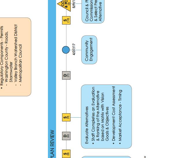
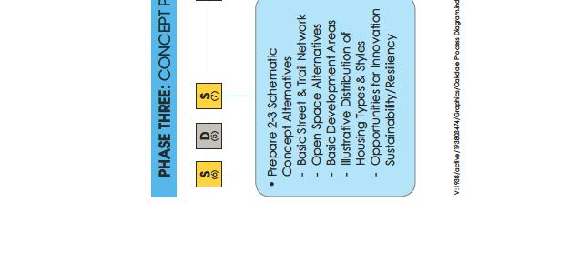
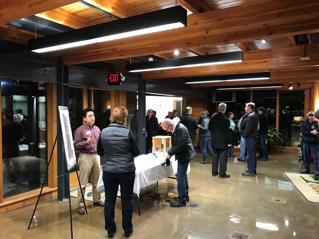
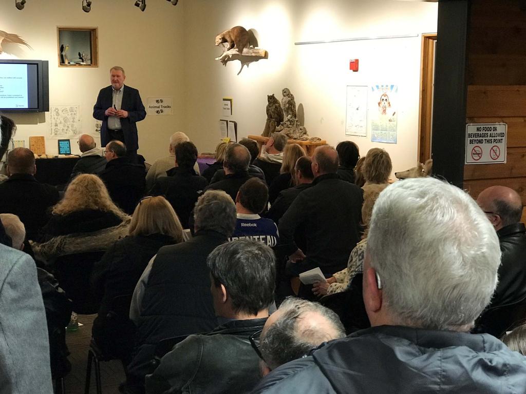
2 Because of the significant land use change, the new plan requires changing the Comprehensive Plan land use designation and rezoning to PUD; developing new infrastructure plans; determining the types and density of residential and commercial uses; and ensuring successful integration with the surrounding residential neighborhoods and the Slumberland campus. To that end, the Council authorized contracts with Stantec and Maplewood Development to complete a master planning process. Maplewood Development is paying for the master planning process. 24 January 2017 (Council Work Session): Stantec, the project consultant, and staff facilitated a discussion with the Council and Planning Commission regarding the goals for the development. Recall, that the final development concept or sketch plan will reflect the goals established by the Council. To assist the Council in identifying expectations and key goals for the project, the Council was asked to provide feedback on the following questions: 1. What are the most important issues you believe the plan ought to address? 2. If this process is successful, what will be the key outcomes? Please describe this future Oakdale neighborhood? What are its characteristics? What distinguishes it from other neighborhoods and surrounding communities? What makes it a great neighborhood? 3. What expectations do you have regarding the process? The Council s comments were summarized in Attachment B in the area colored Gold. 31 January 2017 (Neighborhood Meeting): Stantec and staff facilitated a public meeting with specific invitations to the residents to the north of the 3M site. At the meeting the consultant provided a 30 minute presentation regarding the history of the site, the small area planning process and the role for the residents in the process. Furthermore, the meeting participants were asked to respond to the same questions presented to the Council at their 24 January worksession. The participant s feedback in summarized in Attachment B in the area colored green. 14 MARCH 2017 CITY COUNCIL WORK SESSION The purpose of the work session is to have the Council approve a set of goals that will be used to shape and inform the sketch plan options which is the next phase in the small area planning process. To assist the Council, staff has provided a summary of Council and public participant feedback (Attachment B) and a draft set of goals that reflect all of the feedback received (Attachment C). It is important to note that all of the feedback was summarized into a set of themes, and it is from these themes that the draft goals are developed. This means goals are developed to reflect broader important themes, and not drafted to reflect each comment received. At the work session, John Shardlow of Stantec, will review the feedback with Council, specifically, how the themes were used to develop the draft goals. The questions for the Council to consider are: Do the draft goals accurately capture the Council s thinking? Does the Council have any modification to the goals? 2
3 Attachments: Attachment A Small Area Planning Process Attachment B Council and Public Project Feedback Attachment C Draft Goals 3
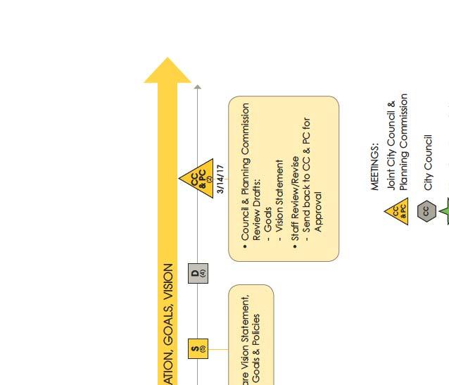
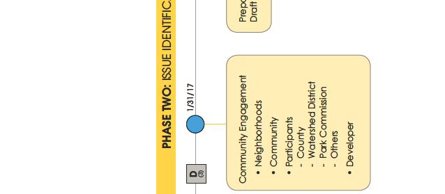
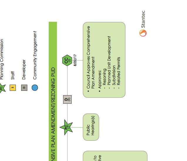
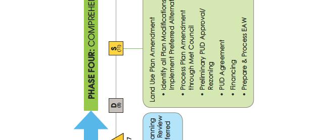
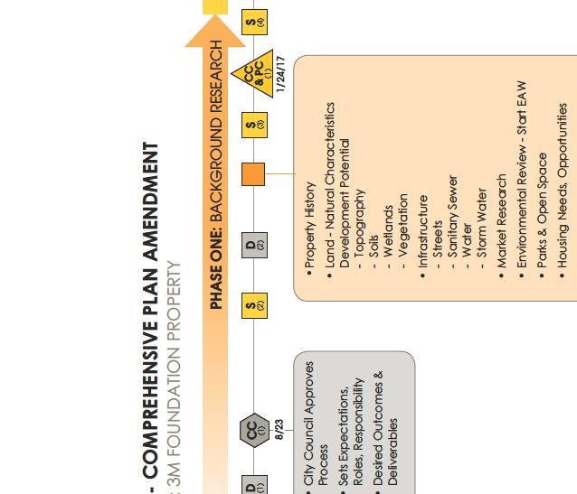

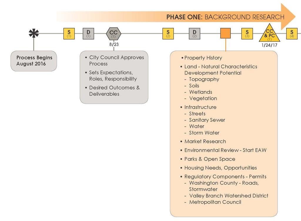
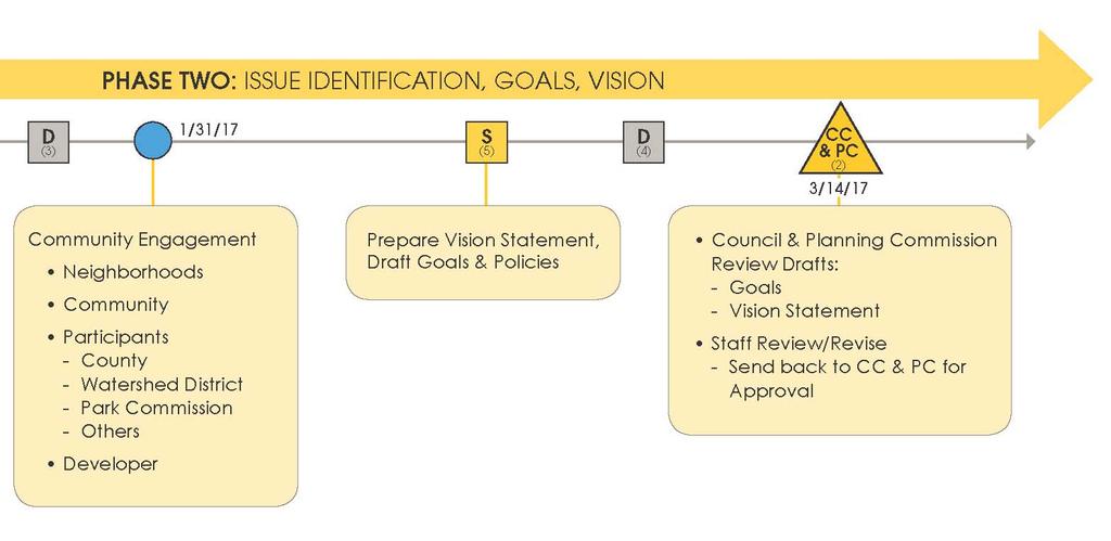
4 ATTACHMENT A
5 3M Small Area Study Public Comments LAND DEVELOPMENT OPPORTUNITIES Suitable density, function CONNECTIONS: ROADS, TRAILS, TRANSIT Community access/walkability community destinations within the neighborhood CITY COUNCIL AND PLANNING COMMISSION Increase tax base Don't overbuild maintenance Environmental impact maintain greenspace (not super crowded with buildings) Work with pipelines pipelines are a constraint for development, but can be used as an amenity trails, etc. Higher end housing rental and owner occupied; address the needs in Oakdale for higher end single and multi family homes; provide variety in housing type, but be higher end Variety of housing types Move up housing Townhouses transition on south end buffer/transition to jobs area Not cookie cutter Large lots and homes appropriately sized for the lots Access, traffic (provide access; address traffic) Sidewalks are really important; don't leave them out of development Buffer between new neighborhood and existing neighborhood to the north (keep existing fence near Sunburrow; use a berm near Heather Ridge) Low traffic (use speed bumps) Access to 40th Street Start with section south of 40th first Traffic on Helmo is too fast; need to do traffic calming especially if the road opens to the south 1 2 acre lots for homes Slow down traffic on 40th Street NEIGHBORHOOD AND COMMUNITY Oakdale does not have a town center make this a "town center" Pay attention to natural watershed (problems arise when sump pumps are needed and the power goes out = flooded basements); ensure that water is not routed to existing homes creating issues No commercial development north of 40th Street Limit number of lots Housing instead of businesses Consider existing topography Don't build houses right up to the freeway A grocery store is needed since Target downsized their selection; small retail area (coffee shop; tap room; fast casual restaurants) Affordable for young families Keep format like Olson Lake Estates and Oak Marsh developments (Oakdale has enough entry level housing) High end housing No apartments or multi family Establish minimum home values Multi generational housing Single level homes Not just one house after the other with no interest Not like Woodbury with 3,500sf homes on small lots (homes "on top of one another"); no McMansions where people don't interact with their neighbors Not overpriced like Woodbury Homes should be affordable for someone looking to sell their first home or step up into their 2nd home (around $220K not $ K+) Variety of homes; not all one style Mid cost single family homes Fewer homes and more open space. Target Property was promised shopping option for us still not complete. Houses not built next to highway Some restaurants, maybe fast casusal choices Large lots north of 40th St; mixed use, multi family and commercial south of 40th only Larger homes Address off set intersections near 40th Street (is unsafe) More walking and bike paths Connections to Gateway Trail Incorporate sustainable plantings between street and paths Address traffic speeds on streets that go through neighborhoods Do not put a thru street along Helmo. We do not need increased traffic speeding through the neighborhood where we walk. How many sidewalks do we need? Change 40th St to have a few curves. Slow traffic, especially where it ends at Ideal Ave. Change 3 "Ts" to a real intersection. NO through streets ATTACHMENT B
6 3M Small Area Study Public Comments CITY COUNCIL AND PLANNING COMMISSION NEIGHBORHOOD PARKS, NATURAL RESOURCES, AMENITIES PLANNING PROCESS It is not another Woodbury; unique distinct character Open spaces & trails, sidewalks place to walk dogs; parks in the neighborhood Maintain a high level of citizen satisfaction Not exclusive inclusive; allow it to be part of the city as a whole; welcoming; not All season planning summer and winter activities Move while the market is ripe Elements that tie it together cohesive image and character; utilize landscape themes & architectural styles throughout like at 10th Street and Oakdale Village that Community gathering space community building/pool/splash pad a citywide amenity can get there via sidewalks are unique to the neighborhood Maximize benefits/minimize unintended consequenses Successful retail Amenity corridor park/waterway/trails through the center Developer will incorporate the City Council's vision Plenty of notice for input meetings Maximizing consumer needs and wants Open communication; transparency Feedback from the neighborhood, but city wide vision Move quickly to take advantage of market conditions Create a mutually beneficial master plan (no winners/losers) NEIGHBORHOOD AND COMMUNITY Oakdale has a reputation for "cheap"; need to step it up with nice single family homes No need for retail; Target area still has room for development Create a sense of a connected community Walkable area; destinations within walking distance Match existing neighborhood with large lots, a neighborhood park, and affordable single family homes Space for wildlife; preserve existing wildlife corridors Off leash dog park that is a good size (5 10 acres); possibly by the MnDOT storm pond or at Helmo Baseball, softball, soccer fields, tennis courts, bocce ball, hockey rink, pickle ball, pool, splash pad Keep existing trees (large oaks) Need parks and nature areas with walking trails Fix the ugly chain link fence along 50th St. Playground with play equipment Keep existing fence between OLE and Sienbarrow and this new development Retain wild areas for exploration and adventure play Make this a "town center" Preserve the wildlife corridor Will the fence be removed? Concern with watter accumulation and poor runoff in our yard [43rd St. N] Would there be a burm to separate existing and new homes? Focus on sustainability and environmentally friendly development. Pay attention to natural watershed. Property on Helmo Ave N has water problesm and flooding. Consider swampy wet area in 3M property to prevent water problems in our yards [43rd Ave and Helmo] Concerned that you will not take our comments into consideration. It seems there is a plan in mind and what residents say will not be considered. A new neighborhood will be great for this land. Needs to be the pride of the city Enjoy wildlife in our backyard deer, fox, owls, turkeys Large park for biking and hiking ATTACHMENT B
7 DRAFT 3M FOUNDATION PROPERTY SMALL AREA PLAN GOALS GENERAL GOALS 1. To conduct an effective and organized planning process that includes timely opportunities for the participation of all stakeholders and supports the City Council s decision making at every project milestone. 2. Take full advantage of the opportunity to masterplan this large property to build the City s tax base and create an attractive, cohesive neighborhood, efficiently served by public infrastructure and enhanced by an interconnected, multi-purpose open space system. LAND USE 1. Realize the opportunity to reimagine the City s preferred land uses on this property and re-guide the land use designations to reflect this new vision. 2. Achieve a successfully integrated mixture of land uses that responds to market opportunities and takes full advantage of the property s potential. HOUSING 1. Provide a variety of housing choices, types, styles, and price points to serve current and future residents needs and preferences at different stages of their life cycle, with an emphasis on market supported move up housing. 2. Select housing products that support Oakdale s economic development opportunities with an eye towards the future expansion of the Slumberland campus. TRANSPORTATION 1. Design and build a network of roadways and trails,, to create a multi-modal transportation system with connections to parks, the gateway trail, employment and shopping opportunities.. 2. Emphasize accessibility for people of all ages and abilities. 3. Fully support pedestrian and bicycle infrastructure to promote active and healthy living. PARKS, OPEN SPACE AND AMENITIES 1. Create and maintain an integrated system of active and passive recreation spaces 2. Conserve, restore and augment natural resources, including native and indigenous trees and grasses to support wildlife habitat, clean air, and water quality. 3. Explore the opportunities for innovative natural resource based storm water management SUSTAINABILITY & RESILIENCY 1. Promote inclusivity and fairness in all land use, housing, and transportation decision-making 2. Plan infrastructure to promote resilience and sustainability 3. Promote healthy living, locally grown food, clean energy, air and water quality ATTACHMENT C
8 3M SPECIAL AREA STUDY Joint City Council/Planning Commission Work Session March 14, 2017
9 Agenda 1 Introduction Where are we in the Process? 2 Quick recap of the work to date 3 Objectives for this workshop 4 Summary of Council, Planning Commission and community input
10 Agenda 5 Presentation of recommended goals 6 Discussion 7 Next Steps


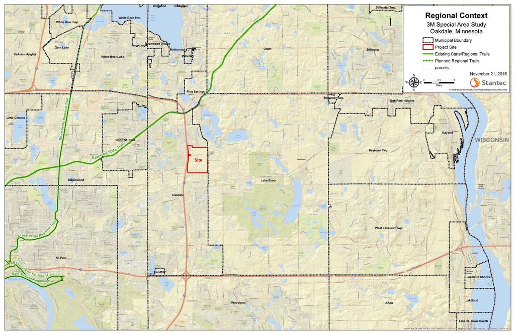
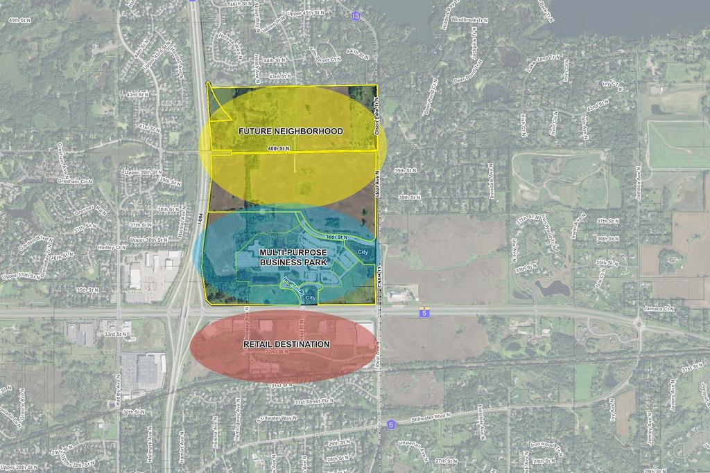
11 About the Project 3M Foundation is selling the subject property Previously part of the Imation Campus, the land is guided Multi-use Business Park and is zoned PUD (Multi-use Business Park)
12
13 1975: Original Site Design

14 1996: Modified Plans Prior to 1996, 3M abandons their expansion plans 3M sells southern half (208 acres) of the site to Imation, who constructs a new building in 1997 Plan was modified to accommodate a 1,800,000 sf. of multi-use business park

15 Tartan Crossing
16 Phase One
17 Phase Two

18 Phase Three

19 Phase Four
20 City Council 1. Authorize the process 2. Set expectations 3. Make key decisions at every project threshold
21 Planning Commission 1. Support the City Council 2. Provide feedback throughout the process on issues, goals and policies, and plan alternatives 3. Assist the Council in making decisions
22 Community and Neighbors 1. Provide feedback throughout the process on issues, goals and policies, and plan alternatives


23 What to Expect The new development framework will include: DIVERSE HOUSING OPTIONS EFFICIENT INFRASTRUCTURE SUSTAINABILITY & HEALTHY LIVING GROUNDED IN MARKET REALITY
24
25

26 Single-family listings have been declining since the beginning of 2015, with inventory ranging from a low of 6,649 to a high of 14,205, while annual pending transactions increased from 37,232 to 44,790. Downward trend in listings Upward trend in sales New construction units have accounted for eight percent to nine percent of total single-family annual sales since January 2015

27 TCM housing starts peaked at 10,500 in 4QTR 2005 and bottomed at 2,542 starts in 2QTR 2012 The 3M CMA peaked at 161 starts and bottomed at 37 new home starts Current housing starts are about 50% of the peak Current housing starts are about 80% of the peak
 below 24 months indicates a demand for new")
28 A supply of vacant developed lots (VDL) above 24 months indicates an over supply of developed lots and caution for new development A month supply of vacant developed lots (VDL) below 24 months indicates a demand for new development

29 Regional apartment vacancy rates remain very low. Regional office space has high vacancy rates and negative absorption Retail development opportunities are limited
30
31
32 City Council Expectations: Open, transparent process, clear communication throughout Respect for input from immediate neighbors, but City-wide input and vision Understand market conditions and opportunities Expect the Developer to understand and promote the City s vision and goals Take full advantage of this opportunity
33 City Council Expectations: Develop in accordance with a master plan that incorporates open spaces, trails, amenities and community parks and potentially gathering places Some move-up housing, but also offer housing choices with design elements that create a cohesive image and character Not cookie cutter Strong focus on environmental stewardship, sustainability and healthy living


34 1975: Original Site Design
35
36
37 Community Input Themes
38 Planning Process Transparency City-wide vision Take advantage of market conditions No winners/losers find mutual benefits Developer incorporates City s vision
39 Land Use Maintain green space Compatibility with adjacent single-family homes Provide mixture of housing types, styles, and price points not Woodbury Mixed opinions on retail
40 Roads, Trails, Transit Speeds on Helmo Ave. too fast More walking and bike paths Connections to other trails and sidewalks Slow traffic on 40 th Street
41 Neighborhood Unique, distinct character Part of city as a whole; welcoming Fix ugly chain link fence Be the pride of the city
42 Parks, Natural Resources, Amenities Places to walk dogs and large dog park Preserve wildlife and green space corridors Address localized flooding near wetlands Places to hike and bike

43 Draft Goals
44 General Goals: Take full advantage of the opportunity to masterplan this large property to build the City s tax base and create an attractive, cohesive neighborhood, efficiently served by public infrastructure and enhanced by an interconnected, multi-purpose open space system. To conduct an effective and organized planning process that includes timely opportunities for the participation of all stakeholders and supports the City Council s decision making at every project milestone.
45 Land Use Realize the opportunity to reimagine the City s preferred land uses on this property and re-guide the land use designations to reflect this new vision. Achieve a successfully integrated mixture of land uses that responds to market opportunities and takes full advantage of the property s potential.
46 Housing Provide a variety of housing choices, types, styles, and price points to serve current and future residents needs and preferences at different stages of their life cycle, with an emphasis on market supported move up housing. Select housing products that support Oakdale s economic development opportunities with an eye towards the future expansion of the Slumberland campus.
47 Transportation Design and build a network of roadways and trails to create a multi-modal transportation system with connections to parks, the Gateway Trail, employment and shopping opportunities. Emphasize accessibility for people of all ages and abilities. Fully support pedestrian and bicycle infrastructure to promote active and healthy living.
48 Parks, Open Space and Amenities Create and maintain an integrated system of active and passive recreation spaces Conserve, restore and augment natural resources, including native and indigenous trees and grasses to support wildlife habitat, clean air, and water quality. Explore the opportunities for innovative natural resource based storm water management.
49 Sustainability and Resiliency Promote inclusivity and fairness in all land use, housing, and transportation decision-making. Plan infrastructure to promote resilience and sustainability. Promote healthy living, locally grown food, clean energy, air and water quality.
50 QUESTIONS/DISCUSSION?
51 Attendance OAKDALE CITY COUNCIL WORKSHOP March pm The City Council held a workshop on Tuesday, March 14, 2017, at Oakdale Municipal Building, 1584 Hadley Avenue North, Oakdale, Minnesota. Present: Councilmembers: Absent: Also Present: Mayor Paul Reinke Kristen Cici Bill Rasmussen Kevin Zabel Councilmember Lori Pulkrabek Brian Bachmeier, Public Works Director / City Engineer Susan Barry, City Clerk Bart Fischer, City Administrator Jim Thomson, City Attorney Meeting with Washington County Commissioner Karwoski County Commissioner Karwoski and the City Council discussed the Gateway Corridor, the dissolution of the County Transit Improvement Board, the proposed 94 / 494 / 694 interchange project, and the proposed Highway 36 and Hadley Avenue overpass project. Special Election The City Council discussed whether to hold the special election for the mayor s seat and Councilmember Cici s seat at the August 14, 2018 State Primary or the November 6, 2018 General Election. Councilmember Zabel supported holding off on making a decision until an opinion is provided by the attorney general s office on the filing for office process. The City Council inquired about the wording on the ballot and whether there could be any movement to the filing periods. The City Council also discussed filling the vacancy on the City Council and whether to appoint the next-highest vote getter or to take applications from the general public. Staff was directed to bring the matter back for discussion at the March 28 workshop. 3M Small Area Study Also Present: Jake Ingebrigtson, Planning Commission Chair Corey Purkat, Planning Commissioner Mark Skjerven, Planning Commissioner Lee Stolarski, Planning Commissioner Mario Cocchiarella, Maplewood Development, Inc. Tim Mannie, Maplewood Development, Inc. John Shardlow, Stantec, Senior Principal Faith Simer, Stantec, Senior Planner Chuck Wicklund, Alliant, Engineer
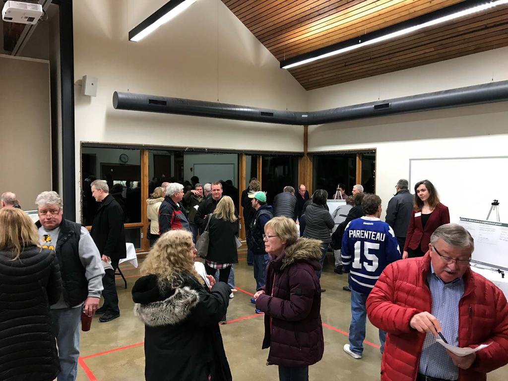
52 Workshop March Page Two Bob Streetar, Community Development Director Emily Graffunder-Bartels, Senior Community Development Specialist Jen Hassebroek, Senior Community Development Specialist Emily Shively, City Planner John Shardlow, Stantec, reported back on the development goals and neighborhood characteristics identified at the January 24 workshop relating to the development of the 206-acre site located north of the Slumberland campus. He reviewed: general goals as well as land use; housing; transportation; parks, open space, and amenities; and sustainability and resiliency. Faith Simer, Stantec, provided an overview of the comments shared by residents at the neighborhood meeting. In response to a request from Mayor Reinke, Mr. Shardlow noted that he would bring back examples of developments comparable to that to be proposed. Planning Commissioner Skjerven noted that residents in the area have expressed concern with increased traffic volumes once the site develops and also commented on the need to complete the retail development south of the Slumberland campus. In discussing the natural gas pipelines on the site, Planning Commission Chairperson Ingebrigtson suggested that developing trails over the pipelines would be a good utilization of the easements. Mario Cocchiarella, developer, shared how neighborhoods and housing designs have changed since 2000 and that the proposed project would be different from any other developments in the city. He added that there would be a variety of housing types that would appeal to all ages. Mr. Shardlow noted that the placement of parks and open space would help determine the placement of the housing. Mayor Reinke appreciated the developer s willingness to work with the city on the small area study process. Councilmember Rasmussen asked that the homes be spaced out. Commissioner Skjerven agreed. He also asked for no-maintenance green space. Councilmember Cici noted that offering a mix of home styles and lot sizes would meet all needs. Councilmember Rasmussen also asked that the development include sidewalks. Mr. Shardlow asked that any additional comments be submitted to City Planner Shively. Adjournment The meeting adjourned at 6:46 pm.
OPEN HOUSE. Future. Neighborhood. Thursday April 27, :30 8:30 PM Refreshments provided Discovery Center, 4444 Hadley Avenue North
 OPEN HOUSE Thursday April 27, 2017 6:30 8:30 PM Refreshments provided Discovery Center, 4444 Hadley Avenue North The City Council has ini ated a planning process to guide future development on 206 acres
Gold Line Bus Rapid Transit Transit Oriented Development (BRTOD) Helmo Station Area Plan
 Helmo Station Area Plan") Appendix F Gold Line Bus Rapid Transit Transit Oriented Development (BRTOD) Helmo Station Area Plan Introduction and Purpose of the Plan The Gold Line Bus Rapid Transit facility is an eleven-mile dedicated
Appendix F Gold Line Bus Rapid Transit Transit Oriented Development (BRTOD) Helmo Station Area Plan Introduction and Purpose of the Plan The Gold Line Bus Rapid Transit facility is an eleven-mile dedicated
Further input invited as Colchester Growth Strategy nears final phase
 IUE 3 / NOVEMBER 2015 Further input invited as Colchester Growth trategy nears final phase trathcona County is seeking public feedback as it enters the final phase of work on a Growth Management trategy
Lehigh Acres Land Development Regulations Community Planning Project
 Lehigh Acres Land Development Regulations Planning Effort Summary In July, 2010 Commissioner Frank Mann invited the Lehigh Acres community to start discussing how to achieve their recently adopted community
Town Center (part of the Comprehensive Plan)
") Town Center (part of the Comprehensive Plan) Mercer Island Town Center Looking North (2014) In 1994, a year-long process culminated in a set of design guidelines and code requirements for the Town Center
Town Center (part of the Comprehensive Plan) Mercer Island Town Center Looking North (2014) In 1994, a year-long process culminated in a set of design guidelines and code requirements for the Town Center
A BLUEPRINT FOR BROCKTON A CITY-WIDE COMPREHENSIVE PLAN
 A BLUEPRINT FOR BROCKTON A CITY-WIDE COMPREHENSIVE PLAN Public Meeting October 2016 1 Plan Summary and Discussion Public Meeting May 4 2017 City of Brockton Bill Carpenter, Mayor Department of Planning
Clair-Maltby Community visioning
 Clair-Maltby Community visioning workshop #1 Summary April 27th, 2017 Table of Contents INTRODUCTIon 1 PURPOSE 1 CONSULTATION STRUCTURE 2 PARTICIPANT FEEDBACK 3 VISIONING EXERCISE 8 ONLINE SURVEY RESULTS
Port Lavaca Future Land Use
 Port Lavaca Future Land Use Introduction The City of Port Lavaca is beginning to see sustained growth, after many years of relative stable population. New single family homes, apartments, and businesses
The Cambie Corridor 2015 Fall workshop series. What we heard WORKSHOP OUTLINE
 The Cambie Corridor 2015 Fall workshop series W 16 AVE Area 5 CAMBIE CORRIDOR Phase 3 What we heard ovember 21, 2015, 9am-noon, 1:30-4:30pm Peretz Centre 89 Participants* WORKSHOP OUTLIE Introductions
In surveys, Dallas residents say what they want to change most
 NEIGHBORHOODS ELEMENT In surveys, Dallas residents say what they want to change most in the city is its appearance they want it to look beautiful, with trees and pedestrian-friendly neighborhoods. The
The Five Components of the McLoughlin Area Plan
 The Five Components of the McLoughlin Area Plan This documents contains the complete language of the five components of the McLoughlin Area Plan: The Vision Statement The Values The Guiding Principles
Urban Planning and Land Use
 Urban Planning and Land Use 701 North 7 th Street, Room 423 Phone: (913) 573-5750 Kansas City, Kansas 66101 Fax: (913) 573-5796 Email: planninginfo@wycokck.org www.wycokck.org/planning To: From: City Planning
1 Welcome! UBC Okanagan Master Plan Update - Open House
 1 Welcome! UBC Okanagan Master Plan Update - Open House UBC is updating the Master Plan for the Okanagan Campus. The purpose of today s Open House is to: Present the draft 2015 Master Plan Answer any questions
Whitemarsh Comprehensive Plan Update: Housing & Land Use. Public Workshop #3: September 20, 2018
 Whitemarsh Comprehensive Plan Update: Housing & Land Use Public Workshop #3: September 20, 2018 Agenda Welcome Process Recap What We ve Heard The Plan Framework Review of Recommended Actions Land Use Housing
Small Area Plan. South Gateway
 Small Area Plan Adopted May 12, 2008 South Gateway Purpose. The South Gateway Small Area Plan defines the City s expectations for the future of the southern entrance to the City at Interstate 85 and Highway
DOMINION BOULEVARD CORRIDOR STUDY AND ECONOMIC DEVELOPMENT STRATEGIC PLAN A MODEL FOR CHESAPEAKE S FUTURE
 DOMINION BOULEVARD CORRIDOR STUDY AND ECONOMIC DEVELOPMENT STRATEGIC PLAN A MODEL FOR CHESAPEAKE S FUTURE Overview I. Draft Plan Process II. Draft Plan Overview a. Market Analysis b. Master Land Use Plan
WHAT WE HEARD REPORT - Summary Bonnie Doon Mall Redevelopment Application (LDA )
") WHAT WE HEARD REPORT - Summary Bonnie Doon Mall Redevelopment Application (LDA18-0184) PROJECT ADDRESS: 1 Bonnie Doon Shopping Centre NW, 8420 85 Street NW & 8715 85 Street NW PROJECT DESCRIPTION: Rezoning
WHAT WE HEARD REPORT - Summary Bonnie Doon Mall Redevelopment Application (LDA18-0184) PROJECT ADDRESS: 1 Bonnie Doon Shopping Centre NW, 8420 85 Street NW & 8715 85 Street NW PROJECT DESCRIPTION: Rezoning
MEMO 1. INTRODUCTION PURPOSE & PROCESS REQUEST
 MEMO Date: August 22, 2017 To: Board of Commissioners From: Jason Burdette, Planning Director Re: Davidson Commons East Hotel Stakeholder Feedback 1. INTRODUCTION PURPOSE & PROCESS This memorandum summarizes
PROJECT BACKGROUND. Preliminary Design Scope and Tasks
 PROJECT BACKGROUND Preliminary Design Scope and Tasks The purpose of this Study is the development of preliminary designs for intersection improvements for Trunk Highway (TH) 36 at the intersections of
EXECUTIVE SUMMARY DRAFT CHAPTER 1 INTRODUCTION EXECUTIVE SUMMARY
 CHAPTER 1 EXECUTIVE SUMMARY INTRODUCTION Through the joint efforts of the City of Tulsa planning staff and the Land Services division of Indian Nations Council of Governments (INCOG), the Berryhill Land
DALY CITY VISIONING PROCESS COMMUNITY WORKSHOP 3 MAY 8, 2008
 DALY CITY VISIONING PROCESS COMMUNITY WORKSHOP 3 MAY 8, 2008 PROCESS General Plan - a statement of the community s values, vision and aspirations for now and into the future... Timeframe LONG TERM - 2030
AVONDALE ESTATES GREENSPACE AD-HOC COMMITTEE
 AVONDALE ESTATES GREENSPACE AD-HOC COMMITTEE INVENTORY AND RECOMMENDATIONS REPORT November 7, 2018 Our Mission Statement: To provide assistance and support, through professional expertise in matters of
This Review Is Divided Into Two Phases:
 Semiahmoo Town Centre Review The purpose of this review: To review the Semiahmoo Town Centre Concept Plan, originally approved in 1993, to ensure that this centre will continue to serve the needs of South
North Fair Oaks Community Plan Summary and Information
 North Fair Oaks Community Plan Summary and Information WHAT IS THE NORTH FAIR OAKS COMMUNITY PLAN? The North Fair Oaks Community Plan is part of the San Mateo County General Plan, and establishes policies
CONSENT CALENDAR CITY PLANNING COMMISSION AGENDA ITEM NO: A.1, A.2 STAFF: LARRY LARSEN
 Page 8 CONSENT CALENDAR CITY PLANNING COMMISSION AGENDA ITEM NO: A.1, A.2 STAFF: LARRY LARSEN FILE NO: CPC PUZ 14-00013 - QUASI-JUDICIAL FILE NO: CPC PUD 14-00014 QUASI-JUDICIAL PROJECT: APPLICANT: OWNER:
MEETING PURPOSE AND OVERVIEW
 MEETING PURPOSE AND OVERVIEW On February 23, 2012, the City of Elk Grove hosted the first of two community workshops related to the Southeast Policy Area. The workshop was held from 6:00 8:30 p.m. in the
Colchester Growth Management Strategy. Open House Meeting October 1, 2015
 Colchester Growth Management Strategy Open House Meeting October 1, 2015 6:00 View panels and meet the consultant team 6:30 Presentation and Q&A 7:30 Informal discussion and fill out comment sheets The
Broken Arrow Comprehensive Plan Update Public Workshop Meeting #3 January 23,
 Broken Arrow Comprehensive Plan Update Public Workshop Meeting #3 January 23, September 25,2018 2018 26 April 2016 AGENDA 1. Status Presentation - Charrette Recap - Proposed Vision Framework - Preliminary
PLAN ELEMENTS WORKSHOP. April 5, 2016
 PLAN ELEMENTS WORKSHOP April 5, 2016 needs more housing. But there is no one-size fits-all solution. Every neighborhood has its own character. In some places, density is not only appropriate it is badly
Introduction. Chapter 1. Purpose of the Comprehensive Plan Plan Organization Planning Process & Community Input 1-1
 Chapter 1 Introduction Lakewood 2025: Moving Forward Together Purpose of the Comprehensive Plan Plan Organization Planning Process & Community Input 1-1 Purpose of the Comprehensive Plan The Comprehensive
Don Mills Crossing Study and Celestica Lands Development Application Community Meeting, Open House, and Breakout Discussions
 Consultation Summary Don Mills Crossing Study and Celestica Lands Development Application Community Meeting, Open House, and Breakout Discussions This report is not intended to provide a verbatim transcript
Concord Community Reuse Project Goals and Guiding Principles. Overarching Goals (OG)
") Concord Community Reuse Project Goals and Guiding Principles Overarching Goals (OG) No priority is implied by the order of presentation of the goals and guiding principles. Overarching goals for the Concord
Concord Community Reuse Project Goals and Guiding Principles Overarching Goals (OG) No priority is implied by the order of presentation of the goals and guiding principles. Overarching goals for the Concord
ELK GROVE GENERAL PLAN VISION
 2-1 CHAPTER 2: 2-2 CREATING OUR The Community Vision for Elk Grove, expressed through a Vision Statement and a series of Supporting Principles, is a declaration of the kind of community that Elk Grove
Sahuarita District & Phase 1 Master Plan. Town Council December 11, 2017
 Sahuarita District & Phase 1 Master Plan Town Council December 11, 2017 Visioning Study Visioning Process Advisory Group Meetings Community Questionnaire Town Center Case Studies Community Analysis The
BROOKHILL NEIGHBORHOOD MODEL ZONING MAP AMENDMENT PREFACE TO APPLICATION
 BROOKHILL NEIGHBORHOOD MODEL ZONING MAP AMENDMENT PREFACE TO APPLICATION June 15, 2015 Revised: August 1, 2016 I. VISION Brookhill is a proposed community based upon the principles of Albemarle County
Ten Mile Creek Planning Area
 PLANNING AREA POLICIES TEN MILE CREEK Ten Mile Creek Planning Area Location and Context The Ten Mile Creek Planning Area ( Ten Mile Creek area ) is located south of the current Boise AOCI, generally south
Municipal Plan*Assessment
 Municipal Plan*Assessment This tool was developed to assist in reviewing municipal master plans and in determining if these plans are consistent with smart growth principles, neighboring municipal plans,
The Plan for Port Whitby
 The Plan for Port Whitby December 5, 2012 Community Meeting Summary Report Prepared by GLPi January 17, 2013 1 Introduction The purpose of the Port Whitby Secondary Plan Update, Community Improvement Plan
OVERVIEW OF PLANS FOR THE JEFFERSON COUNTY COUNTRYSIDE FARM In the Context of Quality Place Characteristics
 OVERVIEW OF PLANS FOR THE JEFFERSON COUNTY COUNTRYSIDE FARM In the Context of Quality Place Characteristics By Steve Grabow, Professor and Community Development Educator University of Wisconsin-Extension,
East Central Area Plan
 East Central Area Plan Steering Committee Meeting January 10 th, 2019 Tears-McFarlane House Community Room East Central Area Plan Steering Committee Meeting January 10 th, 2019 CHUN Tears-McFarlane House
Public Meeting Final Recommendations August 8, 2013
 Public Meeting Final Recommendations August 8, 2013 Meeting Agenda 1. Existing Conditions 2. Plan Building Blocks & Process 3. The Plan Policies 4. What we heard 5. Next Steps Existing Conditions Existing
1.0 Purpose of a Secondary Plan for the Masonville Transit Village
 Report to Planning and Environment Committee To: Chair and Members Planning & Environment Committee From: John M. Fleming Managing Director, Planning and City Planner Subject: Masonville Transit Village
S A C R A M E N T O C O U N T Y JACKSON HIGHWAY & GRANT LINE EAST VISIONING STUDY
 JACKSON HIGHWAY & GRANT LINE EAST S A C R A M E N T O C O U N T Y P L A N N I N G D E P A R T M E N T SUMMARY AND WORKBOOK November 19, 2008 History of the Visioning Study Sacramento County has two growth
CHAPTER 7: Transportation, Mobility and Circulation
 AGLE AREA COMMUNITY Plan CHAPTER 7 CHAPTER 7: Transportation, Mobility and Circulation Transportation, Mobility and Circulation The purpose of the Transportation, Mobility and Circulation Chapter is to
Implementation Guide Comprehensive Plan City of Allen
 Implementation Guide 2030 Comprehensive Plan City of Allen DRAFT 2015 Implementation Guide Allen 2030 Comprehensive Plan INTRODUCTION The Comprehensive Plan serves as a guide for the growth and development
Planning Board Briefing
 Planning Board Briefing Why Now? The Sector Plan Implementation Chapter States: Before Stage 1 begins, the following must occur: Approval of the Sectional Map Amendment. Approval of the Greater Lyttonsville
Design Fort Ord. welcome why we are here what happened this week design guidelines: ideas so far 2/12/2015. Regional Urban Design Guidelines (RUDG)
") Design Fort Ord Regional Urban Design Guidelines (RUDG) Welcome Back! Strategic Economics Alta Planning + Design National Charrette Institute Helix Environmental Planning Jeff Speck & Peter Katz Civitas
Design Fort Ord Regional Urban Design Guidelines (RUDG) Welcome Back! Strategic Economics Alta Planning + Design National Charrette Institute Helix Environmental Planning Jeff Speck & Peter Katz Civitas
City Council March 27, Parks, Recreation, and Trails Master Plan
 City Council March 27, 2018 Parks, Recreation, and Trails Master Plan Planning Process Develop Goals and Objectives Inventory of Areas and Facilities Needs Assessment And Identification Public Participation
WARM SPRINGS PARK MASTER PLAN
 TABLE OF CONTENTS page 1.0 Introduction and Overview 1 2.0 Information Gathering 2 3.0 Conceptual Alternative Development 8 4.0 Master Plan Development 14 5.0 Construction Cost Estimates 19 LIST OF FIGURES
Courthouse Square Planning & Urban Design Study. Courthouse Square Working Group #13 October 15, 2014
 Courthouse Square Planning & Urban Design Study Courthouse Square Working Group #13 October 15, 2014 1 Courthouse Square Process Working Group Community Courthouse Square Advisory Groups & Civic Associations
Complete Neighbourhood Guidelines Review Tool
 Complete Neighbourhood Guidelines Review Tool Prepared By: City of Regina Planning Department October 2014 Page 1 of 14 Community Development Review Checklist for Secondary Plans and Concept Plans The
CITY OF UNION CITY MINUTES GENERAL PLAN ADVISORY COMMITTEE
 CITY OF UNION CITY MINUTES GENERAL PLAN ADVISORY COMMITTEE WEDNESDAY, MARCH 4, 2015, 6:30 P.M. IN THE CITY COUNCIL CONFERENCE ROOM OF CITY HALL 34009 ALVARADO-NILES BLVD., UNION CITY, CALIFORNIA Attachment
12 AMENDMENT NO. 149, TOWN OF MARKHAM HIGHWAY 404 NORTH SECONDARY PLAN
 12 AMENDMENT NO. 149, TOWN OF MARKHAM HIGHWAY 404 NORTH SECONDARY PLAN The Planning and Economic Development Committee recommends the adoption of the recommendation contained in the following report August
Westbound: A One-day Exploration of Growth
 Westbound: A One-day Exploration of Growth Frog Pond Area 2018 UGB Expansion Proposal June 13, 2018 Growing Out: UGB Asks Four cities submitted proposals to expand greater Portland s urban footprint by
GRANDVIEW HEIGHTS NCP AREA #3 CITIZEN ADVISORY COMMITTEE (CAC) MEETING #6
 MEETING #6") WELCOME TO THE NCP AREA #3 CITIZEN ADVISORY COMMITTEE (CAC) MEETING #6 For more information visit the city of surrey webpage at: www.surrey.ca/gh3ncp 1 Feb 1, 2018 CAC Meeting NEIGHBOURHOOD CONCEPT PLAN
WELCOME TO THE NCP AREA #3 CITIZEN ADVISORY COMMITTEE (CAC) MEETING #6 For more information visit the city of surrey webpage at: www.surrey.ca/gh3ncp 1 Feb 1, 2018 CAC Meeting NEIGHBOURHOOD CONCEPT PLAN
Summary Community Workshop #1 Fruitvale San Antonio Senior Center Monday, March 23, :00-9:00 p.m.
 Summary Community Workshop #1 Fruitvale San Antonio Senior Center Monday, March 23, 2009 7:00-9:00 p.m. Workshop Format and Process The City of Oakland is preparing a Specific Plan that will help define
Ridgewood Precinct Plan
 June 20, 2011 PUBLIC OPEN HOUSE - COMMENT FORM RESULTS A public open house and workshop session were held on June 20, 2011 at the Charleswood United Church at 4820 Roblin Avenue. Approximately 400-500
Town of Peru Comprehensive Plan Executive Summary
 Town of Peru Comprehensive Plan Executive Communities that plan grow by choice, not by chance. A plan makes growth thoughtful, understandable, and predictable. A plan shows that a community is managing
Neighborhood Districts
 NEIGHBORHOOD DISTRICTS SEVEN MAIN DISTRICTS Neighborhood Districts While the Development Plan provides a broad-scale overview of the neighborhood, this section focuses on uses and relationships at the
Yadkin River Greenway Feasibility Study Fact Sheet Village of Clemmons, Town of Lewisville, Town of Bermuda Run
 Fact Sheet Village of Clemmons, Town of Lewisville, Town of Bermuda Run Project Background The Yadkin River Greenway Feasibility Study is a joint project with the Village of Clemmons, the Town of Bermuda
ADOPTION OF THE REVISED OPEN SPACE AND CONSERVATION ELEMENT OF THE GENERAL PLAN
 TO: FROM: SUBJECT: Honorable Mayor and City Council Planning Department ADOPTION OF THE REVISED OPEN SPACE AND CONSERVATION ELEMENT OF THE GENERAL PLAN RECOMMENDATION: It is recommended that the City Council:
1. Parks & Recreation Neighborhood Parks Community Parks Special Use Sites 2. Open Space 3. Trails
 Appendix A: Park Classifications The intent of parks and recreation classifications is to aid in making acquisition and design decisions for park sites, facilities and the organization of recreation space
1120 Haist Street - Pelham Arena Community Co-Design Recommendation Report Haist Street - Pelham Arena Community Co-Design Recommendation Report
 1120 Haist Street - Pelham Arena Community Co-Design Executive Summary: In May, 2017 the Town retained the services of The Planning Partnership to undertake a community design charrette process to determine
3. VISION AND GOALS. Vision Statement. Goals, Objectives and Policies
 Vision Statement Queen Creek s interconnected network of parks, trails, open spaces and recreation opportunities provide safe and diverse activities and programs that sustain its unique, small town, equestrian
Summary Community Workshop #6 Beacon Day School Saturday, November 14, :00 a.m. 12:00 p.m.
 Summary Community Workshop #6 Beacon Day School Saturday, November 14, 2009 9:00 a.m. 12:00 p.m. Workshop Format and Process The City of Oakland is preparing a Specific Plan that will help define and determine
CHAPTER 7: VISION AND ACTION STATEMENTS. Noble 2025 Vision Statement
 CHAPTER 7: VISION AND ACTION STATEMENTS This chapter presents the vision, policy and action statements that transform the comprehensive planning study, an analysis of Noble s past, future trends and community
KENDALL SQUARE INITIATIVE. Planned Unit Development Special Permit Application - SoMa September 8, 2015
 KENDALL SQUARE INITIATIVE Planned Unit Development Special Permit Application - SoMa September 8, 2015 GENERAL DEVELOPMENT GOALS Kendall Square PUD 2 PRE-ZONING PUBLIC ENGAGEMENT 2008-2009 2010-2012 2013
Schedule B to Report PLS
 Page 25 Q1. The land use concept is made up of many different land uses (residential, commercial, parks, schools, environmental areas etc.) A number of land uses are concentrated in the Community Core,
The transportation system in a community is an
 7 TRANSPORTATION The transportation system in a community is an important factor contributing to the quality of life of the residents. Without a sound transportation system to bring both goods and patrons
K. SMART ASSOCIATES LIMITED
 Planning Justification Report Zoning By-Law Amendment 185 King Street North Waterloo, Ontario April 7th, 2017 Project Reference Number 16-245 K. SMART ASSOCIATES LIMITED CONSULTING ENGINEERS AND PLANNERS
MAYFIELD WEST SECONDARY PLAN PHASE 2
 MAYFIELD WEST SECONDARY PLAN PHASE 2 Public Open House #3 February 25, 2010 Draft Preferred Land Use Scenario TOWN OF CALEDON PLANNING & DEVELOPMENT DEPARTMENT Open House Agenda TOWN OF CALEDON 1. Welcome
M E E T I N G S U M M A R Y
 EXPO Maintenance Facility Buffer Zone City of Santa Monica M E E T I N G S U M M A R Y OVERVIEW On Tuesday, a was held at Virginia Avenue Park in the City of Santa Monica to provide an update on the EXPO
CITY CLERK. Parkland Acquisition Strategic Directions Report (All Wards)
") CITY CLERK Clause embodied in Report No. 10 of the, as adopted by the Council of the City of Toronto at its meeting held on November 6, 7 and 8, 2001. 10 Parkland Acquisition Strategic Directions Report
CITY CLERK Clause embodied in Report No. 10 of the, as adopted by the Council of the City of Toronto at its meeting held on November 6, 7 and 8, 2001. 10 Parkland Acquisition Strategic Directions Report
This page is intentionally blank.
 FINAL APRIL 2018 This page is intentionally blank. ACKNOWLEDGEMENTS: The Gold Line BRTOD Plans project is a partnership between Washington County, Ramsey County and the cities of Saint Paul, Maplewood,
THEMES, VISION, + PRINCIPLES
 CHAPTER 2: THEMES, VISION, + PRINCIPLES This page intentionally left blank. 20 VISION DRAFT AUGUST 2018 2 2 THEMES, VISION, + GUIDING PRINCIPLES The Key Themes, Vision, and Guiding Principles presented
December 1, 2014 (revised) Preliminary Report -- Thomas Jefferson Site Evaluation
 Preliminary Report -- Thomas Jefferson Site Evaluation") December 1, 2014 (revised) TO: FROM: RE Arlington County Board Thomas Jefferson Site Evaluation Working Group by Carrie Johnson, Chair Preliminary Report -- Thomas Jefferson Site Evaluation The Thomas
December 1, 2014 (revised) TO: FROM: RE Arlington County Board Thomas Jefferson Site Evaluation Working Group by Carrie Johnson, Chair Preliminary Report -- Thomas Jefferson Site Evaluation The Thomas
North Salt Lake General Plan Update 2013
 North Salt Lake General Plan Update 2013 Acknowledgements Updating the North Salt Lake General Plan was a process that would not have been possible without the support of elected officials and the general
Senator Sieben SF Representative Schoen HF Presentation Guide
 Senator Sieben SF 1179 Representative Schoen HF 1374 Presentation Guide Appearance Transportation and Public Safety, Room 15 of the Capitol. 3-5:30 PM on Wednesday, March 13 Speakers Honorable Senator
Master Plan Visioning #1 Section 3 Informal amphitheater at Community Development Services Building. Section 3 MP Visioning #1
 Section 3 Informal amphitheater at Community Development Services Building Section 3 MP Visioning #1 THIS PAGE INTENTIONALLY LEFT BLANK. appendix As with the master planning of any government campus, the
FOUR MILE RUN VALLEY WORKING GROUP AND CHARGE
 FOUR MILE RUN VALLEY WORKING GROUP AND CHARGE Adopted April 16, 2016 Amended July 19, 2016 Overview of Integrated Effort The overall goal of the Four Mile Run Valley (4MRV) initiative is to develop a comprehensive
TOWN OF INNISFIL SPECIAL COUNCIL AGENDA OUR JOBS INNISFIL HEIGHTS WORKSHOP WEDNESDAY JANUARY 20, :30 P.M.
 January 13, 2016 TOWN OF INNISFIL SPECIAL COUNCIL AGENDA INNISFIL HEIGHTS WORKSHOP WEDNESDAY JANUARY 20, 2016 5:30 P.M. PLEASE REMEMBER TO TURN OFF CELL PHONES 1. OPENING OF MEETING BY THE MAYOR Opening
CHAPTER 3 VISION, GOALS, & PLANNING PRINCIPLES. City of Greensburg Comprehensive Plan. Introduction. Vision Statement. Growth Management Goals.
 CHAPTER 3 VISION, GOALS, & PLANNING PRINCIPLES Introduction The Greensburg Comprehensive Plan is intended as a working community document. A combination of long and short-term goals, this document is intended
SUBJECT: Waterfront Hotel Planning Study Update TO: Planning and Development Committee FROM: Department of City Building. Recommendation: Purpose:
 Page 1 of Report PB-23-18 SUBJECT: Waterfront Hotel Planning Study Update TO: Planning and Development Committee FROM: Department of City Building Report Number: PB-23-18 Wards Affected: 2 File Numbers:
REQUEST FOR COUNCIL ACTION 6A AGENDA ITEM ORIGINATING DEPT. AGENDA ITEM CITY ADMINISTRATOR APPROVAL
 DATE REQUEST FOR COUNCIL ACTION 6A AGENDA ITEM ORIGINATING DEPT. AGENDA ITEM CITY ADMINISTRATOR APPROVAL Community Development Territorial Greens PUD Concept Plan Development Stage Plan Subdivision (Preliminary
HE VISION. Building a Better Connected Place
 HE VISION Building a Better Connected Place WALK INTO THE FUTURE. Life in Cranberry, 2030 Here s what our residents told us they wanted to see in their community by 2030: The Cranberry of 2030 is a place
Welcome to the Oakridge Centre Open House
 Welcome to the Oakridge Centre Open House Why is the City hosting this event? This open house is to inform you of a rezoning application submitted to the City of Vancouver to amend the existing CD-1 (Comprehensive
Silver Line CPAM UPDATE. Transportation and Land Use Committee October 14, 2016
 Silver Line CPAM UPDATE Transportation and Land Use Committee October 14, 2016 Purpose Recap Project History and Map Changes Provide Overview of CPAM Components Discuss Transportation Impacts Discuss Fiscal
CHAPPLES PARK MASTER PLAN. Presentation to Council April 10, 2017
 CHAPPLES PARK MASTER PLAN Presentation to Council April 10, 2017 1 PRESENTATION AGENDA 1. Project Background, Aim and Process 2. The Site Issues and Opportunities 3. Community Engagement 4. Vision and
Edward R. Sajecki Commissioner of Planning and Building
 Corporate Report Clerk s Files Originator s Files CD.03.POR DATE: TO: FROM: SUBJECT: Chair and Members of Planning and Development Committee Meeting Date: February 27, 2012 Edward R. Sajecki Commissioner
Chapter 2: Vision, Goals and Strategies
 Chapter 2: Vision, Goals and Lake Elmo Today & Tomorrow Comprehensive Plan 2040 2 VISION, GOALS & STRATEGIES - DRAFT 4-6-2018 INTRODUCTION Comprehensive Plan Purpose Perhapse the most important objective
Agincourt Mall Planning Framework Review Local Advisory Committee Meeting #1 Summary
 Agincourt Mall Planning Framework Review Local Advisory Committee Meeting #1 Summary Wednesday, December 13, 2017 7:00 9:00 p.m. Agincourt Mall, Unit 100 3850 Sheppard Avenue East This is a high level
City Council Special Meeting AGENDA ITEM NO. C.
 City Council Special Meeting AGENDA ITEM NO. C. DATE: 01/04/2019 TO: Honorable Mayor and City Council Members SUBJECT: Transit Villages Specific Plan project Study Session (Development Services Director
Planning Districts INTRODUCTION
 INTRODUCTION To facilitate detailed examination of development prospects for all areas of the community, Delano has been divided into 14 planning districts. The location of these planning districts is
TEAM INPUT SUMMARY. Postcard Image?
 DOWNTOWN MAULDIN TEAM PUBLIC INPUT TEAM INPUT SUMMARY Postcard Image? A nice neighborhood The main city center with government buildings Mauldin entry sign, high school, Cultural Center, Sunset Park, Hall
ROAD CLOSURE AND LAND USE AMENDMENT SILVER SPRINGS (WARD 1) NORTHEAST OF NOSEHILL DRIVE NW AND SILVER SPRINGS ROAD NW BYLAWS 2C2018 AND 29D2018
 NORTHEAST OF NOSEHILL DRIVE NW AND SILVER SPRINGS ROAD NW BYLAWS 2C2018 AND 29D2018") Page 1 of 19 EXECUTIVE SUMMARY This application proposes redesignating two parcels in the community of Silver Springs from Special Purpose Future Urban Development (S-FUD) District and undesignated road
Page 1 of 19 EXECUTIVE SUMMARY This application proposes redesignating two parcels in the community of Silver Springs from Special Purpose Future Urban Development (S-FUD) District and undesignated road
Envision Front Royal Workshop 1 of 2
 Envision Front Royal Workshop 1 of 2 September 12, 2013 Summary The Envision Front Royal project held the first of two public workshops on September 12, 2013. The purpose of the workshop was to evaluate
Comprehensive Plan. Faribault, Minnesota. Hoisington Koegler Group Inc. Claybaugh Preservation Architecture Inc. Howard R. Green Company Bonz/REA
 Comprehensive Plan Faribault, Minnesota Adopted by the Faribault City Council July 8, 2003 prepared for: prepared by: Hoisington Koegler Group Inc. Claybaugh Preservation Architecture Inc. Howard R. Green
3.1 community vision. 3.3 required plan elements
 Chapter 3 Community Form 3.1 community vision 3.2 Parks & landscaping concepts 3.3 required plan elements D R A F T 20 Community Form Chapter 3 3.0 Community form 3.1 community vision The Specific Plan
Joint Study Session of the Sutter County. March 2, 2009
 Joint Study Session of the Sutter County Board of Supervisors and Planning Commission March 2, 2009 CURRENT APPLICATION General Plan Amendment Specific Plan Specific Plan Appendices Utility Plans Transit/AQ
TOWN OF BETHLEHEM MEETING SUMMARY LOCAL WATERFRONT REVITALIZATION PROGRAM UPDATE
 TOWN OF BETHLEHEM LOCAL WATERFRONT REVITALIZATION PROGRAM UPDATE MEETING SUMMARY Purpose: LWRP Update Public Workshop #3 Date and Time: October 24, 2017, 6:00 pm - 8:00 pm Location: Town Hall, 445 Delaware