Technical Report Land Use Plan Compatibility
|
|
|
- Harriet Curtis
- 5 years ago
- Views:
Transcription
1 Technical Report Land Use Plan Compatibility 1.0 Introduction 1.1 Purpose of Report This Land Use Plan Compatibility Technical Report has been prepared in support of the Bottineau Transitway Project Draft Environmental Impact Statement (Draft EIS). The objective of this report is to evaluate the Project s potential land use impacts within the study area. This includes the following: Description of existing land use conditions Description of future planned land use Evaluation of compatibility of Bottineau Transitway Project with local land use planning policies 2.0 Technical Analysis 2.1 Regulatory Context/Methodology Legal and Regulatory Context No specific laws or executive orders regulate the consideration of land use impacts as part of preparing NEPA review documents. The National Environmental Policy Act (NEPA, 41 USC 4321) and Minnesota Environmental Policy Act (MEPA 2007 c 116D) form the general basis of consideration for discussing land use issues. Local municipalities have land use controls available to them in the form of comprehensive plans guiding land use and city zoning codes guiding development Study Area The study area is defined as the jurisdictions in which the transitway would be located Methodology Land use data were obtained from existing and planned land use maps for the cities of Maple Grove, Brooklyn, Crystal, Robbinsdale, Golden Valley, and Minneapolis as published as part of the comprehensive plans for each city. These data were supplemented by recent aerial photography and field inspections of the Bottineau Corridor. Assessment of compatibility with existing and planned land uses was based on the land use inventories and plans in cities adopted comprehensive plans. A list of referenced plans is included in Appendix A. Note that negative impacts, including noise, community cohesion, economic development, and visual quality have a relationship to the land uses within the study area considered by the environmental document. Although these impacts may require mitigation to allow the existing and planned land uses to continue, this technical memorandum focuses on the compatibility of the Bottineau Transitway Project with local and regional land use planning documents. October

2 2.2 Affected Environment Existing and Future Land Use The following section outlines the existing land use conditions within the Bottineau Corridor. Existing land use is described for each alignment. Referenced city land use mapping for all alignments can be found in Appendix B. Alignment A Alignment A begins in southeastern Maple Grove and passes through the southwestern portion of Brooklyn. This alignment has four LRT Stations: Hemlock Lane, Revere Lane, Boone Avenue/Hennepin Tech, and 71st Avenue. The land surrounding the westernmost segment of Alignment A between Hemlock and US 169 is designated as Gravel Mining Area on the City s existing and future land use plan maps. This designation denotes the City of Maple Grove s intent to provide for extraction of this valuable resource followed by reclamation of the 2,000-acre area for suburban development. Extraction has been completed west of Hemlock Lane and this area has been redeveloped for commercial and residential use. Extraction activities have moved eastward and are expected to continue for several decades. As the extraction is completed, the land will be graded and made available for development. The City of Maple Grove 2008 Comprehensive Plan calls for regional mixed use in the area recommending that development occur in a compact, vertically integrated manner with predominantly office and/or corporate uses. The proposed Hemlock Lane LRT Station is located north of a suburban shopping area. The proposed Revere Lane LRT Station is located in a current extraction area adjacent to a planned future roadway. Proposed station location LRT Station area near Hemlock Lane Elm Creek Boulevard October

3 Proposed station location Elm Creek Boulevard Existing aggregate mining activity surrounding the Revere Lane LRT Station site. Continuing east from US 169, Alignment A runs along the south side of Brooklyn Boulevard until it reaches CSAH 81. The existing land uses surrounding the corridor east of US 169 are primarily industrial/business park uses to the south of Brooklyn Boulevard, with Hennepin Technical College and residential uses to the north. The City of Brooklyn plans to transition industrial uses to business park use while the other uses are planned to remain. The Boone Avenue/Hennepin Tech LRT Station would be located in this area. October

 for the area surrounding the proposed 71st Avenue LRT Station.")
4 Hennepin Technical College Proposed station location Hennepin Technical College lies to the north of Brooklyn Boulevard with business park/industrial uses to the south. As the alignment shifts onto the railroad corridor paralleling CSAH 81, the surrounding land uses are primarily commercial/industrial. The Brooklyn 2030 Comprehensive Plan confirms that these land uses are planned to remain with some areas transitioning to mixed use. The Brooklyn 2030 Comprehensive Plan introduces the new future land use designation of Neighborhood Commercial (NC) for the area surrounding the proposed 71st Avenue LRT Station. A zoning designation of NC by Brooklyn is intended to provide for compact, pedestrian-oriented mixed-use areas of limited size as opposed to the auto-oriented commercial uses in the area today. Proposed station location North The 71st Avenue Station area from the west. October

5 Alignment B Alignment B begins in Brooklyn just north of Highway 610 and ends at Alignment C. Stations would be located at 97 th Avenue, 93 rd Avenue, 85 th Avenue, and Brooklyn Boulevard, all along West Broadway Avenue. Land uses at the north end of Alignment B are transitioning from agricultural use/open space to commercial use. The Brooklyn 2030 Land Use Plan designates a portion of this area near the 97th Avenue LRT Station for Signature Mixed Use (including the Target North Campus) with most of the area surrounding the 93rd Avenue LRT Station planned for expansion of business parks. The Signature Mixed Use designation indicates commercial development which shapes a strong image for the City, including high quality and landmark buildings or coordinated group of buildings with significant height and scale. Proposed station location Winnetka Ave North This view of the 97 th Avenue Station area shows existing agricultural land uses. October


6 85 th Ave Proposed station location North This view of the 93rd Avenue LRT Station site from the west shows the business parks that lie to the west of West Broadway Avenue. Between the 93rd and 85th Avenue LRT Stations, land uses are primarily residential with plans to continue such use in the future. At 85th Avenue, land uses include North Hennepin Community College and some limited commercial uses along 85th Avenue, with the predominant land use being residential. Residential uses extend south toward Brooklyn Boulevard. These uses are planned to remain. Hennepin County is planning a new library for the northeast quadrant of the intersection. West Broadway Ave Proposed station location North This view of the 85th Avenue LRT Station area from the west shows the North Hennepin Community College in the southeast corner of the intersection, commercial use in the southwest corner and the surrounding residential use. October

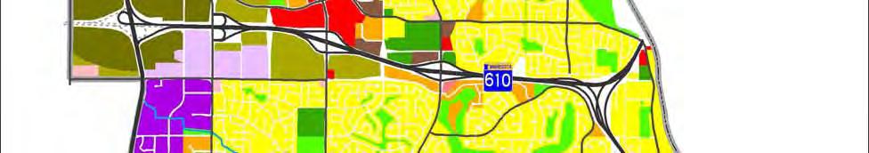
7 Brooklyn Blvd The proposed Brooklyn Boulevard LRT Station lies within a large suburban commercial node characterized by big box (e.g. Target) and other auto-oriented retail uses. The Brooklyn 2030 Comprehensive Plan indicates this commercial center is expected to remain into the future. Proposed station location North Alignment C Suburban commercial uses surround the Brooklyn Boulevard Station site (viewed from the west). Alignment C begins in Brooklyn and largely follows Bottineau Boulevard through Crystal and Robbinsdale. Stations would be located at 63 rd Avenue, Bass Lake Road, and downtown Robbinsdale. Existing land uses surrounding Alignment C in Brooklyn consist of primarily industrial and commercial uses with some residential uses. The majority of these land uses are planned to remain, with some uses transitioning to business park use. At the 63rd Avenue LRT Station area, surrounding existing uses are a mix of commercial, industrial, and high-density residential land uses with an existing Metro Transit and Ride structure on the west side of CSAH 81. Uses are planned to transition to high-density residential, institutional, and mixed use. October

8 Proposed station location North This view of the 63rd Avenue LRT Station site from the west shows the Metro Transit and Ride facility on the west side of CSAH 81 and scattered commercial uses on the east side. South of 63rd Avenue, Alignment C passes into the City of Crystal. The land uses surrounding the corridor in Crystal are predominantly low-density residential to the west and commercial and airport uses to the east. The Bass Lake Road LRT Station is currently surrounded by high-density residential and commercial uses, with some park uses. The Crystal Comprehensive Plan (2011) future land use map indicates these uses are planned to remain. South of Bass Lake Road, the existing uses are primarily commercial and industrial with some park uses. Again, these land use patterns are generally planned to remain in the future. October

9 Proposed station location North The Bass Lake Road LRT Station area (viewed from the west) includes both large-scale commercial and high-density residential uses. From Crystal, Alignment C enters the northwest corner of the City of Robbinsdale at 47 th Avenue approximately four blocks north of Highway 100. The surrounding existing and planned future land uses surrounding the corridor are primarily low-density residential, with some commercial, highdensity residential, and park uses. East of the Robbinsdale (42nd Avenue) LRT Station lies downtown Robbinsdale, a large retail/office area centered on both West Broadway Avenue and CSAH 81. West of the BNSF corridor, residential uses predominate. The City of Robbinsdale Comprehensive Plan indicates increasing density in the downtown area including transition of some parcels to mixed use. October


10 Proposed station location North Alignment D1 The BNSF corridor creates a clear boundary between the commercial uses of downtown Robbinsdale to the east and the residential area to the west Robbinsdale. Alignment D1 begins near 34 th Avenue in Robbinsdale and continues south into the City of Golden Valley crossing the municipal boundary at 26 th Avenue. Sochacki North Vegetation and park uses buffer the BNSF corridor from residential uses in Robbinsdale to the east and Golden Valley to the west. Land uses surrounding Alignment D1 in Golden Valley are primarily low-density residential and park uses, with limited areas of institutional use. The City of Golden Valley Comprehensive Plan 2030 Update indicates these land uses are planned to remain. The existing and planned future land uses October

11 surrounding the Golden Valley Road and Plymouth Avenue LRT Stations are also low-density residential and park uses. Proposed station location Golden Valley Road North The Golden Valley LRT Station would be located below grade in the BNSF corridor at the boundary between park uses to the west and institutional and residential uses to the east. October

12 Proposed station location Theodore Wirth Regional North The Plymouth Avenue LRT Station is also grade separated, but closer to recreational facilities within Theodore Wirth Regional. Alignment D1 continues along the BNSF Railroad corridor southeast through eastern areas of Golden Valley, with Theodore Wirth Regional Regional to the west and low-density residential land uses to the east. Alignment D1 enters Minneapolis north of TH 55 then travels east to Penn Avenue where it joins the Alignment D common section. Currently, the primary land uses are park and lowdensity residential uses with no plans for changes in the future. Along TH 55, existing and future planned land uses are primarily low-density residential uses. Alignment D2 The D2 alignment transitions from the BNSF Railroad Corridor to street running segments through Robbinsdale and the north side of Minneapolis before rejoining the D1 alignment along TH 55 at Penn Avenue. Throughout the entire D2 Alignment, the predominant land uses are residential, including low-, medium-, and high-density residential uses, community-oriented commercial uses and institutional uses. North Memorial Medical Center is located in Robbinsdale at the north end of this alignment. The North Memorial LRT Station would serve this regional medical facility as well as existing and future commercial uses to the north. October

13 Proposed station location North Memorial Medical Center lies within a residential area along CSAH 81. The City of Minneapolis future land use plan indicates the West Broadway corridor as urban neighborhood which includes mixed residential and commercial uses. The Minneapolis Plan for Sustainable Growth and the West Broadway Alive Plan designate West Broadway as a Commercial Corridor and Penn Avenue as a Community Corridor with the surrounding area as Urban Neighborhood. They further designate the intersection of Penn Avenue and West Broadway as a Neighborhood Commercial Node (that extends from 26 th Avenue North to Oliver Avenue) that is appropriate for mixed use commercial/residential. Residential uses at the node can be medium to high density. The proposed Broadway/Penn Station would serve this existing and future commercial corridor. The proposed Plymouth LRT Station is surrounded by institutional and community commercial uses within an otherwise residential neighborhood. The Penn Avenue/Plymouth Avenue intersection is a Neighborhood Commercial Node that is appropriate for mixed use commercial/residential uses. Residential uses at the node can be medium to high density. The Minneapolis Plan designates this area as urban neighborhood as illustrated in the Future Land Use Plan. October


14 Penn Ave Proposed station location North The Broadway/Penn commercial node is surrounded by residential uses. Proposed station location Penn Ave North View of Penn/Plymouth intersection from the west. Community institutional uses are a focus of this neighborhood intersection. October

15 Penn Ave Alignment D Common Section Alignment D is located entirely in Minneapolis, beginning at Penn Avenue and following TH 55 to 6 th Avenue North into downtown Minneapolis. Stations would be located at Van White Boulevard and The Interchange. The land use surrounding the Alignment D common section are primarily low- and medium-density residential between Penn Avenue and I-94. Future land uses in this area are designated as urban neighborhood use, which includes religious, institutional, and open space uses. Existing institutional and religious uses (academic facilities, a community center, library and a church) are adjacent to the corridor near TH 55 between Irving Avenue and Bryant Avenue. The western portions of the new Heritage neighborhood contain a mix of residential land uses including medium-, and highdensity housing. This land use pattern continues to Lyndale Avenue/I-94, where the corridor enters downtown Minneapolis. The Minneapolis Plan for Sustainable Growth indicates that residential land uses will remain in the area surrounding the proposed Penn Avenue Station. The Plan also indicates no planned changes to the existing land uses in the area surrounding the Van White LRT Station. TH 55 Proposed station location TH 55, viewed here from the south at Penn Avenue, lies within a residential neighborhood through this segment. East of I-94, Alignment D enters the downtown area of Minneapolis, characterized by commercial and industrial uses. The alignment terminates at Target Field Station which is currently transitioning from industrial uses to a signature mixed-use development adjacent to the Minnesota Twins ballpark as indicated in The Future Land Use Plan map for the Downtown Sector from The Minneapolis Plan. The terminal station would be located at The Interchange, an intermodal transit station under construction and planned to open in The North Loop Small Area Plan (2010) guides October

16 redevelopment for the North Loop area and calls for mixed use developments organized to support transit. TH 55 Proposed station location The Van White LRT Station lies within a recently redeveloped neighborhood with a variety of housing densities. October

17 Future site of The Interchange Proposed station location North Alignment D terminates at the Interchange, a multi-modal facility under construction in downtown Minneapolis. 2.3 Comprehensive Plan Compatibility This section evaluates the compatibility of the transitway with land use planning policies. No-Build Alternative The No-Build Alternative would not be compatible with City comprehensive plans, which call for support of transit as described below. Transportation System Management Alternative The Transportation System Management alternative would provide some transit improvements, and would therefore partially fulfill the intent of regional and local comprehensive plans to support and develop transit in the corridor. Build Alternatives An objective of the City of Maple Grove 2008 Comprehensive Plan is that multi-modal transportation be planned for and invested in to slow the growth of congestion. Strategies supporting this objective include promoting the evaluation of light rail and other modes of transit, planning land use patterns to support transit development, continuing to support the integration of land uses enabling shared parking and transit-oriented developments, and planning for the concentration of jobs and housing around transit hubs and daily conveniences. In addition, Maple Grove s comprehensive plan acknowledges that all areas designated as mixed use that have not been developed have the potential for transit-oriented higher-density clustered or mixed-use development, including the Gravel Mining Area. Overall, the Bottineau Transitway would be compatible with Maple Grove land use planning policies. Within Brooklyn, the Bottineau Transitway Project is compatible with local land use planning policies. The Brooklyn 2030 Comprehensive Plan acknowledges that CSAH 81 is currently being October
18 studied by Hennepin County and Metro Transit for use as a transit corridor. The plan states that the City encourages a thorough analysis of the corridor to provide the most cost-effective and efficient mode of transit and to construct it in a timely manner. In addition, Brooklyn s comprehensive plan recognizes that changes are necessary to implement the policies and objectives of the plan, including the consideration of transit overlay districts in areas where the City plans to have transit connections in the future, including Bottineau Boulevard. Additionally, the plan calls for promoting transit-oriented development where possible, and encouraging commercial higher density residential uses along transit routes. The proposed station locations would provide access to employment centers and other major destinations in Brooklyn, which would be compatible with these goals. The Bottineau Transitway Project is consistent with Crystal s local land use planning policies. It is a policy of the City of Crystal, Minnesota Comprehensive Plan Update Through the Year 2030 (2011) to plan and invest in multi-modal transportation choices, based on the full range of costs and benefits, to slow the growth of congestion and serve the region s economic needs. A strategy supporting this policy is to expand the transit system. The Public Transit chapter of Crystal s comprehensive plan supports the development of the Bottineau Transitway Project with LRT as the preferred technology. The Bottineau Transitway Project is compatible with Robbinsdale s local land use planning policies articulated in the City of Robbinsdale Comprehensive Plan. An objective of Robbinsdale s comprehensive plan is to provide an effective choice of transportation modes for the city s residents. The plan states that transit corridors provide the potential for concentrations of residential uses that may accommodate the regional projections for increased population. The plan also states that the City should coordinate all future downtown redevelopment with a transit hub, exclusive busway and light rail transit plans. In addition, the transitway is included on Robbinsdale s Transit Routes map (Figure 4G of the comprehensive plan). The transportation chapter of Robbinsdale s comprehensive plan acknowledges the Bottineau Transitway planning efforts, expressing a preference for LRT. The City of Golden Valley Comprehensive Plan 2030 Update includes the goal of enhancing transit usage. A supporting objective is to support local and regional transit provider plans and programs that benefit residents and visitors in the community. Although Golden Valley s comprehensive plan does not specifically mention the Bottineau Transitway Project, light rail would be compatible with the Plan. The Bottineau Transitway Project is compatible with the City of Minneapolis local land use planning policies. The transportation chapter of The Minneapolis Plan for Sustainable Growth (2009), indicates that enhanced transit services are the means to efficiently meeting the needs of the traveling public. The plan also calls for ongoing investment and development of corridors served by light rail, commuter rail, streetcars, and buses. Additionally, The Minneapolis Plan for Sustainable Growth s future Transitway System map acknowledges potential Bottineau Transitway routes, noting that transitway alignments and station locations are still under review and subject to change. Regional Compatibility Metropolitan Council s Regional 2030 Transportation Policy Plan (2010) acknowledges ongoing study of the Bottineau corridor as a future transit route. Policy 15 of the Transportation Policy Plan addresses transitway development and implementation. The policy states that the Metropolitan Council will strongly pursue, in coordination with CTIB, county regional railroad authorities and transit providers, the cost-effective implementation of a regional network of transitways to provide a traveltime advantage for transit vehicles, improve transit service reliability and increase the convenience and attractiveness of transit service. Strategies supporting Policy 15 refer to land use. Strategy 15c states that Metropolitan Council will consider readiness, priority, and timing along with local commitment to transitway implementation October
19 and land use when making transitway investments. Strategy 15g states that local units of government are expected to develop local comprehensive plans, zoning, and community development strategies that ensure more intensified development along transitways and that this development should be effectively linked to the transitway through compact, walkable environments. The Bottineau Transitway is compatible with local and regional land use planning policies Construction Phase Impacts Construction phase impacts are defined as the temporary impacts that occur during project construction only. No-Build Alternative No construction impacts would occur under the No-Build Alternative. Therefore, there are no construction-related land use compatibility issues for this alternative. Transportation System Management Alternative Construction phase impacts would be limited to the area of the transit center and park-and-ride facility at 97th Avenue and West Broadway Avenue. There are no land use planning policy compatibility issues for this alternative. Build Alternatives Construction phase impacts generally include: Traffic detours resulting in traffic increases through residential neighborhoods. Noise, dust, and visual impacts due to construction. Temporary effects to land use due to staging areas. Staging areas have not yet been identified for the Bottineau Transitway. These impacts do not pose compatibility issues with planning policy documents. Negative impacts such as those listed above are addressed under other topic areas (community cohesion, noise, etc.) Indirect/Secondary Impact Indirect effects related to potential for redevelopment are addressed in the Economic Impacts Technical Memo. 2.4 Avoidance, Minimization, and/or Mitigation Measures As all alignments are compatible with land use planning policy documents, no avoidance, minimization, or mitigation measures are needed. 3.0 Summary All alignments are compatible with land use planning policy documents. Therefore, any selected alternative would be compatible with land use planning policies as well. October
20 APPENDIX A List of Referenced Planning Documents October 2012
21 Land Use Planning Documents City of Maple Grove 2008 Comprehensive Plan Brooklyn 2030 Comprehensive Plan Crystal Comprehensive Plan City of Robbinsdale Comprehensive Plan City of Golden Valley Comprehensive Plan 2030 Update The Minneapolis Plan for Sustainable Growth Metropolitan Council s Regional 2030 Transportation Policy Plan October 2012
22 APPENDIX B Existing and future land use maps for Maple Grove, Brooklyn, Crystal, Robbinsdale, Golden Valley, and Minneapolis October 2012

23 Figure

24 Figure 2.8 lviaj Ie Grove Land Use Plan-PI'O)lOSE~d (Revised 11/24/08) ). D Low-Medium Density Residential 0 M~dium-Density Residential - High-Density Residential c ommercial D Industrial IZ2I Mixed-Use Development D Gravel Mining Special Area Plan D Public and Sem>Public D, Golf Course or Protected Open Space (Public or Private) E:::J Wetland or Floodplain Neighborhood Community Playfield Conservancy Unear Regional Trail.!:' Schools,..See Figures 2:11 & 2.12 and Section 2.4b in Land Use Plan This map is a general, conceptjjal guide to land development It is subject to change -and interpretation by the City Council. Further direction is provided by guidelines in the pl.an text

25 3-13


26 Land Use Definitions The following definitions are meant to clarify the intent of the land use designations and provide a general vision of uses allowed in each designation. Actual allowable uses are conveyed through the City s Zoning Ordinance. Low Density - Developments in areas designated as low density may not exceed 3 units per acre Medium Density - Developments in areas designated as medium density must be more than 3 units per acre and may not exceed 9 units per acre High Density - Developments in areas designated as high density must be more than 9 units per acre and may not exceed 25 units per acre 3-17
27 FIGURE F-1(a) 2000 EXISTING LAND USE (NORTH HALF) # 62ND AVE N Existing Land Use, TH AVE N 58TH AVE N REGENT AVE N HAMPSHIRE AVE N WEST BROADWAY AVE 58TH AVE N ORCHARD BASS LAKE RD 56TH AVE N WILSHIRE BLVD BOTTINEAU BLVD VERA CRUZ AVE N 54TH AVE N 2030 Land Use Class LDR MDR HDR NC GC I 51ST AVE N BOTTINEAU BLVD FAIRVIEW AVE N Airport Railway Other Undev (I) Other Undev (LDR) Public-Inst (GC) Public-Inst (HDR Public-Inst (LDR) Public-Inst- Road Rights-of-Way 47TH AVE N 47TH AVE N WELCOM ADAIR AVE N DOUGLAS DR N LOUISIANA AVE N Miles 45TH AVE N N CRYSTAL COMPREHENSIVE PLAN PROPOSED FINAL VERSION PAGE 28
28 FIGURE F-2(a) 2010 EXISTING LAND USE (NORTH HALF) 62ND AVE N Existing Land Use, TH AVE N HAMPSHIRE AVE N WEST BROADWAY AVE 58TH AVE N 56TH AVE N WILSHIRE BLVD 54TH AVE N FAIRVIEW AVE N 58TH AVE N REGENT AVE N ORCHARD BASS LAKE RD BOTTINEAU BLVD VERA CRUZ AVE N 2030 Land Use Class LDR MDR HDR NC GC 51ST AVE N BOTTINEAU BLVD 47TH AVE N 47TH AVE N WELCOM ADAIR AVE N DOUGLAS DR N LOUISIANA AVE N 45TH AVE N N I Airport Railway Other Undev (I) Other Undev (LDR) Public-Inst (GC) Public-Inst (HDR Public-Inst (LDR) Public-Inst- Road Rights-of-Way Miles CRYSTAL COMPREHENSIVE PLAN PROPOSED FINAL VERSION PAGE 30 #
29 FIGURE F-3(a) 2030 PLANNED LAND USE (NORTH HALF) 62ND AVE N Planned Land Use, TH AVE N HAMPSHIRE AVE N WEST BROADWAY AVE 58TH AVE N 56TH AVE N WILSHIRE BLVD 54TH AVE N FAIRVIEW AVE N 58TH AVE N REGENT AVE N ORCHARD BASS LAKE RD BOTTINEAU BLVD VERA CRUZ AVE N 2030 Land Use Class LDR MDR HDR NC GC 51ST AVE N BOTTINEAU BLVD 47TH AVE N 47TH AVE N WELCOM ADAIR AVE N DOUGLAS DR N LOUISIANA AVE N 45TH AVE N N I Airport Railway Other Undev (I) Other Undev (LDR) Public-Inst (GC) Public-Inst (HDR Public-Inst (LDR) Public-Inst- Road Rights-of-Way Special Area Plan A (See Text) Miles CRYSTAL COMPREHENSIVE PLAN PROPOSED FINAL VERSION PAGE 32 #

30 Figure 2A Existing Land Patterns 2-4

31 Figure 2B Future Land Use Map 2-10
32 E Railroad JERSEY AVE Chapter 3: Land Proposed Use Local Trail 3-3 PED Figure 3.1: Existing Pedestrian Land Bridge Use Map S T A T E H I G H W A Y CITY OF PLYMOUTH 169 M E N D E L S S O H N A V E N U E inch = 1,833 feet Thibault ASSOCIATES Golden Valley May 1999 Medley Hills Hennepin County Radio Lakeview Public Works GOLDEN VALLEY ROAD B E T T Y C R O C K E R Comprehensive Plan CITY OF NEW HOPE B O O N E A V E N U E SOUTH FRONTAGE RD Existing Local Trail Regional Trail Proposed Regional Trail Road Rights-of-Way Municipal Line D R M I L L S B L V D G E N E R A L Urban Planning Development Redevelopment Housing U n i o n P a c i f i c R R Wesley Æÿ WISCONSIN AVE D U L U T H S T R E E T Golden Oaks North Hennepin French - Wirth Trail 1 0 T H A V E N U E Brookview Golf Course (Public) Westwood Hills Environmental Education Center W I N N E T K A A V E N U E M E D I C I N E L A K E R O A D W I N N E T K A A V E N U E RHODE ISLAND AVE Pennsylvania Woods O L Y M P I A Library I S L A N D A V E Government Center Post PED Office Brookview R H O D E H A R O L D Western Avenue Marsh PED W E S T E R N S T NEVADA AVE Wildwood Sigurd Olson Elementary School P L Y M O UT H A V E N U E G O L D E N S T A T E B A S S E T T S V A L L E Y R O A D C O U N T R Y C L U B D R I V E A V E N U E C a n a d i a n P a c i f i c Lions A V E N U E L A U R E L A V E N U E LOUISIANA AV S A N D B U R G MARKET ST R R Hampshire Golden Valley Golf Club (Private) H I G H W A Y C R E E K Sandburg Middle School 5 5 R O A D Seeman DOUGLAS DRIVE D O U G L A S D R I V E 102 D U L U T H ST (Cedar Lake-MN Valley) Regional Trail FLORIDA AVE FRONTAGE RD WAYZATA BLVD CROIX Potential South Hennepin Minnesota Center of the Arts G L E N W O O D Valley School Laurel Laurel Avenue Avenue Greenbelt South Cortlawn (King Creek) PED Honeywell Pond CITY OF ST. LOUIS PARK CITY OF CRYSTAL R R P a c i f i c AVE Proposed PED S T R E E T GOLDEN VALLEY ROAD C a n a d i a n Z A N E A V E LINDSAY STREET FRONTAGE RD A V E N U E GOLDEN HILLS DR FRONTAGE RD A V E X E N I A L I L A C D R I V E NORTH LILAC DR Bassett Creek Nature Area Mn/DOT St. Croix Yosemite K I N G I N T E R S T A T E C R E E K Æÿ 100 S T A T E H I G H W A Y Meadowbrook Elementary School TURNERS CROSSROAD Gearty Briarwood Nature Area 394 C U L V E R R E G E N T A V E N U E PED Scheid 34TH Briarwood Bird and Wildlife Sanctuary FRONTAGE RD FRONTAGE RD AVENUE Breck School R O A D C a n a d i a n P a c i f i c RR S W E E N E Y Æÿ 100 N O B L E A V E N U E Noble Elementary School G O L D E N Schaper Natchez Stockman V A L L E Y T W I N L A K E G L E N W O O D JUNE AVENUE Rice Lake Nature Area L A K E R O A D U n i o n P a c i f i c RR A V E N U E North Tyrol PED North Hennepin French - Wirth Trail M E A D O W L A N E SOUTH FRONTAGE RD CITY OF GOLDE CITY OF ROBBINSDALE 26TH AVENUE Mary Hills Theodore Wirth Golf Course (Public) Wirth - Memorial way Trail Æÿ 55 W I R T H P A R K W A Y C a n a d i a n Potential Glenview Terrace B A S S E T T S Santa Fe RR C R E E K Trail Theodore Wirth Theodore Wirth Regional Z E N I T H A V E W I R T H L A K E Burlington PLYMOUTH AV P a c i f i c R R Link Northern Bassetts Creek Trail Bassetts Creek Trail X E R X E S A V E N U E CITY OF MINNEAPOLIS GE RE CO IN 1 in Thib ASSO Urba Residential Low Density (0.1 to 5 units per acre) 2714 acres Medium Density (5 to 11.9 units per acre) 201 acres High Density (12 to 20 units per acre) 100 acres Industrial Light Industrial (also includes office) 85 acres Industrial (also includes office) 95 acres I-394 Mixed Use (includes approximately 25 percent 200 acres residential, 5 to 11.9 units per acre) DOUGLAS AVENUE South Tyrol Public & Semi-Public Schools & Religious Facilities 1,375 acres Public Facilities (miscellaneous) 403 acres Semi-Public Facilities (miscellaneous) 305 acres Golden May 19 Commercial & Open Space Railroad 150 acres Office 95 acres Commercial (also includes office) 95 acres Date: May 1999 Source: Golden Valley Comprehensive Plan, Open Space (public and private ownership) 58 acres Open Water (Based on 2008 aerial photos) 295 acres Wetlands National Wetlands Inventory - not field verified (Minor adjustments made to some wetlands.) 169 acres Existing Local Trail Proposed Local Trail Regional Trail Proposed Regional Trail Pedestrian Bridge Road Rights-of-Way Municipal Line 700 acres City of Golden Valley Comprehensive Plan
 Medium High Density (12 to 19.")
33 Chapter 3: Land Use 3-7 Figure 3.4: Land Use Plan Map Theodore Wirth Regional (Mpls & Rec Board) Residential Low Density (0.1 to 5 units per acre) Medium Low Density (5 to 11.9 units per acre) Medium High Density (12 to 19.9 units per acre) High Density (20 to 30 units per acre) Commercial Office Retail/Service (also includes office) Industrial Light Industrial (also includes office) Industrial (also includes office) Mixed Use (includes approximately 25 percent residential, 5 to 11.9 units per acre) Open Space (public and private ownership) Schools & Religious Facilities Public Facilities (miscellaneous) Semi-Public Facilities (miscellaneous) Open Water Wetlands (National Wetlands Inventory, Barr Engineering, and HR Green 1999 SWMP - not field verified) Railroad Road Rights-of-Way Private Streets Municipal Line Date: December 4, 2008 Sources: Hennepin County Surveyors Office for Property Lines (2008), DNR, HR Green, Barr Engineering for Wetlands, City of Golden Valley for all other layers City of Golden Valley Comprehensive Plan
34 Map 1.1: Existing Land Use Citywide Legend Existing Land Use Low-Density Housing (up to 20 DU/acre) Medium-Density Housing (20-50 DU/acre) High-Density Housing ( DU/acre) Very High-Density Housing (>120 DU/acre) Congregate Living Commercial Mixed Use Public/Institutional Cultural/Entertainment Transportation/Communication/Utilities Industrial s/open Space Vacant Centerline Water / Source: City of Minneapolis Created by: Minneapolis Community Planning and Economic Development Department Planning Division Adopted by City Council October 2, ,500 5,000 10,000 15,000 Feet 1-33
35 Map 1.2: Future Land Use Citywide Legend p h g # * Transit Station Growth Center Major Retail Center Activity Center Neighborhood Commercial Node Industrial Employment District Commercial Corridor Community Corridor Centerline Urban Neighborhood # * Mixed Use Commercial # * Public and Institutional Transitional Industrial Industrial s and Open Space Water p pp # *h gp h g p p p h g p Urban neighborhood contains a range of residential densities, with a limited amount of other uses appropriate in a residential setting. p Text p p For more details on categories, see narrative in land use chapter. h g # * # * * p# / p Source: City of Minneapolis p Created by: Minneapolis Community Planning and Economic Development Department Planning Division Adopted by City Council October 2, 2009 Amended March 22, 2011 Amended August 16, 2011 p # * # * 0 2,500 5,000 10,000 15,000 Feet 1-39
36 Map 1.1a: Existing Land Use Downtown Sector Legend Existing Land Use Low-Density Housing (up to 20 DU/acre) Medium-Density Housing (20-50 DU/acre) High-Density Housing ( DU/acre) Very High-Density Housing (>120 DU/acre) Congregate Living Commercial Mixed Use Public/Institutional Cultural/Entertainment Transportation/Communication/Utilities Industrial s/open Space Vacant Centerline Water / Source: City of Minneapolis Created by: Minneapolis Community Planning and Economic Development Department Planning Division Adopted by City Council October 2, ,500 5,000 Feet 1-34
37 Map 1.2a: Future Land Use Downtown Sector #* Legend p Transit Station hg Growth Center #* Major Retail Center Activity Center Neighborhood Commercial Node Industrial Employment District Commercial Corridor Community Corridor Urban Neighborhood Mixed Use Commercial Public and Institutional p Transitional Industrial Industrial s and Open Space p #* p hg p p Water / p hg Urban neighborhood contains a range of residential densities, with a limited amount of other uses appropriate in a residential setting. For more details on categories, see narrative in land use chapter. 0 2,500 5,000 10,000 Feet Source: City of Minneapolis Created by: Minneapolis Community Planning and Economic Development Department Planning Division Adopted by City Council October 2, 2009 Amended March 22, 2011 Amended August 16,
Blue Line LRT Extension
 v e Noble Pkwy Noble Pkwy Xerxes Ave N Shingle Creek Penn Ave N Penn Ave N Fremont Ave N Lyndale Ave N S Washington Ave University Ave NE Blue Line LRT Extension LIGHT RAIL PLATFORM AND STATION DESIGN
Place and Opportunity: An Equity Assessment of the Twin Cities Region (www.metrocouncil.org/
 1 Purpose and Need This chapter gives an overview of the proposed METRO Blue Line Light Rail Transit (BLRT) Extension project, including its location and setting within the local communities and the region,
West Broadway Transit Study Initial Screening of Alternatives Memo
 West Broadway Transit Study Initial Screening of Alternatives Memo 5/22/2015 Prepared by the SRF Consulting Group Team for Table of Contents Purpose... 1 Methodology... 1 Screening... 5 Screening Criteria...
Corridor Vision. 1Pursue Minnehaha-Hiawatha Community Works Project. Mission of Hennepin County Community Works Program
 1Pursue Minnehaha-Hiawatha Community Works Project Minnehaha-Hiawatha Community Works is a project within the Hennepin Community Works (HCW) program. The mission of the HCW program is to enhance how the
Gold Line Bus Rapid Transit Transit Oriented Development (BRTOD) Helmo Station Area Plan
 Helmo Station Area Plan") Appendix F Gold Line Bus Rapid Transit Transit Oriented Development (BRTOD) Helmo Station Area Plan Introduction and Purpose of the Plan The Gold Line Bus Rapid Transit facility is an eleven-mile dedicated
Appendix F Gold Line Bus Rapid Transit Transit Oriented Development (BRTOD) Helmo Station Area Plan Introduction and Purpose of the Plan The Gold Line Bus Rapid Transit facility is an eleven-mile dedicated
Technical Report Visual Quality
 Executive Summary Technical Report Visual Quality Table ES-1. Summary of Impacts and Mitigation Measures Impact Category Impacts of Build Alternatives Avoidance, Minimization, and/or Mitigation Measures
DEVELOPMENT FRAMEWORK POST 2030 LAND USE PLAN INTRODUCTION
 INTRODUCTION Oak Grove s Comprehensive Plan identifies a future Metropolitan Urban Service Area (MUSA). The Metropolitan Council does not anticipate extending utilities to this area prior to 2030. The
This chapter describes the purpose of the Plan, introduces how the Plan is organized and provides contextual background for the Plan.
 Chapter 1: INTRODUCTION Purpose of a Comprehensive Plan The 2040 Comprehensive Plan establishes Medina s vision as a community and sets goals and objectives which guide future decisions and policies. The
ROBBINSDALE LRT STATION CDI DEVELOPMENT GUIDELINES
 August 2018 OVERVIEW The City of Robbinsdale has a prime-opportunity site in the middle of the 13 mile stretch of the Bottineau LRT corridor / Blue Line extension. Robbinsdale offers a prominent, vital,
Tracking the Blue Line Extension
 BROOKLYN PARK CRYSTAL ROBBINSDALE GOLDEN VALLEY MINNEAPOLIS Tracking the Blue Line Extension Issue 11 April 2018 Goals to finish designs, apply for federal funds in 2018 Rendering of the 63rd Avenue Station
Right-of-Way Acquisitions and Relocations Technical Memorandum
 Right-of-Way Acquisitions and Relocations Technical Memorandum Southeast Extension Project Lincoln Station to RidgeGate Parkway Prepared for: Federal Transit Administration Prepared by: Denver Regional
Welcome. Comprehensive Plan & Transportation Plan Open House November 7, 2012
 Welcome Comprehensive Plan & Transportation Plan Open House November 7, 2012 Agenda Proposed future land use plan Comprehensive Plan strategies Traffic forecasts Future traffic operations Possible future
Robbinsdale LRT Station. CDI Development Guidelines. August Overview
 Robbinsdale LRT Station August 2018 Overview The City of Robbinsdale may have the coolest opportunity site along the 13 mile stretch of the Bottineau LRT corridor / Blue Line extension. Located a block
Chapter 1: Introduction
 Chapter 1: Introduction The Penn Avenue Community Works Corridor Vision and Implementation Framework presents an integrated communitybased vision and a coordinated, long-term implementation framework for
Corridor Management Committee. April 14, 2016
 Corridor Management Committee April 14, 2016 1 Today s Topics Chair s Update Corridor-wide Safety/Security Golden Valley Rd Park & Ride, Trails and Intersection Section 106 (Historic Properties) Update
Mary Hills Nature Area. Roadway Lighting. The Minneapolis Clinic of Neurology Courage Kenny Rehabilitation Institute
 PUBLIC REALM IMPROVEMENTS Mary Hills Nature Area Enhanced Programming Glenview Terrace Valley View Roadway Lighting Enhanced Streetscape Trail Lighting / Roadway Lighting Wayfinding Public Art The Minneapolis
Planning Districts INTRODUCTION
 INTRODUCTION To facilitate detailed examination of development prospects for all areas of the community, Delano has been divided into 14 planning districts. The location of these planning districts is
Mississippi Skyway Preliminary Engineering Report
 EXECUTIVE SUMMARY Mississippi Skyway Preliminary Engineering Report CITY OF RAMSEY, MINNESOTA DECEMBER 2014 City of RAMSEY EXECUTIVE SUMMARY Project Need and Intent The Mississippi Skyway pedestrian bridge
POCKET COMMUNITY PLAN
 POCKET COMMUNITY PLAN Part Three : COMMUNITY PLAN AREAS AND SPECIAL STUDY AREAS CONTENTS Community Location... 3-P-3 Community Vision... 3-P-4 Community Profile... 3-P-4 Community Issues... 3-P-6 Land
Northwest Rail Corridor and US 36 BRT Development Oriented Transit Analysis 4.4 STATION AREA FINDINGS
 4.4 STATION AREA FINDINGS Each station is different, and each one requires a separate set of recommendations based on the vision for the site. This section outlines an initial TOD strategy and recommendations
Table of Contents. Elm Avenue Improvement Plan City of Waco, Texas. Introduction 1. Existing Context 1 Figure 1 2.
 Table of Contents Introduction 1 Existing Context 1 Figure 1 2 Plan Guidelines 3 Future Urban Form 4 The West-End 4 Main Street 6 The East-End 7 Figure 2 9 Public Improvement Recommendations 7 General
Subject: City of Richfield Cedar Avenue Corridor Plan Comprehensive Plan Amendment, Review File No
 Committee Report Business Item No. 2017-21 Community Development Committee For the Metropolitan Council meeting of January 25, 2017 Subject: City of Richfield Cedar Avenue Corridor Plan Comprehensive Plan
Transportation Committee
 Transportation Committee Business Item No. 2013-286SW Meeting date: October 14, 2013 For the Metropolitan Council meeting of October 16, 2013 Subject: Southwest Light Rail Transit (Green Line Extension):
Grand Rounds History
 Grand Rounds History 1883 Plan for Minneapolis Park System prepared by Landscape Architect Horace W. S. Cleveland. The system of connecting parks and parkways was first called the Grand Rounds by William
EXECUTIVE SUMMARY DRAFT CHAPTER 1 INTRODUCTION EXECUTIVE SUMMARY
 CHAPTER 1 EXECUTIVE SUMMARY INTRODUCTION Through the joint efforts of the City of Tulsa planning staff and the Land Services division of Indian Nations Council of Governments (INCOG), the Berryhill Land
FUTURE LAND USE ELEMENT
 FUTURE LAND USE ELEMENT GOAL I: To create and sustain a great place to live, play, and prosper Objective 1: The City of Ocala shall incorporate the principles and strategies of the Ocala 2035 Vision into
1.0 Introduction. Purpose and Basis for Updating the TMP. Introduction 1
 1.0 Introduction The Town of Castle Rock is situated between the metropolitan areas of Denver and Colorado Springs, amidst a unique terrain of rolling hills, mesas, ravines, and waterways. Like many Front
BROOKLYN PARK / 85TH AVE LRT STATION CDI DEVELOPMENT GUIDELINES DRAFT
 August 2018 Page intentionally left blank The Brooklyn Park Library adjacent to the 85th Ave LRT Station Area. OVERVIEW The Blue Line LRT Extension / Bottineau corridor offers a unique opportunity to leverage
Implementation Guide Comprehensive Plan City of Allen
 Implementation Guide 2030 Comprehensive Plan City of Allen DRAFT 2015 Implementation Guide Allen 2030 Comprehensive Plan INTRODUCTION The Comprehensive Plan serves as a guide for the growth and development
WORK SESSION STAFF REPORT Work Session Item No. 2. Michael Grochala, Community Development Director
 WORK SESSION STAFF REPORT Work Session Item No. 2 WS Item 2 Date: March, 2018 To: From: Re: City Council Michael Grochala, Community Development Director 200 Comprehensive Plan Mixed Use Districts Background
Section 3: Land Use M C H E N R Y K A N E. Figure 3.1: Potential Future Municipal Boundaries. Future Municipal Boundaries. County Land Use Plans
 Section 3: Land Use Figure 3.1: Potential Future Municipal Boundaries Land use and transportation are intertwined; yet, land use and transpor- tation planning are often undertaken as separate disciplines.
Issues Requiring Future Study
 Issues Requiring Future Study Transportation planning is an ongoing process that tends to identify new issues as it finds solutions for others. Some issues are so complex that a solution to one problem
Town Center. Block 5 Existing multifamily residential units are expected to remain.
 Area Guidelines Germantown s districts should be developed as distinct communities with unique features that are supported through the guidelines. The guidelines not only help distinguish these districts
Regency Developments. Urban Design Brief. Holyrood DC2 Rezoning
 Regency Developments Urban Design Brief Holyrood DC2 Rezoning Stantec Consulting Ltd. 7-31-2017 1. Overview Regency Developments intends to rezone the lands located at 8510 and 8511 93 Avenue, within the
Community Working Group Meeting #3. Agenda
 METRO Blue Line extension (Bottineau LRT) Phase 1: Station Area Planning Community Working Group Meeting #3 Wednesday, December 17, 2014 6:00 8:00 pm Urban Research and Outreach-Engagement Center (UROC)
Seneca Meadows. Block 4 Locate office, technology, and medical development adjacent to I Screen views of garage structures from I-270.
 Seneca Meadows Seneca Meadows has an industrial park in its southern end and a mixed-use employment area planned for the north end. The district benefits from extensive I-270 visibility, stream valley
MODEL ACCESS MANAGEMENT PLAN MINNESOTA TRUNK HIGHWAY 7 COMPREHENSIVE PLAN AMENDMENT (HUTCHINSON SEGMENT)
") MODEL ACCESS MANAGEMENT PLAN MINNESOTA TRUNK HIGHWAY 7 (HUTCHINSON SEGMENT) COMPREHENSIVE PLAN AMENDMENT INTRODUCTION. The purpose of this plan is to provide consistent access management in the Trunk
MODEL ACCESS MANAGEMENT PLAN MINNESOTA TRUNK HIGHWAY 7 (HUTCHINSON SEGMENT) COMPREHENSIVE PLAN AMENDMENT INTRODUCTION. The purpose of this plan is to provide consistent access management in the Trunk
124 Subarea Visions. Vision Plan. A. Nelessen Associates, INC I Visioning I Planning I Urban Design
 Subareas 124 Subarea Visions The next seven sections describe specific recommendations tailored to each subarea. Each subarea is discussed separately except for certain aspects of 95th Street and Antioch
To ensure that resources will be available to provide a consistent level of public services to the community.
 Future Land Use Plan The land use plan is one of the most prominent chapters in the Stillwater Comprehensive Plan. It provides a visual representation of what the community is expected to look like in
Staff Report and Recommendation
 Community Planning and Development Planning Services 201 W. Colfax Ave., Dept. 205 Denver, CO 80202 p: 720.865.2915 f: 720.865.3052 www.denvergov.org/cpd TO: City Council Neighborhoods and Planning Committee
VISUALIZATION TOOLS FOR COMMUNICATION & DECISION MAKING REAL MINNESOTA EXAMPLES
 REAL MINNESOTA EXAMPLES 23rd Annual CTS Transportation Research Conference Leif Garnass, P.E., PTOE Senior Engineer lgarnass@srfconsulting.com Sean Jergens, ASLA, LEED AP Senior Landscape Architect sjergens@srfconsulting.com
Corridor Background. Defining the Corridor Study Area. Lake Street. 38th Street. 46th Street
 1 Corridor Background Defining the Corridor Study Area Minnehaha Avenue (CSAH 48) and Hiawatha Avenue (MN 55) are parallel diagonal roadways, approximately three blocks apart, that provide two direct arterial
Missing Link Study Grand Rounds Parkway Planning and Design Introduction
 Missing Link Study Grand Rounds Parkway Planning and Design Introduction June 19, 2007 Minneapolis Park and Recreation Board HNTB Hoisington Koegler Group Inc. Hess Roise 1 The Missing Link Study The Minneapolis
CHAPTER 1. Ms. Guajardo s Class - Central Elementary CH 1 1
 INTRODUCTION CHAPTER 1 Ms. Guajardo s Class - Central Elementary CH 1 1 1.1 SETTING South Centre City is a linear corridor south of Downtown Escondido paralleling Centre City Parkway and South Escondido
YONGE STEELES CORRIDOR SECONDARY PLAN. Young + Wright / IBI Group Architects Dillon Consulting Ltd. GHK International (Canada) Ltd.
 Ltd.") PART A: PREAMBLE 1.0 PURPOSE The purpose of this Secondary Plan is to provide a development framework for intensification of the Yonge/ Steeles corridor including the north side of Steeles Avenue West
PART A: PREAMBLE 1.0 PURPOSE The purpose of this Secondary Plan is to provide a development framework for intensification of the Yonge/ Steeles corridor including the north side of Steeles Avenue West
CHAPTER 7: VISION AND ACTION STATEMENTS. Noble 2025 Vision Statement
 CHAPTER 7: VISION AND ACTION STATEMENTS This chapter presents the vision, policy and action statements that transform the comprehensive planning study, an analysis of Noble s past, future trends and community
Midtown Greenway Land Use and Development Plan Executive Summary
 Midtown Greenway Land Use and Development Plan Executive Summary Introduction The Midtown Greenway Land Use and Development Plan sets policy direction for land use and development in the Midtown Greenway
12/9/2013. HOLLYWOOD/PINES CORRIDOR PROJECT AMPO 2013 Annual Conference October 24, Our Perspective. Broward.
 HOLLYWOOD/PINES CORRIDOR PROJECT AMPO 2013 Annual Conference October 24, 2013 Our Perspective Broward Fort Lauderdale 1 Broward Metropolitan Planning Organization Fort Lauderdale Fort Lauderdale Skyline
LAND USE MEADOWS PLANNING AREA
 LAND USE MEADOWS PLANNING AREA I. Profile of Meadows Planning Area A. Location Meadows Planning Area is delineated by I-5 on the north, the Nisqually Bluffs representing the growth boundary on the east,
CHAPTER 3: LAND USE. 3.1 Purpose. 3.2 Influencing Factors
 CHAPTER 3: LAND USE 3.1 Purpose The Land Use Plan establishes the direction for guiding development and redevelopment in the City. The plan provides the framework for land use decisions through 2040. The
CHAPTER 7: Transportation, Mobility and Circulation
 AGLE AREA COMMUNITY Plan CHAPTER 7 CHAPTER 7: Transportation, Mobility and Circulation Transportation, Mobility and Circulation The purpose of the Transportation, Mobility and Circulation Chapter is to
PUBLIC OPEN HOUSE HURONTARIO-MAIN CORRIDOR SECONDARY PLAN
 PUBLIC OPEN HOUSE HURONTARIO-MAIN CORRIDOR SECONDARY PLAN Tuesday, February 28, 2012 6pm 9pm 1 st Floor Atrium, City Hall 2 Wellington Street West, Brampton 1 POLICY FRAMEWORK The 2006 Provincial Growth
EAST SACRAMENTO COMMUNITY PLAN
 EAST SACRAMENTO COMMUNITY PLAN Part Three : COMMUNITY PLAN AREAS AND SPECIAL STUDY AREAS CONTENTS Community Location...3-ES-3 Community Vision...3-ES-4 Community Profile...3-ES-4 Community Issues...3-ES-5
Eastern Terminus TECHNICAL MEMORANDUM CENTRAL BROWARD EAST-WEST TRANSIT ANALYSIS BROWARD COUNTY, FLORIDA
 Eastern Terminus TECHNICAL MEMORANDUM CENTRAL BROWARD EAST-WEST TRANSIT ANALYSIS BROWARD COUNTY, FLORIDA FINANCIAL PROJECT ID NUMBER 411189-2-22-01 FLORIDA DEPARTMENT OF TRANSPORTATION DISTRICT 4 Prepared
West Ocala Vision & Community Plan City Council Work Session. Presented by West Ocala Community Plan Steering Committee
 West Ocala Vision & Community Plan City Council Work Session Presented by West Ocala Community Plan Steering Committee November 29,2011 Ocala 2035 Vision West Ocala Community Vision & Master Plan West
Corridor Management Committee. September 29, 2017
 Corridor Management Committee September 29, 2017 1 Today s Topics Chair s Update Proposed Corridor Protection Wall Aesthetic Design Overview Public Outreach Environmental Review Civil Construction Update
Elm Fork Land Use. Trinity River Corridor Project Committee May 13, 2013
 Elm Fork Land Use Trinity River Corridor Project Committee May 13, 2013 Purpose Discuss Trinity River planned Land Use and Appropriate Compatible Uses, particularly with respect to the Elm Fork Area 2
HAZARD MITIGATION GOALS AND OBJECTIVES
 SEWRPC Community Assistance Planning Report No. 282, 2nd Edition CITY OF MILWAUKEE ALL HAZARDS MITIGATION PLAN UPDATE Chapter IV HAZARD MITIGATION GOALS AND OBJECTIVES [NOTE: Throughout this plan update
Status Report: MD 355 Project
 Status Report: MD 355 Project OCTOBER 2006 M-NCPPC MONTGOMERY COUNTY PLANNING DEPARTMENT Summary of Community Comments, and break to the Results of the MD 355 Participation Session Brookside Gardens -
Transportation. Strategies for Action
 Transportation A major priority for the Overlake Neighborhood is to develop a multimodal transportation system. To achieve this system, a balance has to be found among travel, circulation and access needs;
7.0 SECTION 4(F) EVALUATION
 EVALUATION") Chapter 7 Section 4(f) Evaluation 7.0 SECTION 4(F) EVALUATION 7.1 Background Information and Regulatory Requirements This chapter presents the existing conditions and potential effects to parklands and
Chapter 7 Section 4(f) Evaluation 7.0 SECTION 4(F) EVALUATION 7.1 Background Information and Regulatory Requirements This chapter presents the existing conditions and potential effects to parklands and
UNIVERSITY CITY AREA PLAN. Volume Two: Implementation Plan
 UNIVERSITY CITY AREA PLAN Volume Two: Implementation Plan Transforming the University City MSD into the vibrant, people-oriented place envisioned in the University City Plan will occur incrementally through
CHARLES PUTMAN CHARLES PUTMAN AND ASSOCIATES, INC
 MEMORANDUM CHARLES PUTMAN & ASSOCIATES, INC. LAND DEVELOPMENT CONSULTANTS PLANNING ZONING PERMITTING 4722 NW Boca Raton Boulevard, Suite C-106 Boca Raton, Florida 33431 Phone: 561/994-6411 FAX: 561/994-0447
MEMORANDUM. I2 District Downtown Parking Overlay District 24,000 square feet /.55 acres. Industrial Employment District North Loop Small Area Plan
 Department of Community Planning & Economic Development 50 South 4th Street, Room 300 Minneapolis, MN 5545-385 MEMORANDUM To: City Planning Commission, Committee of the Whole Prepared By: Peter Crandall,
RESOLUTION NO. R Refining the route, profile and stations for the Downtown Redmond Link Extension
 RESOLUTION NO. R2018-32 Refining the route, profile and stations for the Downtown Redmond Link Extension MEETING: DATE: TYPE OF ACTION: STAFF CONTACT: Capital Committee Board PROPOSED ACTION 09/13/2018
June 14, 2017 for the June 20, 2017 Parks and Trails Commission Meeting
 105 South Fifth Avenue Suite 513 Minneapolis, MN 55401 Tel: 612-252-9070 Fax: 612-252-9077 www.landform.net TO: FROM: DATE: Corcoran Parks and Trails Commission Kendra Lindahl, Landform June 14, 2017 for
Overview of the Plan. The Building Blocks of Centers, Neighborhoods and Network INTERNAL DRAFT
 Overview of the Plan 4 East Davidson Ramah Church Rd June Washam Rd Bradford District Park Bradford Shearer Rd Campus District NC 73 Davidson-Concord North Rocky River This Master Plan projects an approximate
TREASURE COAST REGIONAL PLANNING COUNCIL M E M O R A N D U M. To: Council Members AGENDA ITEM 5H
 TREASURE COAST REGIONAL PLANNING COUNCIL M E M O R A N D U M To: Council Members AGENDA ITEM 5H From: Date: Subject: Staff October 17, 2008 Council Meeting Local Government Comprehensive Plan Review Draft
St. Louis Park Wooddale LRT Station Site development guidelines
 St. Louis Park Wooddale LRT Station Site development guidelines November 2013 OVERVIEW St. Louis Park s convenient location as a neighbor to Minneapolis means you re only minutes away from some of the
THE 355/270 CORRIDOR:
 THE 355/270 CORRIDOR: Strategic Ideas for Sustaining a Livable Work Place Project Summary ACCESS LIFE DESIGN HEALTH WORK Montgomery County Planning Department The Maryland-National Capital Park and Planning
APPENDIX D: Visual and Aesthetic Conditions for NCCU Station Refinement. Durham-Orange Light Rail Transit Project
 APPENDIX D: Visual and Aesthetic Conditions for NCCU Station Refinement Durham-Orange Light Rail Transit Project October 2016 1. Introduction The Combined FEIS/ROD summarizes the effects of the D-O LRT
AWH REPORT OF THE PLANNING AND DEVELOPMENT DEPARTMENT FOR APPLICATION FOR REZONING ORDINANCE TO PLANNED UNIT DEVELOPMENT
 AWH REPORT OF THE PLANNING AND DEVELOPMENT DEPARTMENT FOR APPLICATION FOR REZONING ORDINANCE TO PLANNED UNIT DEVELOPMENT MAY 8, 2014 The Planning and Development Department hereby forwards to the Planning
LAND USE OVERVIEW WHAT YOU WILL FIND IN THIS CHAPTER
 LAND USE WHAT YOU WILL FIND IN THIS CHAPTER Information about the City s expected population and employment growth. Description and capacity of existing and future land use designations. Policies that
Isabel Neighborhood Plan: Alternatives
 Isabel Neighborhood Plan: Alternatives Presented by: Lori Parks, Associate Planner February 2, 2015 Agenda 1. Background on BART to Livermore 2. Isabel Neighborhood Plan 3. Alternative Scenarios 4. General
WHAT IS THE PURPOSE OF THE OPEN HOUSE?
 WHAT IS THE PURPOSE OF THE OPEN HOUSE? OPEN HOUSE PURPOSE The purpose of the open house is to provide an update on the study process and introduce the preliminary concept alternatives. The open house provides
The transportation system in a community is an
 7 TRANSPORTATION The transportation system in a community is an important factor contributing to the quality of life of the residents. Without a sound transportation system to bring both goods and patrons
Albert Lea. Redevelopment Plan. 701 Xenia Avenue South, Suite 300 Minneapolis, MN Tel: (763) Fax: (763) wsbeng.
 Fax: (763) wsbeng.") Albert Lea Redevelopment Plan 701 Xenia Avenue South, Suite 300 Minneapolis, MN 55416 Tel: (763) 541-4800 Fax: (763) 541-1700 wsbeng.com Albert Lea Redevelopment Plan Table of Contents Composite Districts...
Albert Lea Redevelopment Plan 701 Xenia Avenue South, Suite 300 Minneapolis, MN 55416 Tel: (763) 541-4800 Fax: (763) 541-1700 wsbeng.com Albert Lea Redevelopment Plan Table of Contents Composite Districts...
REQUEST FOR COUNCIL ACTION 6A AGENDA ITEM
 DATE REQUEST FOR COUNCIL ACTION 6A AGENDA ITEM ORIGINATING DEPT. AGENDA ITEM CITY ADMINISTRATOR APPROVAL Community Development PUD Concept & Development Stage Plan Preliminary Plat & Final Plat PREVIOUS
BeltLine Corridor Environmental Study
 BeltLine Corridor Environmental Study Joint TAC and SAC Meeting December 8, 2008 What We Will Discuss Today Outreach and Agency Coordination Scoping Results Existing Conditions Historical and Archeological
Glenborough at Easton Land Use Master Plan
 Vision Statement Sunrise Blvd. Hazel Ave. Prairie City Rd. Gencorp Property Lincoln Regional Airport 1.0 VISION STATEMENT The identifies City of the principles, goals, policies, and standards Lincoln that
Planning & Zoning Commission Staff Report
 Planning & Zoning Commission Staff Report Meeting Date: May 26, 2015 Drafted by: Katherine Harrison-Rogers CASE # Z2886 PROJECT NAME: APPLICANT/ REPRESENTATIVE: Shawna Runyan PROPERTY OWNER: 1840 (previously
BUILDER LOTS FOR SALE
 BUILDER LOTS FOR SALE NORTHERN CULPEPER - 135 ACRES RESIDENTIAL DEVELOPMENT 1256 Old Bridge Road, Amissville, VA 20106 SALE PRICE: $995,000 LOT SIZE: 135+ Acres APN #: Tax Map 2 Parcel 23 ZONING: R-1 ACCESS:
Comprehensive Plan. Faribault, Minnesota. Hoisington Koegler Group Inc. Claybaugh Preservation Architecture Inc. Howard R. Green Company Bonz/REA
 Comprehensive Plan Faribault, Minnesota Adopted by the Faribault City Council July 8, 2003 prepared for: prepared by: Hoisington Koegler Group Inc. Claybaugh Preservation Architecture Inc. Howard R. Green
Northwest LRT Downtown to. Northwest Edmonton Study. Public Workshops
 Northwest LRT Downtown to Northwest Edmonton Study Public Workshops March 23 & 24, 2010 Welcome Thank you all for attending Welcome Introductions Welcome Our Team s Commitment to You for Tonight To provide
DEVELOPMENT FRAMEWORK 2030 LAND USE PLAN INTRODUCTION
 INTRODUCTION The Oak Grove Land Use Plan anticipates two stages of community development. The first stage of development (28-23) promotes very low density rural growth patterns characterized by large lots,
Land Use. Hardware Street Vendor Mixed-Use
 Land Use Definition Land Use is the way a piece of real estate is utilized. Existing, proposed, and adopted land uses all play a role in the planning process. Once a land use plan is adopted, the next
Elliot Park 2. Neighborhood Master Plan. Historical Perspective
 Elliot Park 2 Neighborhood Master Plan Historical Perspective August 2002 Early History Development patterns and the growth of Minneapolis largely grew out of the city s historical response to its geography.
CITY OF ANN ARBOR MASTER PLAN. Land Use Element
 CTY OF ANN ARBOR MASTER PLAN Land Use Element June 15, 2009 Prepared by the Ann Arbor City Planning and Development Services Unit and the City of Ann Arbor Planning Commission City Master Plan: Land Use
City of Royalton Comprehensive Land Use Plan 2005 to Revision February 8, 2011
 City of Royalton Comprehensive Land Use Plan 2005 to 2015 2011 Revision February 8, 2011 PART ONE: INTRODUCTION TO THE COMPREHENSIVE PLAN 1.0 Purpose and Introduction The Comprehensive Land Use Plan provides
Subarea 4 Indian Creek. Vision The combination of park networks and transportation amenities make Subarea 4 the greenest hub in the Corridor.
 indian creek 180 extends south from 101st Street to I-435. The I-435 and Metcalf intersection is one of the primary intersections in the Kansas City Metro Area. The area includes several residential neighborhoods
LAND USE DESIGNATIONS AND ZONING CLASSIFICATIONS
 LAND USE DESIGNATIONS AND ZONING CLASSIFICATIONS One of the most significant issues addressed within the community plan process is land use. How land is utilized within a community directly affects the
1.0 PROJECT PURPOSE AND NEED
 1.0 PROJECT PURPOSE AND NEED The FasTracks Plan includes the extension of the Central Corridor from its current terminus at 30th/Downing to a connection to the East Corridor commuter rail service planned
4. ENVIRONMENTAL IMPACT ANALYSIS 7. LAND USE AND PLANNING
 4. ENVIRONMENTAL IMPACT ANALYSIS 7. LAND USE AND PLANNING 4.7.1 INTRODUCTION The following analysis discusses the consistency of the Proposed Project with the corresponding land use and zoning designations
I-84 Hartford Project Open Planning Studio #12. April 25, 2017
 I-84 Hartford Project Open Planning Studio #12 April 25, 2017 Meeting Agenda 1. I-84 Hartford Project alternatives update 2. Multimodal station area planning 3. I-84 / I-91 Interchange Study coordination
Assembly Amendments to Anchorage 2040 Land Use Plan Adopted on September 26, 2017
 Assembly Amendments to Anchorage 2040 Land Use Plan Adopted on September 26, 2017 Contents: Constant Amendment 1 Constant Amendment 2 Constant Amendment 3 Constant Amendment 4 Constant Amendment 5 Constant
PROJECT BACKGROUND. Preliminary Design Scope and Tasks
 PROJECT BACKGROUND Preliminary Design Scope and Tasks The purpose of this Study is the development of preliminary designs for intersection improvements for Trunk Highway (TH) 36 at the intersections of
REGIONAL ACTIVITY CENTER
 DRAFT REGIONAL ACTIVITY CENTER 70 EAST BENCH MASTER PLAN DRAFT 06 Introduction The East Bench Regional Activity center is comprised of large educational, research, medical, and employment centers. These
3.0 PROJECT DESCRIPTION
 3.0 PROJECT DESCRIPTION 3.1 BACKGROUND Under California law (Government Code Section 65300 et seq.), every city and county is required to have a general plan. The general plan is to be comprehensive and
Description of Preferred Alternative
 Chapter 2 Description of Preferred Alternative 2.1 Introduction This chapter of the programmatic Sammamish Town Center Sub-area Plan Final EIS provides a more detailed description of the Preferred Alternative
City of Farmington. Downtown Plan. Amendment to the 1998 Master Plan Adopted October 11, 2004
 City of Farmington Amendment to the 1998 Master Plan Adopted October 11, 2004 Introduction Planning Background 1 Scope and Components of the Plan Amendment 2 Concept Introduction 3 Plan Concepts 3 Conceptual