STATE OF CALIFORNIA -- THE NATURAL RESOURCES AGENCY
|
|
|
- Eric Melton
- 5 years ago
- Views:
Transcription
1 STATE OF CALIFORNIA -- THE NATURAL RESOURCES AGENCY CALIFORNIA COASTAL COMMISSION SAN DIEGO AREA 7575 METROPOLITAN DRIVE, SUITE 103 SAN DIEGO, CA (619) July 22, 2010 ARNOLD SCHWARZENEGGER, Governor TO: COMMISSIONERS AND INTERESTED PERSONS F21a FROM: SHERILYN SARB, DEPUTY DIRECTOR, SAN DIEGO COAST DISTRICT DEBORAH LEE, DISTRICT MANAGER, SAN DIEGO COAST DISTRICT TONI ROSS, COASTAL PROGRAM ANALYST, SAN DIEGO COAST DISTRICT SUBJECT: REVISED FINDINGS FOR CITY OF CARLSBAD LCP AMENDMENT NO. 3-07B (Ponto Beachfront Vision Plan) for Commission Meeting of August 11-13, 2010 SYNOPSIS On July 9, 2009, the Coastal Commission voted to deny Local Coastal Program (LCP) Amendment No. 3-07B (Ponto Beachfront Vision Plan) as submitted by the City of Carlsbad. The City proposed to update its certified Land Use Plan (LUP) to include a guidance document outlining development standards and infrastructure plans for the Ponto Beach region of the City. In its action, the Commission denied the land use plan amendment as submitted by the City of Carlsbad. However, staff was recommending approval of the LCP amendment with several suggested modifications. The Coastal Commission determined, through the public hearing process, that the amendment as proposed, or as revised by staff, could not be found consistent with the Chapter 3 policies of the Coastal Act. DATE OF COMMISSION ACTION: July 9, COMMISSIONERS ON PREVAILING SIDE: Commissioners Achadjian, Blank, Clark, Secord, Mirkarimi, Shallenberger, Wan, and Chairman Neely SUMMARY OF THE AMENDMENT REQUEST City of Carlsbad LCP Amendment No included two components. Component A (Village Master Plan and Design Manual Amendments) included revisions to the Village Master Plan and Design Manual to correct or clarify implementation policies and to amend development standards. Component A (Village Master Plan and Design Manual Amendments) was certified, with suggested modifications, at the June, 2009 meeting. Component B (subject amendment) proposed to amend two segments within the City s Land Use Plan to include a reference to a document titled "Ponto Beachfront Village
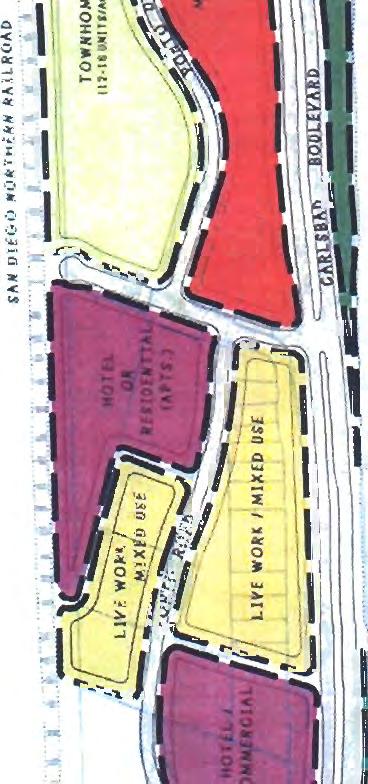
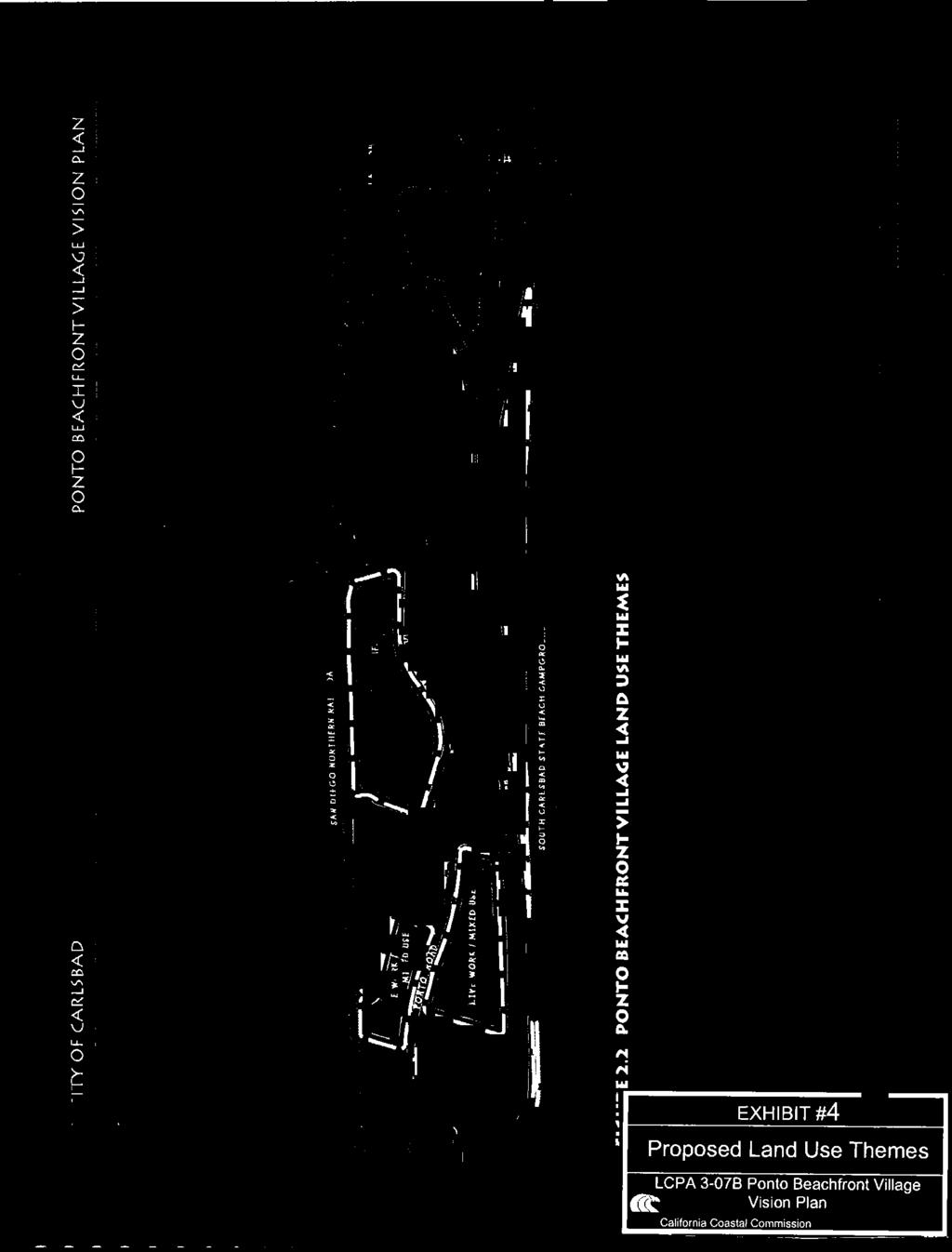
2 Carlsbad LCPA 3-07B/RF Ponto Beachfront Village Vision Plan Page 2 Vision Plan" in the certified Local Coastal Program. The City intends for the Ponto Beachfront Village Vision Plan (Vision Plan) to provide guidance for development of the Ponto area (ref. Exhibits #1, 4). The plan presents goals and objectives for development, and provides an implementation strategy and design guidelines for the projects which will implement the vision. The Vision Plan is intended for use by prospective developers and their consultants, City of Carlsbad staff, and those performing design review on individual projects. The conceptual plan contains a level of detail necessary to visually depict the desired land uses, circulation, and major design components; however, it is recognized that actual development site plans will change. The City has expressed numerous goals in the Vision Plan, the most important of which include: Accommodate a balanced and cohesive mix of local and tourist serving commercial, medium- and high-density residential, mixed use, live/work, and open space land use opportunities that are economically viable. Establish a pattern of pedestrian and bicycle accessibility that links the planning areas internally as well as with adjacent existing and planned pedestrian and bicycle facilities. Provide expanded beach access Establish a mixed use district that encourages local and tourist-oriented retail, commercial, recreational, and residential uses The Ponto area is located in the most southwesterly portion of the city near the city's southern entrance along Carlsbad Boulevard. It presently contains older homes and businesses, most of which were developed in the county before the city incorporated. The Ponto Beach area is an approximately 130-acre narrow strip of land, approximately 1/8 mile wide and 1-1/2 miles long, located between Carlsbad Boulevard and the San Diego Northern railroad tracks. Portions of the plan area extend north to Poinsettia Lane and south to La Costa Avenue. The southern boundary includes coastal bluffs that transition to the waters of Batiquitos Lagoon. Approximately 50 of the 130 acres are considered viable for future development. In order to implement the plan, it is necessary for the City to amend its LCP, in the Mello II and West Batiquitos Lagoon/Sammis Properties segments, to incorporate references to the Vision Plan. However, it is important to note that the plan does not include amendments to the Zoning Ordinance, or modifying any existing land use or zoning within the Ponto Beach region. Individual development projects may still require a combination of changes to the certified land use plan and zoning, require the additional review and approval by the Coastal Commission of possible project specific LCP amendments, as well as individual environmental review and permitting.
3 Carlsbad LCPA 3-07B/RF Ponto Beachfront Village Vision Plan Page 3 The appropriate resolution and motion to adopt the revised findings are found below. The findings for denial of the LCP amendment begins on Page 5. PART II. RESOLUTION FOR REVISED FINDINGS The staff recommends the Commission adopt the following resolution and findings. The appropriate motion to introduce the resolution and a staff recommendation are provided just prior to the resolution. I. MOTION: I move that the Commission adopt the following revised findings in support of the Commission s action on July 9, 2009 concerning certification of City of Carlsbad LCP Land Use Plan Amendment No. 3-07B (Ponto Beachfront Vision Plan). Staff recommends a YES vote on the motion. Passage of this motion will result in the adoption of revised findings as set forth in this staff report. The motion requires a majority vote of the members from the prevailing side present at the July 9, 2009 hearing, with at least three of the prevailing members voting. Only those Commissioners on the prevailing side of the Commission s action are eligible to vote on the revised findings. Commissioners Eligible to Vote: Commissioners Achadjian, Blank, Clark, Secord, Mirkarimi, Shallenberger, Wan, and Chairman Neely RESOLUTION TO ADOPT REVISED FINDINGS : The Commission hereby adopts the findings set forth below for City of Carlsbad LCP Land Use Plan Amendment No. 3-07B (Ponto Beachfront Vision Plan) on the grounds that the findings support the Commission s decision made on July 9, 2009 and accurately reflect the reasons for it. PART III. SUGGESTED MODIFICATIONS STAFF NOTE: The Commission s action on July 9, 2009, through denial of the LCP Amendment, effectively removed all of the suggested modifications as recommended by staff, and; as such, they have been removed from the staff report and attached to this revised findings document as Exhibit #3. PART IV. FINDINGS FOR DENIAL OF CERTIFICATION OF THE LCP LAND USE PLAN AMENDMENT A. AMENDMENT DESCRIPTION Recognizing its potential for redevelopment and its prime coastal location across from the state campgrounds and near new single-family neighborhoods, the City of Carlsbad
4 Carlsbad LCPA 3-07B/RF Ponto Beachfront Village Vision Plan Page 4 decided to create a "vision plan" for the area to direct future development in the Ponto area the full vision plan is available online at: With input from property owners, nearby residents, and other interested persons, the Vision Plan was prepared. The City is therefore proposing to amend its certified Land Use Plan, to include a reference to a document titled "Ponto Beachfront Village Vision Plan" in two segments of the certified Local Coastal Program. The City intends for the Vision Plan to provide guidance for development of the Ponto Area (ref. Exhibit #'s 1 & 4). The plan presents goals and objectives for development, and provides an implementation strategy and design guidelines for the projects which will implement the vision. The Ponto Beach area is an approximately 130-acre narrow strip of land, approximately 1/8 mile wide and 1-1/2 miles long, located between Carlsbad Boulevard and the San Diego Northern railroad tracks. Portions of the plan area extend north to Poinsettia Lane and south to La Costa Avenue. The southern boundary includes coastal bluffs that transition to the waters of Batiquitos Lagoon at the southern end. Approximately 50 of the 130 acres are considered viable for future development. The 50 acres (ref. Exhibit #1) consist of the older Ponto area which is also included in the South Carlsbad Coastal Redevelopment area, one small, vacant parcel located within the boundaries of the Poinsettia Properties Specific Plan, and several vacant properties located in the Poinsettia Shores Master Plan. Both the Poinsettia Properties Specific Plan and the Poinsettia Shores Master Plan have been previously reviewed and certified by the Coastal Commission via an amendment to the City's LCP. The intent of the Vision Plan is to create a mixed use, active pedestrian and bicycle oriented area with a strong sense of place, village atmosphere, and unique character of design. Because of its prime location at the southern gateway to the city and across from the beach and campgrounds, it could become a vibrant part of the city, providing amenities for city residents as well as visitors. The Vision Plan breaks up the Ponto area into three sections (ref. Exhibit #4). The northern-most section is comprised of two hotels and a live-work neighborhood. The central portion of the development is comprised of a townhouse neighborhood and a mixed use center with a public recreation component. This is the only portion of the Vision Plan that would have required additional review by the Commission. Currently, this area has an Unplanned Area land use designation. In order to facilitate any type of development in this portion of the Ponto area, an LCP amendment modifying the land use will have to be brought forward to the Commission for review and approval. The southernmost portion of the area is envisioned as a beachfront resort, including both hotel and timeshare units. Both of these would be considered permitted uses based on the
5 Carlsbad LCPA 3-07B/RF Ponto Beachfront Village Vision Plan Page 5 existing land use and zoning, however, this portion of the Vision Plan is adjacent to wetlands, and located between the first coastal road and the sea, and therefore any Coastal Development Permit issued by the City for this location would be appealable to the Coastal Commission. C. NONCONFORMITY OF THE LAND USE PLAN AMENDMENT WITH CHAPTER 3 1. General Findings for Denial The City of Carlsbad is proposing to include by reference a document that includes goals, permitted uses, design guidelines, and collaborative public improvements (utilities, realignment of Coast Highway) for the Ponto Beachfront area. The document, as included in the LCP only by reference, does not supersede or replace any previously approved components of the City's certified LCP, including both land use policies, master plan standards, specific plan standards, or zoning ordinances. The document does, however, include additional development standards and goals for the Ponto Beach area. This area is west of Interstate-5, and east of Coast Highway, located directly inland of South Carlsbad State Beach. The Vision Plan separates the Ponto Beachfront area into three regions. The northernmost region includes three major land uses: Live-work mixed use development, Hotel/Commercial, and Hotel or Residential uses, these recommended land uses are all consistent with the underlying land use designations: Medium-High Residential/Travel/Recreational Commercial, Travel/Recreational Commercial, and Medium High Residential respectively (ref. Exhibit #5). The central portion of the Vision Plan includes mixed uses and townhome developments as the recommended uses. The existing land use designation carries a Non-Residential Reserve (NRR) General Plan designation, and is considered an "Unplanned Area" (ref. Exhibit #5). The southern portion of the area includes a large scale Resort Hotel. This use has been identified at this location in the two previous Master Plans approved for this area (Batiquitos Lagoon Educational Park and Poinsettia Shores Master Plans). The general Vision Plan promotes a diverse mix of land uses, some of which are visitor serving and thus can be considered high priority. If future development follows the Vision Plan, there will be an addition of three hotels, a comprehensive trail system, and potential commercial tourist uses on this 50-acre coastal area. Again, the Ponto Beachfront Village Vision Plan does not change any land use designations or underlying zoning, and does not supersede the previously approved Master Plans/Specific Plans; all previously approved policies remaining relevant. The new Vision Plan will be used solely as a guidance document for the City and developers to consider appropriate types of development in this area. That being said, a number of concerns remain regarding some of the recommendations included in the Vision Plan.
6 Carlsbad LCPA 3-07B/RF Ponto Beachfront Village Vision Plan Page 6 There are seven six primary concerns raised for the Ponto Beachfront Village Vision Plan: The primary concern relates to the City s identification of preferred development types on land that currently contains no certified land use or zoning designations. Additional concerns include llack of low cost visitor-serving uses, potential impacts to wetlands, mass transit amenities, landscaping, geological setbacks, and associated City projects. 2. Specific Findings for Denial A. Identified Development on Unplanned Lands Again, the primary concern associated with the proposed vision plan is that it identifies, and lists a specific type of development (townhomes and mixed use) for an area that is currently unplanned. The area once carried a specific land use and zoning designation; however, through a previous Commission action, those designations were removed. Thus, identifying development types should only be determined after land use and zoning designations have been re-designated and then approved by the City and the Coastal Commission. While a possible interpretation of the City's adoption of this Vision Plan might be to conclude that the City wants to designate uses in this area now, City representatives have specifically indicated this is not the case and the Vision Plan does call for a future LCP amendment to define permitted uses. To the general reader, this can be confusing. In addition, if the City had indicated that it was seeking to identify permitted uses at this time, the Commission would reject such proposed uses because there has been no evidence presented that would support the elimination of these areas for some lower cost overnight accommodations or public recreational amenities in the future. The Commission's past action of the Poinsettia Shores Master Plan specifically called for such an assessment, and none has been submitted to date. The concerns related to the lack of lower cost overnight accommodations in Area F (ref. Exhibit #7) are further discussed in the findings later. Historically, the previously certified Master Plan for this location that was included in the City s original LCP in 1985 designated this site for Travel Service Commercial. In 1996, the Poinsettia Shores Master Plan was certified as part of the City's LCP, and replaced the land use designation as an "Unplanned Area." The language in the Poinsettia Shores Master Plan, for this location, "Area F," is listed below: Planning Area F - Planning Area F is located at the far northwest corner of the Master Plan area west of the AT&SF Railroad Right-of-way. This Planning Area has a gross area of 11 acres and a net developable area of 10.7 acres. Planning Area F carries a Non-Residential Reserve (NRR) General Plan designation. Planning Area F is an "unplanned" area, for which land uses will be determined at a later date, when more specific planning is carried out for areas west of the railroad right-of-way. A future Major Master Plan Amendment will be required prior to
7 Carlsbad LCPA 3-07B/RF Ponto Beachfront Village Vision Plan Page 7 further development approvals for Planning Area F, and shall include an LCP Amendment with associated environmental review, if determined necessary. The intent of the NRR designation is not to limit the range of potential future uses entirely to non-residential, however, since the City's current general plan does not contain an "unplanned" designation, NRR was determined to be appropriate at this time. In the future, if the Local Coastal Program Amendment has not been processed, and the City develops an "unplanned" General Plan designation, then the site would likely be redesignated as "unplanned." Future uses include, but are not limited to: commercial, residential, office, and other uses, subject to future review and approval. The concern with identifying a specific type of land use for this area is by doing so the City is inadvertently sending a message to potential developers that 1) the identified development (townhouses) is the primary type of use the City will support, or 2) that development type is consistent with the current land use and zoning designations. Neither of those assumptions is correct. As the previously certified Poinsettia Shores Master Plan states, any type of development at this location would first require an LCP amendment to establish the land use and zoning, which would have to be certified by both the City and the Coastal Commission. Additionally, the Master Plan further states that some component of the development at this location must consider the need for the provision of lower cost accommodations or recreational facilities. Potential developers could interpret the Vision Plan as establishing that a townhouse development at this location would be considered a high-priority use. As discussed, this area was first designated for Travel Service Commercial and then later as an unplanned area. While residential use is one of the land uses listed for this area in the Poinsettia Shores Specific Plan, it may not be the most appropriate designation. As previously stated, the project will at least need to consider the incorporation of some kind of lower cost accommodations, and any proposed zoning designation for the site will have to be found consistent with the policies contained in the Poinsettia Shores Master Plan. Furthermore, the standard of review for any change to the current land use designation is the Coastal Act, and thus will also have to be found consistent with all its applicable policies. Recently, the Commission has become concerned with the lack of lower-cost accommodations statewide. Thus, the establishment of a residential land use at this location may not be what is ultimately determined to be certified as consistent with the Poinsettia Shores Master Plan, or the Coastal Act. An additional concern of the Commission is that if the proposed Vision Plan is approved by the Commission, and thus becomes a certified component of the City s LCP, then when the City comes forward with an LCP amendment to identify and certify land use and zoning designations at this location, the Commission might feel obligated to approve a residential land use designation, even though such a land use might not be consistent with Chapter 3. A more suitable approach would be for the City to first process an LCP amendment certifying the land use and zoning for this site, and then certify the Ponto Beachfront
8 Carlsbad LCPA 3-07B/RF Ponto Beachfront Village Vision Plan Page 8 Vision Plan as part of its LCP. Therefore, as this time, the project is premature and shall be rejected. BA. High-Priority Uses - Lower Cost Visitor Accommodations in "Area F" The Coastal Act has numerous policies promoting public access to the beach and state: Section In carrying out the requirement of Section 4 of Article X of the California Constitution, maximum access, which shall be conspicuously posted, and recreational opportunities shall be provided for all the people consistent with public safety needs and the need to protect public rights, rights of private property owners, and natural resource areas from overuse. Section Lower cost visitor and recreational facilities shall be protected, encouraged, and, where feasible, provided. Developments providing public recreational opportunities are preferred. The commission shall not: (1) require that overnight room rentals be fixed at an amount certain for any privately owned and operated hotel, motel, or other similar visitor-serving facility located on either public or private lands; or (2) establish or approve any method for the identification of low or moderate income persons for the purpose of determining eligibility for overnight room rentals in any such facilities. Section Oceanfront land suitable for recreational use shall be protected for recreational use and development unless present and foreseeable future demand for public or commercial recreational activities that could be accommodated on the property is already adequately provided for in the area. Section The use of private lands suitable for visitor-serving commercial recreational facilities designed to enhance public opportunities for coastal recreation shall have priority over private residential, general industrial, or general commercial development, but not over agriculture or coastal-dependent industry. The City of Carlsbad has included a policy directly addressing the Ponto Beach area, and its future uses, and states: Mello II Policy 6-9
9 Carlsbad LCPA 3-07B/RF Ponto Beachfront Village Vision Plan Page 9 The South Carlsbad State Beach Campground should be considered for conversion to a day use beach and upland park if other adequate campground facilities can be developed nearby. Mixed use development (i.e. residential and recreational-commercial) shall be permitted by right on properties fronting Carlsbad Boulevard across from South Carlsbad State Beach (See exhibit 4.9, Page 76). This policy applies only where not in conflict with the agricultural policies of the LCP. As stated above, Area F of the Master Plan is currently designated as an unplanned, area and there is no certified land use established. In addition, the previously certified Master Plan included language to protect and provide some kind of lower-cost accommodations at this site. Thus tthe second primary concern raised is also associated with the central segment of the Vision Plan (ref. Exhibit #'s 4, 5, 7). At this location, recommended uses include townhomes and mixed-use developments. In the mixed use area, ground floor uses are required to be retail or service type uses that generate pedestrian traffic, while office or multi-family residential uses may be located on the upper floors. Some non-retail may occupy the ground floors but is limited to a community amenity such as arts/nature/activities center. In the townhouse portion of the segment, the permitted uses are limited to multiple dwelling structures, and accessory buildings. The concern raised is that this area is designated "Unplanned" in the LUP and the Vision Plan does not replace this existing designation, thus; no specific uses should be required, as that would be inconsistent with the applicable LUP designation. While a possible interpretation of the City's adoption of this Vision Plan might be to conclude that the City wants to designate uses in this area now, City representatives have specifically indicated this is not the case and the Vision Plan does call for a future LCP amendment to define permitted uses. To the general reader, this can be confusing. In addition, if the City had indicated that it was seeking to identify permitted uses at this time, the Commission would reject it because there has been no evidence presented that would support the elimination of these areas for some lower cost overnight accommodations or public recreational amenities in the future. The Commission's past action of the Poinsettia Shores Master Plan specifically called for such an assessment and none has been submitted to date. As further background, the Master Plan for this location that was certified during initial review of the City's LCP in 1985 designated this site for Travel Service Commercial. In 1996, the Poinsettia Shores Master Plan was certified as part of the City's LCP, and replaced the land use designation as an "Unplanned Area." In an attempt to maintain a lower-cost visitor-serving component at this location the Commission, through a suggested modification, required language within the Master Plan that would serve to protect this type of use. The language in the Poinsettia Shores Master Plan, for this location, "Area F," is listed below:
10 Carlsbad LCPA 3-07B/RF Ponto Beachfront Village Vision Plan Page 10 Planning Area F - Planning Area F is located at the far northwest corner of the Master Plan area west of the AT&SF Railroad Right-of-way. This Planning Area has a gross area of 11 acres and a net developable area of 10.7 acres. Planning Area F carries a Non-Residential Reserve (NRR) General Plan designation. Planning Area F is an "unplanned" area, for which land uses will be determined at a later date, when more specific planning is carried out for areas west of the railroad right-of-way. A future Major Master Plan Amendment will be required prior to further development approvals for Planning Area F, and shall include an LCP Amendment with associated environmental review, if determined necessary. The intent of the NRR designation is not to limit the range of potential future uses entirely to non-residential, however, since the City's current general plan does not contain an "unplanned" designation, NRR was determined to be appropriate at this time. In the future, if the Local Coastal Program Amendment has not been processed, and the City develops an "unplanned" General Plan designation, then the site would likely be redesignated as "unplanned." Future uses include, but are not limited to: commercial, residential, office, and other uses, subject to future review and approval. As previously discussed, in 1996, the Poinsettia Shores Master Plan was certified as part of the City's LCP, and replaced the land use designation as an "Unplanned Area." In an attempt to maintain a lower-cost visitor-serving component at this location, the Commission, through a suggested modification, required language within the Master Plan that would serve to protect this type of use. The language in the Poinsettia Shores Master Plan, for this location, "Area F," included: As part of any future planning effort, the City and Developer must consider and document the need for the provision of lower cost accommodations or recreational facilities (i.e. public park) on the west side of the railroad. [Emphasis added] Furthermore, tthe Ponto Beachfront Village Vision Plan, as proposed by the City, includes some similar language in its introduction, stating: In the "Unplanned Area" of Ponto, which roughly corresponds to the vacant land area north of Avenida Encinas, specific planning efforts are required. The intent is not to limit uses to entirely non-residential. Future uses could include commercial, residential, office and others. Consider the need for lower cost visitor or recreational facilities on west side of the rail road tracks. [Emphasis Added] The two sets of language are similar; however, there is a distinct difference. The Poinsettia Shores Master Plan area includes "lower cost accommodations" in the language and the Vision Plan does not. Furthermore, the Vision Plan does not list any type, including lower cost visitor accommodations, as a permitted use in this area. The need for lower cost accommodations has been well documented by the Commission, and is promoted in Sections 30210, 30213, 30221, and of the Coastal Act. The
11 Carlsbad LCPA 3-07B/RF Ponto Beachfront Village Vision Plan Page 11 removal of the above stated language, including removal of lower cost accommodations as a "permitted use," is inconsistent with the Coastal Act. Moreover, of the three areas within the Vision Plan recommended for visitor accommodations, none contain a lower cost component, or a lower cost accommodations recommendation. The Ponto Beachfront area is an area that could be considered as a high-priority location for lower cost overnight accommodations. While located across the street from a State Park (South Carlsbad State Park) containing camping facilities, during peak summer months, the campground is consistently at capacity. Developing additional lower cost accommodations such as a youth hostel would further promote budget-minded travelers to this location. Moreover, Policy 6-9 in the Mello II Segment of the City's certified land use plan, states that the South Carlsbad State Beach should be converted to day use. If at any time in the future, this State Beach campground is converted to day use sites, the market and the need for low cost overnight accommodations will be significantly amplified. Thus the Vision Plan, as proposed by the City, cannot be found consistent with the Coastal Act. CB. Potential Impacts to Wetlands The Coastal Act has numerous policies that serve to protect marine based biological resources and state: Section Marine resources shall be maintained, enhanced, and where feasible, restored. Special protection shall be given to areas and species of special biological or economic significance. Uses of the marine environment shall be carried out in a manner that will sustain the biological productivity of coastal waters and that will maintain healthy populations of all species of marine organisms adequate for longterm commercial recreational, scientific, and educational purposes. Section The biological productivity and the quality of coastal waters, streams, wetlands, estuaries, and lakes appropriate to maintain optimum populations of marine organisms and for the protection of human health shall be maintained and, where feasible, restored through, among other means, minimizing adverse effects of waste water discharges and entrainment, controlling runoff, preventing depletion of ground water supplies and substantial interference with surface water flow, encouraging waste water reclamation, maintaining natural vegetation buffer areas that protect riparian habitats, and minimizing alteration of natural streams. Section 30240
12 Carlsbad LCPA 3-07B/RF Ponto Beachfront Village Vision Plan Page 12 (a) Environmentally sensitive habitat areas shall be protected against any significant disruption of habitat values, and only uses dependent on those resources shall be allowed within those areas. (b) Development in areas adjacent to environmentally sensitive habitat areas and parks and recreation areas shall be sited and designed to prevent impacts which would significantly degrade those areas and shall be compatible with the continuance of those habitat and recreation areas. The City of Carlsbad Mello Segment Land Use Plan also contains policies pertaining to sensitive habitat that state: Mello II Policy Environmentally Sensitive Habitat Areas (ESHA) Pursuant to Section of the California Coastal Act, environmentally sensitive habitat areas, as defined in Section of the Coastal Act, shall be protected against any significant disruption of habitat values, and only uses dependent on those resources shall be allowed within those areas. Mello II Policy Wetlands Pursuant to California Public Resources Code Section and Title 14, California Code of Regulations Section (b), 'wetland' means lands within the coastal zone, which may be covered periodically or permanently with shallow water and include saltwater marshes, freshwater marshes, open or closed brackish water marshes, swamps, mudflats, and fens. Wetland shall include land where the water table is at, near, or above the land surface long enough to promote the formation of hydric soils or to support the growth of hydrophytes, and shall also include those types of wetlands where vegetation is lacking and soil is poorly developed or absent as a result of frequent and drastic fluctuations of surface water levels, wave action, water flow, turbidity or high concentrations of salts or other substances in the substrate. A preponderance of hydric soils or a preponderance of wetland indicator species shall be considered presumptive evidence of wetland conditions. Wetlands shall be delineated following the definitions and boundary descriptions in Section of the California Code of Regulations. [ ] Mello II Policy Buffers and Fuel Modification Zones Buffers shall be required between all preserved habitat area and development. Minimum buffer widths shall be provided as follows: a. 100 ft. for wetlands b. 50 ft. for riparian areas
13 Carlsbad LCPA 3-07B/RF Ponto Beachfront Village Vision Plan Page 13 c. 20 ft. for all other native habitats [ ] West Batiquitos Lagoon/Sammis Properties Policy 3 - Environmentally Sensitive Habitats (1) Batiquitos Lagoon Special Treatment Overlay - The wetlands as defined and determined by CDFG and FWS shall be constrained from development. Pursuant to Section (c) (Public Resources Code) any alteration of the wetlands shall be limited to minor incidental public facilities, restorative measures, and nature studies. Furthermore, any alteration of the wetlands must be approved by the City of Carlsbad and the Coastal Commission. The latter because it will retain Coastal Development Permit jurisdiction. In addition, any wetland alteration will require federal approval through an Army Corps of Engineers (COE) permit. (2) Wetlands Buffer - The Lagoon Special Treatment Overlay shall include a buffer area outside the wetlands boundary as mapped by CDFG and FWS. The buffer shall be of sufficient width (minimum 100 feet unless approved by the Coastal Commission or its successor as part of the Coastal Development Permit) so as to provide a transition habitat as well as provide a protective area to reduce possible disruptive impacts to the lagoon's wildlife and habitats. No development shall occur within the wetlands buffer except for the lateral public access trail described in Policy A1C above. The third second significant concern associated with the proposed Vision Plan relates to potential impacts to wetlands. The Coastal Act as well as the City's certified Land Use Plan, contains several policies protecting wetlands. These policies prohibit impacts to wetlands associated with private development. The proposed Vision Plan does include language protecting "jurisdictional" wetland habitats and makes reference to a biological survey/report completed for the area. The biological report identified areas of jurisdictional wetlands, as defined by the US Army Corps of Engineers, and California Department of Fish and Game's "three parameter method." The three parameter method requires that all three of the common indicators of wetland habitat (hydric soils, hydrophytes, and the presence of surface water or saturated substrate at some time during each year) be present. However, the Coastal Act employs the "one parameter method," and therefore, only requires that one of these common wetland indicators be present at any given time. The discrepancy between the two methods usually results in drastically dissimilar wetland delineations. This would be further exacerbated when attempting to determine an adequate buffer area. Without surveying the potential wetland habitats using the methodology endorsed by the Commission, impacts to wetlands, both direct and indirect, may be caused in this area, inconsistent with the Coastal Act. DC. Use of Mass Transit Facilities The Coastal Act Section pertains to transit and states:
14 Carlsbad LCPA 3-07B/RF Ponto Beachfront Village Vision Plan Page 14 Section New Development shall: (1) Minimize risk to life and property in areas of high geologic, flood, and fire hazard (2) Assure stability and structural integrity, and neither create nor contribute significantly to erosion, geological instability, or destruction of the site or surrounding area or in any way require the construction of protective devices that would substantially alter natural landforms along bluffs and cliffs (4) Minimize energy consumption and vehicle miles traveled [Emphasis added] The City of Carlsbad's Mello II land segment, Policy 7-9 directly relates to mass transit facilities on Carlsbad Boulevard and states: Mello II Policy 7-9 South Carlsbad State Beach: Parking Parking facilities are entirely inadequate in the vicinity of the South Carlsbad State Beach. To remedy this problem, the 20-acre site (APN ) located between Carlsbad Boulevard and the railroad at the junction of Palomar Airport Road shall be developed for parking facilities of approximately 1,500 spaces. When this facility becomes heavily utilized, jitney service should be initiated between the parking area and designated points along Carlsbad Boulevard. The Ponto Beachfront Village Vision Plan includes numerous improvements associated with maximizing pedestrian- and bicycle-oriented travel. Bikes lanes and walking paths are an integral component of the Vision Plan. Both of these potential improvements would promote people getting out of their cars, thus reducing vehicle miles driven, consistent with Section of the Coastal Act. However, the Vision Plan fails to address the potential linkage to mass transit, or the incorporation of ancillary mass transit uses. The Ponto Area is located in close proximity to Interstate-5, the Pacific Coast Highway/Carlsbad Boulevard, and the Poinsettia Rail Station, thus opportunities to link residential, commercial and recreational developments to mass transit should be promoted. Furthermore, Mello II Policy 7-9, requires the construction of a 1,500 space parking lot to be developed just a few miles north of the Ponto region. The policy further requires that when this facility becomes heavily utilized, "jitney service", a multipassenger public transportation vehicle, should be initiated between the parking area and designated points along Carlsbad Boulevard. The Vision Plan does not incorporate shuttle drop-off points or bus stops. The Vision Plan does not recommend that visitor accommodations, or retail/commercial developments provide transit information to visitors. No signage for bus stops or travel
15 Carlsbad LCPA 3-07B/RF Ponto Beachfront Village Vision Plan Page 15 linkages are proposed. The Ponto Beachfront Area is located in close proximity to visitor destinations such as Legoland, the Flower Fields, and the biannual Village Street Fair in downtown Carlsbad, resulting in a large potential for mass transit use by visitors. Thus, while the plan does promote pedestrian and bicycle travel, it fails to adequately promote the use of mass transit, inconsistent with section of the Coastal Act and Mello II Policy 7-9. ED. Landscaping Section Marine resources shall be maintained, enhanced, and where feasible, restored. Special protection shall be given to areas and species of special biological or economic significance. Uses of the marine environment shall be carried out in a manner that will sustain the biological productivity of coastal waters and that will maintain healthy populations of all species of marine organisms adequate for longterm commercial recreational, scientific, and educational purposes. Section The biological productivity and the quality of coastal waters, streams, wetlands, estuaries, and lakes appropriate to maintain optimum populations of marine organisms and for the protection of human health shall be maintained and, where feasible, restored through, among other means, minimizing adverse effects of waste water discharges and entrainment, controlling runoff, preventing depletion of ground water supplies and substantial interference with surface water flow, encouraging waste water reclamation, maintaining natural vegetation buffer areas that protect riparian habitats, and minimizing alteration of natural streams. Section (a) Environmentally sensitive habitat areas shall be protected against any significant disruption of habitat values, and only uses dependent on those resources shall be allowed within those areas. (b) Development in areas adjacent to environmentally sensitive habitat areas and parks and recreation areas shall be sited and designed to prevent impacts which would significantly degrade those areas and shall be compatible with the continuance of those habitat and recreation areas. The City of Carlsbad also has included policies for the protection of sensitive habitat that state: Mello II Policy Environmentally Sensitive Habitat Areas (ESHA)
16 Carlsbad LCPA 3-07B/RF Ponto Beachfront Village Vision Plan Page 16 Pursuant to Section of the California Coastal Act, environmentally sensitive habitat areas, as defined in Section of the Coastal Act, shall be protected against any significant disruption of habitat values, and only uses dependent on those resources shall be allowed within those areas. Mello II Policy Invasive Plants The use of invasive plant species in the landscaping for developments such as those identified in Table 12 of the HMP shall be prohibited. West Batiquitos Lagoon/Sammis Properties Policy 5 - Landscaping In order to guard against introduction of any species which are inherently noxious to or incompatible with adjacent lagoon habitat, drought tolerant plants and native vegetation shall be used in areas of proximity to the wetland, to the maximum extent feasible. The Vision Plan includes a list of the types of landscaping recommended for developments within the Ponto Region. Mexican Fan Palm is one of the listed types of promoted vegetation. However, the California Native Plant Society lists Mexican Fan Palms as an invasive species. Coastal Act section protects environmentally sensitive habitat areas and requires that they be protected against significant disruption. In addition, Policy 5 of the West Batiquitos Lagoon/Sammis Properties (a previously approved segment of the Land Use Plan) states: In order to guard against introduction of any species which are inherently noxious to or incompatible with adjacent lagoon habitat, drought tolerant plants and native vegetation shall be used in areas of proximity to the wetland, to the maximum extent feasible. By allowing invasive species to be included in the recommended plant palette, the City risks that these species will become established near the lagoon and other areas with sensitive habitat, causing significant disruption in the health of these native habitat areas. The Vision Plan does include language that promotes the planting of native habitat, but without prohibiting the invasive species, the potential for impacts to sensitive habitats is significant, inconsistent with Section of the Coastal Act. FE. Geological Setbacks The Coastal Act Section pertains to geological setbacks and bluff stability and states: Section New Development shall:
17 Carlsbad LCPA 3-07B/RF Ponto Beachfront Village Vision Plan Page 17 (1) Minimize risk to life and property in areas of high geologic, flood, and fire hazard (2) Assure stability and structural integrity, and neither create nor contribute significantly to erosion, geological instability, or destruction of the site or surrounding area or in any way require the construction of protective devices that would substantially alter natural landforms along bluffs and cliffs (4) Minimize energy consumption and vehicle miles traveled The southern portion of the Ponto Area is bounded by a coastal bluff transitioning to Batiquitos Lagoon. Both previously certified Master Plans for this area (Batiquitos Lagoon Educational Park, and Poinsettia Shores) included that there would be a geological setback required to separate and protect the coastal bluffs from development. A 45 foot minimum setback was certified as a part of the Poinsettia Shores Master Plan. The Environmental Impact Report (EIR) includes a number of options for setbacks and open space areas associated with these coastal bluffs. The City of Carlsbad certified the EIR with the incorporation of an increased blufftop setback. This option requires a structural setback of generally 75 feet from the bluff edge, with only trails and other lowimpact developments such as signage and benches to be allowed in this setback. However, the Vision Plan fails to identify a minimum geological setback or permitted development within the setbacks for the area closest to the lagoon bluffs. In addition, the City's Master Plan only requires a 45 foot setback. Thus, the EIR considered a 75 foot setback, the Master Plan requires a 45 foot setback, and the Vision Plan is silent with respect to a numerical setback. Further, it is not possible at this time to guarantee that even the 75 foot setback will still be considered adequate when an actual project comes forward for review. The inconsistencies in the different setback requirements and the lack of language requiring a site-specific analysis of geological issues result in potential impacts to geological stability, inconsistent with Section of the Coastal Act. GF. City Projects The Coastal Act, Section 30250, addresses impacts associated with public services and states: Section New residential, commercial, or industrial development, except as otherwise provided in this division, shall be located within, contiguous with, or in close proximity to, existing developed areas able to accommodate it or, where such areas are not able to accommodate it, in other areas with adequate public services and where it will not have significant adverse effects, either individually or cumulatively, on coastal resources. The City of Carlsbad Mello II Segment Policy addressing impacts to sensitive habitat and states:
18 Carlsbad LCPA 3-07B/RF Ponto Beachfront Village Vision Plan Page 18 Mello II Policy Environmentally Sensitive Habitat Areas (ESHA) Pursuant to Section of the California Coastal Act, environmentally sensitive habitat areas, as defined in Section of the Coastal Act, shall be protected against any significant disruption of habitat values, and only uses dependent on those resources shall be allowed within those areas As previously stated, because the implementation of the Vision Plan will result in a much higher density of development than currently exists, upgrades to infrastructure, utilities, and flow of traffic were also considered by the Vision Plan. As part of this process, the City reviewed the realignment of Coast Highway/Carlsbad Boulevard and the relocation of utilities. The City should, however, look at the upgraded infrastructure requirement cohesively instead of improving them on a piece-meal basis. However, the goals for upgraded infrastructure within the Vision Plan fail to protect impacts to coastal resources associated with such projects. The Vision Plan does indicate that the highway realignment will result in impacts to coastal sage scrub and the need for mitigation. It does not, however, include that the impacts should be minimized to the extent practicable, the required mitigation ratio, nor does the plan require mitigation to be located in the coastal zone. Further, while the plan includes three alternatives for alignment, and recommends one specific alternative, it does not provide the opportunity to select a different alternative, or modify the realignment to a location not included in the listed alternatives. Again, it is unclear what the time scale will be for these projects to be completed, and, as such, circumstances may change between the certification of the Vision Plan, and the projects' completion. Further, the proposed utility upgrades, including sewer, gas fuel lines, storm drains, and dry utilities do not include language that would protect any coastal resources that presently exist or that may exist in the future, from potential impacts. While the City may legitimately feel that the other policies in the City's certified land use plans would be applicable and would address possible impacts, the adoption of the Vision Plan without clarifying language would be misleading. HG. Conclusions In conclusion, the Commission finds that the Ponto Beachfront Village Vision Plan will result in significant and widely varying improvements to coastal access. Such improvements include public pedestrian and bicycle trails, three proposed hotel developments, shops, restaurants, a potential nature center, artist studios, and mixed uses resulting in high-density developments promoting alternative transit. However, some concerns regarding the determination of preferred land uses in an unplanned area, the lack of provision of lower-cost accommodations and recreational uses, impacts to wetlands, lack of linkage to mass transit opportunities, landscaping, geological setbacks, and City projects remain. All of these oversights could result in impacts to public access and recreation and other coastal resources and, therefore, the Vision Plan, as submitted, is therefore inconsistent with the Coastal Act, and therefore, shall be denied as submitted.
19 Carlsbad LCPA 3-07B/RF Ponto Beachfront Village Vision Plan Page 19 PART V. FINDINGS FOR APPROVAL OF THE CITY OF CARLSBAD LAND USE PLAN AMENDMENT, IF MODIFIED As previously stated, the Ponto Beachfront Village Vision Plan, as proposed by the City raises six primary concerns. These concerns include: lack of lower cost visitor serving uses, impacts to wetlands, mass transit amenities, landscaping, geological setbacks, and proposed City projects. The Commission has included several suggested modifications. Only with these modifications, the Vision Plan can be found consistent with the Coastal Act. A. High-Priority Uses - Lower Cost Accommodations in "Area F" The primary concern raised by the City's Vision Plan is associated with the central portion of the Ponto Beachfront area proposed for townhome and mixed-use developments. The area is currently designated and zoned as an "Unplanned Area". However, the Vision Plan recommends two distinct uses on the site, and lists the associated permitted developments. The history at this location is that it was previously designated for visitor serving uses (Batiquitos Lagoon Educational Park Master Plan). Subsequently, the Poinsettia Shore Master Plan then redesignated the area as an "unplanned area" with the stipulation that the City and Developer must consider and document the need for the provision of lower cost accommodations or recreational facilities (i.e. public park) on the west side of the railroad. The Vision Plan includes that development must be consistent with the Poinsettia Shores Master Plan; however, it includes no discussion of lower cost accommodations. The Commission has therefore included nine modifications to address this concern. Suggested Modification #5 adds lower cost accommodations, such as a youth hostel, to the list of visitor-serving uses that are included as a general use recommended in the Ponto Beachfront area. Currently, the language simply states that hotel/motel and restaurant uses should be established. As modified, a mix of low-, moderate-, and higher cost accommodations are included and lower cost accommodations are encouraged. The second related Suggested Modification #6, modifies a visual rendering of the Mixed Use Center to include a note that the land use has not been designated at this site; and, as such, a Local Coastal Program amendment will be required with any proposed development. The note goes on to state that as part of this planning effort, the provision of lower cost accommodations or recreational uses shall be considered. Suggested Modification #7 mirrors the language of Suggested Modification #6 and is included as a note to the visual rendering for the townhouse development area. Both of these suggested modifications were included to make it clear that while the rendering indicates townhome and mixed-use developments at this location, those use recommendations are not final and further planning work is necessary. In the Vision Plan, various permitted uses associated with the townhome and mixed-use developments are listed. Suggested Modifications #8 and #9 modify the lists of uses from "permitted" to "recommended," given that uses cannot be defined if no land use
20 Carlsbad LCPA 3-07B/RF Ponto Beachfront Village Vision Plan Page 20 designation has been established. Again, these modifications will make it clear that while the Vision Plan includes the types of developments the City is most likely to support, there has been no final land use determination at this point. An additional benefit to these modifications is that higher priority uses (such as a youth hostel, low cost accommodations) must now be considered for potential development, as directed by the Commission previously. Suggested Modifications #14, 16, 19, and 20 add that any proposed development will include the processing of a Local Coastal Program Amendment to the administrative process for proposed development within the "Unplanned Area." Suggested Modifications #14 and #16 further state that any LCP amendment to facilitate development on these sites, will be required to be found consistent with the Poinsettia Shores Master Plan, including the consideration of lower cost accommodation or recreational uses. All of these suggested modifications are intended to make clear to any interested party that the central portion of the Ponto Beachfront Village area does not have a designated land use at this time. The suggested modifications further provide that the policies and standards previously approved within the certified LCP and the Poinsettia Shores Master Plan are still prevailing, and as such the need for low cost accommodations and/or recreational uses at this location must be considered. Therefore, the LCP amendment as modified promotes the opportunity to support broader public access to the coastline, consistent with the Chapter 3 policies of the Coastal Act. B. Impacts to Wetlands Ponto Beach is located immediately north of Batiquitos Lagoon, and contains a previously constructed drainage ditch that may now support wetland indicator species, such that the potential for onsite wetland habitat is high. The proposed Vision Plan includes, by reference, a biological report delineating any potential wetland habitat. The report utilized the three parameter method, consistent with US Army Corps of Engineers (ACOE) and California Department of Fish and Game (CDFG) requirements for determining jurisdictional waters and the presence of wetlands. However, wetlands are determined using a one parameter method in the coastal zone, consistent with the Coastal Act. Therefore, while the report accurately identified wetland habitats for the ACOE and CDFG, it failed to delineate wetlands using standards required by the Coastal Act and its associated regulations. As such, Suggested Modification #'s1, 18, and 21 have been included to address these concerns. Suggested Modification #1 expands on the plan's provisions for the ACOE/CDFG delineations and adds section, "Wetlands as Defined by the California Coastal Act", and includes language describing how wetlands are delineated consistent with the Coastal Act. The modification also requires that additional biological surveys/reports be completed for any proposed development that may include wetland habitats on site, consistent with the Coastal Commission methodology discussed. Suggested Modification #1 also prohibits impacts to wetlands and requires adequate buffering consistent with the City's certified LCP policies for the Mello II and West Batiquitos Lagoon/Sammis Properties segments.
21 Carlsbad LCPA 3-07B/RF Ponto Beachfront Village Vision Plan Page 21 Suggested Modification #18 requires that areas of private development that contain wetlands within the Coastal Commission's original jurisdiction obtain a Coastal Development Permit from the Coastal Commission. Suggested Modification #20 includes that the development located adjacent to the lagoon and south of Avenida Encinas, is in the Coastal Commission's appeals jurisdiction. All three of the modifications will serve to adequately identify, buffer, and therefore protect all wetland habitats located within the Ponto Beachfront area, consistent with the Coastal Act. C. Mass Transit Opportunities The Vision Plan highly promotes and facilitates non-vehicular travel through recommendations for public pedestrian and bike trails throughout the Ponto Beachfront area, connections to the Coastal Rail Trail, and connections to other portions of public trails around Batiquitos Lagoon. However, the Vision Plan fails to incorporate mass transit opportunities into the plan itself. The Ponto Beachfront area is located near Interstate-5, Coast Highway/Carlsbad Boulevard, and the Poinsettia Rail Station. Connections and ancillary facilities should be promoted, given the project's location and it's proximity to already established mass transit services. As such, Suggested Modification #11 adds a new Section to Section 2.3 Circulation System. The new section, 2.3.3, titled "Connection with Mass Transit" provides language that encourages measures to support alternative transit opportunities. Recommendations for bus stops, availability of bus schedules, and shuttle connections to the Poinsettia Train Station are all identified as potential methods to further promote the reduction of vehicular miles traveled, and the increase in use of alternative transportation, consistent with section of the Coastal Act. D. Prohibition of Invasive Species As previously discussed, the Ponto Beachfront Village Vision Plan includes invasive species as recommended landscaping plants. The Ponto Beachfront area is located adjacent to Batiquitos Lagoon. The Vision Plan includes invasive plants in the recommended plant palette, such as the Mexican Fan Palm. Vegetation such as the Mexican Fan Palm often out-competes native lagoon vegetation. As such, three modifications are recommended to be included in the Vision Plan. Suggested Modification #12 includes language that limits permitted landscaping to native or noninvasive plants. Further, the language specifies that the use of native, drought-tolerant species are highly encouraged. Suggested Modification #13 requires that the list of acceptable landscaping plants provided in the Vision Plan update, removing any recommended trees, plants, shrubs, or flowers that are considered invasive by the California Native Plant Society. Suggested Modification #15 mirrors that of Suggested Modification #13, but is located in another section of the Vision Plan where landscaping requirements are also discussed. All of these three suggested modifications will promote the viability of the sensitive habitat located surrounding Batiquitos Lagoon, consistent with Section of the Coastal Act and promote water conservation. E. Geotechnical Setbacks
22 Carlsbad LCPA 3-07B/RF Ponto Beachfront Village Vision Plan Page 22 Coastal lagoon bluffs are located on the southern extent of the area included in the Ponto Beachfront Vision Plan. The Vision Plan includes a large scale resort development in the area closest to the existing lagoon bluffs. Standards approved previously through the certification of the Poinsettia Shores Master Plan include a geological setback of 45' for any development. The City Council, through certification of the Ponto Beachfront Village Vision Plan EIR, approved a design that included a 75' geological setback, and permitted only public trails, benches, signage, and other low impact development within this setback area. The Vision Plan itself is silent on the required setback for the resort development. It is therefore unclear, when reviewing the Vision Plan, whether the standard of review is the Poinsettia Shore Master Plan, (45'), or the certified EIR (75'). Suggested Modification #3 resolved this ambiguity by requiring that all development proposals include a geological setback of at least 75'. The suggested modification further requires that only public trails, benches, signage and other low impact development be permitted within the 75' setback area. The intent of the modification is to make clear that the required setback associated with any future development proposal must be at least 75'. Given that the time line associated with development at this site is unknown, circumstances may change, and along with possible impacts related to sea level rise, the more conservative setback is most consistent with Section of the Coastal Act. F. City Projects During the Vision Plan process, the City also reviewed the realignment of Coast Highway/Carlsbad Boulevard, and the upgrading of existing utilities including sewer, gas, storm drain, and dry utilities. The Vision Plan includes language requiring the City to review these projects cohesively and not on a piece-meal basis. The section addressing these projects includes language and figures identifying the location of the upgraded facilities. The section, titled "Infrastructure," however, fails to include any language that requires impacts to sensitive resources be minimized. As such, Suggested Modification #10 requires that when these projects are ultimately reviewed, the plans ensure the minimization of potential impacts to coastal resources, and the suggested modifications also requires the projects are consistent with the certified Local Coastal Program. By requiring that the projects' be consistent with the certified LCP, not only are impacts required to be minimized, but mitigation values and standards that have already been certified by the Commission as part of this LCP, will be applied to these project. As modified, the Vision Plan can therefore, be found consistent with the Coastal Act. G. Conclusion In conclusion, the City has made a noteworthy effort to create a plan that will promote an increase in public access and amenities, and create a uniform character in the development of one of the last large vacant coastal areas left in the southern California coastal zone. However, six areas of concerns were raised with respect to the Vision Plan's consistency with the Coastal Act. These six concerns have been discussed above, and several suggested modifications have been recommended to address these concerns.
23 Carlsbad LCPA 3-07B/RF Ponto Beachfront Village Vision Plan Page 23 Only with the modifications can coastal resources remain protected to a level consistent with the applicable policies of the Coastal Act. PART VI. CONSISTENCY WITH THE CALIFORNIA ENVIRONMENTAL QUALITY ACT (CEQA) Section of the California Environmental Quality Act (CEQA) exempts local government from the requirement of preparing an environmental impact report (EIR) in connection with its local coastal program. Nevertheless, the Commission is required, in a LCP submittal or, as in this case, a LCP amendment submittal, to find that the approval of the proposed LCP, or LCP, as amended, conforms to CEQA provisions, including the requirement in CEQA section (d)(2)(A) that the amended LCP will not be approved or adopted as proposed if there are feasible alternative or feasible mitigation measures available which would substantially lessen any significant adverse impact which the activity may have on the environment. 14 C.C.R (a), 13540(f), and 13555(b). The Commission finds that approval of the proposed LCP amendment, as submitted, would result in significant impacts under the meaning of the California Environmental Quality Act. However, with the inclusion of the suggested modifications and implementation of the revised land use plan provisions, the adoption would not result in significant impacts to the environment within the meaning of the California Environmental Quality Act. Therefore, the Commission finds that approval of the LCP amendment, as modified, will not result in any significant adverse environmental impacts.specifically, the vision plan identifies specific types of development for an area that is currently designated and zoned unplanned. Additional concerns included lack of low cost visitor-serving uses, potential impacts to wetlands, mass transit amenities, the inclusion of potentially invasive landscaping, inadequate geological setbacks, and concerns associated with specified City projects. Many of these impacts are avoidable, however, the City failed to identify alternatives that would eliminate or minimize the above stated impacts to the maximum extent practicable. The City also failed to identify the mitigation required for such impacts. Therefore, the Commission finds that the proposed vision plan document identified future development plans that cannot be considered the least environmentally damaging feasible alternative and must be denied.
24
25
26
27
28
29
30
31
32
33
34
35
36
37
38
39
40
41


42


43


44
Venice Pumping Plant Dual Force Main Project Draft EIR
 City of Los Angeles 5.9 LAND USE PLANS 5.9.1 Environmental Setting Venice Pumping Plant Dual Force Main Project Draft EIR The Project lies within the bounds of Los Angeles County and the City of Los Angeles.
Planned Development Review Revisions (Project No. PLNPCM )
") Planned Development Review Revisions (Project No. PLNPCM2014-00139) Standard residential development Planned Development Example: Smaller lot sizes than what is allowed to create open space amenity. What
Planned Development Review Revisions (Project No. PLNPCM2014-00139) Standard residential development Planned Development Example: Smaller lot sizes than what is allowed to create open space amenity. What
Gold Line Bus Rapid Transit Transit Oriented Development (BRTOD) Helmo Station Area Plan
 Helmo Station Area Plan") Appendix F Gold Line Bus Rapid Transit Transit Oriented Development (BRTOD) Helmo Station Area Plan Introduction and Purpose of the Plan The Gold Line Bus Rapid Transit facility is an eleven-mile dedicated
Appendix F Gold Line Bus Rapid Transit Transit Oriented Development (BRTOD) Helmo Station Area Plan Introduction and Purpose of the Plan The Gold Line Bus Rapid Transit facility is an eleven-mile dedicated
Glenborough at Easton Land Use Master Plan
 Implementation 114 9.0 IMPLEMENTATION 9.1 OVERVIEW This chapter summarizes the administrative procedures necessary to implement the proposed land use plan, infrastructure improvements, development standards,
6 PORT SYDNEY SETTLEMENT AREA
 Section 6 Port Sydney Page 61 6 PORT SYDNEY SETTLEMENT AREA 6.1 Basis and Principles Village of Port Sydney Waterfront Community Existing Services 6.1.1 Port Sydney is an historic settlement that has developed
3.0 LAND USE PLAN. 3.1 Regional Location. 3.2 Existing Conditions Existing Uses. Exhibit Regional Location Map
 3.0 LAND USE PLAN 3.1 Regional Location The Anaheim Resort Specific Plan (ARSP) area is located in the City of Anaheim, which is 35 miles southeast of downtown Los Angeles and 7 miles northwest of Santa
3.10 LAND USE SETTING PROJECT SITE EXISTING LAND USE DESIGNATIONS AND ZONING. General Plan Land Use Designations.
 This section of the Draft EIR addresses the existing land uses on and adjacent to the project site and discusses the potential impacts of the proposed project on existing land uses. Key issues addressed
CONSERVATION ELEMENT GOALS, OBJECTIVES, AND POLICIES
 CONSERVATION ELEMENT GOALS, OBJECTIVES, AND POLICIES Goal 4 To conserve, manage, appropriately use and protect the natural resources of the City ensuring continued resource availability and environmental
2. INTRODUCTION 2.1 AUTHORITY 2.2 PURPOSE AND INTENT 2.3 SITE LOCATION
 2. INTRODUCTION 2.1 AUTHORITY The City of Gardena initiated and prepared the Artesia Corridor Specific Plan pursuant to the provisions of California Government Code, Title 7, Division 1, Chapter 3, Article
SECTION UNIFIED DEVELOPMENT ORDINANCE SECTION Part 1 Ordinance. ARTICLE 1 Zoning Districts
 SECTION 1-100 UNIFIED DEVELOPMENT ORDINANCE SECTION 1-300 Part 1 Ordinance SECTION 1-100. Introduction. ARTICLE 1 Zoning Districts Crystal Lake strives to maintain a balance of various land uses for a
Urban Planning and Land Use
 Urban Planning and Land Use 701 North 7 th Street, Room 423 Phone: (913) 573-5750 Kansas City, Kansas 66101 Fax: (913) 573-5796 Email: planninginfo@wycokck.org www.wycokck.org/planning To: From: City Planning
Planning Commission Report
 Planning Commission Report To: From: Subject: Planning Commission Meeting: January 6, 2016 Agenda Item: 8-B Planning Commission David Martin, Planning & Community Development Director Introduction to the
4.1 LAND USE AND PLANNING EXISTING CONDITIONS REGULATORY BACKGROUND LAND USES IN THE PLAN AREA SURROUNDING LAND USES
 4.1 LAND USE AND PLANNING This section includes a description of the existing land use plans that apply to the Plan area and a description of existing land uses in the vicinity. It also includes an analysis
Transportation. Strategies for Action
 Transportation A major priority for the Overlake Neighborhood is to develop a multimodal transportation system. To achieve this system, a balance has to be found among travel, circulation and access needs;
GENERAL LAND USE PLAN ELEMENT
 CITY OF Prepared by City of Medford Planning Department 200 South Ivy Street Medford, Oregon 97501 plnmed@ci.medford.or.us James E. Huber, AICP, Planning Director COMPREHENSIVE PLANNING SECTION John Adam,
COASTAL CONSERVANCY. Staff Recommendation June 5, 2008 SAN DIEGO RIVER TRIBUTARY CANYONS PROJECT. File No Project Manager: Megan Johnson
 COASTAL CONSERVANCY Staff Recommendation June 5, 2008 SAN DIEGO RIVER TRIBUTARY CANYONS PROJECT File No. 08-059 Project Manager: Megan Johnson RECOMMENDED ACTION: Authorization to disburse an amount not
SPECIFIC PLAN Requirements
 CITY OF LANCASTER PLANNING DEPARTMENT 44933 Fern Avenue, Lancaster, California 93534 (661) 723-6100 SPECIFIC PLAN Requirements Purpose The purpose of a specific plan is to provide for the logical development
A. WHAT IS A GENERAL PLAN?
 I. Introduction A. WHAT IS A GENERAL PLAN? A general plan is the planning guideline for the future of a city. It contains goals and policies which regulate urban development, the protection of the natural
4. ENVIRONMENTAL IMPACT ANALYSIS 7. LAND USE AND PLANNING
 4. ENVIRONMENTAL IMPACT ANALYSIS 7. LAND USE AND PLANNING 4.7.1 INTRODUCTION The following analysis discusses the consistency of the Proposed Project with the corresponding land use and zoning designations
ADDENDUM TO BIOLOGICAL SCOPING SURVEY REPORT, BOTANICAL SURVEY AND WETLAND DELINEATION
 ADDENDUM TO BIOLOGICAL SCOPING SURVEY REPORT, BOTANICAL SURVEY AND WETLAND DELINEATION FOR AVALON INN (APN 069-241-27 & -04) 1201 & 1211 NORTH MAIN STREET FORT BRAGG, CA MENDOCINO COUNTY prepared for:
I539. Smales 2 Precinct
 I539. Smales 2 Precinct I539.1. Precinct Description The Smales 2 Precinct applies to a 4.8 hectare block of land located on the southern side of Northcote Road and fronting Lake Pupuke, Takapuna. The
Staff Report CONDITIONAL USE
 Staff Report PLANNING DIVISION COMMUNITY & ECONOMIC DEVELOPMENT To: From: Salt Lake City Planning Commission Daniel Echeverria, (801) 535-7165, daniel.echeverria@slcgov.com Date: May 21, 2015 Re: PLNPCM2015-00139
OFFICE CONSOLIDATION SECONDARY PLAN AREA 22 THE BRAMALEA SOUTH INDUSTRIAL SECONDARY PLAN
 OFFICE CONSOLIDATION SECONDARY PLAN AREA 22 THE BRAMALEA SOUTH INDUSTRIAL SECONDARY PLAN November 2010 EXPLANATORY NOTES (Secondary Plan Area 22) General (pertaining to all secondary plan office consolidations)
3. Project Description
 3.1 PROJECT LOCATION The Platinum Triangle (herein after also referred to as the Project Area ) is located at the confluence of the Interstate 5 (I-5 Freeway) and the State Route 57 (SR-57 Freeway), in
CITY OF SEASIDE STAFF REPORT
 Item 12 CITY OF SEASIDE STAFF REPORT TO: FROM: BY: Honorable Mayor and City Council Ray Corpuz, City Manager Diana Ingersoll, Deputy City Manager, Resource Management Services Rick Medina, Senior Planner
Community Development Department Planning Division 1600 First Street + P.O. Box 660 Napa, CA (707)
") Community Development Department Planning Division 1600 First Street + P.O. Box 660 Napa, CA 94559-0660 (707) 257-9530 PLANNING COMMISSION STAFFREPORT December 4, 2014 AGENDA ITEM 8.A. 14-0138; ALTAMURA
Community Development Department Planning Division 1600 First Street + P.O. Box 660 Napa, CA 94559-0660 (707) 257-9530 PLANNING COMMISSION STAFFREPORT December 4, 2014 AGENDA ITEM 8.A. 14-0138; ALTAMURA
BROOKHILL NEIGHBORHOOD MODEL ZONING MAP AMENDMENT PREFACE TO APPLICATION
 BROOKHILL NEIGHBORHOOD MODEL ZONING MAP AMENDMENT PREFACE TO APPLICATION June 15, 2015 Revised: August 1, 2016 I. VISION Brookhill is a proposed community based upon the principles of Albemarle County
DRAFT MAP AMENDMENT FLU 04-4
 DRAFT MAP AMENDMENT FLU 04-4 SW 24 TH AVENUE ROADWAY CORRIDOR The University of Florida participates with the Metropolitan Transportation Planning Organization (MTPO) in its responsibilities for the continuing,
ORDINANCE NO WHEREAS, the recommendations from the Pinellas County Local Planning Agency have been received and considered.
 ORDINANCE NO. 16-55 AN ORDINANCE OF THE COUNTY OF PINELLAS, AMENDING THE FUTURE LAND USE AND QUALITY COMMUNITIES ELEMENT OF THE PINELLAS COUNTY COMPREHENSIVE PLAN TO ADOPT THE CRYSTAL BEACH COMMUNITY OVERLAY;
SPRINGHILL LAKE TRANSIT VILLAGE
 Greenbelt Metro Area Sector Plan - Subarea Design Policies and Guidelines - Springhill Lake Transit Village 113 SPRINGHILL LAKE TRANSIT VILLAGE Residential Neighborhood and Village Center CONCEPT Springhill
Preserve the Flower and Strawberry Fields and Save Carlsbad Taxpayers* Money
 EXHIBIT "A" Preserve the Flower and Strawberry Fields and Save Carlsbad Taxpayers* Money The People of the City of Carlsbad do hereby enact and ordain: 1. Section 1. TITLE 1.1 This measure shall be known
Mark-up of the effect of the proposed Bronte Village Growth Area OPA No.18 on the text of section 24, Bronte Village, of the Livable Oakville Plan
 Mark-up of the effect of the proposed Bronte Village Growth Area OPA No.18 on the text of section 24, Bronte Village, of the Livable Oakville Plan Notes: This document is provided for information purposes
COLVER ROAD INDUSTRIAL CONCEPT PLAN
 COLVER ROAD INDUSTRIAL CONCEPT PLAN A CONCEPTUAL LAND USE AND TRANSPORTATION PLAN FOR TA-4 AN URBAN RESERVE AREA OF THE CITY TALENT City of Talent Adopted by City Council Resolution No., June, 2015 PART
ARTICLE 6: Special and Planned Development Districts
 ARTICLE 6: Special and Planned Development Districts 6-10 Traditional Neighborhood Development (TND) District 6-10.10 Purpose and Intent The Traditional Neighborhood Development (TND) District provides
The transportation system in a community is an
 7 TRANSPORTATION The transportation system in a community is an important factor contributing to the quality of life of the residents. Without a sound transportation system to bring both goods and patrons
Memorandum Planning. Thursday, January 8, 2015
 Memorandum Planning Thursday, January 8, 2015 7.A. To: Coastal Advisory Committee From John Ciampa, Associate Planner Subject: Review Draft Local Coastal Program Copies: James Pechous, City Planner Purpose
17.11 Establishment of Land Use Districts
 17.11 Establishment of Land Use Districts 17.11.010 Purpose. To promote the health, safety, and general welfare of City residents and those who come to South Salt Lake to work, exchange commerce and recreate.
NOTICE OF PREPARATION
 NOTICE OF PREPARATION To: All Interested Parties Subject: Notice of Preparation of an Environmental Impact Report From: City of Petaluma Address: 11 English Street, Petaluma, CA 94952-2610 Contact: Heather
REQUEST Current Zoning: O-15(CD) (office) Proposed Zoning: TOD-M(CD) (transit oriented development mixed-use, conditional)
 (office) Proposed Zoning: TOD-M(CD) (transit oriented development mixed-use, conditional)") Rezoning Petition 2016-117 Zoning Committee Recommendation January 4, 2017 REQUEST Current Zoning: O-15(CD) (office) Proposed Zoning: TOD-M(CD) (transit oriented development mixed-use, conditional) LOCATION
Rezoning Petition 2016-117 Zoning Committee Recommendation January 4, 2017 REQUEST Current Zoning: O-15(CD) (office) Proposed Zoning: TOD-M(CD) (transit oriented development mixed-use, conditional) LOCATION
2040 LUP is a part of the Comprehensive Plan and carries the same legal authority. Economic Challenges
 1.1. Guiding Anchorage s Growth Where will new residents settle over the next two decades? Where will people work, shop, and play? Will there be enough room to grow? How will Anchorage look? Will growth
ORDINANCE WHEREAS, this Ordinance is consistent with the City of Winter Garden Comprehensive Plan; and
 ORDINANCE 17-06 AN ORDINANCE OF THE CITY COMMISSION OF THE CITY OF WINTER GARDEN, FLORIDA, CREATING ARTICLE XIV OF CHAPTER 118 OF THE CITY OF WINTER GARDEN CODE OF ORDINANCES PROVIDING FOR THE EAST PLANT
MEMORANDUM. DATE: March 15, Chairman and Members Community Redevelopment Agency. Leif J. Ahnell, C.P.A., C.G.F.O. Executive Director
 MEMORANDUM DATE: March 15, 2019 TO: FROM: Chairman and Members Community Redevelopment Agency Leif J. Ahnell, C.P.A., C.G.F.O. Executive Director SUBJECT: Camino Square, IDA No. CRP-16-02, located at 171
Planning Commission Staff Report June 5, 2008
 Owner/Applicant Taylor Village Sacramento Investments Partners, LP c/o Kim Whitney 1792 Tribute Road #270 Sacramento, CA 95815 Staff Recommendation Planning Commission Staff Report Project: File: Request:
ADOPTED CAPITAL IMPROVEMENT PROGRAM BUDGET ARROYO PROJECTS
 ADOPTED CAPITAL IMPROVEMENT PROGRAM BUDGET ARROYO PROJECTS HAHAMONGNA FY 212-216 Capital Improvement Program Priority Description Total Estimated Costs Appropriated Through FY 211 Adopted FY 212 FY 213
CITY OF PUYALLUP. Background. Development Services
 CITY OF PUYALLUP Development Services 333 South Meridian Puyallup WA 98371 To: City Council From: Katie Baker, AICP, Planning Division Re: South Hill Neighborhood Plan Adoption Date: (Meeting date: February
Staff Report to the North Ogden City Planning Commission
 Staff Report to the North Ogden City Planning Commission SYNOPSIS / APPLICATION INFORMATION Application Request: Concept review on a legislative application to rezone land located at approximately 1750
Questions for Carlsbad City Council Members and Candidates (July 1, 2016)
") Ponto is Carlsbad s Southern Coastal Gateway Questions for Carlsbad City Council Members and Candidates (July 1, 2016) 1. Are you aware of the 3 proposed developments in Ponto? What are your most important
Ponto is Carlsbad s Southern Coastal Gateway Questions for Carlsbad City Council Members and Candidates (July 1, 2016) 1. Are you aware of the 3 proposed developments in Ponto? What are your most important
City of Tacoma Planning and Development Services
 Agenda Item D-3 City of Tacoma Planning and Development Services To: Planning Commission From: Stephen Atkinson, Associate Planner, Planning Services Division Subject: Land Use Designations - Phase 2 Meeting
RESOLUTION NO
 RESOLUTION NO. 13-35 A RESOLUTION OF THE CITY COUNCIL OF THE CITY OF MALIBU APPROVING GENERAL PLAN AMENDMENT (GPA) NO. 12-001, AMENDMENT TO THE GENERAL PLAN LAND USE ELEMENT AS REQUIRED TO IMPLEMENT THE
City of San Mateo General Plan Circulation Element. Adopted October 18, 2010
 City of San Mateo General Plan Circulation Element. Adopted October 18, 2010 TRANSIT (pp III-20 to III-21) Exhibit A - Item 20 Excerpt from 2010 Downtown Plan Update and enacting Resolution C 3.4: Hillsdale
CHAPTER 7: VISION AND ACTION STATEMENTS. Noble 2025 Vision Statement
 CHAPTER 7: VISION AND ACTION STATEMENTS This chapter presents the vision, policy and action statements that transform the comprehensive planning study, an analysis of Noble s past, future trends and community
Be it enacted by the Town Board of the Town of Guilderland that the following new A (Transit Oriented Development (TOD) District) is adopted:
 District) is adopted:") Local Law No. 4 of 2018 (Adoption of 280-18A (Transit Oriented Development District) Be it enacted by the Town Board of the Town of Guilderland that the following new 280-18A (Transit Oriented Development
Local Law No. 4 of 2018 (Adoption of 280-18A (Transit Oriented Development District) Be it enacted by the Town Board of the Town of Guilderland that the following new 280-18A (Transit Oriented Development
The City of Carlsbad Planning Division A REPORT TO THE PLANNING COMMISSION
 The City of Carlsbad Planning Division A REPORT TO THE PLANNING COMMISSION Item No. 4 Application complete date: N/A P.C. AGENDA OF: December 6, 2017 Project Planner: Carl Stiehl Project Engineer: David
C. Westerly Creek Village & The Montview Corridor
 C. Westerly Creek Village & The VISION Community Vision When the goals of the city are achieved Westerly Creek Village, a distinctive community defined by Montview Boulevard and Westerly Creek, is a strong
4.1.3 LAND USE CATEGORIES
 4.1.3 LAND USE CATEGORIES a. City Center District The City Center District incorporates the existing character and mix of uses in downtown Belmont to encourage redevelopment and new development in keeping
Carlsbad Village Redevelopment Concept Summary of Features
 Carlsbad Village Redevelopment Concept Summary of Features Calthorpe Associates November 5, 2003 The Redevelopment Concept illustrates a vision for the future of Carlsbad Village. The overall vision of
PC RESOLUTION NO
 PC RESOLUTION NO. 14-01-14-02 TENTATIVE TRACT MAP fttm) 17441. REZONE {RZ) 13-003, ARCHITECTURAL CONTROL (AC) 13-003, TREE REMOVAL PERMIT (TRP) 13-052. GRADING PLAN MODIFICATION (GPM) 13-002. CONDITIONAL
1.0 Circulation Element
 5/9/18 1.0 Circulation Element 1.1 Introduction As growth and development occur in Apache County, enhancements to its circulation system will be necessary. With time, more roads will be paved and air and
DEPARTURE FROM DESIGN STANDARDS DDS-586
 The Maryland-National Capital Park and Planning Commission Prince George s County Planning Department Development Review Division 301-952-3530 Note: Staff reports can be accessed at www.mncppc.org/pgco/planning/plan.htm.
SUBJECT: LOCAL GOVERNMENT COMPREHENSIVE PLAN PROPOSED AND ADOPTED AMENDMENT CONSENT AGENDA
 MEMORANDUM AGENDA ITEM #IV.C DATE: APRIL 15, 2019 TO: FROM: COUNCIL MEMBERS STAFF SUBJECT: LOCAL GOVERNMENT COMPREHENSIVE PLAN PROPOSED AND ADOPTED AMENDMENT CONSENT AGENDA Pursuant to the 1974 Interlocal
Department of Community Development. Planning and Environmental Review Division Revised Notice of Preparation
 Department of Community Development Michael J. Penrose, Acting Director Divisions Building Permits & Inspection Code Enforcement County Engineering Economic Development & Marketing Planning & Environmental
NEW CASTLE COUNTY S ZONING DISTRICTS
 NEW CASTLE COUNTY S ZONING DISTRICTS This is general information about New Castle County s zoning districts. The information included is by no means exhaustive or complete. Before designing plans to develop
QUEEN-RIVER SECONDARY PLAN
 34 QUEEN-RIVER SECONDARY PLAN 34. QUEEN RIVER SECONDARY PLAN 1. INTRODUCTION The Queen-River area is approximately 6.4 hectares and is located at the eastern edge of the Downtown as shown on Map 34-1.
Public Review Draft Oceanside Subarea Habitat Conservation Plan/ Natural Communities Conservation Plan
 Oceanside Subarea Habitat Conservation Plan/ Natural Communities Conservation Plan Prepared for City of Oceanside Planning Department 300 N. Coast Highway Oceanside, CA 92054 Prepared by Ogden Environmental
Descriptive Summary of the Comprehensive Plan Amendment
 Applicant City of Virginia Beach Public Hearing October 12, 2016 2016 Comprehensive Plan Amendment Establishing the Historic Seatack & Vicinity Suburban Focus Area (SFA) in Chapter 1, Section 1.3 Agenda
CHAPTER 1. Ms. Guajardo s Class - Central Elementary CH 1 1
 INTRODUCTION CHAPTER 1 Ms. Guajardo s Class - Central Elementary CH 1 1 1.1 SETTING South Centre City is a linear corridor south of Downtown Escondido paralleling Centre City Parkway and South Escondido
LOS ANGELES AIRPORT/EL SEGUNDO DUNES Specific Plan
 LOS ANGELES AIRPORT/EL SEGUNDO DUNES Specific Plan Ordinance No. 167,940 Effective June 28, 1992 TABLE OF CONTENTS MAP Section 1. Section 2. Section 3. Section 4. Section 5. Section 6. Specific Plan Area
EXISTING COMPREHENSIVE PLAN
 EXISTING COMPREHENSIVE PLAN Town Center Land Use Element: V. LAND USE POLICIES Town Center Mercer Island's business district vision as described in "Your Mercer Island Citizen-Designed Downtown" was an
PORT WHITBY COMMUNITY
 PORT WHITBY COMMUNITY SECONDARY PLAN UPDATE COMMUNITY IMPROVEMENT PLAN URBAN DESIGN GUIDELINES September 2015 DRAFT PROPOSED AMENDMENT NUMBER # to the Whitby Official Plan PURPOSE: The intent of this Amendment
Small Area Plan. South Gateway
 Small Area Plan Adopted May 12, 2008 South Gateway Purpose. The South Gateway Small Area Plan defines the City s expectations for the future of the southern entrance to the City at Interstate 85 and Highway
F. The following uses in the HR District: attached single-family dwellings, condominiums, and institutional uses; and
 1102 DESIGN REVIEW 1102.01 PURPOSE AND APPLICABILITY Section 1102 is adopted to provide standards, criteria, and procedures under which design review may be approved. Design review is required for: A.
CITY OF MORRO BAY PUBLIC SERVICES DEPARTMENT 955 SHASTA AVENUE. MORRO BAY, CA
 CITY OF MORRO BAY PUBLIC SERVICES DEPARTMENT 955 SHASTA AVENUE. MORRO BAY, CA 93442 805-772-6261 When is a Permit Required? Implementation Measures For Major Vegetation Removal, Replacement and Protection
TREASURE COAST REGIONAL PLANNING COUNCIL M E M O R A N D U M. To: Council Members AGENDA ITEM 5H
 TREASURE COAST REGIONAL PLANNING COUNCIL M E M O R A N D U M To: Council Members AGENDA ITEM 5H From: Date: Subject: Staff October 17, 2008 Council Meeting Local Government Comprehensive Plan Review Draft
Policies and Code Intent Sections Related to Town Center
 Policies and Code Intent Sections Related to Town Center The Town Center Vision is scattered throughout the Comprehensive Plan, development code and the 1994 Town Center Plan. What follows are sections
STAFF SUMMARY FOR S17-02 SPECIAL USE PERMIT APPLICATION
 APPLICATION SUMMARY Case Number: S17-02 Request: STAFF SUMMARY FOR S17-02 SPECIAL USE PERMIT APPLICATION SUP application in order to develop a convenience food store. Applicant: Property Owner(s): Cindee
WHEREAS, after consideration of the evidence presented at the public hearing on January 14, 2010, the Prince George's County Planning Board finds:
 R E S O L U T I O N WHEREAS, the Prince George s County Planning Board has reviewed DDS-600 requesting a departure for the location of two loading spaces without driveway access along Toledo Terrace in
Master Plan for Preservation and Scenic Conservation (1995)
") 3.2 Master Plan for Preservation and Scenic Conservation (1995) The Master Plan for Preservation and Scenic Conservation was developed under the direction of the Guilford Preservation Alliance in the 1980s
3.2 Master Plan for Preservation and Scenic Conservation (1995) The Master Plan for Preservation and Scenic Conservation was developed under the direction of the Guilford Preservation Alliance in the 1980s
SAN RAFAEL GENERAL PLAN 2040 INTRODUCTION AND OVERVIEW
 SAN RAFAEL GENERAL PLAN 2040 INTRODUCTION AND OVERVIEW Steering Committee Presentation February 14, 2018 Purpose of General Plan Guide land use and development decisions Coordinate transportation, infrastructure,
HALF MOON BAY LOCAL COASTAL PROGRAM. d), JOHN M. St>NGER ASSOCIATES INC S.F.' CA EIOO VISUAL RESOURCES OVERLAY.
, JOHN M. St>NGER ASSOCIATES INC S.F.' CA EIOO VISUAL RESOURCES OVERLAY.") VISUAL RESOURCES OVERLAY Old Downtown Jl&& Scenic Hillsides Ocean Views from Highway 1 HALF MOON BAY LOCAL COASTAL PROGRAM d), JOHN M. St>NGER ASSOCIATES INC S.F.' CA. 94114 EIOO 217 CHAPTER 7: VISUAL
VISUAL RESOURCES OVERLAY Old Downtown Jl&& Scenic Hillsides Ocean Views from Highway 1 HALF MOON BAY LOCAL COASTAL PROGRAM d), JOHN M. St>NGER ASSOCIATES INC S.F.' CA. 94114 EIOO 217 CHAPTER 7: VISUAL
CHAPTER 7: Transportation, Mobility and Circulation
 AGLE AREA COMMUNITY Plan CHAPTER 7 CHAPTER 7: Transportation, Mobility and Circulation Transportation, Mobility and Circulation The purpose of the Transportation, Mobility and Circulation Chapter is to
Chapter 10 IMPLEMENTATION RECOMMENDATIONS
 Chapter 10 IMPLEMENTATION RECOMMENDATIONS The recommended land use plan presented in the previous chapter provides a design for the attainment of the urban and rural development and open space preservation
SANTA BARBARA COUNTY PLANNING COMMISSION Coastal Zone Staff Report for Highway 101: Carpinteria to Santa Barbara Local Coastal Program Amendment
 SANTA BARBARA COUNTY PLANNING COMMISSION Coastal Zone Staff Report for Highway 101: Carpinteria to Santa Barbara Local Coastal Program Amendment Hearing Date: May 2, 2018 Staff Report Date: April 12, 2018
WASHINGTON COUNTY OREGON
 WASHINGTON COUNTY OREGON LONG RANGE PLANNING DIVISION North Bethany Subarea Stream Corridors: Existing Regulations In Oregon, there is a distinct difference between the land use rules that apply in rural
STREAM BUFFERS
 88-415 STREAM BUFFERS 88-415-01 PURPOSE In the Kansas City region and throughout the nation, vegetated stream buffers have been clearly shown to protect stream stability and related infrastructure, improve
Description of Preferred Alternative
 Chapter 2 Description of Preferred Alternative 2.1 Introduction This chapter of the programmatic Sammamish Town Center Sub-area Plan Final EIS provides a more detailed description of the Preferred Alternative
The West Vaughan Employment Area Secondary Plan Policies
 Part 2: The West Vaughan Employment Area Secondary Plan Policies 2.1 General Policies It is the policy of Council: 2.1.1. That the West Vaughan Employment Area (the WVEA), identified on Schedule 1, will
Land Use Amendment in Southwood (Ward 11) at and Elbow Drive SW, LOC
 at and Elbow Drive SW, LOC") 2018 November 15 Page 1 of 10 EXECUTIVE SUMMARY This land use amendment application was submitted by Rick Balbi Architect on 2017 August 31 on behalf of Sable Developments Ltd, and with authorization from
2018 November 15 Page 1 of 10 EXECUTIVE SUMMARY This land use amendment application was submitted by Rick Balbi Architect on 2017 August 31 on behalf of Sable Developments Ltd, and with authorization from
CITY OF LAGUNA BEACH COMMUNITY DEVELOPMENT DEPARTMENT STAFF REPORT DESIGN REVIEW BOARD IBOARD OF ADJUSTMENT Coast Highway APN
 CITY OF LAGUNA BEACH COMMUNITY DEVELOPMENT DEPARTMENT STAFF REPORT HEARING DATE: October 13,2011 TO: DESIGN REVIEW BOARD IBOARD OF ADJUSTMENT CASE: Variance 7717 Design Review 11-163 Coastal Development
STAFF REPORT FOR STANDARD COASTAL DEVELOPMENT PERMIT #CDP FEBRUARY 26, 2015 CPA - 1 PO BOX 238 APTOS, CA 94001
 STAFF REPORT FOR STANDARD COASTAL DEVELOPMENT PERMIT #CDP 2014-0030 FEBRUARY 26, 2015 CPA - 1 OWNER/APPLICANT: AGENT: REQUEST: HANS HEIM PO BOX 238 APTOS, CA 94001 JAMES HAY PO BOX 762 MENDOCINO, CA 95460
PLANNED UNIT DEVELOPMENT STAFF REPORT Date: June 2, 2016
 # 9 ZON2016-01032 PLANNED UNIT DEVELOPMENT STAFF REPORT Date: June 2, 2016 DEVELOPMENT NAME JJT Properties LLC LOCATION 1147 & 1151 East I-65 Service Road South and 1180 Sledge Drive (Southeast corner
City Center Neighborhood Plan
 [1] City Center Neighborhood Plan As adopted by Ordinance No. 2014-09-049 and amended by Ordinance Nos. Formerly CBD Neighborhood as adopted by Ordinance No. 8868 and amended by Ordinance Nos. 8946, 9693,
Concord Community Reuse Project Goals and Guiding Principles. Overarching Goals (OG)
") Concord Community Reuse Project Goals and Guiding Principles Overarching Goals (OG) No priority is implied by the order of presentation of the goals and guiding principles. Overarching goals for the Concord
Concord Community Reuse Project Goals and Guiding Principles Overarching Goals (OG) No priority is implied by the order of presentation of the goals and guiding principles. Overarching goals for the Concord
CITY OF TARPON SPRINGS DCA#11-1AR
 Agenda Item #3.H.2 05/09/11 TAMPA BAY REGIONAL PLANNING COUNCIL LOCAL GOVERNMENT COMPREHENSIVE PLAN ADOPTED AMENDMENT REPORT CITY OF TARPON SPRINGS DCA#11-1AR 1 ADOPTED WITH THE FOLLOWING CHANGES: Ordinance
Shoreline Master Program Town of La Conner, Washington
 Shoreline Master Program Town of La Conner, Washington Department of Ecology approval effective Adopted September 24, 2013 by Town of La Conner Ordinance No.1106 Amended May 13, 2014 by Town of La Conner
RECREATION AND OPEN SPACE ELEMENT GOALS, OBJECTIVES, AND POLICIES
 RECREATION AND OPEN SPACE ELEMENT GOALS, OBJECTIVES, AND POLICIES Goal 7 To provide park facilities, recreation programs, and open space resources that are safe, adequate, and accessible to all City residents,
A citizen s guide to the. Comprehensive Plan. City of Lakeville, Minnesota 1
 A citizen s guide to the Comprehensive Plan 2008 City of Lakeville, Minnesota 1 Introduction The City of Lakeville completed an update of its Comprehensive Plan in 2008. A comprehensive plan is a tool
EXECUTIVE SUMMARY DRAFT CHAPTER 1 INTRODUCTION EXECUTIVE SUMMARY
 CHAPTER 1 EXECUTIVE SUMMARY INTRODUCTION Through the joint efforts of the City of Tulsa planning staff and the Land Services division of Indian Nations Council of Governments (INCOG), the Berryhill Land
KANATA CENTRUM 255 KANATA AVENUE OFFICIAL PLAN AMENDMENT ZONING BY-LAW AMENDMENT
 KANATA CENTRUM 255 KANATA AVENUE OFFICIAL PLAN AMENDMENT ZONING BY-LAW AMENDMENT JUNE 2015 PREPARED BY: FOTENN Consultants Inc. 223 Mcleod Street Ottawa, ON K2P OZ8 (613) 730-5709 PREPARED FOR: Kanata
2.0 AREA PLANS. Lakeside Business District. Lakeside Business District Land Use Categories:
 Lakeside Business District Lakeside Business District Land Use Categories: Campus Commercial Campus Commercial means a mixture of uses which includes corporate offices, office parks, hotels, commercial,
Rezoning Petition Pre-Hearing Staff Analysis May 21, 2018
 Rezoning Petition 2017-205 Pre-Hearing Staff Analysis May 21, 2018 REQUEST Current Zoning: MUDD-O (mixed use development district, optional) Proposed Zoning: MUDD-O SPA (mixed use development district,