NORTH KUMUTOTO DESIGN BRIEF
|
|
|
- Millicent Hardy
- 5 years ago
- Views:
Transcription


1 NORTH KUMUTOTO DESIGN BRIEF Adopted 22 November 2012
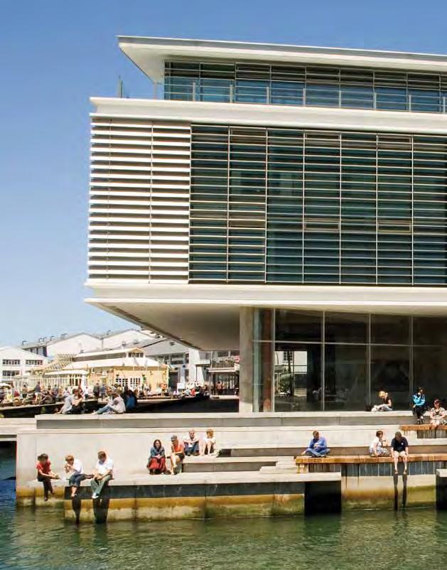
2 INTRODUCTION This design brief provides direction for development in the area known as North Kumutoto, the northern extent of the waterfront s Kumutoto Precinct (referred to in the Wellington Waterfront Framework as North Queens Wharf). The brief aims to fulfil the general objectives outlined in the Waterfront Framework for this area 1. The brief sets out the design principles and parameters for buildings and open spaces. In combination with an indicative layout of spaces and buildings and a maximum building envelope, the brief gives a level of certainty as to the location of open spaces and maximum size and layout of buildings. Although the principles and development parameters provide direction and guidance they also allow some flexibility for parties to be creative in exploring ideas for the development in the area. The principles set out in the brief need to be met in the creation of any site specific guidance and in design development that will occur as part of the development proposal process. 1.1 General design principles The Waterfront Framework sets out the vision and principles for the development of the waterfront and includes the north Kumutoto area. The following vision statement has been adopted for the waterfront: "Wellington's Waterfront is a special place that welcomes all people to live, work and play in the beautiful and inspiring spaces and architecture that connect our city to the sea, and protect our heritage for future generations" (Wellington Waterfront Framework, 2001). Unlike the predominantly open space areas of the Waitangi Park and Taranaki St Wharf precincts, the north Kumutoto area has a strong connection to the City's Central Business District (CBD). This connection will be reflected with a stronger sense of the adjacent city form being developed through a higher proportion of buildings than on the rest of the waterfront. New buildings in this area will have a range of uses and could include recreational, retail, commercial, residential and institutional uses. Generally, the uses need to support a safe waterfront and 24-hour activity. The character of North Kumutoto includes a network of waterfront promenade and lanes connecting back to the CBD. Movements will be designed primarily for pedestrians and cyclists with buildings enclosing the water edge on one side and a major urban boulevard on the other. Any new buildings will relate to and be sympathetic to the scale of the surrounding heritage buildings and items, including Shed 21 at the northern end, Sheds 11 and 13 at the southern end, the Former Eastbourne Ferry Building and the Harbour Board Iron Gates and Railings. Site 8, located to the east of Site 9 and alongside the promenade, is to be excluded from building development and is to be developed as open space. This will help protect views through the Kumutoto area and facilitate public access to the water and pedestrian and recreational use of the area. It will also provide an enlargement of the existing open space (referred to as Kumutoto Plaza) established around the Kumutoto stream opening, facilitate views between the water and Shed 13 and allow for a visual connection between Shed 13 and the Ferry Building. 1.2 District Plan and other statutory plans Any works will need to be undertaken in accordance with the District Plan. Resource Consent applications for new buildings in this area will be notified. In addition, the development of open space on site 8, and in association with building developments on sites 9 and 10, may come under the jurisdiction of Greater Wellington Regional Council and the Regional Coastal Plan. In this case both the WCC and GWRC will work together to coordinate the assessment of resource consent applications. 1.3 Process This brief forms the basis on which Wellington Waterfront Ltd (WWL), Wellington City Council s implementation manager for the waterfront, engages designers or developers for development within the North Kumutoto area. 1 The brief is based on the previous North Queens Wharf design brief (2002) but has been updated to reflect the April 2012 Environment Court decision on District Plan Variation 11 (Wellington Waterfront), development progress in the North Kumutoto area, and public submissions and feedback. 2
3 Designs are considered and approved by Wellington City Council, taking into consideration advice from the Technical Advisory Group (TAG) and feedback from public consultation on preferred development proposals, before being approved. The proposed development is then subject to the resource consenting process which will involve public notification. 1.4 Phasing Building and open space developments may be phased over time taking into account: Economic cycles which influence the timing of commercial development(s). The use of development proceeds to fund the development of public space to minimise the impact on ratepayers. The need to comply with planning requirements and undertake public consultation. 2.0 SITE SPECIFIC ISSUES 2.1 Site boundaries This brief relates to development in the North Kumutoto area the area adjacent to the waterfront between Shed 13, the Meridian Building and Shed 21 and specifically the development of Sites 8 (as open space), 9 and 10 as depicted on Map 2. The North Kumutoto area sits within the wider Kumutoto Precinct which covers the area bounded by Shed 21 in the north through to the Queens Wharf Centre in the south; Waterloo and Customhouse Quays to the west and CentrePort s boundary to the east in the northern sector and the water s edge in the southern sector as shown on Map Links to the city North Kumutoto is an important part of Wellington s waterfront and is the northern most part of the waterfront under the management of WWL. It has a strong relationship to the City's central business district and important links to the north, including Shed 21 and the Railway Station. It also has an important relationship with the ongoing development of CentrePort land (which adjoins the area to the north east) and the Parliamentary precinct to the north west. Improving pedestrian access across the heavily trafficked 'quays' is critical to the success of the development of this part of the waterfront. Wellington City Council has undertaken a quays improvement project and opportunities to link with these improvements should continue to be made (see section 3.0 The Open Spaces ). The greening of the quays project is enhancing the Wellington waterfront route from Aotea Quay through to Oriental Parade. The improvements relating to the Kumutoto Precinct include significant planting of street trees, a central median providing refuge for people crossing between the central business district and the waterfront, an increased number of signalised pedestrian crossings along Jervois and Customhouse Quays (including at Waring Taylor and Johnston streets), and increased shelter from the weather for pedestrians. The main entrance for vehicles on to the waterfront in this area is at Whitmore Street. Access is also possible via the entrance at Bunny Street to the north and Brandon Street in the south. 2.3 Heritage and contemporary culture This area has been long associated with both Maori and European settlement with the Kumutoto Stream exiting in this area. The majority of the North Kumutoto area was reclaimed as late as Opportunities to acknowledge that this reclamation process has happened should be considered in future designs. An example of such historical connection is present in the Kumutoto Plaza where the stream mouth is highlighted through the use of concrete and timber terraces that step down to the water. Another example is at the Taranaki Wharf where the original wharf configuration has been re-exposed. Other aspects of history should also be acknowledged. This should include not only the remaining waterfront buildings, but artefacts such as the wharf gates and wharf structures, and the evidence of past industrial and maritime usage. An example of this has been the restoration of the heritage gates at the Waring Taylor, Johnston and Brandon street entrances to the area. These features are irreplaceable indicators of the history of the area, and while some may be damaged, they substantially enrich the experience of the waterfront. Physical evidence of 3
4 age and occupation are manifestations of the history of the waterfront, and are fundamental in retaining and strengthening the identity of the area. With the change in emphasis of the area from a working port to a recreational, cultural and employment area, there are opportunities for public art to be used to express the history of the area. Public art, interpretation and lighting should be coordinated with the design of new buildings and spaces and reflect the waterfront context and history of the area. There is an opportunity throughout the open spaces to provide interpretation of the wharves associated with the Wellington Harbour Board. 2.4 Pedestrian and cycle access Pedestrians and cycles have priority over vehicles on the waterfront. There are a number of ways of making the waterfront safer, more comfortable, convenient and inviting for people on foot, and there have been significant improvements made in recent years. These include additional pedestrian crossing points across the quays, development of the promenade, new landscaping, lighting, surface treatments, signage and accessibility enhancements. Although opportunities for further enhancements to pedestrian and cycle access and accessibility are limited given the improvements already made, consideration of improvements in key locations, particularly the public spaces surrounding buildings and between buildings and the Whitmore Street extension, should form part of future designs. 2.5 Parking and vehicle access Any parking on the waterfront is to support people who visit, live and work on the waterfront. The number of car parking spaces to be provided depends on the uses of the new buildings. These needs will be covered in resource consent applications. Vehicle access needs to be provided to assist access for the less able and to service the buildings, wharves and parking areas. Pedestrians, cyclists and private, service and emergency vehicles may all share the same internal access space, while still giving pedestrians and cyclists priority over vehicles. 2.6 Views Connections between the North Kumutoto area and its wider context include the views and the glimpses of the harbour and hills beyond and the views along the city streets. The panoramic views from the promenade and water's edge out to the harbour are also important to the character of the North Kumutoto area. Conversely, the views from the harbour and hills back to the city over the area are of importance to the city as a whole. Opportunities also exist to enhance views to Parliament, Sheds 11, 13, 21 and the Former Ferry Terminal Building. Existing views from the city streets towards the harbour and hills should be considered in the design of new buildings and spaces. These views can be framed by buildings to increase the sense of drama and to reinforce the sense of distance and scale. The viewshaft Vs 4 Whitmore Street from the city to the harbour as identified in the District Plan is significant to the area and requires particular attention in open space and building designs. Consideration should also be given to providing views through any new building on sites 9 and 10 to the Ferry Building. 2.7 The Promenade The promenade is continuous, stretching from the Railway Station to Oriental Bay and follows the water's edge for most of the distance. There is a need to keep a consistency of treatment along its length, so that the promenade is clearly defined. The promenade exists in different forms in the different areas of the waterfront. In the North Kumutoto area it forms two paths; a waterside path along the Tug Wharf and Queens Wharf breastwork, and a landside path alongside the reclaimed edge. Opportunities should be taken to provide shelter, seating and activities along the route, including integration with buildings on the landside edge. 4
5 The promenade is a shared pathway, designed to accommodate a range of uses including strolling, cycling, skating, push-scooters, push-chairs and wheel chairs. The promenade not only serves the waterfront but is also part of the wider pedestrian network and a prime cycle route for the city. The promenade at the water's edge is being continuously enhanced to allow people of all abilities to access the water at various points. This is not a natural edge and therefore it contributes to the urban waterfront experience in different ways, for example bridges, sea walls, pontoons, piers. Access and berthage for small craft should be provided along parts of the water's edge. This is important to support the use of the inner harbour for recreational water activities such as boating. 5
6 3.0 THE OPEN SPACES Open spaces of different configurations and locations along the waterfront provide opportunities for the community and visitors to enjoy the harbour setting in different weather conditions and at different times of the day. Open spaces can provide stopping points and space for activities, and enable recreation opportunities and community interactions. Open spaces are also an opportunity to consider the inclusion of historical reference to the north Kumutoto area. Streets and lanes are the primary form of public spaces within the adjacent central city and this space type also appears in the Kumutoto area. Within the Kumutoto area, lanes are used for movement and congregation - linear public spaces designed to be destinations as well as pathways and access routes. Successful streets and lanes are well defined, are unified spaces with their own recognisable character and have activity and vitality at their edges. Three distinct public open spaces have been developed in the Kumutoto Precinct area, the working names of which are Kumutoto Plaza, Wharf Plaza and Brandon Plaza. The plazas are connected by a lane (Kumutoto Lane) that runs through the precinct. These public spaces link city to sea, extending the line of city streets across Customhouse Quay through to the waterfront. These spaces are summarised as follows: Location Description Importance Kumutoto Plaza (Waring Taylor City connector space Part of the visual link between the city and harbour. St extension) Wharf Plaza (Johnston St City connector space Part of the visual link between the city and harbour. extension) Brandon Plaza (between Steamship Wharf and the Queens Wharf centre) Link space Enhances the relationship between buildings, links to the harbour, servicing space, and access to the Queens Wharf underground car park. Kumutoto Lane (service lane alongside harbour side of Sheds 11 and 13) Linear movement space Shared surface where pedestrian access is shared with primary servicing space for North Kumutoto. Key public open spaces proposed for development or subject to ongoing/further development are summarised in the following table. Location Description Issues The promenade Linear movement space Primarily water edge based movement space. To relate to promenade along rest of waterfront. Connection from the Meridian building through to Shed 21 and the Railway Station to be improved. Provision for NZ Police operations from the wharf. Whitmore St extension City connector space Major entry point to waterfront. Conflict between vehicles and pedestrians needs to be resolved, and the space needs to better defined. Detailed design should occur along with the Site 10 design. Buildings on sites 9 and 10 should provide a gateway and define the open space. This is subject to protection of District Plan viewshaft (VS 4 - Whitmore Street). Site 8 - water edge, north of Kumutoto Stream Activity and destination space Generation of and support for activity and public occupation, connections to the water, spatial definition, integration with spaces and routes around, positive relationship with Kumutoto Plaza open space and Site 9. Site 8 should be designed together with Site 9 as an integrated whole. 6
7 3.1 Open space principles The open spaces in this area (including Site 8) are to be interlinked and are to be designed in a coherent fashion that relates to the waterfront and the wider city context. Public spaces should be easily accessed by all and support uses that can contribute to the vitality, safety, recreational potential, shelter, comfort and social inclusiveness of the waterfront. Diversity of use will support diversity of opportunity, of occupation, and extended use of the waterfront. Successful public spaces are characterised by spatial definition, sunshine, areas of shelter, activity around the edges, views in and out and connection with other space. They usually contain a feature or focal point that gives them a distinctive character. The potential for concealment and entrapment needs to be minimised. Public open spaces should be designed to maximise personal safety in line with the Council s Guidelines for Design Against Crime and best practice in Crime Prevention Through Environmental Design (CPTED). Public spaces that are flexible in design allow for multiple and changing activities. Often these activities are unforeseen. Possible activities include all those typically seen in city streets and open spaces and might also include performance art, children's play, vending, public meetings, fishing, picnicking, rollerblading and any other waterfront recreational event. Public spaces that are responsive to changes in use are desirable to ensure continued activity and vitality on the waterfront. Public spaces should incorporate opportunities for planting trees and integrating coastal ecologies. Well designed open spaces provide an opportunity to enhance the setting of heritage buildings and items. The design of open spaces should consider opportunities for interpretation and public art to highlight the historical context of the area. 3.2 Site 8 considerations Site 8 is an important site in the North Kumutoto area. It is to be developed as public open space. The space needs to be a recognised destination with a positive relationship to the Kumutoto Plaza open space. Like the spaces created by extruding Whitmore, Waring Taylor and Johnston streets on to the waterfront, the space needs careful consideration in order to support diversity, richness and activity. The space could include defining elements which can be recognised from a distance and may include structures that provide shelter from the weather, support activity in the area and promote the use of the space (e.g. playground equipment, performance art, coffee vending) throughout the year, throughout the week and throughout the day. Solar analysis of any proposed building on Site 9 will be required to ensure adequate sunshine for good quality public amenity in this space. There is specific opportunity within and adjacent to Site 8 to recognise the history of the area and enhance the setting of heritage buildings (see section 2.3). 3.3 Furniture guidelines The Waterfront Furniture Design Brief will need to be consulted at the developed design stage. Advice from the Council s Accessibility Advisory Group should also be sought. The brief states that the furniture on the waterfront needs to reflect the industrial and nautical elements of a working wharf. It recommends the use of metal and timber as preferred materials and the elements used to connect them such as bolts, chains and plates. These are expressed on the waterfront in four main forms: planks (ship/wharf decking) balls (buoys, bollards ) plates (cranes, ship hulls) 7
8 masts (cranes, ship masts). All elements are strong, bold and robust. Salvaged timber and materials are used where available, to maximise their effect and as appropriate to their purpose. 8
9 4.0 NEW BUILDINGS The development of the Kumutoto Precinct has seen buildings developed on Site 7 (the Meridian building) and Site 6 (Steamship Wharf). There are two remaining sites defined as being appropriate for new building developments. The maximum building heights and maximum site coverage are outlined below. The heights relate to the scale of adjacent heritage buildings. Further small scale structures might provide services and amenities for public open space areas. These would be integral parts of the design of the space, be used to support everyday occupation and events within the space and also to provide for New Zealand Police operations on the former Ferry Terminal Wharf. Location Site 10 - north of Whitmore St gates, south of Shed 21 Site 9 - to south of Whitmore St gates alongside Customhouse Quay Maximum site coverage Maximum height above ground level Issue 100%2 22 metres3 Strong relationship with Shed 21.Southern end could form part of gateway at end of Whitmore St. The building form should read as more than one building. The eastern edge should align with the eastern façade of Shed 21 and should allow a setback greater than 9m to allow for pedestrian and vehicle movement on the seaward side. Building design should relate positively to the Former Ferry Terminal Building and contribute to the amenity of the Whitmore St extension space, providing an interface area at the southern end. 100% 19m and 16m at south end Northern end could form part of gateway at the end of Whitmore St. Floor to floor heights of new buildings should relate to the generous storey heights of the surrounding buildings. As outlined, Site 8 (to the east of Site 9 and alongside the promenade) is to be excluded from building development (except for small structures ancillary to the open space function) and is to be developed as open space. 4.1 New building principles New buildings will be sympathetic to, and relate to the scale and size of, the heritage buildings, bearing in mind that Shed 21 at the northern end is higher than the heritage buildings at the southern end. Any building on site 10 must relate to the Former Ferry Terminal Building and reflect its degree of importance as a heritage item. Primary facades are to face on to the major public open spaces. Secondary facades are to provide for a level of servicing, but not be dominated by these servicing activities. All facades are to provide a high level of active edge. Consideration should be given to activating the upper levels of buildings, potentially with balconies and terraces as well as visual connections. Buildings will be designed in a coherent fashion that relates to the area s urban context including the waterfront, nearby buildings including heritage buildings, and the CBD landward of north Kumutoto, and have a good compositional relationship with neighbours so that they relate to and complement each other. 2 The building footprint is to relate to the Ferry Building and Whitmore St extension space. 3 No roof top structures can penetrate the maximum height. 9
10 Building types that would be responsive to change of uses over time are preferred. The buildings, including tops and roofs, need to provide the character and complexity appropriate to their prominent waterfront position and context, given that there are numerous vantage points overlooking this area. Opportunities for green roofs and public access to roof tops should also be incorporated where appropriate. Buildings need to have visual interest with recognition of different viewing distances and duration. Buildings will be required to display exceptional architectural design including innovation, creativity and imagination, responsiveness to context, environmentally sustainable design and be an expression of contemporary culture. Buildings will be designed with consideration of universal design principles to ensure accessibility for all. 4.2 Building relationship to open space Buildings should contribute positively to the open spaces of the waterfront. Buildings should be of a size and shape that relate to the spaces around them, the neighbouring buildings and the water s edge. Buildings can provide enclosure and shelter to adjacent spaces. Buildings are to provide a protected sheltered accessible route along the quays and are to contribute to providing shelter along the promenade. Buildings may become landmarks and add character to public spaces. The buildings that face onto the public spaces should help define these spaces, provide for natural surveillance and allow for activities that engage people using these spaces. The ground floors of buildings should be predominantly and clearly accessible to the public, adding to the overall vitality and activity of the waterfront. This can include commercial activity provided it is aimed at the general public. Buildings should have 'active edges' by providing frequent entries. Windows and doors at ground level should allow visual links between ground level interiors and adjacent public spaces and allow people to interact with activities within the building. Servicing facilities need to be integrated into the building and/ or located along secondary frontages. Buildings above ground floor level should relate to surrounding open spaces, potentially and where appropriate integrating balconies and/or roof-decks in order to establish a sense of connection with and add to the vitality and safety of these open spaces. 10

11 Map 1 North Kumutoto location and context 11
")
12 Map 2 North Kumutoto: Sites 8, 9 and 10 location and development areas map (Indicative only: not to scale) 12
North Kumutoto Landscape Design Statement. Resource Consent. for Wellington City Council. Purpose of Issue:
 North Kumutoto Landscape Design Statement for Wellington City Council IGL 3158 DS001 (Revision A) Date:03.11.2014 Purpose of Issue: Resource Consent 1.0 Introduction 1.1 Wellington City Council intends
Building and Public Space Design Guidelines
 AMERICA'S CUP WYNYARD HOBSON Building and Public Space Design Guidelines INTRODUCTION 10 April 2018 The 36 th America s Cup in Auckland requires the construction of new wharf and breakwater structures.
East Bayshore Road Neighbourhood
 East Bayshore Road Neighbourhood Northridge Property Management Urban Design Brief 3195 East Bayshore Road City of Owen Sound January 2016 East Bayshore Road Neighbourhood Northridge Property Management
2.0 Urban Design Concepts
 0 Urban Design Concepts Urban Design Concept diagrams The Waterfront Axis The Park Axis The Wharf Axis Waterfront Precincts 0.1 The Four Key Concepts: This Concept for the Wynyard Quarter establishes four
97 Lea Bridge Road, Leyton, E10 7QL London Borough of Waltham Forest December 2015
 97 Lea Bridge Road, Leyton, E10 7QL London Borough of Waltham Forest December 2015 Public Realm and Landscape Proposals LEA BRIDGE ROAD, WALTHAMSTOW Public Realm & Landscape Proposals BDP(90)RPT001 December
WELLINGTON HOSPITAL DESIGN GUIDE TABLE OF CONTENTS
 WELLINGTON HOSPITAL DESIGN GUIDE TABLE OF CONTENTS 1.0 Introduction Page 2 The Place of Wellington Hospital 2 The Future of the Hospital 2 2.0 The Intention of the Design Guide 3 3.0 Analysis 4 General
PART AOTEA PRECINCT
 CONTENTS... PAGE AOTEA PRECINCT...4 14.5.1 INTRODUCTION...4 14.5.2 RESOURCE MANAGEMENT ISSUES...4 14.5.3 RESOURCE MANAGEMENT OBJECTIVES AND POLICIES... 4 14.5.4 RESOURCE MANAGEMENT STRATEGY...5 14.5.5
2.0 Strategic Context 4
 2.0 Strategic Context 4 2.1 The Area Action Plan is a non-statutory plan, which forms a corporate policy document, expressing particular issues and areas of concern while also providing a vision for the
Place Brief. National Collections Facility (NCF site)
") Place Brief. National Collections Facility (NCF site) Contents 1.0 Purpose 2.0 Location and Proposal 3.0 Vision and Aim 4.0 Placemaking Principles 5.0 Conclusion Plan 1 Location Plan Plan 2 Placemaking
Place Brief. National Collections Facility (NCF site) Contents 1.0 Purpose 2.0 Location and Proposal 3.0 Vision and Aim 4.0 Placemaking Principles 5.0 Conclusion Plan 1 Location Plan Plan 2 Placemaking
The Proposed Auckland Unitary Plan (notified 30 September 2013)
") 3 Business zones Introduction There are 10 business zones in the Unitary Plan: City Centre Metropolitan Centre Town Centre Local Centre Neighbourhood Centre Mixed Use General Business Business Park Light
3 Business zones Introduction There are 10 business zones in the Unitary Plan: City Centre Metropolitan Centre Town Centre Local Centre Neighbourhood Centre Mixed Use General Business Business Park Light
AOTEA SUPERMARKET ZONE. Zone Introduction
 C18 AOTEA SUPERMARKET ZONE Zone Introduction C18.1 Objective This zone identifies a specific area in Aotea for a stand alone supermarket. The zone is site specific and has a range of objectives, policies
Subdivision Design Criteria. Penihana North GUIDELINES TO THE RULES
 Created September 2013 Penihana North Subdivision Design Criteria GUIDELINES TO THE RULES This part of the Plan sets out the design criteria for subdivision in Penihana North. The criteria will be considered
Chapter 2: OUTLINE PLANNING APPLICATION PROPOSALS. A New Garden Neighbourhood Matford Barton 17
 Chapter 2: OUTLINE PLANNING APPLICATION PROPOSALS A New Garden Neighbourhood Matford Barton 17 2.1. SUMMARY AND STATUS OF THE PROPOSALS 2.1.1. The parameter plans and associated wording in this chapter
Memorial Business Park Site. Proposed Future Development. Design guidelines. August
 Memorial Business Park Site Proposed Future Development Design guidelines August 2014 www.designenvironment.co.nz 0064 3 358 3040 Contents 1.0 Background 1.1 Introduction 3 1.2 Objectives 4 2.0 Context
I615. Westgate Precinct
 I615. Westgate Precinct I615.1. Precinct Description The Westgate Precinct is located approximately 18km west of the Auckland city centre. There are seven Sub-precincts in the Westgate Precinct: Sub-precinct
Chapter 5 Urban Design and Public Realm
 5.1 Introduction Public realm is all areas of the urban fabric to which the public have access. It is where physical interaction takes place between people. It therefore, includes buildings and their design,
3.5 Principle 5/Response
 5 Principle 5/Response Existing street network Proposed street network Pedestrian street hierarchy Existing streets Existing Regional Arterial 4 Existing Street Network Existing and proposed streets Indicative
Welcome. Community Consultation Meeting November 28, Review and discuss the Bathurst Quay Neighbourhood Plan Framework
 Welcome Community Consultation Meeting November 28, 2016 Why Are We Here Today? Review and discuss the Bathurst Quay Neighbourhood Plan Framework Review and discuss an Action Plan for Implementation Next
Creating an integrated waterfront. Recommendations
 Creating an integrated waterfront Recommendations Railway Square Post Office + Shell Station Post Office Square Civic Square Ilot Green Wakefield St Wakefield St (Tory Cars) Wakefield St (New World Supermarket)
Section Three, Appendix 16C Medium Density Housing, Design Assessment Criteria (Residential 8A zone)
") APPENDIX 16C MEDIUM DENSITY HOUSING, DESIGN ASSESSMENT CRITERIA (RESIDENTIAL 8A ZONE) PURPOSE OF APPENDIX 16C (RESIDENTIAL 8A ZONE) In the Residential 8A Zone the following are defined as restricted discretionary
APPENDIX 16C MEDIUM DENSITY HOUSING, DESIGN ASSESSMENT CRITERIA (RESIDENTIAL 8A ZONE) PURPOSE OF APPENDIX 16C (RESIDENTIAL 8A ZONE) In the Residential 8A Zone the following are defined as restricted discretionary
M i s s i o n B a y W a t e r f r o n t
 114 M i s s i o n B a y W a t e r f r o n t Character of the Area: The Mission Bay Waterfront extends from Pier 48 at China Basin Channel to 18th Street in the Central Basin. This area of the waterfront
SECTION ONE North East Industrial Zone Design Guide Palmerston North City Council June 2004
 SECTION ONE North East Industrial Zone Design Guide Palmerston North City Council June 2004 young heart easy living 1 Preface Industrial areas are a very important component of the economic well-being
Wide asphalt driveway abutting school property. garage built with incompatible materials, too close to park. incompatible fencing materials
 Wide asphalt driveway abutting school property incompatible fencing materials garage built with incompatible materials, too close to park Lack of plantings as a buffer between private property and open
Colchester Northern Gateway Master Plan Vision Review Draft. July 2016
 Colchester Northern Gateway Master Plan Vision Review Draft July 2016 Contents Introduction 4 Context 8 Purpose of the Report 8 Strategic Position 9 Overview of the Process 11 2012 Master Plan Vision 12
Central Area Urban Design Guide Appendix 1 - Pipitea Precinct (Pi)
") Central Area Urban Design Guide Appendix 1 - Pipitea Precinct (Pi) Applies Also to the Port Redevelopment Precinct ( Pipitea refers to the clear waters over the pipi beds) Contents Introduction - Definition
Central Area Urban Design Guide Appendix 1 - Pipitea Precinct (Pi) Applies Also to the Port Redevelopment Precinct ( Pipitea refers to the clear waters over the pipi beds) Contents Introduction - Definition
PUBLIC RIGHT-OF-WAY IN THIS CHAPTER PUBLIC REALM
 PUBLIC RIGHT-OF-WAY This section provides design guidelines for improvements in the public right-of-way. The public right-of-way refers to streets, sidewalks, non-vehicular thoroughfares, parks and greenways
Section Three, Appendix 17C Multiple Unit Housing Design Assessment Criteria
 APPENDIX 17C MULTIPLE UNIT HOUSING DESIGN ASSESSMENT CRITERIA Purpose of Appendix 17C In the Residential 9 Zone the construction and use of multiple household units located within the Multiple Household
APPENDIX MATAKANA COMMERCIAL URBAN DESIGN GUIDELINES
 APPENDIX MATAKANA COMMERCIAL URBAN DESIGN GUIDELINES 1.0 INTRODUCTION The following urban design guidelines are to be utilised by landowners, planners and other persons involved in development at early
6 Site Framework Strategies
 6 Site Framework Strategies 6.1 Introduction Section 6 identifies a number of specific areas which are considered to be key sites within the Plan area and which may have potential for development / redevelopment.
PART 3 - RESOURCE MANAGEMENT
 CONTENTS... PAGE 3.1 INTRODUCTION... 3 3.2 NATURAL AND PHYSICAL ENVIRONMENT... 3 3.3 URBAN SUSTAINABLE MANAGEMENT... 5 3.4 RESOURCE MANAGEMENT ISSUES... 5 3.5 RESOURCE MANAGEMENT OBJECTIVES AND POLICIES...
WINDSOR GLEN DESIGN GUIDELINES
 WINDSOR GLEN DESIGN GUIDELINES Adopted by Council, 2006 WINDSOR GLEN REDEVELOPMENT DESIGN GUIDELINES August 2006 1.0 Master Plan Organization For this area of the Coquitlam Town Centre, a mix of high,
Tauranga City Centre Spatial Framework
 Tauranga City Centre Spatial Framework Stakeholder Engagement Workshop 15 October 2015 Project Design Team Beca & LandLAB Our team Henry Crothers (LandLab) Landscape Architect/Urban Designer Urban and
3.1 Existing Land Use
 3.0 Land Use This strategy has been developed taking into account the position of the Town of Sidney as the economic center of the Saanich Peninsula. It acknowledges existing land use patterns in the downtown
8.0 Design and Form of Development 43/
 42/ 8.0 Design and Form of Development 43/ Rothwells Farm, Golborne/ Development Statement Figure 7. Site Constraints Key 44/ Site Boundary 360 Bus Route/Stops Existing Trees Underground Water Pipe Sensitive
Market Place Bythell Place Queen Street Park Riverside Park. Public Spaces. Blenheim CBD Streetscape Final Report 36
 37 39 41 43 Market Place Bythell Place Queen Street Park Riverside Park Final Report 36 Market Place Market Place is a key space for Blenheim s street life, it is a meeting place, retail edge and pedestrian
Proposals for the regeneration of Standard Quay, Faversham, Kent
 Proposals for the regeneration of Standard Quay, Faversham, Kent The purpose of this information is to explain the progress in regenerating Standard Quay and to outline proposals with indicative timescales
A PLANNING DIALOGUE CHAPTER VICTORIA QUAY COMPOSITION AND IDENTITY FEMANTLE CITY OF THREE WATERFRONTS PATHWAYS OVER THE RAIL NEW PERMEABILITY
 1 FEMANTLE CITY OF THREE WATERFRONTS 2 PATHWAYS OVER THE RAIL NEW PERMEABILITY 3 VIEW CORRIDORS VISUAL PRESENCE OF THE PORT 4 THE JOURNEY WITHIN VICTORIA QUAY 6 AN AUTHENTIC PORT... AN AUTHENTIC PLACE
PUBLIC REALM STUDY AREA
 WELCOME PUBLIC REALM STUDY AREA WHAT IS PUBLIC REALM? Welcome to the Ballina Town Public Realm public consultation event. Mayo Council is in the process of producing a Public Realm Strategy for Ballina
7.2.9 Eudlo local plan code
 7.2.9 local plan code 7.2.9.1 Application (1) This code applies to assessable development:- (a) within the local plan area as shown on Map ZM29 contained within Schedule 2 (Mapping); and (b) identified
Housing Development at Balloonagh Tralee Co Kerry
 Design Statement Housing Development at Balloonagh Tralee Co Kerry Area of site 10,400m2 24 houses-12no 3 bed, 12no 2 bed and 4 single bed apartments total residential area of 2411m2 Open space provided
Section 4 - Public Realm & Landscape proposals Landscape Masterplan. Section 4 52
 - Public Realm & Landscape proposals Landscape Masterplan 52 Proposed Masterplan - Green Infrastructure Strategy District Park 4.33 Ha to provide Passive and active recreation with a large play area which
Central Area Urban Design Guide
 Last Amended 12 September 2012 Central Area Design Guide Operative 27/07/00 Central Area Urban Design Guide Contents Introduction - Intention - Using this Guide Wellington Context 1 Design Coherence -
RIVERSIDE DESIGN CD-1 GUIDELINES. Adopted by City Council August 9, 1983
 $1 City of Vancouver Land Use and Development Policies and Guidelines Community Services, 453 W. 12th Ave Vancouver, BC V5Y 1V4 F 604.873.7344 fax 873.7060 planning@city.vancouver.bc.ca RIVERSIDE DESIGN
I609. Penihana North Precinct
 I609. Penihana North Precinct I609.1. Precinct description The Penihana North Precinct is located south of the Swanson Railway Station, adjacent to the Rural Urban Boundary (RUB) and Waitakere Ranges Heritage
Nelson Residential Street Frontage Guideline
 DRAFT 22-06-2012 Nelson Residential Street Frontage Guideline June 2012 1317273 Contents and purpose Residential s are important Residential s are much more than corridors which move traffic. Streets allow
SCHEDULE 12 TO THE DESIGN AND DEVELOPMENT OVERLAY GLEN WAVERLEY ACTIVITY CENTRE STRUCTURE PLAN
 DD/MM/YY Proposed C120 SCHEDULE 12 TO THE DESIGN AND DEVELOPMENT OVERLAY Shown on the planning scheme map as DDO12. GLEN WAVERLEY ACTIVITY CENTRE STRUCTURE PLAN 1.0 Design objectives DD/MM/YY Proposed
INCREMENTAL CHANGE AREA REVIEW March 2015 Page 1
 INCREMENTAL CHANGE AREA REVIEW March 2015 Page 1 Table of Contents Introduction... 3 Background to Review... 3 Comparison of the Schedules to the General Residential Zone... 7 Methodology... 7 Policy Context...
Waikato Innovation Park Masterplan. 13 NOVEMBER 2015 Prepared for Waikato Innovation Park Limited // Prepared by Beca
 Waikato Innovation Park Masterplan 13 NOVEMBER 2015 Prepared for Waikato Innovation Park Limited // Prepared by Beca Figure 1: Waikato Innovation Park Strategic Context 1 INTRODUCTION 1.1 Waikato Innovation
Part 10 Town Centre Area Plans Toronto
 CONTENTS: 1 INTRODUCTION... 3 1.1 BACKGROUND... 3 1.2 EXISTING CHARACTER... 4 1.3 ENVIRONMENTAL CONSTRAINTS... 6 1.4 DESIRED FUTURE CHARACTER... 6 2 DEVELOPMENT CONTROLS... 8 2.1 BLOCK CONTROLS... 9 3
Clairtrell Area Context Plan
 Clairtrell Area Context Plan March 2005 Urban Development Services City Planning Contents 1. Introduction... 4 2. Development Structure... 6 2.1 Streets... 7 2.1.1 Sheppard Avenue and Bayview Avenue...
THREE PARKS ZONE Three Parks Special Zone The process of applying for resource consents in the zone.
 .25 Three Parks Special Zone The purpose of this zone is to provide for growth and to give effect to the Wanaka 2020 Community (2002) and the more recent Wanaka Structure (2007) and Wanaka Transport Strategy
Table 8-4: Road Classification Local Roads, second table, of Chapter 8 Create a Multi-Modal City, be amended by adding the following:
 1 Port Street East Official Plan Amendment APPENDIX 3 Amendments to Mississauga Official Plan Table 8-4: Road Classification Local Roads, second table, of Chapter 8 Create a Multi-Modal City, be amended
Public Space. Design Policy
 Public Space Design Policy December 00 Contents Purpose of this policy Introduction... Purpose of this policy... Objectives and policies... Objective... To enhance Wellington s sense of place This Public
Figure 3-1: Public Realm Plan
 3 Public Realm Figure 3-1: Public Realm Plan 3.1 Public Realm Concept The public realm concept for the Little Mountain site integrates a clear and accessible movement network with public spaces for social
Keystone Business Park Precinct Structure Plan North East Industrial Precinct. Part 2 Design Principles
 Keystone Business Park Precinct Structure Plan North East Industrial Precinct Part 2 Design Principles Context Issues Services Landform Issues Geotech and contamination Ecology Traffic and access Issues
STATEMENT OF OBJECTION TO THE PROPOSED DEVELOPMENT OF LAND AT CHURCH CLIFF DRIVE FILEY
 STATEMENT OF OBJECTION TO THE PROPOSED DEVELOPMENT OF LAND AT CHURCH CLIFF DRIVE FILEY You will be aware that Scarborough borough council have adopted a new local plan that includes land at Church Cliff
22.15 OUTDOOR ADVERTISING SIGNAGE POLICY
 22.15 OUTDOOR ADVERTISING SIGNAGE POLICY This policy applies to all land where a planning permit is required to construct or display a sign under the provisions of the Kingston Planning Scheme. 22.15-1
design & access statement Proposed Erection of 68 Bedroom Hotel and Restaurant with Associated Landscaping
 Proposed Erection of 68 Bedroom Hotel and Restaurant with Associated Landscaping Promenade, design & access statement lawrencemcphersonassociates 6 new road, ayr, ka8 8ex On Behalf of July 2015 CONTENTS
Response to the London Bridge Area Vision and Site Allocations within the New Southwark Plan
 1 Melior Place London SE1 3SZ 020 7407 4701 teamlondonbridge.co.uk info@teamlondonbridge.co.uk 28 April 2017 Response to the London Bridge Area Vision and Site Allocations within the New Southwark Plan
PDA SUBMISSION: Queen s Wharf, Brisbane (DEV2017/846)
") PDA SUBMISSION: Queen s Wharf, Brisbane (DEV2017/846) Date:: 17 October 2017 Contact Officer: Jonathon Fisher Chief Executive Officer Email: heritage@nationaltrustqld.org Phone: 07 3223 6666 NATIONAL TRUST
PDA SUBMISSION: Queen s Wharf, Brisbane (DEV2017/846) Date:: 17 October 2017 Contact Officer: Jonathon Fisher Chief Executive Officer Email: heritage@nationaltrustqld.org Phone: 07 3223 6666 NATIONAL TRUST
Site Planning. 1.0 Site Context. 2.0 Pedestrian Circulation Systems. Pag e 2-23
 The following photographs from throughout the country illustrate key urban design principles. Photographs are provided to illustrate the overall urban design concepts described in Chapter 1 of the Downtown
The Wellington Waterfront Framework. Report of the Waterfront Leadership Group April 2001
 The Wellington Waterfront Framework Report of the Waterfront Leadership Group April 2001 ISBN 0-909036-75-6 Published by Wellington City Council 101 Wakefield Street Wellington New Zealand Telephone 64-4
Derry Green Corporate Business Park
 Town of Milton Derry Green Corporate Business Park Urban Design Guidelines BMI/Pace - June 2010 Draft 3 Prepared by: Brook McIlroy Planning + Urban Design / Pace Architects Suite 300-51 Camden Street Toronto,
Urban Design Manual PLANNING AROUND RAPID TRANSIT STATIONS (PARTS) Introduction. Station Study Areas
 Introduction. Station Study Areas") 111111 PLANNING AROUND RAPID TRANSIT STATIONS (PARTS) Introduction The ION rapid transit system will link Waterloo, Kitchener and Cambridge through a central transit corridor (CTC). There are a number
111111 PLANNING AROUND RAPID TRANSIT STATIONS (PARTS) Introduction The ION rapid transit system will link Waterloo, Kitchener and Cambridge through a central transit corridor (CTC). There are a number
I209 Quay Park Precinct
 I209. Quay Park I209.1. Precinct description The Quay Park Precinct is located on reclaimed land at the eastern end of the city centre and along the City Centre waterfront. It is dissected to the east
edge of gas line corridor setback edge of gas line corridor aligned with Schlumberger building 37.0 m AOD 33.0 m AOD max
 7. Heights and Street Frontage: In accordance with the approved heights parameters, heights to along Western Access Road must respond to the existing low density character in this location. Heights are
ROCHFORD LOCAL DEVELOPMENT FRAMEWORK: Sustainability Appraisal/ Strategic Environmental Assessment. Rochford Core Strategy Preferred Options Document
 ROCHFORD LOCAL DEVELOPMENT FRAMEWORK: Sustainability Appraisal/ Strategic Environmental Assessment Non Technical Summary Rochford Core Strategy Preferred Options Document October 2008 SUSTAINABILITY APPRAISAL
Tāhuhu whakaruruhau ā-taone The sheltering ridge pole
 B2. Tāhuhu whakaruruhau ā-taone - Urban growth and form B2.1. Issues Tāhuhu whakaruruhau ā-taone The sheltering ridge pole Auckland s growing population increases demand for housing, employment, business,
Cotswolds AONB Landscape Strategy and Guidelines. June 2016
 Cotswolds AONB Landscape Strategy and Guidelines June 2016 Cotswolds AONB Landscape Strategy and Guidelines Introduction The evolution of the landscape of the Cotswolds AONB is a result of the interaction
Port Lavaca Future Land Use
 Port Lavaca Future Land Use Introduction The City of Port Lavaca is beginning to see sustained growth, after many years of relative stable population. New single family homes, apartments, and businesses
10 Proposed Redevelopment, Tewkesbury Road, Cheltenham SCHEME EVOLUTION STARBUCKS
 SCHEME EVOLUTION STARBUCKS The proposed Starbucks Drive Thru alongside the proposed food store provides an appropriate mix of uses, suitable for this location. The proposed store is bespoke, designed specifically
PART 6 - HUMAN ENVIRONMENT
 CONTENTS...PAGE 6.1 INTRODUCTION...3 6.2 ISSUES AND STRATEGY...3 ISTHMUS SECTION - OPERATIVE 1999 Page 1 Page 2 ISTHMUS SECTION - OPERATIVE 1999 PART 6 - HUMAN ENVIRONMENT 6.1 INTRODUCTION The Plan seeks
Newcourt Masterplan. November Exeter Local Development Framework
 Newcourt Masterplan November 2010 Exeter Local Development Framework Background The Exeter Core Strategy Proposed Submission sets out the vision, objectives and strategy for the development of Exeter up
Cape Cabarita (Formerly known as the Wellcome Site) Development Control Plan. Date of Adoption: 4 September 2007 Effective Date: 7 March 2008
 Development Control Plan. Date of Adoption: 4 September 2007 Effective Date: 7 March 2008") Cape Cabarita (Formerly known as the Wellcome Site) Development Control Plan Date of Adoption: 4 September 2007 Effective Date: 7 March 2008 Development Control Plan Index 1 INTRODUCTION...3 1.1 LAND TO
Cape Cabarita (Formerly known as the Wellcome Site) Development Control Plan Date of Adoption: 4 September 2007 Effective Date: 7 March 2008 Development Control Plan Index 1 INTRODUCTION...3 1.1 LAND TO
New-Cast Mixed-use Development Proposal King Street West, Newcastle, Ontario
 URBAN DESIGN BRIEF New-Cast Mixed-use Development Proposal King Street West, Newcastle, Ontario TABLE OF CONTENTS: 1.0 Executive Summary 2.0 Creating Vibrant and Sustainable Urban Places: Excerpts from
RESIDENTIAL ACTIVITY PERFORMANCE STANDARDS
 Preferred Options Consultation Q&A Sheet RESIDENTIAL ACTIVITY PERFORMANCE STANDARDS What are the key goals for managing the design of residential buildings in the Second Generation Plan (2GP)? The key
The Master Plan Framework
 The Master Plan Framework The East Harbour Master Plan advances the development of 60 acres of former industrial lands east of the Don River. The Master Plan outlines a vision for a vibrant, transit-oriented
medium desnity housing
 This section updated September 2013 This part of the Plan sets out the assessment criteria for medium density housing. The criteria are designed to give designers and builders flexibility and to provide
3.0 Area-Wide Strategies 30
 3.0 Area-Wide Strategies 30 3.6 Tourism Strategy This section of the plan aims to develop and improve the tourism potential of the area. Strategic Context The City Plan outlines the potential of Cork to
Description Details submitted pursuant to discharge of condition 5 (Design Code) attached to planning permission 13/01729/OUT.
 attached to planning permission 13/01729/OUT.") ITEM 9 Application Number: 18/00266/DISCON Description Details submitted pursuant to discharge of condition 5 (Design Code) attached to planning permission 13/01729/OUT. AT The Point, 602 Midsummer Boulevard,
ITEM 9 Application Number: 18/00266/DISCON Description Details submitted pursuant to discharge of condition 5 (Design Code) attached to planning permission 13/01729/OUT. AT The Point, 602 Midsummer Boulevard,
Chapter 13 Residential Areas: Appendices APPENDIX 1 Residential Areas
 Chapter 13 Residential Areas: Appendices Page 1 Chapter 13 Residential Areas: Appendices APPENDIX 1 Residential Areas Design Code for Intensive Housing INTRODUCTION DESIGN ELEMENTS A NEIGHBOURHOOD DESIGN
AIRPORT BUSINESS PARK
 PIER MAC PETROLEUM INSTALLATION LTD. AIRPORT BUSINESS PARK DEVELOPMENT APPLICATIONS March 2003 4.1 Airport Business Park Development Permit Area 4.1.1 Justification/Design Concept The design concept envisioned
BLETCHLEY PARK AREA - DEVELOPMENT FRAMEWORK
 ANNEX A To Item 9 REVISED TEXT: additions shown bold and underlined, deletions in (brackets and in italics). BLETCHLEY PARK AREA - DEVELOPMENT FRAMEWORK This framework sets out the key objectives and requirements
WELLINGTON STREET WEST COMMUNITY DESIGN PLAN
 36 3.CDP POLICIES 37 Wellington Street West CDP Vision Statement 38 3.1 Introduction 3.1.1 Purpose The development of buildings and public spaces is influenced by a variety of factors over time. City of
REMARKABLES PARK ZONE
 .10 Remarkables Park Zone.10.1 Resources, Activities and Values The Remarkables Park Area comprises approximately 150 hectares of perimeter urban land in the vicinity of Frankton and occupies a strategic
H7 Open Space zones. (a) provide for the needs of the wider community as well as the needs of the community in which they are located;
 provide for the needs of the wider community as well as the needs of the community in which they are located;") H7. Open Space zones H7.1. Background The majority of land zoned as open space is vested in the Council or is owned by the Crown. However some areas zoned open space are privately owned. While the open
H7. Open Space zones H7.1. Background The majority of land zoned as open space is vested in the Council or is owned by the Crown. However some areas zoned open space are privately owned. While the open
Chairman and Members of the Planning and Development Committee. Thomas S. Mokrzycki, Commissioner of Planning and Building
 LA.09.TOR (Toronto) DATE: TO: FROM: SUBJECT: Chairman and Members of the Planning and Development Committee Thomas S. Mokrzycki, Commissioner of Planning and Building Central Waterfront Secondary Plan
HS2 Interchange Station Design
 Working on behalf of HS2 Interchange Station Design October 2018 www.hs2.org.uk 1 Interchange Station, Solihull Introduction In February 2018, HS2 Ltd appointed Arup to take forward the design of Interchange
I404 Beachlands 2 Precinct
 I404. Beachlands 2 I404.1. Precinct Description The Beachlands 2 precinct covers approximately 6 hectares of land at the corner of Beachlands and Whitford Maraetai Roads. Its purpose is to provide for
URBAN DESIGN BRIEF URBAN DESIGN BRIEF 721 FRANKLIN BLVD, CAMBRIDGE August 2018
 URBAN DESIGN BRIEF URBAN DESIGN BRIEF 721 FRANKLIN BLVD, CAMBRIDGE August 2018 DESIGN BRIEF CONTENTS PART A 1.0 INTRODUCTION 2.0 DESCRIPTION & ANALYSIS OF SITE CONTEXT 3.0 DESIGN CONSTRAINTS AND OPPORTUNITIES
Task Force on Kai Tak Harbourfront Development
 Task Force on Kai Tak Harbourfront Development For discussion on 29 March 2018 TFKT/04/2018 Study of Kai Tak Promenade Design Control and Guidelines Conceptual design scheme for Promenade at Runway Precinct
Welcome. Walk Around. Talk to Us. Write Down Your Comments
 Welcome This is an information meeting introducing the applications for proposed redevelopment of the Yorkdale Shopping Centre site at 3401 Dufferin Street and 1 Yorkdale Road over the next 20+ years,
Page 1 of 19 URBAN DESIGN FRAMEWORK FOR BOLTON STREET WATERFORD
 Page 1 of 19 URBAN DESIGN FRAMEWORK FOR BOLTON STREET WATERFORD 1.0 Introduction: The relocation of the City Council stores and depot from Bolton Street creates an exciting opportunity for development
Design Guidance. Introduction, Approach and Design Principles. Mauritius. November Ministry of Housing and Lands. .. a
 sig evelo r D Mauritius s. Utilities.. Individu a s. er itects.to ls chpers.po e Public. T. h rban D Sc U e me Promot e h ners. A Design Guidance o.h Planne rs n w iticians r l useholde National Development
Urban Design Guidelines
 Urban Design Guidelines These Urban Design Guidelines comprise the Key Design Objectives below, the Roads Design Guidelines overleaf and Neighbourhood Framework Plans. Together with Section 3: Urban Design
1 The development hereby permitted shall be carried out in accordance with the following approved plans:
 Location 59 Greenway Close London N20 8ES Reference: 16/00011/HSE Received: 30th December 2015 Accepted: 7th January 2016 Ward: Totteridge Expiry 3rd March 2016 Applicant: Mr Ankit Shah Proposal: Part
Northfield and Willowbrae Community Council
 Northfield and Willowbrae Community Council Head of Planning and Building Standards, Services for Communities, Waverley Court, 4 East Market Street, Edinburgh, EH8 8BG 30 Piershill Terrace, Edinburgh,
GUIDELINES EXHIBITION PLACE LOCATION: OBJECTIVES. Structure Plan URBAN DESIGN GUIDELINES
 Development in the Exhibition Place lands will be consistent with the following urban design guidelines. They provide a framework for new development of the lands and are to be read in conjunction with
TALL BUILDING GUIDELINES
 TALL BUILDING GUIDELINES Urban Design Guidance for the Site Planning and Design of Tall Buildings in Milton May, 2018 A Place of Possibility Contents 1.0 INTRODUCTION 1 1.1 What is a Tall Building? 2
I207. Learning Precinct
 I207. Learning Precinct I207.1. Precinct description The Learning Precinct is centred on the Symonds Street ridge where the University of Auckland and Auckland University of Technology have the majority