Machias Downtown and Riverfront Master Plan
|
|
|
- Berenice Logan
- 5 years ago
- Views:
Transcription

1 Machias Downtown and Riverfront Master Plan Machias, Maine Submitted to: The Town of Machias 7 Court Street, Suite 1 Machias, ME Submitted by: Coplon Associates Landscape Architecture and Planning 112 Cottage Street Bar Harbor, ME In association with: Craig Freshly 98 Main Street Brunswick, ME July 15, 2009
2 TABLE OF CONTENTS I. Introduction 1 II. Existing Conditions 3 III. Executive Summary 4 IV. Downtown Riverfront Master Plan 5 A. Pedestrian Circulation 5 B. Southern Gateway 6 C. Downtown Core 9 D. Riverway 12 E. Northern Gateway 14 V. Streetscape Improvements and Amenities 16 A. Lighting 16 B. Benches, Tables, and Trash Receptacles 16 C. Paving Treatments 16 D. Street Trees 16 E. Signage 17 Appendix A Conceptual Master Plan Cost Estimate
3 Machias Downtown Riverfront Master Plan 1 I. INTRODUCTION The Town of Machias is initiating a significant planning effort directed at revitalizing its downtown and riverfront area. The study, focused on the Route 1 downtown corridor extending from College Hill to the causeway, will support ongoing efforts to create a thriving, multiuse center for commercial and residential activity, open space and recreation. This effort should create far reaching benefits for the social and economic life of Machias. Machias has long served as a commercial, social and educational center for Downeast Maine. Incorporated in 1784, the rich history of the town has been tied to geography namely its location along the Machias River and the coastal turnpike. The past has an important role to play in Machias future from the town s significance in the Revolutionary War to the highlighting of important commercial (water-powered mills) and social (brick and granite buildings of the Baptist, Methodist, Universalist and Catholic churches) institutions characteristic of coastal New England settlements. Together with its ongoing role as a regional commercial center and its beautiful riverfront setting, Machias has substantial resources on which to draw to ensure economic stability and long-term viability. This report contains recommendations for improvements to downtown Machias with particular focus on the areas adjacent to the Machias River. The plan sets forth ideas for streetscape and open space improvements that will enhance the appearance, function and visibility of the downtown area. Opportunities are present for improved pedestrian access and circulation, better connectivity of the open spaces along the river, upgraded and expanded downtown parking. New downtown development featured in the plan is directed toward ensuring long-term viability for downtown Machias. To address connectivity of the components within the corridor that define or contribute to the downtown, the study area extends northward along Route 1 from the campus of the University of Maine at Machias to the causeway and boat launch area at the north end of town and includes the area around the Burnham Tavern. These recommendations set forth in the study are based on the input of Machias citizens and business owners. Through a series of meetings and public workshops, a number of key planning principles were developed to guide the downtown riverfront master plan. These recommendations included: Create new opportunities for parks and open space, centered on the Machias River. Bring to light the history of Machias by highlighting the river and the historic buildings and landmarks. Expand the pedestrian system to include a walkway along the river and a nature walk. Create better linkages between the university and its surrounding neighborhoods to the downtown. Create and improve public parking areas. Enhance the appearance of the downtown with streetscape improvements, including street trees and signage. Provide a pedestrian-only connection between the east and west sides of the river.
4 Machias Downtown Riverfront Master Plan 2 Create an opportunity for the redevelopment or reuse of the old Ford Garage. The master plan described in the report incorporates these ideas into a comprehensive series of recommendations that address open space and development opportunities, circulation, parking and streetscape improvements. The report is divided into several sections that describe the key elements of the master plan in detail. These elements include new parks and picnic areas linked by a network of pathways along the river and connections to the pedestrian improvements along the Route 1 corridor, parking improvements that include elimination of mid-block bump-outs in the downtown, realigning parking areas and reclaiming excess pavement for green space. The historic qualities of the downtown, including several structures listed on the National Register of Historic Places, can serve as the basis for a museum in the streets program that, as part of a larger promotional package, can attract visitors from the steady stream of traffic flowing through downtown.
5 Machias Downtown Riverfront Master Plan 3 II. EXISTING CONDITIONS Downtown Machias offers a unique combination of business activity and recreational opportunities. The primary natural resource in town is the Machias River, a historic riverway that has played a central role in the history and development of the community. Currently the relationship between the town and the river is not fully realized as visual connections to the Machias River are limited and pedestrian access to and along the river is greatly restricted. Much of the frontage along the river is privately owned and characterized by conditions ranging from narrow rip-rap embankments to large open parking areas. Public open space along the river is limited, with the most significant areas being the two public parks at either end of town Bad Little Falls Park at the south and the boat launch area to the north. Located off the Route 1 Bridge, Bad Little Falls Park is a remarkable resource, offering close contact to the dramatic falls and to the remnants of historic infrastructure. The park includes a scenic platform, pedestrian bridge, garden and picnic area. Many of the park s features are in poor repair and accessibility and safety improvements are needed. The boat launch and picnic area at the north end of town are in good repair and offer fine views down the Machias River. Machias has a rich history dating to colonial times. A number of landmark buildings including Burnham Tavern, Porter Memorial Library, Washington County Jail and Court House, Center Street Congregational Church and the Machias Railroad Station trace the history of the community and are listed on the National Register of Historic Places. Within the study area, there are a number of buildings undergoing or in need of renovation or facade improvements. The reuse of the Ford Garage building or redevelopment of the site has been limited by potential asbestos and soil contamination issues. Located along U.S. Route 1, the downtown area experiences a significant volume of traffic, particularly in the summer season. Parking remains an issue with downtown merchants due to the limited amount of on-street parking and the lack of visibility of municipal parking lots. The curbside bump-outs in the heart of the downtown create obstacles for parking and are an aggravation for business owners, residents, visitors and public works crews. Sidewalks are in generally good repair, with the exception of several curb ramps, which currently do not meet Americans with Disabilities Act (ADA) standards. The northern gateway to town is characterized by a number of restaurants and businesses located within largely undifferentiated parking areas, creating a striking contrast between the tightly spaced buildings of the downtown core and the more dispersed development adjacent to the causeway. This contrast serves to visually disconnect the north end of town from the downtown, and the tenuous pedestrian connections reinforce the separation of the adjoining areas. The traffic patterns at the north end of town also contribute to the area s lack of definition. The angle and multiple connections at the intersection of Route 1 and Court Street create a confusing traffic flow for those approaching town from the north.


6 LEGEND BUILDINGS PAVED AREAS 75 SHORELINE SETBACK VIEWING CORRIDORS CALAIS BRANCH - RAIL BED CONVERSION TO DOWNEAST SUNRISE TRAIL, REGIONAL RECREATIONAL TRAIL CONNECTION RECLAIM TRAIL BOX CAR OLD RAIL STATION - NEW COMMERCIAL USE? TRAIL HEAD PARCEL PUBLIC OPEN SPACE AREAS OF CONFLICT PRIVATE OPEN SPACE GATEWAYS RIVER PEDESTRIAN CONNECTION? NORTHERN GATEWAY TO TOWN DOMINATED BY PARKING LOTS 2 1 BOAT LANDING LANDMARK STEEPLE 3 VIEWS DOWN AND ACROSS THE RIVER DOWNTOWN CORE OPPORTUNITY FOR PEDESTRIAN CONNECTIONS ALONG RIVER? MACHIAS RIVER 1 VIEWS DOWN RIVER STEEP SLOPE POOR ACCESSIBILITY TO BAD LITTLE FALLS PARK VIEWS UP RIVER SOUTHERN GATEWAY TO DOWNTOWN MACHIAS, GREAT VIEWS/PERSPECTIVE OF THE DOWNTOWN UNIVERSITY OF MAINE AT MACHIAS SOUTHERN GATEWAY MACHIAS DOWNTOWN AND RIVERFRONT MASTER PLAN - MACHIAS, MAINE EXISTING CONDITIONS AND SITE ANALYSIS COLPON ASSOCIATES Landscape Architecture and Planning 112 Cottage St. Bar Harbor, ME 04609
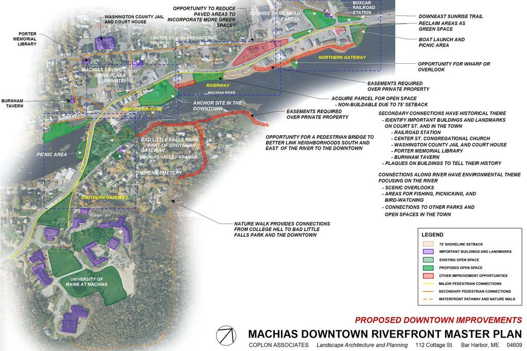
7 Machias Downtown Riverfront Master Plan 4 III. EXECUTIVE SUMMARY The recommended plan for downtown Machias creates additional open spaces and new routes for pedestrian circulation. The park system is improved, expanded and connected via an upgraded pedestrian circulation system. A new continuous recreational trail along the Machias River is proposed to connect the open spaces, and, with a new connection across the Machias River, the trail system can be enlarged and expanded to offer several recreational loops. A historic walk to create a museum in the streets is proposed along Court Street, Free Street and Center Street, identifying and interpreting important buildings and landmarks in the downtown area. The master plan details the recommended improvements in four major sections of town: Southern Gateway Extends from the bottom of the university hill to the intersection of Main Street (Route 192) and Route 1, encompassing Bad Little Falls Park and the Burnham Tavern. Downtown Core Extends from Mobil Station just over the Route 1 Bridge to Bar Harbor Bank & Trust. Riverway Connects the downtown core to the northern end of town, extending from Bar Harbor Bank & Trust to the area past the Irving Station and includes the vacant parcel next to the bank. Northern Gateway Area from the intersection of Route 1 and Court Street to the causeway past Helen s Restaurant. An important recommendation of the plan is to create a feature or anchor in the downtown that will attract people from the university and surrounding neighborhoods. The renovation of the old Ford Garage into a community center or the creation of a large in-town public space in that location would serve this purpose. The development of a pedestrian bridge from a new riverside park near the garage to the east side of the river would greatly improve pedestrian connections from the surrounding neighborhoods and university to the downtown. Streetscape improvements are crucial for the revitalization of the downtown to improve its appearance and appeal. Proposed improvements include new light fixtures in the Downtown Core, new street furnishings including benches and picnic tables, street trees along Route 1 and a comprehensive graphic package for direction, information and interpretation.
8
9 Machias Downtown Riverfront Master Plan 5 IV. DOWNTOWN RIVERFRONT MASTER PLAN Recommendations for improving the function, appearance and appeal of Machias downtown are focused on refinements to several key areas and the pedestrian system that connects them. These areas, as described below, include the Southern Gateway, Downtown Core, Riverway and Northern Gateway A. Pedestrian Circulation Expansion and enhancement of pedestrian circulation is critical to ensuring the integrity and accessibility of the downtown area. The plan envisions a pedestrian circulation hierarchy that includes upgrades to the Route 1 sidewalk, improving connections to and along the river and linking the downtown to the campus and the residential area east of the river. The primary pedestrian system for the downtown area is the existing sidewalk along Route 1 from the university to the boat launch at the north end of town. This walkway provides a continuous connection and is generally in good repair. As illustrated, the master plan upgrades to curb ramps, crosswalks and demarcation of pedestrian zones across parking aprons will allow for improved accessibility, visibility and safety for pedestrians. Cast-in-place concrete is the preferred sidewalk material and a minimum sidewalk width of 4 feet should be maintained. Within the downtown area, a secondary system of sidewalks along Court Street, Free Street and Center Street adjacent to Route 1 provide convenient pedestrian access to a number of Machias historic structures. Through a museum in the streets concept, these buildings can be linked by appropriate signage, allowing for self-guided interpretive walking tours of downtown. From the south, the walk could start at Bad Little Falls Park overlooking the falls, continue to the Burnham Tavern and on to the Porter Memorial Library, Washington County Jail and Court House and the Center Street Congregational Church, terminating at the boxcar and old railroad station across from Helen s Restaurant. A clear, consistent and well-designed sign system and graphic vocabulary will be important to identifying the historic trail and providing connections between landmarks. The plan envisions a new walkway along the river, which would provide opportunities for passive recreation and visual access to the river within the downtown. This proposed walk links existing open spaces along the river extending from the site of the old Ford Garage to the picnic area next to the boat launch. As existing conditions, including available area and embankment material, vary along the route, the walk would consist of an aggregate trail 4 feet in width where space is available and a boardwalk with a handrail, in narrow areas with steep embankments. The majority of the proposed alignment for the trail crosses private property and will require easements from landowners. An expanded nature walk is proposed on the east side of the river connecting Bad Little Falls Park and the University of Maine at Machias. Portions of the walk are already in place and require some additional clearing and widening. The walk should be surfaced with a soft material, such as wood chips. The riverwalk portions of the nature walk cross private property and will require securing access easements from landowners.

10 Machias Downtown Riverfront Master Plan 6 The plan proposes a new pedestrian bridge across the Machias River to link the downtown and riverwalk on the west side of the river with the nature trail and the university campus on the east side. At some point in the future, this bridge would connect the public parking area adjacent to the former Ford Garage on the west side of the river to the existing nature trail on the east. The bridge span would be approximately 220 feet and would allow for a pedestrian loop of approximately 3,600 feet (.68 miles) on both sides of the river. The bridge would offer dramatic up-river views to Bad Little Falls and down-river views to the boat launch and beyond. B. Southern Gateway The southern gateway to downtown Machias begins at the top of university hill where the view of the downtown area unfolds to northbound motorists and pedestrians. The gateway extends across the Route 1 Bridge to the intersection of Main Street (Route 192) and Route 1. New landscaped plaza next to Burnham Tavern Upgrade fence Define clear and accessible entrance to park Improve accessibility and stabilize unsafe areas Upgrade Bad Little Falls Park Existing parking area to be upgraded Existing picnicking and viewing area Figure 1. Conceptual plan for the Southern Gateway.


11 Machias Downtown Riverfront Master Plan 7 Several key issues should be addressed to make the southern gateway more visually appealing, functional and safe for pedestrians and motorists. These issues and recommended solutions are as follows: 1. Clearly establish Southern Gateway The southern edge of the downtown can be more clearly demarcated by new identity, interpretative and directional signage, landscaping and open space improvements. A new gateway sign denoting Historic Downtown Machias and landscaping along the Route 1 corridor would help announce and define the entrance to the downtown. Figure 2. Existing and proposed conditions at intersection of Routes 1 and 192 with the addition of street trees. 2. The adjacency of southbound O Brien Avenue eastward of Route 1 presents safety issues to northbound Route 1 traffic. Installation of trees and shrubs of evergreen plant material (salt-tolerant species such as Eastern white cedar, Blue spruce (figure 3)) in the median between the two roads would effectively be used to screen the view of O Brien Avenue from Route 1 and focus attention on the downtown approach. Careful placement of a downtown gateway sign in this location could also serve to effectively shield the two roads from each other. Provide screening between O Brien Ave and Route 1 New sign welcoming people to the historic downtown Figure 3. Existing and proposed conditions entering the downtown from the south with screening from O Brien Avenue and a new welcome sign.

 will help identify the park from Route 1.")
12 Machias Downtown Riverfront Master Plan 8 3. Access to and visibility of Bad Little Falls Park is limited. Portions of the park are in poor repair and present accessibility issues. Bad Little Falls Park is an important downtown resource. Improving the park s entrance signature and upgrading walkways and facilities for universal access will make the park more appealing and allow it to better function as a primary downtown open space. Development of a new entrance pergola (figure 4) will help identify the park from Route 1. Upgrades to the walkway and viewing platform, including surfacing and railings in conjunction with other landscape improvements, will greatly serve to make the park more attractive to visitors and residents. Upgraded pathways from the east side would allow accessible connection to the gravel parking area on Elm Street, which can be improved by paving and signage. Interpretive signage in conjunction with a self-guided museum in the streets tour identifying other downtown landmarks can celebrate the significance of the site. New pergola to define entrance to Bad Little Falls Park Figure 4. Existing and proposed conditions of the entrance to Bad Little Falls Park. 4. The chain-link fence on the south side of the Mobil Station detracts from the entrance to downtown. Replacement of the chain-link fence by a simple, decorative metal fence (figure 5) would improve the appearance of the southern gateway to town. New metal fence Consolidate signs to improve visibility New crosswalk Figure 5. Existing and proposed conditions on west side of Route 1 bridge with new fence above the retaining wall and relocated signs.
 and Free Street, the Burnham Tavern is one of Machias most significant historic buildings and is a museum")
13 Machias Downtown Riverfront Master Plan 9 5. Celebrate the historic Burnham Tavern Located at the intersection of Main Street (Route 192) and Free Street, the Burnham Tavern is one of Machias most significant historic buildings and is a museum displaying artifacts and memorabilia from the Revolutionary and Civil Wars. The building would serve as a primary destination for the museum in the streets. If possible, purchasing and removing the adjacent building would allow for the development of a new landscaped plaza, contributing to the downtown open space system. New street trees Remove adjacent building to create landscaped plaza Figure 6. Existing and proposed conditions of the Burnham Tavern with the adjacent building removed to create a landscaped plaza. C. Downtown Core Extending from the Mobil Station to Bar Harbor Bank & Trust, the downtown core is an attractive, vibrant place characterized by a dense arrangement of one-, two- and threestory buildings set close to the road. In locations where buildings have been removed, private open spaces have been developed. The area is well served by a network of pedestrian sidewalks that were improved approximately 20 years ago during a downtown revitalization project.

14 Machias Downtown Riverfront Master Plan 10 Figure 7. Conceptual plan for the Downtown Core. Consolidate parking area to create green space along the river Reuse or rebuild old Ford garage as part of new anchor site New pedestrian bridge Some of these improvements are aging or present accessibility issues and are candidates for redevelopment. Several of the key issues facing the downtown core include: 1. Business owners and town staff have identified the midblock curb extensions on the east side of Route 1 as creating problems for parking and snowplowing, with the result being damage to street lights, curbing and paving. Existing fences and walls along the sidewalks can be improved to be more attractive. Removal of these bump-outs will allow for a realignment of parallel parking and the possible addition of three spaces along the east side of the road. Space must be left open in the parking lane for a crosswalk and curb ramp. The sidewalk is relatively narrow in this location (approx 6 feet wide), requiring the midblock streetlight (currently in the curb extension) to be removed, located within the sidewalk or adjacent to a building. A review of the street lighting should be conducted before removal of the curb extension to ensure the lighting solution for this location is compatible with overall downtown lighting strategies. As part of this midblock improvement, the chain-link fence that lines the sidewalk where a building once stood should be replaced with an attractive wood fence that maintains the building line. The concrete wall along the Bangor Savings Bank property on the west side of Route 1 should be resurfaced with a masonry veneer

15 Machias Downtown Riverfront Master Plan 11 or new concrete skim coat. The addition of street trees in strategic locations along Route 1 would improve the appearance and add to the appeal of the downtown. Re-face concrete wall with stone veneer New crosswalk New cast-in-place ADA ramp New street trees Upgrade curb ramp Replace chain-link fence Figure 8. Existing and proposed conditions of downtown Main St. Downtown improvements include refacing concrete wall in front of Bangor Savings Bank, replacing chain-link fence on opposite side of street, removing mid-block curb extensions, and adding street trees. 2. Due to the slope of the road in places, the grades of the sidewalk and curb ramps exceed current accessibility standards. Where practicable, reconstruct sidewalk approaches to meet current accessibility standards. Curb ramp improvements should be included in all roadway/sidewalk and curb reconstruction projects. 3. Old Ford Garage is located in an important downtown location. The building is currently vacant and renovation or reuse of the site will likely require environmental remediation. The building is in a key downtown location and reuse of the building or redevelopment of the site for commercial or public activity is important for economic vitality. One idea that has been promoted is the development of a cultural or community center to attract different age groups and to encourage the college community to spend more time downtown. To promote activity and compliment the future uses at this anchor site, the plan envisions the development of useable open space along the river. A more efficient reconfiguration of the existing parking lot behind the Ford Garage would allow the development of park land along the river. As envisioned, the reconfigured parking lot would contain approx 27 cars as oppose to the 37 it holds today, while allowing the recapture of approx 7,600 square feet (.17 acres) of green space. This new park, containing benches and tables for viewing and picnicking, would create a terminus for the riverway walkway and the new pedestrian bridge across the Machias River.

16 Machias Downtown Riverfront Master Plan 12 Reconfigure existing parking to create new park and picnic area Waterfront pathway Figure 9. Existing and proposed conditions of anchor site in the downtown. Reconfiguring the existing parking area creates an opportunity for a new open space. D. Riverway The riverway extends along the west side of the Machias River from the Old Ford Garage to the boat launch site north of Helen s Restaurant. The walkway improvements envisioned for this area allow for a better-defined and continuous pedestrian connection through the northern section of the downtown. Figure 10. Conceptual plan of Riverway. New river walk New open space with picnic and viewing areas next to Bar Harbor Bank & Trust 1. Improve connections between the downtown core and the causeway at the northern end of town.


17 Machias Downtown Riverfront Master Plan 13 The existing sidewalk along Route 1 is discontinuous and in some locations indistinguishable from the surrounding parking aprons and drives. Clearly demarcating the sidewalk will improve pedestrian safety and identify the importance of pedestrian connections in town. Where feasible, separating the sidewalk from the street edge with a landscape median would create a safer, more attractive pedestrian environment and allow for the planting of street trees. A continuous street tree planting extending through the downtown would help visually integrate the Route 1 corridor, provide a pleasant pedestrian environment and help modulate traffic speed. New striping New landscaped median Figure 11. Existing and proposed conditions looking toward the Northern Gateway with new street trees that provide separation between pedestrian and vehicular traffic. 2. Vacant parcel adjacent to Bar Harbor Bank & Trust Within the shoreland zone where development is limited, this site offers a significant opportunity to create a public park/viewing area adjacent to the river. With benches and picnic tables and other landscaping, this site would create an important recreational node along the riverwalk. Bar Harbor Bank & Trust donated the parcel to the Town in 2008 and reclamation work is scheduled for the summer of New pedestrian bridge Riverwalk Figure 13. Existing and proposed conditions of new river walk connecting to pedestrian bridge at the anchor site.

18 Machias Downtown Riverfront Master Plan 14 E. Northern Gateway Whereas the downtown area has a closely-knit assemblage of buildings that define the road corridor, the northern gateway is largely the reverse, with buildings set back off the road and parking dominating the urban landscape. This area presents the most challenging and interesting opportunities to improve the appearance and function of the downtown and support regional recreational resources: New parking area Boxcar Downeast Sunrise Trail Center Regional recreational trail connection Reclaim as green space New open space Public parking for boat launch and picnic area Enlarge island at intersection Figure 14. Conceptual plan for the Northern Gateway. 1. There is an excess amount of paved area at the south end of the causeway, contributing to a lack of definition to the northern gateway. The area on the west side of the causeway dominated by gravel and broken pavement can be reclaimed as a green space to better define the entrance corridor to town and focus southbound attention on Route 1 and iconic commercial landmarks such as Helen s Restaurant. This open space is adjacent to the historic Railway Station and boxcar that serves as the trailhead for the Downeast Sunrise Trail. Together with potential improvements to landscape around these buildings, a significant new open space could be created as part of the northern entry to downtown Machias. The Downeast Sunrise Trail passes through the causeway open space, offering opportunities to improve awareness and visibility of the trail, interpret its history and significance and serve as an important regional recreational resource to create an important gateway feature to the downtown. In addition, the public boat launch across Route 1 provides easy access to the Machias River and Machias Bay. 2. The intersection of Route 1 and Court Street is unattractive, poorly defined and confusing.

19 Machias Downtown Riverfront Master Plan 15 Reworking of the Court Street/Route 1 intersection could greatly improve the traffic flow, safety and appearance of the north end of town. Removal of some pavement and the installation of landscaped traffic islands can better define traffic flow and turning movements while creating an attractive definition to the Route 1 corridor and Court Street intersection. A careful analysis of the intersection should be conducted by traffic engineers to determine recommended alignments, lane closures and road geometries. Create landscaped island Figure 15. Existing and proposed conditions at intersection of Route 1 and Court Street with enlarged landscaped island and new plantings to create a better-defined traffic pattern. 3. Most of the parking in the area is private. Because Town-owned land is limited, in order to provide adequate parking in this area, the Town can explore working with abutting land owners to create parking that can serve both the Downeast Sunrise Trail and the boat launch.

20 Machias Downtown Riverfront Master Plan 16 V. STREETSCAPE IMPROVEMENTS AND AMENITIES The downtown revitalization calls for a number of streetscape improvements that include new lighting, benches, plantings and paving treatments. The vocabulary of selected site furnishings should be complimentary, providing a coordinated and attractive look to the downtown and Route 1 corridor. A. Lighting The existing decorative streetlights in downtown are in poor repair and consideration should be given to a comprehensive replacement with efficient dark sky friendly fixtures. Prior to purchasing new streetlights, it is recommended that a thorough lighting study be conducted to determine lighting needs and recommend fixture types, height locations, etc. B. Benches, Tables and Trash Receptacles Benches should be of traditional design with cast iron frame and wood slats, between 6 to 8 feet in length. Benches should be located in picnic and viewing areas, and under trees. They can also be located along the sidewalks, provided there is no interference with walking areas. Picnic tables should be of classic design made of either wood or metal. Tables should be 6 feet in length and be located in park areas. Trash receptacles should compliment the benches and tables in material and design. They should be durable, metal with a black powder-coated finish; a 35-gallon size is typical and should be located near intersections, benches and picnic areas. Locations and design of furnishings should be coordinated during the design phase of the project. Figure 16. Examples of traditional site furnishings. C. Paving Treatments Removing the midblock bump-outs will require new curbing to be set. Curbing should be granite and selected to match the existing curbing. Sidewalk pavers should be reused as necessary to fill in any voids from construction. ADA ramps are to be provided at all crosswalk locations, and are to be cast-in-place concrete with detectable warnings. Painted crosswalks should highlight all pedestrian crossings on roadways. D. Street Trees Street trees are essential to creating an inviting and attractive downtown. The selection of appropriate species and proper planting methodologies are critical to ensuring the long-term vigor of street trees. Street trees will be chosen to either create a high canopy that extends over roads and surrounding buildings so as not to obscure signage and views, or to provide a narrow, tight canopy that creates a formal edge to the road. A narrow, tighter canopy is recommended in the denser parts of the downtown to avoid buildings and aerial utility lines. This will create separation between pedestrian and
21 Machias Downtown Riverfront Master Plan 17 vehicular traffic and strengthen the connections to the Northern and Southern Gateways. Trees selected for planting in urban environments must be drought, heat and salt tolerant, as well as native species. Plant hardiness for Machias is USDA Zone 4 and several recommended species include: Street Trees o Acer rubrum Red Maple Var. Armstrong is upright and narrow. o Tilia cordata Littleleaf Linden Park Trees o Acer rubrum Red Maple o Acer saccharinum Silver Maple o Betula nigra River Birch Var. Heritage o Prunus serotina Black Cherry o Quercus palustris Pin Oak not recommend for use as street tree o Quercus rubra Red Oak o Ulmus parviflora Lacebark Elm Planting trees in the downtown area will require excavation for tree pits of sufficient size to allow root growth. In areas outside of the downtown core where conditions are not as constricting, it is recommended to plant trees in continuous landscaped bays to offer trees the greatest opportunity for growth and long-term health. E. Signage The ability to announce, identify and locate important destinations is essential to the success of a downtown. Signage plays a key role in this wayfinding process. It is recommended that Machias develop a comprehensive signage program to identify its key downtown resources. This signage falls into three general categories: gateway, way-finding/interpretational and locational. Gateway signage should be placed at the Southern and Northern Gateways to welcome people to historic downtown Machias. These signs should be large enough to be visible to vehicles approaching downtown. Way-finding and interpretative signage are suitable to identify historic buildings and places and locational signage is suitable to tell the story of a specific site. There should be a unifying graphic vocabulary or theme to the signs, uniting the larger roadway entry signage to the smaller on-site interpretive signs. As has been done in many other communities, it is recommended that a graphic designer with experience in municipal signage and interpretation be retained to develop a comprehensive signage package for Machias.
22 Appendix A Machias Downtown and Riverfront Master Plan Conceptual Design Cost Estimate Southern Gateway Improvements Item Quantity Unit Unit Cost Item Total Subtotal Remarks Purchase and Removal of Building allow $165, $165, Building Demolition and Removal allow $35, $35, Landscaped Plaza 3200 SF $35.00 $112, stone plaza adjacent to Burnham Tavern Signage 1 EA $ $ Sign marking Southern Gateway Fence Improvements 180 LF $75.00 $13, Replace chain-link fence at Mobil Station Evergreen Plantings 7 EA $ $4, Screening between Rt. 1 and O'Brien Ave. Shrub Plantings 6 EA $75.00 $ Planting between Rt. 1 and O'Brien Ave.; shrubs behind fence at Mobil Station Subtotal $330, Estimating Contingency (20%) $66, Southern Gateway Total $396, Bad Little Falls Park Improvements Item Quantity Unit Unit Cost Item Total Subtotal Remarks Trellis at Park Entrance allow $15, $15, Wood trellis to mark entrance to the park along Rt. 1, approx. 8' x 20' x 8' Walk Improvements 300 LF $25.00 $7, Resurface walk areas from Rt. 1 bridge to Elm St. with new aggregate and reset edging Replace Railing 170 LF $75.00 $12, Replace rail and repair concrete at spillway to meet ADA requirements; excludes existing wood stage area Subtotal $35, Estimating Contingency (20%) $7, Bad Little Falls Park Total $42, Nature Walk Improvements Item Quantity Unit Unit Cost Item Total Subtotal Remarks Trail Improvements 6,580 LF $20.00 $131, Assume 4' wide trail; clear and grub, base and surface trail from Bad Little Falls Park (Elm St. entrance) along eastern side of Machias River and circumnavigate UMM Signage 7 EA $ $1, Way-finding interpretive signage Subtotal $133, Estimating Contingency (20%) $26, Nature Walk Total $160, Anchor Site Improvements Item Quantity Unit Unit Cost Item Total Subtotal Remarks Pavement Removals allow $2, $2, Consolidate parking lot to maintain same number of spaces and remove excess pavement Loam and Seed 34,500 SF $0.60 $20, Loam and seed areas around old Ford Garage and where pavement was removed Benches 4 EA $ $2, New benches along riverfront Picnic Tables 6 EA $ $4, Trash Receptacles 3 EA $ $ Evergreen Plantings 10 EA $ $6, Screening from adjacent properties Shade Tree Plantings 12 EA $ $7, Specimen trees Subtotal $45, Estimating Contingency (20%) $9, Anchor Site Total $54, Riverwalk Improvements Item Quantity Unit Unit Cost Item Total Subtotal Remarks Aggregate Walk Along River 1,850 LF $20.00 $37, Assume 4' width Boardwalk Along River 600 LF $ $90, Assume 4' width with handrail Clearing and Grubbing allow $2, $2, Clear newly acquired parcel next to Bar Harbor Bank, leaving large trees Loam and Seed 18,700 SF $0.60 $11, Loam and seed parcel for new park area Benches 5 EA $ $3, New benches along riverfront Picnic Tables 6 EA $ $4, Tables in vacant parcel and by boat launch Trash Receptacles 2 EA $ $ Evergreen Plantings 10 EA $ $6, Screening from adjacent properties Shade Tree Plantings 10 EA $ $6, Specimen trees for park area Signage 4 EA $ $1, Way-finding interpretive signage Subtotal $162, Estimating Contingency (20%) $32, Riverwalk Total $195,144.00
23 Main Street Improvements Item Quantity Unit Unit Cost Item Total Subtotal Remarks Demolition and Removal of Mid-block Leave end bump outs and eliminate middle ones Bump Outs allow $10, $10, New Curbing 150 LF $35.00 $5, Reset new curb where bump outs were removed ADA Ramp Improvements 4 EA $1, $6, Provide ADA compliant ramp at all crosswalk and crossing locations with new curb Re-face Concrete Wall 280 SF $ $42, Stone veneer on retaining wall in front of Bangor Savings Bank, approx. 70' long x 4' high Lighting 12 EA $3, $42, Replace lights with new fixtures along Main St. New Wood Fence 50 LF $75.00 $3, Replace chain-link fence across from Bangor Savings Bank Plantings 80 EA $ $52, Street trees from Burnham Tavern to boat launch Misc. Street Improvements allow $15, $15, Benches, tree grates, etc. Subtotal $161, Estimating Contingency (20%) $32, Main Street Total $193, Northern Gateway Improvements Item Quantity Unit Unit Cost Item Total Subtotal Remarks Pavement Removals allow $2, $2, Remove striped island at intersection of Main St. and Court St.; remove pavement around existing island to expand landscaped area; maintain traffic pattern New Curbing 340 LF $35.00 $11, Curbing around landscaped islands Loam and Seed 1,500 SF $0.60 $ Loam and seed islands at Main St. and Court St. intersection Pavement Removals allow $3, $3, Remove parking area across from Helen's Restaurant Loam and Seed 11,300 SF $0.60 $6, Loam and seed existing parking area across from Helen's Restaurant Clearing and Grubbing allow $2, $2, Clear area behind boxcar Asphalt Paving 80 ton $ $12, car parking area behind boxcar Loam and Seed 12,100 SF $0.60 $7, Loam and seed area adjacent to new parking lot Loam and Seed 38,700 SF $0.60 $23, Reclaim area adjacent to train station as greenspace Benches 4 EA $ $2, Picnic Tables 4 EA $ $3, Trash Receptacles 2 EA $ $ Signage 1 EA $ $ Sign marking Northern Gateway Shade Tree Plantings 25 EA $ $16, Specimen trees Subtotal $93, Estimating Contingency (20%) $18, Northern Gateway Total $112, Downtown Signage Improvements Item Quantity Unit Unit Cost Item Total Subtotal Remarks Way-finding Interpretive Signage 10 EA $ $2, Signage identifying public parking and directions to significant buildings Interpretive signage describing town's history and historic buildings, including Burnham Tavern, Porter Memorial Library, Centre St. Church, Washington County Jail and Court House, and Train Station Historical Buildings and Places 5 EA $ $1, Subtotal $4, Estimating Contingency (20%) $ Signage Total $4, Pedestrian Bridge Improvements Item Quantity Unit Unit Cost Item Total Subtotal Remarks Bridge Crossing 1 EA $450, $450, ' span across Machias River linking trails Subtotal $450, Estimating Contingency (20%) $90, Bridge Total $540, Project Total $1,699,296.00
Table of Contents. Elm Avenue Improvement Plan City of Waco, Texas. Introduction 1. Existing Context 1 Figure 1 2.
 Table of Contents Introduction 1 Existing Context 1 Figure 1 2 Plan Guidelines 3 Future Urban Form 4 The West-End 4 Main Street 6 The East-End 7 Figure 2 9 Public Improvement Recommendations 7 General
City of Farmington. Downtown Plan. Amendment to the 1998 Master Plan Adopted October 11, 2004
 City of Farmington Amendment to the 1998 Master Plan Adopted October 11, 2004 Introduction Planning Background 1 Scope and Components of the Plan Amendment 2 Concept Introduction 3 Plan Concepts 3 Conceptual
VEHICULAR AND PEDESTRIAN CIRCULATION
 This perspective sketch communicates the intended character and quality of a proposed streetscape design. Locate benches near a major intersection where people tend to gather. Seating and lighting provide
BRADENTON RIVERWALK EXPANSION MASTER PLAN
 BRADENTON RIVERWALK EXPANSION MASTER PLAN INTRODUCTION & AGENDA Process Update Community Engagement Summary Center for Active Design (CfAD) Recommendations Context and Existing Conditions Master Plan Alternatives
BUSINESS DISTRICT DESIGN GUIDELINES
 Des Plaines, Illinois Prepared for the City of Des Plaines by: The Lakota Group Laurie Marston, AICP March 2005 Section 5: Streetscape Elements Business District Design Guidelines STREETSCAPE ELEMENTS
R STREET CORRIDOR NEIGHBORHOOD Site Plan and Design Review Supplemental Guidelines Checklist
 R STREET CORRIDOR NEIGHBORHOOD Site Plan and Design Review Supplemental Guidelines Checklist Applicant s Name: Project Address: Phone: Email: Applicant shall fill out the design guidelines checklist for
GREENING THE BOULEVARD Master Plan Concepts for Venice Boulevard between Lincoln and Sawtelle
 GREENING THE BOULEVARD Katherine Spitz Associates Inc. 4212½ Glencoe Avenue Marina Del Rey, CA 90292 310 574 4460 Fax 574 4462 January 2008 Table of Contents Overview Proposed Design Improvements Illustration
PUBLIC RIGHT-OF-WAY IN THIS CHAPTER PUBLIC REALM
 PUBLIC RIGHT-OF-WAY This section provides design guidelines for improvements in the public right-of-way. The public right-of-way refers to streets, sidewalks, non-vehicular thoroughfares, parks and greenways
A. Background Summary of Existing Challenges and Potential Possibilities. 1. Summary of Existing Assets and Potential Opportunities
 A. Background 1 A Main Street Master Plan Study was performed and completed in October of 2007. The study was initiated to review current land uses and development patterns along Main Street, from Parrish
Fifth and Detroit Street Design May 2017 Capital Improvements Committee. DOWNTOWN Street Design
 1 Fifth and Detroit Street Design May 2017 Capital Improvements Committee Agenda 2 Review Street Configuration Prior Meeting Review Outreach Synopsis Functional Street Design Refinements Curb Edge, Turning
appendix and street interface guidelines
 appendix five: building and street interface guidelines appendix 5 building and street interface guidelines BOULEVARDS Boulevards are generally characterized by higher levels of traffic movement at higher
The Auburn Plan Designing the Future of Auburn February 28, 2005
 The Auburn Plan Designing the Future of Auburn February 28, 2005 Block-by-Block Bicycle Tour Aerial survey Focus Group Meetings September 7 and 8 Design Workshops October 11, 14, and 21 Revitalization
CHAPTER 3. Design Standards for Business, Commercial, Industrial, Recreational and Institutional Uses
 CHAPTER 3 Design Standards for Business, Commercial, Section Number Title Ordinance Number Date of Ordinance 16-3-1 Applicability 2006-11 2008-04 07-01-08 16-3-2 Uniform Standards for Architectural Design
Illustration of Eastlake Farmer s Cooperative Grain Elevator. Chapter 5: implementation 5-1
 Illustration of Eastlake Farmer s Cooperative Grain Elevator Chapter 5: implementation 5-1 chapter 5: implementation Introduction The Eastlake Subarea Plan includes a wide range of recommendations intended
VILLAGE OF SKOKIE Design Guidelines for Mixed-Use Districts NX Neighborhood Mixed-Use TX Transit Mixed-Use CX Core Mixed-Use
 VILLAGE OF SKOKIE Design Guidelines for Mixed-Use Districts NX Neighborhood Mixed-Use TX Transit Mixed-Use CX Core Mixed-Use TABLE OF CONTENTS CHAPTER 1 SITE DESIGN Purpose 1 CHAPTER 2 SITE DESIGN Streetscape
Clairtrell Area Context Plan
 Clairtrell Area Context Plan March 2005 Urban Development Services City Planning Contents 1. Introduction... 4 2. Development Structure... 6 2.1 Streets... 7 2.1.1 Sheppard Avenue and Bayview Avenue...
section five BEAUTIFICATION PLAN
 section five BEAUTIFICATION PLAN BEAUTIFICATION PLAN Section Five Beautification Plan The goal of the Beautification Plan is to improve the Route 8-Sunnyland Corridor in terms of aesthetics and to create
SECTION TWO: Urban Design Concepts
 SECTION TWO: Urban Design Concepts The Gardnerville Plan for Prosperity shapes economic opportunities presented by regional growth. The Urban Design Concepts provide policies and concepts for land use,
GYPSUM PARKWAY CORRIDOR ENHANCEMENT Gypsum, Colorado. Schematic Design January 2015
 GYPSUM PARKWAY CORRIDOR ENHANCEMENT Gypsum, Colorado Schematic Design January 2015 1 2 3 4 5 6 7 8 9 DESIGN WORKSHOP Landscape Architecture Land Planning Urban Design Tourism Planning Asheville Aspen Austin
The Vision. Photo provided by The Minervini Group. 46 Vision, Objectives & Strategies
 Vision, Objectives & Strategies The is the public framework and guide for future development of the Grand Traverse Commons. The establishes public polices for infrastructure, the preservation of natural
ROME WATERFRONT VILLAGE PROJECT NARRATIVE January 25, 2018
 January 25, 2018 The Rome Waterfront Village project is intended to foster the revitalization of the area between South James Street and Erie Boulevard north of the Erie Canal as well as improve public
The open space system should provide connective elements, relate to natural resources, and enhance the suburban character of the landscape..
 The open space system should provide connective elements, relate to natural resources, and enhance the suburban character of the landscape.. Mixed-use and infill development should maintain or enhance
Figure Example of out door dining in the public right-of-way.
 Section 2 Core Area Goal 2.2.1 To maintain and enhance the character of existing streets in the Downtown Area. Character Figure 2.2.1 Example of out door dining in the public right-of-way. A. Provide street
APPENDIX D: Visual and Aesthetic Conditions for NCCU Station Refinement. Durham-Orange Light Rail Transit Project
 APPENDIX D: Visual and Aesthetic Conditions for NCCU Station Refinement Durham-Orange Light Rail Transit Project October 2016 1. Introduction The Combined FEIS/ROD summarizes the effects of the D-O LRT
THE CIVIC DISTRICT DEVELOPMENT OPPORTUNITIES
 1 THE CIVIC DISTRICT DEVELOPMENT OPPORTUNITIES The Civic District is the physical and emotional heart of the downtown. It is also a major gateway into the central core, establishing the image and identity
COMPLETE GREEN STREET CHECKLIST
 COMPLETE GREEN STREET CHECKLIST This document was developed to dissect the structure of an urban street and explore opportunities to make our streets more complete while also integrating green street strategies.
Design Guidelines for the Route 30 Corridor Master Plan: Subdivision and Land Development Elements
 Design Guidelines for the Route 30 Corridor Master Plan: Subdivision and Land Development Elements East Whiteland Township- Chester County, PA Prepared by: Draft: May 7, 2018 Design Guidelines for the
V. Gateways GATEWAYS / V-1
 V. GATEWAYS / V-1 Many of Chesapeake s gateways are located on highways and call for bold and attractive designs that motorists can understand, appreciate, and enjoy. can also take the form of natural
Concluding Improvement Recommendations and Opinions of Probable Cost (calculated in may 2010 construction rates).
.") Pelican Bay Community Improvement Plan Traffic,JI Concluding Improvement Recommendations and Opinions of Probable Cost (calculated in may 2010 construction rates). D1 -A: Provide consistent signing, marking
Pelican Bay Community Improvement Plan Traffic,JI Concluding Improvement Recommendations and Opinions of Probable Cost (calculated in may 2010 construction rates). D1 -A: Provide consistent signing, marking
Seneca Meadows. Block 4 Locate office, technology, and medical development adjacent to I Screen views of garage structures from I-270.
 Seneca Meadows Seneca Meadows has an industrial park in its southern end and a mixed-use employment area planned for the north end. The district benefits from extensive I-270 visibility, stream valley
Civic Center District
 Civic Center District The Civic Center district is the civic and social heart of Warrenville, containing such public buildings as the City Hall, Warrenville Public Library, Police Station, Park District
Project Consulting Team:
 THE DOWNTOWN CHERRYVILLE LAND USE + STREETSCAPE MASTER PLAN WAS FUNDED THROUGH THE GENEROUS DONATIONS OF THE FOLLOWING: The Community Foundation of Gaston County ElectriCities of North Carolina The Cherryville
Maplewood Avenue Downtown Complete Street Project
 Maplewood Avenue Downtown Complete Street Project Second Public Meeting January 24, 2018 Welcome and Introduction of Project Team City Planning and Public Works Staff City of Portsmouth Juliet Walker Planning
FLORIN ROAD CORRIDOR Site Plan and Design Review Guidelines Checklist
 FLORIN ROAD CORRIDOR Site Plan and Design Review Guidelines Checklist Applicant s Name: Project Address: Phone: Email: Applicant shall fill out the design guidelines checklist for all guidelines applicable
WEST LOOP DESIGN GUIDELINES CHECKLIST
 WEST LOOP DESIGN GUIDELINES CHECKLIST Section 1.0 General Strategies 1.1 DESIGN EXCELLENCE: ENCOURAGE HIGH QUALITY AND INNOVATIVE DESIGN OF NEW BUILDINGS WITHIN THE WEST LOOP WITHOUT BEING PRESCRIPTIVE
Policies and Code Intent Sections Related to Town Center
 Policies and Code Intent Sections Related to Town Center The Town Center Vision is scattered throughout the Comprehensive Plan, development code and the 1994 Town Center Plan. What follows are sections
E c o n o m i c D e v e l o p m e n t
 convenient location in town to leave the old jail site available for redevelopment. Action 6: Redevelop the county volunteer fire department site. The relocation of the volunteer fire department is in
The transportation system in a community is an
 7 TRANSPORTATION The transportation system in a community is an important factor contributing to the quality of life of the residents. Without a sound transportation system to bring both goods and patrons
Our Legacy Projects DOWNTOWN JACKSONVILLE MASTER PLAN
 DOWNTOWN JACKSONVILLE MASTER PLAN A major component of our master plan is the creation of a strong and accessible open space and recreation system. The four most vital links in that system are our legacy
2.5 Roads. Loading and service areas adjacent to Highway 401 should be screened through architectural walls and/or landscape buffer planting.
 N HIGHWAY OFF RAMP 2.5 Roads A legible road network with a clear hierarchy will help create a connected community, both within and surrounding the Milton Heights. The following section outlines the proposed
Corridor Identity. Section 9. Introduction. Corridor Guiding Principles
 Corridor Identity An attractive and healthy community is a critical element of a quality place, and the design of quality places is a balance between environmental, economic, and social considerations.
PIQUA OHIO PLACEMAKING INITIATIVE
 PIQUA OHIO PLACEMAKING INITIATIVE A HANDBOOK to understanding the Placemaking Initiative for Piqua, Ohio June 15 2016 GAMBLE ASSOCIATES urban design BOOKER DESIGN COLLABORATIVE landscape architecture CITYVISIONS
FREEWAY/TOURIST DISTRICT
 FREEWAY/TOURIST DISTRICT DESIGN STANDARDS FOR THE CITY OF MOUNTLAKE TERRACE March, 2014 MOUNTLAKE TERRACE FREEWAY/TOURIST DESIGN STANDARDS March, 2014 1 TABLE OF CONTENTS Introduction...1 Design Site Design
SOUTH UNIVERSITY Street Design Alternatives in Progress
 1 Alternatives in Progress 2016.01.20 Meeting Agenda 2 1. Progress & Schedule 2. Utilizing the Street Design Manual 3. Site Characteristics and Input Received 4. Street Geometry What can we accomplish
Town Center (part of the Comprehensive Plan)
") Town Center (part of the Comprehensive Plan) Mercer Island Town Center Looking North (2014) In 1994, a year-long process culminated in a set of design guidelines and code requirements for the Town Center
Town Center (part of the Comprehensive Plan) Mercer Island Town Center Looking North (2014) In 1994, a year-long process culminated in a set of design guidelines and code requirements for the Town Center
Project Goal. RRRC Living Towns Planning Workshp. Town of Halifax Revitalization Project. Dynamic Planning & Management Duo: July 12, 2006
 Project Goal Town of Halifax Revitalization Project RRRC Living Towns Planning Workshp July 12, 2006 Town of Halifax Halifax County *** Revitalization Project Goal*** To create Economic Opportunity and
Town Center. Block 5 Existing multifamily residential units are expected to remain.
 Area Guidelines Germantown s districts should be developed as distinct communities with unique features that are supported through the guidelines. The guidelines not only help distinguish these districts
4.9 Mendocino Avenue Corridor Plan Design Guidelines
 4.9 Mendocino Avenue Corridor Plan Design Guidelines The Mendocino Avenue Corridor Plan addresses the area between College Avenue and Steele Lane. Mendocino Avenue is a busy arterial that runs parallel
Chapter 14 Streetscape Improvements
 This chapter presents streetscape design concepts for key streets and gateways in the Downtown Specific Plan area. This chapter is organized as follows: 14 Streetscape Improvements 14.1 Streetscape Treatments
STREETSCAPE IMPROVEMENTS - RECOMMENDATIONS
 STREETSCAPE IMPROVEMENTS - RECOMMENDATIONS Figure 4.3.1- A map of all of the recommended streetscape improvements. The key component of downtown s public realm, apart from its public spaces, is its street
ELMVALE ACRES SHOPPING CENTRE MASTER PLAN
 ELMVALE ACRES SHOPPING CENTRE MASTER PLAN Contents 1.0 INTRODUCTION... 2 2.0 LOCATION... 2 3.0 EXISTING CONTEXT... 2 4.0 VISION & GUIDING PRINCIPLES... 2 5.0 LAND USE AND BUILT FORM... 4 5.1 St. Laurent
2011 ASLA Design Awards. Centennial Park Merit Award Design Concepts CLA, Inc. Design over $500,000 Construction Budget
 2011 ASLA Design Awards Centennial Park Merit Award Design Concepts CLA, Inc. Design over $500,000 Construction Budget 2011 ASLA Colorado Professional Design Awards Project Name: Category: Location: Const.
Urban Analysis. Downtown Zanesville like any city, has been physically modified through time as it
 Urban Analysis As a part of the consulting team s reconnaissance effort, an urban analysis was performed. Before the future of a place can be envisioned, one must understand the physical characteristics
F. Driveways. Driveways which provide access to off-street parking or loading from public streets shall comply with the following:
 Section 20.945.040 General Design Standards for Surface Parking Areas. A. Review Authority. Parking lot design and drainage shall be subject to review and approval of the City Transportation Manager. B.
chapter DESIGN GUIDELINES NEW RIVER MASTER PLAN REPORT
 chapter DESIGN GUIDELINES NEW RIVER MASTER PLAN REPORT .76 DESIGN GUIDELINES An Overview design guidelines NEW RIVER MASTER PLAN Design Guidelines can transform the image of a city. Specific, design-based
NORTH COLLEGE PARK. Residential Neighborhood and Neighborhood Center OBJECTIVES EXISTING SITUATION AND ISSUES CONCEPT
 Greenbelt Metro Area Sector Plan - Subarea Design Policies and Guidelines - North College Park 119 NORTH COLLEGE PARK Residential Neighborhood and Neighborhood Center CONCEPT North College Park is envisioned
3.0 master plan concept
 3.0 master plan concept 3.1 introduction The purpose of the Huron Church Road Master Plan Concept is to provide an overview of the Master Plan design process, identify preliminary streetscape installations
Roanoke Rapids Streetscape Master Plan. City Council Presentation
 SCHEDULE: Stakeholder Meeting/Kick off November,2016 Master Planning Phase (November March 2017) Public Meeting #1 December 13, 2016 Review Meeting with Key Stakeholders Refine Concepts Based on Input
Reconnecting to a Forgotten River St. Cloud MN. Aaron Hanson Design Design Thesis LA 572, Thesis, Spring 2012
 Reconnecting to a Forgotten River St. Cloud MN Aaron Hanson Design Design Thesis LA 572, Thesis, Spring 2012 site context 2.5 Miles Sartell St. Cloud to Fargo 170 Miles (2 hrs 45 mins) Hwy 10 infrastructure
Hockessin Community Redevelopment Plan
 Hockessin Community Redevelopment Plan 3.1 Introduction The Community Redevelopment Plan for the Village of Hockessin is the result of the people s vision for a distinct village center that serves as the
Preliminary Sketch Plan for Fort Hunter Park
 Preliminary Sketch Plan for Fort Hunter Park Public Presentation November 19, 2009 Dauphin County Parks and Recreation 100 Fort Hunter Road Harrisburg, PA 17110 (717) 599-5188 www.dauphinc.org THOMAS COMITTA
DRAFT ROOSEVELT ROAD. District Recommendations. Figure 5.23 The Roosevelt Road Corridor
 CHAPTER 5 Figure 5.23 The Road Corridor Road will develop as a mixed-use corridor, emphasizing regional retail, west of the river and mixed-use development east of the river. KEY RECOMMENDATIONS 1. High
Landscape and Streetscape Design 2.5
 Landscape and Streetscape Design 2.5 2.5.1 Goals 2.5.2 Planting 2.5.3 Sidewalks and Pavement 2.5.4 Furnishings 2.5.5 Walls 2.5.6 Lighting 2.5.7 Stormwater 2.5.8 Street Cross Sections 2.5 LANDSCAPE AND
5.0 P A R K R E C O M M E N D A T I O N S
 5.0 P A R K R E C O M M E N D A T I O N S 5.1 Confederation Park The analysis of Confederation Park recognizes that it, along with City Hall, is the symbolic heart of Kingston. While the existing layout
Grafton Street < N September 2, 2015
 Grafton Street < N September 2, 2015 Project Background, Site Inventory + Analysis Brunswick Street Duke Street Scotia Bank Centre Carmichael Street Argyle Street City Hall Grand Parade Barrington Street
Rundel Library Elevated River Terrace Reconstruction City of Rochester, N.Y. Application Number July 2017
 Rundel Library Elevated River Terrace Reconstruction City of Rochester, N.Y. Application Number 75047 July 2017 PROJECT DESCRIPTION The Rundel Library is a nationally registered historic building surrounded
Community Design Plan
 Gardena General Plan 2006 Authority While the is not a required element of a General Plan, it is included because improving the community appearance and image is paramount to the overall quality of life
Highland Village Green Design Guidelines
 Highland Village Green Design Guidelines Publishing Information Title Highland Village Green Design Guidelins Author The City of Calgary Status DRAFT - Proposed document subject to changes Additional Copies
Below the trestle lie artifacts of past industry along the Cobbossee Stream. South end of the trestle, at the proposed trailhead area.
 The existing railroad trestle, when refitted as a pedestrian walkway, could be an important, eye-catching, scenic component to the Cobbossee Stream Trail. South end of the trestle, at the proposed trailhead
open house 3 CITY OF SALEM Downtown Streetscape Plan
 open house 3 Streetscape concepts CITY OF SALEM Downtown Streetscape Plan analysis concepts we are here refined concepts & document Feb 13th 1 2 3 apr 18th KICKOFF OPEN HOUSE Streetscape Work Group Walking
Jewel. Platte. of the. Plattsmouth Main Street Landscape Architecture by HDR
 Jewel of the Platte Plattsmouth Main Street Landscape Architecture by HDR Plattsmouth, Nebraska is a historic community of 6,500 residents located along the west bank of the Missouri River, just south
Preci nct P l ans Figure 56 Campus Aerial Photo, 2008 CAL STATE EAST BAY, HAYWARD CAMPUS MASTER PLAN
 9 Precinct Plans This section contains a detailed discussion of the planning and design concepts for specific areas or precincts of the Cal State East Bay Hayward campus. The Precinct Plans pertain to
Wayfinding. North Gateway: Integrate a vertical gateway marker on the west side of Ward Street at the south corner of Vernon Street.
 3.3.6.2 Wayfinding Existing Conditions Wayfinding signage is important to direct visitors and tourists to different locations in the downtown. A significant part of the wayfinding signage in the downtown
PHASE 3-4 PARKS SOUTH PARK AND CHANNEL PARK
 PHASE 3-4 PARKS SOUTH PARK AND CHANNEL PARK Sheet List L1.0 L2.0 L3.0 L4.0 L5.0 L6.0 L7.0 L8.0 L9.0 L10.0 L11.0 L12.0 L13.0 L14.0 L15.0 L16.0 L17.0 L18.0 L19.0 L20.0 L21.0 L22.0 Cover Open Space Context
WATERFRONT DISTRICT DESIGN STANDARDS
 WATERFRONT DISTRICT DESIGN STANDARDS 20.25.080 WATERFRONT DISTRICT A. Purpose. This section is intended to implement The Waterfront District Subarea Plan by: 1. Creating a safe, vibrant mixed-use urban
TOWN COUNCIL / PLANNING COMMISSION
 Workshop #3 TOWN COUNCIL / PLANNING COMMISSION January 20, 2011 Consultant Team In Attendance Tonight BMS Design Group Nevada City and San Francisco Michael Smiley, AICP, ASLA Partner-in-Charge Nancy L.
AIRPORT BUSINESS PARK
 PIER MAC PETROLEUM INSTALLATION LTD. AIRPORT BUSINESS PARK DEVELOPMENT APPLICATIONS March 2003 4.1 Airport Business Park Development Permit Area 4.1.1 Justification/Design Concept The design concept envisioned
Main Street Reconstruction From Ninth Line to Stouffer Street. Town of Whitchurch-Stouffville. Public Information Centre
 Main Street Reconstruction From Ninth Line to Stouffer Street Town of Whitchurch-Stouffville Public Information Centre November 23, 2016 4:30 to 6:00 pm & 7:00 to 8:00 pm 6240 Main Street, Stouffville
Design Considerations
 Essential to the development of a successful Master Plan for the Park Complex is input from the community that the park will serve. The community outreach component of the planning process included numerous
Downtown Papillion. Concepts for the Enhancement and Growth of Papillion s Traditional Town Center
 Downtown Papillion Concepts for the Enhancement and Growth of Papillion s Traditional Town Center Developed for the City of Papillion by RDG Planning & Design T raditional downtown districts occupy a particular
URBAN DESIGN BRIEF REPORT
 URBAN DESIGN BRIEF REPORT PREPARED FOR 2568401 ONTARIO INC NEW GASBAR, CONVENIENCE STORE & CARWASH DEVELOPMENT @ 1509 FANSHAWE PARK ROAD WEST LONDON, ONTARIO GAMA ENGINEERING INC. PROJECT NUMBER 1669 PREPARED
II. SINGLE FAMILY RESIDENTIAL
 II. SINGLE FAMILY RESIDENTIAL Castle Rock is made up of numerous individually built houses and subdivision tracts that have been developed during the past century. Some of the tracts are diverse in architectural
Transportation. Strategies for Action
 Transportation A major priority for the Overlake Neighborhood is to develop a multimodal transportation system. To achieve this system, a balance has to be found among travel, circulation and access needs;
Planning Board Briefing
 Planning Board Briefing Why Now? The Sector Plan Implementation Chapter States: Before Stage 1 begins, the following must occur: Approval of the Sectional Map Amendment. Approval of the Greater Lyttonsville
B L A C K D I A M O N D D E S I G N G U I D E L I N E S for Multi-family Development
 B L A C K D I A M O N D D E S I G N G U I D E L I N E S for Multi-family Development Adopted June 18, 2009 This section of the Design and focuses on site planning and design guidance for new multi-family
WINDSOR GLEN DESIGN GUIDELINES
 WINDSOR GLEN DESIGN GUIDELINES Adopted by Council, 2006 WINDSOR GLEN REDEVELOPMENT DESIGN GUIDELINES August 2006 1.0 Master Plan Organization For this area of the Coquitlam Town Centre, a mix of high,
Gas Works Site Land-Use Study
 City of New Westminster Background Context 2 Neighbourhood Context 3 Program Elements 4 Proposed Site Planning Approach 5 Design Rationale 10 Design Elements 11 Phasing 21 C o n t e n t s b a c k g r o
The Capital Design Advisory Committee St. Mary s College of Maryland & Historic St. Mary s City
 The Capital Design Advisory Committee St. Mary s College of Maryland & Historic St. Mary s City Welcome April 21, 2010 Capital Design Advisory Presentation: Relocating Margaret Brent Hall Traffic Calming
Hamilton Road Corridor Streetscape Master Plan. Open House October 4 th, 2017
 Hamilton Road Corridor Streetscape Master Plan Open House October 4 th, 2017 Agenda 1. Introductions Agenda Overview 2. Project Background 3. Existing Conditions 4. Strengths, Weaknesses, Opportunities
Potential Green Infrastructure Strategies May 6, 2015 Workshop
 Potential Green Infrastructure Strategies May 6, 2015 Workshop Background The City of Cortland is developing the Tioughnioga Urban Headwaters Green Infrastructure Action Plan with funding from the National
Public input has been an important part of the plan development process.
 Lakewood s Comprehensive Plan recognizes that transportation helps shape the community, and that the way the community provides for the safe and efficient movement of people affects the character of the
Popp s Ferry Causeway Park Back Bay Environmental Educational Center CASHIO COCHRAN LLC
 Popp s Ferry Causeway Park Back Bay Environmental Educational Center CASHIO COCHRAN LLC A LIMITED LIABILITY COMPANY Popp s Ferry Causeway Park Master Plan Prepared for: City of Biloxi Department of Parks
Downtown Dubuque...it s a great time.
 Downtown Dubuque...it s a great time. Your timing could not be better to invest in Downtown. With hundreds of millions in public and private investment occurring on the City s downtown waterfront, millions
Streetscape Patterns. Design Guidelines, Ridgewood Village Center Historic District, Ridgewood, N.J. page 20
 North Broad Street has a unique streetscape pattern with broad curving street, tight enclosure on the east side with attached commercial buildings aligned with the sidewalk, and landscaped open space on
Berkshire Regional Planning Commission Clearinghouse Review Report
 August 19, 2013 SUBJECT: Reconstruction of Housatonic Street, Dalton, MA EOEA#: 15083 LOCATION: Dalton ESTIMATED COST: $8.1 million REVIEW TYPE: ENF PROPONENT: MassDOT and Town of Dalton COMMENTS DUE:
Landscape Design Guidelines
 Section 7: Landscape Design Guidelines seven section Landscape Design Guidelines Following are landscape guidelines specific to Milledgeville. This section provides guidance to property owners and the
Cit of Kitchener Ur 6 an Design Manual PARTA. Desi n for _--::
 Cit of Kitchener Ur 6 an Design Manual Date PARTA Year ) Desi n for k Nodes Corridors _--:: Section Page 01 of 12 2 INTRODUCTION Purpose & Application Nodes and Corridors have been identified as key intensification
Riverwalk Dreams compiled by Thomas P. Healy November 16, 2017
 Riverwalk Dreams compiled by Thomas P. Healy November 16, 2017 1986 Ripple Village Plan: A neighborhood plan developed by the City of Indianapolis Department of Metropolitan Development s Division of Planning
Today Land & People. Northeast Nampa Gateway District. Employment. Land Use Characteristics. Demographics. Current Zoning
 Today Land & People Employment Major employers include Saint Alphonsus, the College of Western Idaho, the Auto Mall, Sorrento Lactalis and Walmart. 3,004 jobs in 2010 (COMPASS-CIM 2040 TAZ data) 4,345
EXISTING VEHICULAR & PEDESTRIAN CIRCULATION
 46 EXISTING CONDITIONS EXISTING VEHICULAR & PEDESTRIAN CIRCULATION Vehicular and pedestrian circulation patterns are illustrated on this graphic. Campus entry points and major vehicular circulation routes