Diagram of typical Mesopotamian city in 3000 BCE, J.M. Wagstaff.
|
|
|
- Godwin Hardy
- 5 years ago
- Views:
Transcription

1 Sub/urban Matters


2 Levittown, Long Island, New York. Atlanta, Georgia.
3 Diagram of typical Mesopotamian city in 3000 BCE, J.M. Wagstaff.

4 Ford River Rouge Complex, Dearborn, Michigan (outside of Detroit)

5 Ford River Rouge Complex, Dearborn, Michigan (outside of Detroit)

6 General Motors Technical Center, Warren, Michigan (outside of Detroit)

7 Energy Corridor / Memorial City, far west Houston, Texas.


8 Podium parking at Marina City, Chicago, Illinois. Interstitial parking at Bellevue City Hall, Bellevue, Washington (outside of Seattle)

9 Optima Old Orchard condominiums, Skokie, Illinois (outside of Chicago)

10 Silver Spring Civic Building, Silver Spring, Maryland (outside of Washington, D.C.)

11 CityTarget in the Carson Pirie Scott building, Chicago, Illinois.

12 Architecture can catalyze new ways and forms of life in urbanizing suburbs. But rather than simply import traditionally urban forms, How the Strip Mall Can Save Suburbia: the Remix proposes that the often vilified standard forms and conditions of suburbia here, the strip mall and the superblock can be the generative agents of suburbia s re-formation. The strip mall has a remarkable systemized flexibility; it can accommodate many programs, be deployed many places, and produce many versions of its standard form. However, this potential has never been fully explored; rather, in its current guise, the strip mall typically produces islands of architectural sameness, further isolated by seas of surface parking. How the Strip Mall Can Save Suburbia: the Remix proposes a new, opportunistic strip typology that maintains a formal clarity but simultaneously adapts to the specific conditions of its implementation. HOW THE STRIP MALL CAN SAVE SUBURBIA: the REMIX


13 SEE PERFORM 1 STRIP WALK PLAY EAT SHOP 2 FLIP + PROGRAM maintain easy retail parking + inject new uses A base of retail, live/work, and/or civic programs is stacked with housing typologies that can be adjusted in type and density - for the target audience(s). Parking, which remains a crucial condition of suburbia even in walkable scenarios, is flipped behind the strip, creating a new programmatic zone at the street that can not only reflect adjacent conditions but also project new uses. Residential parking sits between the base and top, revealing the sculptural and kinetic qualities of the car, and providing easy access to the walk-up residential units. Flipped on its end, the classic strip mall shape becomes residential towers that amplify formal identity and long distance visibility and provide an alternative housing type. Remix can be deployed across medium or large sites, but is particularly effective at the scale of the suburban superblock, where its formal potential and adaptability become most explicit. 3 STACK determine type and density of housing 4 AGGREGATE combine into new whole

14 NEW YORK CITY HICKSVILLE TARGET IKEA Hicksville, Long Island, NY Like many post-war suburbs, Hicksville, Long Island, is seeing significant demographic change. On one hand, Hicksville is experiencing brain drain ; only 9.4% of its population is between the ages of 18-34, well below the national average of 13.4%. At the same time, Hicksville s population is aging; 18.4% are age 62 or older. Housing in Hicksville tends to be large and single family (approx. 78% are three bedrooms or more), owner occupied (approx. 86%), and expensive. In total, housing options for not only young adults but also seniors who wish to downsize but stay in their community are limited. (Data from gov/ Accessed 13 September 2014). TRAIN STATION 1/2 mile site diagram showing spatial looseness But Hicksville has three key characteristics that make it optimal as a test site that targets both young adults and active seniors: Manhattan is easily accessible via high frequency LIRR trains, and the nearby Long Island Expressway; its train station is within easy walking distance to the Broadway Mall, the anchors stores of which are a Target and an IKEA (the only one on Long Island); and there is plentiful vacant land between the train station and mall. Remix seeks to leverage these characteristics to re-form suburbia for both young adult and active senior publics in Hicksville. Skyline view from North Broadway (Highway 106/107)

15 View of the new strip implemented at existing Broadway Mall and existing train station
16 TRAIN STATION Hicksville Train Station Residential 1 The train station site presents a long, linear condition. The ground level is primarily retail, with complementary small scale civic functions, such as the DMV and a branch library, that cluster near the heavily used station. The new outdoor court at the train station is programmed for performance, such as music and film, as well as for food. Commuter parking is located behind the retail bar; drivers pass through and along stores and courts on their way to the train station. Parking Ground 2br loft 1br loft Car path Pedestrian path Parking Live/Work Retail/Civic

17 View from existing train platform to new court, with mall beyond
18 TARGET IKEA PARKING GARAGE RESTAURANTS Broadway Mall The Broadway Mall site - currently parking - presents two distinct conditions and scales. The north side faces Target and a collection of outward facing restaurants in the mall. Here the new strip is anchored by retail space; it creates courts focused around a farmer s market across from the Target, and cafes and nightclubs at restaurant row. The south side, however, faces a residential neighborhood, and thus the courts are more domestic in program; they are lined with live/work space, and are programmed with sports and leisure activities, such as basketball, a public pool, and bocce courts. Residential 4 Residential 1 Parking Ground 2br loft 1br loft Car path Pedestrian path Parking Live/Work Retail/Civic

19 View from residential balcony to basketball courts
20 Section through interior parking court and farmer s market court.

21 View to new farmer s market court opposite existing Target.

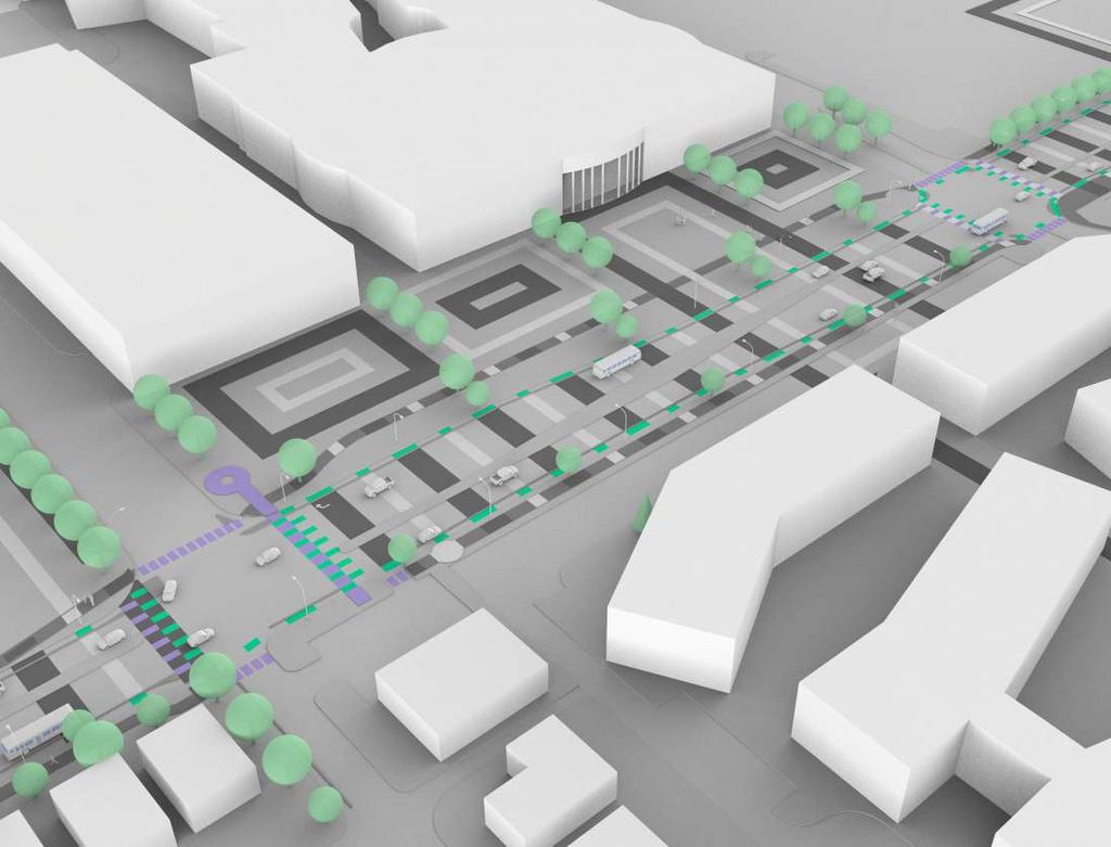
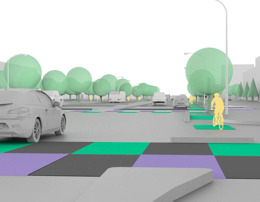
22 STRIPED GROUND: REIMAGINING THE BOULVEARD


23 Genealogy: High + Low Striped Ground: Reimagining the Boulevard is a speculative street scape project that is a work-in-progress. It combines the mosaic floors of Portugese outdoor rooms later reinterpreted at a super-scale by Roberto Burle Marx at the Copacabana beach in Rio de Janiero and the brightly colored stipe paintings of Frank Stella with the dimensional logics of the parking space and the cul-de-sac, to reimagine the boulevard in the context of wide suburban roads. The nine foot wide parking stripe provides the underlying patterning structure on the road, and stretches over the curb to define outdoor collective rooms at key spaces along its length. The cul-de-sac appears at multiple sizes: when small or medium, it is a bus stop, when large or extra-large, it is a park. Color highlights other mobilities such as bikes and pedestrians, as well as primary collective spaces. Baxia District, Libson, Portugal Copacabana Beach Promenade (Roberto Burle Marx, 1970). Harran II (Frank Stella, 1967). Hampton Roads (Frank Stella, 1961).. Suburban Mall Parking Lot Typological Cul-de-Sac


24 Skokie, Illinois Proposed for Golf Road in Skokie, Illinois, an urbanizing suburb adjacent to Chicago, Striped Ground connects the Harms Woods Nature Preserve with Niles North High School, the Old Orchard Mall, and the residential neighborhoods to the east, while catalyzing other development along its length. Working within the existing right-of-way, Striped Ground remakes the roadway for multiple mobilities by narrowing the car lanes to ten feet each (thus slowing traffic), introducing dedicated bike lanes that are physically separated from the car lanes, and substantially widening the sidewalks. Optima Old Orchard Woods Niles North Highschool Westfield Old Orchard Mall
25 Pattern Studies
26 Great-Room Studies

27 Sectional Studies A B C D A B C D
28 Mall Room Detail
29 Mall Room Detail
30

31
32

33

34 Tysons Corner, Virginia (outside of Washington, D.C.)

35


36 Golf Is A Good Walk Spoiled, Tysons Corner, Virginia. Conor Libit.

37 Golf Is A Good Walk Spoiled, Tysons Corner, Virginia. Conor Libit.

38 Golf Is A Good Walk Spoiled, Tysons Corner, Virginia. Conor Libit.
")
39 Schaumburg, Illinois (outside of Chicago)

40 The New Suburban Subdivision, Schaumburg, Illinois. Kevin Geist.

41 The New Suburban Subdivision, Schaumburg, Illinois. Kevin Geist.

42 The New Suburban Subdivision, Schaumburg, Illinois. Kevin Geist.

43 The New Suburban Subdivision, Schaumburg, Illinois. Kevin Geist.

44
12600 S Existing Conditions
 STUDY AREA BOUNDARY Study Area Boundary Study Area Context The District Riverton Meadows Vista Station Mountain View Village Market Center 2 Mile Radius 12600 S Existing Conditions 12600 S is a river of
DRAFT ROOSEVELT ROAD. District Recommendations. Figure 5.23 The Roosevelt Road Corridor
 CHAPTER 5 Figure 5.23 The Road Corridor Road will develop as a mixed-use corridor, emphasizing regional retail, west of the river and mixed-use development east of the river. KEY RECOMMENDATIONS 1. High
Access Management: An Overview
 Figures 1-5 Below Evolution of development along a highway. In the early stages, land along the road is used for farming with little traffic generated. As time passes, the highway corridor becomes a de
Chapter 4. Linking Land Use with Transportation. Chapter 4
 Chapter 4 Linking Land Use with Transportation Chapter 4 59 Chapter 4 Linking Land Use with Transportation Community Design and Transportation Program Introduction Since the 1950s, the predominant development
CHAPTER 3 VISION, GOALS, & PLANNING PRINCIPLES. City of Greensburg Comprehensive Plan. Introduction. Vision Statement. Growth Management Goals.
 CHAPTER 3 VISION, GOALS, & PLANNING PRINCIPLES Introduction The Greensburg Comprehensive Plan is intended as a working community document. A combination of long and short-term goals, this document is intended
MALL REVITALIZATION CASE STUDIES
 MALL REVITALIZATION CASE STUDIES DECEMBER 9, 2012 MALL REVITALIZATION OVERVIEW Introduction Sample Case Studies prepared for Lacey Woodland District Steering Committee as it considers strategies to revitalize
Implementation Guide Comprehensive Plan City of Allen
 Implementation Guide 2030 Comprehensive Plan City of Allen DRAFT 2015 Implementation Guide Allen 2030 Comprehensive Plan INTRODUCTION The Comprehensive Plan serves as a guide for the growth and development
Civic Center District
 Civic Center District The Civic Center district is the civic and social heart of Warrenville, containing such public buildings as the City Hall, Warrenville Public Library, Police Station, Park District
A Plan for the Heart of the Region: Tukwila, WA
 : Tukwila, WA 1 The Plan orchestrates the Restructuring of a 1,000-acre Regional Shopping Area into a Social and Symbolic for the Region. REGIONAL CONTEXT Downtown Seattle (Metropolitan ) 20 miles Bellevue
12/9/2013. HOLLYWOOD/PINES CORRIDOR PROJECT AMPO 2013 Annual Conference October 24, Our Perspective. Broward.
 HOLLYWOOD/PINES CORRIDOR PROJECT AMPO 2013 Annual Conference October 24, 2013 Our Perspective Broward Fort Lauderdale 1 Broward Metropolitan Planning Organization Fort Lauderdale Fort Lauderdale Skyline
Chapter 1 - General Design Guidelines CHAPTER 1 GENERAL DESIGN GUIDELINES
 CHAPTER 1 GENERAL DESIGN GUIDELINES 1.0 INTRODUCTION This Publication has been developed to provide current, uniform procedures and guidelines for the application and design of safe, convenient, efficient
WEST LOOP DESIGN GUIDELINES CHECKLIST
 WEST LOOP DESIGN GUIDELINES CHECKLIST Section 1.0 General Strategies 1.1 DESIGN EXCELLENCE: ENCOURAGE HIGH QUALITY AND INNOVATIVE DESIGN OF NEW BUILDINGS WITHIN THE WEST LOOP WITHOUT BEING PRESCRIPTIVE
MISSION STREETSCAPE PLAN. Neighborhood Commercial Streets handle continuous activity. Neighborhood Commercial STREET ROW: Main Design Treatments
 Neighborhood Commercial STREET ROW: 64-80 Main Design Treatments CORNER reduce crossing distance for pedestrians, create entrances to a residential area and slow cars down. help widen sidewalk allocating
Sahuarita District & Phase 1 Master Plan. Town Council December 11, 2017
 Sahuarita District & Phase 1 Master Plan Town Council December 11, 2017 Visioning Study Visioning Process Advisory Group Meetings Community Questionnaire Town Center Case Studies Community Analysis The
Gold Line Bus Rapid Transit Transit Oriented Development (BRTOD) Helmo Station Area Plan
 Helmo Station Area Plan") Appendix F Gold Line Bus Rapid Transit Transit Oriented Development (BRTOD) Helmo Station Area Plan Introduction and Purpose of the Plan The Gold Line Bus Rapid Transit facility is an eleven-mile dedicated
Appendix F Gold Line Bus Rapid Transit Transit Oriented Development (BRTOD) Helmo Station Area Plan Introduction and Purpose of the Plan The Gold Line Bus Rapid Transit facility is an eleven-mile dedicated
Courtice Main Street Study Community Vision Workshop PLANNING SERVICES DEPARTMENT
 Courtice Main Street Study Community Vision Workshop PLANNING SERVICES DEPARTMENT July 22, 2009 Tonight s Meeting 7:00 pm Introduction David Crome, Director of Planning 7:05 Presentation Stasia Bogdan,
Linking Land Use and Transportation
 Linking Land Use and Transportation NJ s Experience January 18, 2006 NYMTC - PFAC Mark Stout Planning & Development New Jersey Department of Transportation Where We Are Los Angeles, CA San Francisco, CA
THE NEIGHBORHOOD TODAY
 THE NEIGHBORHOOD TODAY CORE AREA VISION How are we Good Urbanism A Site s DNA thinking about Elements of great Unique elements urban communities embedded in a place the site and design? ELEMENTS LIKE:
TOD 101 CREATING LIVABLE COMMUNITIES WITH TRANSIT
 1 CREATING LIVABLE COMMUNITIES WITH TRANSIT What are transit Centered Communities? Benefits of Partnerships to Support and Implement What You Will Learn Portland s Pearl District Your Trainers Today Catherine
Secrest Short Cut and Monroe Expressway Small Area Plan AUGUST 29, 2018
 Secrest Short Cut and Monroe Expressway Small Area Plan AUGUST 29, 2018 Background and Process Monroe Expressway will be open by the end of 2018 Union County and Indian Trail identified a need to revisit
GOODY CLANCY WITH KITTELSON & ASSOCIATES RHODESIDE & HARWELL FARR ASSOCIATES W-ZHA
 1 1. Welcome 5 min. 2. Follow-up from 9/22 / Corridor of Light, ground floor uses 20 min. 3. Small on-site open spaces / Overview of types, identities 15 min. 4. Rosslyn Plaza Park / Rosslyn Plaza PDSP
This Review Is Divided Into Two Phases:
 Semiahmoo Town Centre Review The purpose of this review: To review the Semiahmoo Town Centre Concept Plan, originally approved in 1993, to ensure that this centre will continue to serve the needs of South
Page 2. Introduction and Overview Page 3. Path Page 4. Edge Page 5. District Page 6. Landmark. Burlington Image of the Town
 Page 2. Introduction and Overview Page 3. Path Page 4. Edge Page 5. District Page 6. Landmark Burlington Introduction Overview 2 The is an inventory of Burlington s key physical typologies. The process
ELMVALE ACRES SHOPPING CENTRE MASTER PLAN
 ELMVALE ACRES SHOPPING CENTRE MASTER PLAN Contents 1.0 INTRODUCTION... 2 2.0 LOCATION... 2 3.0 EXISTING CONTEXT... 2 4.0 VISION & GUIDING PRINCIPLES... 2 5.0 LAND USE AND BUILT FORM... 4 5.1 St. Laurent
TRANSIT ORIENTED DEVELOPMENT PINELLAS COUNTY MPO LIVABLE COMMUNITIES INITIATIVE PINELLAS COUNTY COMPREHENSIVE PLAN AMENDMENTS
 PINELLAS COUNTY MPO LIVABLE COMMUNITIES INITIATIVE MODEL LAND DEVELOPMENT CODE TRANSIT ORIENTED DEVELOPMENT PINELLAS COUNTY COMPREHENSIVE PLAN AMENDMENTS MPO Livable Communities Initiative Goal: Improve
Seneca Meadows. Block 4 Locate office, technology, and medical development adjacent to I Screen views of garage structures from I-270.
 Seneca Meadows Seneca Meadows has an industrial park in its southern end and a mixed-use employment area planned for the north end. The district benefits from extensive I-270 visibility, stream valley
b r a n c h av e n u e tr a n s it co r r i d o r r e vita lization pl a n a m o d el fo r s u b u r ban retro fit
 b r a n c h av e n u e tr a n s it co r r i d o r r e vita lization pl a n a m o d el fo r s u b u r ban retro fit P R I N C E G EO RG E S CO U NT Y, M D ADO PTED 0 p R O J E C T C AT E G O R Y : U R B
3.5 Historic Old Town Character Area
 3.5 Historic Old Town Character Area Downtown Suwanee is characterized by two areas: Historic Old Town and Town Center. Due to their proximity and similar purposes, the two areas can function together
Courthouse Square Planning & Urban Design Study. Courthouse Square Working Group #13 October 15, 2014
 Courthouse Square Planning & Urban Design Study Courthouse Square Working Group #13 October 15, 2014 1 Courthouse Square Process Working Group Community Courthouse Square Advisory Groups & Civic Associations
GPA FALL 2017 CONFERENCE
 Change in Doraville Doraville at the beginning of a new era Design Doraville (Comp. Plan) adopted in 2016 Doraville Town Center Masterplan LCI (2005) Downtown Doraville Masterplan LCI (2010) 2014 Adoption
2.1 Location and Size
 2.0 Context 7 2.1 Location and Size The Saanich Penninsula The study area is centrally located within the Town boundaries on the east side of Highway 17, which runs through Sidney in a north-south direction.
Sub Area 2: Downtown Overland Park
 Downtown 132 2.12 encompasses over 600 acres and extends between 71st Street and 87 th Street including Downtown Overland Park. The area is home to several individual historic sites and structures, including
Table of Contents. Elm Avenue Improvement Plan City of Waco, Texas. Introduction 1. Existing Context 1 Figure 1 2.
 Table of Contents Introduction 1 Existing Context 1 Figure 1 2 Plan Guidelines 3 Future Urban Form 4 The West-End 4 Main Street 6 The East-End 7 Figure 2 9 Public Improvement Recommendations 7 General
Preci nct P l ans Figure 56 Campus Aerial Photo, 2008 CAL STATE EAST BAY, HAYWARD CAMPUS MASTER PLAN
 9 Precinct Plans This section contains a detailed discussion of the planning and design concepts for specific areas or precincts of the Cal State East Bay Hayward campus. The Precinct Plans pertain to
Part 2 Common Elements
 WHITE FLINT SECTOR PLAN Round Table Discussion: Part 2 Common Elements October 8, 2007 The M-NCPPC 1 Role Regional Marketplace North Bethesda s Downtown with a Conference Center District The M-NCPPC 2
The Preferred Scenario Map, attached, shows the proposed land use pattern. Vibrant downtown Vallejo is a destination for locals and visitors alike.
 MEMORANDUM DATE November 18, 2015 TO Andrea Ouse, Community Development Director Mark Hoffheimer, Senior Planner City of Vallejo FROM Andrew Hill SUBJECT Narrative Description of the Preferred Scenario
ARLINGTON COUNTY, VIRGINIA
 ARLINGTON COUNTY, VIRGINIA County Board Agenda Item Meeting October 15, 2005 DATE: September 28, 2005 SUBJECT: Request to Advertise the adoption of the 2005 Clarendon Sector Plan C. M. RECOMMENDATION:
Equitable Growth Through TOD Planning
 Equitable Growth Through TOD Planning Community Meeting # 2 November 2017 Goals Objectives Extend investment from downtown Connect neighborhoods physically and economically Enhance places based on local
Complete Neighbourhood Guidelines Review Tool
 Complete Neighbourhood Guidelines Review Tool Prepared By: City of Regina Planning Department October 2014 Page 1 of 14 Community Development Review Checklist for Secondary Plans and Concept Plans The
ROBBINSDALE LRT STATION CDI DEVELOPMENT GUIDELINES
 August 2018 OVERVIEW The City of Robbinsdale has a prime-opportunity site in the middle of the 13 mile stretch of the Bottineau LRT corridor / Blue Line extension. Robbinsdale offers a prominent, vital,
Robbinsdale LRT Station. CDI Development Guidelines. August Overview
 Robbinsdale LRT Station August 2018 Overview The City of Robbinsdale may have the coolest opportunity site along the 13 mile stretch of the Bottineau LRT corridor / Blue Line extension. Located a block
Town Center. Block 5 Existing multifamily residential units are expected to remain.
 Area Guidelines Germantown s districts should be developed as distinct communities with unique features that are supported through the guidelines. The guidelines not only help distinguish these districts
One of the components of the sustainable, traditional neighborhood is the neighborhood center.
 One of the components of the sustainable, traditional neighborhood is the neighborhood center. The neighborhood center defines a community s identity and is the place for events, leisure activities, public
Transportation Land Use Integration & Regional Planning. Don Kostelec, AICP Senior Planner, Louis Berger Group February 1, 2010
 Transportation Land Use Integration & Regional Planning Don Kostelec, AICP Senior Planner, Louis Berger Group February 1, 2010 Transportation Land Use Integration DOT-HUD-EPA Sustainable Communities Initiative
PROTOTYPE DESIGN/INTRODUCTION
 PART III: PROTOTYPE DESIGN These concepts and guidelines described earlier were used to develop a prototype design for an emerging suburban area located west of the City of Milwaukee. This was done to
Coast Highway Oceanside, California
 Coast Highway Oceanside, California Coast Highway Plan Zones What We ve Heard - Walkable/Bikeable Community (Senior and Child Friendly) -Wider Sidewalks -Street Trees -Traffic Calming -Bike Lanes -Paseos
SECTION TWO: Urban Design Concepts
 SECTION TWO: Urban Design Concepts The Gardnerville Plan for Prosperity shapes economic opportunities presented by regional growth. The Urban Design Concepts provide policies and concepts for land use,
Discussion Questions - Summary. 1. What do you value most about the area and think needs to be preserved by the Plan?
 Community Meeting #1 Discussion Questions - Summary 1. What do you value most about the area and think needs to be preserved by the Plan? Architectural Retain character through preservation of historical
ANCHOR TO ANCHOR. Rescale the street to create an iconic boulevard.
 ANCHOR TO ANCHOR Rescale the street to create an iconic boulevard. UR NE ER UV GO NE LA OBJECTIVES 1. Maintain appropriate traffic flow and prioritize commercial curb access 2. Mark gateways at the street
The Neighbourhood Unit
 DESIGN... Site Framework PROCESS IMPLEMENTATION 22 TOOL DESCRIPTION The neighbourhood unit is a holistic planning and design strategy that addresses the configuration of the major physical components of
MIXED-USE VILLAGE OVERLAY FLOATING DISTRICT
 MIXED-USE VILLAGE OVERLAY FLOATING DISTRICT Zoning regulations developed by committee to the Planning Board for the Town of DeWitt, NY Issue date: 13 July 2017 revised 3/12/2018, revised 4/26/2018, 5/9/2018
Neighborhood Districts
 NEIGHBORHOOD DISTRICTS SEVEN MAIN DISTRICTS Neighborhood Districts While the Development Plan provides a broad-scale overview of the neighborhood, this section focuses on uses and relationships at the
City of Farmington. Downtown Plan. Amendment to the 1998 Master Plan Adopted October 11, 2004
 City of Farmington Amendment to the 1998 Master Plan Adopted October 11, 2004 Introduction Planning Background 1 Scope and Components of the Plan Amendment 2 Concept Introduction 3 Plan Concepts 3 Conceptual
SOUTH FLORIDA TOD GRANT UPDATE
 Palm Beach Transportation Planning Agency October 2018 SOUTH FLORIDA TOD GRANT UPDATE Presented by Treasure Coast Regional Planning Council in partnership with SFRTA & SFRPC What is Transit Oriented Development
2. Form and Character. 2.1 Introduction. 2.2 The Downtown Addition Plan. 2.1 Introduction
 2.1 Introduction 2.1 Introduction This section of the Specific Plan describes and illustrates the desired form, character and uses of the Downtown Addition and explains the underlying design principles.
DELIVERING ON THE TRANSIT PROMISE
 DELIVERING ON THE TRANSIT PROMISE Dena Belzer October 6, 2015 Presentation Overview 1. Puget Sound As a Transit Region: Putting SeaTac in Context 2. Starting at the Beginning: How Does TOD Work? 3. Strategies
[PLANNING RATIONALE] For Site Plan Control and Lifting of Holding Zone By-Law 101 Champagne Avenue. May 23, 2014
![[PLANNING RATIONALE] For Site Plan Control and Lifting of Holding Zone By-Law 101 Champagne Avenue. May 23, 2014](/thumbs/75/71599615.jpg "[PLANNING RATIONALE] For Site Plan Control and Lifting of Holding Zone By-Law 101 Champagne Avenue. May 23, 2014") [PLANNING RATIONALE] For Site Plan Control and Lifting of Holding Zone By-Law 101 Champagne Avenue May 23, 2014 Contents 1.0 Introduction... 2 2.0 Site Context... 2 2.1 Adjacent Uses... 2 Figure 1: Site
[PLANNING RATIONALE] For Site Plan Control and Lifting of Holding Zone By-Law 101 Champagne Avenue May 23, 2014 Contents 1.0 Introduction... 2 2.0 Site Context... 2 2.1 Adjacent Uses... 2 Figure 1: Site
Comprehensive Plan. Village of Downers Grove. Adopted October 4, 2011 Updated 2015 Updated 2017 LAKE MICHIGAN
 Village of Downers Grove Comprehensive Plan 294 Barrington Hills LAKE MICHIGAN Arlington Heights 94 90 Elgin Schaumburg 53 47 90 294 20 355 KANE 290 Elmhurst Downers Grove LaGrange 88 Aurora Naperville
TOD IMPLEMENTATION BEST PRACTICE TOOLBOX Leveraging Transit for City Shaping
 arrington.gb@gmail.com gbplacemaking.com THE TOD I LIVE IN ~ PORTLAND, OR TOD IMPLEMENTATION BEST PRACTICE TOOLBOX Leveraging Transit for City Shaping BEST PRACTICE TOPICS Timing & transit Parking & retail
Subarea 5 Southern Gateway. Vision. Mobility The proposed street network will create developable blocks that are scaled appropriately for the area.
 southern gateway 194 Southern Gateway extends south of I-435 to 123 rd Street and includes the area past the Blue Valley Parkway division. This area is adjacent to major office centers such as the College
YONGE STEELES CORRIDOR SECONDARY PLAN. Young + Wright / IBI Group Architects Dillon Consulting Ltd. GHK International (Canada) Ltd.
 Ltd.") PART A: PREAMBLE 1.0 PURPOSE The purpose of this Secondary Plan is to provide a development framework for intensification of the Yonge/ Steeles corridor including the north side of Steeles Avenue West
PART A: PREAMBLE 1.0 PURPOSE The purpose of this Secondary Plan is to provide a development framework for intensification of the Yonge/ Steeles corridor including the north side of Steeles Avenue West
Chapter 6: Community Character
 Chapter 6: Community Character The term "community character" covers a broad spectrum of concerns. First and foremost, community character is a visual concept. In Long Grove, however, community character
Presentation August 6, 2018
 Steering Committee Meeting #4 Presentation August 6, 2018 1 A. Commercial Strip Development and Alternatives B. Public Kick-off Meeting C. Next Steering Committee Meeting Road Map of Planning Process 2
Overview of the Plan. The Building Blocks of Centers, Neighborhoods and Network INTERNAL DRAFT
 Overview of the Plan 4 East Davidson Ramah Church Rd June Washam Rd Bradford District Park Bradford Shearer Rd Campus District NC 73 Davidson-Concord North Rocky River This Master Plan projects an approximate
Strategic Growth Area #1 Northampton Boulevard Corridor Area
 Strategic Growth Area #1 Northampton Boulevard Corridor Area Description Strategic Growth Area #1 has established itself as a major employment center in Southside Hampton Roads. Opportunities exist to
Michigan City Alternative Analysis Realignment Study. Progress Status Update Report Presentation to City Council February 1, 2012
 Michigan City Alternative Analysis Realignment Study Progress Status Update Report Presentation to City Council Project Web Site Project Web Site is Active www. emichigancity.com Click on NICTD logo at
TRANSIT ORIENTED DEVELOPMENT STRATEGIC PLAN t 2014 EXECUTIVE SUMMARY
 TRANSIT ORIENTED DEVELOPMENT STRATEGIC PLAN t 2014 SETTING THE STAGE Development around rail stations is part of Denver striving to become a world-class city where everyone can be part of the community.
1.0 VISION STATEMENT. December 6, PRINCIPLES
 Vision Statement Lincoln Regional Airport 1.0 VISION STATEMENT 1.1 City LOCATION of AND OVERVIEW The Easton Lincoln Place Land Use Master Plan identifies the principles, goals, policies, and standards
Making Transit Oriented Development Work For Boonton, NJ
 Making Transit Oriented Development Work For Boonton, NJ Bloustein School of Planning and Public Policy Studio Dan Burton Loannie Dao Webster Slater Brandon Williams Ian Watson Maria Laham Nicola Mammes
MENDING A RIFT: Urbanism for North Tulsa, Oklahoma UNIVERSITY OF NOTRE DAME SCHOOL OF ARCHITECTURE 2017 GRADUATE URBAN DESIGN STUDIO
 MENDING A RIFT: Urbanism for North Tulsa, Oklahoma UNIVERSITY OF NOTRE DAME SCHOOL OF ARCHITECTURE 2017 GRADUATE URBAN DESIGN STUDIO Project Description Mending A Rift: Urbanism for North Tulsa focuses
Urban Design & Placemaking
 Urban Design & Placemaking What is Urban Design? Urban Design is the discipline of creating equitable, vibrant, and sustainable places with distinct identities. The profession pulls from other built environment
General Manager, Planning and Development; General Manager, Parks, Recreation and Culture. Proposed Mini-Park and Plaza Designations
 Corporate NO: R106 Report COUNCIL DATE: June 16, 2008 REGULAR COUNCIL TO: Mayor & Council DATE: June 12, 2008 FROM: SUBJECT: General Manager, Planning and Development; General Manager, Parks, Recreation
A Healthy Future Walkability Through Community Design. Fit Families North Carolina October 18, 2004
 A Healthy Future Walkability Through Community Design Fit Families North Carolina October 18, 2004 Joe Morris, AICP Planning & CD Manager jmorr@salisburync.gov 704-638-5324 Dan Mikkelson, PE Land Management
Plano Tomorrow Vision and Policies
 Plano Tomorrow Vision and Policies PLANO TOMORROW PILLARS The Built Environment The Social Environment The Natural Environment The Economic Environment Land Use and Urban Design Transportation Housing
S C O P E O F W O R K A P R I L
 white flint 2 sector plan S C O P E O F W O R K A P R I L 2 0 1 2 MONTGOMERY COUNTY PLANNING DEPARTMENT M-NCPPC MontgomeryPlanning.org 1 white flint 2 sector plan Scope of Work abstract This scope of work
Transportation. Strategies for Action
 Transportation A major priority for the Overlake Neighborhood is to develop a multimodal transportation system. To achieve this system, a balance has to be found among travel, circulation and access needs;
On behalf of Metrolinx, in coordination with the City of Mississauga. and Presentation Materials (draft)
") On behalf of Metrolinx, in coordination with the City of Mississauga Port Credit GO Station Area Master Plan Study Advisory Panel Meeting #3 Handouts and Presentation Materials (draft) June 10, 2015 Agenda
On behalf of Metrolinx, in coordination with the City of Mississauga Port Credit GO Station Area Master Plan Study Advisory Panel Meeting #3 Handouts and Presentation Materials (draft) June 10, 2015 Agenda
4 C OMMUNITY D ISTRICTS
 4 C OMMUNITY D ISTRICTS N ew development in the Area will include many different types of land uses, including a destination retail area that attracts people from all over the region; recreation opportunities
Lehigh Acres Land Development Regulations Community Planning Project
 Lehigh Acres Land Development Regulations Planning Effort Summary In July, 2010 Commissioner Frank Mann invited the Lehigh Acres community to start discussing how to achieve their recently adopted community
Northwest commuter rail station US 36 BRT. Westminster Station
 Northwest commuter rail station Westminster Station US 36 BRT Westminster Center US 36 & Church Ranch Broomfield Flatiron/96 th St. US 36 & McCaslin Table Mesa Boulder Junction 13-month effort that will
IMPLEMENTATION STRATEGIES. In This Chapter. Goals & Strategies 182 Project List 183 Future Land Use 186 CHAPTER 11 IMPLEMENTATION STRATEGIES
 In This Chapter Goals & Strategies 182 Project List 183 Future Land Use 186 11 IMPLEMENTATION STRATEGIES NORTH AUGUSTA, SC 2017 COMPREHENSIVE PLAN 179 Individual commitment to a group effort that is what
Goals and Objectives. Garfield Blvd. Washngton Park
 N 3 Neighborhood, Node, and Network Red Line Metra State St Green Line Garfield Blvd Washngton Park Land Use Plan Mixed use Commercial Institutional Open space Goals and Objectives I. Neighborhood: Enhance
MEETING PURPOSE AND OVERVIEW
 MEETING PURPOSE AND OVERVIEW On February 23, 2012, the City of Elk Grove hosted the first of two community workshops related to the Southeast Policy Area. The workshop was held from 6:00 8:30 p.m. in the
Packet Contents. Joint Planning Work Session Timeline.. Introduction.. Work Session Directions... 5
 City Council and Planning & Zoning Commission Joint Planning Work Session Packet June 30, 2014 1 2 Packet Contents Joint Planning Work Session Timeline.. Introduction.. 4 4 Work Session Directions... 5
4.1.3 LAND USE CATEGORIES
 4.1.3 LAND USE CATEGORIES a. City Center District The City Center District incorporates the existing character and mix of uses in downtown Belmont to encourage redevelopment and new development in keeping
03 HIGH PRIORITY SITES
 03 HIGH PRIORITY SITES HOWARD PARK Howard Park is one of South Bend s largest riverfront parks, hosting nearly acres. Howard Park has a very passive landscape with a recreation building, ice skating rink,
Outer Congress Street Land Use
 Outer Congress Street Land Use Outer Congress Street, with its historic residential district, natural resource and open space amenities, trail network, and proximity to major transportation infrastructure
Lambeth Main Street Streetscape Improvements
 Lambeth Main Street Streetscape Improvements Open House October 5th, 2017 Agenda 1. Introduction 2. Project Background 3. Context 4. Project Objectives 5. Design Principles & Approach 6. Streetscape Design
Pattern 3: Parking. Parking in great amounts is not a characteristic of great streets. Allan Jacobs. Community Form and Mobility Principles
 Pattern 3: Parking Parking in great amounts is not a characteristic of great streets. Allan Jacobs Parking is an integral part of the municipal circulation system and is often as important as roads in
SECTION UNIFIED DEVELOPMENT ORDINANCE SECTION Part 1 Ordinance. ARTICLE 1 Zoning Districts
 SECTION 1-100 UNIFIED DEVELOPMENT ORDINANCE SECTION 1-300 Part 1 Ordinance SECTION 1-100. Introduction. ARTICLE 1 Zoning Districts Crystal Lake strives to maintain a balance of various land uses for a
The GATEWAYS Sub Area Master Plan. City of Walker
 The GATEWAYS Sub Area Master Plan City of Walker Introduction: The Walker City Commission and Planning Commission decided in 2011 to create a sub-area master plan for the Remembrance Road and Wilson Avenue
DOWNTOWN JACKSONVILLE MASTER PLAN S T R E E T H I E R A R C H Y
 DOWNTOWN JACKSONVILLE MASTER PLAN S T R E E T H I E R A R C H Y Gateway Intra-District Business Inter-District 44 CELEBRATING THE RIVER: A PLAN FOR DOWNTOWN JACKSONVILLE The Transportation Network This
New York Avenue Streetscape and Trail Project Public Meeting #1 Summary
 New York Avenue Streetscape and Trail Project Public Meeting #1 Summary I. King Jordan Student Academic Center (SAC) Gallaudet University, Washington, DC February 23, 2017 Table of Contents 1.0 Introduction...
WILMINGTON WATERFRONT Approved Project
 LA Waterfront WILMINGTON WATERFRONT Approved Project pp j Approved Project Annual Program Update February 28, 2011 AGENDA Welcome Update on the LA Waterfront Program Projects Underway Upcoming Projects
DRAFT. October Wheaton. Design Guidelines
 October 2011 DRAFT Wheaton Design Guidelines 2 Draft - Design Guidelines - Wheaton Sector Plan Contents 04 Section 1: Introduction 06 Section 2: Context 08 Section 3: Design Guidelines 09 Goal 1: Create
Appendix 4 Park, Trail, and Recreation Facilities For more information, call the Park Planning and Stewardship Division at
 Appendix 4 Park, Trail, and Recreation Facilities For more information, call the Park Planning and Stewardship Division at 301-650-4380 montgomery county planning board maryland-national capital park and
York Road Arial View
 Arial View Bridge Ave YORK ROAD THE SITE TODAY View west down View west from View east The 1.5 ha site is located south of the and to the east of Queen Street. The site includes an existing car park, disused
UNIVERSITY OF MICHIGAN:
 Chapter Eight UNIVERSITY OF MICHIGAN: North Campus I. Introduction The University of Michigan currently owns approximately 800 acres of land in the northeast section of Ann Arbor. North Campus refers to
St. Kevin s Area Planning Collaborative
 Table of Contents page 2 EXECUTIVE SUMMARY 3 MISSION STATEMENT 4 NEIGHBORHOOD CONTEXT 6 STREET CHARACTER 7 SITE PARAMETERS 9 COMMUNITY CHARRETTE - VISIONING GROUP TABLE 1 11 GROUP TABLE 2 12 GROUP TABLE
The Illinois Department of Transportation and Lake County Division of Transportation. Route 173, including the Millburn Bypass
 The Illinois Department of Transportation and Lake County Division of Transportation welcome you to this Public Hearing for U.S. Route 45 from Illinois Route 132 to Illinois Route 173, including the Millburn