Nanuet Transit Oriented Development GEIS Scoping Workshop
|
|
|
- Alexandrina Horn
- 5 years ago
- Views:
Transcription


1 Nanuet Transit Oriented Development GEIS Scoping Workshop presented to Hamlet of Nanuet presented by Cambridge Systematics, Inc. AKRF Clarkstown Planning Department February 1 26, 2018
2 Agenda Welcome & Introductions Background Project Overview - Hamlet of Nanuet TOD Plan TOD Plan Recommendations State Environmental Quality Review (SEQR) Draft Scoping Document 2


3 Project Team 3
4 4 Background
5 Evolutionary Planning Process Town of Clarkstown Comprehensive Plan (2009) Commercial Corridor Transportation & Land Use Study ( ) Cleaner Greener Communities Grant: Hamlet of Nanuet TOD Study ( ) 5


6 Comprehensive Plan 6


7 Commercial Corridor Transportation & Land Use Study 7

8 Commercial Corridor Transportation & Land Use Study 8


9 Commercial Corridor Transportation & Land Use Study 9


10 Cleaner, Greener Communities Grant: Hamlet of Nanuet TOD Study Grant program offered by NYSERDA that supports sustainable development and smart growth practices within communities throughout NY Town of Clarkstown received a $150,000 grant to study and develop a transit-oriented development (TOD) plan for the Hamlet of Nanuet TOD encourages:» Compact, mixed-use development near public transit facilities» Creates sustainable communities where people of all ages and incomes can access transportation and housing choices within walking distance of a transit services TOD 10
11 11 Hamlet of Nanuet TOD Plan Project Overview
12 Project Intent & Goal The intent of the Transit Oriented Development (TOD) Plan was to support the development of a transit-oriented neighborhood centered around the transit station and mixed-use infill development that will link the historic downtown commercial district and the regional outdoor shopping center. The goal was to create a plan that supports a walkable neighborhood that will provide new workforce housing, encourage public transit use, create jobs, and strengthen the local economy. 12


13 Project Team Steering Committee 13


14 Steering Committee George Hoehmann, Town Supervisor Lino Sciarretta, Town Attorney James Flynn, Civic Association Roberta Bangs, Civic Association Risa Hoag, Chamber of Commerce Susan Farese, Chamber of Commerce Anthony Pallogudis, Chamber of Commerce Ryan Hidalgo, Simon Properties Mark McNeill, Superintendent of the Nanuet Union Free School District Thomas Weiner, NYSDOT Todd Westhuis, NYSDOT Robyn Hollander, MTA Metro- North Railroad Barbara Wallenstein, Nanuet EMS Jeff Hutt, Postmaster, Nanuet Post Office Helen Kenny-Burrows, Rockland County Planning Vincent Carella, Principal, Nanuet Senior High School 14
15 Nanuet TOD Project Approach Existing Conditions Physical Opportunities & Constraints Property & Business Owner Feedback Public Workshop #1 (November 2016) TOD Plan Alternatives Initial TOD Concept Development Neighborhood Development Goals & Principles Future Land Use & Market Assessment Public Workshop #2 (April 2017) Draft TOD Plan Public Workshop #3 (June 2017) Final TOD Plan (September 2017) 15


16 Public Workshop #1 November 16, 2016 at Nanuet High School Cafeteria Objectives:» Initiate Project» Review Existing Conditions» Introduce TOD» Gather Community Ideas and Opinions 16

17 Public Workshop #2 Saturday April 1 st at 10:00 AM & Monday April 3 rd at 7:00 PM at the Nanuet High School Auditorium Objectives:» Present TOD Concept» Review Potential Strategies» Gather Community Feedback» Ideas and Opinions 17

18 Public Workshop #3 June 4, 2017 at Greater Nanuet Chamber of Commerce Annual Street Fair Objectives:» Present Draft TOD Plan» Gather Community Feedback 18
19 Property & Business Owner Feedback Occurred between August and October, 2016 Conduced as one-on-one in-person meetings or by telephone conference call when requested by interviewee Interviewed 13 different private land-owners and business owners; 3 public entities The purpose of the interviews was threefold:» Inform area landowners and business owners about the project;» Get the support of the business community for the TOD project;» Get new ideas and perspectives for the project No stated objection to proposed visions for the TOD project 19
20 Additional Meetings Civic Association Chamber of Commerce School Board 20
21 21 TOD Plan Recommendations


22 Existing Land Use Mixture of industrial, commercial, and downtown land uses Light-Industrial / Office predominant land use around train station 22
")
23 Existing Zoning LIO Light Industrial Office around the train station MF-1 Multi-family is currently allowed as-of-right, however most is owned by County and used for commuter parking RS Regional Shopping along the northern boarder, adjacent to The Shops at Nanuet HC recently re-zoned Hamlet Center along Main Street (previously commercial shopping) 23
24 Proposed Nanuet TOD Concept Three clearly defined zoning districts Each district is supportive of one-another, but maintains unique qualities Aligns land-uses with those traditionally around commuter rail stations and downtowns today TOD 1 TOD 2 TOD 3 HC Staged-approach that can be implemented over time as market forces dictate 24
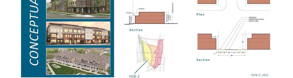
25 Prospect Street TOD Area 1 New transit-oriented development zoning district» Light industrial office (LIO) to TOD Two-three story walk-up residential» Townhomes, condominiums, or one-totwo bedroom apartments» 1,000 to 1,250 square feet residential units TOD 1 25

26 TOD 1 26

27 Prospect Street TOD Area 1 Source: Plan 4 - Townhome Morgan Hill, CA

28 Prospect Street TOD Area 1 28 Source: Coventry Park Townhomes, Morris Plains, NJ

29 Prospect Street TOD Area 1 Source: Townhomes in Denville, NJ., Cambridge Systematics 29


30 Prospect Street TOD Area 1 Source: Normandy Village, Nanuet, NY; Town of Clarkstown 30
31 Prospect Street TOD Area 2 New transit-oriented development zoning district» Light industrial office (LIO) and multifamily (MF-1) to TOD Low intensity mixed-use development» 1 st floor retail / commercial / residential» 2 nd & 3 rd floors residential Limited commercial uses» Ratio of residential to commercial square feet, respectively» Commercial uses would be aimed at serving residents TOD 2 31

32 TOD 2 32

33 Prospect Street TOD Area 2 33 Source: Chancellor's Row Townhomes in Washington, D.C., Steve Kale

34 Prospect Street TOD Area 2 Source: Swansea MetroLink Station - Senior Apartments, Southwestern Illinois Development Authority (SWIDA) 34
35 Prospect Street TOD Area 2 35 Source: Park Ridge, NJ, Cambridge Systematics
36 Prospect Street TOD Area 2 Source: Station Place, Park Ridge, NJ, Cambridge Systematics 36


37 Prospect Street TOD 2 37
38 Existing Conditions Westbound on Prospect Street 38


39 Conceptual TOD 2 Zoning 3 Story Building with 3 rd Floor Setback (30 ) 39


40 Rendered Perspective Westbound on Prospect Street 40
41 Orchard Street TOD Area 3 New transit-oriented development zoning district» LIO, RS, and HC to TOD 3 Medium intensity mixed-use development» 1 st floor retail / commercial 2 nd,3 rd, and 4th floors residential Greater commercial presence» Ratio of residential to commercial square feet, respectively» Commercial uses would be aimed at serving residents Three-to-four stories story residential» Studio, one bedroom, and two bedroom apartments» 750 sq. ft. to 1,000 square feet residential units TOD 3 41

42 TOD 3 42

43 Orchard Street TOD Area 3 Source: 233 East King Street, Malvern, PA; GoogleMaps 43


44 Orchard Street TOD 3 Source: Bella Vita, Senior 1 & 2 Bedroom Mixed-Use, Carson, CA; Solari Enterprises, Inc. 44

45 Orchard Street TOD 3 Source: Apartment Bldg. Roosevelt Neighborhood, North Seattle 45

46 Orchard Street TOD 3 Source: The Shops and Lofts at 47, Chicago, IL 46


47 Existing Conditions TOD 3 47

48 Conceptual TOD 3 Zoning 4 Story Building with 4 th Floor Setback (40 ) 48


49 Rendered Perspective Orchard Street & Prospect Street 49

50 Main Street Hamlet Center (HC) Maintain existing Hamlet Center zoning» Mixed-use residential over commercial» 2-3 story downtown buildings Tweak elements of the code focused on building design elements, aesthetics, etc. to improve consistency Encourage redevelopment with reduced building setbacks Street-scape / beautification enhancements HC HC 50

51 Hamlet Commercial (HC) 51


52 Main Street Hamlet Center (HC) 52
53 53 Implementation & Infrastructure Enhancements
54 Nanuet TOD Concept Staged, tiered approach» Build off of one-another» Can be implemented over time as market forces dictate Short Term» Initiate development that is primed for immediate advancement» Limited impact» No land acquisition Long Term» Greater transit oriented development» Would require land acquisition and moderate engineering design/build» Focuses on enhanced accessibility and quality of life for hamlet 54
55 Short Term Improved signage for parking off Main Street MTA parking lot agreement for business owner / employee use Improve sidewalk infrastructure along Prospect St. & Orchard St. (would coincide with proposed TOD development) Streetscape improvements (community beautification bank) 55


56 Short Term Infrastructure Enhancements Sidewalks 56


57 Long Term Creation of a street grid Parallel roadways to Main St. Improved bike and pedestrian accessibility New relocated commuter parking lot Community green space Metered parking along Main St. Additional parking spaces along new roads Public-Private-Partnerships parking 57


58 Long Term Infrastructure Enhancements Multi-Use Path or Roadway Community Green Space / Park 58
59 59 State Environmental Quality Review Act (SEQRA)
60 SEQRA New York State statute Provides a stepped process in order to determine whether or not a proposed governmental action will or will not have an impact on the environment Designed to identifying potential impacts of a proposed action(s) and adequately address impacts through a series of mitigation measures SEQR establishes a process to systematically consider environmental factors early in the planning stages of actions that are directly undertaken, funded or approved by local, regional and state agencies. By incorporating environmental review early in the planning stages, projects can be modified as needed to avoid adverse impacts on the environment. - SEQRA Handbook, 2010 edition. N.Y.S. Department of Environmental Conservation Meaningful public participation through meeting(s), hearing(s), and an open review of SEQRA documentation is required 60
61 Generic Environmental Impact Statement (GEIS): 6 CRR-NY Type of Environmental Impact Statement May be used when examining an entire program or plan having wide application or restricting the range of future alternative policies or projects, including new or significant changes to existing land use plans, development plans, zoning regulations or agency comprehensive resource management plans Broader, and more general than site or project specific EISs and should discuss the logic and rationale for the choices advanced. Generic EISs and their findings should set forth specific conditions or criteria under which future actions will be undertaken or approved 61
62 SEQRA Process SEQRA Milestone Determination of Significance What is this? Board Actions Timeline Town Board needs to determine whether the TOD proposal has the potential for an adverse impact Issue a positive declaration January 30, 2018 Draft Scoping Document Written document which proposes what will be studied, including the topics and analyses of potential environmental impacts Accept draft Scoping Document Establish a public meeting date and a time-period January 30, 2018 Scoping Session A period of time and public engagement activities that provides the public a meaningful way to provide comment on the draft Scoping Document. The purpose of scoping is to narrow issues and ensure that the draft EIS will be a concise, accurate and complete document that is adequate for public review Participate in public meeting Gather public comments March 2, 2018 Final Scoping Document Written document which identifies the topics and analyses of potential environmental impacts of the proposed action that will be addressed in a draft environmental impact statement Adopt the final scoping document March
63 SEQRA Process (continued) SEQRA Milestone What is this? Board Actions Timeline Draft Generic Environmental Impact Statement (DGEIS) Analysis is conducted on identified topics and potential impacts through scoping and mitigation measure are addressed Accept DGEIS as complete Establish a public hearing date and a period for public comment on DGEIS April/May 2018 Public Comment on DGEIS A period of time and public engagement activities that provide the public a meaningful way to provide comment on DGEIS Participate in public hearing June 2018 Final Generic Environmental Impact Statement (GEIS) Final environmental impacts and mitigation measures are stated and public comments are addressed Adopt Final GEIS Summer/Fall 2018 Findings Statement Summary document explaining what the impacts of the proposed action area and mitigation measures that should be taken to address impacts Adopt the Findings Statement Adopt local law Fall
64 64 Draft Scoping Document
65 DEIS Contents DEIS will identify the existing environmental conditions, potential impacts of the action, and proposed mitigation measures as appropriate for each of the major issues identified in this Scoping Document 65


66 Community Services Police, Fire, and Emergency Services Schools Solid Waste 66


67 Infrastructure Flooding/Drainage Water/Wastewater 67


68 Traffic and Parking Traffic Parking 68

")
69 Community Character Existing Conditions (Building Scale and Character) Potential Impacts (Building Scale and Character) 69
70 Other Impacts Growth Inducing Impacts Unavoidable Adverse Impacts Irreversible and Irretrievable Commitment of Resources Impacts on the Use and Conservation of Energy 70
71 71 Next Steps
72 Next Steps Gather public comment and conclude Scoping March 2, 2018 Draft Zoning Adopted Final Scoping Document Develop Draft Generic Environmental Impact Statement (DGEIS) Conduct Public Hearing on DGEIS June
73 For more information or to provide public comment Website: Phone:
74 Thank You Joe Simoes Town Planner Town of Clarkstown Phone: Christopher Titze, AICP/PP Senior Associate Cambridge Systematics Phone:
REVIEW AND EVALUATION OF REGIONAL LAND USE
 REVIEW AND EVALUATION OF REGIONAL LAND USE AND TRANSPORTATION SCENARIOS #220831 Environmental Justice Task Force October 7, 2014 VISION 2050 Process Development of Guiding Vision for Land Use and Transportation
Chapter 1.0 Introduction
 Chapter 1.0 Introduction 1.1 Background The North Metro commuter rail line is part of the RTD FasTracks regional transit system expansion program to build more than 100 miles of rail transit throughout
Town Center (part of the Comprehensive Plan)
") Town Center (part of the Comprehensive Plan) Mercer Island Town Center Looking North (2014) In 1994, a year-long process culminated in a set of design guidelines and code requirements for the Town Center
Town Center (part of the Comprehensive Plan) Mercer Island Town Center Looking North (2014) In 1994, a year-long process culminated in a set of design guidelines and code requirements for the Town Center
PINE CURVE REZONING. Property does not meet criteria for open space preservation and is not a candidate for a park
 PINE CURVE REZONING BACKGROUND Purchased as two parcels in 2001 and 2002 Annexed and Zoned Greater Downtown District Historic Center September 25, 2002 and October 7, 2002 WHAT THE PROJECT IS AND IS NOT
New Partners for Smart Growth Conference February 5, 2010
 Dan Stroh, Planning Director City of Bellevue Planning and Community Development Bellevue, WA New Partners for Smart Growth Conference February 5, 2010 Summary of Project Long-range plan update for Bel-Red
Slot Home Task Force Meeting #5 Phase 2 June 8, 2017
 Slot Home Task Force Meeting #5 Phase 2 June 8, 2017 MEETING OBJECTIVES Review Staff Recommended Strategy for Mixed Use and Main Street districts Confirm the Strategy for the Mixed Use and Main Street
PLAN ELEMENTS WORKSHOP. April 5, 2016
 PLAN ELEMENTS WORKSHOP April 5, 2016 needs more housing. But there is no one-size fits-all solution. Every neighborhood has its own character. In some places, density is not only appropriate it is badly
NORTH LAKE SPECIFIC PLAN AREA
 NORTH LAKE SPECIFIC PLAN AREA June 21, 2018 WELCOME Workshop Agenda Introduction Provide information about the program and introduce the team Background Information Share information about the North Lake
Future Proposed Development
 Future Proposed Development on and around Link light rail s Capitol Hill Station Meeting September 24, 2012 Tonight s Agenda 6:00 pm Open House 6:30 pm Introductions Richard Conlin, City of Seattle Councilmember/Sound
Atlanta BeltLine Subarea 3 Master Plan Update
 Atlanta BeltLine Subarea 3 Master Plan Update April 14, 2018 Workshop Meeting 1 22 miles, connecting 45 neighborhoods 22 MILES of transit 46 MILES of streetscapes and complete streets 33 MILES of urban
TOWN OF NEW CASTLE - Master Plan Update
 Our Presentation Today (1) Recap the Master Planning Process To Date (2) Present the Outline of the Master Planning Work Plan (3) Present the Calendar for the Master Plan (4) Outline the scope of a Downtown
Review of Opportunity Area C Draft Comprehensive Plan and Draft BOS Follow-On Motions. Special Working Group Meeting March 4, 2015
 Review of Opportunity Area C Draft Comprehensive Plan and Draft BOS Follow-On Motions Special Working Group Meeting March 4, 2015 The slides that follow identify where the draft Comprehensive Plan has
City of Tacoma Planning and Development Services
 Agenda Item E-1 City of Tacoma Planning and Development Services To: Planning Commission From: Elliott Barnett, Planning Services Division Subject: Tacoma Mall Regional Center Subarea Plan and EIS Meeting
TO: Denver Planning Board FROM: Analiese Hock, Senior City Planner DATE: March 13, 2018 RE:
 Community Planning and Development Planning Services 201 W. Colfax Ave., Dept. 205 Denver, CO 80202 p: 720.865.2915 f: 720.865.3052 www.denvergov.org/cpd TO: Denver Planning Board FROM: Analiese Hock,
Staff Report to the North Ogden City Planning Commission
 Staff Report to the North Ogden City Planning Commission SYNOPSIS / APPLICATION INFORMATION Application Request: Concept review on a legislative application to rezone land located at approximately 1750
Sheridan Boulevard S TAT I O N A R E A P L A N S H E R I D A N B O U L E VA R D S TAT I O N A R E A P L A N
 Sheridan Boulevard S TAT I O N A R E A P L A N 1 City of Lakewood Adopted November, 2006 S H E R I D A N B O U L E VA R D S TAT I O N A R E A P L A N The Vision The City of Lakewood s overall vision is
PRESENTATION TO THE CITY COUNCIL, CITY OF GLEN COVE
 PRESENTATION TO THE CITY COUNCIL, CITY OF GLEN COVE Step III BOA Implementation Strategy for the Orchard Neighborhood and Sea Cliff Avenue Corridor November 13, 2018 This presentation and the materials
PINE CURVE REZONING. BACKGROUND Purchased as two parcels in 2001 and 2002
 BACKGROUND Purchased as two parcels in 2001 and 2002 WHAT THE PROJECT IS AND IS NOT A Rezoning establishes the land use standards for Annexed and Zoned Greater Downtown District Historic Center September
SAN RAFAEL GENERAL PLAN 2040 INTRODUCTION AND OVERVIEW
 SAN RAFAEL GENERAL PLAN 2040 INTRODUCTION AND OVERVIEW Steering Committee Presentation February 14, 2018 Purpose of General Plan Guide land use and development decisions Coordinate transportation, infrastructure,
1.0 Purpose of a Secondary Plan for the Masonville Transit Village
 Report to Planning and Environment Committee To: Chair and Members Planning & Environment Committee From: John M. Fleming Managing Director, Planning and City Planner Subject: Masonville Transit Village
Final Generic Environmental Impact Statement for Adoption of the Town of New Hartford Comprehensive Plan Update
 for Adoption of the Town of New Hartford Comprehensive Plan Update Name of Action: Adoption of the Town of New Hartford Comprehensive Plan Update by the Town of New Hartford Town Board Location: Lead Agency:
Introduction and Overview
 Introduction and Overview Articulate local values and priorities Guide land use and development decisions Coordinate transportation, infrastructure, and City services with expected growth and available
Urban Planning and Land Use
 Urban Planning and Land Use 701 North 7 th Street, Room 423 Phone: (913) 573-5750 Kansas City, Kansas 66101 Fax: (913) 573-5796 Email: planninginfo@wycokck.org www.wycokck.org/planning To: From: City Planning
S A C R A M E N T O C O U N T Y JACKSON HIGHWAY & GRANT LINE EAST VISIONING STUDY
 JACKSON HIGHWAY & GRANT LINE EAST S A C R A M E N T O C O U N T Y P L A N N I N G D E P A R T M E N T SUMMARY AND WORKBOOK November 19, 2008 History of the Visioning Study Sacramento County has two growth
Downtown Streetscape Manual & Built Form Standards
 City of Guelph Downtown Streetscape Manual & Built Form Standards July 2014 Prepared by Brook McIlroy Inc. in association with Unterman McPhail Associates and McCormick Rankin Inc. City of Guelph Downtown
D-O LRT Zoning Discussion. Chapel Hill Boards & Commissions October 16, 2017
 D-O LRT Zoning Discussion Chapel Hill Boards & Commissions October 16, 2017 Update on Overall D-O LRT Station Area Initiative Objectives Design and educate on principles of Good Transit-Oriented Development
North Fair Oaks Community Plan Summary and Information
 North Fair Oaks Community Plan Summary and Information WHAT IS THE NORTH FAIR OAKS COMMUNITY PLAN? The North Fair Oaks Community Plan is part of the San Mateo County General Plan, and establishes policies
Kenilworth Landscape Design Community Workshop. June 13, 2015
 Kenilworth Landscape Design Community Workshop June 13, 2015 1 Meeting Agenda 8:30 9:00 am: Project presentation 9:00 11:00 am: Small group / table activities 11:00 11:30 am: Reporting and next steps 11:30
Atlanta BeltLine Corridor Environmental Study. Scoping Meeting August 2008
 Atlanta BeltLine Corridor Environmental Study Scoping Meeting August 2008 What Will We Be Discussing Today? Study Overview - How Did We Get Here? - What Is the Study About? - Who Is Involved? - Where Is
REQUEST FOR QUALIFICATIONS
 REQUEST FOR QUALIFICATIONS VILLAGE OF HAMBURG COMPREHENSIVE ZONING/LAND USE REGULATIONS UPDATE Prepared By: Village of Hamburg 100 Main Street Hamburg, New York 14075 Village of Hamburg RFQ Page 1 of 10
Remi Mendoza City Planning Academy March 13, 2017
 Remi Mendoza City Planning Academy March 13, 2017 1 What is the General Plan? The 2030 General Plan 5-Year Update (2035 General Plan) Questions and Answers 2 Guidebook for development and growth Required
Presentation of the Staff Draft. July 17, 2014 SSRVP Team, Area 3
 Presentation of the Staff Draft July 17, 2014 SSRVP Team, Area 3 Presentation Overview Introduction Plan Framework Plan Recommendations Implementation Next Steps and Request for Public Hearing on September
TREASURE COAST REGIONAL PLANNING COUNCIL M E M O R A N D U M. To: Council Members AGENDA ITEM 5H
 TREASURE COAST REGIONAL PLANNING COUNCIL M E M O R A N D U M To: Council Members AGENDA ITEM 5H From: Date: Subject: Staff October 17, 2008 Council Meeting Local Government Comprehensive Plan Review Draft
West Ocala Vision & Community Plan City Council Work Session. Presented by West Ocala Community Plan Steering Committee
 West Ocala Vision & Community Plan City Council Work Session Presented by West Ocala Community Plan Steering Committee November 29,2011 Ocala 2035 Vision West Ocala Community Vision & Master Plan West
Town of Liberty, NY COMPREHENSIVE PLAN & ZONING UPDATES
 Town of Liberty, NY S Public Informational Meeting October 4, 2016 High School Auditorium Welcome Thank you for coming tonight. Agenda Part I Overview of Proposed Changes What is Being Prepared Anticipated
City Council Special Meeting AGENDA ITEM NO. C.
 City Council Special Meeting AGENDA ITEM NO. C. DATE: 01/04/2019 TO: Honorable Mayor and City Council Members SUBJECT: Transit Villages Specific Plan project Study Session (Development Services Director
CITY OF PUYALLUP. Background. Development Services
 CITY OF PUYALLUP Development Services 333 South Meridian Puyallup WA 98371 To: City Council From: Katie Baker, AICP, Planning Division Re: South Hill Neighborhood Plan Adoption Date: (Meeting date: February
MINUTES OF THE TOWN COUNCIL MEETING SEPTEMBER 1, 2016
 MINUTES OF THE TOWN COUNCIL MEETING SEPTEMBER 1, 2016 Town Council Meeting 09/20/16 Item #1 The Town Council of the Town of Los Gatos conducted a Special Meeting on Thursday, September 1, 2016, at 6:00
Scope of Services. River Oaks Boulevard (SH 183) Corridor Master Plan
 Corridor Master Plan") Scope of Services River Oaks Boulevard (SH 183) Corridor Master Plan PROJECT AREA The project area consists of the River Oaks Boulevard (SH 183) corridor bounded by SH 199 at the northern end and the Trinity
Scope of Services River Oaks Boulevard (SH 183) Corridor Master Plan PROJECT AREA The project area consists of the River Oaks Boulevard (SH 183) corridor bounded by SH 199 at the northern end and the Trinity
Introduction. Chapter 1. Purpose of the Comprehensive Plan Plan Organization Planning Process & Community Input 1-1
 Chapter 1 Introduction Lakewood 2025: Moving Forward Together Purpose of the Comprehensive Plan Plan Organization Planning Process & Community Input 1-1 Purpose of the Comprehensive Plan The Comprehensive
A. WHAT IS A GENERAL PLAN?
 I. Introduction A. WHAT IS A GENERAL PLAN? A general plan is the planning guideline for the future of a city. It contains goals and policies which regulate urban development, the protection of the natural
Dwelling Units Max 12 dwelling units per acre/min 8 dwelling units per acre. Development Mix 80% non residential/20% residential
 13. OSTEEN LOCAL PLAN Background: The Osteen Local Plan area is located in southwest Volusia County along the SR 415 corridor between Lemon Bluff Road and Acorn Lake Road and includes 3,990 acres. The
EXPO LINE COMMUNITY WORKSHOPS NOVEMBER 27 TH & DECEMBER 3 RD Los Angeles Department of City Planning
 EXPO LINE COMMUNITY WORKSHOPS NOVEMBER 27 TH & DECEMBER 3 RD 2012 Los Angeles Department of City Planning Agenda for Tonight Open House 6:00 to 6:15pm Presentation and Questions 6:15 to 6:50 Small Group
Welcome! Agenda. South Downtown
 Welcome! Agenda 4:00 Open House 5:00 Presentation Welcome Subarea Plan Overview Existing Studies Next steps: Scoping 6:00 Questions and Answers 6:30 Open House continues Project background and purpose
Workshop. Valley Vision Stanislaus. Our Schedule. Help Shape Our Region s Future! The Scenarios. Who is StanCOG? How Do I Select a Scenario?
 Valley Vision Stanislaus Workshop Help Shape Our Region s Future! Valley Vision Stanislaus is a long-range planning process that will link future land use with a framework for investment in roads, freeways,
City of Farmington. Downtown Plan. Amendment to the 1998 Master Plan Adopted October 11, 2004
 City of Farmington Amendment to the 1998 Master Plan Adopted October 11, 2004 Introduction Planning Background 1 Scope and Components of the Plan Amendment 2 Concept Introduction 3 Plan Concepts 3 Conceptual
TOD 101 CREATING LIVABLE COMMUNITIES WITH TRANSIT
 1 CREATING LIVABLE COMMUNITIES WITH TRANSIT What are transit Centered Communities? Benefits of Partnerships to Support and Implement What You Will Learn Portland s Pearl District Your Trainers Today Catherine
SUBJECT: Waterfront Hotel Planning Study Update TO: Planning and Development Committee FROM: Department of City Building. Recommendation: Purpose:
 Page 1 of Report PB-23-18 SUBJECT: Waterfront Hotel Planning Study Update TO: Planning and Development Committee FROM: Department of City Building Report Number: PB-23-18 Wards Affected: 2 File Numbers:
MEETING PURPOSE AND OVERVIEW
 MEETING PURPOSE AND OVERVIEW On February 23, 2012, the City of Elk Grove hosted the first of two community workshops related to the Southeast Policy Area. The workshop was held from 6:00 8:30 p.m. in the
Transportation Working Team Duane Diggs, Co-Chair (VOICE Buffalo) Kelly Dixon, Co-Chair (GBNRTC) Paul Ray, Facilitator (UB Regional Institute)
 Kelly Dixon, Co-Chair (GBNRTC) Paul Ray, Facilitator (UB Regional Institute)") towards a more sustainable Buffalo Niagara Transportation Working Team Duane Diggs, Co-Chair (VOICE Buffalo) Kelly Dixon, Co-Chair (GBNRTC) Paul Ray, Facilitator (UB Regional Institute) Agenda Welcome,
towards a more sustainable Buffalo Niagara Transportation Working Team Duane Diggs, Co-Chair (VOICE Buffalo) Kelly Dixon, Co-Chair (GBNRTC) Paul Ray, Facilitator (UB Regional Institute) Agenda Welcome,
The Private Role in a Public-Private Partnership. Ask Me Anything Conference May 30, 2018
 The Private Role in a Public-Private Partnership Ask Me Anything Conference May 30, 2018 1 Thoughts to Share Today Schmit+Associates Essential Elements of a P3 Community Vision Market Demand Economic Viability
Silver Line CPAM UPDATE. Transportation and Land Use Committee October 14, 2016
 Silver Line CPAM UPDATE Transportation and Land Use Committee October 14, 2016 Purpose Recap Project History and Map Changes Provide Overview of CPAM Components Discuss Transportation Impacts Discuss Fiscal
City of Fort Lauderdale UPTOWN URBAN VILLAGE. Public Workshop December 7, 2016
 Public Workshop December 7, 2016 Workshop Agenda Introductions Project Presentation o o o History Project Scope/Timeline Character of Study Area o o o o Land Use Public Realm/Pedestrian Mobility Multimodal
City of Lake Mary, Florida. Evolution of a Historic Downtown with Transit Oriented Development Strategies
 City of Lake Mary, Florida Evolution of a Historic Downtown with Transit Oriented Development Strategies What is Transit Oriented Development? Walkable villages located at and around transit stations in
REZONING GUIDE. Zone Map Amendment (Rezoning) - Application. Rezoning Application Page 1 of 3. Return completed form to
 - Application. Rezoning Application Page 1 of 3. Return completed form to") Zone Map Amendment (Rezoning) - Application COMMUNITY PLANNING & DEVELOPMENT REZONING GUIDE Rezoning Application Page 1 of 3 PROPERTY OWNER INFORMATION* CHECK IF POINT OF CONTACT FOR APPLICATION Property
Zone Map Amendment (Rezoning) - Application COMMUNITY PLANNING & DEVELOPMENT REZONING GUIDE Rezoning Application Page 1 of 3 PROPERTY OWNER INFORMATION* CHECK IF POINT OF CONTACT FOR APPLICATION Property
V. Vision and Guiding Principles
 V. Vision and Guiding Principles The Master Plan for the Powers Ferry Corridor seeks a foundation in the desires of the community. At times, various elements of the community offered opposing viewpoints,
CITY OF CHARLOTTESVILLE, VIRGINIA CITY COUNCIL AGENDA
 CITY OF CHARLOTTESVILLE, VIRGINIA CITY COUNCIL AGENDA Agenda Date: December 16, 2013 Action Required: Adoption of Resolution Presenter: Staff Contacts: Title: James E. Tolbert, AICP, Director of NDS James
12 AMENDMENT NO. 149, TOWN OF MARKHAM HIGHWAY 404 NORTH SECONDARY PLAN
 12 AMENDMENT NO. 149, TOWN OF MARKHAM HIGHWAY 404 NORTH SECONDARY PLAN The Planning and Economic Development Committee recommends the adoption of the recommendation contained in the following report August
Tonight s Agenda. Summary Presentation Open House. Group Discussion Next Steps: online community wide survey
 Community Open House February 22, 2018 Tonight s Agenda Summary Presentation Open House Station 1: Project Overview and Community Input Station 2: Draft Vision and Guiding Principles Station 3: Western,
EXHIBIT A. Tax Increment Reinvestment Zone No. 1 (Town Center) First Amended Project Plan 1
 First Amended Project Plan 1") EXHIBIT A Tax Increment Reinvestment Zone No. 1 (Town Center) First Amended Project Plan 1 1 As amended by Resolution No. 2008-02-001(TR1R) of the Tax Increment Reinvestment Zone No.1, and approved to
EXHIBIT A Tax Increment Reinvestment Zone No. 1 (Town Center) First Amended Project Plan 1 1 As amended by Resolution No. 2008-02-001(TR1R) of the Tax Increment Reinvestment Zone No.1, and approved to
Phase I Redevelopment Plan. First Community Meeting
 Hoboken Terminal and Yard Phase I Redevelopment Plan First Community Meeting May 31, 2011 One Hudson Place Phase I Redevelopment Plan Redevelopment Plan First Community Meeting Agenda 1. Redevelopment
Comprehensive Plan & Station Area Zoning
 Village of Tarrytown Comprehensive Plan & Station Area Zoning Public Workshop November 5, 2017 Warner Library WXY architecture + urban design Pace University - Land Use Law Center George M. Janes & Associates
Creating Community Around Commuter Rail in Arvada Colorado. Presented By Mike Elms, AICP Community Development Director City of Arvada Colorado
 Creating Community Around Commuter Rail in Arvada Colorado Presented By Mike Elms, AICP Community Development Director City of Arvada Colorado Arvada s s Location 10 miles west of Denver A first tier suburb
International Blvd. TOD Plan Public Workshop #1
 International Blvd. TOD Plan Public Workshop #1 Add photos or project images September 21 and 22, 2010 Workshop Purpose Introduce the public to the Project Review and discuss the existing conditions analysis
It Takes A Village.. Preserving Rural Character In Standish
 It Takes A Village.. Preserving Rural Character In Standish A Public Workshop Hosted by Conservation and Open Space Plan Committee & Standish Corner Village Implementation Committee June 12, 2008 Desired
ONTARIO MUNICIPAL BOARD
 PL 120483 ONTARIO MUNICIPAL BOARD Applicant/Appellant: 2124123 Ontario Limited Subject: OPA, Rezoning and Draft Plan of Subdivision Municipal Address: 3940 Highway 7 East Municipality: City of Markham
East Central Area Plan
 East Central Area Plan Steering Committee Meeting January 10 th, 2019 Tears-McFarlane House Community Room East Central Area Plan Steering Committee Meeting January 10 th, 2019 CHUN Tears-McFarlane House
Wadsworth Boulevard S TAT I O N A R E A P L A N
 Wadsworth Boulevard S TAT I O N A R E A P L A N City of Lakewood Adopted November, 2006 The Vision The City of Lakewood s overall vision is to transform the area around the light rail station into a mixed-use
GPA FALL 2017 CONFERENCE
 Change in Doraville Doraville at the beginning of a new era Design Doraville (Comp. Plan) adopted in 2016 Doraville Town Center Masterplan LCI (2005) Downtown Doraville Masterplan LCI (2010) 2014 Adoption
Welcome to Our Open House
 Welcome to Our Councillor Gerbasi & the Planning, Property, & Development Department welcome you to tonight s open house The open house outlines the proposed Osborne Village Neighbourhood Plan a secondary
Mobility Districts and Traffic Studies
 Mobility Districts and Traffic Studies During the last Comprehensive Plan update in 2008, the City of Sarasota identified the need to develop a citywide strategy for enhancing the mobility options of all
EXISTING COMPREHENSIVE PLAN
 EXISTING COMPREHENSIVE PLAN Town Center Land Use Element: V. LAND USE POLICIES Town Center Mercer Island's business district vision as described in "Your Mercer Island Citizen-Designed Downtown" was an
Lehigh Acres Land Development Regulations Community Planning Project
 Lehigh Acres Land Development Regulations Planning Effort Summary In July, 2010 Commissioner Frank Mann invited the Lehigh Acres community to start discussing how to achieve their recently adopted community
2016 Sustainable Comprehensive Plan Public Hearing
 2016 Sustainable Comprehensive Plan Public Hearing March 15, 2016 Draft Vision Statement The Town of Cortlandt s identity is strongly linked to its historical roots and the Hudson River. The Town wishes
Section 3: Land Use M C H E N R Y K A N E. Figure 3.1: Potential Future Municipal Boundaries. Future Municipal Boundaries. County Land Use Plans
 Section 3: Land Use Figure 3.1: Potential Future Municipal Boundaries Land use and transportation are intertwined; yet, land use and transpor- tation planning are often undertaken as separate disciplines.
What Does It Take To Create A Town Center?
 What Does It Take To Create A Town Center? Context, Design, and Process The Prince Frederick Master Plan Update 1 Background and Overview A Brief History of Town Centers in Calvert County 2 Background
Status Report: MD 355 Project
 Status Report: MD 355 Project OCTOBER 2006 M-NCPPC MONTGOMERY COUNTY PLANNING DEPARTMENT Summary of Community Comments, and break to the Results of the MD 355 Participation Session Brookside Gardens -
LUNDY S LANE COMMUNITY IMPROVEMENT PLAN STUDY
 PUBLIC INFORMATION MEETING #2 October 12, 2016 LUNDY S LANE COMMUNITY IMPROVEMENT PLAN STUDY AGENDA 5:00 to 5:30pm: Open House 5:30 to 6:15pm: Presentation 6:15 to 7:00pm: Individual paced workshop with
Old Town Neighborhoods Plan. Choices Event Wednesday, December 9, 2015
 Old Town Neighborhoods Plan Choices Event Wednesday, December 9, 2015 Agenda 6:00 6:10 p.m. Welcome + Sign In 6:10 6:30 p.m. Presentation 6:30 8:00 p.m. Workshop + Open House Seeking your input on: Neighborhood
ORANGE LINE TRANSIT NEIGHBORHOOD PLANS VAN NUYS NEIGHBORHOOD COUNCIL, PLUM COMMITTEE DEPARTMENT OF CITY PLANNING, CITY OF LOS ANGELES
 Photo: Mission Meridian(Moule & Polyzoides) ORANGE LINE TRANSIT NEIGHBORHOOD PLANS VAN NUYS NEIGHBORHOOD COUNCIL, PLUM COMMITTEE DEPARTMENT OF CITY PLANNING, CITY OF LOS ANGELES JULY 18, 2018 Project partially
6. Consistency with Local Plans
 6. Consistency with Local Plans 6.1. Chapter Overview 6.1.1. Introduction This section presents the goals, objectives and policies of municipal, county and state planning entities, as well as known development/redevelopment
Community Workshop November 19, 2014
 Community Workshop November 19, 2014 Agenda Welcome and Introduction What is a General Plan? About the General Plan Update Our General Plan Topics to be included in the Update Update process Opportunities
Draft Cary Community Plan Review Part 3: Shop, Engage, Serve, Special Area Plans, Other Updates. October 27, 2015 Police Department Training Room
 Draft Cary Community Plan Review Part 3: Shop, Engage, Serve, Special Area Plans, Other Updates Committee for the Future October 27, 2015 Police Department Training Room AGENDA 1. Welcome and Call to Order
Route 110 Alternatives Analysis
 Route 110 Alternatives Analysis Public Meeting #1 December 15, 2014 Source: Town of Babylon Agenda Welcome/Introduction Hon. Antonio A. Martinez Deputy Supervisor, Town of Babylon Update on East Farmingdale
FUNDING CORRIDOR REVITALIZATION
 FUNDING CORRIDOR REVITALIZATION Integrated corridor planning for the 21 st Century America Planning Association Annual Conference Atlanta, GA April 27, 2014 Mariia Zimmerman, MZ Strategies, LLC mariia@mzstrategies.com
RESOLUTION NO. R Refining the route, profile and stations for the Downtown Redmond Link Extension
 RESOLUTION NO. R2018-32 Refining the route, profile and stations for the Downtown Redmond Link Extension MEETING: DATE: TYPE OF ACTION: STAFF CONTACT: Capital Committee Board PROPOSED ACTION 09/13/2018
Steering Committee Meeting
 Neighborhood Planning Initiative NPI EAST CENTRAL AREA PLAN Steering Committee Meeting November 9, 2017 6:00PM 8:00PM Tears McFarlane House East Central Area Plan Steering Committee Meeting 11/9/17 AGENDA
Mill Woods Town Centre Proposed Rezoning LDA
 Mill Woods Town Centre Proposed Rezoning LDA15 0649 The City of Edmonton has received an application for rezoning and an amendment to the Mill Woods Station Area Redevelopment Plan (ARP) for the Mill Woods
Description of Preferred Alternative
 Chapter 2 Description of Preferred Alternative 2.1 Introduction This chapter of the programmatic Sammamish Town Center Sub-area Plan Final EIS provides a more detailed description of the Preferred Alternative
PART 1. Background to the Study. Avenue Study. The Danforth
 The Danforth 1.1/ Study Purpose & Key Municipal Goals 1.2/ The Local Advisory Committee 1.3/ The Project Team 1.4/ Study Process/Summary of Method 1.5/ Summary of Consultation 1.1 Study Purpose and Key
Bloor St. W. Rezoning - Preliminary Report
 STAFF REPORT ACTION REQUIRED 1638-1644 Bloor St. W. Rezoning - Preliminary Report Date: April 1, 2008 To: From: Wards: Reference Number: Toronto and East York Community Council Acting Director, Community
Manhattanville Development Proposal: Project Description
 Manhattanville Development Proposal: Project Description Columbia University Community Board 9 Public Meeting, Tuesday, October 11, 2005 1 A Collaborative Process: Times and Topics Thursday, Oct. 6, 6:30
Kick-off Meeting,: September 11, 2014
 Town of Midland Downtown Master Plan Study Kick-off Meeting,: September 11, 2014 PRESENTATION OVERVIEW 1. Trip Agenda 2. Introduction 3. Work Program & Schedule Consultation Strategy Project Phases and
WAC #7 3/14/14. Coachella General Plan Update
 WAC #7 3/14/14 Coachella General Plan Update Agenda 2 Introductions Public Draft General Plan Overview and Discussion of Next Steps Implementation and Evaluation Health Element Process Evaluation (discussion)
Town of Blooming Grove Comprehensive Plan. Public Meeting October 13, 2004
 Town of Blooming Grove Comprehensive Plan Public Meeting October 13, 2004 Overview of Presentation Process Plan Vision Recommendations Next Steps Process: Listening to the Public Monthly meetings with
SLIDE TITLE TRANSIT-ORIENTED DEVELOPMENT PLAN RED-PURPLE BYPASS STUDY AREA PUBLIC MEETING #2 RED AND PURPLE MODERNIZATION. RPM TOD Plan Update
 SLIDE TITLE TRANSIT-ORIENTED DEVELOPMENT PLAN RED-PURPLE BYPASS STUDY AREA PUBLIC MEETING #2 RED AND PURPLE MODERNIZATION 1 SLIDE TITLE AGENDA Project Introduction TOD s and Development Trends Real Estate
Atlanta BeltLine. Subareas 9 & 10. Master Plan Updates. March 26, Washington Park Jamboree 1
 Atlanta BeltLine Subareas 9 & 10 Master Plan Updates March 26, 2018 Washington Park Jamboree 1 22 miles, connecting 45 neighborhoods 22 MILES of transit 46 MILES of streetscapes and complete streets 33
Equitable Growth Through TOD Planning
 Equitable Growth Through TOD Planning Community Meeting # 2 November 2017 Goals Objectives Extend investment from downtown Connect neighborhoods physically and economically Enhance places based on local
Planning Commission March 14, Presented by: City of Bellingham Port of Bellingham
 Planning Commission March 14, 2013 Presented by: City of Bellingham Port of Bellingham 1 Agenda Waterfront District Background Waterfront District Proposal Overview Sub-area Plan Development Regulations
U T D N o r t h C a m p u s T O D and D o w n t o w n D e n t o n T O D
 U n i v e r s i t y o f T e x a s a t D a l l a s C i t y o f R i c h a r d s o n U T D N o r t h C a m p u s T O D and D o w n t o w n D e n t o n T O D Rick Leisner, AICP Assistant Director of Development