Speakers. Learning Objectives & Schedule. ASLA 2013 Annual Meeting and EXPO
|
|
|
- Archibald Morton
- 5 years ago
- Views:
Transcription
1 Speakers Kelly Carr, ASLA: Senior Project Manager at BETA Group, Inc. in Norwood, MA. Arek Galle, ASLA:Senior Project Manager at Beta Group, Inc. in Lincoln, RI. Glen Fontecchio, Architect Proprietor of Glen S. Fontecchio Architects in Providence, RI. Kelly, Arek and Glen worked for William D. Warner Architects during design and construction phases of the Waterplace Park, River Relocation Project and the waterfront parks Dave Freeman, P.E.: Vice President at CDR Maguire Inc. in Providence, RI. Project Engineer for the Waterplace Park, River Relocation Project Jonathan Ford, PE: Principle at Morris Beacon Design Mark A. Klopfer, ASLA, AIA:Partner at Klopfer Martin Design Group in Boston, MA. The design firm of the Steel Yard, and Associate Professor of Architecture at Wentworth Institute of Technology. John McNiff: Park Ranger at Roger Williams National Memorial Park Jennifer Smith: Site Manager at Roger Williams National Memorial Park Nathan Socha, ASLA: Landscape Architect at BETA Group, Inc. in Lincoln, RI. Acknowledgment to William D. Warner AIA, visionary and design leader for Waterplace and River Relocation Learning Objectives & Schedule Learn about river reclamation and storm water management in urban landscapes within Woonasquatucket River Watershed Learn about success in access to the river and issues of river hydrology in a complex urban context Understand the technical challenges, including Environmental Sensitivity, Sustainability, & Brownfield Remediation Strategy Understand sites design and sustainable methods, technologies and applications 7:30-8:55 Leave from Boston - Field session classroom component on bus 8:55-9:10 Arrive in Providence at Roger Williams National Memorial Park 9:10 9:30 - Introduction to Providence Woonasquatucket River & Moshassuck River and the history of Providence 9:30 10:00 Rest Room break and transit to Exchange Street Providence 10:00 11:00 Water Place Park and the Riverwalk 11:00 11:30 I-195 Relocation Project Riverwalk and Waterfront Parks 11:30 11:45 Return walk to downtown 11:45 1:15 Lunch on your own **11:45-12:15 On your Own tour the State House or Westminister Street 1:15-1:30 Meet at City Hall Park for bus pickup and drive to Steel Yard 1:30-2:20 Steel Yard site visit 2:20-2:35 Bus pickup and drop off at Box Office 2:35-3:00 Box Office site visit 3:00-5:00 Drive back to Boston ASLA 2013 Annual Meeting and EXPO


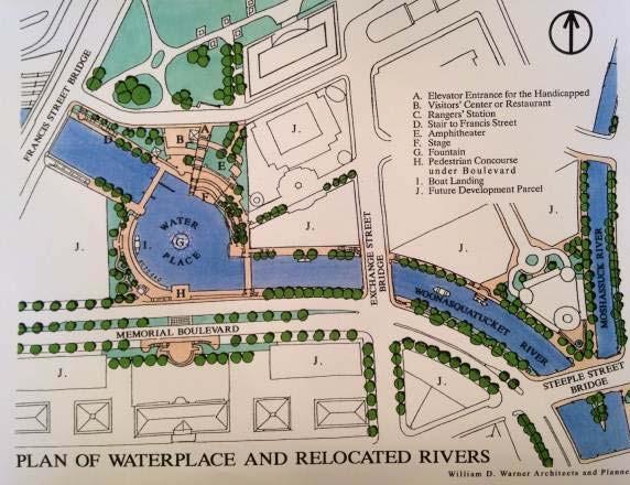
2 Providence History Contemporary interpretation of the Providence landscape in c.1650 View of Providence in 1860 Map of Providence in Map of Providence in 1776 ASLA 2013 Annual Meeting and EXPO
 o Project History; Capitol Center, RR Station relocation, Memorial Boulevard o Project chronology, funding 2.")

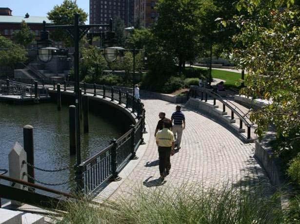
3 Waterplace Park and Providence s Riverfront Aerial View 1995 Location of numbered stops and Topics 1. Memorial Boulevard Pedestrian Underpass o Cove history (graphic panels) o Project History; Capitol Center, RR Station relocation, Memorial Boulevard o Project chronology, funding 2. Waterplace Park, 3. Riverwalk o Waterfire; tidal affects, logistics, human experience o Hydrology, tides, flooding, sediment o Maintenance, ADA issues o Woonasquatucket River, Providence Place Mall o Relocated riverbed 4. Exchange Street Bridge o Bridges (utilities carried under decking) o Water access, Docks for Blackstone River Ferry. Now services gondolas and river tour o Riverwalk edge treatments, details 5. Steeple Street 6. Confluence o Historic references; cove & flood markers, graphic panels o Mossashuck River, History of Confluence o Boat and wood storage for Waterfire 7. Washington Street, 8. College Street o Worlds widest bridge. Suicide Circle. o Reuse of granite, original bridge piers o River under Memorial Blvd at Courthouse o South-WWI Monument 9. I-195 Relocation Project, 10. View to future Parks o First two contracts built to continue riverwalks o Final contracts to be constructed 2016 to complete the riverwalks to include two parks and a pedestrian bridge. Map with tour route and numbered stops. ASLA 2013 Annual Meeting and EXPO


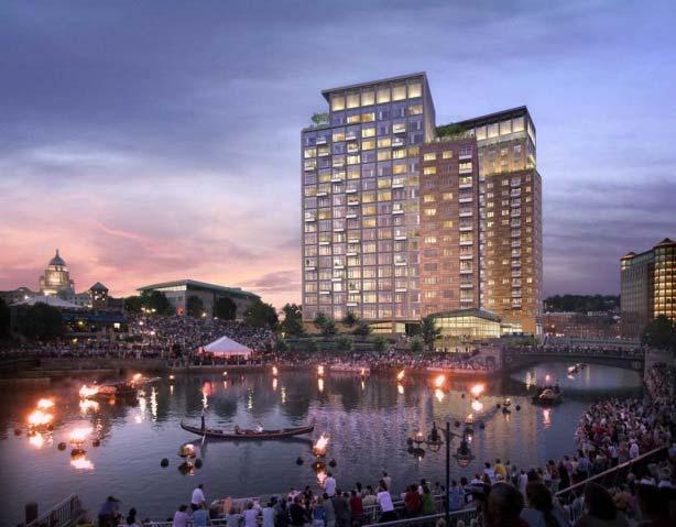
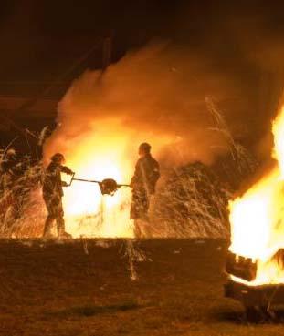
4 1. Memorial Boulevard Pedestrian Underpass, Project History Woonasquatucket River and Providence Rail Yard Waterplace Park, 3. Riverwalk Waterfire


5 4. Exchange Street Bridge 5. Steeple Street 6. Confluence Early rendering Graphic Panels were installed along the walkway. Treatment at river edge River confluence looking south


6 7. Washington Street 9. I-195 Relocation Project Granite was reused throughout the project Suicide Circle & the worlds longest bridge 8. College Street Construction 10. View Future Park Locations WWI monument & Gardner Jackson Park College St. Bridge


7 The Steel Yard & Box Office, Woonasquatucket River Valley Map 1. The Steel Yard o Industrial valley history o Project history o Remediation & design strategies o Project chronology, funding 2. The Box Office o Project history o Remediation & design strategies o Sustainable strategies o Construction


8 Woonasquatucket River Valley History Map of Providence in Fill operations in Woonasquatucket Industrial Valley: Northeast corridor rail line and road on alignment of present day I- 95 Map of Providence in 1776

9 Woonasquatucket River Valley History Postcard, Woonasquatucket River & Promenade Street, mailed 1911 Fill operations in Woonasquatucket Industrial Valley: New York-Boston rail line and road on alignment of present day I- 95 Map of Providence in 1776 Photographs, late 1800s


10 Providence Steel & Iron, Existing conditions, 2007 Postcard, Woonasquatucket River & Promenade Street, mailed 1911 Steel shapes inventory in front of corner building, c1930 Corner building prior to construction of office, c1920

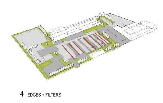
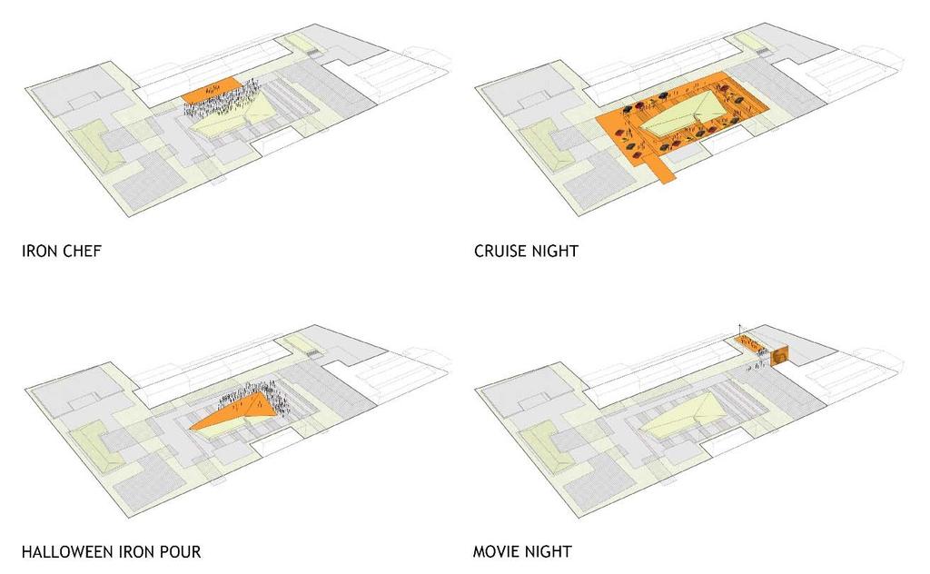
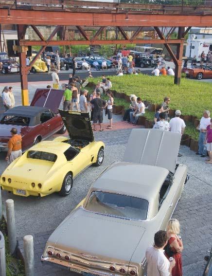
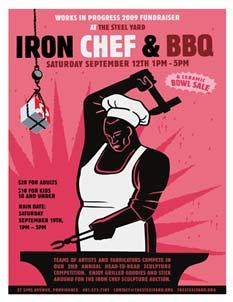
11 Design Strategies Event Programming Diagrams Organizational Strategy


12 Design Strategies Remediation Cap Strategy Sheet pile retaining walls in construction Volunteer planting day, colored buckets denoting clean and contaminated fill


13 Project Timeline Movie Room, autumn 2010 Movie Room, spring 2012


14 The Box Office Preliminary design sketch HABS photo, c1920; aerial site plan of existing conditions Construction photo, 2010


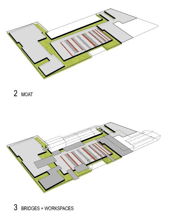
15 The Box Office 3 rd Circulation Diagram, Stormwater Moat Cuts 2 nd Axonometric 1 st


16 see construction video by Stack + Co (general contractors and CM): The Box Office
 The News Press August 31, 2015 Edison river retreat to be recreated By Laura Ruane http://www.news-press.com/story/news/2015/08/29/edison-ford-estates-add-riverfrontpavilion-social-educational-group-use/71319740/
From and
 GREEN INFRASTRUCTURE IN PROVIDENCE, RI The Box Office From http://web.uri.edu/riss/the-box-office/ and http://www.morrisbeacon.com/media/portfolioprojects/implementation/box-office/box%20office.pdf: At
Riverfront Development Plan
 Planning Studies Project Overview: Continuity Developing Fort Myers underused riverfront was the final step in Downtown redevelopment. To mine all facets of the riverfront, the Plan had to be created cohesively
Main Street Conversion Site
 Main Street Conversion Site Borough of Brooklyn, New York Preliminary Presentation Park Expansion Design & Development Committee 13 September 2012 Michael Van Valkenburgh Associates, Inc. Landscape Architects,
City of Poughkeepsie Waterfront Redevelopment Strategy. Poughkeepsie Waterfront Redevelopment Strategy
 City of Poughkeepsie Waterfront Redevelopment Strategy Poughkeepsie Waterfront Redevelopment Strategy City of Poughkeepsie Prime Assets: Major Waterfront Advantages: - Central City of the Hudson River
Newark Riverfront Parks March 10, 2009 Community Meeting
 Newark Riverfront Parks March 10, 2009 Community Meeting Goals of this meeting 1 SHARE OUR KNOWLEDGE about the Newark Riverfront Parks. 2 BUILD SUPPORT for Newark Riverfront Parks. 3 GATHER YOUR KNOWLEDGE
To qualify for federal Transportation Enhancement (TE) funds a project must meet two basic federal requirements:
 funds a project must meet two basic federal requirements:") Eligibility Requirements To qualify for federal Transportation Enhancement (TE) funds a project must meet two basic federal requirements: 1) Relate to surface transportation and 2) Be one of the 12 designated
Eligibility Requirements To qualify for federal Transportation Enhancement (TE) funds a project must meet two basic federal requirements: 1) Relate to surface transportation and 2) Be one of the 12 designated
Lynn Waterfront Master Plan
 Lynn Waterfront Master Plan DECEMBER ALTERNATIVES PRESENTATION City of Lynn / EDIC ZHA / GEI Work Schedule June Kick-Off June September Site Analysis & Property Owner / Stakeholder Meetings September Analysis
FRI-A05: INFRASTRUCTURE, RESILIENCE, and PUBLIC SPACE. E450B, Level 4 Friday, November 6, am-10am
 FRI-A05: INFRASTRUCTURE, RESILIENCE, and PUBLIC SPACE E450B, Level 4 Friday, November 6, 2015 830am-10am DESCRIPTION Infrastructure, Resilience, and Public Space What role does infrastructure play in realizing
Oroville Area Urban Greening Plan. Second Communitywide Workshop
 Oroville Area Urban Greening Plan Second Communitywide Workshop Monday, November 18, 2013 PROJECT TEAM Lead Agency Butte County Department of Development Services Claudia Stuart, Principal Planner Chris
Public Meeting #3 May 9, 2009 MVVA Team
 Public Meeting #3 May 9, 2009 MVVA Team Welcome to the third Public Meeting for the Lower Don Lands Municipal Class Environmental Assessment (EA) Infrastructure Master Plan and Keating Channel Precinct
Purpose of Open House #3
 Public Meeting #3 May 9, 2009 MVVA Team Purpose of Open House #3 The main purpose of this Open House is to present and seek input on the: Evaluation of transportation and infrastructure design alternatives
Learning Objectives. SAT-AO1 Inside the LA Studio with PWP Landscape Architecture
 Learning Objectives SAT-AO1 Inside the LA Studio with PWP Landscape Architecture Peter Walker, FASLA David Walker Adam Greenspan, ASLA Sandy Harris PWP Presenters Chris Dimond, FASLA Jay Swaintek, ASLA
Providence Waterfront Park
 I-195 Redevelopment Parcels Providence Waterfront Park June 30, 2014 I-195 30% Design Review 1 November 19, 2012 endorses open space design. 2 Design Chronology October 2013 10% Design Submitted for both
City of Plattsburgh DRI: Downtown Streetscapes & Riverfront Access. Downtown Streetscape and Riverfront Access Design
 City of Plattsburgh DRI: Downtown Streetscapes & Riverfront Access Welcome Thank you for coming this evening. Agenda PART I - Project Context The Downtown Revitalization Program Our DRI Projects Other
Case Study Presentation of the Downtown Brampton Flood Protection Class EA
 Case Study Presentation of the Downtown Brampton Flood Protection Class EA Presented by: Kenneth M. Dion, Project Director Port Lands Integration, Waterfront Toronto (formerly Senior Manager, TRCA) At:
Blue Line LRT Extension
 v e Noble Pkwy Noble Pkwy Xerxes Ave N Shingle Creek Penn Ave N Penn Ave N Fremont Ave N Lyndale Ave N S Washington Ave University Ave NE Blue Line LRT Extension LIGHT RAIL PLATFORM AND STATION DESIGN
Presented by Catherine Williams, Public Art Consultant. In Attendance Neil Pattison, The Daniels Corporation. Introduction and Context
 Public Art Plan East Bayfront Precinct Daniels Waterfront: City of the Arts Complex 130-132 Queens Quay East & 143-177 Lake Shore Boulevard East & 26 Richardson Street Toronto, Ontario Presented September
Libby Zemaitis October 18, 2017 Climate Outreach Specialist, NYS DEC Hudson River Estuary Program
 1 Supporting Hudson Riverfront communities as Climate-Adaptive Leaders Libby Zemaitis October 18, 2017 Climate Outreach Specialist, NYS DEC Hudson River Estuary Program The Hudson River Estuary Program
Public Art Ideas Competition 2013
 Connect Historic Boston Public Art Ideas Competition 2013 Regional New England Opportunity CALL TO STUDENT ARTISTS + DESIGNERS Overview This is a student competition for Public Art proposals that engage
Northeast Anthony Henday Drive Manning Freeway to Whitemud Drive Welcome to this Construction Information Session
 Manning Freeway to Whitemud Drive Welcome to this Construction Information Session Purpose To inform interested residents and businesses about the plans accommodation. Background: The Government of Alberta
Envision Courthouse Square. Cultural Resources, Circulation, Open Space, & Buildings
 Envision Courthouse Square Cultural Resources, Circulation, Open Space, & Buildings May 21, 2014 Envision Courthouse Square Cultural Resources Existing Conditions Historic Preservation Program May 21,
MEADOW RIVER RAIL TRAIL
 MEADOW RIVER RAIL TRAIL Nicholas, Fayette and Greenbrier Rail Line CSX Abandonment 2008 Greenbrier and Fayette County Partnership 2009 16.7 mile Purchased in July 2011. Trail Development Begins: Obama
Link Union Station (Link US) Project Open House September 26, 2018
 Project Open House September 26, 2018") Link Union Station (Link US) Project Open House September 26, 2018 Major Project Components 1. New rail communication, signals, and tracks 2. New run-through tracks over US-101 and new loop track 3. New
Link Union Station (Link US) Project Open House September 26, 2018 Major Project Components 1. New rail communication, signals, and tracks 2. New run-through tracks over US-101 and new loop track 3. New
SELMON GREENWAY FEASIBILITY STUDY. For: Hillsborough County Metropolitan Planning Organization By: Renaissance Planning
 SELMON GREENWAY FEASIBILITY STUDY For: Hillsborough County Metropolitan Planning Organization By: Renaissance Planning SELMON GREENWAY FEASIBILITY STUDY VISION Multimodal connection between Bayshore Blvd
Costal Sustainability and Green Streets, Mobile, Alabama
 Costal Sustainability and Green Streets, Mobile, Alabama A Green Infrastructure Plan for Mobile, Alabama Charlene LeBleu, AICP, ASLA Auburn University Landscape Architecture School of Architecture College
A Plan for the Heart of the Region: Tukwila, WA
 : Tukwila, WA 1 The Plan orchestrates the Restructuring of a 1,000-acre Regional Shopping Area into a Social and Symbolic for the Region. REGIONAL CONTEXT Downtown Seattle (Metropolitan ) 20 miles Bellevue
JACKsON STREET PIER CONCEPTUAL DESIGN PACKAGE SEPTEMBER 21, 2017
 JACKsON STREET PIER CONCEPTUAL DESIGN PACKAGE SEPTEMBER 21, 2017 JACKsON STREET PIER Process outline DESIGN PROCESS OVERVIEW: Sandusky s Jackson Street Pier Conceptual Design process included input from
FINAL MITIGATION PLAN to address
 CENTRAL CORRIDOR LRT STATE CAPITOL MALL HISTORIC FINAL MITIGATION PLAN February 2010 FINAL MITIGATION PLAN to address Adverse Effects of the Central Corridor LRT Project on the State Capitol Mall Historic
ROUND ONE PROJECTS. Capital Grants 18 DELAWARE VALLEY REGIONAL PLANNING COMMISSION
 ROUND ONE PROJECTS DVRPC awarded the first round Take Me to the River grants in 2008 (see Figure 5 for project locations). The 13 projects selected were chosen based on their ability to reconnect citizens
DRAFT ROOSEVELT ROAD. District Recommendations. Figure 5.23 The Roosevelt Road Corridor
 CHAPTER 5 Figure 5.23 The Road Corridor Road will develop as a mixed-use corridor, emphasizing regional retail, west of the river and mixed-use development east of the river. KEY RECOMMENDATIONS 1. High
TIMOTHY E. DATERS, P.E. White-Daters & Associates, Inc. 24 Rahling Circle Little Rock, AR (501)
") TIMOTHY E. DATERS, P.E. tdaters@whitedaters.com Graduated from University of Iowa, 1975, BSCE Recipient of Fred Stebler Scholarship Graduated from University of Arkansas, 1983, MSCE PROFESSIONAL ORGANIZATION
TIMOTHY E. DATERS, P.E. tdaters@whitedaters.com Graduated from University of Iowa, 1975, BSCE Recipient of Fred Stebler Scholarship Graduated from University of Arkansas, 1983, MSCE PROFESSIONAL ORGANIZATION
Anatomy of A Vibrant Downtown. Anatomy of a Vibrant Downtown
 Anatomy of A Vibrant Downtown The goal of MAIN ST. REVITALIZATION PLANNING is to provide a framework that will help transform your downtown into a VIBRANT DOWNTOWN a place where people love to LIVE, WORK,
VISUALIZATION TOOLS FOR COMMUNICATION & DECISION MAKING REAL MINNESOTA EXAMPLES
 REAL MINNESOTA EXAMPLES 23rd Annual CTS Transportation Research Conference Leif Garnass, P.E., PTOE Senior Engineer lgarnass@srfconsulting.com Sean Jergens, ASLA, LEED AP Senior Landscape Architect sjergens@srfconsulting.com
Potential Green Infrastructure Strategies May 6, 2015 Workshop
 Potential Green Infrastructure Strategies May 6, 2015 Workshop Background The City of Cortland is developing the Tioughnioga Urban Headwaters Green Infrastructure Action Plan with funding from the National
preliminary master plan Cover Slide executive summary public presentation
 preliminary master plan public presentation executive summary Cover Slide {agenda} + Master Plan Process + Context and Overviews + Preliminary Concepts - Entry/Gateways - Core District - Streetscape +
WOONASQUATUCKET RIVER WATERSHED COUNCIL REQUEST FOR PROPOSALS DESIGN OF GREENWAY PALETTE, SIGNAGE AND AMENITIES
 WOONASQUATUCKET RIVER WATERSHED COUNCIL REQUEST FOR PROPOSALS DESIGN OF GREENWAY PALETTE, SIGNAGE AND AMENITIES PROJECT BACKGROUND The Woonasquatucket River Watershed Council (WRWC) is a 501(c)3 organization
HURON WATERFRONT DEVELOPMENT AND AMPHITHEATER
 AWARD WINNING PROJECT Location Huron, Ohio Architectural, Engineering, Site, Landscaping, Planning, Survey, Grant Administration, Construction Administration Cost $285,000 Amphitheater $300,000 Marina
Chapter 8. Visualizations
 Examples of Effective Techniques for Improving the Quality of Environmental Documents Chapter 8. Visualizations Visualizations help the reader to see what the project would look like in the real world.
ASHTABULA COUNTY COASTAL MANAGEMENT PLAN
 Location Ashtabula County, Ohio Planning Grantwriting ODNR, Office of Coastal Management, $25,000 Local Match $25,000 Size 21 miles of coastal area Professional Services 2012 Project Team Randy Mielnik,
Lynn Waterfront Master Plan
 Lynn Waterfront Master Plan Public Meeting #2 December 10th, 2018 1 Project Schedule Update September 26, 2018 December 10, 2018 Development of the Master Harbor Plan Amendment and Revised Waterfront Master
STRIP PORTALS. Concept Plan. December 2008 page 1. PFAFFMANN + ASSOCIATES 223 Fourth Avenue Pittsburgh, PA
 Concept Plan PFAFFMANN + ASSOCIATES 223 Fourth Avenue Pittsburgh, PA 15222 412.471.2470 December 2008 page 1 Concept Plan Project Summary Project Team Neighbors in the Strip 1212 Smallman Street Pittsburgh,
Creation of Confluence Park and Input from Vermont River Conservancy
 CITY COUNCIL Agenda Item #18-236 Date: August 22, 2018 Consent Discussion X SUBJECT: Creation of Confluence Park and Input from Vermont River Conservancy SUBMITTING DEPARTMENT: Mayor RECOMMENDED ACTION:
QUESTIONS AND ANSWERS Windsor Woods, Princess Anne Plaza & The Lakes Combined Drainage Project
 QUESTIONS AND ANSWERS Windsor Woods, Princess Anne Plaza & The Lakes Combined Drainage Project PROJECT OVERVIEW Windsor Woods, Princess Anne Plaza and The Lakes are neighborhoods located in what was once
Notes from table discussions at the Metro North Regional Forum in Malden on April 30, 2014
 Notes from table discussions at the Metro North Regional Forum in Malden on April 30, 2014 These notes represent a summary of the themes, locations, and discussions that were discussed as part of the facilitated
Derby-Shelton Bridge Pedestrian and Bicyclist Enhancements [1]
![Derby-Shelton Bridge Pedestrian and Bicyclist Enhancements [1]](/thumbs/96/128011958.jpg "Derby-Shelton Bridge Pedestrian and Bicyclist Enhancements [1]") nhancements [1] STATUS OF PROJECT: The project has recently moved from the Preliminary Design Phase to the Final Design Phase following the most recent Public Involvement Meeting held on January 9, 2019
nhancements [1] STATUS OF PROJECT: The project has recently moved from the Preliminary Design Phase to the Final Design Phase following the most recent Public Involvement Meeting held on January 9, 2019
Multimodal Station Planning Working Session Rebuilding a Better I-84 in Hartford. August 10, 2017
 Multimodal Station Planning Working Session Rebuilding a Better I-84 in Hartford August 10, 2017 Station Urban Design Principles + Guidelines Station Urban Design Principles + Guidelines The station should
The World Trade Center as an Integrated Landscape
 SUN-B01 The World Trade Center as an Integrated Landscape The World Trade Center redevelopment tends to be overlooked as a cohesive landscape architecture project. While individual elements One World Trade
Lynn Housing Authority and Neighborhood Development. Washington Street Gateway District Plan A p r i l
 Lynn Housing Authority and Neighborhood Development Washington Street Gateway District Plan A p r i l 2 0 0 8 rendering of sagamore hill from lynnway pedestrian overpass table of contents project area
Chinatown. Green Street Demonstration Project. land + water. community
 Chinatown Green Street Demonstration Project land + water community 2 Purpose. Dear Stakeholder, Thank you for your interest in making our neighborhood a greener, more sustainable, and attractive place
Learning Objectives. Introduction. Design at an Ecodistrict Scale can Change Washington, DC s Landscape
 Learning Objectives Design at an Ecodistrict Scale can Change Washington, DC s Landscape Presenters Elizabeth Miller, ASLA, National Capital Planning Commission Diane Sullivan, National Capital Planning
Master Planning: Cuba, New York Phase II. Dr. John Anderson President Alfred State College. Alfred New York
 Master Planning: Cuba, New York Phase II Dr. John Anderson President Alfred State College Alfred, New York 14802 607-587-4211 February 1, 2011 June 30, 2012 March 5, 2012 Craig R Clark, PE Dean, School
APPENDIX C Township 9 Consistency with Applicable Plans
 Township 9 Consistency with Applicable Plans 1985 American River Parkway Plan Policies Project Consistency Policy 4.14: The following activities and facilities, which are incompatible with the Parkway,
TURN TO THE RIVER CITY PLAZA LANDSCAPE DESIGN CONCEPT May 25, 2016
 Turn to the River is a multi-year project of Art Spaces - Wabash Valley Outdoor Sculpture Collection, Inc. to connect downtown Terre Haute with the Wabash River through public art and design. The four-square
A. INTRODUCTION B. NO ACTION ALTERNATIVE
 Chapter 19: Alternatives A. INTRODUCTION Over the years a variety of potential developments for the East River waterfront in Lower Manhattan have been considered. Some of these plans were very ambitious
Spring 2018 Construction Update
 Spring 2018 Construction Update Ward 3 Southwest Engineering Department Locust Street Bridge over the Des Moines River The Locust Street Bridge over the Des Moines River project is being let through the
Downtown Dubuque...it s a great time.
 Downtown Dubuque...it s a great time. Your timing could not be better to invest in Downtown. With hundreds of millions in public and private investment occurring on the City s downtown waterfront, millions
I-84 Hartford Project Open Planning Studio #12. April 25, 2017
 I-84 Hartford Project Open Planning Studio #12 April 25, 2017 Meeting Agenda 1. I-84 Hartford Project alternatives update 2. Multimodal station area planning 3. I-84 / I-91 Interchange Study coordination
3. Relevant Planning Documents / Planning Initiatives
 Chapter Two Physical Inventory and Analysis 1. Methodology The consultant performed several initial site reconnaissance trips in the winter of 2004 to inventory, analyze, and document the physical conditions
THE NEIGHBORHOOD TODAY
 THE NEIGHBORHOOD TODAY CORE AREA VISION How are we Good Urbanism A Site s DNA thinking about Elements of great Unique elements urban communities embedded in a place the site and design? ELEMENTS LIKE:
SQUAMISH 2010 AND BEYOND COMMUNITY VISION
 Our plan has been imagined and created to be both pragmatic and visionary. At the core of the strategy is a consideration of the highway s role and its impact on the community. First and foremost in creating
Xeriscape. Xeriscape & Green Technologies. Technologies. Background. Agenda. Background. Xeriscape and Green. George Radnovich
 Xeriscape Xeriscape & Green George Radnovich, ASLA Sites Southwest LLC Definition Place based landscaping that meets the needs of today s world, without diminishing the ability of future generations to
BRADENTON RIVERWALK EXPANSION MASTER PLAN
 BRADENTON RIVERWALK EXPANSION MASTER PLAN INTRODUCTION & AGENDA Process Update Community Engagement Summary Center for Active Design (CfAD) Recommendations Context and Existing Conditions Master Plan Alternatives
CITIZEN S ADVISORY COMMITTEE PUBLIC REALM CONCEPT PRESENTATION. October 25, 2018
 CITIZEN S ADVISORY COMMITTEE PUBLIC REALM CONCEPT PRESENTATION October 25, 2018 AGENDA Placemaking Study Overview Public Space Design Character and Concepts / Updated Visuals PLACEMAKING STUDY OVERVIEW
Lakefront Downtown Action Plan Phase I June 2008
 Lakefront Downtown Action Plan Phase I June 2008 Downtown Development Authority City of Lake Charles Lakefront Overview DDA Chairman Rick Richard DPZ Lakefront Plan May 5 th 2007 $18.5M City Bond Issue
City of Iowa City Department of Neighborhood and Development Services Department of Parks and Recreation Department of Public Works City Manager s
 RFP Pre-submittal meeting December 18, 2015 City of Iowa City Department of Neighborhood and Development Services Department of Parks and Recreation Department of Public Works City Manager s Office Background
12 th Street Connector Alignment Study VISIONING PUBLIC WORKSHOP - JUNE 25, :00PM TO 8:00PM
 12 th Street Connector Alignment Study VISIONING PUBLIC WORKSHOP - JUNE 25, 2018 6:00PM TO 8:00PM Goals for Today s Workshop Agenda: Project Introduction, Purpose, and Goals Existing Conditions Traffic
This is the East Carolina University Comprehensive Facilities Master Plan Final Draft Plan Review. This workbook reviews the campus draft master plan
 This is the East Carolina University Comprehensive Facilities Master Plan Final Draft Plan Review. This workbook reviews the campus draft master plan first presented on campus on June 29 and June 30, 2011.
Thames River Basin Partnership Floating Workshop XVI
 Thames River Basin Partnership Floating Workshop XVI Thames River Basin Partnership The Thames River Basin Partnership is a voluntary, cooperative effort to share organizational resources and to develop
Cleveland Mall / North Coast Harbor Land Bridge Proposal. "Achieving the Ultimate Goal of Merging the Lakefront with Downtown"
 Cleveland Mall / North Coast Harbor Land Bridge Proposal "Achieving the Ultimate Goal of Merging the Lakefront with Downtown" Document prepared by: Green Ribbon Coalition 2800 Euclid Avenue, Suite 510
WELCOME TO OPEN HOUSE TWO November 28, 2018
 Langstaff Road Weston Road to Highway 7 Class Environmental Assessment Study WELCOME TO OPEN HOUSE TWO November 28, 2018 Please sign in and join our mailing list Study Overview York Region is conducting
Turkey Creek Streamway Corridor
 Turkey Creek Streamway Corridor Turkey Creek Corridor Overview History Watershed Corridor Inventory Coalition Corridor Plan Stages of Development Benefits Funding Turkey Creek History Kansas and Missouri
SBPO BOARD MEETING MARCH 20, 2018
 SBPO BOARD MEETING MARCH 20, 2018 TODAY'S AGENDA > Booker Middle School Outreach > Property Information > Schedule > Guiding Principles > Three Concepts Booker Middle School Outreach Property Information
Thank you for coming to the Rail Corridor Land Use Study Public Meeting.
 01 Welcome! Thank you for coming to the Rail Corridor Land Use Study Public Meeting. Tonight is an opportunity to learn about the Land Use Study for the Rail Corridor Site. In Fall 2016, Toronto City Council
LANGAN LANDSCAPE ARCHITECTURE + PLANNING
 LANGAN LANDSCAPE ARCHITECTURE + PLANNING CONTACT HEADQUARTERS Parsippany New Jersey 300 Kimball Drive 4th Floor Parsippany NJ 07054 973.560.4900 973.560.4901 RUTGERS UNIVERSITY - 15 WASHINGTON STREET Newark
Glen Road Pedestrian Bridge Environmental Assessment
 Glen Road Pedestrian Bridge Environmental Assessment Presentation to Design Review Panel July 18, 2017 Glen Road Pedestrian Bridge Class Environmental Assessment STUDY AREA Bloor Street East Streetscape
Burnham s ChiCago Plan of 1909
 Burnham s ChiCago Plan of 1909 Name When the Commercial Club of Chicago commissioned architect Daniel Burnham to produce a plan to guide the city s future economic and physical growth, they were tapping
SPRINGFIELD, MA Technical Assistance Panel (TAP)
") SPRINGFIELD, MA Technical Assistance Panel (TAP) ULI the Urban Land Institute Mission To provide leadership in the responsible use of land and in creating and sustaining thriving communities worldwide.
SPRINGFIELD, MA Technical Assistance Panel (TAP) ULI the Urban Land Institute Mission To provide leadership in the responsible use of land and in creating and sustaining thriving communities worldwide.
Parcel 5. Level 1 Application March 12, Design Submittal POST ROAD RESIDENTIAL
 P:\3371 Providence \graphic\meetings and Presentations\2018.03.12_Level 1 Submission/ I-195 Level Redevelopment 1 Design Submission.pdf District Commission Introduction The Level 1 conceptualization of
NORTH BAY RECREATION AND NATURAL AREA
 HUDSON NORTH BAY RECREATION AND NATURAL AREA City of Hudson, New York Prepared by the Columbia Land Conservancy North Bay: from forgotten waterfront to dynamic public park The proposal for the North Bay
AMSTERDAM S PARK OVER THE RIVER HOW THE MOHAWK VALLEY GATEWAY OVERLOOK RECONNECTED A CITY
 AMSTERDAM S PARK OVER THE RIVER HOW THE MOHAWK VALLEY GATEWAY OVERLOOK RECONNECTED A CITY Presentation Overview Background Design Process and Goals Concepts Design Development Public Participation Process
Sourisseau. Sourisseau Academy. St. James Square. Les Amis (The Friends) June Smith-Layton Archive presents: by Charlene Duval
 June Smith-Layton Archive presents: by Charlene Duval") Academy Smith-Layton Archive presents: St. James Square Charlene Duval, Execu ve Secretary cduval@sourisseauacademy.org Leilani Marshall, Archivist lmarshall@sourisseauacademy.org Phone: 408 808 2064 by
Academy Smith-Layton Archive presents: St. James Square Charlene Duval, Execu ve Secretary cduval@sourisseauacademy.org Leilani Marshall, Archivist lmarshall@sourisseauacademy.org Phone: 408 808 2064 by
Fairfax Boulevard Complete Street
 Fairfax Boulevard Complete Street 100 Plus Year Vision We are a Bedroom Community. A Decade-Long Partnership Charles Town- Ranson Commerce Corridor Council launched in 1999. Consisted of local/state/federal
03 HIGH PRIORITY SITES
 03 HIGH PRIORITY SITES HOWARD PARK Howard Park is one of South Bend s largest riverfront parks, hosting nearly acres. Howard Park has a very passive landscape with a recreation building, ice skating rink,
CAPITAL GATEWAY CONCEPT PLAN
 CAPITAL GATEWAY CONCEPT PLAN Purpose & Goals of the Concept Plan The Purpose: Develop an urban design strategy Identify recommended infrastructure design elements The Goal: Maximize short- and long-term
STUDY AREA. Tonight s Agenda. Project Tasks Completed. Next Steps. Town of Oyster Bay Eastern Waterfront Community Vision & Revitalization Plan
 Town of Oyster Bay Eastern Waterfront Community Vision & Revitalization Plan Public Meeting January 27, 2009 Opening Remarks Presentation Tonight s Agenda Introduction Study Area Overview Public Participation
Billing Code: DEPARTMENT OF HOUSING AND URBAN DEVELOPMENT [Docket No. FR-6072-N-01]
![Billing Code: DEPARTMENT OF HOUSING AND URBAN DEVELOPMENT [Docket No. FR-6072-N-01]](/thumbs/91/107309814.jpg "Billing Code: DEPARTMENT OF HOUSING AND URBAN DEVELOPMENT [Docket No. FR-6072-N-01]") This document is scheduled to be published in the Federal Register on 12/18/2017 and available online at https://federalregister.gov/d/2017-27194, and on FDsys.gov Billing Code: 4210-67 DEPARTMENT OF HOUSING
This document is scheduled to be published in the Federal Register on 12/18/2017 and available online at https://federalregister.gov/d/2017-27194, and on FDsys.gov Billing Code: 4210-67 DEPARTMENT OF HOUSING
How can landscape architects aide in transportation planning process? John Dempsey, PLA Toole Design Group July 24, 2015
 How can landscape architects aide in transportation planning process? John Dempsey, PLA Toole Design Group July 24, 2015 What is Landscape Architecture? Landscape Architecture 1863 What is Landscape Architecture?
Central Platte Valley Auraria District Amendment. Steering Committee Meeting #
 Central Platte Valley Auraria Amendment Steering Committee Meeting #1 4.26.2017 Central Platte Valley Auraria Amendment Welcome of Steering Committee Members Co-Chairs: Tami Door & Bar Chadwick Brief Introductions
Trinity Uptown - Peripheral Zones University Drive/ Jacksboro Highway Zone March 31, 2008
 Trinity Uptown - Peripheral Zones University Drive/ Jacksboro Highway Zone March 31, 2008 TRINITY UPTOWN CHARACTERISTICS Desirable density Residential and mixed uses Active waterfront Public spaces Pedestrian
WHAT MAKES A GREAT PLACE?
 ARCHITECTURAL QUALITY ARCHITECTURAL QUALITY IN THE CORRIDOR ARCHITECTURAL QUALITY The Potential of a Multimodal Terminal Would bring provide alternate forms of transportation to Atlanta s major destinations
CORALVILLE, IOWA IOWA RIVERFRONT MASTER PLAN
 CORALVILLE, IOWA IOWA RIVERFRONT MASTER PLAN MARCH 2012 FRAMEWORK & MASTER PLAN COMMITTEE Kristopher Ackerson, MPOJC Scott Annis, Community Member Nick Benson, Community Member Mary Curtis, Community
WELCOME TACOMA TRESTLE TRACK & SIGNAL PROJECT OPEN HOUSE REVIEW AND COMMENT ON TRESTLE AND PLATFORM PRELIMINARY STRUCTURAL DESIGN
 WELCOME TACOMA TRESTLE TRACK & SIGNAL ROJECT OEN HOUSE REVIEW AND COMMENT ON TRESTLE AND LATFORM RELIMINARY STRUCTURAL DESIGN LEARN ABOUT TIMING FOR AESTHETIC ELEMENTS NEXT STES CURRENT AND FUTURE SOUND
{Best Practices. Summary of Tools, Strategies and Best Practices from 11 Michigan Case Study Communities
 Case Studies Michigan Coastal Community Working Waterfronts { Summary of Tools, Strategies and from 11 Michigan Case Study Communities Table of Contents Zoning...2 Community and Stakeholder Collaboration
Redevelopment of the Senior Campus Community Meetings
 Redevelopment of the Senior Campus Community Meetings Meeting Dates & Topics Note: Dates could change due to unforeseen circumstances. (An additional updated notice will be sent if dates change.) Wednesday,
SARANAC LAKE VISION CONCEPTS
 DRAFT SARANAC LAKE VISION CONCEPTS A GENUINE PLACE TO LIVE, WORK, SHOP AND EXPERIENCE CULTURE IN THE HEART OF THE ADIRONDACKS PHOTO COURTESY OF SARANAC LAKE SARANAC LAKE, NEW YORK DECEMBER 2007 SARANAC
open house 3 CITY OF SALEM Downtown Streetscape Plan
 open house 3 Streetscape concepts CITY OF SALEM Downtown Streetscape Plan analysis concepts we are here refined concepts & document Feb 13th 1 2 3 apr 18th KICKOFF OPEN HOUSE Streetscape Work Group Walking
1.1 WATERFRONT SEATTLE
 1.1 WATERFRONT SEATTLE Over the past few years, the City of has been actively re-imagining the future of its Central Waterfront. The imminent replacement of the Elliott Bay Seawall and removal of the Alaskan
UNIVERSITY OF NORTHERN IOWA
 UNIVERSITY OF NORTHERN IOWA Municipal Separate Storm Sewer System 2015/2016 Report Permit Number 07-09-0-04 August 2016 Prepared by: Environmental Health and Safety Office University of Northern Iowa 8628
Niagara National Heritage Area
 Niagara National Heritage Area What is a National Heritage Area? It is a regional place where natural, cultural, historic and recreational resources combine to form a nationally distinctive landscape and