City of Poughkeepsie Waterfront Redevelopment Strategy. Poughkeepsie Waterfront Redevelopment Strategy
|
|
|
- Geoffrey Nash
- 5 years ago
- Views:
Transcription


1 City of Poughkeepsie Waterfront Redevelopment Strategy Poughkeepsie Waterfront Redevelopment Strategy

2 City of Poughkeepsie Prime Assets: Major Waterfront Advantages: - Central City of the Hudson River Valley - Prime Hudson River Frontage - Center for Colleges, Hospitals, and Culture - Framed by Two Historic Bridges - High Quality Housing and Historic Districts - Railroad Connections to NYC - Dutchess County Government Seat - Large Public Parks - Crossroads of Two Regional Trail Systems - Walkway Over the Hudson Poughkeepsie Waterfront Redevelopment Strategy


3 Poughkeepsie Waterfront Redevelopment Strategy Overall Goal #1: Build a Continuous Greenway Trail along the Riverfront. 4 Major Gaps: Marist North Campus Dutton & Central Hudson Kaal Rock Point South of Hudson Pointe One Connected Waterfront
4 Overall Goal #2: Knit Together Surrounding City Plans and Projects. Walkway-Gateway Zoning District Middle Main Fall Kill Creek Plan City Center Revitalization Plan Walkway Branding One Dutchess Avenue Elevator and Upper Landing Kaal Rock Plan Southern Waterfront

5 Overall Goal #3: Create a High-Quality Waterfront Park and Regional Destination Between Main Street, the Railroad Station, and Walkway Elevator. Walkway-Gateway Zoning District Middle Main Fall Kill Creek Plan City Center Revitalization Plan Walkway Branding One Dutchess Avenue Elevator and Upper Landing Kaal Rock Plan Southern Waterfront

6 Railroad Station Railroad Properties Private Property City Parkland Private Property Waterfront Area Property Ownership


7 Access segmented into three dead-end parking areas. Pedestrian paths are limited and not ADA-compliant. Existing Waterfront Dominated by Parking Lots


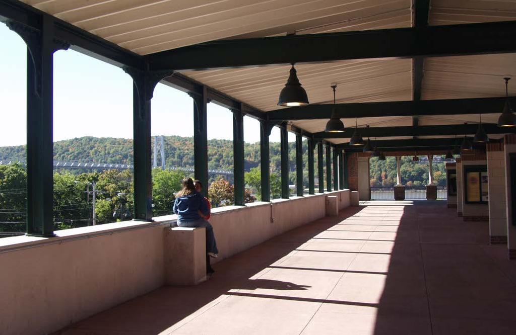

8 Existing Views from Station Overpass
9 Children s Museum Bridge to Elevator Park Plaza Grand Stairs Learning Landscape Stage Event Lawn Garden Paths Boat House Ice House Band Stand Playground Fishing Pier Boat Docks Kayak Launch Main Street Pier Kaal Rock Park A New Front Porch for Poughkeepsie North-south path network integrates a wide variety of new park features; Park plaza replaces parking lots at gateway entrance from Station overlook; New commercial attractions are focused around Main and Water Streets. Illustrative Plan New Building Existing Building Parking Structure


10 4 5 story buildings along North Water Street Covered walkways around Railroad Station 1831 Public Market Hall Children s Museum Bridge to Elevator Park Plaza Grand Stairs Stage Event Lawn Learning Landscape Garden Paths Boat House Ice House Band Stand Fishing Pier Boat Docks Kayak Launch Main Street Pier Kaal Rock Park Poughkeepsie Waterfront Precedents Active docking and waterfront hotel 1799 Map showing a central stream Main Street Steamboat Pier for tour boats

11 Children s Museum Bridge to Elevator Park Plaza Learning Landscape Stage Event Lawn Garden Paths Grand Stairs Boat House Ice House Band Stand Playground Fishing Pier Boat Docks Kayak Launch Main Street Pier Kaal Rock Park Potential New Development: Retail/Restaurants 70,000 Sq. Ft. Hotel Rooms Offices 10,000 Sq. Ft. Apartments 207 Units Park Plaza Buildings 18,000 Sq. Ft. Townhouses 56 Units Illustrative Plan New Building Existing Building Parking Structure


12 View West from Station Overlook, Before and After View North along Water Street, Before and After


13

14


15 Natural Area Community Park Urban Riverfront Plaza and Promenade Revitalizing Hudson Riverfronts 2010 Range of Waterfront Activities along a Continuous Greenway Corridor Linear Park
16 Contact Information Eoin Wrafter, ACIP Commissioner Dutchess County Department of Planning & Development 27 High Street Poughkeepsie, NY Phone: Fax: Website: Dutchess County Planning and Development
Poughkeepsie Waterfront Redevelopment Strategy. Poughkeepsie Waterfront Redevelopment Strategy
 Poughkeepsie Waterfront Redevelopment Strategy Poughkeepsie Waterfront Redevelopment Strategy City of Poughkeepsie Common Council: Mayor John C. Tkazyik Chair Christopher D. Petsas 1st Ward Anne E. Perry
...to here? we ve got to go...
 How do we get from here... Can t go through it, can t go under it......to here? we ve got to go... Poughkeepsie Connected Linking together the city s waterfront Past Planning Projects 1. Local Waterfront
MCCOYS CREEK RESTORATION 30% DESIGN
 MCCOYS CREEK RESTORATION 30% DESIGN THE MCCOYS CREEK RESTORATION PLAN The restoration plan aims to reduce flooding, restore ecosystem health, expand recreational opportunities along the creek, and connect
Highland Falls Waterfront Redevelopment Feasibility Study Village Board Meeting March 20, 2017
 Village Board Meeting March 20, 2017 Agenda I. Public Meeting #1 Visioning Summary II. Public Meeting #2 Comment Summary III. IV. IV. Case Study: Milton Train Station Schematic Design Concepts Schedule/Next
DRAFT ROOSEVELT ROAD. District Recommendations. Figure 5.23 The Roosevelt Road Corridor
 CHAPTER 5 Figure 5.23 The Road Corridor Road will develop as a mixed-use corridor, emphasizing regional retail, west of the river and mixed-use development east of the river. KEY RECOMMENDATIONS 1. High
Site 1: Roxy s Cleaners
 Site 1: Roxy s Cleaners 395 Main Avenue Antfil Realty LLC SBL #: 124.6-8-9.11 Acres: 0.43 Current Use/ Status: The property is vacant and part of the NYSDEC State Superfund Program, Classification 04 properly
ROME WATERFRONT VILLAGE PROJECT NARRATIVE January 25, 2018
 January 25, 2018 The Rome Waterfront Village project is intended to foster the revitalization of the area between South James Street and Erie Boulevard north of the Erie Canal as well as improve public
4 C OMMUNITY D ISTRICTS
 4 C OMMUNITY D ISTRICTS N ew development in the Area will include many different types of land uses, including a destination retail area that attracts people from all over the region; recreation opportunities
Trail Feasibility and Planning Project for Northern Dutchess County, New York
 for Northern Dutchess County, New York Funded in Part by Grants from the Hudson River Valley Greenway, Land Trust Alliance Conservation Partnership Program and the Thomas Thompson Trust 1 STEERING COMMITTEE
1.1 WATERFRONT SEATTLE
 1.1 WATERFRONT SEATTLE Over the past few years, the City of has been actively re-imagining the future of its Central Waterfront. The imminent replacement of the Elliott Bay Seawall and removal of the Alaskan
SAVONA, NEW YORK. A V i s I o n f o r S u s t a I n a b i l I t y a n d G r o w t h
 SAVONA, NEW YORK A V i s I o n f o r S u s t a I n a b i l I t y a n d G r o w t h URBAN DESIGN STUDIO DECEMBER 6, 2014 WHAT IS THE URBAN DESIGN STUDIO? The Urban Design Studio focuses on the design of
FOR SALE OR LEASE ±12,600 SQ. FT. AUTO/TRUCK SERVICE FACILITY
 FOR SALE OR LEASE ±12,600 SQ. FT. AUTO/TRUCK SERVICE FACILITY FOR ADDITIONAL INFORMATION, CONTACT 2 TAYLOR AVENUE CITY OF POUGHKEEPSIE, NY James Martin Senior Vice President Exclusive Broker BUILDING:
Title slide..poughkeepsie Planning Initiatives POUGHKEEPSIE PLANNING INITIATIVES
 Title slide..poughkeepsie Planning Initiatives Overview Revitalization Projects Waterfront Redevelopment Strategy Local Waterfront Revitalization Program Update Kaal Rock Connector Fallkill Creek Plan
PRELIMINARY DESIGN + DEVELOPMENT PLAN
 WELCOME! To The Public Open House May 30 th, 2017 HARBOUR WEST PARKS Vision Project Overview The City s vision for Port Credit Harbour West Parks is to develop a vibrant waterfront destination that integrates
City of Plattsburgh DRI: Downtown Streetscapes & Riverfront Access. Downtown Streetscape and Riverfront Access Design
 City of Plattsburgh DRI: Downtown Streetscapes & Riverfront Access Welcome Thank you for coming this evening. Agenda PART I - Project Context The Downtown Revitalization Program Our DRI Projects Other
M i s s i o n B a y W a t e r f r o n t
 114 M i s s i o n B a y W a t e r f r o n t Character of the Area: The Mission Bay Waterfront extends from Pier 48 at China Basin Channel to 18th Street in the Central Basin. This area of the waterfront
Urban Analysis. Downtown Zanesville like any city, has been physically modified through time as it
 Urban Analysis As a part of the consulting team s reconnaissance effort, an urban analysis was performed. Before the future of a place can be envisioned, one must understand the physical characteristics
A Vision for Walnut Creek
 A Vision for Walnut Creek Photo: City of Clive Walnut Creek Booklet 8 of 8 Greater Des Moines Water Trails and Greenways 1 Table of Contents Booklet 1: Water Trails Strategies and Policies Booklet 2: Beaver
Burnside Gorge Neighbourhood Plan. Engagement Summary
 Burnside Gorge Neighbourhood Plan Engagement Summary Table of Contents Engagement Summary... 3 Phase One Engagement (April May 2015)... 4 Phase Two Engagement (January March 2016)... 4 Appendix One: Summary
Town Center. Block 5 Existing multifamily residential units are expected to remain.
 Area Guidelines Germantown s districts should be developed as distinct communities with unique features that are supported through the guidelines. The guidelines not only help distinguish these districts
Illustrative Development Plan
 Illustrative Development Plan December 7, 005 045 Sansome St., Studio 3 San Francisco, CA 94 Area A - Increase visibility to waterfront and aquatic center from the Embarcadero - Provide streets rather
Seneca Meadows. Block 4 Locate office, technology, and medical development adjacent to I Screen views of garage structures from I-270.
 Seneca Meadows Seneca Meadows has an industrial park in its southern end and a mixed-use employment area planned for the north end. The district benefits from extensive I-270 visibility, stream valley
Waterfront Development Master Plan
 PORT of VANCOUVER USA Vancouver, WA Waterfront Development Master Plan DRAFT - FINAL CONCEPTUAL MASTER PLAN PROJECT TEAM NBBJ Heritage Research Associates JLA Kittelson Associates Leland Consulting Group
SARANAC LAKE VISION CONCEPTS
 DRAFT SARANAC LAKE VISION CONCEPTS A GENUINE PLACE TO LIVE, WORK, SHOP AND EXPERIENCE CULTURE IN THE HEART OF THE ADIRONDACKS PHOTO COURTESY OF SARANAC LAKE SARANAC LAKE, NEW YORK DECEMBER 2007 SARANAC
Welcome to the Public Meeting!
 Welcome to the Public Meeting! Please sign in, grab a paper survey, and check out the boards around the perimeter of the room. Once you ve viewed all of the boards, come join us in the middle of the room
Astoria Riverfront Vision Code Assistance
 City Council Briefing April 7, 2014 Civic Greenway Planning Vision Plan Land Use Assumptions and Objectives It is expected that large amounts of overwater development will not occur in the Civic Greenway
Mark-up of the effect of the proposed Bronte Village Growth Area OPA No.18 on the text of section 24, Bronte Village, of the Livable Oakville Plan
 Mark-up of the effect of the proposed Bronte Village Growth Area OPA No.18 on the text of section 24, Bronte Village, of the Livable Oakville Plan Notes: This document is provided for information purposes
DISCUSSION TOPIC: ST JOHNS RIVER & ITS TRIBUTARIES (BPII) 2030 COMPREHENSIVE PLAN POLICES AND REGULATORY FRAMEWORK
 2030 COMPREHENSIVE PLAN POLICES AND REGULATORY FRAMEWORK") DISCUSSION TOPIC: ST JOHNS RIVER & ITS TRIBUTARIES (BPII) 2030 COMPREHENSIVE PLAN POLICES AND REGULATORY FRAMEWORK St. John s River & Its Tributaries Issue Summary: The St. Johns River is an important
DISCUSSION TOPIC: ST JOHNS RIVER & ITS TRIBUTARIES (BPII) 2030 COMPREHENSIVE PLAN POLICES AND REGULATORY FRAMEWORK St. John s River & Its Tributaries Issue Summary: The St. Johns River is an important
Stadium District Masterplan
 Stadium District Masterplan Masterplan (noun): an evolving long-term planning document that establishes the framework and key elements of a site. It reflects a clear vision synthesizing developer goals
JACKsON STREET PIER CONCEPTUAL DESIGN PACKAGE SEPTEMBER 21, 2017
 JACKsON STREET PIER CONCEPTUAL DESIGN PACKAGE SEPTEMBER 21, 2017 JACKsON STREET PIER Process outline DESIGN PROCESS OVERVIEW: Sandusky s Jackson Street Pier Conceptual Design process included input from
LAKEVIEW VILLAGE VISION & MASTERPLAN PRESENTATION TO CITY OF MISSISSAUGA. April 9, 2018
 LAKEVIEW VILLAGE VISION & MASTERPLAN PRESENTATION TO CITY OF MISSISSAUGA April 9, 2018 AGENDA Introduction Vision Plan Comparison The Big Moves Trail Connections Plan Overview Districts Conveyance Comparison
Task Force Meeting #8
 March 11, 2014 AGENDA 7:00 Welcome/Housekeeping Laura Stetson 7:05 Public Comment 7:20 Presentations BIAC 101/84 Interchange InnVision Shelter Network Redwood City Update 7:35 Revised Guiding Principles
Blue Line LRT Extension
 v e Noble Pkwy Noble Pkwy Xerxes Ave N Shingle Creek Penn Ave N Penn Ave N Fremont Ave N Lyndale Ave N S Washington Ave University Ave NE Blue Line LRT Extension LIGHT RAIL PLATFORM AND STATION DESIGN
CITY OF BEACON NOTICE TO LANDSCAPE ARCHITECTS GENERAL INFORMATION AND REQUEST FOR PROPOSALS
 CITY OF BEACON NOTICE TO LANDSCAPE ARCHITECTS GENERAL INFORMATION AND REQUEST FOR PROPOSALS The City of Beacon (the CITY) is issuing this Request for Proposals (RFP) for the selection of a landscape architect
LPC Goals and Strategies. Transportation and Connectivity Employment Opportunities Food Access Waterfront Access Livable Communities
 LPC Goals and Transportation and Connectivity Employment Opportunities Food Access Waterfront Access Livable Communities Transportation and Connectivity Goal: Safe and ready access of all types allowing
chapter DESIGN GUIDELINES NEW RIVER MASTER PLAN REPORT
 chapter DESIGN GUIDELINES NEW RIVER MASTER PLAN REPORT .76 DESIGN GUIDELINES An Overview design guidelines NEW RIVER MASTER PLAN Design Guidelines can transform the image of a city. Specific, design-based
DRAFT. Waterfronts and Open Spaces. 10 The Riverfront Open Space System
 CHAPTER 4 Waterfronts and Open Spaces 10 The Riverfront Open Space System 12 Planned, proposed and envisioned riverfront recommendations. Figure 4.3.23 The riverfront will become a major new public amenity
Landscape and Scenery
 Landscape and Scenery The scenery brings visitors from around the world and serves as an anchor to the region s economic vitality. The State helps local organizations protect this legacy. Metro-North Railroad
County Transportation Plan Workshop
 Poughkeepsie Dutchess County Transportation Council County Transportation Plan Workshop Harlem Valley Area July 20, 2011 1 Moving Dutchess Harlem Valley Area 2 1. Introductions 2. PDCTC Overview (15 min.)
Reconnecting to a Forgotten River St. Cloud MN. Aaron Hanson Design Design Thesis LA 572, Thesis, Spring 2012
 Reconnecting to a Forgotten River St. Cloud MN Aaron Hanson Design Design Thesis LA 572, Thesis, Spring 2012 site context 2.5 Miles Sartell St. Cloud to Fargo 170 Miles (2 hrs 45 mins) Hwy 10 infrastructure
Bourne Downtown Site Planning
 Prepared for: The Town of Bourne, MA In Cooperation with: Bourne Financial Development Corporation Prepared by:, Inc. June 24, 2009 Table of Contents Introduction and Summary... 1 Site Existing Conditions...
Workshop #3 June 13, 2016
 Downtown Ocoee Master Plan Workshop #3 June 13, 2016 Our Team Our Team and Tonight s Goal Quick Recap: Why a Downtown Plan? How are we developing the plan? How can you still be involved? What s left to
3.3. Urban Structure Defining a New Hierarchy of Routes and Spaces >Images
 Section 3.0 I The Masterplan Framework 18 >Images Examples of high quality routes and spaces 3.3. Urban Structure The success of any masterplan lies in a clear definition of the future urban structure
Water Works: Downtown Minneapolis Riverfront Destination
 Water Works: Downtown Minneapolis Riverfront Destination Previous conceptual design process for Water Works began in 2012 along with the Central Mississippi Riverfront Regional Park Master Plan Update
Public Workshop 2 December 11, 2014 OLIN
 Public Workshop 2 December 11, 2014 OLIN TRIPLE IMAGE PANORAMA A NEW VISION FOR THE RIVERFRONT PROMENADE Burlington s Riverfront has historically been a defining character of the City s identity. This
PORT OF VANCOUVER WATERFRONT DEVELOPMENT. Concept Development Plan City Center Redevelopment Authority April 20, 2017
 PORT OF VANCOUVER WATERFRONT DEVELOPMENT Concept Development Plan City Center Redevelopment Authority April 20, 2017 Port History PORT ESTABLISHED 1912 TERMINAL 1 ACQUIRED 1925 GWM SIGNS LEASE 1935 HARBOR
Moody Centre Station TOD Area Today
 Moody Centre Station TOD Area Today WHAT IS a transit-oriented Murray Street development area? A Transit-Oriented Development (TOD) Area is a dense, walkable residential and commercial area built to support
CIVITAS CIVITAS CIVITAS CIVITAS CIVITAS CIVITAS CIVITAS CIVITAS CIVITAS CIVITAS CIVITAS CIVITAS CIVITAS CIVITAS CIVITAS CIVITAS
 7. The Vision 80 East River Esplanade Vision Plan Site Specific Visions Through research, analysis, outreach, and discussions with city and state agency representatives, it became apparent that a phased,
Preliminary Sketch Plan for Fort Hunter Park
 Preliminary Sketch Plan for Fort Hunter Park Public Presentation November 19, 2009 Dauphin County Parks and Recreation 100 Fort Hunter Road Harrisburg, PA 17110 (717) 599-5188 www.dauphinc.org THOMAS COMITTA
{Best Practices. Summary of Tools, Strategies and Best Practices from 11 Michigan Case Study Communities
 Case Studies Michigan Coastal Community Working Waterfronts { Summary of Tools, Strategies and from 11 Michigan Case Study Communities Table of Contents Zoning...2 Community and Stakeholder Collaboration
Sub Area 2: Downtown Overland Park
 Downtown 132 2.12 encompasses over 600 acres and extends between 71st Street and 87 th Street including Downtown Overland Park. The area is home to several individual historic sites and structures, including
Small Area Plan. South Gateway
 Small Area Plan Adopted May 12, 2008 South Gateway Purpose. The South Gateway Small Area Plan defines the City s expectations for the future of the southern entrance to the City at Interstate 85 and Highway
5.2 LAND USE AND ZONING
 5.2 LAND USE AND ZONING This section describes the land use and zoning of the project site and surrounding area, followed by an analysis of the potential for incompatibility or adverse impact on prevailing
A L F O N S O A R C H I T E C T S
 A L F O N S O A R C H I T E C T S A L M A T H E P I E R O F S T. P E T E R S B U R G A L F ALFONSO O N S O A R ARCHITECTS C H I T E C T S ALMA 1. Please demonstrate how the project fits within the Pinellas
BURTON STATION STRATEGIC GROWTH AREA PLAN UPDATE PUBLIC MEETING 3/26/18
 BURTON STATION STRATEGIC GROWTH AREA PLAN UPDATE PUBLIC MEETING 3/26/18 1 WHERE WE ARE? 2 PRIMARY OBJECTIVES OF THE PLAN UPDATE 1. Update the land use designation for Burton Station Village to reflect
Please read the entire document
 projects impacting the waterfront revitalization area. The waterfront revitalization area of the town will have to subareas to the west and east of the village. Page 6 of 6 Wayfinding master plan create
Tonight s presentation and conversation is being conducted by CityVisions Associates and Gamble Associates, who have been selected by the City and
 1 1 2 Tonight s presentation and conversation is being conducted by CityVisions Associates and Gamble Associates, who have been selected by the City and County to conduct the Downtown Frankfort Master
NEIGHBORHOOD DESIGN ELEMENT
 NEIGHBORHOOD DESIGN ELEMENT INTRODUCTION The following recommendations constitute an urban design oriented "neighborhood analysis" of Plantation. It is an optional Comprehensive Plan Element. The five
DOWNTOWN RESIDENTIAL DISTRICT DEVELOPMENT OPPORTUNITES
 DOWNTOWN RESIDENTIAL DISTRICT DEVELOPMENT OPPORTUNITES Out of all the areas in Downtown Painesville, this district provides the greatest opportunity for change with the vacation of Lake East Hospital.
Comprehensive Plan Advisory Panel Meeting #3
 Comprehensive Plan Advisory Panel Meeting #3 November 7, 2016 Agenda 1. September 19 th Meeting Notes 2. Summary of Focus Areas Charrette 3. Heart of the City Focus Area a. HOC2/Station Areas Concept &
TAHOE CITY VISION PLAN June 2012
 TAHOE CITY VISION PLAN June 2012 Tahoe City Public Utility District North Lake Tahoe Resort Association Sustainable Community Advocates Agenda Process Overview Purpose TRPA Regional Plan Update Conversations
Classroom Science Building
 Classroom Science Building Public Realm Presented by: Gary Branville, Joe Moore, Justin Rechtzigel, Tom Roth & Hailey Wall Proposal Objective: To create a node on the Grand Rounds Parkway Connect the public
WILLAMETTE FALLS LEGACY PROJECT
 OPPORTUNITIES & CONSTRAINTS There are here three falls on a line of rocks extending across the river, which forms the bed of the upper channel. The water is precipitated through deep abrazed gorges, and
MAKING LIVABLE AND ATTRACTIVE WATERFRONTS
 MAKING LIVABLE AND ATTRACTIVE WATERFRONTS Introduction In the past twenty-five years there has been a significant transformation in the use of waterfront areas across the United States. The decline in
Little Neck Planning Area
 Little Neck Planning Area Current Reality The Little Neck Planning Area is characterized by established residential neighborhoods, Town Center and Pembroke. The Eastern and Western Branches of the Lynnhaven
ACSA/AIA Housing Design Education Award
 ACSA/AIA Housing Design Education Award 2014-2015 Winner: Submission Materials FOUR URBAN HOUSING NARRATIVES: Getting the City to be a Master Developer STEPHEN D. LUONI University of Arkansas JEFFREY ERWIN
Pinellas County Greenways
 Pinellas County Greenways USING GREENWAYS TO LINK OPEN SPACES The Florida Greenways Commission has defined a greenway as...a corridor of protected open space that is managed for conservation and/or recreation.
ROUND ONE PROJECTS. Capital Grants 18 DELAWARE VALLEY REGIONAL PLANNING COMMISSION
 ROUND ONE PROJECTS DVRPC awarded the first round Take Me to the River grants in 2008 (see Figure 5 for project locations). The 13 projects selected were chosen based on their ability to reconnect citizens
Highest & Best Use Study Marina Park Lands
 Executive Summary of Report MARCH 2006 TABLE OF CONTENTS 1. Introduction...1 2. Study Process...2 3. Highest And Best Use Program...3 4. Concept Plan...8 5. Public Area Animation...9 6. Marina Park Implementation
Trinity Uptown - Peripheral Zones University Drive/ Jacksboro Highway Zone March 31, 2008
 Trinity Uptown - Peripheral Zones University Drive/ Jacksboro Highway Zone March 31, 2008 TRINITY UPTOWN CHARACTERISTICS Desirable density Residential and mixed uses Active waterfront Public spaces Pedestrian
BRADENTON RIVERWALK EXPANSION MASTER PLAN
 BRADENTON RIVERWALK EXPANSION MASTER PLAN INTRODUCTION & AGENDA Process Update Community Engagement Summary Center for Active Design (CfAD) Recommendations Context and Existing Conditions Master Plan Alternatives
Las Colonias Park Master Plan
 2013 Las Colonias Park Master Plan City of Grand Junction June 2013 Introduction Las Colonias Park, a 101 acre parcel on the edge of the Colorado River south of downtown, was deeded to the City of Grand
Pedestrian Bridge at Vermijo Avenue. Kathleen Krager June 13, 2016
 Pedestrian Bridge at Vermijo Avenue Kathleen Krager June 13, 2016 The Downtown Action Plan -1992- Proposes pedestrian crossing of the railroad at Vermijo Avenue Pikes Peak Greenway Master Plan -June
Community Engagement Committee Meeting #1 December 10, :30pm-8:30pm
 Community Engagement Committee Meeting #1 December 10, 2014 6:30pm-8:30pm Welcome and Introductions Dana Murdoch Minneapolis Park and Recreation Board Project Manager Ryan French Walker Art Center Director
Niagara National Heritage Area
 Niagara National Heritage Area What is a National Heritage Area? It is a regional place where natural, cultural, historic and recreational resources combine to form a nationally distinctive landscape and
Public Workshop: November 12, 2009
 Marlboro Hamlet Master Plan Public Workshop: November 12, 2009 Agenda Project Introduction Land Use Concepts and Zoning Connectivity and Gateways New Development Hamlet Center Open Space and Recreation
LANDSCAPE ARCHITECTURE - NEW JERSEY
 LANDSCAPE ARCHITECTURE - NEW JERSEY MD ANDERSON CANCER CENTER AT COOPER ROOFTOP GARDEN Camden NJ Cooper University Hospital Landscape Architecture Langan provided comprehensive planning design and construction
Green Infrastructure Basics
 1 Green Infrastructure Basics Emily Vail Hudson River Estuary Program NYS Department of Environmental Conservation New York State Water Resources Institute at Cornell University December 8, 2016 2 Presentation
Commercial Node Plan Devine Street/Jackson Blvd. COLUMBIA, SC
 Commercial Node Plan Devine Street/Jackson Blvd. COLUMBIA, SC 9.17.13 AGENDA 1 Introductions 2 Project Update 3 Concepts 4 Recommendations 5 Next Steps Introductions Project Update Process 5-Phase Process
AMSTERDAM S PARK OVER THE RIVER HOW THE MOHAWK VALLEY GATEWAY OVERLOOK RECONNECTED A CITY
 AMSTERDAM S PARK OVER THE RIVER HOW THE MOHAWK VALLEY GATEWAY OVERLOOK RECONNECTED A CITY Presentation Overview Background Design Process and Goals Concepts Design Development Public Participation Process
Gas Works Site Land-Use Study
 City of New Westminster Background Context 2 Neighbourhood Context 3 Program Elements 4 Proposed Site Planning Approach 5 Design Rationale 10 Design Elements 11 Phasing 21 C o n t e n t s b a c k g r o
MASTER PLAN for the EARL NEWHOUSE WATERFRONT
 MASTER PLAN for the EARL NEWHOUSE WATERFRONT on RESERVOIR POND - CANTON, MA Community Meeting #2 - Thursday, January 11 th PROJECT INTRODUCTION Project Goals: To prepare a MASTER PLAN which develops the
THE COUTURE AT A GLANCE $122 MILLION TOTAL PROJECT COST 44 STORIES / 700,000 SQUARE FEET PUBLIC PLAZAS, PARK & PEDESTRIAN BRIDGES 302 MARKET RATE
 MILWAUKEE THE COUTURE AT A GLANCE $122 MILLION TOTAL PROJECT COST 44 STORIES / 700,000 SQUARE FEET PUBLIC PLAZAS, PARK & PEDESTRIAN BRIDGES 302 MARKET RATE APARTMENTS 54,893 SQUARE FEET OF DESTINATION
Turn to the River PUBLIC DESIGN CHARRETTE
 Turn to the River PUBLIC DESIGN CHARRETTE TURN TO THE RIVER The Turn to the River Public Design Charrette The Turn to the River Public Design Charrette was held at the Hilton Garden Inn in downtown Terre
Emerson Park Master Plan Update. Public Meeting III August 27, 2014
 Emerson Park Master Plan Update Public Meeting III August 27, 2014 Meeting Agenda: Project Update Presentation of Master Plan Components Discussion and Feedback The Path Forward: Building on the Concept
East Whiteland Township Current Land Development Projects
 Current Land Development Projects A. Lincoln Court (Lancaster Avenue / Malin Road) Demolish existing 2 story brick and stucco structure Build onto existing 1 story masonry shopping center to add 8 new
IMAGINE CLEARWATER. Community Workshop 3. November 2016
 IMAGINE CLEARWATER Community Workshop 3 November 2016 Imagine Clearwater has been a 6-month community-focused process to re-envision the downtown waterfront. VISIONING FRAMEWORK MASTER PLAN HOW CAN WE
Stockton Waterfront Master Plan. Waterfront Master Plan
 Stockton Waterfront Master Plan Presentation Objectives Process update Planning observations Planning Goals Planning Principles Review of planning activities Summary and next steps Planning Activities
Town of Poughkeepsie Planning Department
 Town of Poughkeepsie Planning Department 1 Overocker Road 845-485-3657 Phone Poughkeepsie, NY 12603 845-486-7885 Fax A) PUBLIC HEARINGS NOTICE OF PLANNING BOARD REGULAR MEETING 5:00 PM DECISION AGENDA
Civic Common Master Plan Final Open House. Welcome!
 Civic Common Master Plan Final Open House Welcome! Civic Common Master Plan Study Area Study Area: 7.3 ha Civic Common Context Civic Common The Civic Common is a four square block, 7.3 ha area, that includes:
Preface. Erie. Scranton. Allentown. Pittsburgh. Harrisburg. Philadelphia
 The Southern Alleghenies Region The Southern Alleghenies Region spans the Laurel Highlands and Allegheny Front in the west across the Appalachians to the east. It is comprised of Blair, Bedford, Cambria,
ARISE: The Rock Renaissance Area Redevelopment & Implementation Strategy
 2014 Professional Awards 1 ARISE: The Rock Renaissance Area Redevelopment & Implementation Strategy Janesville, WI Completed December 2014 Analysis & Planning Purpose of Project 2 The purpose of the Rock
LAND USE PLAN 7. Housing
 21 LAND USE PLAN While the land uses that have historically dominated the Corridor itself have been industrial/commercial, the Master Plan proposes a shift to mixed-use redevelopment, complimented by a
WASHINGTON COUNTY OREGON
 WASHINGTON COUNTY OREGON July 9, 2009 Revisions to Chapter 2 of the Bethany Community Plan The North Bethany Subarea Plan Exhibit pages 7 and 8 The sections for the Core and Flexible Streets were amended
1. POPLAR LANDING + MUNI EVERS PARK
 . POPLAR LANDING + MUNI EVERS PARK WHAT S HAPPENING? PROJECT DESCRIPTION PROJECT TIMELINE Poplar Landing and the future Muni Evers Park site (located at 00 Quayside Drive) is jointly owned by the City
Section Waterfront Transit-Oriented Development District (WTOD)
") Section 19-37 Waterfront Transit-Oriented Development District (WTOD) (1) Purpose of district -The purpose of the WTOD District is to encourage a pedestrian-friendly, urban mix of public, recreational,
Section 19-37 Waterfront Transit-Oriented Development District (WTOD) (1) Purpose of district -The purpose of the WTOD District is to encourage a pedestrian-friendly, urban mix of public, recreational,
Contact Name: Jennifer Hoppa or Wilbert Woods, NYC DCP, Waterfront & Open Space Division
 BOROUGH: Manhattan MAP ID# C4 COUNCIL DISTRICTS: 1, 2, 3, 4, 5, 6, 7, 8, 9, 10 COMMUNITY BOARDS: 1, 2, 3, 4, 6, 7, 8, 9, 10, 11, 12 NAME OF PLAN: Comprehensive Manhattan Waterfront Plan Community Organization:
ZONING. 230 Attachment B
 230 Attachment B Village of Croton-on-Hudson Schedule of Uses Please note: All information contained in the zoning schedules is designed to supplement and summarize the information contained in the zoning
Economic Redevelopment of Underutilized Parcels. May 16, 2012 Northland Arboretum Brainerd, Minnesota
 Economic Redevelopment of Underutilized Parcels May 16, 2012 Northland Arboretum Brainerd, Minnesota Matt Glaesman City of St. Cloud Community Development Director 1. A Tradition of Change 2. Why Now?
City of Iowa City Department of Neighborhood and Development Services Department of Parks and Recreation Department of Public Works City Manager s
 RFP Pre-submittal meeting December 18, 2015 City of Iowa City Department of Neighborhood and Development Services Department of Parks and Recreation Department of Public Works City Manager s Office Background