Rathfarnham - Walking Tour. Taking in the Estate Village and Gentlemen's Seats. Rathfarnham Village and its Neighbourhood - A Guided Walk.
|
|
|
- Anis Paul
- 5 years ago
- Views:
Transcription


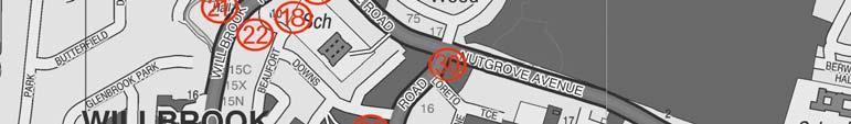


1 Rathfarnham - Walking Tour Taking in the Estate Village and Gentlemen's Seats. Rathfarnham Village and its Neighbourhood - A Guided Walk. Map:
 suggests that there was a settlement there before that time but we know nothing about the people who lived")
2 Introduction: The recorded history of Rathfarnham, insofar as we can learn from existing records, began at the time of the Anglo-Norman invasion when in 1199 these lands were granted to Milo le Bret. The name Rathfarnham (Ráth Fearnáin in Irish, the Fort of Fearnan or the Fort of the Alders) suggests that there was a settlement there before that time but we know nothing about the people who lived there. They left no remains of pre-historic burial places, no early churches and no records preserved in the annals. Getting there: Dublin Bus 15C (College Street - Whitechurch), 16 (Santry - Ballinteer), 16A (Dublin Airport - Lower Rathfarnham), 17 (Rialto - Blackrock), 75 (Dun Laoghaire - Tallaght) Rathfarnham is signposted from the M50 and N81 roads The Walk: This walk commences at the bus stop on the Rathfarnham Road, beside Rathfarnham Castle. Please use pedestrian crossings and apply the Safecross code when crossing roads. Distance: Approximately 4km Duration: The walk can be completed in 1. 5 to 2 hours. Alternatively, the walk may be shortened by only visiting the features centred on the village. From the bus stop, follow the signpost to Rathfarnham Castle (1) Formerly approached through a gothic archway from the Main Street, its great walls tower over the smaller houses in the village. This ancient fortress was erected by Adam Loftus, Protestant Archbishop of Dublin who was granted in 1583 what was then described as a waste village. His new castle was not long built when in 1600 it had to withstand an attack by the Wicklow clans and again in 1641 it was able to hold out against the Confederate army when the surrounding country was overrun. In 1649, a few days before the battle of Rathmines, the castle, which was garrisoned by the Parliamentary


3 forces, was stormed and taken by the Royalists but they probably evacuated it again when Ormonde withdrew with his army to Kilkenny. The original castle consisted of a square building four storeys high with a projecting tower at each corner, the walls of which were an average of 1.5 metres thick. On the ground level are two vaulted apartments divided by a wall nearly 3 metres thick which rises to the full height of the castle. On level with the entrance hall were the library and reception rooms and above this the former ballroom. Today, the castle is open to the public and is well worth a visit. The castle is open to visitors every day from May to October. The grounds are now a pleasant park under the care of South Dublin County Council. From Rathfarnham Castle turn right and go 250 metres until you reach a crossroads. Across the junction is seen a portion of the former entrance to Rathfarnham Castle (2) along with its gate lodge. Walk past the gate lodge and keep straight on for 600 metres until you reach the River Dodder. Following widening on the west side in 1952, the Dodder Bridge (3) was renamed Pearse Bridge in honour of Patrick and William Pearse. This bridge of one stone arch was built in The first record of a bridge on this site was in In those days, the demolition of bridges by the flood waters of the River Dodder was a common occurrence. The road from Dublin City to Rathfarnham follows the route of the ancient Slighe Chualann, the ancient highway that at the time of Saint Patrick was used by travellers from Dublin to Wicklow and Wexford. Drainage works in 1912 revealed that there was an ancient causeway here, seven metres below road level. Walk back to the crossroads. Turn to your left and follow the river for about 800 metres until you reach the junction of Dodder Road Lower. Ahead, on the left, is the Roman Arch, also known as Lord Ely s Arch (4)


. This house was occupied by the Protestant clergy during the eighteenth century.")
4 which was the original entrance to Rathfarnham Castle. The arch was built during the time of Henry Loftus, Earl of Ely between 1769 and It is named the new gate on Frizell's map of After the division of the estate in 1913 this became the entrance to the Castle Golf Club but it was later abandoned in favour of the more direct Woodside Drive. In 1841 the arch was the scene of a brutal murder, when the dead body of an Italian named Garlibardo was found lying on the open ground in front of the gate. Although arrests were made at the time no one was convicted of the murder. Return to the River Dodder and retrace your steps towards Pearse Bridge. From here, head back in the direction of Ratharnham Castle for 200 metres. The first turn to the right will take you into the Brookvale housing estate. Take this road and at the next t-juntions facing you is Ashfield House (7). This house was occupied by the Protestant clergy during the eighteenth century. In the early part of the nineteenth century it was the home of Sir William Cusack Smith, Baron of the Exchequer, and from 1841 of the Tottenham Family who continued to reside there up until After this it was occupied by the Brooks of Brooks Thomas Limited up until about 1950 when the estate was divided up and houses built along the main road. Walk back to the entrance to the estate and continue towards Rathfarnham Castle for 200 metres until you get to the junction with Rathfarnham Main Street. Rathfarnham Credit Union is on the corner. Look right and you will see the arched entrance to the graveyard (8). This graveyard contains the ruins a church which was dedicated to Saints Peter and Paul. This was a medieval church and was used for Protestant worship up until 1795 when it was too small for the congregation and a new church was built further down of

 built in 1912.")

 which is built on the site of an RIC Barracks which was blown up during the troubles in 1922.")
5 the Main Street. The end walls of the old church are still standing, the west gable containing a bell turret and the east contains a chancel arch, the chancel itself having disappeared. The north wall is gone and all that remains of the south wall is an arched opening. was converted to a courthouse. Slightly further up the Main Street on the left is the Court of Petty Sessions (9) built in The public entrance is to the left of the building while the room for the judge which was behind the bench is to the right. The Courts of Petty Sessions were forerunners of our modern day District Courts. This building served as a courthouse until the Boys' School in Willbrook Road became available when it Behind you, to the right, is the AIB Bank building (10) which is built on the site of an RIC Barracks which was blown up during the troubles in Church Lane runs between the AIB and the church. Proceed down the lane and you will see an early eighteenth century doorway (11) which is now blocked up. Continue up Church Lane to the very top for 100 metres and follow the path around. Woodview cottages (12) are on your left. The half-brick cottages are built partly on the site of an old paper mill. The mill race


6 passed under Butterfield Avenue to the paper mill and continued on below Ashfield to turn the wheel of the Ely Cloth Factory. The earliest reference to a paper mill here was in 1719 when a petition for financial aid was presented by William Lake of Rathfarnham but we hear of one at Milltown as far back as Head back through Church Lane to Rathfarnham Church of Ireland Parish Church (13) which was built in 1795 to replace the church in the old graveyard. Beside the church is the old school house which dates from the early nineteenth century. Turn right past the Court of Petty Sessions building until you reach the end of Main Street street where the road opens out at a junction. Anne Devlin s statue (14) is located just to your left. Appropriately, the statue stands looking in the direction of Butterfield Avenue. The work is by sculptor Clodagh Emoe, and was officially unveiled by Mayor Maire Ardagh of South Dublin on the 4th of March 2004, the anniversary of Robert Emmet's birth. Anne worked with Emmet in Butterfield Avenue, then known as Butterfield Lane, where he planned the 1803 Rising, and she suffered imprisonment and torture in the aftermath of its failure. The project was realised through the efforts of the citizens of the Rathfarnham area and was grant-aided by South Dublin County Council. Turn right onto Butterfield Avenue and walk for 250 metres. On your right, there s a redbrick apartment complex with car parking to the front. At the left of the

. This is another of the four 18th Century Houses on Butterfield Avenue.")

7 apartment block, obscured trees, is Butterfield House (15), which was Robert Emmet s residence before the 1803 Rising. In order to avoid being arrested before the rising took place, Emmet rented the house in April 1803 under the name of Robert Ellis and lived here with Dowdall, Hamilton and others. In charge of the housekeeping was Anne Devlin, already mentioned whose father Brian Devlin had a dairy farm nearby. At Butterfield House, cross the road. Walk for 60 metres to your left. The whitewash-finished house is Old Orchard House (16). This is another of the four 18th Century Houses on Butterfield Avenue. The name Old Orchard does not appear before 1845, previous to which there were apparently two houses named Butterfield House. It would appear, however, that in 1836 Old Orchard was named Brasvailanne, which was recorded by the O. S. that year. Walk back past the Anne Devlin statue and keep walking until you are at the set of traffic lights at a T junction. Turn right and walk for 20 metres. The Catholic Church of the Annunciation (17) is just on the corner of the road. It was built in 1878 to replace the old chapel on Willbrook Road. Outside the church door is a font (18) on a pedestal bearing the inscription "FONT USED IN MASS HOUSE OF PENAL TIMES IN PARISH OF RATHFARNHAM FROM 1732". The appearance of this font would suggest that it was originally a bullaun stone and much older than penal times.


8 Opposite the church, you can t miss the famous Yellow House (19), a pub built on the site of an inn of the same name which is marked on Taylor's map of According to tradition, in 1798 it was owned by a Michael Eades, who sheltered wanted men in his house. It was also frequented by the soldiers of the Rathfarnham Guard whose careless talk was carefully noted by the United Irishmen hiding on the premises. In 1804 when the truth came to be known, the place was wrecked by the same military. Facing the Yellow House turn left for 60 metres down Willbrook Road. On the right is the parochial house, St. Bridgets (20), where the old church stood which was replaced in This was described by the historian D 'Alton as a "cruciform edifice with galleries disproportionately low." A little further along the road, on the opposite side, you will see a pedestrian entrance to Beaufort Downs estate (22). The fine carved granite pillars here are of the former entrance to Beaufort House. At the pillars, cross the road again and head a short way up the road.


9 The former Boys School will be just on your right (21). A school first opened here in January In January 1977, St Mary's Boys' National School was opened and the building became a district courthouse until the opening of the Courthouse in Tallaght in At the same time the Court of Petty Sessions at Main Street, Rathfarnham which was operating since 1912, was closed. Walk straight up the Willbrook Road for 500 metres. Head straight past the junction with Whitechurch Road. Just on the left after The Tuning fork pub you will see a small unmarked side road. This is Willbrook Street, formerly the main street of Willbrook Village (23). It remains largely unchanged within the past hundred years. Many of the surrounding residences were built about the beginning of the 19th Century. Some small cottages at the end of the road are reminders of its once having been a rural village A short distance further up the Willbrook Road, turn right into a housing estate, Boden Wood. It has a Cul De Sac sign at its entrance. As you walk into the estate, turn to the right and Riversdale (24) is the last house on the corner. Riversdale was the last home of W. B. Yeats in Ireland. Retrace your steps back down the Willbrook Road as far as The Tuning Fork. Walk around the corner of it and there is a ruin of a mill 30


10 metres to your left. The site of the river which was its source of power is to the right. The river flows down from Kilmashogue Mountain. On the other side of the road is a partly choked up mill race which was taken from the river higher up to serve the Silveracre Mill. This was named Brooklawn Mill (25) on both Taylor s map of 1816 and on Duncan s of In 1836 Mark Flower had a pin and wire factory here which was then named Silveracres Mill. This closed down in The place was then converted into a flour mill by Robert Gibney who also owned the nearby Willbrook Mills. From 1864 to 1893 it was operated by Patrick Gibney, after which it was taken over by Mr. J. E. Madden. Subsequent to 1899 it changed hands frequently and the last tenant was Mr. Murray from 1922 to The mill has since been demolished but the Mill House and some out offices still remain. From the Mill House, keep going straight for 800 metres. Turn left at the crossroads leading to Taylor s Lane and walk for 150 metres. Follow the path into the park. Hermitage or St. Enda's (26), is at the top of the driveway. This is the former home of Padraig Pearse. The house, which is entirely faced with cut granite and has an imposing stone portico, was occupied in the eighteenth century by Edward Hudson, an eminent dentist. He had a passion for Irish antiquities which he demonstrated in an unusual way by the erection of a number of romantic ruins around the estate. The pleasant grounds and The Pearse Museum will well repay a visit. From the house go back and return to the road, Turn left for 200 metres. Turn left, and on for 150 metres. You will see a road to the right leading to a housing estate. Take this road. You will come upon an open space surrounded by a residential development. Cross the open space to the other side. What can only be described as an unassuming pile of rubble is all that remains of Priory (27), the home of John Philpot Curran, at the time of Emmet's rising. The house was formerly named Holly Park but when Curran bought it in 1790 he changed the name to Priory. Here he lived for 27 years at the peak of his fame and here he was to endure the tragic events which cast a shadow on his private

11 life. First the untimely death of his daughter Gertrude, followed by the loss of his wife, who left him for another man, and lastly the discovery of the association of his daughter Sarah with Robert Emmet. From here, return to St. Endas. Head across the field directly in front of the house towards the car park at the very end. Exit the car park. Head left at the crossroads along Barton Road West. Continue along this road for 700 metres. Loreto Abbey (27) will be on your left. It forms a landmark visible for many miles south of the city. The mansion which now forms the centrepiece of the group was built by Mr. William Palliser about No expense was spared in its construction and decoration, as can still be judged by the beautifully preserved interior, the polished mahogany and, in one room, embossed leather wallpaper. William Palliser died in 1768 without issue and Rathfarnham House passed to his cousin the Rev. John Palliser, who was rector of the parish. After his death in 1795 the house was purchased by George Grierson, the Kings Printer, who resided here for a few years. When Grierson removed to his new abode in Woodtown the house remained unoccupied for some years until in 1821 it was purchased by Most Rev.Dr. Murray for the newly founded Loreto Order. The foundress Rev. Mother Frances Mary Teresa Ball made many improvements to the place. She is said to have added a storey to the old house although there is no evidence from the exterior to support this. Many additions have been made over the years, the church was built in 1840, the novitiate in 1863 and six years later the part named St. Joseph 's wing which contains the concert hall and refectory. St. Anthony 's wing was erected in 1896, St. Francis Xavier 's in 1903 and the Lisieux building in 1932 for the accommodation of visiting prelates to the Eucharistic Congress.

12 Directly across from the mansion is Beaufort House (28) This is now the headquarters of the Loreto Order in Ireland. On the grounds is Loreto High School Beaufort which was founded in Keep walking straight past Loreto for 250 metres to a T junction. To the left and right is Nutgrove Avenue. The avenue was widened and extended in the 1960s to link up with Churchtown. The old quiet tree-shaded avenue has been completely swept away, along with the "narrow lanes" a cramped passage bounded on both sides by towering walls and full of right angled bends, which wended its crooked course between Loreto Convent cemetery and the garden of Nutgrove House. Joyce in his "Neighbourhood of Dublin" states that Nutgrove house was at one time the dower house of Rathfarnham Castle but in this he is almost certainly mistaken, as Frizell's map of 1779 shows that it was outside the estate. It is possible that he confused it with the other old house on the opposite side of the avenue which was formerly named Ely Cottage, later altered to Ely Lodge, and which was shown as within the boundary of the estate. At the T junction, take a left which will bring you past the Yellow House and towards Rathfarnham Castle where we started our walk. Rathfarnham and the surrounding area are rich in heritage and history. A guided walk such as this can only hope to give a flavour of that history and heritage. Please see and for more information or visit the Local Studies Collection at The County Library or Ballyroan Library
Rathfarnham - Walking Tour
 Rathfarnham - Walking Tour Taking in the Estate Village and Gentlemen's Seats - Rathfarnham Village and its Neighbourhood, a Guided Walk. Map: Introduction: The recorded history of Rathfarnham began at
Lissadell, Whitechurch Road, Rathfarnham, Dublin 16 On approximately 1 Acre
 Lissadell, Whitechurch Road, Rathfarnham, Dublin 16 On approximately 1 Acre Lissadell, Whitechurch Road, Rathfarnham, Dublin 16 On approximately 1 Acre A charming period residence in mature grounds that
Groby Pool and Bradgate Park. Circular walks around Leicestershire. Lin and John
 Groby Pool and Bradgate Park Bradgate House Lin and John A circular walk from Groby Pool via Anstey Village, Bradgate Park and Newtown Linford Village. Duration - 2 ½ to hours 3½ hours Distance - 9¼ kilometres
Lincoln Townscape Assessment. Boultham Park Inherited Character Area Statement
 Lincoln Townscape Assessment Boultham Park Inherited Character Area Statement January 2008 Page 2 of 12 Table of Contents Page Overview 2 Historical Development 2 Urban form 3 Views 5 Condition of Buildings
RATHFARNHAM, DUBLIN 16.
 FOR SALE BY PRIVATE TREATY RESIDENTIAL FARM C. 70 ACRES/ 28.3 HA., IN ONE OR MORE LOTS, WOODTOWN, RATHFARNHAM, DUBLIN 16. LOCATION: Situated on elevated site in the foothills of the Dublin Mountains with
After the Norman Conquest in 1066, Earl Hugh of Chester granted control of lands to his Barons. In 1119 Hamon de Macy is mentioned in records as
 After the Norman Conquest in 1066, Earl Hugh of Chester granted control of lands to his Barons. In 1119 Hamon de Macy is mentioned in records as holding lands from Dunham, to Baguley and Northenden. He
Lancaster Conservation Area Appraisal. Character Area 8. Cathedral
 Lancaster Conservation Area Appraisal Character Area 8. Cathedral March 2013 118 3.8 Character Area 8. Cathedral 3.8.1. Definition of Special Interest "This character area is distinctive for the fine group
7-9 Egerton Drive. 100 Heath Road. Chemistry Pits Field. Former Children s Home - Long Lane. Reasons for listing:
 7-9 Egerton Drive Rarity; Aesthetic value. Example of 1930s modernism which is unusual in this area. Still largely in original external condition though windows have been replaced. 100 Heath Road Age;
Stowey Sutton Parish Council. Stowey Sutton Parish Council Placemaking Plan Assets of Community Value June 2014
 Stowey Sutton Parish Council Placemaking Plan Assets of Community Value June 2014 1 2 Contents Identifying natural & built environment assets... 5 Natural & built environment asset: Lovell Mill... 7 Natural
Sandall Park, Doncaster
 Sandall Park, Doncaster History The site was marked as the Sandall Brick and Tile Works on the 1854 and 1892 OS maps. It appeared on the 1906, 1930 and 1937 1:2500 maps similarly marked but also disused.
Holidays with a religious connection The Diocese of Salisbury Day 7
 Holidays with a religious connection The Diocese of Salisbury Day 7 The exquisite church of St Peter, Stourton alas, now undergoing expensive repairs due to the greedy and selfish actions of lead thieves.
Town of Washington, New Hampshire Master Plan 2015
 OVERVIEW OF CURRENT SITUATION: Historic Background: Washington, a rural town in southwestern New Hampshire, was first settled in 1768 and was incorporated and named in honor of General George Washington
County Development Plan Consolidated Draft + Adopted Amendments August 2017 Volume 2, Chapter 22 Easky Mini-Plan
 22. Easky Mini-Plan Village profile Easky is a coastal settlement located approximately 40 km to the west of Sligo City, in a designated Rural Area In Need of Regeneration. The nearby coastline is designated
Capability Brown at Sherborne Castle
 Capability Brown at Castle Capability Brown s lake Castle Estates From 1753 Capability Brown landscaped the grounds at in two phases, creating the beautiful lake that dominates the park and later remodelling
APPENDIX 9 HERITAGE CHARACTER
 APPENDIX 9 HERITAGE CHARACTER Defining attributes and features Perth Official Plan Appendix 9 HERITAGE CHARACTER defining attributes and features This appendix includes a table describing heritage attributes
War Memorials A-Z AW.indd 1 12/04/ :06
 AtoZ war memorials War Memorials A-Z AW.indd 1 12/04/2016 16:06 Now we have reached the centenary of the First World War, and those people who were directly involved in the conflict are no longer with
Appraisal of proposed alterations to the boundary of Helmsley Conservation Area
 Appraisal of proposed alterations to the boundary of Helmsley Conservation Area Elmslac Road: Elmslac Road was constructed in the early 1950s in two or three stages by the Helmsley Rural District Council.
BORRISOKANE SETTLEMENT PLAN
 BORRISOKANE SETTLEMENT PLAN 1.0 General Introduction and Development Context Location Borrisokane is located 15km north of Nenagh on the N52. While the town is primarily residential, it acts as a market
History of Poughkeepsie. its past. And this is a disturbing trend because almost every city has something interesting about
 Joe Palaia History of Poughkeepsie When someone goes through a town, they rarely think about its historical significance or its past. And this is a disturbing trend because almost every city has something
6. Bermondsey 6.1. Bermondsey Area Vision
 6. 6.1. Area Vision 6.1.1. is: An inner-london neighbourhood characterised by modest worker ho associated with the historic Rotherhithe docks and local manufacturing industries such as biscuits, jam, vinegar
Stanwick Neighbourhood Plan
 Stanwick Neighbourhood Plan Heritage Audit Stanwick Neighbourhood Plan Steering Group August 2015 Purpose of the Heritage Audit It is a core planning principle within National Planning Policy Framework
13. London Bridge London Bridge Area Vision
 13. 13.1. Area Vision 13.1.1. is: A globally significant central London business district which is home to international business headquarters; Internationally renowned for its prominent riverfront location
HERITAGE REPORT: REASONS FOR HERITAGE DESIGNATION. 62 Union Street. Prepared By:
 L 3-1 1 Brampton Heritage Board Date: January 18, 2011 HERITAGE REPORT: REASONS FOR HERITAGE DESIGNATION 62 Union Street Prepared By: Prepared by: Antonietta Minichillo, Heritage Coordinator Planning,
Weatherman Walking. Approximate distance: 3.8 miles For this walk we ve included OS grid references should you wish to use them. Start.
 Approximate distance: 3.8 miles For this walk we ve included OS grid references should you wish to use them. 5 4 2 3 1 Start End N W E S Reproduced by permission of Ordnance Survey on behalf of HMSO. Crown
A Place of Heritage & Culture
 A Place of Heritage & Culture Dunure Castle A Place of Heritage & Culture Galloway And Southern Ayrshire Sense Of Place Toolkit: Heritage & Culture 19 A Place of Heritage & Culture Auchinleck House This
Memo. B R A Y H e r i t a g e
 6 1 3. 5 4 2. 3 3 9 3 6 1 3. 5 4 9. 6 2 3 1 c a r l @ b r a y h e r i t a g e. c o m Memo To: Jennifer Murray, Windmill Development Corporation From: Carl Bray, Bray Heritage Date: Monday, June 5, 2017
20th of April To the Chairperson and Members of the South East Area Committee
 Conservation Section, Property, Enterprise & Economic Development Department Civic Offices, Wood Quay, Dublin 8 An Rannóg Caomhantais, An Roinn Phleanála, Maoine, Fiontraíochta & Forbairt Eacnamaíochta
Municipal Inventory of Cultural Heritage Properties - St. Joseph Inventory of Designated and Potential Heritage Properties
 Municipal Inventory of Cultural Heritage Properties - St. Joseph Inventory of Designated and Potential Heritage Properties Municipality of Bluewater, Ontario (Comprised of the former Geographical Townships
2bPlanning Scheme. Appendix. Conservation - Removal of Structures. Grangegorman
 Appendix 2bPlanning Scheme Grangegorman Conservation - Removal of Structures Innovative Urban Quarter Contemporary Healthcare Facilities Modern Education Hub Accessible Public Spaces Appendix 2b: Purpose
Appendix 4 - Character Assessment and Design Code. Character Assessment
 Appendix 4 - Character Assessment and Design Code Character Assessment To gain a deeper understanding of the Parish for the Neighbourhood Plan, a Character Assessment of the parish was carried out with
Land to West of Bessel s Way, Blewbury. Contextual Analysis. fluid
 Land to West of Bessel s Way, Blewbury Contextual Analysis fluid Contents fluid - Overview - Growth pattern - Footpath & Road connections - Landscape Character - Amenities - Agriculture - Characteristic
6: 2417 Fourth Line, Sixteen Hollow, Lion Valley Park
 1. Description of Property 6: 2417 Fourth Line, Sixteen Hollow, Lion Valley Park Municipal Address 2417 Fourth Line ame (if applicable) Sixteen Hollow, Lion Valley Park Legal Description CO 1 SDS PT LOTS
CLOUGHJORDAN SETTLEMENT PLAN
 CLOUGHJORDAN SETTLEMENT PLAN 1.0 General Introduction and Development Context Location The market town of Cloughjordan lies close to the border with Offaly at the junction of the R490 and R491 Regional
Great Ayton Community Archaeology Project. White House, a brief history
 Great Ayton Community Archaeology Project White House, a brief history White House and White House Farm are situated at the crossroads of Dikes Lane and Aireyholme Lane on the outskirts of Great Ayton,
Ordnance Street 110 Plan OS Lot 413 B202; parts of Lot 412 and portion of Lot 413
 Ordnance Street 110 Plan OS Lot 413 B202; parts of Lot 412 and portion of Lot 413 110 Ordnance Street has cultural heritage value under 3 categories Physical built in 1886, it is an example of late 19
LUXURY 3 & 4 BED HOMES IN RATHFARNHAM, DUBLIN 14
 LUXURY 3 & 4 BED HOMES IN RATHFARNHAM, DUBLIN 14 LUXURY 3 & 4 BED HOMES RATHFARNHAM DUBLIN 14 This is a distinctive development of luxury homes set on the grounds that once formed part of the Loreto Abbey
SOUTH DUBLIN created 15/06/2017
 SOUTH DUBLIN created 15/06/2017 Showing 28 Dublin South Dublin Events (added before 8th June) EXHIBITION, OPEN HISTORIC PROPERTY OR HERITAGE SITE One Tower: 1,000 Years of Stories The Round Tower, Clondalkin
7.1 Area 1: Haslemere Conservation Area
 7.1 Area 1: Haslemere Conservation Area Detailed map of Haslemere Town Conservation Area as of 2006 Crown copyright and database right 2011 Ordnance Survey LA100025451 27 The Conservation Area is characterised
WANSFORD. Village Design Statement. Supplementary Planning Guidance adopted by Peterborough City Council on 22 nd August 2003
 WANSFORD Village Design Statement 2003 Supplementary Planning Guidance adopted by Peterborough City Council on 22 nd August 2003 Prospect of Wansford Bridge, St. Mary s Church and Bridge End, c.1902 Conceived,
2 The Orangery Broke Hall Park, Banks of River Orwell, Nacton, Nr Ipswich, Suffolk
 2 The Orangery Broke Hall Park, Banks of River Orwell, Nacton, Nr Ipswich, Suffolk A delightful five bedroom mews house forming part of the Georgian mansion, Broke Hall set on the banks of the River Orwell
BUILDING PLOT ADJACENT TO 21 NOTTINGHAM ROAD, BOTTESFORD LEICESTERSHIRE NG13 0AP GUIDE PRICE 120, Market Place Bingham Nottingham NG13 8AR
 11 Market Place Bingham Nottingham NG13 8AR Tel: (01949) 87 86 85 bingham@hammondpropertyservices.com BUILDING PLOT ADJACENT TO 21 NOTTINGHAM ROAD, BOTTESFORD LEICESTERSHIRE NG13 0AP Selected as the best
NATIONAL REGISTER OF HISTORIC PLACES MULTIPLE PROPERTY DOCUMENTATION FORM CONTINUATION SHEET ASSOCIATED PROPERTY TYPES
 Section F, Page 1 ASSOCIATED PROPERTY TYPES Six common property types are identified with the 48 cemeteries surveyed in the Town of Southampton. These six property types are identified as being associated
Paynes Farm Uplowman, Tiverton, Devon
 Paynes Farm Uplowman, Tiverton, Devon Paynes Farm Uplowman, Tiverton, Devon, EX16 7LY Tiverton about 5 miles Wellington about 15 miles Taunton about 19 miles Exeter about 22 miles (Distances are approximate)
Friends Meeting House, Broughton. Meeting House Lane, Little Broughton, Cockermouth, CA13 0YQ. National Grid Reference: NY
 Friends Meeting House, Broughton Meeting House Lane, Little Broughton, Cockermouth, CA13 0YQ National Grid Reference: NY 07832 31740 Statement of Significance The modest building has medium significance
Montacute House Access Statement
 Montacute House Access Statement Montacute House Montacute Somerset TA15 6XP T: 01935 823289 E: Montacute@nationaltrust.org.uk Introduction Montacute House is one of the best preserved Elizabethan mansions.
OSTERLEY PARK AND SURROUNDING AREA
 OSTERLEY PARK AND SURROUNDING AREA Boundary: See Map 13 Date of Designation: 19 April 1988 Date of Extension: None Additional protection to the area: Osterley Park House listed grade l; with subsidiary
Archaeologia Cantiana Vol
 Archaeologia Cantiana Vol. 70 1956 FURTHER BEE BOLES IN KENT By V. F. DESBOROTTGH THE request to members, which appeared in the Paper on Bee Boles and Beehouses in Arch. Cant., LXIX, 90,1955, to report
Character Area Summary 6: Canal Zone Stonehouse Town Character Assessment, Bridgend Works from Downton Road
 Character Area Summary 6: Canal Zone An open area, with residential and industrial areas, which has a rural character and a rich historic and natural environment strongly influenced by the Stroudwater
Turning Back The Hands Of Time On Rose Hill Plantation
 Turning Back The Hands Of Time On Rose Hill Plantation A look at the remarkable post Civil War restoration of this architectural masterpiece in Bluffton, South Carolina By Mary and Hugh Williamson The
FIRST COCONUT GROVE SCHOOLHOUSE
 FIRST COCONUT GROVE SCHOOLHOUSE 3429 DEVON ROAD Designation Report City of Miami REPORT OF THE CITY OF MIAMI PLANNING DEPARTMENT TO THE HERITAGE CONSERVATION BOARD ON THE POTENTIAL DESIGNATION OF THE FIRST
'Passed to. the future
 'Passed to the future Introduction Welcome to our new national headquarters and our new brand. The move and our change of brand mark a new stage in the development and history of the Heritage Council.
Deco Discoveries: Deco for the priests in Brittany By Clive Foss
 PAGE 28 TRANS-LUX VOLUME 29 NO. 1 Deco Discoveries: Deco for the priests in Brittany By Clive Foss Brittany, in the far west of France, has many attractions for the tourist: a varied landscape, rugged
The Great Western Railway was created by an Act of Parliament on 31st August 1835 to provide a line from Paddington to Bristol.
 The Golborne Road Railway Bridge is a powerful and distinct reminder of the forward progress of mixing and the movement of populations in all its guises. It relates directly to the coming together of people
Telephone:
 I do I do FOR FURTHER INFORMATION ON HOSTING YOUR WEDDING AT NO.6 AND HOW WE CAN MAKE YOUR SPECIAL DAY MEMORABLE PLEASE CONTACT: Telephone: +353 1 669 8800 Email: events@numbersix.ie www.numbersix.ie I
Proposed Illustrative Masterplan Cumulative Revised Proposals. Properties
 Proposed Illustrative Masterplan Cumulative Revised Proposals Earls Court Project Application 2 Royal Borough of Kensington & Chelsea Environmental Statement, Volume II - Site Wide Development Option -
Saving a Course. Harold Brown, Ph.D. Philosophy and Religious Studies, NY Adelia Williams, Ph.D. English and Modern Language Studies, PLV
 Saving a Course Harold Brown, Ph.D. Philosophy and Religious Studies, NY Adelia Williams, Ph.D. English and Modern Language Studies, PLV Paris Geography When people talk about where in Paris something
UPPER GORDON ROAD TO CHURCH HILL, CAMBERLEY CONSERVATION AREA
 Introduction This leaflet explains the purpose of conservation areas and the implication of their designation for residents, property owners and the Council. It provides you with a plan of the area and
Welcome to our public exhibition
 About Our Scheme Welcome to our public exhibition This exhibition gives you the chance to view and comment upon our emerging proposals for a new residential development of 68 new homes on the site of the
POUND COTTAGE STREAM ROAD F UPTON F OXFORDSHIRE.
 POUND COTTAGE STREAM ROAD F UPTON F OXFORDSHIRE www.warmingham.com POUND COTTAGE STREAM ROAD F UPTON F OXFORDSHIRE Didcot 2 ½ miles (London Paddington 40 minutes) F M4 (Junction 13) 6 miles F Newbury
Sissinghurst Walk. 10 miles (16 kms) allow 5 hours
 allow 5 hours") Sissinghurst Walk 10 miles (16 kms) allow 5 hours A Walk T h rough Time Sissinghurst Walk distance 10miles (16 kms) allow 5 hours This route takes the walker northwards from Cranbrook through woods, past
Sissinghurst Walk 10 miles (16 kms) allow 5 hours A Walk T h rough Time Sissinghurst Walk distance 10miles (16 kms) allow 5 hours This route takes the walker northwards from Cranbrook through woods, past
FROM ARC DE TRIOMPHE TO CHAMP-DE-MARS
 FROM ARC DE TRIOMPHE TO CHAMP-DE-MARS THE TOUR : THE ARC DE TRIOMPHE, THE TROCADERO, THE EIFFEL TOWER, THE CHAMP DE MARS THE ARC DE TRIOMPHE THE TROCADÉRO THE EIFFEL TOWER THE CHAMP-DE-MARS Length : -
Character Area 6. Canal Corridor: South
 Character Area 6. Canal Corridor: South March 2013 98 3.6 Character Area 6. Canal Corridor South 3.6.1. Definition of Special Interest "The character of this area is defined by a group of large, significant
Blakemoorgate. Snailbeach and Blakemoorgate
 Blakemoorgate The remains of two miners cottages at Blakemoorgate at the northern end of the Stiperstones are being renovated by Natural England. Even before restoration is complete they already provide
TOLLYMORE PARK A GUIDE TO THE FOLLIES & GARDEN BUILDINGS
 TOLLYMORE PARK A GUIDE TO THE FOLLIES & GARDEN BUILDINGS Tollymore Park by James Howley This guide shows how the follies and garden buildings in Tollymore Park inter-relate with each other and the landscape
SUSTAINABLE URBAN DEVELOPMENT INVESTMENT PROGRAM FOUR YEARS OF PROGRESS
 SUSTAINABLE URBAN DEVELOPMENT INVESTMENT PROGRAM FOUR YEARS OF PROGRESS Yerevan is the economic, scientific and cultural center of the Republic of Armenia. It is considered as the major regional transportation
The Villages. Dudley House Godmersham. local village property
 Dudley House Godmersham www.hobbsparker.co.uk Dudley House The Street Godmersham, Kent CT4 7DU A handsome semi-detached period house with good size living accommodation and attractive rear garden (approximately
Nailsea and District Local History Society
 YOUNGWOOD LANE, NAILSEA AN HISTORIC LANDSCAPE BY MARGARET THOMAS Coombe Grange Previously published June1996 by Nailsea & District Local History Society This ebook version, Margaret Thomas and Nailsea
CA1: PART 1: Section 3.0 to 3.4
 3.0 THE PARK CONSERVATION AREA 3.1 Location & Setting The Park Conservation Area stands at the north-west edge of Cirencester town centre and to the west of the remaining three conservation areas in the
Opposite: Georgius Hoefnagle s plan of Brightstowe (1581) (Bristol s Museums, Galleries and Archives).
 (Bristol s Museums, Galleries and Archives).") Mapping the City The earliest-known representation of Bristol in map-form is found in Robert Ricart s The Maire of Bristowe is Kalendar (1480-1508), the first detailed chronicle to have been produced of
Mapping the City The earliest-known representation of Bristol in map-form is found in Robert Ricart s The Maire of Bristowe is Kalendar (1480-1508), the first detailed chronicle to have been produced of
Centennial Reflections Essays from the Oakwood Historical Society
 Centennial Reflections Essays from the Oakwood Historical Society Oakwood is home to 10 different Parks By Harry G. Ebeling Parks maybe not a big item in your life or maybe one of the main reasons you
Shakespeare s Quest at Leeds Castle
 Shakespeare s Quest at Leeds Castle This book belongs to: leeds-castle.com Welcome to Leeds Castle Listed in the Domesday Book of 1086 as a Saxon manor, Leeds Castle has played many roles since then. It
Dulwich Dulwich Area Vision Map
 Area Vision Map Greendale Playing Fields East Lordship Lane Peckham Rye Park Herne Hill North St Barnabas Church Friern Road Edward Alleyn Club Herne Hill Velodrome Picture Gallery Village/College Road
L 4-1. Heritage Report: Reasons for Heritage Designation. Kodors House. 35 Rosedale Avenue West
 L 4-1 Brampton Heritage Board Date: January 17, 2012 Heritage Report: Reasons for Heritage Designation Kodors House 35 Rosedale Avenue West December 2011 1 L 4-2 Profile of Subject Property Municipal Address
Historical Value As evidence of Quaker heritage in Wells extending over three hundred years, the meeting house has high historical value.
 Friends Meeting House, Wells-next-the-Sea Quaker Yard, Church Street, Wells-next-the-Sea, Norfolk, NR23 1HZ National Grid Reference: TF 91978 43092 Statement of Significance The building has high significance
2 St Mary s Avenue, Rathfarnham, Dublin 14.
 2 St Mary s Avenue, Rathfarnham, Dublin 14 www.huntersestateagent.ie For Sale by Private Treaty Hunters Estate Agent is delighted to launch to the market this lovely two storey, three bedroom house in
Cathedrals. Cathedrals means chair and was the seat of the local bishop Cathedrals were built to take the worshipper to heaven.
 Cathedrals Cathedrals Cathedrals means chair and was the seat of the local bishop Cathedrals were built to take the worshipper to heaven. The Gothic period lasted from the late 1100's to the 1500's. Most
CHESHIRE HISTORIC TOWNS SURVEY
 CHESHIRE HISTORIC TOWNS SURVEY Frodsham Archaeological Strategy 2003 CHESHIRE HISTORIC TOWNS SURVEY Frodsham Archaeological Strategy 2003 Environmental Planning Cheshire County Council Backford Hall Backford
The Supreme Court of the United Kingdom. Hospitality
 The Supreme Court of the United Kingdom Hospitality Situated at the heart of historic Parliament Square, the home of the Supreme Court of the United Kingdom offers a unique experience... An introduction
The Mill House Isfield, East Sussex
 The Mill House Isfield, East Sussex An impressive and well-appointed Grade II listed country house set in beautiful grounds of 4.904 acres, with a cottage, tennis court, swimming pool and Sussex Barn.
HIGH WALL COTTAGE STREATLEY ON THAMES F BERKSHIRE.
 HIGH WALL COTTAGE STREATLEY ON THAMES F BERKSHIRE www.warmingham.com HIGH WALL COTTAGE STREATLEY ON THAMES F BERKSHIRE F Goring & Streatley Station 0.6 miles F Pangbourne 5 miles F Wallingford 6 miles
Exploring the Architecture of Historical Downtown Halifax
 Exploring the Architecture of Historical Downtown Halifax Our Collections A Grassroots Block project March 2000. Joyce Boudreau (co-ordinator), Robert Bray,Linda Landry, Jean McGuire, Lorna Randall, Lynne
Within an Area of Outstanding Natural Beauty, a charming former coach house to Bolebrook Castle set within extensive grounds including ancient
 Bolebrook Wood Farm Within an Area of Outstanding Natural Beauty, a charming former coach house to Bolebrook Castle set within extensive grounds including ancient woodland, paddocks, stabling, barns and
Demolition of a Designated Heritage Property Roncesvalles Avenue
 REPORT FOR ACTION Demolition of a Designated Heritage Property - 421 Roncesvalles Avenue Date: March 8, 2018 To: Toronto Preservation Board Toronto and East York Community Council From: Acting Chief Planner
Scheduled Monument (SM90020); Listed Building (LB551 Category A) Taken into State care: 2006 (Ownership) Last reviewed: 2004
; Listed Building (LB551 Category A) Taken into State care: 2006 (Ownership) Last reviewed: 2004") Property in Care(PIC) ID: PIC326 Designations: Scheduled Monument (SM90020); Listed Building (LB551 Category A) Taken into State care: 2006 (Ownership) Last reviewed: 2004 HISTORIC ENVIRONMENT SCOTLAND
Property in Care(PIC) ID: PIC326 Designations: Scheduled Monument (SM90020); Listed Building (LB551 Category A) Taken into State care: 2006 (Ownership) Last reviewed: 2004 HISTORIC ENVIRONMENT SCOTLAND
University College Dublin NEWMAN HOUSE
 University College Dublin NEWMAN HOUSE What has better claim to the purest and fairest possessions of nature than the seat of wisdom JOHN HENRY NEWMAN INTRODUCTION A most historic venue, University College
Toronto and East York Community Council Item TE34.30, as adopted by City of Toronto Council on August 25, 26, 27 and 28, 2014 CITY OF TORONTO
 Authority: Toronto and East York Community Council Item TE34.30, as adopted by City of Toronto Council on August 25, 26, 27 and 28, 2014 CITY OF TORONTO BY-LAW 1393-2017 To designate the property at 481
Contact details Lacock Abbey, Lacock, Chippenham, SN152LG T: E:
 Lacock Abbey, Fox Talbot Museum, Grounds, Café and High street shop Access Statement The estate of Lacock Abbey, located at the heart of Lacock village within its own woodland grounds, is a quirky country
Honeysuckle Cottage, Worles Common, Pensax, Worcestershire.
 Honeysuckle Cottage, Worles Common, Pensax, Worcestershire. Honeysuckle Cottage, Worles Common, Pensax, Worcestershire WR6 6XQ A charming detached country cottage with views towards Abberley Clock Tower.
Rushmere Lodge, Beauty Bank, Whitegate, Northwich, Cheshire CW8 2BP.
 Rushmere Lodge, Beauty Bank, Whitegate, Northwich, Cheshire CW8 2BP www.srushton.co.uk An extended and extensively refurbished thatched country house with large indoor swimming pool complex, standing in
Asset and Responsibility Register
 and Responsibility Register UFFORD PARISH COUNCIL Judi Hallett CLERK, UFFORD PARISH COUNCIL Page 0 FINAL September 2018 Contents 1. Introduction... 2 2. s... 3 Bus Shelters... 3 Seats... 3 Dog Bins...
Historic England Advice Report 26 August 2016
 Case Name: Kingsland Castle Case Number: 1435892 Background Historic England has been asked to review the scheduling for Kingsland Castle. The land on which the monument lies is understood to be for sale.
England and Wales 7 nights Linking England with Wales: a tour with varieties of landscapes, culture and experiences
 England and Wales 7 nights Linking England with Wales: a tour with varieties of landscapes, culture and experiences Snowdonia National Park 1 Day 1. Meet and great London Heathrow, Stonehenge and Bath
Built in 1984, the meeting house is the third meeting house on a site acquired in 1668 as a burial ground. The building has low heritage significance.
 Friends Meeting House, Reigate 47 Reigate Road, Reigate, Surrey, RH2 0QT National Grid Reference: TQ 26184 50219 Statement of Significance Built in 1984, the meeting house is the third meeting house on
East Riding Historic Designed Landscapes. Report by David and Susan Neave February 2013
 YORKSHIRE GARDENS TRUST East Riding Historic Designed Landscapes GRIMSTON GARTH Report by David and Susan Neave February 2013 1. CORE DATA 1.1 Name of site: Grimston Garth, East Garton 1.2 Grid reference:
London Bridge London Bridge Area Vision Map
 Area Vision Map Borough Market Southwark Cathedral NSP54 Hay s Galleria Key: NSP Site Allocations Greenspace Low Line Thames Path Cycle Network Primary Shopping Areas Borough High Street Tube Station NSP51
History of the Cranley Road Area. What is The Cranley Road Area
 History of the Cranley Road Area. What is The Cranley Road Area The Cranley Road Area lies to the east of Guildford. It was originally developed as large Victorian villas by the 4 th Earl of Onslow. It
Activity Description. New York Mini Stay. Head straight to the Castle Clinton National Monument (circular fort).
.") Activity Description New York Mini Stay Downtown NYC Tour When you get off the ferry, you are in Battery Park. Stop #1: Battery Park Battery Park is a public park named for the artillery batteries that
Activity Description New York Mini Stay Downtown NYC Tour When you get off the ferry, you are in Battery Park. Stop #1: Battery Park Battery Park is a public park named for the artillery batteries that
Former Temple Cowley Pools, Oxford TEMPLE COWLEY LIBRARY * ELEVATION SHOWN IS INDICATIVE AND SUBJECT TO FINAL DESIGN AND AGREEMENT.
 OPEN SPACE TEMPLE COWLEY LIBRARY library beyond Proposed apartments Proposed apartments Proposed houses Temple Road * ELEVATION SHOWN IS INDICATIVE AND SUBJECT TO FINAL DESIGN AND AGREEMENT. * Welcome
The Best Luxury of All
 The Best Luxury of All Look what those enormously wealthy Victorians, who could afford anything they wanted, spent their money on! They built greenhouses and then went to even more expense heating and
30. Riverstown Mini-Plan
 County Development Plan 2017-2023 Consolidated Draft + Adopted Amendments August 2017 Volume 2, Chapter 30 Riverstown Mini-Plan 30. Riverstown Mini-Plan Village profile Riverstown is located approximately