PIPELINE ROAD DESIGN PROJECT COMMUNITY INFORMATION SESSION
|
|
|
- Valerie Watts
- 5 years ago
- Views:
Transcription

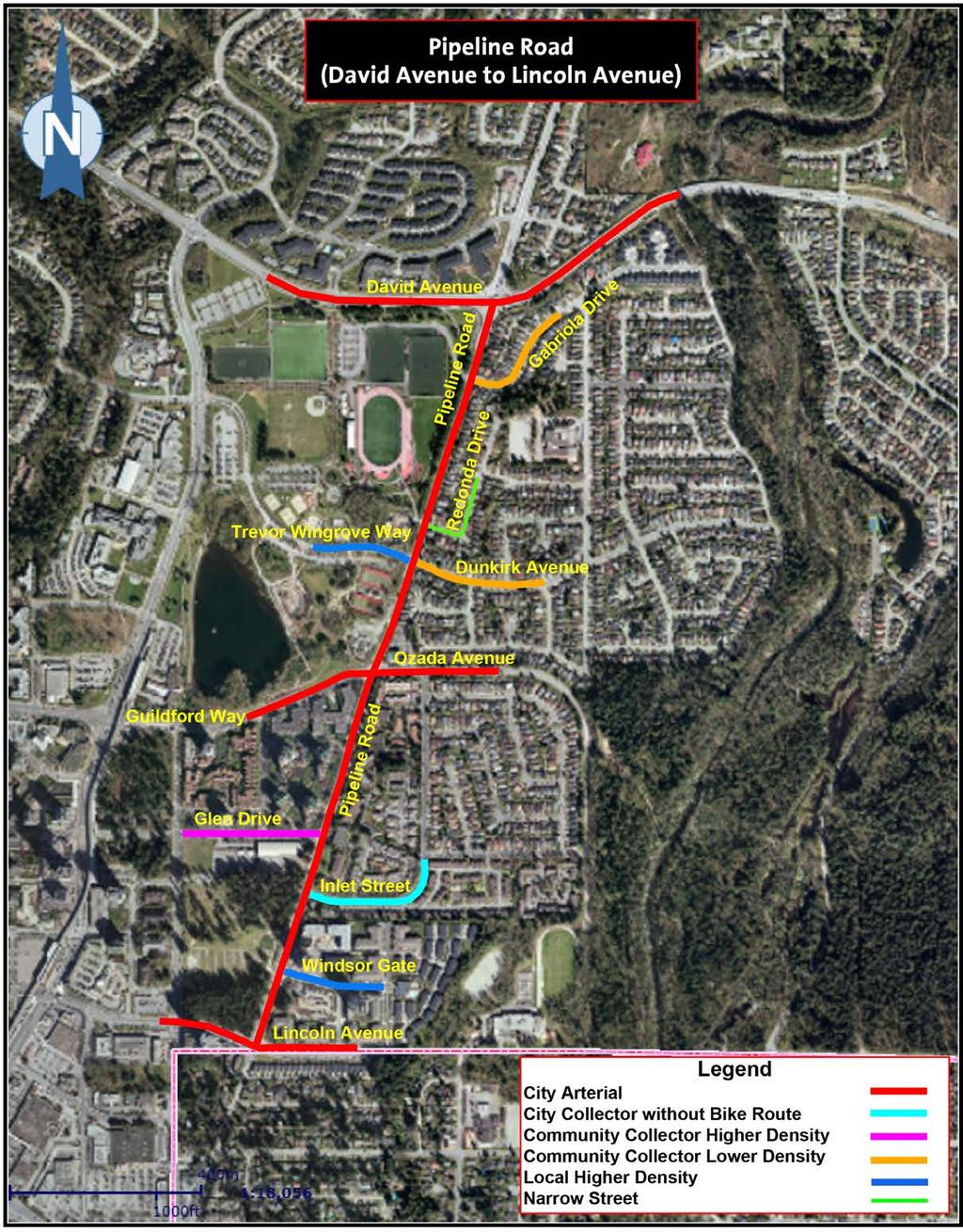
1 Dunkirk Avenue COMPLETING THE STREET Coquitlam is initiating the design to complete Pipeline Road between Guildford Way and David Avenue. This arterial road serves the Town Centre and Northeast Coquitlam. This community information session is an opportunity to comment on the design considerations for completing the street. David Avenue Pipeline Road Guildford Way Project Extent FEEDBACK Your feedback is important to us Please take a moment to provide us with your comments.

2 TIMELINE Design Process Open House 1 Design Considerations May 24 & 27, 2017 WE ARE HERE Open House 2 Street Options and Evaluation Criteria Fall 2017 Open House 3 Preferred Design Winter 2018 Detailed Design to follow once a preferred option is selected. Phasing of construction will be determined once the design process is complete.

3 GUIDING PRINCIPLES Project Goals and Considerations: Complete the street to better serve all users Support existing development and future growth Enhance mobility for area residents Support the Town Centre Park Master Plan Design a cost effective street Support the arterial street role as a primary mobility route Balance environmental impacts, available space and community needs Provide on-street parking during offpeak hours where feasible Benefits: Improved operations and safety for all users Improved aesthetics and lighting Enhanced pedestrian facilities Enhanced gateway to Town Centre Park
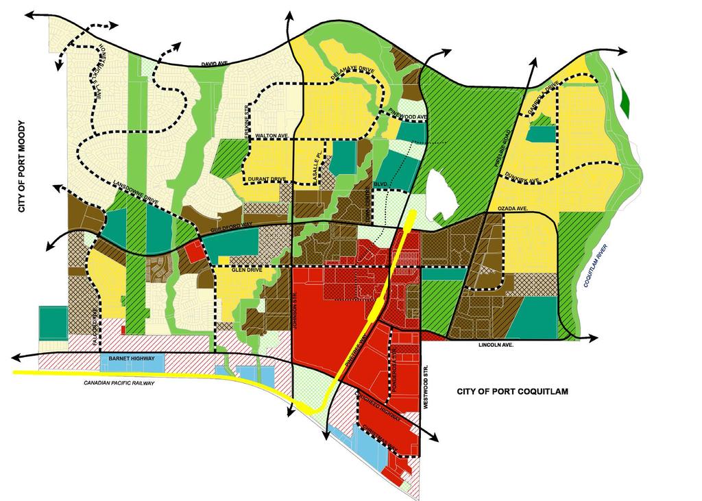

4 PLANNING CONSIDERATIONS FOR THE AREA Land Use Plan for City Centre Road Network Plan for City Centre
5 Ozada Daimler St Franklin St Sherman St Jordan St The High St Ozada Ave Esperanza Dr Wise Crt Nestor St Graham St Hornby St PLANNING CONSIDERATIONS FOR THE AREA Harper Harper ² Cycling Connections Dayton Robson Coast Meridian Princeton Soball New Street Pipeline Road is a Pinewood Park Pathway David Oxford David Burke Village Promenade Rocklin designated cycling route. Lansdowne Glen Johnson Walton Pacific Guildford Pinetree Town Centre Park Pipeline Shaughnessy Soball LEGEND Victoria Gislason Cycling Routes by Type Cycling Routes by Type and Status Shared Bikeway, Existing It connects to David Avenue multi-use path, Trevor Wingrove Way and Barnet Aberdeen Mariner Overpass Lincoln Shared Bikeway, Proposed Bike Lane, Existing Bike Lane, Proposed MUP, Existing MUP, Proposed Guildford Way cycling routes. Dewdney Trunk Saddle Pathway Lougheed Parks and Natural Areas Coquitlam ,320 1,760 Metres Transit Service TransLink s 2017 transit routes & new # 189 route #189 is the only route currently traveling along Pipeline Road within the project. 30 min frequency except during evenings. #186, #188, #191 routes serve David Avenue at Pipeline Road. Johnson St Johnson St Michigan Dr Corbin Pl Delahaye Dr Durant Dr Lasalle Pl Cord Ave Walton Ave Pacific St Cimarron Dr Albion Dr Burlington Dr Town Centre Blvd Guildford Way "Ã Pinewood Ave David Ave "Ã Heffley Cres Pinetree Way Pinetree Way Westwood St Westwood St Glen Dr Silver Springs Blvd 189 Coquitlam Central Station/ Lafarge Park December 2016 For route and schedule information, visit CMBC Service Planning 100 Meters David Ave Delahaye Dr Johnson Crt Lancia Pl Legend (!T (!S Å West Lotus Crt Regular Routing West Coast Express Princess Cres Julian Ave Route Terminus/Scheduled Stop Coast Express Station Coquitlam Centre White Pine Pl Lafarge Lake - Douglas City Hall Lincoln Ùo Primrose Lane Lincoln Ave Eastwood St Town Centre Park Pathan Ave Pipeline Rd Ozada Ave Inlet St Texada St Redonda Dr Bowen Dr Sechelt Dr Bute Cres Toba Dr unsigned Gambier Ave Secret Crt Shelter Cres Galiano St Tahsis Ave El Camino Dr Caliente Pl Gabriola Dr Harwood Ave Dunkirk Ave Cortes Ave Gabriola 189 Coquitlam Central Station Reid Crt Chrome Cres Savary Ave Salt Spring Ave Ballenas Crt Georgeson Ave (!S Mayne Cres Gabriola Dr David Ave Samuels Crt Lincoln Ave Barnet Hwy "Ã Å (!T Coquitlam Central Coquitlam Central Station Pheasant St Pinetree Way Pinetree Village Anson Ave Coquitlam Central Station Bay 2: 189 Lafarge Park Christmas Way Ponderosa St Crabbe Ave Lougheed Hwy Redwood Ave Woodland Dr Murchie Pl Lancaster St Larkin Ave Tuohey Ave Clayton St Kitchener Ave Raleigh St Gail Ave Jervis St Patricia Ave Greer Pl McRae Cres Hastings Pl Sawyer Pl Hastings St Stevenson St Friskie Ave Glenwood Ave Chilcott Ave Hughes Pl Scott Pl Carlisle St Kitchener Ave Lafleur St Shaughnessy St Chester Pl Laurier Ave Dorset Ave Salisbury Ave Glasgow St Dewdney Trunk Rd Norman Ave Lougheed Hwy Hoy St Bouthot Crt Fleming Ave Gordon Ave Fox St Shaftsbury Ave Raleigh St Battistoni Pl Shaftsbury Pl Osborne St Ogilvie Cres Prairie Ave Prairie Ave


6 EXISTING CONDITIONS The majority of the street improvements are expected to be on the west side of Pipeline Road. Existing features include: GAPS IN SIDEWALK TREES WITHIN EXISTING ROAD RIGHT-OF-WAY POWER POLES AND OVERHEAD UTILITIES ROADSIDE WATERCOURSE

7 Dunkirk Avenue BIGGER PICTURE CONSIDERATIONS GROWTH: As a result of land development and growth in Northeast Coquitlam, arterial traffic volumes will increase in built-out conditions as shown below. Estimated Two Way Traffic Volumes along Pipeline Road Now 13,000 15,000 BUILD-OUT* 20,000 + *Estimate, dependant on actual land development build out. Source: Traffic Counts and estimates by the City of Coquitlam FUNDING: To address this growth, the City collects Development Cost Charges from each new development to fund required infrastructure improvements. The Development Cost Charges will be used to pay for the upgrade of Pipeline Road. David Avenue Pipeline Road

8 KEY ELEMENTS Typical features of an upgraded arterial street are: Continuous Sidewalk along both sides of the street Improved lighting conditions Appropriate capacity to address existing and future transportation and mobility needs Appropriate storm water management to protect stream health Improved intersections and street crossings Cycling connectivity within road right-of-way or through the park Provision for bus stops Landscape treatments
9 FEEDBACK CONSIDERATIONS & OPPORTUNITIES The design will take into account existing conditions and opportunities identified through this process: What existing street conditions should we be aware of during the design process? Some of these are already shown in the adjacent map. What are the opportunities for future improvements that you would like to see in the design? Please identify additional considerations and opportunities along Pipeline Road. Your feedback will be considered in developing design options for the street. THANK YOU FOR YOUR PARTICIPATION! If you are unable to provide comments during this Open House, an online questionnaire is available for you until June 7 at. STAY INFORMED Visit and sign up to receive project updates by .
Town Centre Park. Delahaye. David Avenue. Pine wood. Pipeline Rd. Pinetree. Town Ctr Blvd. Guildford. Guildford. High St. Westwood. Pinetree.
 WELCOME This open house is to give you an opportunity to review the proposed design of an outdoor performance and events plaza at Town Centre ark and to share your ideas, suggestions and thoughts related
Transit-Oriented Development Strategy. A Community Building Opportunity
 Transit-Oriented Development Strategy A Community Building Opportunity July 30, 2012 Coquitlam Transit-Oriented Development Strategy (TDS) Approved by Council Resolution July 30, 2012. CARRIED UNANIMOUSLY.
2040 Long Range Transportation Plan
 2040 Long Range Transportation Plan Adopted: April 15, 2013 APPENDIX D HIGHWAY NEEDS PLAN PROJECTS FREDERICKSBURG Existing and Committed Projects Fall Hill Avenue/Mary Washington Blvd. (Fredericksburg)
Evergreen Line Rapid Transit Project
 Evergreen Line Rapid Transit Project Station Area Design Consultation Discussion Guide October 4 November 5, 2010 www.evergreenline.gov.bc.ca FEEDBACK FORM INSIDE We Want To Hear From You Consultation
Gratigny Parkway East Extension Project Development & Environment (PD&E) Study
 Study") Gratigny Parkway East Extension Project Development & Environment (PD&E) Study Session 4: Presentation of Charrette Results December 8, 2010 MDX Work Program #: 92407 ETDM#: 11500 Project Location & Description
Gratigny Parkway East Extension Project Development & Environment (PD&E) Study Session 4: Presentation of Charrette Results December 8, 2010 MDX Work Program #: 92407 ETDM#: 11500 Project Location & Description
Executive Summary. NY 7 / NY 2 Corridor
 Executive Summary NY 7 / NY 2 Corridor Transportation and Land Use Study December 2005 Prepared for: Town of Colonie Capital District Transportation Committee Prepared by: Introduction: Land use decisions
Old Town Neighborhoods Plan. Choices Event Wednesday, December 9, 2015
 Old Town Neighborhoods Plan Choices Event Wednesday, December 9, 2015 Agenda 6:00 6:10 p.m. Welcome + Sign In 6:10 6:30 p.m. Presentation 6:30 8:00 p.m. Workshop + Open House Seeking your input on: Neighborhood
IOWA HIGHWAY 57 / WEST 1 ST STREET STUDY PUBLIC INFORMATIONAL MEETING APRIL 22, 2014
 IOWA HIGHWAY 57 / WEST 1 ST STREET STUDY PUBLIC INFORMATIONAL MEETING APRIL 22, 2014 INTRODUCTION The City of Cedar Falls and the Iowa Department of Transportation are conducting a Public Informational
South Davis County COMMUNITY SPOTLIGHT
 South Davis County COMMUNITY SPOTLIGHT Davis/SLC Community Connector Bus Rapid Transit line connecting SLC & Davis County RTP Phase 1 Project Generate 3,100 average weekday riders Relieve congestion on
Lambeth Community Improvement Plan Workbook
 Lambeth Community Improvement Plan Workbook Community Information Meeting #3 March 28, 2017 Contents ii Meeting Overview 1 CIP Background 2 Project Timeline 3 Contact Information 4 Project Area 6 Vision
City of Coquitlam Parkland Management Framework
 City of Coquitlam land Management Framework Coquitlam s land Management Framework The City of Coquitlam currently manages approximately 955 hectares (2,359 acres) of parkland that s about double the size
Borderland Expressway Coalition Status Report Camino Real RMA Board Meeting. El Paso, TX April 11, 2018
 Borderland Expressway Coalition Status Report Camino Real RMA Board Meeting El Paso, TX April 11, 2018 Coalition Key Stakeholders Texas Department of Transportation New Mexico Department of Transportation
REVIEW AND EVALUATION OF REGIONAL LAND USE
 REVIEW AND EVALUATION OF REGIONAL LAND USE AND TRANSPORTATION SCENARIOS #220831 Environmental Justice Task Force October 7, 2014 VISION 2050 Process Development of Guiding Vision for Land Use and Transportation
Welcome. Northern Segment of Hwy 100 I-90 to South of Madison Street Meeting Goals:
 Welcome Northern Segment of Hwy 100 I-90 to South of Madison Street Meeting Goals: - Review Environmental Assessment - Share Preferred Alternative -Receive Public Comments 2003 EA Preferred Alternative
Mount Dennis Mobility Hub Study Public Meeting December 12 th, :30pm 9:30pm York Memorial Collegiate, Cafeteria 2690 Eglinton Avenue West
 Mount Dennis Mobility Hub Study Public Meeting December 12 th, 2012 6:30pm 9:30pm York Memorial Collegiate, Cafeteria 2690 Eglinton Avenue West MEETING SUMMARY On December 12 th, 2012, over 89 people participated
Moody Centre Station TOD Area Today
 Moody Centre Station TOD Area Today WHAT IS a transit-oriented Murray Street development area? A Transit-Oriented Development (TOD) Area is a dense, walkable residential and commercial area built to support
4-Town Comprehensive Plan DRAFT 7/30/07
 4-Town Comprehensive Plan DRAFT 7/30/07 Acknowledgements ning Committee Town of Harrisburg Norman Roof Randy Nicol Town of Martinsburg Terry Thisse Paul Kelly Town of Montague Jan Bagdanowicz Wendy Perry
WELCOME 50 street cp rail grade separation + road widening. public information session #1 June 26, pm to 8 pm
 WELCOME 50 street cp rail grade separation + road widening public information session #1 June 26, 2018 5 pm to 8 pm session purpose To provide residents, businesses, and users of 50 Street with the opportunity
Glenborough at Easton Land Use Master Plan
 Vision Statement Sunrise Blvd. Hazel Ave. Prairie City Rd. Gencorp Property Lincoln Regional Airport 1.0 VISION STATEMENT The identifies City of the principles, goals, policies, and standards Lincoln that
This Review Is Divided Into Two Phases:
 Semiahmoo Town Centre Review The purpose of this review: To review the Semiahmoo Town Centre Concept Plan, originally approved in 1993, to ensure that this centre will continue to serve the needs of South
Adam R. Lid Addendum to Proposed Amendments List for Mobility Plan 2035
 shjss Date: Submitted incommits Council Fite No: ^ item No.' L Deputy Adam R. Lid Addendum to Proposed Amendments List for Mobility Plan 2035 CF15-0719 August 4, 2015 L City Hall 200 N. Spring Street,
Cottage Grove Road Reconstruction. City of Madison Engineering
 Public Informational Meeting Cottage Grove Road Reconstruction October 8, 2015 Presentation Outline Introduction Project Purpose & Need Proposed Design Overview Environmental Concerns Pedestrian Needs
FDOT D4 Complete Streets
 FDOT D4 Complete Streets Context Sensitive Solutions Directs that complete street solutions will complement the context of the community. Collaborative approach to decision making, project development,
South Corridor Rapid Transit Project Public Kick-Off Meeting
 Department of Transportation and Public Works (DTPW) South Corridor Rapid Transit Project Public Kick-Off Meeting Wednesday, May 31, 2017 Please use same 4 pictures from Fact Sheet 1 Meeting Overview Miami-Dade
Engineering & Development Services Completed Projects, (Excluding Development Projects)
") Engineering & Development Services Completed Projects, 2006 2009 (Excluding Development Projects) 2009- up to end of June The reconstruction of Centre St. and McFarland Ave. was completed. The Bell Blvd.
Engineering & Development Services Completed Projects, 2006 2009 (Excluding Development Projects) 2009- up to end of June The reconstruction of Centre St. and McFarland Ave. was completed. The Bell Blvd.
CITY OF LOS ANGELES INTER-DEPARTMENTAL CORRESPONDENCE
 CITY OF LOS ANGELES INTER-DEPARTMENTAL CORRESPONDENCE 20000 Prairie St. DOT Case No. 41443 Date: November 5, 2014 To: R. Nicolas Brown, Associate Zoning Administrator Department of City Planning From:
St. Clair Avenue West Area Transportation Master Plan
 1 (Between Keele Street and Old Weston Road) Public Information Centre 1 December 2, 2015 2 Welcome Welcome to the first Public Information Centre for the St. Clair Avenue West Area. The panels will present
SOUTHWEST TRANSITWAY (STAGE 2) PUBLIC OPEN HOUSE
 PUBLIC OPEN HOUSE") WELCOME! SOUTHWEST TRANSITWAY (STAGE 2) PUBLIC OPEN HOUSE Monday, November 18, 2013 3:30 to 5:30PM and 7:00 to 9:00PM Tuesday, November 19, 2013 3:30 to 5:30PM and 7:00 to 9:00PM Welcome to the Southwest
WELCOME! SOUTHWEST TRANSITWAY (STAGE 2) PUBLIC OPEN HOUSE Monday, November 18, 2013 3:30 to 5:30PM and 7:00 to 9:00PM Tuesday, November 19, 2013 3:30 to 5:30PM and 7:00 to 9:00PM Welcome to the Southwest
Prince William Street Project (Grant Avenue to Wellington Road)
") Prince William Street Project (Grant Avenue to Wellington Road) 1 Goals Improve pedestrian and bike traffic safety Improve street drainage with curb & gutter Upsize water mains Enhance overall street appearance
Prince William Street Project (Grant Avenue to Wellington Road) 1 Goals Improve pedestrian and bike traffic safety Improve street drainage with curb & gutter Upsize water mains Enhance overall street appearance
Northeast Streets - Completion of Functional Design Process
 Coouitlam For Council January 14, 2014 Our File: 16-8690-06/000/2013-1 Doc#: 1595055.V3 To: From: Subject: For: City Manager General Manager, Engineering and Public Works Northeast Streets - Completion
BOISE, IDAHO COUNCIL WORK SESSION AGENDA September 19, :00 PM City Hall - Council Chambers
 BOISE, IDAHO COUNCIL WORK SESSION AGENDA September 19, 2017 5:00 PM City Hall - Council Chambers I. CALL TO ORDER II. WORK SESSION ITEMS 1. Interim Changes (10 mins) Presenter: Brent Davis, Finance and
Community Engagement Committee Meeting #1 December 10, :30pm-8:30pm
 Community Engagement Committee Meeting #1 December 10, 2014 6:30pm-8:30pm Welcome and Introductions Dana Murdoch Minneapolis Park and Recreation Board Project Manager Ryan French Walker Art Center Director
SFMTA PHELAN LOOP AND PUBLIC PLAZA PHELAN OCEAN AVENUE
 SFMTA Municipal Transportation Agency Image: a bus in front of the Palace of the Legion of honor SFMTA PHELAN LOOP AND PUBLIC PLAZA PHELAN AVENUE @ OCEAN AVENUE Community Meeting May 23, 2012 San Francisco,
Better Cycling. The City will update the cycling master plan (London ON Bikes) based on the approved BRT network.
 based on the approved BRT network.") Better Cycling Dedicated bike facilities will be constructed along BRT corridors where space is available. Nearby bike routes will also be upgraded to ensure a complete network is available for cyclists.
Better Cycling Dedicated bike facilities will be constructed along BRT corridors where space is available. Nearby bike routes will also be upgraded to ensure a complete network is available for cyclists.
BACKGROUND, GOALS, STUDY AREA, EVALUATION CRITERIA, ORGANIZATION
 CHAPTER 1 BACKGROUND, GOALS, STUDY AREA, EVALUATION CRITERIA, ORGANIZATION 1.0 INTRODUCTION The Executive Office of Transportation and Public Works Office of Transportation Planning (Planning) initiated
THREE-YEAR CAPITAL IMPROVEMENT PLAN FY
 THREE-YEAR CAPITAL IMPROVEMENT PLAN FY2016 2018 Annual CIP Development Process Public Works & Engineering Divisions Prepare List of Capital Needs and Recommended Deferred Maintenance Public Works & Engineering
Shift Rapid Transit Public Participation Meeting May 3, 2017
 Shift Rapid Transit Public Participation Meeting May 3, 2017 Shift Rapid Transit Initiative Largest infrastructure project in the city s history. Rapid Transit initiative will transform London s public
El Cerrito San Pablo Avenue Public Art Project. Final Proposal. 12 Wind Sculptures on Light Poles. Saori Ide and Jonathan Russell.
 El Cerrito San Pablo Avenue Public Art Project Final Proposal 12 Wind Sculptures on Light Poles Saori Ide and Jonathan Russell jr@redmetalarts.com Saori Ide and Jonathan Russell San Pablo Avenue Streetscape
Plan Framework Report. Attachment A
 Plan Framework Report Attachment A Uptown-Douglas Corridor Plan - Plan Framework Report Contents Introduction... 1 Planning Process... 3 Project Objectives... 4 Vision... 5 Community Values... 6 Structural
TOWN COUNCIL / PLANNING COMMISSION
 Workshop #3 TOWN COUNCIL / PLANNING COMMISSION January 20, 2011 Consultant Team In Attendance Tonight BMS Design Group Nevada City and San Francisco Michael Smiley, AICP, ASLA Partner-in-Charge Nancy L.
City of Waukee, Iowa Capital Plan PROJECTS BY DEPARTMENT
 City of Waukee, Iowa Capital Plan FY '12 FY '21 thru PROJECTS BY DEPARTMENT City Hall City Hall at Waukee Elementary CH-03 1 City Hall at Waukee Elementary-Land Acquisition Fire/EMS Department CH-04 2
TIRZ 17/Redevelopment Authority Capital Improvements Plan Projects
 Gessner Widening: T-1701 What: Widen the road from a six-lane divided boulevard to an eight-lane divided boulevard street section, increase turn lanes, update traffic signal system, improve drainage by
Clair-Maltby Community visioning
 Clair-Maltby Community visioning workshop #1 Summary April 27th, 2017 Table of Contents INTRODUCTIon 1 PURPOSE 1 CONSULTATION STRUCTURE 2 PARTICIPANT FEEDBACK 3 VISIONING EXERCISE 8 ONLINE SURVEY RESULTS
Eglinton West LRT Update
 Eglinton West LRT Update Community Consultation Update May 16, 2016 Background Rapid transit along Eglinton Ave between Kennedy Station and Pearson Airport was included in the Metrolinx Regional Transportation
CHAPTER 7: Transportation, Mobility and Circulation
 AGLE AREA COMMUNITY Plan CHAPTER 7 CHAPTER 7: Transportation, Mobility and Circulation Transportation, Mobility and Circulation The purpose of the Transportation, Mobility and Circulation Chapter is to
Northwest Rail Corridor and US 36 BRT Development Oriented Transit Analysis 4.4 STATION AREA FINDINGS
 4.4 STATION AREA FINDINGS Each station is different, and each one requires a separate set of recommendations based on the vision for the site. This section outlines an initial TOD strategy and recommendations
City of Cornwall Municipal Class Environmental Assessment. Proposed Improvement and Extension of Lemay Street
 Welcome City of Cornwall Municipal Class Environmental Assessment Proposed Improvement and Extension of Lemay Street Redevelopment and Design of the Municipal Works Yard Public Information Centre #1 Thursday,
FROM DUPONT CIRCLE NORTH TO CALIFORNIA STREET, NW. Welcome!
 FROM DUPONT CIRCLE NORTH TO CALIFORNIA STREET, NW Welcome! Meeting Agenda 6:00 PM Open House 6:30 PM Presentation 7:00 PM Open House / Q&A at the Boards Project Design Team Connecticut Avenue, NW Project
WELCOME! 8 8:30 6: TH STREET IMPROVEMENTS. Open House. Presentation & Q&A
 WELCOME! 168 TH STREET IMPROVEMENTS 6:30 Open House 7 8 Presentation & Q&A 8 8:30 Open House WELCOME Todd Pfitzer City of Omaha Engineer Bob Stubbe City of Omaha Public Works Director Jon Meyer Project
Berkeley Strategic Transportation Plan
 Berkeley Strategic Transportation Plan 48 4. Priming the Pipeline 4. Priming the Project Pipeline Building on our history Using past studies that required the effort and input of all of Berkeley s distinct
2018 Woodhill Road Improvements Public Informational Meeting. September 28, :00 pm
 2018 Woodhill Road Improvements Public Informational Meeting September 28, 2017 5:00 pm Project Personnel Introductions Will Manchester, City of Minnetonka, Director of Engineering Chris LaBounty, City
Main Street Reconstruction From Ninth Line to Stouffer Street. Town of Whitchurch-Stouffville. Public Information Centre
 Main Street Reconstruction From Ninth Line to Stouffer Street Town of Whitchurch-Stouffville Public Information Centre November 23, 2016 4:30 to 6:00 pm & 7:00 to 8:00 pm 6240 Main Street, Stouffville
ESSENTIAL ENGINEERING FOR PLANNERS
 ESSENTIAL ENGINEERING FOR PLANNERS Presented By Graham Coles, Urban Development Manager (Qld), Arcadis Australia Pacific 7 th March, 2017 Why Me? Biography A ground up background with over 17 years experience
Update. What is the Osborne Bridge Rehabilitation project all about and how is it being planned? Neighbourhood Advisory Committee (NAC)
") Update JANUARY 2010 Neighbourhood Advisory Committee (NAC) ARTS AND CULTURE Gas Station Theatre BUSINESS Osborne Village BIZ Downtown BIZ COMMERCIAL PROPERTY OWNER Great-West Life COMMUNITY ORGANIZATIONS
Update JANUARY 2010 Neighbourhood Advisory Committee (NAC) ARTS AND CULTURE Gas Station Theatre BUSINESS Osborne Village BIZ Downtown BIZ COMMERCIAL PROPERTY OWNER Great-West Life COMMUNITY ORGANIZATIONS
Index to Projects by Project Name
 Index to Projects by Project Name Project # PROJECT NAME PAGE 2134 2119 PR-1109 Clayton Road (Market Street to Oakland Avenue) Sidewalk Repair 911 System Replacement and Dispatch Room Remodel ADA Barrier
SUNBRIDGE PARKWAY PRELIMINARY DESIGN STUDY. November 30, 2017
 SUNBRIDGE PARKWAY PRELIMINARY DESIGN STUDY November 30, 2017 Agenda Introductions and Overview Study Purpose Study Approach Key Analysis Components Study Context Existing Conditions Corridor Constraints
SCTPO Project Summary September 2014
 A1A MULTIMODAL CORRIDOR PLANNING AND ENGINEERING ANALYSIS Florida Department of Transportation SCTPO Project Summary September 2014 PRESENTATION FOOTER Meeting Agenda What We Plan To Do Project Background
WELCOME CPT CORRIDOR AREA PROJECT BACKGROUND BROOKSIDE BLVD. The objectives of the CPT Functional Design Study included:
 1 WELCOME Welcome to the Public Information Session for the Functional Design Study of the Chief Peguis Trail Extension West from Main Street to Brookside Boulevard PROJECT BACKGROUND The objectives of
PUBLIC OPEN HOUSE HURONTARIO-MAIN CORRIDOR SECONDARY PLAN
 PUBLIC OPEN HOUSE HURONTARIO-MAIN CORRIDOR SECONDARY PLAN Tuesday, February 28, 2012 6pm 9pm 1 st Floor Atrium, City Hall 2 Wellington Street West, Brampton 1 POLICY FRAMEWORK The 2006 Provincial Growth
138 ATTACHMENT 17. DEPARTMENT OF THE ARMY WlLMlNGTON DISTRICT, CORPS OF ENGINEERS
 138 ATTACHMENT 17 DEPARTMENT OF THE ARMY WlLMlNGTON DISTRICT, CORPS OF ENGINEERS B. EVERETT JORDAN DAM AND LAKE P.O. Box 144 MONCURE, NORTH CAROLINA 27559 April 11, 2007 Mr. Scott Radway Radway Design
Preliminary Design of Major Rehabilitation Works for the Bridge Structure on PTH 1A Over Assiniboine River and CP Rail (Bridge Site No.
 Preliminary Design of Major Rehabilitation Works for the Bridge Structure on PTH 1A Over Assiniboine River and CP Rail (Bridge Site No. 2582-00) Public Consultation Report December 2014 First Street Bridge
TRANSPORTATION & STREET DESIGN
 TRANSPORTATION & STREET DESIGN Review of Goals Connect neighborhoods to Square Enable access to the river Improve pedestrian environment Reorient road network to local use Three Specific Areas of Intervention
UNCW CAMPUS MASTER PLAN
 UNCW CAMPUS MASTER PLAN JULY 27, 2017 MASTER PLAN FRAMEWORK RECOMMENDATIONS BOARD OF TRUSTEES PRESENTATION UNCW Campus Master Plan Update Board of Trustees Presentation July 27, 2017 The attached Campus
St. Laurent Transit Improvements Innes / Industrial to Smyth. Public Information Session December 2, 2015
 St. Laurent Transit Improvements Innes / Industrial to Smyth Public Information Session December 2, 2015 Agenda Introduction Project Background Preliminary Design Widening for transit lanes Roadway resurfacing
Strachan Ave. Overpass Community Design Update. October 26, 2010 Stephen Lipkus Executive Director Georgetown South Project GO Transit
 Strachan Ave. Overpass Community Design Update October 26, 2010 Stephen Lipkus Executive Director Georgetown South Project GO Transit Welcome Program Overview 6:30 8:30 p.m.: Storyboard Review Project
Comprehensive Plan & Station Area Zoning
 Village of Tarrytown Comprehensive Plan & Station Area Zoning Public Workshop November 5, 2017 Warner Library WXY architecture + urban design Pace University - Land Use Law Center George M. Janes & Associates
Inform you of the purpose and scope of the study for PTH 100 and a proposed future St. Norbert Bypass;
 WELCOME The intent of today s Open House is to: Inform you of the purpose and scope of the study for PTH 100 and a proposed future St. Norbert Bypass; Review highway crossing locations, future access closures
Municipality of Anchorage. Community Council Survey Capital Projects Needs Ranking Survey (ALPHABETICAL) Airport Heights
 Airport Heights") ANCHORAGE PARKS & RECREATION Nichols Park Design and improve neighborhood park 2008 Challenge Grant applicant. 2008 $500K State Grant for Neighborhood Parks. Tikishla Park Lighting, paved parking, hockey
ANCHORAGE PARKS & RECREATION Nichols Park Design and improve neighborhood park 2008 Challenge Grant applicant. 2008 $500K State Grant for Neighborhood Parks. Tikishla Park Lighting, paved parking, hockey
ITEM #8. Regional Smart Growth Program. Regional Smart Growth Program. Presentation Overview. Coast Highway Vision and Stategic Plan.
 Regional Smart Growth Program Economic Development Commission What is Smart Growth? Adopted as part of the Regional Comprehensive Plan (RCP) RCP provides vision for region based on Smart Growth and sustainability
Further input invited as Colchester Growth Strategy nears final phase
 IUE 3 / NOVEMBER 2015 Further input invited as Colchester Growth trategy nears final phase trathcona County is seeking public feedback as it enters the final phase of work on a Growth Management trategy
WELCOME WHY A TEMPORARY PATHWAY? WE WANT TO HEAR FROM YOU
 WELCOME In March, the City of Vancouver purchased the lands known as the Arbutus Corridor from Canadian Pacific Railway for the purpose of creating a transportation corridor from False Creek to the Fraser
Johnson Street Bridge Public Realm Update
 Johnson Street Bridge Public Realm Update August 20, 2015 Background Johnson Street Bridge Replacement Project impacts a diverse range of stakeholders In addition to a new bridge, the project also includes
Commissioners Road West Realignment Environmental Assessment
 City of London Commissioners Road West Realignment Environmental Assessment Public Information Centre No. 1 March 30, 2017 Welcome to the Public Information Centre This first Public Information Centre
Proposed Comprehensive Plan Strategies DRAFT for discussion June 28, 2017
 Proposed Comprehensive Plan Strategies DRAFT for discussion June 28, 2017 Land Use Rural Areas Refine the Farm and Forest area (FF) Update FF boundaries to account for existing lots less than five acres
Alternatives Development Three conceptual alternatives were developed for the Race Road/Jessup Village Planning Study and are described below:
 Race Road/Jessup Village Planning Study (H550601) Project Newsletter Spring 2015 Project Description The Study Team, consisting of staff from Anne Arundel County (Department of Public Works and Department
Phasing and Implementation
 Phasing and Implementation Adaptive Reuse and New Construction Opportunities The reuse of existing buildings at UW Tacoma S 21st St S 17th St Tacoma Ave is highly valued for maintaining the history, character,
MARINA BAY. City of Richmond Officer Bradley A. Moody Memorial Underpass. April 14, 2010
 MARINA BAY NEIGHBORHOOD G O OO PRESENTATION S O City of Richmond Officer Bradley A. Moody Memorial Underpass April 14, 2010 TEAM INTRODUCTIONS Project Oversight and Approval City of Richmond Richmond Community
Key Moves in the Plan
 Key Moves in the Plan 2 Add housing that fits the neighbourhood s character Make it easier to leave the car behind Oak Bay Avenue Village plan to be completed in future planning process Future active transportation
MINUTES FROM THE SEVENTH MEETING OF THE MAIN STREET MARKHAM COMMITTEE IN City of Markham Canada Room - Civic Centre. September 17, 2014
 MINUTES FROM THE SEVENTH MEETING OF THE MAIN STREET MARKHAM COMMITTEE IN 2014 City of Markham Canada Room - Civic Centre Members Councillor Campbell Councillor Moretti Phil Howes Jonathon Mingay Dianne
Public may provide comments on the GDP within the next two weeks (December 24)
") 25/70 General Development Plan (GDP) Public Meeting Wednesday, December 10, 2014 6:00 8:00 P.M. District 1 Police Station Community Room 1311 W 46th Ave, Denver, CO 80211 Council Woman Montero: This particular
25/70 General Development Plan (GDP) Public Meeting Wednesday, December 10, 2014 6:00 8:00 P.M. District 1 Police Station Community Room 1311 W 46th Ave, Denver, CO 80211 Council Woman Montero: This particular
TONIGHT S PURPOSE INFORMATION SESSION CANORA & WEST JASPER PLACE SIDE STREETS CONCEPT PLANNING STUDY. Share draft side streets concept plan
 TONIGHT S PURPOSE Share draft side streets concept plan INFORMATION SESSION Share information and answer questions Tuesday, December 1, 2015 Drop-In 5:30 8:00 PM West Jasper/Sherwood Community Hall TONIGHT
AGENDA ACTION ITEMS INFORMATION ITEMS
 NOACA Bicycle and Pedestrian Advisory Council Meeting Friday, March 21 st, 2014 10:30 a.m. NOACA Office 1299 Superior Avenue Cleveland, Ohio 44114 Phone: (216) 241-2414; website: www.noaca.org AGENDA ACTION
Spring 2018 Construction Update
 Spring 2018 Construction Update Ward 3 Southwest Engineering Department Locust Street Bridge over the Des Moines River The Locust Street Bridge over the Des Moines River project is being let through the
District of Muskoka Transportation Study
 District of Muskoka Transportation Study January 18, 2017 EPW Committee Presentation Study Purpose 2 1 Road Rationalization Review 2 Road Classification Review 3 Road Standards Review 4 Transportation
Honorable Mayor and Members of the City Council. Submitted by: Eric Angstadt, Director, Planning and Development
 Office of the City Manager ACTION CALENDAR January 29, 2013 To: From: Honorable Mayor and Members of the City Council Christine Daniel, City Manager Submitted by: Eric Angstadt, Director, Planning and
Removal of the Georgia and Dunsmuir Viaducts
 Removal of the Georgia and Dunsmuir Viaducts RENDERING OF NEFC CONCEPTUAL PLAN 2 RENDERING OF CREEKSIDE PARK EXTENSION 3 RENDERING OF GEORGIA WHARF 4 SUMMARY OF STAFF RECOMMENDATIONS THAT Council: Approve
PROPOSED REDEVELOPMENT OF THE GLEN ABBEY GOLF CLUB. STREETSCAPE DESIGN STUDY (excerpt from the Urban Design Brief) TOWN OF OAKVILLE.
 TOWN OF OAKVILLE.") PROPOSED REDEVELOPMENT OF THE GLEN ABBEY GOLF CLUB STREETSCAPE DESIGN STUDY (excerpt from the Urban Design Brief) TOWN OF OAKVILLE OCTOBER, 2016 for 2.4.2 STREETS Streets are the single largest component
PROPOSED REDEVELOPMENT OF THE GLEN ABBEY GOLF CLUB STREETSCAPE DESIGN STUDY (excerpt from the Urban Design Brief) TOWN OF OAKVILLE OCTOBER, 2016 for 2.4.2 STREETS Streets are the single largest component
Exhibit A. SH 161 RTC Work Program of New Projects. Collin County
 Exhibit A SH 161 RTC Work Program of New Projects Collin County 0918-24-969 N/A 0918-24-970 N/A 0918-24-973 N/A 2351-01-020 N/A 2679-03-010 N/A On Exchange Parkway from US 75 to Allen Heights On Country
LINCOLN COUNTY COMMONS - REVISED MASTER PLAN. Lincoln County Public Meetings June 26-27, 2018, 6pm
 LINCOLN COUNTY COMMONS - REVISED MASTER PLAN Lincoln County Public Meetings June 26-27, 2018, 6pm PROJECT OVERVIEW Lincoln County is preparing a Refined Master Plan for facilities at the Lincoln County
Proposed Major Institution Master Plan Street Vacation. March 19, 2009
 Presentation to Seattle Design Commission Proposed Major Institution Master Plan Street Vacation March 19, 2009 1 Why We Need to Grow More children surviving with chronic disease increasing the demand
Newton Town Centre. Land Use, Urban Design & Transportation Plan
 Newton Town Centre Land Use, Urban Design & Transportation Plan Public Workshop - June 2-4, 2009 6:15 6:30 Sign-in & conversations Tonight s Agenda 6:30 6:55 Project introduction and summary of previous
Holloway Green Street
 Holloway Green Street SSIP Phase 1: Green Infrastructure Projects Presentation for the CAC Bicycle Subcommittee Thursday, August 22, 2013 Saed Toloui SSIP Green Infrastructure Project Manager 1 Sewer System
INFRASTRUCTURE NEEDS ASSESSMENT. Initiation of this project included an assessment of existing conditions and a public scoping meeting.
 Project Process This chapter details the steps undertaken throughout this project to determine an optimal design for each street within the River District and develop an implementation strategy for the
Mississippi Drive Corridor Revitalization. A DestinationTransportation Project...
 Mississippi Drive Corridor Revitalization A DestinationTransportation Project... Mississippi Drive Corridor Revitalization Welcome! Tonight s Agenda: Further define the Scope of the Project Discuss the
City of Kearney Capital Improvement Update October 1, TH STREET AND 17TH AVENUE IMPROVEMENTS
 56TH STREET AND 17TH AVENUE IMPROVEMENTS FUNDING: Bonded ESTIMATED COST: $3,885,000 COMPLETION DATE: Fall 2018 SCOPE OF PROJECT: Widening of 56th Street from 6th Avenue to 19th Avenue, and widening 17th
WHAT IS THE PURPOSE OF THE OPEN HOUSE?
 WHAT IS THE PURPOSE OF THE OPEN HOUSE? OPEN HOUSE PURPOSE The purpose of the open house is to provide an update on the study process and introduce the preliminary concept alternatives. The open house provides
Reconnecting New Haven: Downtown Crossing
 Reconnecting New Haven: Downtown Crossing Phase 2 Update Introduction to Phase 3 November 16, 2017 City of New Haven, Connecticut Toni N. Harp, Mayor Reconnecting New Haven Introduction Project Overview
Fall 2017 Construction Update
 Fall 2017 Construction Update Ward 4 Southeast Engineering Department Riverwalk Red Multi-Use Trail Bridge Rehabilitation The Riverwalk Red Multi Use Trail Bridge was awarded to Cramer and Associates,
Ballston Station Multimodal Study. Stakeholder Meeting October 5, 2010
 Ballston Station Multimodal Study Stakeholder Meeting October 5, 2010 Agenda Welcome and Introductions Update on Short Term Improvements Update on the Multimodal Study Recap of Goals and Key Issues Working
Metro 2010 Pedestrian Symposium Walking into the Future City
 Metro 2010 Pedestrian Symposium Walking into the Future City John Kaliski, AIA, May 12, 2010 How can our transportation and land use policies create complete streets for all users? How do we optimize the