Warwickshire County Council. Wellesbourne & Walton Parish. Landscape Study
|
|
|
- Marshall Lane
- 6 years ago
- Views:
Transcription


1 Warwickshire County Council Wellesbourne & Walton Parish Landscape Study Produced by WCC Landscape Architects January 2016
2 Contents LANDSCAPE ASSESSMENT FOR THE PARISH OF WELLESBOURNE & WALTON 1.0 The Commission 2.0 Methodology 3.0 Summary of findings and conclusions Appendix 1: Explanation of Assessments Plan of Zone Boundaries Plan of Photograph Viewpoints Assessment sheets for Zones WL-01 to WL-35 Front cover photograph: View towards Walton Hall from Walton Road. 1
3 LANDSCAPE ASSESSMENT FOR THE PARISH OF WELLESBOURNE & WALTON 1.0 The Commission 1.1 In August 2015 Warwickshire County Council landscape architects were appointed by Walton and Wellesbourne Way Neighbourhood Plan group to undertake a landscape assessment of the parish. The assessment includes zones previously covered by the 2011 Stratford Sensitivity Study for Wellesbourne but these were only re-surveyed where the Land Cover Parcel (LCP) data had been revised (see paragraph 1.6c and section 2 on methodology for explanatory notes on LCPs). 1.2 The settlement of Wellesbourne lies at about 50m AOD upon river terrace deposits. It extends over both sides of the River Dene, a tributary of the River Avon, which joins the Avon at Charlecote Park in the north. The ground is relatively flat around the settlement edge, comprising open to framed, medium to large scale, mixed farmland. This gently rises to steep wooded scarp slopes to the east and south. The landscape is split between Avon Valley Terrace Farmlands and Feldon Parklands, with an isolated pocket of Avon Valley Vale Orchard Belt to the west. 1.3 Historically, Wellesbourne was composed of two separate communities: Wellesbourne Mountford and Wellesbourne Hastings. These were separated by the River Dene, but in recent times they have been combined into a single village and together with the hamlet of Walton form the Parish as a whole. Although Wellesbourne continues to be described as a large village its size and the facilities it provides are more akin to a small commuter town, with three churches, a primary school, Loxley Park Industrial Estate, local shops and two supermarkets. Wellesbourne is also home to a number of visitor attractions including a small airfield, which is also the site of a large market, a war time Airfield Museum and Chedham's Yard, a historic agricultural building and workshops which has recently been restored to include a visitor centre. The settlement is located off the A429 road, approximately seven miles south of Warwick and five miles east of Stratford-upon-Avon. Just outside the settlement is a crop research centre, a satellite campus of The University of Warwick. 1.4 The small estate village of Walton lies in the southeast of the parish near Walton Hall (now a hotel and time share properties) and is completely in contrast to Wellesbourne in terms of its scale and development. The cluster of estate buildings is still complete, each having being built with its best face towards Walton Hall and its working face to the road. 2
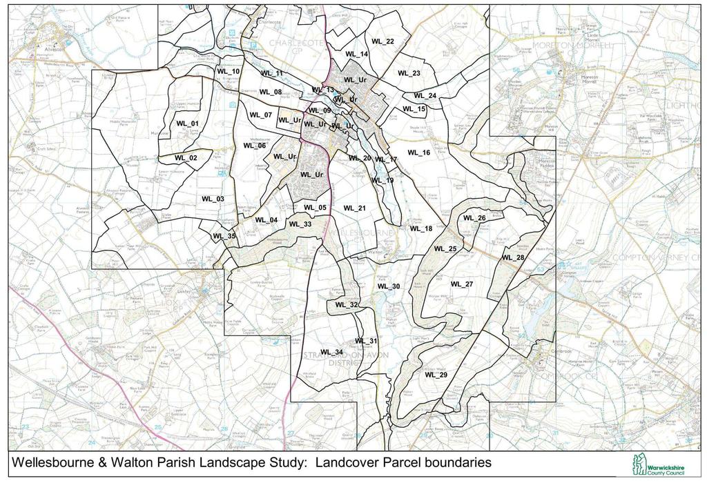
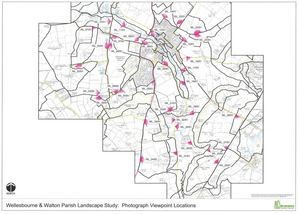
4 1.5 The aim of this study was to provide an analysis of landscape character (including historic) for the whole Parish, identifying areas of low, moderate and high quality. 1.6 The landscape assessment comprises: a. The Landscape Description Units (LDU) that covered the settlement edge; b. Landscape sensitivity analysis looking at the LDUs for potential areas of change as a desk top exercise; c. Further defining the LDUs at a lower level into a number of appropriate Land Cover Parcels (LCPs). This work was undertaken by landscape consultant Steven Warnock and involved sub-dividing the LDUs utilising: the Land Description Units produced under the Living Landscapes Project in 2003/04; the County Council s Historic Landscape Character; and the Habitat Biodiversity Audit. This was essentially a desk-top exercise based on land directly adjacent to, and within, the settlements; d. A field exercise to gather information on verification of character, condition, function, tranquillity and visual quality; e. Site specific analysis on the above information and f. Recommendations on how to improve, enhance, or restore the landscape. These will be discussed at a workshop / meeting and included in the final version of this document. 1.7 The Land Cover Parcels are referred to as zones in this report and are shown on the map on page 8. It should be noted that there is no public access to WL_26, WL_32 and WL_33 and therefore only limited survey information is available for these zones. Zone WL_12 has not been surveyed owing to its urban classification and location within a Conservation Area. 1.8 Information on each zone has been set out in the Appendix in numerical order. Representative photographs of each zone are included after the written notes and a plan showing the locations of the photograph viewpoints can be found on page 9. 3
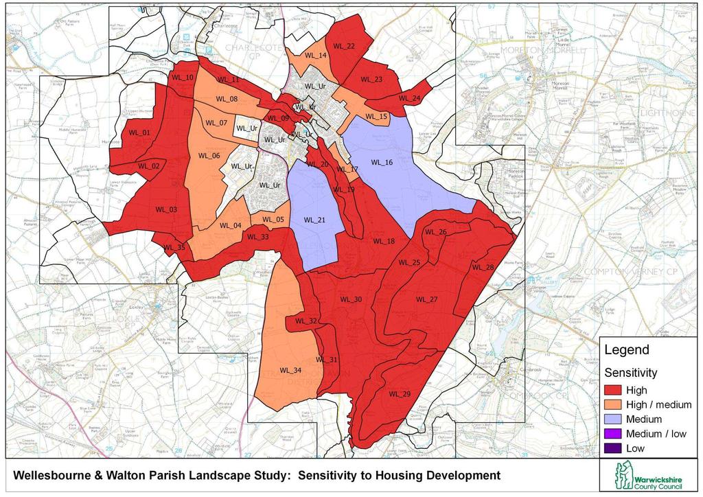
5 2.0 Methodology 2.1 The methodology used for the Landscape Sensitivity and Ecological and Geological Study undertaken for Warwick District Council in 2013 was broadly followed for this assessment. The desk top study has been prepared by landscape consultant Landscape Matters together with an analysis of sensitivity of Land Description Units (LDUs) using a method based on three aspects of inherent sensitivity: ecological, cultural and visual. These LDUs have provided the context to the study and within these broadly defined areas sit the Land Cover Parcels (LCPs). Information on each relevant LCP has been set out in the Appendix in numerical order. (NB LCPs are referred to as zones in this report.) 2.2 The first step in this study, therefore, was to use the information that was available to us to extend the initial Land Cover Parcel (LCP) analysis. The zones have then been assessed on site using a standard checklist taking into account physical characteristics, visibility, the settlement edge and potential receptors. Other factors such as potential landscape enhancement and mitigation will be developed after discussion with the Neighbourhood Plan group. Each zone report includes an overall site description followed by more detailed field notes. 2.3 The WDC study assigned a landscape sensitivity rating for each zone for both housing and commercial development. However, the focus for this landscape sensitivity assessment is on identifying the landscape value rather than potential development opportunities. The areas of study are defined by the character of the landscape and settlement edge, not individual fields, in a similar vein to the Landscape Sensitivity Study for Stratford on-avon District conducted in 2011/ To clarify, a landscape s sensitivity at the LCP, or zone, level is defined as the sensitivity of that landscape to a particular type of change or development. Development in this case would either be for housing or commercial uses. The sensitivity of zones to commercial development will be higher than to housing development because of its larger scale and height, predicted effect within the landscape setting and its potential effect on adjacent residential areas. 2.5 Areas of high sensitivity have tended to be those of intrinsically stronger landscape character / condition, those in open countryside not closely associated with a settlement, those acting as a setting to Conservation Areas, listing buildings or Sites of Ancient Monuments, those adjacent to ancient 4
6 woodlands, on steep or prominent slopes, or those forming green wedges within or between settlements. There is a need to maintain these tracts of open space that feature on the edge or within settlements to maintain the quality of life for residents. 2.6 Individual LCPs have scored a sensitivity ranging from High, High-medium, Medium, Medium-low to Low. Refer to the following table for explanatory notes. Table 1 Sensitivity High Highmedium Medium Medium-low Low Sensitivity Definition Definition Landscape and / or visual characteristics of the zone are very vulnerable to change and / or its intrinsic values are high and the zone is unable to accommodate the relevant type of development without significant character change or adverse effects. Thresholds for significant change are very low. Landscape and / or visual characteristics of the zone are vulnerable to change and / or its intrinsic values are medium-high and the zone can accommodate the relevant type of development only in limited situations without significant character change or adverse effects. Thresholds for significant change are low. Landscape and / or visual characteristics of the zone are susceptible to change and / or its intrinsic values are moderate but the zone has some potential to accommodate the relevant type of development in some situations without significant character change or adverse effects. Thresholds for significant change are intermediate. Landscape and / or visual characteristics of the zone are resilient to change and / or its intrinsic values are medium-low and the zone can accommodate the relevant type of development in many situations without significant character change or adverse effects. Thresholds for significant change are high. Landscape and / or visual characteristics of the zone are robust or degraded and / or its intrinsic values are low and the zone can accommodate the relevant type of development without significant character change or adverse effects. Thresholds for significant change are very high. Table reproduced with kind permission from Landscape Matters 5
7 3.0 Summary of findings and conclusions 3.1 The parish of Wellesbourne and Walton lies within National Character Areas 106 Severn and Avon Vales and 96 Dunsmore and Feldon, and at County level the Avon Valley and Feldon as defined within the Warwickshire Landscapes Guidelines (1993). The landscape of the parish is very rural in character comprising, in the main, mixed farmland. It is generally a medium to large scale, open to framed landscape with a greater proportion of tree cover to the south and east. Significant areas of woodland include Wellesbourne Wood, Smatchley Wood, Walton Wood, Bath Hill Wood, and Bowshot Wood (all ancient woodland). Field boundaries are mostly mixed hedgerows, including some elm, the majority of which have become redundant and gappy. Hedgerow trees are often scattered to infrequent and of mixed age, whilst trees along the river corridor (WL_11 and WL_19) are more frequent but often overmature. 3.2 The well wooded landscape of the Feldon Parklands contributes to the overall landscape structure, particularly in the zones to the south of the settlement. Field ponds are present, but are not a feature that is widespread, with some of the more significant ones occurring within zones WL_03, WL_16, WL_21 and WL_ Topography within the parish ranges from the relatively flat river floodplain at about 50m AOD to the steep wooded scarp slopes which rise to just over 100m AOD. Several zones have ground which rises to around 100m AOD, which gives rise to prominent skylines that would be unsuitable for development. 3.4 Views within the parish vary in extent, with some zones being quite open and therefore more visible, e.g. WL_03, WL_06, WL_22, WL_23, WL_16 and WL_21. Others are more contained, such as WL_04, WL_05, WL_11 and the wooded zones. Views are generally contained by landform and vegetation in adjacent zones but there are some longer distance views beyond the parish boundary towards Warwick and hills to the south-west. Local landmarks such as Walton Hall, the church tower of St Peters, the distinctive chimneys of Staple Hill House and the Vulcan bomber at the airfield are key features, whereas the glasshouses to the crop research centre and commercial units on the west of the settlement act as detractors. 3.5 Tranquillity levels across most of the parish are high or medium, with few urban noise sources, limited views of development and few people. Whilst the parish is dissected by the A429 as well as B-roads and minor roads, these are often well screened and are generally only apparent from fairly close by. Tranquillity is lowered in the vicinity of these roads due to the noise and visibility of traffic, signs etc. However, even in these areas tranquillity is rated no lower than 6
8 medium, as the zone is assessed as a whole. The airfield also lowers the tranquillity of the zones in its vicinity. 3.6 As the whole parish is very rural, consisting predominantly of farmland, the zones relate visually and functionally to each other, especially those to the north, south and east of the settlement We recommend the following landscape enhancements: Gap up and manage hedgerows to enhance field pattern and increase biodiversity value. Increase the number of hedgerow trees by planting locally occurring native species such as oak and field maple, or encouraging natural regeneration. Manage the river and stream courses, including the trees and other vegetation, in order to increase their potential as green corridors for both biodiversity and recreation. Where appropriate (i.e. in those areas which form part of the Feldon Parklands Landscape Character Area) conserve and enhance the overall structure and well wooded character of the landscape. Encourage additional tree cover along the river corridor, either through natural regeneration or through native-species planting, to strengthen the links with the surrounding wooded scarps. Maintain the rural character of the river corridor throughout the village and its wider setting, to ensure the continuity of the historic reference to its former division of the village into two separate communities. Any new developments should have a landscape buffer of native, locallyoccurring species where they abut non-built up areas, to ensure they blend into the surrounding landscape and do not create a hard urban edge. These buffers should create links between open space within the developments and the wider countryside beyond, in order to increase the potential for green biodiversity corridors. 7
9 Appendix 1 Maps and Assessment Sheets A1.0 Explanation of assessments A1.1 The data for each zone is set out on the following pages. Three maps precede the notes; one showing the boundaries of the zones, one showing the locations of the photograph viewpoints and the third showing the sensitivity rating of each zone. A1.2 The notes for individual zones are written into summaries followed by a supporting desk top and site survey assessment (where public access is available). A1.3 Desk top study information, based on landcover, landform, settlement pattern, origin, etc., has been collated as part of the definition of each zone. Planning designations such as Green Belt, Ancient woodland, biodiversity and historic / archaeological interest have also been recorded. A1.4 Each zone has then been assessed in the field using a standard checklist taking into account physical characteristics, key views, intervisibility, tranquillity, the settlement edge, potential receptors and other factors such as landscape enhancement / mitigation. A1.5 The sensitivity rating for each zone relates to the zone as a whole and has not been divided up further, e.g. on a field by field basis. Therefore, if a zone is rated as, for example, medium sensitivity, this does not necessarily mean the whole of the zone is suitable for development, but just that part of it is. The notes under the heading Potential for housing / commercial development give the necessary detail for each zone. 8
10 9
11 10
12 11
13 Zone: WL_01 Settlement: Wellesbourne Parish: Wellesbourne & Walton Site description This zone comprises a medium scale, mixed farmland on rising ground. There are scattered to infrequent trees along the stream course, within the immediate area to the stud farm buildings and around field ponds, but elsewhere tree cover is infrequent creating an open to framed landscape. Roadside hedgerows are generally intact, but are now outgrown and function as a screen to adjacent residential development within the hamlet of Hunscote and to the fields surrounding the stud farm. The condition of internal hedgerows varies from gappy to good e a ples of A li e hedges. Hedge o t ees a e i f e ue t a d lost hedgerow lines have been replaced by fencing to enclose the paddocks. The zone borders the stream course, a short section of the Stratford Road and part of Hunscote Lane, a rural lane. There are views into the zone from the Stratford Road, where the ground is at a higher level, and from Loxley Lane in adjoining zone LCP WL_03. Potential for housing / commercial development The zone has high sensitivity and development is considered inappropriate due to rising ground, a relatively intact field pattern and complete detachment from the existing settlement. Policy suggestions Gap up hedgerows, including planting hedgerow trees. Strengthen the wooded character of the streamline. Landscape characteristics LDU Level Physiographic Ground type Landcover Settlement pattern Cultural sensitivity Ecological sensitivity Visual sensitivity (DESK TOP) VALE ORCHARD BELT Loamy brown soils Arable farmlands Villages / small farms Low Low Low Land Cover Parcel data Landscape / planning Green Belt Pa ks, Gd s & A e it G ee pa es A ie t oodla d TPO unknown Biodiversity I Lo al Wildlife ites Wa ks Wildlife T ust ese es Historic /archaeology Co s. A ea AM Histo i Pa ks / Gd s Listed Blgs egiste ed Battlefield 12
14 Other Flood part stream course Characteristics Landform Soft rock lowlands Land use Mixed farming Field boundaries Type hedgerows Species mixed Condition redundant Mgmt outgrown (FIELD SURVEY) Hedge /stream trees Extent scattered - insignificant Age structure mixed Other trees Extent none Age structure n/a Patch survival Extent relic Mgmt intensive Ecological corridors Condition declining Intensity of use Impact high Pattern Settlement pattern development edge Other built features - Presence of water stream course Scale medium -large Sense of enclosure framed Diversity simple Skyline Higher ground in the west and south-west of the zone gives rise to a prominent skyline. Key views Views are of a farmed landscape, predominantly rural in nature, although industrial units and airfield buildings etc. detract from this to some extent. 13
15 Intervisibility Site observation Medium The zone is more visible from the east. Tranquillity Noise sources: Urban views: Presence of people: Tranquillity rating: Traffic on the B4086 in the northern part of the zone; some aircraft noise. Industrial buildings and airfield Infrequent High / Medium Functional relationship The zone forms part of the wider farmed landscape. Visual relationship The zone relates visually to the surrounding farmed landscape. Settlement edge The airfield and industrial units on the western edge of the settlement are softened by intervening vegetation. Key receptors Rural residents Road users Sensitivity High Low 14

16 WL_01/01: View from Stratford Road looking south-east. 15
17 Zone: WL_02 Settlement: Wellesbourne Parish: Wellesbourne & Walton Site description The zone comprises a medium to large scale, relatively flat, mixed farmland, which rises to the east. It has poor to relic roadside hedgerow permitting glimpsed views into adjacent fields of sheep grazing and farm buildings. The combination of dense to scattered hedgerow trees, wooded stream course and tree cover around the farm and kennels create a framed to enclosed landscape. It is not possible to view the middle field. However, internal hedges are trimmed enabling views of the wider farmed landscape and wooded horizon. Potential for housing / commercial development This zone has high sensitivity because it functions as part of the wider farmed landscape, therefore development is considered inappropriate. Policy suggestions Gap up roadside hedgerow, including replacing hedgerow trees. Landscape characteristics LDU Level Physiographic Ground type Landcover Settlement pattern Cultural sensitivity Ecological sensitivity Visual sensitivity (DESK TOP) TERRACE FARMLANDS Loamy Brown soils Arable farmlands Villages / small farms Moderate Low Moderate Land Cover Parcel data Landscape / planning Green Belt Pa ks, Gd s & A e it G ee pa es A ie t oodla d TPO unknown Biodiversity I Lo al Wildlife ites Wa ks Wildlife T ust ese es Historic /archaeology Co s. A ea AM Histo i Pa ks / Gd s Listed Blgs egiste ed Battlefield Other Flood - Characteristics Landform Land use Soft rock vales and valleys Mixed farming 16
18 Field boundaries Type Species Condition Mgmt Hedge /stream trees Extent Age structure Other trees Extent Age structure Patch survival Extent Mgmt Ecological corridors Condition Intensity of use Impact (FIELD SURVEY) hedgerows mixed poor - relic mixed dense - scattered over mature apparent mixed localised intensive declining moderate Pattern Settlement pattern hamlet Other built features - Presence of water stream course Scale medium - large Sense of enclosure framed - enclosed Diversity simple Skyline This is mostly formed by hedgerows and trees, but is more prominent where ground rises in the eastern part of the zone. Key views Views are of a medium to large scale farmed landscape, framed by hedgerows and trees, and are very rural in nature. Intervisibility Site observation Low The zone is not very visible from the surrounding area due to landform and intervening vegetation. 17
19 Tranquillity Noise sources: Some aircraft noise Urban views: - Presence of people: Infrequent Tranquillity rating: High Functional relationship The zone forms part of the wider farmed landscape. A stream course running though the zone links to the wider area and forms a wildlife corridor. Visual relationship Hedgerow trees provide a visual link to the woodlands beyond the zone. Settlement edge N/A Key receptors Rural residents Sensitivity High 18

20 WL_02/01: View from Hunscote Lane looking south-east. 19
21 Zone: WL_03 Settlement: Wellesbourne Parish: Wellesbourne & Walton Site description This zone comprises an open, medium to large scale, flat, mixed farmed landscape. Hedgerow condition varies from redundant to relic with the loss of roadside hedgerow and very gappy internal hedges. There is a section of recently replanted hedgerow off Hunscote Lane. Generally hedgerow trees range from scattered (alongside the stream course) to insignificant. Other trees are apparent, forming small regular shaped tree belts that connect to, and enhance, hedgerow corridors within the central part of the zone. The conifer screen to farm buildings and caravan park / caravan storage is a detractor in this otherwise rural landscape. Potential for housing / commercial development This zone has high sensitivity because it functions as part of the wider farmed landscape. The open nature of this landscape type means development would be highly visible, even with screen planting, and is therefore considered inappropriate. Policy suggestions Gap up hedgerows, including replacing hedgerow trees. Conserve and enhance the wooded character of streamlines. Landscape characteristics LDU Level Physiographic Ground type Landcover Settlement pattern Cultural sensitivity Ecological sensitivity Visual sensitivity (DESK TOP) TERRACE FARMLANDS Loamy Brown soils Arable farmlands Villages / estate farms Low Low Low Land Cover Parcel data Landscape / planning Green Belt Pa ks, Gd s & A e it G ee pa es A ie t oodla d TPO unknown Biodiversity I Lo al Wildlife ites Wa ks Wildlife T ust ese es Historic /archaeology Co s. A ea AM Histo i Pa ks / Gd s Listed Blgs egiste ed Battlefield Other Flood - 20
22 Characteristics Landform Land use Field boundaries Type Species Condition Mgmt Hedge /stream trees Extent Age structure Other trees Extent Age structure Patch survival Extent Mgmt Ecological corridors Condition Intensity of use Impact Soft rock vales and valleys Mixed farming (FIELD SURVEY) Hedgerows mixed redundant trimmed scattered - insignificant mixed apparent immature relic intensive / traditional declining / fragmented high Pattern Settlement pattern - Other built features caravan park and caravan storage Presence of water stream courses / field pond(s) Scale medium - large Sense of enclosure open Diversity simple Skyline This is quite varied and not particularly prominent. Key views Views are of a medium to large scale, flat farmed landscape and are quite open in character. Some caravans, conifer hedge and containers etc. around Three Bridges Farm are a slight detractor, as are industrial units and airfield buildings beyond the zone, in views to the east. 21
23 Intervisibility Site observation Medium The flat, open nature of the zone makes it more widely visible. Tranquillity Noise sources: Urban views: Presence of people: Tranquillity rating: Aircraft; some road noise. Airfield and industrial units in adjacent zones. Infrequent Medium Functional relationship The zone forms part of the wider farmed landscape. PRoW SD79 provides a link to Loxley and a stream course along the western boundary of the zone links to the wider area and forms a wildlife corridor. Visual relationship The farmland links visually with that to the west and the flat topography links to the airfield to the east. Settlement edge N/A Key receptors Rural residents Users of PRoW Users of Caravan Park Road users Sensitivity High High High Medium / low 22


24 WL_03/01: View from Loxley Lane looking west. WL_03/02: View from PRoW SD79 looking west. 23
25 Zone: WL_04 Settlement: Wellesbourne Parish: Wellesbourne & Walton Site description The zone has been partially covered by W_08 of the 2011 Stratford Landscape Sensitivity Study and subsequently split into two separate zones WL_04 and WL_05 because of different land management and the scale and shape of the underlying field pattern. It is a relatively flat, medium scale, pastoral landscape enclosed by trees. A small part in the north of the zone is currently being developed for housing. There is a mix of farm buildings and a small number of individual residential properties screened by tree belts. At the time of the survey Loxley Road was restricted to access to frontages only. The roadside hedgerow is in good condition with scattered to infrequent hedgerow trees. A couple of individual field trees have survived, which may be indicative of former hedgerow lines. Internal hedges are becoming very gappy, but still retain scattered over-mature hedge trees. The ancient woodland of Wellesbourne Wood forms a backdrop to the zone. Potential for housing / commercial development Landscape sensitivity of high / medium identified by the Stratford Landscape Sensitivity Study for W_08 remains unchanged, although WL_04 now covers a wider area, extending up to the wooded scarp slope, and any further development in this zone would adversely impact on the view towards the scarp. Policy suggestions Provide increased tree planting to edge of new development. Maintain pastoral qualities. Conserve and enhance existing tree cover. Landscape characteristics LDU Level Physiographic Ground type Landcover Settlement pattern Cultural sensitivity Ecological sensitivity Visual sensitivity (DESK TOP) TERRACE FARMLANDS Loamy Brown soils Arable farmlands Villages / estate farms Low Low Low Land Cover Parcel data Landscape / planning Green Belt Pa ks, Gd s & A e it G ee pa es A ie t oodla d TPO unknown Biodiversity I Lo al Wildlife ites Wa ks Wildlife T ust ese es 24
26 Historic /archaeology Co s. A ea AM Histo i Pa ks / Gd s Listed Blgs egiste ed Battlefield Other Flood - Characteristics Landform Land use Field boundaries Type Species Condition Mgmt Hedge /stream trees Extent Age structure Other trees Extent Age structure Patch survival Extent Mgmt Ecological corridors Condition Intensity of use Impact Soft rock vales and valleys Pastoral (FIELD SURVEY) hedgerows mixed good (roadside) redundant relic (internal) trimmed scattered over mature apparent mixed relic traditional declining moderate Pattern Settlement pattern settlement edge / new development Other built features - Presence of water stream course Scale medium Sense of enclosure enclosed Diversity simple Skyline This is formed by trees on the wooded scarp slope to the south and west and roadside vegetation to the north. 25
27 Key views Views are of a medium scale pastoral farmland and are enclosed by surrounding trees. Intervisibility Site observation Low Landform and tree cover limit views into and out of the zone. Tranquillity Noise sources: Machines on adjacent construction site Urban views: - Presence of people: Infrequent Tranquillity rating: High / medium Functional relationship The zone forms a pocket of pasture surrounded mainly by ancient woodland, the airfield and settlement edge / new development. There are small links to the surrounding farmland in the north-west corner (WL_03) and east (WL_05). Visual relationship The zone is visually enclosed and has little relationship with the surrounding area, although hedgerow and roadside trees provide a visual link with the surrounding woodland. Settlement edge N/A Key receptors Rural residents Road users Sensitivity High Medium / low 26

28 WL_04/01: View from Loxley Road looking south. 27
29 Zone: WL_05 Settlement: Wellesbourne Parish: Wellesbourne & Walton Site description The zone has been covered by W_08 of the 2011 Stratford Landscape Sensitivity Study and subsequently split into two separate zones WL_04 and WL_05 because of different land management and the scale and shape of the underlying field pattern. The zone lies between the current settlement and Wellesbourne Wood (LCP_33), an ancient woodland. It comprises a series of small to medium scale pastoral fields with overgrown roadside hedgerows and is completely enclosed to the south by woodland. The settlement edge is screened by boundary vegetation with recently installed garden fencing acting as a detractor. Since there are no local public rights of way it is only possible to view the zone from Ettington Road through gaps in the roadside hedgerow. Internal hedgerows are trimmed and their condition is becoming gappy with mature scattered to infrequent hedgerow trees. Potential for housing / commercial development The landscape sensitivity of high / medium identified by the Stratford Landscape Sensitivity Study remains unchanged. It is our understanding that the whole of this zone has already been identified for development. Policy suggestions N/A Landscape characteristics LDU Level Physiographic Ground type Landcover Settlement pattern Cultural sensitivity Ecological sensitivity Visual sensitivity (DESK TOP) TERRACE FARMLANDS Loamy Brown soils Arable farmlands Villages / estate farms Low Low Low Land Cover Parcel data Landscape / planning Green Belt Pa ks, Gd s & A e it G ee pa es A ie t oodla d TPO unknown Biodiversity I Lo al Wildlife ites, Wa ks Wildlife T ust ese es Historic /archaeology Co s. A ea AM Histo i Pa ks / Gd s Listed Blgs egiste ed Battlefield 28
30 Other Flood - Characteristics Landform Land use Field boundaries Type Species Condition Mgmt Hedge /stream trees Extent Age structure Other trees Extent Age structure Patch survival Extent Mgmt Ecological corridors Condition Intensity of use Impact Soft rock vales and valleys Mixed farming (FIELD SURVEY) hedgerows mixed redundant mixed scattered - infrequent mixed None n/a relic neglected declining high Pattern Settlement pattern settlement edge Other built features - Presence of water - Scale small - medium Sense of enclosure enclosed Diversity simple Skyline This is formed by the wooded scarp slope south of the zone and perimeter hedgerows / trees in other directions. Key views Views are of a rural farmed landscape, enclosed by the wooded scarp slope and perimeter hedgerows. There are glimpsed views of the settlement edge from the A429 and garden fences detract from the rural character. 29
31 Intervisibility Site observation Low Landform and vegetation limit views into and out of the zone. Tranquillity Noise sources: Urban views: Presence of people: Tranquillity rating: Road traffic (A429) Edge of settlement Infrequent Medium Functional relationship The zone forms part of the farmed landscape to the west (WL_04) and, to some extent, the east, although it is separated by the A429. Visual relationship Perimeter trees provide a visual link to the surrounding woodland. Settlement edge Glimpsed views of the modern settlement edge are apparent from the A429, although the edge is softened to some extent by garden vegetation. Key receptors Urban residents Road users Sensitivity High Low 30

32 WL_05/01: View from Ettington Road looking south-west. 31
33 Zone: WL_06 Settlement: Wellesbourne Parish: Wellesbourne & Walton Site description The zone has been covered by W_09 of the 2011 Stratford Landscape Sensitivity Study and subsequently split into two separate zones WL_06 and WL_07. While there is no obvious change in land use, management or contours evident on the ground it is the ground type and Landscape Description Unit (see explanatory note within the Introduction) that separates the two zones. The landscape is open and flat, comprising Wellesbourne airfield and surrounding agricultural land. Overall the roadside hedgerow is in good condition with scattered hedgerow trees. Hedgerows are trimmed, with the majority of internal boundaries defined by low fencing. There is a small tree belt connecting to a hedgerow line with scattered hedgerow trees within the southern part of the zone. Potential for housing / commercial development Landscape sensitivity of high / medium identified by the Stratford Landscape Sensitivity Study remains unchanged. Policy suggestions Refer to Stratford Landscape Sensitivity Study for potential landscape enhancement and mitigation. Landscape characteristics LDU Level Physiographic Ground type Landcover Settlement pattern Cultural sensitivity Ecological sensitivity Visual sensitivity (DESK TOP) TERRACE FARMLANDS Loamy Brown soils Arable farmlands Villages / estate farms Low Low Low Land Cover Parcel data Landscape / planning G ee Belt Pa ks, Gd s & A e it G ee pa es A ie t oodla d TPO unknown Biodiversity I Lo al Wildlife ites Wa ks Wildlife T ust ese es Historic /archaeology Co s. A ea AM Histo i Pa ks / Gd s Listed Blgs egiste ed Battlefield Other Flood - 32
34 Characteristics Landform Land use Field boundaries Type Species Condition Mgmt Hedge /stream trees Extent Age structure Other trees Extent Age structure Patch survival Extent Mgmt Ecological corridors Condition Intensity of use Impact Soft rock vales and valleys Airfield (FIELD SURVEY) hedgerows (roadside) mixed good trimmed scattered (roadside) over mature insignificant (southern part of zone only) over mature relic intensive fragmented high Pattern Settlement pattern settlement edge Other built features airfield and associated buildings / industrial units Presence of water - Scale n/a Sense of enclosure open Diversity simple Skyline This is quite varied, comprising a mixture of vegetation, industrial units and airfield buildings, however the openness of the zone makes the skyline more apparent. Key views A flat, open landscape comprising Wellesbourne airfield and agricultural land. A Vulcan bomber forms a landmark in the northern corner of the zone. Detractors are commercial units to the east and some airfield buildings to the west. 33
35 Intervisibility Site observation Medium The zone is visible from surrounding areas. Tranquillity Noise sources: Urban views: Presence of people: Tranquillity rating: Aircraft Industrial units; airfield buildings, aircraft etc. Many Low Functional relationship Functioning airfield, links to zone WL_07 (also part of airfield), but otherwise a discrete area. Visual relationship Although there is some agricultural land within this zone, visually it relates more to the commercial edge of the settlement to the east than the surrounding farmland. Settlement edge Commercial units on edge of settlement. Key receptors Adjacent roads (incl. National Cycle Route 41 on Loxley Lane) Sensitivity Medium 34


36 WL_06/01: View from Loxley Lane looking east. WL_06/02: View from Loxley Road looking north. 35
37 Zone: WL_07 Settlement: Wellesbourne Parish: Wellesbourne & Walton Site description The zone has been covered by W_09 of the 2011 Stratford Landscape Sensitivity Study and subsequently split into two separate zones WL_06 and WL_07. While there is no obvious change in land use, management or contours evident on the ground it is the ground type and the Landscape Description Unit (see explanatory note within the Introduction) that separates the two zones. The landscape is open and flat comprising part of Wellesbourne airfield and surrounding agricultural land. However, the roadside hedgerow varies in condition from redundant to relic, with scattered to infrequent hedgerow trees, and a wide open section that could be gapped up. The hedgerow is trimmed. Potential for housing / commercial development Landscape sensitivity of high / medium identified by the Stratford Landscape Sensitivity Study remains unchanged. Policy suggestions Refer to Stratford Landscape Sensitivity Study for potential landscape enhancement and mitigation. Landscape characteristics LDU Level Physiographic Ground type Landcover Settlement pattern Cultural sensitivity Ecological sensitivity Visual sensitivity (DESK TOP) TERRACE FARMLANDS Sandy Brown soils Arable farmlands Villages / estate farms Low Low Moderate Land Cover Parcel data Landscape / planning G ee Belt Parks, Gdns & Amenit G ee pa es A ie t oodla d TPO unknown Biodiversity I Lo al Wildlife ites Wa ks Wildlife T ust ese es Historic /archaeology Co s. A ea AM Histo i Pa ks / Gd s Listed Blgs egiste ed Battlefield Other Flood - 36
38 Characteristics Landform Land use Field boundaries Type Species Condition Mgmt Hedge /stream trees Extent Age structure Other trees Extent Age structure Patch survival Extent Mgmt Ecological corridors Condition Intensity of use Impact River valleys Airfield (FIELD SURVEY) hedgerows mixed / elm redundant - relic trimmed scattered to insignificant over mature n/a n/a relic neglected fragmented low Pattern Settlement pattern - Other built features industrial units associated with airfield Presence of water - Scale medium to large Sense of enclosure open Diversity simple Skyline This comprises roadside vegetation, commercial units and airport buildings. The openness makes the skyline quite prominent. Key views A flat, open landscape comprising Wellesbourne airfield and agricultural land. A Vulcan bomber forms a landmark in the west of the zone. Detractors are commercial units to the east and some airfield buildings to the west. 37
39 Intervisibility Site observation Tranquillity Noise sources: Urban views: Presence of people: Tranquillity rating: Medium Aircraft, road traffic Commercial & airfield buildings Many Low Functional relationship Functioning airfield, links to zone WL_06 (also part of airfield), but otherwise a discrete area. Visual relationship Although there is some agricultural land within this zone, visually it relates more to the commercial edge of the settlement to the east than the surrounding farmland. Settlement edge Commercial units on edge of settlement. Key receptors Adjacent roads Sensitivity Medium 38

40 WL_07/01: View from Stratford Road looking south. 39
41 Zone: WL_08 Settlement: Wellesbourne Parish: Wellesbourne & Walton Site description The zone has been covered by W_11 of the 2011 Stratford Landscape Sensitivity Study. It comprises an open, relatively flat, medium to large scale agricultural landscape with few features. Internal field boundaries are mainly defined by chain link fencing creating an urban feel to what is a rural landscape. The sewage works with associated conifer screen also act as detractors in this landscape. There are some internal hedges but these are very gappy with an insignificant number of hedgerow trees. Tree cover is restricted to the edge of the vehicular track to the sewage works and within roadside hedgerows. Roadside hedgerows are trimmed. Potential for housing / commercial development Landscape sensitivity of high / medium identified by the Stratford Landscape Sensitivity Study remains unchanged. Policy suggestions Refer to Stratford Landscape Sensitivity Study for potential landscape enhancement and mitigation. Hedgerow cover should be increased across the zone especially where current field boundaries are defined by chain link fencing to enhance riverside PRoW. Landscape characteristics LDU Level Physiographic Ground type Landcover Settlement pattern Cultural sensitivity Ecological sensitivity Visual sensitivity (DESK TOP) TERRACE FARMLANDS Sandy Brown soils Arable farmlands Villages / estate farms Low Low Moderate Land Cover Parcel data Landscape / planning Green Belt Pa ks, Gd s & A e it G ee pa es A ie t oodla d TPO unknown Biodiversity I Lo al Wildlife ites Wa ks Wildlife T ust ese es Historic /archaeology Co s. A ea SAMS Histo i Pa ks / Gd s Listed Blgs egiste ed Battlefield Other Flood - 40
42 Characteristics Landform Land use Field boundaries Type Species Condition Mgmt Hedge /stream trees Extent Age structure Other trees Extent Age structure Patch survival Extent Mgmt Ecological corridors Condition Intensity of use Impact River valleys Cropping (FIELD SURVEY) hedgerows mixed good (roadside) scattered insignificant (roadside) n/a insignificant n/a relic intensive fragmented high Pattern Settlement pattern - Other built features sewage works Presence of water - Scale medium - large Sense of enclosure open Diversity uniform Skyline Landform and a lack of vegetation within the zone make the skyline generally quite prominent. Key views An open, medium to large scale agricultural landscape with few features. A sewage works with associated conifer screen detracts from the otherwise rural nature. Intervisibility Site observation Medium The zone is visible, especially from the Stratford Road to the south. 41
43 Tranquillity Noise sources: Urban views: Presence of people: Tranquillity rating: Roads; aircraft Sewage works; industrial units to the south-east Infrequent Medium Functional relationship The zone forms part of the wider farmed area. Visual relationship Visually the zone forms part of the River Dene corridor and separates Charlecote and Wellesbourne. Settlement edge Commercial development abuts the south-eastern edge of the zone but is softened by tree planting. Key receptors Users of PRoW SD125b Roads (incl. National Cycle Route 41) Sensitivity High High 42

44 WL_08/01: View from access track to sewage works looking north-west. 43
45 Zone: WL_09 Settlement: Wellesbourne Parish: Wellesbourne & Walton Site description The zone has been covered by W_10 of the 2011 Stratford Landscape Sensitivity Study and has been identified as an Area of Restraint. This is a flat, small to medium scale, arable landscape which provides a rural landscape setting south of the river corridor, with the majority of the zone lying within the floodplain. It is almost completely enclosed by outgrown hedgerows and screening vegetation to the bypass. Within the field there is a small cluster of trees around a field pond. To the east there is strong tree cover around a grassed enclosure associated with, Wellesbourne Hall, a listed building. This part of the zone lies within a Conservation Area comprising the historic core to Wellesbourne. The arable landscape to the west visually connects with zone WL_13 through glimpsed views of the church tower and adjacent paddocks from breaks in the roadside hedgerow. New de elop e t has e oa hed upo the zo e s southe ou da eati g a sta k i te al boundary but this may be softened over time by garden vegetation. Potential for housing / commercial development This zone has high sensitivity as it contributes to the setting of the Conservation Area and listed uildi gs, its i po ta e as a g ee o ido li ki g the settle e t ith the ide countryside, and its nature conservation value. Therefore development is considered inappropriate. Policy suggestions Refer to Stratford Landscape Sensitivity Study for potential landscape enhancement and mitigation. Conserve and enhance roadside hedgerow to the Stratford Road. Provide landscape buffer around new development on Stratford Road. Co se e the zo e as pa t of the g ee o ido a d setti g to the Co se atio Area. Conserve and enhance the local landscape character and rural qualities of the pastoral landscape along the river corridor. Landscape characteristics LDU Level Physiographic Ground type Landcover Settlement pattern Cultural sensitivity Ecological sensitivity Visual sensitivity (DESK TOP) TERRACE FARMLANDS Sandy Brown soils Arable farmlands Villages / estate farms Low Low Moderate Land Cover Parcel data Landscape / planning Green Belt Pa ks, Gd s & A e it G ee pa es Ancient woodland TPO unknown 44
46 Biodiversity I Local Wildlife Sites Warks Wildlife T ust ese es Historic /archaeology Cons. Area AM Histo i Pa ks / Gd s Listed Blgs egiste ed Battlefield Other Flood part Characteristics Landform Land use Field boundaries Type Species Condition Mgmt Hedge /stream trees Extent Age structure Other trees Extent Age structure Patch survival Extent Mgmt Ecological corridors Condition Intensity of use Impact River valleys Pastoral (FIELD SURVEY) hedgerows mixed redundant trimmed scattered mixed age insignificant n/a relic intensive declining moderate Pattern Settlement pattern settlement edge Other built features - Presence of water field pond Scale small - medium Sense of enclosure enclosed Diversity simple 45
47 Skyline This is mainly formed by trees and vegetation around the perimeter. Key views A small to medium scale arable landscape, enclosed by good perimeter vegetation. There are glimpsed views of the settlement edge and Church tower, filtered by trees. Intervisibility Site observation Low There are views across the river (WL_11) into WL_13, but otherwise the zone is well screened. Tranquillity Noise sources: Urban views: Presence of people: Tranquillity rating: Road traffic Glimpsed views of settlement edge and new development on the southern edge. Infrequent. Medium Functional relationship The zone forms part of the river corridor / floodplain. Visual relationship The zone connects visually with the river corridor and zone WL_13, and contributes to the setting of the Conservation Area. Settlement edge This is well screened by vegetation although new development on the southern edge is more obvious. Key receptors Urban residents PRoWs Road users Sensitivity High High Low 46

48 WL_09/01: View from Stratford Road looking north-east. 47
49 Zone: WL_10 Settlement: Wellesbourne Parish: Wellesbourne & Walton NB - This zone lies outside the Parish boundary, but as it was included in the LCP map we have surveyed it and included it here. Site description This is a small to medium scale landscape comprising parkland and pasture on gently rising ground. Hedged field boundaries are subsidiary within this zone and it is the degree of enclosure provided by tree cover that creates a sense of scale. Public Right of Way SD126 is defined along its southern edge by protective post and wire fencing permitting open views into Charlecote Park. The roadside boundary is defined by a mix of traditional cleft oak paling fencing, dense to scattered trees and scrub. Pro- active management within Charlecote Park is ensuring continuity of woodland pasture. South of Charlecote Park is an area of small to medium scale farmland managed as pasture with post and rail boundaries in the main. Conifer screen planting is a detractor. A lack of hedgerows and trees in this part of the zone make this more visible to the surrounding area than the northern part. Potential for housing / commercial development This zone has high sensitivity due to the parkland landscape and therefore development is therefore considered inappropriate. Policy suggestions Conserve and enhance parkland setting. Landscape characteristics LDU Level Physiographic Ground type Landcover Settlement pattern Cultural sensitivity Ecological sensitivity Visual sensitivity (DESK TOP) TERRACE FARMLANDS Sandy Brown soils Arable farmlands Villages / estate farms Low Low Moderate Land Cover Parcel data Landscape / planning Green Belt Parks, Gdns & Amenity Green Spaces A ie t oodla d TPO unknown Biodiversity I Local Wildlife Sites Wa ks Wildlife T ust ese es 48
50 Historic /archaeology Cons. Area SAMS Historic Parks / Gdns Listed Blgs egiste ed Battlefield Other Flood part Characteristics Landform Land use Field boundaries Type Species Condition Mgmt Hedge /stream trees Extent Age structure Other trees Extent Age structure Patch survival Extent Mgmt Ecological corridors Condition Intensity of use Impact River valleys Parkland (FIELD SURVEY) hedgerow (roadside) mixed redundant - relic mixed scattered mixed Prominent mixed localised traditional intact - declining low - moderate Pattern Settlement pattern - Other built features - Presence of water River Dene Scale small to medium Sense of enclosure enclosed Diversity simple Skyline This is quite varied and broken up by parkland and hedgerow trees. 49
51 Key views Views are of a small to medium scale landscape comprising parkland and pasture. Individual and groups of field trees frame views. Some traditional cleft oak paling fencing remains alo g the oadside ou da a d Cha le ote Pa k s he d of Fallo Dee a sometimes be seen grazing beneath the parkland trees. Intervisibility Site observation Low / medium A lack of hedgerows and trees in the southern part of the zone make this more visible to the surrounding area than the northern part. Tranquillity Noise sources: Road traffic Urban views: - Presence of people: Infrequent Tranquillity rating: High Functional relationship The zone forms part of Charlecote Park which extends north and west of the zone. The fields of pasture also link with the wider farmed landscape. PRoW SD126 links to the wider area. Visual relationship The zone relates visually to the parkland to the north and west. Settlement edge N/A Key receptors Rural residents PRoW users Road users (incl. National Cycle Route 41) Sensitivity High High High / Medium 50

52 WL_10/01: View from PRoW SD126 looking west. 51
53 Zone: WL_11 Settlement: Wellesbourne Parish: Wellesbourne & Walton Site description The zone has been covered by W_ 12 of the 2011 Stratford Landscape Sensitivity Study and has been identified as an Area of Restraint. Essentially this forms part of the River Dene corridor and is located northwest of the settlement edge and borders a Conservation Area. The zone can be accessed via Public Right of Way (PRoW) SD125b which skirts the edge of a private garden and possible small orchard / extended garden area. The landscape comprises a relatively flat small to medium scale pastoral farmland linked by roadside and riverside trees. The roadside hedgerow is redundant and becoming gappy providing the western boundary to the small orchard / extended garden area. Internal hedgerows vary in condition from relic with only the hedgerow trees surviving to gappy with no hedgerow trees. At the western edge of PRoW SD125b there are views towards a listed building with a substantial modern extension that sits within the zone and the roofs to the garden centre buildings. A further residential property with grounds that extend down to the river edge can be glimpsed from the PRoW. Potential for housing / commercial development Landscape sensitivity of high identified by the Stratford Landscape Sensitivity Study remains unchanged and therefore development is therefore considered inappropriate. Policy suggestions Refer to the Stratford Landscape Sensitivity Study and Areas of Restraint Review July 2011 for landscape enhancement and mitigation. Conserve and enhance the local landscape character and rural qualities of the pastoral landscape along the river corridor. Landscape characteristics LDU Level Physiographic Ground type Landcover Settlement pattern Cultural sensitivity Ecological sensitivity Visual sensitivity (DESK TOP) TERRACE FARMLANDS Sandy Brown soils Arable farmlands Villages / estate farms Low Low Moderate Land Cover Parcel data Landscape / planning Green Belt Pa ks, Gd s & A e it G ee pa es A ie t oodla d TPO unknown Biodiversity I Local Wildlife Sites Wa ks Wildlife T ust ese es 52
54 Historic /archaeology Co s. A ea AM Histo i Pa ks / Gd s Listed Blgs egiste ed Battlefield Other Flood Characteristics Landform Land use Field boundaries Type Species Condition Mgmt Hedge /stream trees Extent Age structure Other trees Extent Age structure Patch survival Extent Mgmt Ecological corridors Condition Intensity of use Impact River valleys Pastoral (FIELD SURVEY) hedgerows mixed redundant - relic trimmed scattered - insignificant mixed apparent mixed localised traditional declining moderate Pattern Settlement pattern - Other built features - Presence of water River Dene Scale small - medium Sense of enclosure framed Diversity simple Skyline This is formed mainly by roadside and riverside trees. Key views Views are of a small scale pastoral landscape and riverside trees. This tree cover means that views are quite enclosed. The only urbanising feature is a chain-link fence running alongside 53
55 PRoW SD125b and occasional glimpsed views of Charlecote Garden Centre to the northwest. Intervisibility Site observation Low Riverside trees restrict views into and out of this zone. Tranquillity Noise sources: Urban views: Presence of people: Tranquillity rating: Some road traffic Chain link fence; occasional glimpsed views of garden centre. Infrequent High / medium (due to road traffic) Functional relationship The river links to the wider area and forms a wildlife corridor. PRoW SD125b and the roads also link to the wider area. Visual relationship Tree cover within the zone provides a visual link with the parkland trees to the west, and with the wooded scarp of Wellesbourne Wood to the south. Settlement edge N/A Key receptors PRoW users Rural residents Road users Sensitivity High High Low 54

56 WL_11/01: View from PRoW SD125b looking north-west. 55
57 Zone: WL_12 Settlement: Wellesbourne Parish: Wellesbourne & Walton Site description This part of the River Dene corridor falls within an urban / amenity zone and forms part of a local wildlife site. It lies within a Conservation Area in close proximity to several listed buildings. Ho e e, e ause of the zo e s u a lassifi atio la ds ape ha a te assessment is not applicable and therefore the parcel has not been surveyed as part of this study. Potential for housing / commercial development N/A Policy suggestions N/A Landscape characteristics LDU Level Physiographic Ground type Landcover Settlement pattern Cultural sensitivity Ecological sensitivity Visual sensitivity (DESK TOP) TERRACE FARMLANDS Sandy Brown soils Arable farmlands Villages / estate farms Low Low Moderate Land Cover Parcel data Landscape / planning Green Belt Pa ks, Gd s & A e it G ee pa es A ie t oodla d TPO unknown Biodiversity I Local Wildlife Sites Warks Wildlife T ust ese es Historic /archaeology Cons. Area AM Histo i Pa ks / Gd s Listed Blgs egiste ed Battlefield Other Flood Characteristics Landform Land use River valleys Urban - amenity 56
58 A field survey has not been undertaken Field boundaries (FIELD SURVEY) Type - Species - Condition - Mgmt - Hedge /stream trees Extent - Age structure - Other trees Extent - Age structure - Patch survival Extent - Mgmt - Ecological corridors Condition - Intensity of use Impact - Pattern Settlement pattern Settlement edge Other built features bridge Presence of water River Dene Scale - Sense of enclosure - Diversity - Skyline Key views Intervisibility Site observation Tranquillity Noise sources: - Urban views: - Presence of people: - Tranquillity rating: - 57
59 Functional relationship Visual relationship Settlement edge Key receptors Sensitivity 58
60 Zone: WL_13 Settlement: Wellesbourne Parish: Wellesbourne & Walton Site description The zone has been covered by W_13 of the 2011 Stratford Landscape Sensitivity Study and has been identified as an Area of Restraint. The zone is located on the north western edge of the settlement, hemmed in by the A429 bypass, Charlecote Road and the River, and includes St Peters Church and churchyard and a restaurant and associated garden. This is a small to intimate scale pastoral landscape that is very gently undulating, rising in the direction of the bypass, and generally enclosed by perimeter trees and hedgerows. Within the zone tree cover is limited to remnant hedgerow lines and mature trees within the churchyard. The stump of a single field tree may be indicative of a former hedgerow line. Internal hedgerows have been replaced by unsightly fencing to paddocks, giving rise to views across the whole zone, with the churchyard trees and church tower visible to the north and the River Dene as a backdrop to the south. The roadside hedgerow has become very gappy along the section adjacent to the bypass, permitting glimpsed views into the zone from the road and from the public footpath. Public Right of Way (PRoW) SD125a is regularly used and connects with two other PRoWs SD125 and SD125b linking the town across the river and providing a rural landscape setting to the church and churchyard. Potential for housing / commercial development This zone has high sensitivity as it contributes to the setting of the Conservation Area and listed uildi gs, its i po ta e as a g ee o ido li ki g the settle e t ith the ide countryside, and its nature conservation value. Therefore development is considered inappropriate. Policy suggestions Refer to Stratford Landscape Sensitivity Study and Areas of Restraint Review for potential landscape enhancement and mitigation. Conserve pastoral qualities. Conserve and enhance the local landscape character and rural qualities of the pastoral landscape along the river corridor. Landscape characteristics LDU Level Physiographic Ground type Landcover Settlement pattern Cultural sensitivity Ecological sensitivity Visual sensitivity (DESK TOP) TERRACE FARMLANDS Sandy Brown soils Arable farmlands Villages / estate farms Low Low Moderate 59
61 Land Cover Parcel data Landscape / planning G ee Belt Pa ks, Gd s & A e it G ee pa es A ie t oodla d TPO unknown Biodiversity I Local Wildlife Sites Wa ks Wildlife T ust ese es Historic /archaeology Co s. A ea AM Histo i Pa ks / Gd s Listed Blgs egiste ed Battlefield Other Flood - Characteristics Landform Land use River valleys Pastoral Field boundaries Type Species Condition Mgmt Hedge /stream trees Extent Age structure Other trees Extent Age structure Patch survival Extent Mgmt Ecological corridors Condition Intensity of use Impact Pattern Settlement pattern Other built features Presence of water (FIELD SURVEY) hedgerow mixed redundant - relic outgrown insignificant n/a apparent overmature relic neglected fragmented moderate edge of Conservation Area church and churchyard, restaurant River Dene 60
62 Scale Sense of enclosure Diversity Intimate framed simple Skyline This is quite varied, comprising mainly trees, but becomes more prominent on the higher ground towards the A429. Key views A small scale pastoral landscape with paddocks. Vegetation around the perimeter of the zone make it very enclosed. The church tower forms a landmark on the skyline to the east. An Indian restaurant, street lights and traffic on the A429 and unsightly paddock fencing are detractors. Intervisibility Site observation Low Perimeter vegetation restricts views to and from areas immediately adjacent. Tranquillity Noise sources: Urban views: Presence of people: Tranquillity rating: Traffic on the A429 Traffic, street lights, Indian restaurant Infrequent Medium / low Functional relationship The zone is contained by the A429, river and settlement edge. Several PRoWs link to the wider area. Visual relationship The zone provides a setting for the church, conservation area and river corridor. Settlement edge Apart from the Indian restaurant the settlement edge is not apparent due to good tree cover around the perimeter of the zone. Key receptors Urban residents PRoWs Road Sensitivity High High Low 61

63 WL_13/01: View from PRoW SD125b looking north-east 62
64 Zone: WL_14 Settlement: Wellesbourne Parish: Wellesbourne & Walton Site description This zone has been covered by W_01 of the 2011 Stratford Landscape Sensitivity Study. It comprises a relatively flat, medium to large scale, arable landscape on the urban fringe, the majority of which lies within the flood plain of the stream. Hedgerows along the urban edge are generally intact, but are now outgrown and function as a screen to adjacent residential development. Internal hedgerows are very gappy with insignificant hedge trees. There are scattered willows and poplars along a stream course, which creates a framed landscape. The zone borders the old Warwick Road, now a footpath / cycleway that connects to PRoW SD128 and the A429. There are glimpsed views of buildings / glasshouses at the University of Wa i k s Welles ou e Ca pus just to the o th of the zo e from PRoW SD128. Potential for housing / commercial development Landscape sensitivity of high / medium identified by the Stratford Landscape Sensitivity Study remains un-changed, however any development should not be detached from the existing settlement and may not be possible due to the floodplain. Policy suggestions Refer to Stratford Landscape Sensitivity Study for potential landscape enhancement and mitigation. Conserve and enhance the wooded character of the streamline. Conserve and enhance tree cover around edge of existing development. Landscape characteristics LDU Level Physiographic Ground type Landcover Settlement pattern Cultural sensitivity Ecological sensitivity Visual sensitivity (DESK TOP) TERRACE FARMLANDS Sandy brown soils Arable farmlands Villages /estate farms Low Low Moderate Land Cover Parcel data Landscape / planning Green Belt Pa ks, Gd s & A e it G ee pa es A ie t oodla d TPO unknown Biodiversity I Lo al Wildlife ites Wa ks Wildlife T ust ese es Historic /archaeology Co s. A ea AM Histo i Pa ks / Gd s Listed Blgs egiste ed Battlefield 63
65 Other Flood part Characteristics Landform River valleys Land use cropping Field boundaries Type hedgerows Species mixed Condition redundant Mgmt outgrown (FIELD SURVEY) Hedge /stream trees Extent scattered - insignificant Age structure mixed Other trees Extent none Age structure n/a Patch survival Extent relic Mgmt intensive Ecological corridors Condition declining Intensity of use Impact high Pattern Settlement pattern development edge Other built features - Presence of water stream course Scale medium -large Sense of enclosure framed Diversity simple Skyline This is formed by vegetation and higher ground beyond the zone to the north and east. Key views Views are of a relatively flat arable landscape. There are glimpsed views of buildings / glasshouses at the U i e sit of Wa i k s Welles ou e Ca pus just to the o th of the zone. 64
66 Intervisibility Site observation Medium Views into the zone from the south and west are limited by vegetation and the settlement edge. The rising ground to the north-east affords longer-distance views into the zone from the Newbold Pacey area. Tranquillity Noise sources: Traffic on the A429; some light aircraft noise. Urban views: Settlement edge; glimpsed views of glasshouses / buildings of The University of Warwick Wellesbourne Campus. Presence of people: - Tranquillity rating: Medium Functional relationship The zone forms part of the wider farmed landscape. The stream forms a wildlife corridor linking to the surrounding area. PRoW SD128 also links to the wider area. Visual relationship The zone relates visually to the farmed landscape to the north and east. Settlement edge This is softened to a large extent by vegetation. Key receptors Urban residents PRoW Road users Sensitivity High High Low 65

67 WL_14/01: View from PRoW SD128 looking north-east. 66
68 Zone: WL_15 Settlement: Wellesbourne Parish: Wellesbourne & Walton Site description The zone has been covered by W_02 of the 2011 Stratford Landscape Sensitivity Study. It comprises a relatively flat, medium to large scale, arable landscape on the urban fringe and includes allotments. The southern edge of the zone is visible from Kineton Road, Wellesbourne Primary School and residential properties on Mountford Close that back onto the fields. There are scattered trees along the stream course but elsewhere tree cover is insignificant. Internal hedgerows have become very gappy with the exception of the hedge boundary to the allotments. Potential for housing / commercial development Landscape sensitivity of high / medium identified by the Stratford Landscape Sensitivity Study remains un-changed, however any development should not be detached from the existing settlement and may not be possible due to the floodplain. Policy suggestions Refer to Stratford Landscape Sensitivity Study for potential landscape enhancement and mitigation. Landscape characteristics LDU Level Physiographic Ground type Landcover Settlement pattern Cultural sensitivity Ecological sensitivity Visual sensitivity (DESK TOP) TERRACE FARMLANDS Sandy brown soils Arable farmlands Villages /estate farms Low Low Moderate Land Cover Parcel data Landscape / planning Green Belt Parks, Gdns & A e it G ee pa es Ancient woodland TPO unknown Biodiversity I Local Wildlife Sites Wa ks Wildlife T ust ese es Historic /archaeology Co s. A ea AM Histo i Pa ks / Gd s Listed Blgs Registered Battlefield Other Flood part 67
69 Characteristics Landform River valleys Land use cropping Field boundaries Type hedgerows Species mixed Condition redundant Mgmt trimmed (FIELD SURVEY) Hedge /stream trees Extent scattered - insignificant Age structure mixed Other trees Extent none Age structure n/a Patch survival Extent relic Mgmt intensive Ecological corridors Condition declining Intensity of use Impact high Pattern Settlement pattern - Other built features - Presence of water stream course Scale medium -large Sense of enclosure framed Diversity simple Skyline This is formed by vegetation and higher ground beyond the zone to the north and east. Key views Views are of a relatively flat arable landscape and allotments. There are glimpsed views of uildi gs / glasshouses at the U i e sit of Wa i k s Welles ou e Ca pus just to the north of the zone and a distant view to Moreton Hall at Moreton Morrell. The modern settlement edge abuts the zone, but is softened by garden vegetation. 68
70 Intervisibility Site observation Medium Views into the zone from the south and west are limited by vegetation and the settlement edge. The rising ground to the north-east affords longer-distance views into the zone from the Newbold Pacey area. Tranquillity Noise sources: Traffic on the A429; some light aircraft noise. Urban views: Settlement edge; glimpsed views of glasshouses / buildings of The University of Warwick Wellesbourne Campus. Presence of people: - Tranquillity rating: Medium Functional relationship The zone forms part of the wider farmed landscape. The stream forms a wildlife corridor linking to the surrounding area. PRoW SD128 also links to the wider area. Visual relationship The zone relates visually to the farmed landscape to the north and east. Settlement edge This is softened to a large extent by vegetation. Key receptors Urban residents PRoW Road users Sensitivity High High Low 69

71 WL_15/01: View from allotments looking north-east. 70
72 Zone: WL_16 Settlement: Wellesbourne Parish: Wellesbourne & Walton Site description The zone has been partially covered by W_03 of the 2011 Stratford Landscape Sensitivity Study, but now extends further to the south-east to the wooded scarp slope of Friz Hill Wood. It comprises a relatively flat and very open, large scale arable landscape with trimmed roadside hedgerows that are becoming gappy, particularly along the lane leading onto Moreton Paddox. Several ash trees have been planted along this lane in an attempt to re-introduce hedgerow trees and are just becoming large enough to have an impact. Trees are restricted to hedgerow lines, stream courses and field ponds. The ancient wooded areas of adjacent zone WL_25 and unnumbered zones to the west help to frame views to the south and west. Internal hedges are also becoming gappy. Potential for housing / commercial development The landscape sensitivity of medium identified by the Stratford Landscape Sensitivity Study remains unchanged for the area covered by W_03, provided that development is restricted to the area specified, i.e. no further east than where PRoW 119a meets the minor road to Staple Hill Farm running north to join the eastern corner of the allotments, and no further south than this road. The remainder of the zone now covered in WL_16 is of high sensitivity due to its openness, its relationship to the wider countryside and connectivity with Friz Hill Wood, and development in this part is considered inappropriate. Policy suggestions Refer to Stratford Landscape Sensitivity Study for potential landscape enhancement and mitigation. Conserve rural character of zone and views to wooded scarp slope. Gap up hedgerows, including additional hedgerow trees. Landscape characteristics LDU Level Physiographic Ground type Landcover Settlement pattern Cultural sensitivity Ecological sensitivity Visual sensitivity (DESK TOP) TERRACE FARMLANDS Sandy brown soils Arable farmlands Villages /estate farms Low Low Moderate Land Cover Parcel data Landscape / planning Green Belt Pa ks, Gd s & A e it G ee pa es Ancient woodland TPO unknown Biodiversity I Local Wildlife Sites Wa ks Wildlife T ust ese es 71
73 Historic /archaeology Co s. A ea AM Histo i Pa ks / Gd s Listed Blgs egiste ed Battlefield Other Flood - Characteristics Landform River valleys Land use cropping Field boundaries Type Hedgerows Species Thorn Condition Redundant Mgmt Trimmed (FIELD SURVEY) Hedge /stream trees Extent Scattered - insignificant Age structure Mixed age Other trees Extent Insignificant Age structure n/a Patch survival Extent Relic Mgmt Intensive Ecological corridors Condition Declining Intensity of use Impact High Pattern Settlement pattern Other built features - Presence of water stream courses Scale large Sense of enclosure open Diversity simple Farm buildings and adjacent individual residential properties, and development edge off Kineton Road. Skyline This is very varied, formed partly by vegetation and buildings within the zone and partly by landform and vegetation beyond. 72
74 Key views Views are of a large scale arable landscape and are very open in character. The modern settlement edge is visible, but is softened by garden vegetation. Views to the south and east are framed by a backdrop of wooded scarp slopes. The former large country house of Staple Hill House, with its tall red brick chimneys, is a landmark feature in this otherwise fairly flat, open landscape. Intervisibility Site observation Medium The open nature of this zone makes it visible, especially from the east. Tranquillity Noise sources: Urban views: Presence of people: Tranquillity rating: Some road traffic; aircraft Settlement edge Infrequent High / medium Functional relationship The zone forms part of the wider farmed landscape. Visual relationship The flatter topography of the zone contrasts with the rising ground beyond. Settlement edge A modern settlement edge of ribbon development abuts the north-west corner of the zone. Key receptors Urban residents Rural residents PRoW Road users Sensitivity High High High High / medium 73

75 WL_16/01: View from junction of PRoW SD119a with minor lane to Staple Hill Farm, looking south-east. 74
76 Zone: WL_17 Settlement: Wellesbourne Parish: Wellesbourne & Walton Site description The zone has been covered by W_11 of the 2011 Stratford Landscape Sensitivity Study. It comprises part of the River Dene corridor and part of the settlement edge to Wellesbourne. The landscape pattern is a relatively flat small to medium scale pastoral field pattern where field boundaries are mainly fenced paddocks. Riverside trees are dense to scattered creating a framed landscape. A newly established thorn hedgerow establishes the boundary to the commercial premises in adjoining zone WL_18. The combination of breaks within both the roadside hedgerow and internal hedgerow permit views of the development edge across the zone. Potential for housing / commercial development Landscape sensitivity of high / medium identified by the Stratford Landscape Sensitivity Study remains unchanged. Policy suggestions Refer to Stratford Landscape Sensitivity Study for potential landscape enhancement and mitigation. Conserve pastoral qualities. Conserve and enhance the local landscape character and rural qualities of the pastoral landscape along the river corridor. Landscape characteristics LDU Level Physiographic Ground type Landcover Settlement pattern Cultural sensitivity Ecological sensitivity Visual sensitivity (DESK TOP) TERRACE FARMLANDS Sandy brown soils Arable farmlands Village / estate farms Low Low Moderate Land Cover Parcel data Landscape / planning Green Belt Pa ks, Gd s & A e it G ee pa es Ancient woodland TPO unknown Biodiversity I Local Wildlife Sites Wa ks Wildlife T ust ese es Historic /archaeology Co s. A ea AM Histo i Pa ks / Gd s Listed Blgs egiste ed Battlefield 75
77 Other Flood part Characteristics Landform Soft Rock Lowlands Land use Pastoral Field boundaries Type Hedgerows Species Thorn Condition Redundant Mgmt Mixed (FIELD SURVEY) Hedge /stream trees Extent Dense - Scattered (River), Scattered - Insignificant (hedgerows) Age structure Over mature Other trees Extent Insignificant Age structure n/a Patch survival Extent Localised Mgmt Neglected Ecological corridors Condition Fragmented Intensity of use Impact Low Pattern Settlement pattern Development edge off Kineton Road and Ash Tree Close. Other built features - Presence of water River Dene Scale small - medium Sense of enclosure open but framed by river corridor Diversity simple Skyline This is quite varied, comprising vegetation and the edge of the settlement. Key views A small to medium scale pastoral landscape, framed by riverside trees. The modern edge of the settlement is visible. 76
78 Intervisibility Site observation Medium There are views into and out of the zone from neighbouring zones. Tranquillity Noise sources: Road traffic Urban views: Edge of settlement Presence of people: Infrequent Tranquillity rating: Medium / low Functional relationship The pastoral farmland has little functional relationship with the surrounding area. Visual relationship Visually the zone relates to the river corridor to the west. Settlement edge A hard, modern edge with limited tree cover. Key receptors Urban residents PRoW Road users Sensitivity High High Medium / low 77

79 WL_17/01: View from businesses off Kineton Road, looking north-west. 78
80 Zone: WL_18 Settlement: Wellesbourne Parish: Wellesbourne & Walton Site description The zone comprises a gently sloping, medium scale mixed farmland field pattern around the estate hamlet of Walton, and Jubilee Drive - the approach road to Walton Hall Hotel. It also includes farmland around commercial units and private house and grounds adjacent to the Water Mill (located within zone WL_19). The zone is accessible from PRoW SD121 and visible from the B4086 Kineton Road and Walton Road. Tree cover is generally limited to around the village of Walton, the avenue approach to Walton Hall Hotel, the River Dene corridor and within hedgerows. There are few surviving over mature field trees. Hedgerows are becoming gappy and are being replaced by fenced boundaries. Only the avenue has been strengthened by recent tree planting. This has led to relatively open views across the fields, although these are generally contained by the landform beyond the zone. Potential for housing / commercial development This zone has high sensitivity as it provides a setting to the estate hamlet of Walton, various listed buildings including the water mill, the river corridor and adjacent ancient woodland on the scarp slope. Development is therefore considered inappropriate. Policy suggestions Gap up hedgerows, including replacement hedgerow trees. Conserve and enhance rural character of Walton. Conserve and enhance the wooded character and rural qualities of the pastoral landscape along the river corridor. Landscape characteristics LDU Level Physiographic Ground type Landcover Settlement pattern Cultural sensitivity Ecological sensitivity Visual sensitivity (DESK TOP) TERRACE FARMLANDS Loamy brown soils Ancient wooded pastures Dispersed small farms High Moderate Moderate Land Cover Parcel data Landscape / planning Green Belt Parks, Gdns & A e it G ee pa es Ancient woodland TPO unknown Biodiversity I Local Wildlife Sites Wa ks Wildlife T ust ese es Historic /archaeology Co s. A ea AM Histo i Pa ks / Gd s Listed Blgs Registered Battlefield 79
81 Other Flood part Characteristics Landform Soft rock lowlands Land use Predominantly arable Field boundaries Type Hedgerows Species Thorn Condition Redundant Mgmt Mixed (FIELD SURVEY) Hedge /stream trees Extent Scattered Age structure Mixed Other trees Extent Apparent Age structure Mixed Patch survival Extent Localised Mgmt Intensive Ecological corridors Condition Declining Intensity of use Impact High Pattern Settlement pattern Other built features Presence of water Scale Sense of enclosure Diversity Former estate village to Walton Hall Farm buildings, war memorial River Dene Medium Framed Simple Skyline This is quite varied, becoming more prominent as the ground rises towards the south-east of the zone. Key views Views are rural in nature and framed by the wooded slopes beyond the zone. New modern development on the settlement edge is visible to the west. The hamlet of Walton, comprising traditional brick buildings, is visible within mature trees and garden vegetation. 80
82 Intervisibility Site observation Medium Views are generally contained by landform and the woodlands beyond the zone. Tranquillity Noise sources: Urban views: Presence of people: Tranquillity rating: Some traffic noise on B4086 Distant views of new modern development Infrequent High Functional relationship The zone forms part of the wider farmed landscape. Roads, including Jubilee Drive, also link to the surrounding area, and the River Dene forms a wildlife corridor running the length of the parish. Visual relationship The rural character of the zone relates to the surrounding area and trees within the zone, e.g. along the river, around Walton and the avenue along Jubilee Drive, provide a visual link to the larger woodlands beyond the zone. Settlement edge The hamlet of Walton does not have a hard settlement edge and comprises a small cluster of buildings within mature vegetation. Key receptors ProWs Roads Rural residents Sensitivity High Medium High 81

83 WL_18/01: View from the junction of Jubilee Drive with the minor lane to Walton, looking north-west. 82
84 Zone: WL_19 Settlement: Wellesbourne Parish: Wellesbourne & Walton Site description The zone has been covered by W_05 of the 2011 Stratford Landscape Sensitivity Study. It comprises part of the River Dene corridor with a ford crossing and a water mill which is listed. The landscape is a relatively flat small to medium scale pastoral field pattern, loosely defined by outgrown remnant hedgerows with over mature oak trees. Field boundaries are mainly fenced paddocks with insignificant hedge trees. Riverside trees are dense to scattered creating a degree of enclosure. However, walkers along Walton Road within the adjacent LCP WL_20 are visible. The Water Mill, a grade II listed building, is screened by riverside vegetation. Potential for housing / commercial development Landscape sensitivity of high as identified by the Stratford Landscape Sensitivity Study remains unchanged as it forms part of the river corridor and includes the setting to the listed water mill and adjacent conservation area. Development is therefore considered inappropriate. Policy suggestions Refer to Stratford Landscape Sensitivity Study for potential landscape enhancement and mitigation. Conserve pastoral qualities. Conserve and enhance the wooded character and rural qualities of the pastoral landscape along the river corridor. Landscape characteristics LDU Level Physiographic Ground type Landcover Settlement pattern Cultural sensitivity Ecological sensitivity Visual sensitivity (DESK TOP) TERRACE FARMLANDS Loamy brown soils Ancient wooded pastures Dispersed small farms High Moderate Moderate Land Cover Parcel data Landscape / planning Green Belt Pa ks, Gd s & A e it G ee pa es Ancient woodland TPO unknown Biodiversity I Local Wildlife Sites Wa ks Wildlife T ust ese es Historic /archaeology Co s. A ea AM Histo i Pa ks / Gd s Listed Blgs egiste ed Battlefield 83
85 Other Flood Characteristics Landform Soft Rock Lowlands Land use Pastoral Field boundaries Type Hedgerows Species Thorn Condition Relic Mgmt Outgrown (FIELD SURVEY) Hedge /stream trees Extent Dense - Scattered (River), Scattered - Insignificant (hedgerows) Age structure Over mature Other trees Extent Insignificant Age structure n/a Patch survival Extent Localised Mgmt Neglected Ecological corridors Condition Fragmented Intensity of use Impact Low Pattern Settlement pattern Other built features Presence of water Scale Sense of enclosure Diversity Development edge off Kineton Road and Ash Tree Close. Water Mill River Dene small - medium enclosed - framed simple - diverse Skyline This is varied and is formed by riverside vegetation within the zone and woodland and the settlement edge beyond the zone. Key views Views are of a rural, pastoral character with a meandering river and associated vegetation. 84
86 Intervisibility Site observation Medium Views are limited by landform and vegetation. Tranquillity Noise sources: Background road noise - insignificant Urban views: Some views of new modern development on settlement edge Presence of people: Infrequent Tranquillity rating: High / medium Functional relationship The river corridor and floodplain link with the surrounding area and provide a wildlife corridor. PRoW SD121 also provides a link to the wider countryside. Visual relationship The riverside trees provide a visual link to the surrounding woodlands beyond the zone. The zone provides a setting for the listed watermill. Settlement edge The northern-most tip of the zone abuts the settlement edge, but this is not a hard edge and is softened by vegetation. Key receptors Urban residents PRoW Road users Sensitivity High High Medium 85

87 WL_19/01: View from PRoW SD121 looking south-west. 86
88 Zone: WL_20 Settlement: Wellesbourne Parish: Wellesbourne & Walton Site description Essentially this zone is covered by W_06 from the Stratford Landscape Sensitivity Study. It comprises a gently sloping, small to medium scale pastoral landscape with some intimate scale pockets of pasture / fenced plots. Roadside hedgerows have infrequent surviving hedgerow trees and where they have become very gappy these sections have been replaced with stock proof fencing. There is a plethora of fenced paddocks with many internal hedges reduced to very gappy or remnant. There are small groups of trees along field boundaries and adjacent to the stream course. This has created a framed landscape with generally unrestricted views into neighbouring rural zones WL_ 18, WL_19 and WL_25 and to wooded slopes beyond. Recent development on Walton Way, Lowes Lane and a mix of red brick and white rendered housing off the Kineton Road is only partially screened by boundary vegetation. The northern part of the zone abuts a Conservation Area. Potential for housing / commercial development Landscape sensitivity of high / medium identified by the Stratford Landscape Sensitivity Study was based on a small scale pastoral landscape that connects to the river valley corridor, with potential views from the conservation area into the zone and thus an established relationship between the conservation area and the wider countryside. A combinatio of these fa to s a d thei fi al ote that housi g de elop e t is o side ed i app op iate ould poi t to high sensitivity, therefore the sensitivity of this zone should be changed accordingly. Policy suggestions Refer to the Stratford Landscape Sensitivity Study for potential landscape enhancement and mitigation. Safeguard and strengthen the rural qualities of Walton Road and the setting to the Conservation Area. Conserve and enhance the wooded character and rural qualities of the pastoral landscape along the river corridor. Protect the rural views into neighbouring zones and towards the wooded slopes beyond. Landscape characteristics LDU Level Physiographic Ground type Landcover Settlement pattern Cultural sensitivity Ecological sensitivity Visual sensitivity (DESK TOP) TERRACE FARMLANDS Loamy Brown soils Ancient wooded pastures Dispersed small farms High Moderate Moderate 87
89 Land Cover Parcel data Landscape / planning G ee Belt Pa ks, Gd s & A e it G ee pa es A ie t oodla d TPO unknown Biodiversity I Lo al Wildlife ites Wa ks Wildlife T ust ese es Historic /archaeology Cons. Area AM Histo i Pa ks / Gd s Listed Blgs egiste ed Battlefield Other Flood - Characteristics Landform Land use Soft rock lowlands Pastoral Field boundaries Type Species Condition Mgmt Hedge /stream trees Extent Age structure Other trees Extent Age structure Patch survival Extent Mgmt Ecological corridors Condition Intensity of use Impact Pattern Settlement pattern Other built features Presence of water Scale (FIELD SURVEY) Hedgerows Mixed Redundant - relic scattered mixed age insignificant mixed localised traditional declining moderate none none stream course, ford small 88
90 Sense of enclosure Diversity framed simple Skyline This is formed by the settlement edge and hedgerow vegetation. Key views Views are of a small to medium scale pastoral landscape. The modern settlement edge along Walton Way and Lowes Lane is visible to the north. Houses along Kineton Road are also visible, but this edge is more softened by garden vegetation. Key views are from the Conservation Area across a rural landscape to the backdrop of wooded hills. Intervisibility Site observation Medium There are views across the adjacent zones to the wooded slopes beyond. Tranquillity Noise sources: Urban views: Presence of people: Tranquillity rating: Some road traffic Edge of settlement, but limited due to vegetation screening Infrequent Medium Functional relationship The zone forms part of the wider farmed landscape. PRoWs link the zone to the settlement and wider area. Visual relationship The zone forms part of the setting to the Conservation Area and the river corridor in the adjacent zone WL_19. Settlement edge A modern edge with some vegetation to soften it. Key receptors Urban residents PRoW Road users Sensitivity High High Medium 89

91 WL_20/01: View from Walton Road looking north-east. 90
92 Zone: WL_21 Settlement: Wellesbourne Parish: Wellesbourne & Walton Site description Essentially this zone is covered by W_07 from the Stratford Landscape Sensitivity Study. The zone lies to the south-east of Wellesbourne and to the north of Walton and comprises a predominantly medium to large scale, gently rolling, open arable landscape with pockets of pasture in the northern-most part. The landform gently rises within the southern part of the zone towards Wellesbourne Wood. Hedgerows have an insignificant number of hedgerow trees and are becoming very gappy and sections have been lost adjacent to the PRoW SD81a increasing the sense of scale and openness of the zone. Tree cover is limited to within hedgerows and around field ponds. Walton Road is a narrow, rural lane with no urbanising features. New housing development is very prominent in views to the north of the zone. Potential for housing / commercial development Landscape sensitivity of medium identified by the Stratford Landscape Sensitivity Study remains unchanged in the northern part of the zone. Development should not extend further south than the northern most two fields as from this point onwards the wooded scarp slope becomes a prominent feature and development would completely obscure this, together with its associated field pattern and sense of scale. The southern part of the zone also provides a rural setting to the hamlet of Walton and a degree of separation between the two settlements. Policy suggestions Refer to Stratford Landscape Sensitivity Study for potential landscape enhancement and mitigation. The new development has created a very hard urban edge and additional tree planting will be essential to mitigate this. Landscape characteristics LDU Level Physiographic Ground type Landcover Settlement pattern Cultural sensitivity Ecological sensitivity Visual sensitivity (DESK TOP) TERRACE FARMLANDS Sandy brown soils Arable farmlands Village / estate farms High Moderate Moderate Land Cover Parcel data Landscape / planning Green Belt Pa ks, Gd s & A e it G ee pa es Ancient woodland TPO unknown 91
93 Biodiversity I Local Wildlife Sites Wa ks Wildlife T ust ese es Historic /archaeology Cons. A ea AM Histo i Pa ks / Gd s Listed Blgs egiste ed Battlefield Other Flood - Characteristics Landform Soft Rock Lowlands Land use Arable with small pockets of pasture Field boundaries Type Hedgerows Species Mixed Condition Redundant Mgmt Trimmed (FIELD SURVEY) Hedge /stream trees Extent Insignificant Age structure Mixed Other trees Extent Insignificant Age structure n/a Patch survival Extent Relic Mgmt Intensive Ecological corridors Condition Fragmented Intensity of use Impact High moderate Pattern Settlement pattern Development edge off Ettington Road and Walton Road. Other built features - Presence of water Field ponds Scale Medium - large Sense of enclosure Framed - open Diversity Simple 92
94 Skyline In the north of the zone the skyline comprises new housing development. Elsewhere it is more varied, often formed by the wooded scarp slope beyond the zone. Key views A medium to large scale, relatively flat, open arable landscape. New housing development is very prominent in the north of the zone. Views are framed by the wooded scarp slope to the south-west. From the higher ground in the south of the zone there are distant views beyond the settlement to the north. Intervisibility Site observation Medium There is high visibility across the zone due to its openness. Views into the zone are mainly from adjacent zones. Tranquillity Noise sources: Urban views: Presence of people: Tranquillity rating: Road traffic New development edge Infrequent Medium Functional relationship The zone forms part of the wider farmed landscape. PRoW SD81a links to the wider area. Visual relationship The relatively flat topography contrasts with the rising ground of the scarp slope to the south-west. Settlement edge This is a hard, modern edge. Key receptors Urban residents PRoW Road users Sensitivity High / medium High Medium / low 93

95 WL_21/01: View from PRoW SD81a looking north. 94
96 Zone: WL_22 Settlement: Wellesbourne Parish: Wellesbourne & Walton Site description This zone has been partially covered by W_01 of the 2011 Stratford Landscape Sensitivity Study. It comprises relatively flat, medium to large scale, open arable lowland that abuts the settlement edge but this is well screened by trees and outgrown hedgerows. The roadside and tributary corridor hedgerows are in poor condition but have scattered hedge trees of mixed age. Internal hedges are very gappy with insignificant hedge trees. This creates an open landscape. The zone helps to provide the context for the River Dene valley. Its southern most part lies within the floodplain of a small tributary. Potential for housing / commercial development Landscape sensitivity of this zone is high due to the rising ground and prominent skyline, open views and detachment from the existing settlement. Newbold Road becomes increasingly rural in character away from the settlement. Development is therefore considered inappropriate. Policy suggestions Refer to Stratford Landscape Sensitivity Study for potential landscape enhancement and mitigation. Conserve and enhance rural qualities of Newbold Road. Landscape characteristics LDU Level Physiographic Ground type Landcover Settlement pattern Cultural sensitivity Ecological sensitivity Visual sensitivity (DESK TOP) FELDON PARKLANDS Loamy Brown soils Ancient wooded farmlands Villages / estate farms Low Moderate Moderate Land Cover Parcel data Landscape / planning Green Belt Parks, Gdns & A e it G ee pa es A ie t oodla d TPO unknown Biodiversity I Local Wildlife Sites Wa ks Wildlife T ust ese es Historic /archaeology Co s. A ea AM Histo i Pa ks / Gd s Listed Blgs egiste ed Battlefield 95
97 Other Flood - Characteristics Landform Land use Field boundaries Type Species Condition Mgmt Hedge /stream trees Extent Age structure Other trees Extent Age structure Patch survival Extent Mgmt Ecological corridors Condition Intensity of use Impact Soft rock lowlands Cropping (FIELD SURVEY) hedgerows elm with thorn poor trimmed scattered mixed age none n/a relic intensive declining high Pattern Settlement pattern screened settlement edge Other built features - Presence of water tributary Scale medium - large Sense of enclosure open Diversity simple Skyline This is very prominent in the east of zone where the ground rises. Key views Views are of a medium to large scale, open arable landscape. There are some distant views to the north-west. There are glimpsed views of the University of Warwick Wellesbourne Campus and traffic on the A
98 Intervisibility Site observation Medium The openness of the zone makes it visible from all the surrounding area. Tranquillity Noise sources: Urban views: Presence of people: Tranquillity rating: Some road traffic Some views of settlement edge, but well-screened by trees; glimpsed middle-distant views of University of Warwick Wellesbourne Campus. Infrequent High - medium Functional relationship The zone forms part of the wider farmed landscape. Visual relationship The zone reads as part of the wider farmland. Settlement edge This is well-screened by tree planting. Key receptors Urban residents PRoW Road users Sensitivity High / medium High Medium 97

99 WL_22/01: View from Newbold Road looking north-west. 98
100 Zone: WL_23 Settlement: Wellesbourne Parish: Wellesbourne & Walton Site description This zone has been partially covered by W_02 of the 2011 Stratford Landscape Sensitivity Study. The zone is on the approach to Wellesbourne from the B4087 Newbold Road. It comprises medium to large scale, open arable farmland on gently rising ground, with a watercourse that forms part of the southern boundary. Roadside hedgerows are trimmed, but redundant with scattered hedgerow trees. Internal hedgerows are very gappy save for the stream corridor which has scattered to dense tree cover. Potential for housing / commercial development Landscape sensitivity of this zone is high due to the rising ground and prominent skyline, open views and detachment from the existing settlement. Newbold Road becomes increasingly rural in character away from the settlement. Development is therefore considered inappropriate. Policy suggestions Refer to Stratford Landscape Sensitivity Study for potential landscape enhancement and mitigation. Conserve and enhance the rural qualities of Newbold Road. Landscape characteristics LDU Level Physiographic Ground type Landcover Settlement pattern Cultural sensitivity Ecological sensitivity Visual sensitivity (DESK TOP) FELDON PARKLANDS Loamy Brown soils Ancient wooded farmlands Villages / estate farms Low Moderate Moderate Land Cover Parcel data Landscape / planning Green Belt Pa ks, Gd s & A e it G ee pa es A ie t oodla d TPO unknown Biodiversity I Lo al Wildlife ites Wa ks Wildlife T ust ese es Historic /archaeology Co s. A ea AM Histo i Pa ks / Gd s Listed Blgs egiste ed Battlefield Other Flood - 99
101 Characteristics Landform Land use Field boundaries Type Species Condition Mgmt Hedge /stream trees Extent Age structure Other trees Extent Age structure Patch survival Extent Mgmt Ecological corridors Condition Intensity of use Impact Soft rock lowlands Cropping (FIELD SURVEY) hedgerows elm with some hawthorn redundant trimmed scattered (roadside) insignificant (internal) mixed none n/a relic intensive intensive high Pattern Settlement pattern - Other built features - Presence of water stream course Scale medium to large Sense of enclosure open Diversity simple Skyline This is very prominent where the ground rises towards the north and east of the zone. Key views Views are of a medium to large scale, open arable landscape. There are some views towards the modern settlement edge, but these are filtered by strong streamside vegetation. Intervisibility Site observation Medium 100
102 Views are generally open across the zone, but enclosed by the rising landform to the north and east. Tranquillity Noise sources: Urban views: Presence of people: Tranquillity rating: Some road traffic Edge of settlement Infrequent Medium Functional relationship The zone forms part of the wider farmed landscape. Visual relationship Open farmland which reads as part of the wider landscape to the north, east and south. Settlement edge Glimpsed views of the settlement edge across adjacent zones. Key receptors PRoW Road users Sensitivity High Medium 101

103 WL_23/01: View from PRoW SD311 looking north. 102
104 Zone: WL_24 Settlement: Wellesbourne Parish: Wellesbourne & Walton Site description The zone has been covered by W_02 of the 2011 Stratford Landscape Sensitivity Study. It comprises medium to large scale, open arable farmland on gently sloping ground. A watercourse runs through the zone. Field hedges are redundant and have an insignificant number of hedgerow trees, while trees adjacent to the steam and field pond(s) are scattered. Insufficient way marking makes it difficult to follow PRoW SD311, which finishes abruptly mid-field. There has been some replanting of elm and horse chestnut trees within field boundaries. Potential for housing / commercial development Landscape sensitivity of this zone is high owing to the watercourse and associated floodplain, rural character and detachment from the settlement. Policy suggestions Refer to Stratford Landscape Sensitivity Study for potential landscape enhancement and mitigation. Consider extending PRoW SD311 to link with village. Landscape characteristics LDU Level Physiographic Ground type Landcover Settlement pattern Cultural sensitivity Ecological sensitivity Visual sensitivity (DESK TOP) FELDON PARKLANDS Loamy Brown soils Ancient wooded farmlands Villages / estate farms Low Moderate Moderate Land Cover Parcel data Landscape / planning Green Belt, Pa ks, Gd s & A e it G ee pa es A ie t oodla d TPO unknown Biodiversity I Local Wildlife Sites Wa ks Wildlife T ust ese es Historic /archaeology Co s. A ea AM Histo i Pa ks / Gd s Listed Blgs egiste ed Battlefield Other Flood part 103
105 Characteristics Landform Land use Field boundaries Type Species Condition Mgmt Hedge /stream trees Extent Age structure Other trees Extent Age structure Patch survival Extent Mgmt Ecological corridors Condition Intensity of use Impact Soft rock vales & valleys Mixed farming (FIELD SURVEY) hedgerows elm with thorn and elder redundant trimmed insignificant hedge trees, scattered dense stream trees mixed none n/a relic intensive declining high Pattern Settlement pattern - Other built features - Presence of water stream / field pond(s) Scale medium to large Sense of enclosure open Diversity simple Skyline This is formed mainly by trees and hedgerows. Key views A medium scale, open arable landscape with a backdrop of the wooded scarp slope to the south-east. Intervisibility Site observation Medium Generally open, but streamside / field pond trees restrict some views. 104
106 Tranquillity Noise sources: - Urban views: Settlement edge is apparent across neighbouring zones, but softened by vegetation. Presence of people: Infrequent Tranquillity rating: High Functional relationship The zone forms part of the wider farmed landscape. PRoW SD311 links to the wider area, although does not appear to link with the settlement, thereby reducing its value. Visual relationship The zone reads as part of the wider farmland. Settlement edge N/A Key receptors PRoW Sensitivity High 105

107 WL_24/01: View from PRoW SD311 looking south. 106
108 Zone: WL_25 Settlement: Walton Parish: Wellesbourne & Walton Site description This zone comprises a wooded scarp slope which runs in a north-east to south-west direction from Moreton Paddox in the north, to where a disused railway line crosses the Fosse Way in the south. This scarp slope rises sharply above the flat river terrace and is a characteristic feature of the Feldon Parklands landscape type. The woodland is made up of a series of blocks of predominantly ancient woodland with native species. PRoW SD84b links Walton Hall to the Fosse Way, along the edge of Roundhill Wood, but directional signs are poor. It is not possible to access Bath Hill wood, Eight Me s Math or Walton Wood, however as this sequence of linked wooded spaces follows the scarp slope they are visually prominent from much of the surrounding area. Together these woods create a sense of scale and enclosure to the surrounding countryside. Field pattern is subsidiary within this zone. There are a small number of small medium scale fields / cleared areas that form the grounds to individual properties. Potential for housing / commercial development The zone has high sensitivity owing to the sequence of linked wooded spaces, their visual prominence, historical associations with the large country house and their ecological value. Therefore development in this zone is considered inappropriate. Policy suggestions Conserve and enhance sequence of linked wooded spaces. Landscape characteristics LDU Level Physiographic Ground type Landcover Settlement pattern Cultural sensitivity Ecological sensitivity Visual sensitivity (DESK TOP) FELDON PARKLANDS Loamy brown soils Ancient wooded land Late planned enclosure Moderate High Moderate Land Cover Parcel data Landscape / planning Green Belt Pa ks, Gd s & A e it G ee pa es Ancient woodland TPO unknown Biodiversity I Local Wildlife Sites Wa ks Wildlife T ust ese es Historic /archaeology Cons. Area AM Histo i Pa ks / Gd s Listed Blgs egiste ed Battlefield 107
109 Other Flood - Characteristics Landform Scarp slopes and ridges Land use Ancient woodland Field boundaries Type Hedgerows Species Mixed Condition Redundant Mgmt Mixed (FIELD SURVEY) Hedge /stream trees Extent - Age structure - Other trees Extent prominent Age structure mixed Patch survival Extent widespread Mgmt traditional Ecological corridors Condition intact Intensity of use Impact low Pattern Settlement pattern - Other built features - Presence of water - Scale - Sense of enclosure enclosed Diversity simple - diverse Skyline N/A the majority of the zone is wooded. Key views Mature mixed woodland. The wooded scarp slope forms a strong prominent feature in many views. 108
110 Intervisibility Site observation As the woodland is on a prominent scarp slope it is very visible from a wide area. Tranquillity Noise sources: - Urban views: - Presence of people: Infrequent Tranquillity rating: High Functional relationship The zone forms part of a sequence of linked woodlands. Visual relationship The zone helps to create a sense of scale and enclosure and visually links to nearby woodlands. Settlement edge N/A Key receptors PRoW Road users Sensitivity High High 109

111 WL_25/01: View from PRoW SD84b looking north-west. 110
112 Zone: WL_26 Settlement: Walton Parish: Wellesbourne & Walton Site description This zone comprises a regular medium to large scale field pattern on sloping ground at Friz Hill with a very small number of individual private properties. There is no public access into this zone therefore it has not been possible to undertake a field survey, however we have used photographs to help identify key landscape characteristics. Field notes are intentionally left blank. The photographs indicate a gently undulating parkland landscape with mature field trees. Field boundaries appear to be a mix of stock-proof fence and remnant hedgerow. There is evidence of recent tree planting and the zone appears to be managed as traditional pasture. The tree cover creates a relatively enclosed landscape with limited views. Potential for housing / commercial development This zone has a high sensitivity due to its parkland qualities and therefore development is considered inappropriate. Policy suggestions Conserve and enhance parkland qualities. Landscape characteristics LDU Level Physiographic Ground type Landcover Settlement pattern Cultural sensitivity Ecological sensitivity Visual sensitivity (DESK TOP) FELDON PARKLANDS Loamy gleys Ancient wooded land Late planned enclosure Moderate Low Low Land Cover Parcel data Landscape / planning Green Belt Pa ks, Gd s & A e it G ee pa es Ancient woodland TPO unknown Biodiversity I Local Wildlife Sites Wa ks Wildlife T ust ese es Historic /archaeology Co s. A ea AM Historic Parks / Gdns Listed Blgs egiste ed Battlefield Other Flood - 111
113 Characteristics Landform Periglacial plateau Land use Mixed farming Field boundaries (FIELD SURVEY) Type - Species - Condition - Mgmt - Hedge /stream trees Extent - Age structure - Other trees Extent - Age structure - Patch survival Extent - Mgmt - Ecological corridors Condition - Intensity of use Impact - Pattern Settlement pattern - Other built features - Presence of water - Scale - Sense of enclosure - Diversity - Skyline - Key views - Intervisibility Site observation - 112
114 Tranquillity Noise sources: - Urban views: - Presence of people: - Tranquillity rating: - Functional relationship - Visual relationship - Settlement edge - Key receptors - Sensitivity 113

115 WL_26/01: View from Friz Hill looking west. 114
116 Zone: WL_27 Settlement: Walton Parish: Wellesbourne & Walton Site description This zone comprises a medium to large scale field pattern of gently sloping arable farmland off the B4086 and B4455 (Fosse Way). The absence of PRoWs means this zone can only be appreciated from the busy road corridors. The large scale farmland is heavily framed by the sequence of adjoining wooded spaces that follow scarp slopes, a key characteristic of the Feldon Parklands landscape. Hedgerows are limited to roadsides but are becoming particularly gappy south of the B4086. Internal hedgerows are also becoming very gappy on both sides of this road, creating a very open landscape within the zone, but framed by the woodlands to the perimeter. The few surviving hedgerow trees emphasize the large scale field pattern. There is a tree belt adjacent to the B4455 Fosse Way with some recent replanting evident along its edges which reads as an extension to Bowshot Wood. Between the tree blocks there are glimpsed distant views towards rounded hills on the horizon to the south-west. A single row of roadside trees has been recently planted on the verge along the B4086, by the access road to Walton Hill Farm. Views are framed by the woodland blocks but higher landform in the south gives rise to a locally prominent skyline. Potential for housing / commercial development This zone has high landscape sensitivity and development is considered inappropriate in this zone owing to the adjoi i g ooded spa es a d the zo e s complete separation from the settlement edge. Policy suggestions Gap up hedgerows including replacement hedgerow trees. Safeguard existing tree belts and restore woodland block in southern part of zone that has been damaged by machinery and stockpiled materials. Landscape characteristics LDU Level Physiographic Ground type Landcover Settlement pattern Cultural sensitivity Ecological sensitivity Visual sensitivity (DESK TOP) FELDON PARKLANDS Loamy gleys Ancient wooded land Late planned enclosure Moderate Low Low Land Cover Parcel data Landscape / planning Green Belt Pa ks, Gd s & A e it G ee pa es A ie t oodla d TPO unknown 115
117 Biodiversity I Local Wildlife Sites Wa ks Wildlife T ust ese es Historic /archaeology Co s. A ea AM Histo i Pa ks / Gd s Listed Blgs egiste ed Battlefield Other Flood - Characteristics Landform Land use Periglacial plateau Cropping Field boundaries Type Species Condition Mgmt Hedge /stream trees Extent Age structure (FIELD SURVEY) Roadside hedgerow but predominantly fenced internal boundaries. Mixed Redundant Trimmed Insignificant Mixed Other trees Extent Apparent along southern edge to B4086. Age structure Mixed Patch survival Extent Mgmt Ecological corridors Condition Intensity of use Impact Relic Intensive Fragmented High Pattern Settlement pattern - Other built features - Presence of water - Scale regular medium - large Sense of enclosure framed by adjacent wooded zones. Diversity simple 116
118 Skyline This is generally formed by woodlands in adjacent zones, however higher ground in the south of the zone gives rise to a locally prominent skyline. Key views A medium to large scale arable landscape. Views across the zone are quite open, but framed by woodlands in adjacent zones. There are some distant views in a westerly direction form the higher ground. Intervisibility Site observation Medium Views across the zone are open, but woodland restricts views into the zone from the immediate vicinity. Tranquillity Noise sources: Road traffic Urban views: - Presence of people: Infrequent Tranquillity rating: High Functional relationship The zone forms part of the wider farmed landscape. PRoW SD84b links to the wider area. Visual relationship The openness of the zone contrasts with the woodlands surrounding it. Settlement edge N/A Key receptors Rural residents PRoW Road users Sensitivity High High Medium 117

119 WL_27/01: View from B4455 Fosse Way looking north. 118
120 Zone: WL_28 Settlement: Walton Parish: Wellesbourne & Walton Site description This zone comprises Bowshot Wood - an area of ancient woodland located off the Fosse Way. There are no public rights of way through the zone. It is not possible to access or closely view the wood apart from travelling along the B4086 and the Fosse Way. However, this woodland visually links to the woodland blocks on the nearby scarp slope and is therefore an important feature. Together these woods create a sense of scale and enclosure to the surrounding farmed landscape. Field pattern is not relevant to this zone. Potential for housing / commercial development The zone has high sensitivity as it comprises woodland that forms one of a sequence of linked wooded spaces. Development is therefore considered inappropriate. Policy suggestions Conserve and enhance wooded character of zone. Landscape characteristics LDU Level Physiographic Ground type Landcover Settlement pattern Cultural sensitivity Ecological sensitivity Visual sensitivity (DESK TOP) FELDON PARKLANDS Loamy gleys Ancient wooded land Late planned enclosure Moderate Low Low Land Cover Parcel data Landscape / planning Green Belt Parks, Gdns & A e it G ee pa es Ancient woodland TPO unknown Biodiversity I Local Wildlife Sites Wa ks Wildlife T ust ese es Historic /archaeology Co s. A ea AM Histo i Pa ks / Gd s Listed Blgs Registered Battlefield Other Flood - 119
121 Characteristics Landform Periglacial plateau Land use Ancient woodland Field boundaries Type n/a Species n/a Condition n/a Mgmt n/a (FIELD SURVEY) Hedge /stream trees Extent n/a Age structure n/a Other trees Extent Prominent Age structure Mixed Patch survival Extent Widespread Mgmt Traditional Ecological corridors Condition intact Intensity of use Impact low Pattern Settlement pattern - Other built features - Presence of water - Scale n/a Sense of enclosure enclosed Diversity diverse Skyline N/A the entire zone is wooded. Key views Mature deciduous woodland. Intervisibility Site observation Views within the zone are limited by trees, but the woodland sits on slightly higher ground as is visible from the surrounding area. 120
122 Tranquillity Noise sources: Road traffic Urban views: - Presence of people: Very few Tranquillity rating: - Functional relationship The zone forms part of a sequence of linked wooded spaces. Visual relationship The zone helps to create a sense of scale and enclosure and visually links to other woodland blocks in the surrounding area. Settlement edge N/A Key receptors Road users Sensitivity Medium 121

123 WL_28/01: View from B4086 Kineton Road looking south. 122
124 Zone: WL_29 Settlement: Wellesbourne Parish: Wellesbourne & Walton Site description The landscape is gently rolling with a medium to large scale arable field pattern. The zone sits on higher ground and a trimmed, but gappy, roadside hedge with scattered hedge trees permits open views towards Walton Hall Hotel, Bath Hill and Walton Wood, with farmland and additional woodland belts visible beyond. The rooflines of some of the estate cottages are glimpsed in the middle ground. Public Right of Way (PRoW) SD84b only passes the northern tip of the zone thus views into the zone are limited to those experienced by road users on the Fosse Way. Potential for housing / commercial development The zone has high sensitivity owing to the back drop of ancient woodland that forms part of a sequence of linked wooded spaces. Higher ground gives rise to a prominent skyline and long distance views from the Fosse Way. Development is therefore considered inappropriate in this zone. Policy suggestions Potential to create a view point on higher ground. Gap up roadside hedgerow. Landscape characteristics LDU Level Physiographic Ground type Landcover Settlement pattern Cultural sensitivity Ecological sensitivity Visual sensitivity (DESK TOP) FELDON PARKLANDS Loamy gleys Ancient wooded land Late planned enclosure Moderate Low Low Land Cover Parcel data Landscape / planning Green Belt Pa ks, Gd s & A e it G ee pa es A ie t oodla d TPO unknown Biodiversity I Local Wildlife Sites Warks Wildlife T ust ese es Historic /archaeology Co s. A ea AM Histo i Pa ks / Gd s Listed Blgs egiste ed Battlefield Other Flood - 123
125 Characteristics Landform Land use Periglacial plateau Cropping Field boundaries Type Species Condition Mgmt Hedge /stream trees Extent Age structure Other trees Extent Age structure Patch survival Extent Mgmt Ecological corridors Condition Intensity of use Impact (FIELD SURVEY) Hedgerows Thorn Redundant Scattered to infrequent Overmature Prominent Mixed age Relic Intensive (arable), traditional (intensive) Declining Moderate - low Pattern Settlement pattern - Other built features Hotel Presence of water Stream course Scale Medium to large Sense of enclosure Framed to open Diversity Simple Skyline The ground rises towards the centre of this zone giving rise to a very prominent skyline. Key views A medium to large scale, open arable landscape. Walton Hall is a landmark in certain views. There are some very long distance views to the west / south-west from the higher ground along the B4455. Views to the north are more framed by woodland, with the occasional glimpsed distant view. 124
126 Intervisibility Site observation Medium Views within the zone are quite open, but limited to some extent by the landform. Surrounding woodlands also limit views, but the higher ground in the centre of the zone will be more visible form further afield. Tranquillity Noise sources: Road traffic Urban views: - Presence of people: Many on B4455 but infrequent within zone. Tranquillity rating: Medium Functional relationship The zone forms part of the wider farmed landscape, although is almost entirely enclosed by woodlands and the B4455. Visual relationship The zone reads as part of the wider farmed landscape, but the openness contrasts with the surrounding woodlands. Settlement edge N/A Key receptors Rural residents Roads Sensitivity High Medium 125

127 WL_29/01: View from B4455 Fosse Way looking north-west. 126
128 Zone: WL_30 Settlement: Walton Parish: Wellesbourne & Walton Site description This zone comprises a medium scale mixed farmland around the Grade II* listed Walton Hall, which is now a hotel. The zone falls within the Feldon Parklands landscape type and still displays characteristics of a large country house set in mature parkland with grazing and prominent over-mature field trees. A small area of ridge and furrow exists in the north-west corner of the zone. Views to the east are contained by the wooded scarp slope of Bath Hill, but there are more distant views to the west / south-west, especially from the higher ground near Walton Wood. Field boundaries are generally post and wire fencing, with some remnant metal estate fencing along the roadside. The River Dene runs through the middle of the zone. In the vicinity of the Hall the river appears to have been widened to form part of the grounds, with associated non-native mature trees and an ornamental bridge. Elsewhere, riverside vegetation is less dense, especially to the south of the Hall. Potential for housing / commercial development This zone has high sensitivity as it provides a parkland setting to Walton Hall and the river corridor. It forms a visual link to the adjacent wooded scarp slopes and the mature parkland trees, including the avenue along Jubilee Drive, are an important feature. Therefore development in this zone is considered inappropriate. Policy suggestions Reinstate hedgerow field boundaries. Conserve and enhance the parkland setting. Consider new tree planting to replace existing over-mature parkland trees to ensure continuity. Improve way-marking of PRoW. Conserve ridge and furrow in north-west corner of zone. Conserve and enhance the local landscape character and rural qualities along the river corridor. Landscape characteristics LDU Level Physiographic Ground type Landcover Settlement pattern Cultural sensitivity Ecological sensitivity Visual sensitivity (DESK TOP) FELDON PARKLANDS Sandy brown soils Arable farmlands Late planned enclosure Low? Low? Moderate Land Cover Parcel data Landscape / planning Green Belt Pa ks, Gd s & A e it G ee pa es A ie t oodla d 127
129 TPO unknown Biodiversity I Local Wildlife Sites Wa ks Wildlife T ust ese es Historic /archaeology Cons. A ea AM Histo i Pa ks / Gd s Listed Blgs egiste ed Battlefield Other Flood Part Characteristics Landform Land use River valleys Mixed farming Field boundaries (FIELD SURVEY) Type Stone wall Ha-ha to manor house. Fenced fields with limited hedgerow. Species mixed Condition redundant Mgmt - Hedge /stream trees Extent - Age structure - Other trees Extent prominent parkland trees and two avenues to hotel complex Age structure mixed Patch survival Extent widespread Mgmt traditional Ecological corridors Condition intact / declining? Intensity of use Impact moderate Pattern Settlement pattern - Other built features - Presence of water River Dene Scale - Sense of enclosure enclosed Diversity simple - diverse 128
130 Skyline Skylines are generally formed by the trees on the slopes surrounding the zone and the parkland / riverside trees within the zone. Key views Views within this zone are generally very rural in character, comprising a parkland landscape with a mixture of arable and pasture farming. Walton Hall forms a landmark feature in many views. Intervisibility Site observation Medium The zone is visible from the west / south-west, but views are limited by woodland and landform in other directions. Tranquillity Noise sources: Background noise of hotel operations in immediate vicinity. Urban views: - Presence of people: Infrequent beyond immediate grounds to hotel Tranquillity rating: High / medium Functional relationship The zone forms part of a wider farmed landscape to the north, south and west. The treelined avenue of Jubilee Drive continues into zone WL_18. PRoW SD84b links to surrounding zones and the River Dene forms a wildlife corridor running the whole length of the parish. Visual relationship The parkland trees provide a visual connection with the surrounding woodlands, creating a well-wooded appearance. Settlement edge N/A Key receptors PRoW Road users Hotel residents Sensitivity High Medium High 129


131 WL_30/01: View from Walton Road looking east. WL_30/02: View from PRoW SD84b looking south-west. 130
132 Zone: WL_31 Settlement: Walton Parish: Wellesbourne & Walton Site description This zone comprises medium scale mixed farmland on sloping ground south-west of The Walton Hall Hotel. The zone reads as a continuation of the Feldon Parkland landscape which surrounds the Hall (WL_30). Mature individual field trees contribute to the parkland character. Roadside hedges are in good condition with few remaining hedgerow trees, although where they do occur they are densely grouped. There is a strong hedgerow with a line of hedge trees north of the farm track. The other field boundary is defined by post and wire fencing. The zone is visible from the higher ground in adjacent zone WL_30. Potential for housing / commercial development This zone has high sensitivity as it is a continuation of the Feldon Parkland landscape surrounding Walton Hall, therefore development is considered inappropriate. Policy suggestions Conserve and enhance parkland setting. Consider new tree planting to replace existing over-mature parkland trees to ensure continuity. Reinstate hedgerow along fence boundary. Landscape characteristics LDU Level Physiographic Ground type Landcover Settlement pattern Cultural sensitivity Ecological sensitivity Visual sensitivity (DESK TOP) FELDON PARKLANDS Claylands Ancient wooded land Late planned enclosure Moderate High Moderate Land Cover Parcel data Landscape / planning Green Belt Pa ks, Gd s & A e it G ee pa es A ie t oodla d TPO unknown Biodiversity I Local Wildlife Sites Wa ks Wildlife T ust ese es Historic /archaeology Co s. A ea AM Histo i Pa ks / Gd s Listed Blgs egiste ed Battlefield Other Flood - 131
133 Characteristics Landform Scarp slopes and ridges Land use Mixed farming Field boundaries Type Hedgerow Species Mixed Condition Redundant Mgmt Mixed (FIELD SURVEY) Hedge /stream trees Extent initially dense - none Age structure - Other trees Extent prominent field edges Age structure overmature Patch survival Extent localised Mgmt traditional Ecological corridors Condition declining Intensity of use Impact moderate Pattern Settlement pattern - Other built features - Presence of water - Scale medium Sense of enclosure framed Diversity simple - diverse Skyline The southern part of the zone has a prominent skyline as the ground rises. Key views Views are of a rural, farmed landscape with individual field trees which give a parkland character. 132
134 Intervisibility Site observation Medium The zone is fairly enclosed by landform and trees, however there are views across the zone from the neighbouring WL_30, especially from the higher ground. Tranquillity Noise sources: Occasional traffic on lane Urban views: - Presence of people: - Tranquillity rating: High Functional relationship The zone forms part of the wider farmed landscape. Visual relationship The parkland character of the zone, with individual field trees, relates to WL_30. These trees also provide a visual connection to the surrounding woodland areas. Settlement edge N/A Key receptors Road users Sensitivity Medium 133

135 WL_31/01: View from end of drive to Mount Pleasant Farm looking south-west. 134
136 Zone: WL_32 Settlement: Wellesbourne Parish: Wellesbourne & Walton Site description This zone is predominantly ancient woodland and includes Smatchley Wood. There are no public footpaths through the zone and it is only possible to view it from a distance from neighbouring zones WL_34 and WL_30. Field pattern and scale are not applicable to this zone. Potential for housing / commercial development This zone has high sensitivity as it predominantly comprises ancient woodland on a prominent scarp slope, therefore development is considered inappropriate. Policy suggestions Conserve and enhance wooded character of zone. Landscape characteristics LDU Level Physiographic Ground type Landcover Settlement pattern Cultural sensitivity Ecological sensitivity Visual sensitivity (DESK TOP) FELDON PARKLANDS Claylands Ancient wooded land Late planned enclosure Moderate High Moderate Land Cover Parcel data Landscape / planning G ee Belt Pa ks, Gd s & A e it G ee pa es Ancient woodland TPO unknown Biodiversity I Local Wildlife Sites Wa ks Wildlife T ust ese es Historic /archaeology Co s. A ea AM Histo i Pa ks / Gd s Listed Blgs egiste ed Battlefield Other Flood - Characteristics Landform Land use Scarp slopes & ridges Ancient woodland 135
137 Field boundaries (FIELD SURVEY) Type - Species - Condition - Mgmt - Hedge /stream trees Extent - Age structure - Other trees Extent Age structure Prominent not known Patch survival Extent - Mgmt - Ecological corridors Condition - Intensity of use Impact - Pattern Settlement pattern - Other built features individual properties Presence of water - Scale n/a Sense of enclosure enclosed Diversity - Skyline N/A the majority of the zone comprises woodland. Key views N/A no public access within zone. Intervisibility Site observation The woodland is on rising ground and is visible from the surrounding area. Tranquillity Noise sources: Urban views: Presence of people: 136
138 Tranquillity rating: Unknown due to lack of access Functional relationship The zone forms part of a sequence of linked woodlands. Visual relationship The zone helps to create a sense of scale and enclosure and visually links to nearby woodlands. Settlement edge N/A Key receptors N/A Sensitivity 137

139 WL_32/01: View from PRoW SD81a in zone WL_30, looking west towards WL_
140 Zone: WL_33 Settlement: Wellesbourne Parish: Wellesbourne & Walton Site description This zone comprises the majority of Wellesbourne Wood that is on an ancient woodland site. A small part of the wood continues into zone WL_35. The woodland lies on a scarp slope and is a characteristic feature of the Feldon Parklands landscape type. The wood visually links to a series of other woodland blocks in the southern part of the Parish. There is no public access into the woodland. The A429 at Red Hill cuts through the woodland just to the south of the settlement edge. Field pattern is not applicable to this zone as the woodland extends to the perimeter of the zone. Potential for housing / commercial development This zone has high sensitivity as it comprises ancient woodland on a prominent scarp slope and therefore development is considered inappropriate. Policy suggestions Conserve and enhance wooded character of zone. Landscape characteristics LDU Level Physiographic Ground type Landcover Settlement pattern Cultural sensitivity Ecological sensitivity Visual sensitivity (DESK TOP) FELDON PARKLANDS Claylands Ancient wooded land Late planned enclosure Moderate High Moderate Land Cover Parcel data Landscape / planning Green Belt Parks, Gdns & A e it G ee pa es Ancient woodland TPO unknown Biodiversity I Local Wildlife Sites Wa ks Wildlife T ust ese es Historic /archaeology Co s. A ea AM Histo i Pa ks / Gd s Listed Blgs egiste ed Battlefield Other Flood - Characteristics Landform Land use Scarp slopes & ridges Ancient woodland 139
141 Field boundaries (FIELD SURVEY) Type - Species - Condition - Mgmt - Hedge /stream trees Extent - Age structure - Other trees Extent Age structure Patch survival Extent Mgmt Ecological corridors Condition Intensity of use Impact Prominent Mixed Widespread Traditional Intact low Pattern Settlement pattern - Other built features - Presence of water stream courses Scale - Sense of enclosure confined Diversity simple Skyline N/A the majority of the zone is woodland. Key views Mature broadleaved woodland. Intervisibility Site observation As the woodland is on a scarp slope it is visible from a wide area. Tranquillity Noise sources: Road traffic Urban views: - Presence of people: Many on road, otherwise infrequent 140
142 Tranquillity rating: Medium near road, otherwise high Functional relationship The zone forms part of a sequence of linked woodlands. Visual relationship The zone helps to create a sense of scale and enclosure and visually links to nearby woodlands. Settlement edge N/A Key receptors Road users Sensitivity Medium 141

143 WL_33/01: View from PRoW SD81a in zone WL_21, looking west towards WL_
144 Zone: WL_34 Settlement: Wellesbourne Parish: Wellesbourne & Walton Site description This zone comprises a relatively flat, medium to large scale arable field pattern framed by woodland to the north and east. Roadside hedgerows are trimmed but hedgerow trees are infrequent. Internal hedges have become very gappy and some sections have disappeared altogether. Again, hedgerow trees are infrequent creating a very open landscape. There appear to be a number of field margins of maize. Generally tree cover is limited to that along a private vehicular track leading from the Lodge, around field ponds, along stream courses (although this is not consistent) and a tree belt on the southern edge of the zone. Potential for housing / commercial development This zone has high / medium sensitivity as it is detached from the settlement and is framed by ancient woodland. Any development should be restricted to a small number of individual properties, or a very small cluster. Policy suggestions Increase biodiversity value of field margins through sympathetic management. Increase hedgerow trees and gap up hedgerows. Landscape characteristics LDU Level Physiographic Ground type Landcover Settlement pattern Cultural sensitivity Ecological sensitivity Visual sensitivity (DESK TOP) FELDON PARKLANDS Claylands Ancient wooded farmlands Villages / estate farms Moderate Moderate Low Land Cover Parcel data Landscape / planning Green Belt Parks, Gdns & A e it G ee pa es Ancient woodland TPO unknown Biodiversity I Local Wildlife Sites Wa ks Wildlife T ust ese es Historic /archaeology Co s. A ea AM Histo i Pa ks / Gd s Listed Blgs egiste ed Battlefield Other Flood - 143
145 Characteristics Landform Land use Soft rock uplands Cropping Field boundaries Type Species Condition Mgmt Hedge /stream trees Extent Age structure Other trees Extent Age structure Patch survival Extent Mgmt Ecological corridors Condition Intensity of use Impact (FIELD SURVEY) hedgerows mixed redundant - relic trimmed infrequent mixed apparent mixed relic intensive relic high Pattern Settlement pattern - Other built features individual properties although these tend to be partially / completely screened from view Presence of water field pond(s), stream courses Scale medium -large Sense of enclosure open Diversity simple Skyline This is formed by woodland beyond the zone. Key views Views are of a medium to large scale, open arable landscape. Views are mostly contained by the wooded hills beyond the zone, but there are occasional distant views to the east / south-east. 144
146 Intervisibility Site observation Medium Views across the zone are open, but views into adjacent zones are limited by woodland blocks. Tranquillity Noise sources: Road traffic Urban views: - Presence of people: Infrequent Tranquillity rating: Medium Functional relationship The zone forms part of the wider farmed landscape. Visual relationship The zone reads as part of the wider farmed landscape. Settlement edge N/A Key receptors Rural residents Road users Sensitivity High Medium 145
, looking")
,")
147 WL_34/01: View from A429 Ettington Road (near minor lane to Loxley), looking east. WL_34/02: View from A429 Ettington Road (near Oakham Farm), looking east. 146
148 Zone: WL_35 Settlement: Wellesbourne Parish: Wellesbourne & Walton Site description This zone lies to the south western edge of the settlement and comprises a relatively flat, small to medium scale field pattern of mixed farming, as well as part of Wellesbourne Wood, an area of ancient woodland. The zone is accessible via Public right of Way (PRoW) SD79 which links to the neighbouring parish of Loxley. The Wellesbourne Road cuts through the woodland, but other than a private track there are no access points into the woodland. There is no roadside hedgerow as the woodland extends to the road verge. Internal hedges are trimmed but are becoming very gappy, providing additional vehicular access points into the fields. Significant sections of hedgerow have disappeared eroding the small scale field pattern. A small length of double hedgerow may indicate a former track, but this too has significant breaks within it. Hedgerow trees are insignificant. Potential for housing / commercial development This zone has high sensitivity as it comprises ancient woodland and pasture and is detached from the settlement. Therefore development is considered inappropriate. Policy suggestions Gap up hedgerows and increase hedgerow trees. Landscape characteristics LDU Level Physiographic Ground type Landcover Settlement pattern Cultural sensitivity Ecological sensitivity Visual sensitivity (DESK TOP) FELDON PARKLANDS Loamy gleys Ancient wooded farmlands Villages / estate farms Low Moderate Low Land Cover Parcel data Landscape / planning Green Belt Pa ks, Gd s & A e it G ee pa es Ancient woodland TPO unknown Biodiversity I Local Wildlife Sites (woodland) Warks Wildlife T ust ese es Historic /archaeology Co s. A ea AM Histo i Pa ks / Gd s Listed Blgs egiste ed Battlefield Other Flood - 147
149 Characteristics Landform Land use Soft rock vales & valleys Ancient woodland / farmland Field boundaries Type Species Condition Mgmt Hedge /stream trees Extent Age structure Other trees Extent Age structure Patch survival Extent Mgmt Ecological corridors Condition Intensity of use Impact (FIELD SURVEY) Hedgerows mixed redundant - relic trimmed insignificant n/a prominent mixed localised traditional declining moderate - high Pattern Settlement pattern - Other built features - Presence of water stream course through woodland Scale small to medium but this is being eroded Sense of enclosure Diversity framed simple Skyline This is more prominent where the ground rises in the southern part of the zone. Key views A small to medium scale landscape comprising mixed farming and ancient woodland. Views are often framed by woodland and hedgerows, although there are more distant views towards the airfield and commercial units to the north-east. 148
150 Intervisibility Site observation Medium There are views into the zone from the north. Views from other directions are limited by woodland and landform. Tranquillity Noise sources: Urban views: Presence of people: Tranquillity rating: Aircraft Distant views of airfield Infrequent High / medium Functional relationship The zone forms part of the wider farmed landscape. PRoW SD79 links to the wider area. The woodland forms part of a series of linked woodlands. Visual relationship The zone reads as part of the wider farmed landscape and the woodland visually links to nearby woodlands. Settlement edge N/A Key receptors PRoW Road Sensitivity High Medium 149

151 WL_35/01: View from PRoW SD79 looking south. 150
Warwickshire County Council. Upper and Lower Brailes. Landscape Study
 Warwickshire County Council Upper and Lower Brailes Landscape Study Produced by WCC Landscape Architects March 2016 Landscape Assessment of Potential Development Sites within the parish of Brailes 1.0
Toddington Central Bedfordshire Stage 3 Green Belt Study December 2017
 Toddington Central Bedfordshire Stage 3 Green Belt Study December 2017 Site: ALP086 - Middle Lakes, Toddington Site size (ha): 2.83 Site: ALP086 - Middle Lakes, Toddington Site size (ha): 2.83 Site description
The analysis of key visual characteristics and attributes that contribute to variations in the
 15.0 CHIGWELL/CHIGWELL ROW 15.1 Overview 15.1.1 Chigwell and Chigwell Row settlements are situated in the south of Epping Forest District, to the south of Abridge and southwest of Stapleford Abbotts. Both
CHAPTER 18 - Strategy Area: Dundry and River Valleys
 This south-eastern part of the Community Forest is a complex area with a wide variety of different landscapes close together, including the Chew Valley, the southern part of the Avon Valley and the eastern
Viewpoint 1. Location: View from Murch Road on the north eastern boundary of Application Site. Viewing south / southwest.
 Application Site (eastern field) Former site of St. Cyres Lower School Murch Road 1 Location: View from Murch Road on the north eastern boundary of Application Site. Viewing south / southwest. Baseline
Landscape Guidelines. Landscape type: Valley Pasture Character areas: Frome Valley Pasture Stour Valley Pasture. Landscape change
 Landscape type: Valley Pasture Character areas: Frome Valley Pasture Stour Valley Pasture The valley pasture landscape type is found along the lower reaches of the Stour and Frome, formed from alluvial
Rolling Wooded Pasture Lulworth Wooded Pasture Rempstone Wooded Pasture
 Landscape type: Character areas: Rolling Wooded Pasture Lulworth Wooded Pasture Rempstone Wooded Pasture The rolling wooded pasture landscape type is found around the margins of the Dorset Heaths. Although
Neighbourhood Planning Site Assessment Pro-forma and Guide Version 2
 Neighbourhood Planning Site Assessment Pro-forma and Guide Version 2 September 2014 Site HNP 006 Land East of Stanbridge Road and North of Lower Road 1. Background information Site location and use Site
Lower Sensitivity. VS Classification Level 2: Hills, Lower Plateau & Scarp Slopes (74%)/ Lowland Valleys (17%) / Exposed Upland/Plateau (7%)
/ Lowland Valleys (17%) / Exposed Upland/Plateau (7%)") S06 Coedwig Gwydyr Reproduced from the Ordnance Survey map with the permission of Ordnance Survey on behalf of the Controller of Her Majesty s Stationery Office, Crown copyright Licence No. 100023387 Location
S06 Coedwig Gwydyr Reproduced from the Ordnance Survey map with the permission of Ordnance Survey on behalf of the Controller of Her Majesty s Stationery Office, Crown copyright Licence No. 100023387 Location
SITE ASSESSMENT FORM
 Appendix 2 SITE ASSESSMENT FORM 1. Site information Settlement: Colwall Main Village Site name: SITE 1 Part of vacated Colwall school site and adjacent area Site address: Walwyn Road Site area (hectares):
Environmental and Landscape Mapping
 Environmental and Landscape Mapping In support of the Calveley Neighbourhood Plan November 2016 Project Name and Number: Calveley Neighbourhood Plan 16-025 Document Name and Revision: Environmental and
ENVIRONMENTAL AND LANDSCAPE MAPPING
 APPENDIX IV : Environmental and Landscape Mapping ENVIRONMENTAL AND LANDSCAPE MAPPING Calveley Neighbourhood Plan November 2016 ENVIRONMENTAL AND LANDSCAPE MAPPING Calveley Neighbourhood Plan Calveley
SETTLEMENT ASSESSMENT PROFORMA
 SETTLEMENT ASSESSMENT PROFORMA Surveyors(s):Clare Sheridan Character Area: Park Estate = Midland Rd, Severn Rd, Festival Rd, Park Rd, Willow Rd, Rylands Rd. Date: Feb Weather: cloudy Look through all the
18 South of St Pegas Rd including west of Foxcovert Rd, south of Werrington parkway and east to the Car Dyke
 18 South of St Pegas Rd including west of Foxcovert Rd, south of Werrington parkway and east to the Car Dyke Information reviewed Historical background: SAJ ver2 June 2016 Classification Comments NCA 75
B - Coalfield River Corridor Landscape Character Type
 B - Coalfield River Corridor Landscape Character Type Landscape Character Type - Coalfield River Corridor The Coalfield River Corridors Landscape Character Type is located in the two converging valleys
Welcome to our Public Consultation
 About our development This exhibition gives you the chance to view and comment on our emerging plans for a proposed residential development located on land to the West of Alwyn Road, Rugby. Welcome to
S08 Dyffryn Y Ddwyryd
 S08 Dyffryn Y Ddwyryd Reproduced from the Ordnance Survey map with the permission of Ordnance Survey on behalf of the Controller of Her Majesty s Stationery Office, Crown copyright Licence No. 100023387
Rudy Parish Neighbourhood Plan Steering Group Meeting 6/8/2018. Proposed Green Spaces (Continued from SG meeting of 2/7/18)
") Rudy Parish Neighbourhood Plan Steering Group Meeting 6/8/2018 Proposed Green Spaces (Continued from SG meeting of 2/7/18) NPPF: Green Space Designation The Local Green Space designation will not be appropriate
Rudy Parish Neighbourhood Plan Steering Group Meeting 6/8/2018 Proposed Green Spaces (Continued from SG meeting of 2/7/18) NPPF: Green Space Designation The Local Green Space designation will not be appropriate
Summary Note on Landscape and Visual Impact and Mitigation
 East Anglia TWO Offshore Windfarm Appendix 4.4 Summary Note on Landscape and Visual Impact and Mitigation Preliminary Environmental Information Volume 3 Document Reference EA2-DEVWF-ENV-REP-IBR- 000799_004
East Harptree Landscape & Character Assessment
 East Harptree Landscape & Character Assessment Produced by East Harptree Parish Council in consultation with local residents September 2014 Contents The Parish of East Harptree: Objective Introduction
Longhorsley Neighbourhood Plan
 Site Assessment 1. The availability of the site 1.1 Is the land owner willing for their site to be made available for development? 1.2 If yes, do you have any written evidence to back this up? Planning
LANDSCAPE CHARACTER ASSESSMENT
 THE COUNTY DURHAM LANDSCAPE CHARACTER ASSESSMENT FOREWORD The landscape of County Durham is one of great contrast and diversity. From the North Pennines in the west to the Durham Coast in the east it contains
Tables of Criteria and Matrices for Landscape Assessment (LSCA & LVIA)
") Carly Tinkler CMLI Environmental, Landscape and Colour Consultancy 46 Jamaica Road, Malvern, Worcestershire WR14 1TU Tel +44 (0)7711 538854 carlytinkler@hotmail.co.uk Tables of Criteria and Matrices for
Carly Tinkler CMLI Environmental, Landscape and Colour Consultancy 46 Jamaica Road, Malvern, Worcestershire WR14 1TU Tel +44 (0)7711 538854 carlytinkler@hotmail.co.uk Tables of Criteria and Matrices for
LandscapeCollective. Dorothy House, Winsley. Landscape and Visual Appraisal. On behalf of Dorothy House Hospice Care.
 Project Ref: LC/00043 Project Number: 00043A Authored by: Stuart Hocking Reviewed by: Stephen Wadsworth Date: August 2016 Document version P:\Landscape Collective\Admin\Templates\LC Report Template Jan
Landscape and Visual Sensitivity Study
 Landscape and Visual Sensitivity Study Rural Service Centres and Service Villages. Tewkesbury Borough Council November 2014 Final Report Toby Jones Associates Ltd. Landscape and Visual Sensitivity Study
CORNWALL AND ISLES OF SCILLY LANDSCAPE CHARACTER STUDY
 LCA - East Cornwall and Tamar Moorland Fringe LCA No CA26 JCA Constituent LDUs Total 10: 211, 217U, 233U, 310, 312, 311, 313, 413, 420U, 421U Crown copyright. All rights reserved. Cornwall County Council
Genex Kidston Connection Project: Draf t Environmental Assessment Report Powerlink Queensland
 : Draf t Environmental Assessment Report Powerlink Queensland Chapter 14 \\autsv1fp001\projects\605x\60577456\6. Draft Docs\6.1 Reports\4. Compiled draft 17 September\Covers\Chapters\Ch 14.docx Rev ision
Environment Agency Flood Risk Map for the Village of Bridge
 Environment Agency Flood Risk Map for the Village of Bridge December 2016 21 Objective F. Conserving and Enhancing the Natural Environment The National Planning Policy Framework states that the planning
Settlement Boundaries Methodology North Northumberland Coast Neighbourhood Plan (August 2016)
") Introduction This background paper sets out a methodology for the definition of settlement boundaries in the North Northumberland Coast Neighbourhood Plan. The neighbourhood plan is planning positively
Introduction This background paper sets out a methodology for the definition of settlement boundaries in the North Northumberland Coast Neighbourhood Plan. The neighbourhood plan is planning positively
- - - Key Characteristics
 S23 Dyffryn Dysynni Reproduced from the Ordnance Survey map with the permission of Ordnance Survey on behalf of the Controller of Her Majesty s Stationery Office, Crown copyright Licence No. 100023387
INTRODUCTION. Land south of Bishopswood Lane, Tadley
 0 INTRODUCTION THE SITE Introduction Gladman Developments Ltd. has successfully invested in communities throughout the UK over the past 0 years, developing high quality and sustainable residential, commercial
Wincanton: PlaceCheck report
 Wincanton: PlaceCheck report Contents What is a PlaceCheck?... 2 How the PlaceCheck was run... 2 Other key reference documents:... 2 General Findings... 3 Landscape character and setting... 3 Key views
BREEDON NORTHERN LIMITED
 Non Technical Summary CONTENTS 1 INTRODUCTION... 1 2 SITE DESCRIPTION... 1 3 DESCRIPTION OF THE DEVELOPMENT... 6 4 NEED FOR THE DEVELOPMENT... 8 5 KEY ISSUES CONSIDERED IN THE ENVIRONMENTAL IMPACT ASSESSMENT...
LONGDEN VILLAGE DEVELOPMENT STATEMENT
 LONGDEN VILLAGE DEVELOPMENT STATEMENT 2017-2027 1 Longden Development Statement 2017-2027 15/01/18 1. Background 1.1 Longden Village Longden village is a very rural and traditional community first mentioned
PONTELAND NEIGHBOURHOOD PLAN LANDSCAPE QUALITY ASSESSMENT
 PONTELAND NEIGHBOURHOOD PLAN LANDSCAPE QUALITY ASSESSMENT UPDATED CONSULTATION ISSUE NOVEMBER 2016 CONTENTS 2 Introduction 2 Methodology 4 Landscape Quality Areas Plan 5 Landscape Quality Area 1 SMALLBURN
8.0 Design and Form of Development 43/
 42/ 8.0 Design and Form of Development 43/ Rothwells Farm, Golborne/ Development Statement Figure 7. Site Constraints Key 44/ Site Boundary 360 Bus Route/Stops Existing Trees Underground Water Pipe Sensitive
LANDSCAPE AND VISUAL ASSESSMENT
 Hertfordshire County Council LAND AT BALDOCK SITE 3 LANDSCAPE AND VISUAL ASSESSMENT JULY 2008 Jon Etchells Consulting Barn A, Dixies High Street Ashwell Herts SG7 5NT 01462 744662 HERTFORDSHIRE COUNTY
Welcome. Land adjacent Sandy Lane WALTHAM CHASE THE PROPOSED SITE
 Land adjacent Sandy Lane WALTHAM CHASE Existing Linden Homes developments Welcome Welcome to Linden Homes Southern s ( Linden ) public exhibition about its proposals for a range of high-quality homes for
Neighbourhood Planning Local Green Spaces
 Neighbourhood Planning Local Green Spaces Introduction... 2 1. Why green space is important... 4 2. Neighbourhood plans and green space... 6 3. Evidence... 8 Statutory designations... 9 Green space audit...
University Park, Worcester Non Technical Summary December 2011
 University Park, Worcester Non Technical Summary December 2011 Introduction UW Wrenbridge LLP, a Joint Venture Company of the University of Worcester and Wrenbridge Land Ltd (the Applicants ) intend to
APPENDIX 4. 5 ST AGNES LOCAL LANDSCAPE CHARACTER ASSESSMENT TABLE ST AGNES BEACON
 APPENDIX 4. 5 ST AGNES LOCAL LANDSCAPE CHARACTER ASSESSMENT TABLE ST AGNES BEACON CHARACTER AREA: ST AGNES BEACON DATE OF ASSESSMENT May 2016 Character Attribute Landscape reference guide ST AGNES BEACON
To secure a Green Belt around Cambridge whose boundaries are clearly defined and which will endure for the plan period and beyond.
 4. GREEN BELT OBJECTIVES GB/a GB/b GB/c GB/d To secure a Green Belt around Cambridge whose boundaries are clearly defined and which will endure for the plan period and beyond. To maintain the purposes
Totternhoe Central Bedfordshire Stage 3 Green Belt Study December 2017
 Totternhoe Central Bedfordshire Stage 3 Green Belt Study December 2017 Site description The site is comprised of a single arable field on the southern side of the washed over settlement of Totternhoe.
LANDSCAPE AND VISUAL IMPACT ASSESSMENT
 HARE STREET ROAD BUNTINGFORD LANDSCAPE AND VISUAL IMPACT ASSESSMENT Prepared by ACD Chartered Landscape Architects for Written By: SJD Checked By: JS Date: Document File Ref: TWNT18550lvia Revision: A-
Land at BROOK STREET PROPERTIES TENCREEK FARM, LISKEARD. Environmental Statement: Non-Technical Summary
 BROOK STREET PROPERTIES TENCREEK FARM, LISKEARD Land at Environmental Statement: Non-Technical Summary Introduction Brook Street Properties is applying to Cornwall Council for outline planning permission
tributary farmland tributary farmland
 NORFOLK O R F O L K COAST C O A SAONB T A O NIntegrated B I n t elandscape g r a t e d L Guidance a n d s c a p e G u i d a n c e 1 Integrated landscape character MAP 23a - Landscape Character Type - Tributary
Neighbourhood Planning Guidance Local Green Spaces
 Neighbourhood Planning Guidance Local Green Spaces Introduction This guidance note has been produced for communities preparing neighbourhood plans in North Dorset to help them to identify, assess and designate
Central Bedfordshire and Luton Green Belt Study Appendix 1
 Central Bedfordshire Council www.centralbedfordshire.gov.uk Central Bedfordshire and Luton Green Belt Study Appendix 1 July 2017-1 - Appendix 1 Stage 1 assessments Central Bedfordshire and Luton Green
WILMCOTE NEIGHBOURHOOD PLAN
 WILMCOTE NEIGHBOURHOOD PLAN 1. Introduction. 1.1 David Holmes Planning Ltd has been instructed to advise Wilmcote Parish Council, who wish to prepare a Neighbourhood Plan. In particular we are asked to
PDP DESIGN & ACCESS STATEMENT
 PDP The Planning & Design Partnership Planning.. Architecture.. Interiors.. Landscape The Chicory Barn Studio, The Old Brickyards, Moor Lane, Stamford Bridge York, The East Riding Of Yorkshire, YO41 1HU.
LANDSCAPE AND VISUAL ASSESSMENT
 Hertfordshire County Council LAND AT BALDOCK SITE 2 LANDSCAPE AND VISUAL ASSESSMENT JULY 2008 Jon Etchells Consulting Barn A, Dixies High Street Ashwell Herts SG7 5NT 01462 744662 HERTFORDSHIRE COUNTY
WELCOME. Olney Road, Lavendon INTRODUCTION. The Site. The Application. The Need for Housing. A Sustainable Location LAVENDON TURVEY OLNEY ROAD
 0 WELCOME INTRODUCTION Gladman Developments Ltd have successfully invested in communities throughout the UK over the past 0 years, developing high quality and sustainable residential, commercial and industrial
ENVIRONMENTAL INVENTORY
 Hungarton Neighbourhood Plan ENVIRONMENTAL INVENTORY Sites scoring 25/36 or more (70%) are judged to be the most important environmental and community sites and are proposed as Local Green Space. Other
THAMES VALLEY PARK & RIDE
 REPORT N O 70012699_V1 THAMES VALLEY PARK & RIDE LANDSCAPE AND VISUAL APPRAISAL PUBLIC JANUARY 2016 THAMES VALLEY PARK & RIDE LANDSCAPE AND VISUAL APPRAISAL Wokingham Borough Council V1 Public Project
BARRATT HOMES September 2017 LAND OFF ENGINE ROAD NAILSEA LANDSCAPE AND VISUAL IMPACT ASSESSMENT
 0 CONTENTS PAGE 1.0 INTRODUCTION 2 2.0 DESCRIPTION OF DEVELOPMENT & LANDSCAPE STRATEGY 4 3.0 BASELINE SURVEY AND ASSESSMENT 5 4.0 ASSESSMENT OF LANDSCAPE EFFECTS 11 5.0 ASSESSMENT OF VISUAL EFFECTS 17
Grantham Southern Quadrant Link Road Environmental Statement
 Grantham Southern Quadrant Link Road Environmental Statement Non Technical Summary Introduction Lincolnshire County Council (LCC) is submitting a planning application for the proposed implementation of
Project Title: Deephams Sewage Works Upgrade. Figure Title: Viewpoint 8. For Information Only. Figure 13.4
 Project Title: Deephams Sewage Works Upgrade Figure Title: Viewpoint 8 For Information Only Figure 13.4 June 2014 13.9 Visual Impact Assessment 13.9.1 Likely visual effects are assessed for significance
Land East of Cromwell Lane
 Land East of Cromwell Lane VISION DOCUMENT AUGUST 2016 The proposals for Land East of Cromwell Lane will be defined by existing landscape features, ensuring that the development offers a quality place
LANDSCAPE GUIDELINES. Countryside & Coastal Countryside Environments. Landscape, Natural Character & Amenity Values Guide
 Landscape, Natural Character & Amenity Values Guide Copyright WDC 2009 Version A2 18May09 Environmental Services Group Publication Countryside & Coastal Countryside Environments START HERE Quality Land
Public Consultation. Land at Monks Farm, North Grove. Welcome
 Welcome Welcome to our public exhibition for development on Land at Monks Farm, orth Grove. Gallagher Estates and Gleeson Strategic Land are preparing an outline planning application for new homes, open
Landscape Character Assessment
 Landscape Character Assessment What Is It? Survey of the county landscapes For what purpose? To analyse and define character Says Who? Planning and Development Act 2000 Applications To provide a basis
Proposed Residential Development at Church Stile Farm in Cradley, Herefordshire. Hazel Dormouse Surveys
 Proposed Residential Development at Church Stile Farm in Cradley, Herefordshire A report to: Terra Strategic BSL Strategic Ltd. 2 The Courtyard 707 Warwick Road Solihull B91 3DA By: Udall-Martin Associates
Lower Sensitivity. VS Classification Level 2: Exposed Upland/Plateau
 S04 Moel Hebog Reproduced from the Ordnance Survey map with the permission of Ordnance Survey on behalf of the Controller of Her Majesty s Stationery Office, Crown copyright Licence No. 100023387 Location
OVERVIEW OF PLANS FOR THE JEFFERSON COUNTY COUNTRYSIDE FARM In the Context of Quality Place Characteristics
 OVERVIEW OF PLANS FOR THE JEFFERSON COUNTY COUNTRYSIDE FARM In the Context of Quality Place Characteristics By Steve Grabow, Professor and Community Development Educator University of Wisconsin-Extension,
A payment of 1080 is due in this instance, for a meeting and follow up written response, and will be made by card over the phone.
 JPPC ref: AG/6002 18 th September 2014 Planning Services Vale of White Horse District Council Benson Lane Crowmarsh Gifford Wallingford OX10 8ED Dear Sir/Madam REQUEST FOR PRE-APPLICATION ADVICE RE: RESIDENTIAL
There are two assessment methods used. The first is according to the criteria set out in the Neighbourhood Plan which are set out below.
 Background Paper 4 Site Assessments Context This background paper has been compiled to support the Gotham Neighbourhood Plan and is intended to document the viability of sites around Gotham with respect
WELCOME LAND EAST OF TYE LANE, WALBERTON. Above all, it s about people
 WELCOME Welcome to this public exhibition relating to our draft residential proposals for the land east of Tye Lane, Walberton. Today gives you the opportunity to have an active role in shaping these ideas
Lower Sensitivity. VS Classification Level 2: Exposed Upland/Plateau
 S05 Y Moelwynion Reproduced from the Ordnance Survey map with the permission of Ordnance Survey on behalf of the Controller of Her Majesty s Stationery Office, Crown copyright Licence No. 100023387 Location
HIGH LITTLETON AND HALLATROW COMMUNITY PLACEMAKING PLAN
 HIGH LITTLETON AND HALLATROW COMMUNITY PLACEMAKING PLAN DOCUMENT 3 of 4 SNAPSHOT CHARACTER SUMMARY HALLATROW Context B&NES Landscape type: Area 6 Farrington Gurney Farmland/ Area 12 Cam and Wellow Brook
SPG 1. * the northern and western sections which are open fields used for pasture and grazing;
 SPG 1 1.0 INTRODUCTION This development brief is based on the allocation of the Priors Hall site for employment and countryside recreational purposes in the Corby Borough Local Plan. The brief is intended
DUNSFOLD NEIGHBOURHOOD PLAN Site Selection Policies
 DUNSFOLD NEIGHBOURHOOD PLAN Site Selection Policies The criteria for assessing sites for future housing and business development in Dunsfold are set out below. (Development criteria, covering what it is
PUBLIC NOTICE UNDER CLAUSE 5 OF SCHEDULE 1 OF THE RESOURCE MANAGEMENT ACT 1991 PLAN CHANGE 12 TO THE OPERATIVE CITY OF NAPIER DISTRICT PLAN
 PUBLIC NOTICE UNDER CLAUSE 5 OF SCHEDULE 1 OF THE RESOURCE MANAGEMENT ACT 1991 PLAN CHANGE 12 TO THE OPERATIVE CITY OF NAPIER DISTRICT PLAN Public notice is given in accordance with Clause 5 of Schedule
East Harptree Site EH3 Parker s Mead, Church Lane
 East Harptree Site EH3 Parker s Mead, Church Lane Photograph EH3.1 View looking north towards Chew Valley Lake Photograph EH3.2 Church Lane, adjacent to western site boundary Reference Baseline Information
Landscape Assessment CEUGP/SR9B
 Landscape Assessment CEUGP/SR9B TABLE OF CONTENTS 1 STUDY PHILOSOPHY... 3 2 GENERAL DESCRIPTION OF SITE... 4 3 LANDSCAPE THEMES... 8 TABLE OF FIGURES Table 1: Landscape... 5 Table 2: Landscape Themes...
9 Archaeology & Cultural Heritage
 High Clachaig Wind Farm Scoping Report Page 56 9 Archaeology & Cultural Heritage 9.1 Introduction Cultural heritage in this context means the above- and below-ground archaeological resources, built heritage,
Oxford Green Belt Study. Summary of Final Report Prepared by LUC October 2015
 Oxford Green Belt Study Summary of Final Report Prepared by LUC October 2015 Project Title: Oxford Green Belt Study Client: Oxfordshire County Council Version Date Version Details Prepared by Checked by
North Hertfordshire Green Belt Review
 North Hertfordshire Green Belt Review July 2016 North Hertfordshire Local Plan 2011-2031 Evidence Base Report 2 Contents 1. Background and Approach to the Review. PART ONE: ASSESSMENT OF THE CURRENT GREEN
Chapter 7: Landscape and Visual Impact Assessment
 Chapter 7: Landscape and Visual Impact Assessment Landscape Character and Visual Impact Assessment 7. Landscape Character and Visual Impact Assessment... 2 7.1 Methodology... 2 7.2 Assessment Findings...
Application and Proposals. Part 211
 Application and Proposals Part 211 Site Location and Context The application site comprises two distinct land parcels totalling some 135 hectares. The site is bisected eastwest by Churchlands Development.
Inner Green Belt Boundary Study 2002
 Inner Green Belt Boundary Study 2002 1 INTRODUCTION 1.1 This Study was carried out in the late summer of 2002, principally by Helen Hepburn a highly experienced and qualified Landscape Architect within
APPENDIX A 6 CONCEPTUAL PRELIMINARY PLAN GUIDE AND CHECKLIST FOR MAJOR SUBDIVISIONS CARRBORO DEVELOPMENT GUIDE APPENDIX A
 6 CONCEPTUAL PRELIMINARY PLAN GUIDE AND CHECKLIST FOR MAJOR SUBDIVISIONS Conceptual Preliminary Guide/Checklist for Major Subdivisions Page 1 FORM: REVIEW DATE: CONCEPTUAL PLAN REVIEW 2000 REVIEWED BY:
Neighbourhood Plan Representation
 Date: 10 th November 2017 Neighbourhood Plan Representation Land to the east of Callow Hill Road, Alvechurch Introduction This representation has been prepared by RPS Planning and Development on behalf
B4. Te tiaki taonga tuku iho - Natural heritage
 B4. Te tiaki taonga tuku iho - Natural heritage Tuia I runga, tuia i raro, tuia ki te waonui a Tiriwa Bind the life forces of heaven and earth to the great realm of Tiriwa B4.1. Issues Auckland s distinctive
LOGGERHEADS NEIGHBOURHOOD PLAN LOCAL GREEN SPACE DESIGNATION OCTOBER 2016
 DRAFT LOGGERHEADS NEIGHBOURHOOD PLAN LOCAL GREEN SPACE DESIGNATION OCTOBER 2016 1. Introduction For many local communities, green infrastructure in and around their neighbourhood is an important issue,
Great Easton Sustainable Housing Development Sites - Site Seven, Broadgate extension site SHLAA Ref HSG/03)
") Great Easton Sustainable Housing Development Sites - Site Seven, Broadgate extension site SHLAA Ref HSG/03) 1. Introduction The Great Easton Neighbourhood Plan Group are preparing a Neighbourhood Plan
Great Easton Sustainable Housing Development Sites - Site Seven, Broadgate extension site SHLAA Ref HSG/03) 1. Introduction The Great Easton Neighbourhood Plan Group are preparing a Neighbourhood Plan
Guidance for Wind Turbine Development in the Dorset Area of Outstanding Natural Beauty
 DRAFT January 2012 Guidance for Wind Turbine Development in the Dorset Area of Outstanding Natural Beauty Photo 1: Rew Manor Farm, West Dorset, chalk downland landscape (Planning application ref: 1/D/09/001280
NON-TECHNICAL SUMMARY
 Proposed Sand and Gravel Extraction and Associated Processing Operations with Restoration to a Mixture of Agriculture and Nature Conservation including Areas of Shallow Water at Hedgeley, Northumberland
Wind energy development in the South Pennines landscape
 Wind energy development in the South Pennines landscape Programme for today Background Policy context South Pennines landscape Impacts of wind energy development The South Pennines Wind Energy Landscape
National Character Area 70 Melbourne Parklands
 Summary The are a landscape of rolling farmland, parkland and woodland on the northern flanks of the ridge between Burton upon Trent and Swadlincote. The land slopes down to the River Trent, which borders
Welcome to this exhibition which shows emerging ideas for land owned by University of Bristol at Long Ashton.
 1 Introduction Welcome to this exhibition which shows emerging ideas for land owned by University of Bristol at Long Ashton. The University of Bristol owns a 170 acre site south of Long Ashton village
NON-TECHNICAL SUMMARY
 NON-TECHNICAL SUMMARY THE HIDE, BISHOP AUCKLAND PROPOSED ECO CHALET DEVELOPMENT NON-TECHNICAL SUMMARY 1 Introduction 1.1.1 This non-technical summary for the (ES) prepared in relation to the proposed eco-chalet
I539. Smales 2 Precinct
 I539. Smales 2 Precinct I539.1. Precinct Description The Smales 2 Precinct applies to a 4.8 hectare block of land located on the southern side of Northcote Road and fronting Lake Pupuke, Takapuna. The
Guidance for Wind Turbine Development in the Dorset AONB
 Photo 1: Rew Manor Farm, West Dorset, chalk downland landscape (Planning application ref: 1/D/09/001280 1 ) Scale & siting: 12m to hub / 16m to blade tip. A well sited small scale turbine, grouped with
Pebworth Parish Neighbourhood Plan Evidence Base
 Pebworth Parish Neighbourhood Plan Evidence Base ASSESSMENT OF IMPORTANT VIEWS IN PEBWORTH PARISH Working document July 2018 Produced by BPA and Pebworth Neighbourhood Development Plan Steering Group 1.
GUILDFORD BOROUGH GREEN BELT AND COUNTRYSIDE STUDY
 GUILDFORD BOROUGH GREEN BELT AND COUNTRYSIDE STUDY Volume II - Addendum On behalf of Guildford Borough Council PPG Ref : BNL.0287 April 2014 COPYRIGHT The conents of this document must not be copied or
VOLUME 2 APPENDIX 3.2. Scoping Opinion from Brecon Beacons National Park Authority
 C A N T R E F A D V E N T U R E F A R M L U G E E N V I R O N M E N T A L S T A T E M E N T VOLUME 2 APPENDIX 3.2 Scoping Opinion from Brecon Beacons National Park Authority Mr Wynne Davies Cantref Adventure
Tandridge Local Plan Assessing the Ecological Suitability of 183 sites considered for development Tandridge District Council, Surrey
 Tandridge Local Plan Assessing the Ecological Suitability of 183 sites considered for development Tandridge District Council, Surrey PLANNING I DESIGN I ENVIRONMENT 1.0 INTRODUCTION TEP conducted Site
3. Highway Landscaping Assessment
 Guidelines for Highway Landscaping 3-1 3. Highway Landscaping Assessment 3.1 Introduction This section outlines the steps necessary to assess the highway landscaping component of a state highway construction
Ashtead Neighbourhood Forum Site Assessment AS03 Lime Tree Lodge, Farm Lane. Site address: Lime Tree Lodge, Farm Lane. Proposed Land Use:
 Site ref: AS03 Site address: Lime Tree Lodge, Farm Lane Proposed Land Use: Total Site Area (Ha): Housing 1.25ha Description The site is located off Farm Lane at the junction with Park Lane. To the north
Appendix B Figures L1 and L2 - Townscape Analysis
 The Derriford Transport Scheme WEBTag Townscape and Visual Impact Appraisal (WTVA) Appendix B Figures L1 and L2 - Townscape Analysis J:\29210 Plymouth City Modelling\Technical\Landscape\Reports\29210_De