Settlement Profile of WITHERNWICK
|
|
|
- Dorothy Carr
- 5 years ago
- Views:
Transcription
 Withernwick is a village 5 miles east of Skirlaugh on the Aldbrough to Skirlaugh road.")
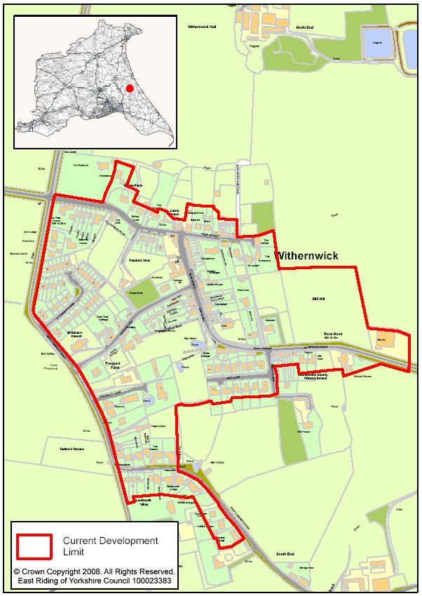
1 Settlement Profile of WITHERNWICK Copyright Paul Glazzard and licensed for reuse under this Creative Commons Licence (Attribution-Share Alike 2.0 Generic) Withernwick is a village 5 miles east of Skirlaugh on the Aldbrough to Skirlaugh road. The village is close to the attractive Lambwath Stream and surrounded by grade 2/3 agricultural land which is generally open and slightly undulating. Farmland around the village is mostly arable. The historic core of the village is on Main Street. Later development in the south of the village around Mill Lane and Church Lane has squared off the village form. The old part of the village has a number of terraced housing and small cottages that provide distinctive character. The eastern boundary of the village is marked by a light industrial unit and a primary school.
2 Demographics Please note that all figures marked with a * are taken from the 2001 Census. They should be treated with a degree of caution as they are a number of years old. However, the Census remains the best dataset available for consistent and robust comparisons of small areas. 1 Population: ,113* 52,041,916* (0.1% of East Riding total)* 2 Ages (16.9%)* (18.8%)* (20.2%)* 3 Ages (8.0%)* (9.1%)* (10.9%)* 4 Ages (23.6%)* (26.2%)* (29.2%)* 5 Ages (35.2%)* (27.5%)* (23.8%)* 6 Ages (16.2%)* (18.4%)* (16.0%)* Employment and Economic 7 Economically Active - Employed (proportion of residents aged 16 to 74): 8 Economically Active - Unemployed (proportion of residents aged 16 to 74): 9 Economically Inactive (proportion of residents aged 16 to 74): 210 (56.8%)* (61.5%)* (60.6%)* 13 (3.5%)* (3.0%)* (3.4%)* 142 (38.4%)* (33.3%)* (33.5%)* 10 Employed in manufacturing 23 (10.8%)* (16.4%)* (15.0%)* 11 Employed in education, health and 54 (25.5%)* (27.1%)* (24.3%)* public admin. 12 Employed in agriculture, hunting or 22 (10.4%)* (4.4%)* (1.5%)* forestry 13 Employed in retail, hotels and catering 45 (21.2%)* (21.6%)* (21.6%)* 14 Employed in financial and business 37 (17.5%)* (11.4%)* (17.7%)* services 15 Employed in transport, storage and 6 (2.8%)* (6.2%)* (7.0%)* communication 16 Employed in other 25 (11.8%)* (12.9%)* (12.9%)* 17 Managerial and professional 97 (26.2%)* (16.4%)* (15.0%)* occupations 18 Intermediate occupations 27 (7.3%)* (27.1%)* (24.3%)* 19 Small employers and own-account 48 (13.0%)* (4.4%)* (1.5%)* workers 20 Lower supervisory and technical 30 (8.1%)* (21.6%)* (21.6%)* occupations 21 Semi routine and routine occupations 51 (13.8%)* (11.4%)* (17.7%)* 22 Never worked and long-term 9 (2.4%)* (6.2%)* (7.0%)* unemployed 23 Not classified and full time students 108 (29.2%)* (12.9%)* (12.9%)* 24 Employment locations (including undeveloped allocations): 25 Number of jobs in parish 86* No major employment locations in the parish. Most jobs are in local services and facilities, agriculture or people working from home. Employment opportunities in Hornsea are within 7 miles. Further jobs on the edge of Hull and Beverley are within 9 and 13 miles respectively. Withernwick has a relatively low proportion of people employed in transport, storage and communication industries.
3 Households and Housing 26 Total number of dwellings: 209 (0.2% of East 136,537* 22,481,305* Riding total)* 27 Detached houses and bungalows 109 (51.4%)* (33.4%)* (22.8%)* 28 Semi-detached houses and bungalows 50 (23.6%)* (37.4%)* (31.6%)* 29 Terraced houses and bungalows 50 (23.6%)* (19.9%)* (26.0%)* 30 Flat/maisonette/apartment 0 (0.0%)* (8.8%)* (18.8%)* 31 Caravan/Temporary structure 0 (0.0%)* (0.4%)* (0.4%)* 32 Rented from local authority/rsl/ha 24 (11.9%)* (9.0%)* (13.2%)* 33 Private rented stock 21 (10.4%)* (1.6%)* (5.9%)* 34 Number of dwellings built between 8 9, & 2008 (financial year parish): 35 Outstanding commitments (01/04/08) 3 5,269 - (parish): 36 Capacity of outstanding allocations: WK1a Land west of Mill Lane Est. capacity: 12 (no permission) WK1c Land to the south west of White House, Beverley Road Est. capacity: 18 (outline consent granted for 3 dwellings) WK1e Land north of Aldbrough Road Est. capacity: 36 (no permission) WK2 Land north of Aldbrough Road Est. capacity: 19 (no permission) 37 Capacity identified in SHLAA: TBC TBC - 38 Identified housing need: 3 per annum 1,455 per annum - 39 Average house price (Jan-Dec 2007): 164,234 (HU11 4) 154, , Average house price change ( % 53.9% 39.5% 2007): 41 Housing market sub-area: Holderness Deprivation and Prosperity 42 Lowest ranked (least deprived) IMD SOA: 43 Highest ranked (most deprived) IMD SOA: At the time of the Census (2001), there were no records of flats, maisonettes or apartments in Withernwick. 23,303 32,397 32,482 (east part of (South Hunsley) Withernwick and includes Hatfield, Rise, Catwick and Long Riston) 16,141 (west part of Withernwick and includes Humbleton, Flinton, West Newton and northern part of Sproatley) 758 (Bridlington South) 44 Average household income: 30,082-41,271 33,168 X 45 Number of households without a car or 17 (8.4%)* (20.2%)* (26.8%)* van 46 Number of households with 1 car or 93 (46.0%)* (46.0%)* (43.8%)* vans 47 Number of households with 2 cars or 69 (34.2%)* (27.1%)* (23.6%)* vans 48 Number of households with 3 or more 23 (11.4%)* (6.6%)* (5.9%)* cars or vans 49 Regeneration Strategy category None 1
4 Withernwick is located within an area ranked amongst the 10% most deprived areas in the country as measured against access to housing and services (Barriers to Housing and Service Domain: Indices of Multiple Deprivation 2007). Services and Facilities 50 Shopping areas: No shopping area defined 51 Nearest supermarket: Londis & Spar (Aldbrough) approximately 3.5 miles Co-op (Hornsea) approximately 7 miles Asda (Bilton) approximately 8.5 miles Other Hull supermarkets approximately 9-12 miles 52 Retail hierarchy status: Not assessed 53 Markets: 54 Community services and facilities: (see also below) Falcon Inn Main Street AA Voase Butchers Main Street Withernwick Village Hall Main Street Withernwick Institute Main Street 55 Primary school(s): Withernwick does not have a primary school. Children generally attend Aldbrough Primary School 56 Nearest Secondary school(s): Hornsea School South Holderness Technology College 57 Capacity of schools: Aldbrough Primary School 186 (116 currently on roll 2007/08) Hornsea School 1,404 (1,263 currently on roll 2007/08) South Holderness Technology College 1,782 (1,810 currently on roll 2007/08) 58 Nearest college/sixth form: Hornsea School South Holderness Technology College 59 Health facilities: Hospitals Princess Royal Hospital 9 miles Nearest alternatives: Hornsea Cottage Hospital 7.5 miles Hull Royal Infirmary (A&E) 13.5 miles GP Surgeries Dr P I Collingwood and Partners, Cross Street, Aldbrough 3.5 miles Nearest alternatives: Eastgate Medical Group, Eastgate, Hornsea 7.5 miles Hedon Group Practice, Market Hill House, Hedon 12.5 miles Dental Practices Hornsea Dental Access Service, Cliff Road, Hornsea 7.5 miles Nearest alternatives: Dr A Dickson, Cliff Road, Hornsea 7.5 miles Dr H Cowley & Dr J Essam, High Stile, Leven 8.5 miles Pharmacies Lloyds Pharmacy, Market Place, Hornsea 7.5 miles Nearest alternatives: Stephen P Bowling Dispensing Chemist, Newbegin, Hornsea 7.5 miles Ba Whittle Chemists, Newbegin, Hornsea 7.5 miles 60 Leisure and cultural facilities: 61 Recreation areas: 63 Tourist facilities/accommodation: 64 Infrastructure capacity and constraints: Transport and Accessibility 65 Strategic highway access (any identified Approximately 5 miles from the A165 network constraints): 66 Rail network access: Nearest station: Hull 13 miles 67 Public transport provision (Bus): EYMS: 220, 230, 241, 920 (all limited services) 68 Distance by road to nearest Regional or Sub Regional City (time taken on public Hull 13 miles (1 hr 2 mins by bus change at Skirlaugh)
5 transport): 69 Distance by road to nearest Principal Town (time taken on public transport): Beverley 13.5 miles (1 hr 2 mins by bus change at Hornsea) 70 Average distance of travel to work 18.49* (11.5 miles) 17.75* (11 miles) 13.39* (8.3 miles) (km): 71 Travel to work by public transport 4 (1.9%)* (4.7%)* (14.5%)* 72 Travel to work by 177 (82.7%)* (69.5%)* (63.1%)* car/motorcycle/van/taxi 73 Travel to work by bicycle or on foot 10 (4.7%)* (14.8%)* (12.8%)* 74 People who mainly work from home 20 (9.3%)* (10.3%)* (9.2%)* 75 Travel to Work Area Hull* Environmental Issues 76 Flood risk: Withernwick village is within an area defined as Flood Zone 1 (low risk). In the events of June 2007, between 1 and 10 properties were recorded as being flooded in the parish. 77 National designations: There are three small SSSI designations south of the village along the southern boundary of the parish (parts of Lambwath Meadow). 78 Local designations: Lambwath Stream is a designated RIGS. 79 Landscape character: (please see the Landscape Character Assessment and Detailed Assessments for further information) 80 Quality of surrounding agricultural land: 81 Conservation areas: None 82 Identified brownfield sites suitable for TBC redevelopment General Landscape character designation: Central Holderness Open Farmland East Grade 2 (Best and most versatile) North, West, South Grade 3 Parish Plans, Local Views and Strategies Please note: The views and material referenced below have been included for information only and do not necessarily mean that they have the support of East Riding of Yorkshire Council Comments: Draft published: 27/08/2008 First published: 07/11/2008 Last updated: Change Log Row Change Origin Date 59 Health facilities destinations and journey distances revised Forward Planning 03/11/08
6
Site ref: AS06 Site Name or Address: Murreys Court, Agates Lane
 Site ref: AS06 Site Name or Address: Murreys Court, Agates Lane Proposed Land Use: Total Site Area (Ha): Housing 1.85 Ha Description: It is understood that the owner has no plans to dispose of the site
SOUTH EAST LINCOLNSHIRE LOCAL PLAN: HOUSING PAPER DONINGTON (JUNE 2016)
") SOUTH EAST LINCOLNSHIRE LOCAL PLAN: HOUSING PAPER DONINGTON (JUNE 2016) 1 DONINGTON S PLACE IN THE SPATIAL STRATEGY 1.1 Policy 2 of the South East Lincolnshire Local Plan 2011-2036 Draft for Public Consultation
SOUTH EAST LINCOLNSHIRE LOCAL PLAN: HOUSING PAPER DONINGTON (JUNE 2016) 1 DONINGTON S PLACE IN THE SPATIAL STRATEGY 1.1 Policy 2 of the South East Lincolnshire Local Plan 2011-2036 Draft for Public Consultation
WINCHESTER TOWN 3.1 LOCATION, CHARACTERISTICS & SETTING
 WINCHESTER TOWN 3.1 LOCATION, CHARACTERISTICS & SETTING 3.1.1 The area referred to by the City Council, as Winchester Town, consists of the Winchester Wards plus the adjoining built up areas of Badger
2. Spatial Portrait, Vision and Objectives
 VISION & OBJECTIVES 2. Spatial Portrait, Vision and Objectives Introduction 2.1 This section sets out the spatial portrait of Uttlesford, the vision we have for the future of the area and the objectives
Land at Fiddington Hill Nursery, Market Lavington
 Land at Fiddington Hill Nursery, Market Lavington Briefing Report for Market Lavington Parish Council Persimmon Homes (Wessex) April 2016 Background This brief report has been prepared following the Market
9 Pershore. Introduction. Pershore Abbey
 118 Introduction 9.1 The historic town of Pershore lies on the River Avon and has a population of 7,000 (2009 Mid-Term Population Estimates). The main areas of the town are centred on the Abbey, the bustling
Story Homes. Land at Thirsk Road, Kirklevington. An Introduction to Story Homes. Our Foundations. Commitment to Consultation.
 Story Homes An Introduction to Story Homes Founded by Fred Story in 1987, Story Homes has a long and successful reputation of building high quality and high specification homes. The family owned business
The Site. Welcome to the public exhibition for Boothferry Road, Hessle.
 LINDEN HOMES Welcome to the public exhibition for Boothferry Road, Hessle. We would like to hear your views about our proposals before we submit a planning application later this year. If there is anything
WELCOME GYPSY LANE. Wider Site Location plan. Proposals for the development of LAND OFF FOXLYDIATE LANE WEBHEATH. Proposals for the development of
 WELCOME The developers are preparing an outline planning application for a residential led development and need the community s views in order to develop the proposals further WHAT IS PROPOSED? A high
Application Recommended for Approval Hapton with Park Ward
 Application Recommended for Approval Hapton with Park Ward APP/2017/0036 Outline Planning Application Outline application for the construction of a new 3 bedroom dwelling (with all matters reserved for
Evesham 7. Reasoned Justification
 95 Reasoned Justification 7.1 Evesham is situated within the Vale of Evesham and has an estimated population of 22,800 (2009 Mid-Term Population Estimates). As a main town it provides a wide range of services
Former North Works, Lickey Road, Longbridge, Birmingham
 Committee Date: 14/11/2013 Application Number: 2013/06431/PA Accepted: 27/08/2013 Application Type: Full Planning Target Date: 26/11/2013 Ward: Longbridge Former North Works, Lickey Road, Longbridge, Birmingham
Newcourt Masterplan. November Exeter Local Development Framework
 Newcourt Masterplan November 2010 Exeter Local Development Framework Background The Exeter Core Strategy Proposed Submission sets out the vision, objectives and strategy for the development of Exeter up
Key Principles. 290 Phasing Principles and Programme
 4 Phasing principles and programme 4c The aims of the phasing strategy are to satisfy planning policy requirements and create a sustainable, strong and healthy new community where, from the outset, people
OKEFORD FITZPAINE NEIGHBOURHOOD PLAN
 OKEFORD FITZPAINE NEIGHBOURHOOD PLAN Dear Parishioner, The Neighbourhood Plan Project Team have prepared this leaflet to summarise the full Neighbourhood Plan document. It provides a summary of the Vision,
About 10% of the Borough's population lives in the seven rural parishes. Population figures from the 1991 census are given below:-
 8. THE DISTRICT VILLAGES 8.1 Population About 10% of the Borough's population lives in the seven rural parishes. Population figures from the 1991 census are given below:- Village No. of Persons Cottingham
17. Coolaney-Rockfield Mini-Plan
 County Development Plan 2017-2023 Consolidated Draft + Adopted Amendments - August 2017 17. Coolaney-Rockfield Mini-Plan Village profile Coolaney is located approximately 23 km to the south-west of Sligo
28. Coolaney-Rockfield Mini-Plan
 28. Coolaney-Rockfield Mini-Plan 28. Coolaney-Rockfield Mini-Plan Community facilities Community facilities in Coolaney-Rockfield consist of a primary school, crèche, community centre, sports field and
WELCOME. Welcome and thank you for visiting today.
 WELCOME Welcome and thank you for visiting today. Bellway Homes Ltd (Yorkshire) are preparing a reserved matters planning application for a residential development of 293 homes at land North of Yew Tree
Rochford District Council Allocations Development Plan Document: Discussion and Consultation Document Sustainability Appraisal
 Option SWH1 Balanced Communities Option SWH1 1 To ensure the delivery of high quality sustainable communities where people want to live and work Will it ensure the phasing of infrastructure, including
an Inspector appointed by the Secretary of State for Communities and Local Government
 Appeal Decision Site visit made on 23 January 2017 by Gareth Wildgoose BSc (Hons) MSc MRTPI an Inspector appointed by the Secretary of State for Communities and Local Government Decision date: 6 February
Welcome to our public exhibition
 About Our Scheme Welcome to our public exhibition This exhibition gives you the chance to view and comment upon our emerging proposals for a new residential development of 68 new homes on the site of the
A Growing Community Rural Settlement Areas
 Town of Huntsville Official Plan Review - POLICY BACKGROUND PAPER A Growing Community Rural Settlement Areas BACKGROUND: In addition to the fully municipally-serviced Urban Settlement Area and the Hidden
35. Gorteen Mini-Plan
 35. Gorteen Mini-Plan 35. Gorteen Mini-Plan Community facilities Community facilities in Gorteen consist of a crèche, community centre, sports field, church, burial ground and health centre. The former
SITE ASSESSMENT CHECKLIST
 1. Site Details a. What is the site s name/reference? SITE ASSESSMENT CHECKLIST CR3NPWHY 3007 Gasometer Site Godstone Road CR3 0EG b. Where is the site located? Wyhteleafe; Godstone Road. Urban category1
Bradleys Both Parish Council
 Bradleys Both Parish Council Bradleys Both Housing Site Assessments April 2015 Contents 1.0 Introduction... 2 2.0 BR001 Health Lea and Land to Rear, Skipton Road... 2 3.0 BR002 Holly Tree House and Land
Colchester Northern Gateway Master Plan Vision Review Draft. July 2016
 Colchester Northern Gateway Master Plan Vision Review Draft July 2016 Contents Introduction 4 Context 8 Purpose of the Report 8 Strategic Position 9 Overview of the Process 11 2012 Master Plan Vision 12
Application and Proposals. Part 211
 Application and Proposals Part 211 Site Location and Context The application site comprises two distinct land parcels totalling some 135 hectares. The site is bisected eastwest by Churchlands Development.
Public Consultation. Land at Monks Farm, North Grove. Welcome
 Welcome Welcome to our public exhibition for development on Land at Monks Farm, orth Grove. Gallagher Estates and Gleeson Strategic Land are preparing an outline planning application for new homes, open
Site ref: AS11 Site Name or Address: Land South of Ermyn Way
 Site ref: AS11 Site Name or Address: Land South of Ermyn Way Proposed Land Use: Total Site Area (Ha): Residential 11.4 Ha Description: The site comprises an area to the south of Green Lane and Ermyn Way,
DEVELOPMENT MANAGEMENT REPORT
 ITEM A08-1 DEVELOPMENT MANAGEMENT REPORT TO: BY: DATE: DEVELOPMENT: SITE: WARD: APPLICATION: APPLICANT: Development Management Committee Development Manager Proposed live/work unit in connection with existing
LONGDEN VILLAGE DEVELOPMENT STATEMENT
 LONGDEN VILLAGE DEVELOPMENT STATEMENT 2017-2027 1 Longden Development Statement 2017-2027 15/01/18 1. Background 1.1 Longden Village Longden village is a very rural and traditional community first mentioned
WELCOME. Land North of STEVENAGE. We would like to thank you for attending our public exhibition today.
 WELCOME We would like to thank you for attending our public exhibition today. The purpose of this event is to share our proposals and hear your thoughts on our ideas. Members of the project team are on
Planning and Sustainability Statement
 Land adjacent to Manor Farm, Catterick Village Pallett Hill Sand and Gravel Co Ltd Proposed 10 new dwellings, (6 No market dwellings and 4 No affordable dwellings) with access, associated car parking and
CALA HO ME S WELCOME
 WELCOME Welcome to this public consultation event for our proposed residential development of 56 high quality homes on land to the north east of Station Road in Earls Colne. Thank you for taking the time
DEVELOPMENT MANAGEMENT REPORT
 ITEM A07-1 DEVELOPMENT MANAGEMENT REPORT TO: BY: Development Management Committee (South) Development Manager DATE: 21 June 2016 DEVELOPMENT: SITE: WARD: APPLICATION: APPLICANT: Outline application for
20. Ballysadare Mini-Plan
 20. Ballysadare Mini-Plan 20. Ballysadare Mini-Plan Community facilities Ballysadare has a wide range of community facilities: a primary school, St Mary s College (secondary school), a health centre, playing
Ashtead Neighbourhood Forum Site Assessment AS03 Lime Tree Lodge, Farm Lane. Site address: Lime Tree Lodge, Farm Lane. Proposed Land Use:
 Site ref: AS03 Site address: Lime Tree Lodge, Farm Lane Proposed Land Use: Total Site Area (Ha): Housing 1.25ha Description The site is located off Farm Lane at the junction with Park Lane. To the north
Annex B: SWDP Objectives mapped against Worcestershire SCS Objectives. Annex B: SWDP Objectives mapped against Worcestershire SCS Objectives
 Annex B: SWDP mapped against SCS Annex B: SWDP mapped against SCS in SCS Economic Success That Is Shared By All 1. A skilled prosperous economy 1. Development that focuses on improving A. Enhanced prosperity
Briefing Document of CNP. June 2017
 Cholsey Parish Council Cholsey Neighbourhood Plan Briefing Document of CNP June 2017 Cholsey Neighbourhood Plan Page! 1 of! 8 Cholsey Plan Briefing v1.4 Page Left Intentionally Blank Cholsey Neighbourhood
Kibworth Harcourt. Introduction. Introduction
 Introduction Introduction Welcome to this public exhibition on the proposals for the delivery of new homes on land at The Kibworths. The purpose of today s exhibition is to give you the opportunity to
Site Allocations. REG 107 Appendix 1 Part B. february 2014
 Site Allocations Proposed submission local plan REG 107 Appendix 1 Part B february 2014 site allocations overview map of proposed site allocations overview map to be inserted prior to consultation 2 site
ALLERTHORPE NEIGHBOURHOOD PLAN
 Allerthorpe s Neighbourhood Plan sets out a vision for the Parish for the next 15 years (2018 2033) that builds on and reflects the opinions and views of parish residents. VISION In 2033 Allerthorpe will
Built Up Area Boundary (BUAB)
") Parish Boundary Built Up Area Boundary (BUAB) Potential Sites Map not to scale DWELLING SIZE POLICY Residential developments must provide a mix of dwelling sizes (market and affordable) that reflect the
Parish Boundary Built Up Area Boundary (BUAB) Potential Sites Map not to scale DWELLING SIZE POLICY Residential developments must provide a mix of dwelling sizes (market and affordable) that reflect the
Site Reference: 14 Site Address: South of Garden Street, Mexborough Hierarchy Status: Principal Town Settlement:
 Site Reference: 14 Site Address: South of Garden Street, Mexborough Hierarchy Status: Principal Town Settlement: Mexborough Site Area (Ha.): 0.76 Representation: No Site Origin: UDP Urban Potential Site:
Neighbourhood Planning Site Assessment Pro-forma and Guide Version 2
 Neighbourhood Planning Site Assessment Pro-forma and Guide Version 2 September 2014 Site HNP 006 Land East of Stanbridge Road and North of Lower Road 1. Background information Site location and use Site
OUR AREA SECTION 02 I NEXT PAGE. 2.1 This section sets the scene in regard to the role of the Legacy Corporation and the baseline
 7 ADOPTED LOCAL PLAN SECTION 02 2.1 This section sets the scene in regard to the role of the Legacy Corporation and the baseline position of the Local Plan. It sets out the historical context and current
Welcome. Proposals for land at Smug Oak Lane BRICKET WOOD
 Proposals for land at Smug Oak Lane BRICKET WOOD Previous Linden Homes and Wates Developments scheme Welcome Welcome to Linden Homes and Wates Developments public exhibition. Working together as joint
Birmingham. Summer study!!
 Birmingham Summer study!! Urban Change in the UK - Birmingham - Part 1 Location / Facts - Birmingham is located in the centre of England - It is the 2nd largest city with a population of around 1 million
STATEMENT OF OBJECTION TO THE PROPOSED DEVELOPMENT OF LAND AT CHURCH CLIFF DRIVE FILEY
 STATEMENT OF OBJECTION TO THE PROPOSED DEVELOPMENT OF LAND AT CHURCH CLIFF DRIVE FILEY You will be aware that Scarborough borough council have adopted a new local plan that includes land at Church Cliff
Local Plan Committee
 Local Plan Committee 8 June 2015 Item 8 Report of Head of Commercial Services Author Chris Downes 01206 282476 Title Update on the new Local Plan Call for Sites process Wards affected All The Local Plan
Have your say WELCOME. Land off Mill Lane, Monks Risborough. Welcome
 01 WELCOME Welcome Gladman Developments Ltd have successfully invested in communities throughout the UK over the past 20 years, developing high quality and sustainable residential, commercial and industrial
Ashtead Neighbourhood Forum Site Assessment AS07 Old Chalk Pit, Pleasure Pit Road. Site ref: AS07 Site address: Old Chalk Pit, Pleasure Pit Road
 Site ref: AS07 Site address: Old Chalk Pit, Pleasure Pit Road Proposed Land Use: Total Site Area (Ha): Housing 0.7ha Description: The site was formally an old chalk pit that has been partially filled and
BORRISOKANE SETTLEMENT PLAN
 BORRISOKANE SETTLEMENT PLAN 1.0 General Introduction and Development Context Location Borrisokane is located 15km north of Nenagh on the N52. While the town is primarily residential, it acts as a market
INTRODUCTION. Land south of Bishopswood Lane, Tadley
 0 INTRODUCTION THE SITE Introduction Gladman Developments Ltd. has successfully invested in communities throughout the UK over the past 0 years, developing high quality and sustainable residential, commercial
London Bridge London Bridge Area Vision Map
 Area Vision Map Borough Market Southwark Cathedral NSP54 Hay s Galleria Key: NSP Site Allocations Greenspace Low Line Thames Path Cycle Network Primary Shopping Areas Borough High Street Tube Station NSP51
LAND USE MODEL UPDATE. Planning and Land Use Advisory Committee Meeting #2 September 4, 2014
 1 LAND USE MODEL UPDATE Planning and Land Use Advisory Committee Meeting #2 September 4, 2014 2 Presentation Outline Introduction and Recap Model Process Study Design Place Types Suitability Factors 3
Longbridge Town Centre Phase 2 Planning Application
 Longbridge Town Centre Phase 2 Planning Application Non-Technical Summary of the Environmental Statement December 2013 Introduction A full application for Planning Permission has been submitted to Birmingham
4-Town Comprehensive Plan DRAFT 7/30/07
 4-Town Comprehensive Plan DRAFT 7/30/07 Acknowledgements ning Committee Town of Harrisburg Norman Roof Randy Nicol Town of Martinsburg Terry Thisse Paul Kelly Town of Montague Jan Bagdanowicz Wendy Perry
13. London Bridge London Bridge Area Vision
 13. 13.1. Area Vision 13.1.1. is: A globally significant central London business district which is home to international business headquarters; Internationally renowned for its prominent riverfront location
PLANNING STATEMENT. Market House Market Place Kingston upon Thames KT1 1JS
 PLANNING STATEMENT To support planning and listed building consent applications for change of use from Class A1 shop and Class A3 cafe to Class A3 restaurant at: Market House Market Place Kingston upon
Chapter 3 Core Strategy
 Chapter 3 Core Strategy 3.0 Introduction The core strategy sets out how the development objectives in the Development Plan are consistent with the National Spatial Strategy and the Regional Planning Guidelines.
Repton Parish Neighbourhood Development Plan - Consultation March 2017
 Repton Parish Neighbourhood Development Plan - Consultation March 2017 25 replies Policy No Comments Response H1 Agree 22 Amend to include Milton Road & footpath but exclude above footpath. Neither agree
Great Hammerton Growth Area: Our Vision August Hammerton Growth Area Harrogate: Our Vision
 Great Hammerton Growth Area: Our Vision August 2015 Hammerton Growth Area Harrogate: Our Vision i Contents 1.0 Introduction 1 2.0 Our Vision 3 3.0 Principle of Development 5 4.0 Site Context 7 5.0 Townscape
Settlement Boundaries Methodology North Northumberland Coast Neighbourhood Plan (August 2016)
") Introduction This background paper sets out a methodology for the definition of settlement boundaries in the North Northumberland Coast Neighbourhood Plan. The neighbourhood plan is planning positively
Introduction This background paper sets out a methodology for the definition of settlement boundaries in the North Northumberland Coast Neighbourhood Plan. The neighbourhood plan is planning positively
HURSTPIERPOINT SAYERS COMMON PARISH COUNCIL
 HURSTPIERPOINT SAYERS COMMON PARISH OFFICE TRINITY ROAD HURSTPIERPOINT HASSOCKS WEST SUSSEX BN6 9UY TEL: 01273 833264 FAX: 01273 834976 E-MAIL: HURSTPIERPOINT.PC@BTINTERNET.COM WEB SITE: WWW.HURSTPIERPOINT-PC.ORG.UK
Welford-on-Avon Neighbourhood Plan Consultation Event Sunday, 6 April Your name Your address
 Welford-on-Avon Neighbourhood Plan Consultation Event Sunday, 6 April 2014 Your name Your email address Please either: - complete this feedback form and put it in the box before leaving the Memorial Hall
CLEVE PARK, THORNBURY
 CLEVE PARK, THORNBURY Community Planning Day Report Back Broadsheet February 206 A VISION FOR CLEVE PARK Over 0 local people attended the Cleve Park Community Planning Day at Armstrong Hall on Saturday
Core Strategy Settlement Classification. 0.61ha. For sale
 Coleford NDP site assessment 15 1 4 MARSHES LORDS HILL SITE ASSESSMENT FORM A: BASELINE INFORMATION Settlement Name Coleford Core Strategy Settlement Classification Town Site Name / Address Gross area
Form to Submit Land for Residential Evidence Gathering Shepway Strategic Housing Land Availability Assessment (SHLAA) Partial Review
 Partial Review") Form to Submit Land for Residential Evidence Gathering Shepway Strategic Housing Land Availability Assessment (SHLAA) Partial Review All organisations and individuals who wish to put forward land for consideration
Form to Submit Land for Residential Evidence Gathering Shepway Strategic Housing Land Availability Assessment (SHLAA) Partial Review All organisations and individuals who wish to put forward land for consideration
3. Neighbourhood Plans and Strategic Environmental Assessment
 1. Introduction This report sets out a draft Screening Determination for the Preston Parish Council s Neighbourhood Plan and has been prepared by rth Hertfordshire District Council. The purpose of the
Northern Territory Compact Urban Growth Policy
 Northern Territory Compact Urban Growth Policy A Reference Policy Document to clause 2.7 (Reference to Policy) of the NT Planning Scheme May 2015 Table of Contents 1 Policy Setting... 3 1.1 Context for
Seneca Meadows. Block 4 Locate office, technology, and medical development adjacent to I Screen views of garage structures from I-270.
 Seneca Meadows Seneca Meadows has an industrial park in its southern end and a mixed-use employment area planned for the north end. The district benefits from extensive I-270 visibility, stream valley
A BEAUTIFUL PLACE FOR LIVING
 A BEAUTIFUL PLACE FOR LIVING BEAULIEU: A PLACE FOR LIFE Beaulieu is a vibrant new district taking shape in Chelmsford, Essex; offering residents inspirational architecture and landscape. Developers Countryside
I615. Westgate Precinct
 I615. Westgate Precinct I615.1. Precinct Description The Westgate Precinct is located approximately 18km west of the Auckland city centre. There are seven Sub-precincts in the Westgate Precinct: Sub-precinct
Copyright Nigel Deeley and licensed for reuse under this Creative Commons Licence
 1 Copyright Nigel Deeley and licensed for reuse under this Creative Commons Licence Prepared by the Neighbourhood Plan Steering Group on behalf of Garway Parish Council with assistance from 2 Table of
Ward: West Wittering. Proposal Change of use from public highway pavement to residential garden use.
 Parish: West Wittering Ward: West Wittering WW/17/03295/FUL Proposal Change of use from public highway pavement to residential garden use. Site Izora 1 Watersedge Gardens West Wittering PO20 8RA Map Ref
Brampton. Secondary Plan. Review. Bram West. A New Direction in Planning & Public Consultation
 Brampton Bram West Secondary Plan Review A New Direction in Planning & Public Consultation Introduction The Bram West Secondary Plan Review offers an important opportunity for the community to define a
INTRODUCTION NORTH HEYBRIDGE GARDEN SUBURB
 INTRODUCTION This event is being hosted by the promoters of the proposed North Heybridge Garden Suburb who are working with Maldon District Council and other key stakeholders on the preparation of a comprehensive
1. Nantwich - Planning for a Sustainable Future
 1. Nantwich - Planning for a Sustainable Future Cheshire East Council is charged with preparing its Development Plan to guide housing and other growth over the period to 2030. The Council intends to publish
Introduction. Cannock Road, Stafford. Introduction. The Site. The Application. The Need for New Housing
 01 Introduction Introduction Developments Ltd have successfully invested in communities throughout the UK over the past 30 years, developing high quality and sustainable residential, commercial and industrial
What do you like about South Marston?
 What do you like about South Marston? What you have said so far: Strong and separate identity, distinct from Swindon Village character (Church, School, Green and Hall) Surrounding working countryside and
Droitwich Spa 6. Reasoned Justification
 87 Droitwich Spa 6 Reasoned Justification 6.1 Droitwich Spa is identified in the settlement hierarchy (Policy SWDP1) as a main town being the largest settlement in Wychavon District with an estimated population
Hampton Park North Littlehampton West Sussex
 North Littlehampton West Sussex SUMMARY Summary An opportunity to create a new community in West Sussex on the northern outskirts of Littlehampton with outstanding views across open countryside towards
DESIGN & ACCESS STATEMENT
 DESIGN & ACCESS STATEMENT January 2016 Contents Introduction section 1 Section 1 - Introduction Section 2 - Assessment Section 3 - Involvement Section 4 - Evaluation Section 5 - Design Section 6 - Layout
Reserved Matters application for a site that straddles the boundary between CBC and BBC
 BBC APPLICATION 15/02682/MAR NUMBER CBC APPLICATION CB/15/04294/RM NUMBER LOCATION Wixams Land at former storage depot, Bedford Road, Wilstead Bedfordshire PROPOSAL Reserved Matters Application for Strategic
Welcome. Site/11/04. Site/11/03. Proposed Site. 11,400 new homes needed in east Cambs
 Welcome Welcome to our consultation on our proposals for new homes on land north east of Soham Road, Fordham. Members of the project team are available to answer any questions you have and listen to feedback.
30. Riverstown Mini-Plan
 County Development Plan 2017-2023 Consolidated Draft + Adopted Amendments August 2017 Volume 2, Chapter 30 Riverstown Mini-Plan 30. Riverstown Mini-Plan Village profile Riverstown is located approximately
Dulwich Dulwich Area Vision Map
 Area Vision Map Greendale Playing Fields East Lordship Lane Peckham Rye Park Herne Hill North St Barnabas Church Friern Road Edward Alleyn Club Herne Hill Velodrome Picture Gallery Village/College Road
What is the Local Plan 2035?
 What is the Local Plan 2035? The Local Plan 2035 will set out how much growth and development there will be in Bedford Borough until 2035 in order to meet local needs. It will plan for the additional houses
INTRODUCTION. Land West of Main Road, Stanton Harcourt THE SITE. Why is the Site Suitable for Development?
 0 INTRODUCTION THE SITE Application Boundary Gladman Developments Ltd has successfully invested in communities throughout the UK over the past 0 years, developing high quality and sustainable residential,
Drrumconrratth Wrriitttten Sttattementt. Position in Settlement Hierarchy Village - Local centre for services and local enterprise development
 Drrumconrratth Wrriitttten Sttattementt Settlement Drumconrath Position in Settlement Hierarchy Village - Local centre for services and local enterprise development Position in Retail Strategy Level 4
6. Ballintogher Mini-Plan
 County Development Plan 2017-2023 Consolidated Draft + Adopted Amendments August 2017 Volume 2, Chapter 6 Ballintogher Mini-Plan 6. Ballintogher Mini-Plan Village profile Ballintogher is located approximately
Proposed Redevelopment of Hope Wharf
 Welcome to our exhibition Premier Inn Hotel Gym ek Cre d r tfo ep Project Site Lewisham Southwalk College D Lewisham Southwalk College Mumford s Mill d ch i nw ee Gr h Hig a Ro The Site Existing Site Fairview
Cookham Parish Council s Response to The Draft Local Borough Plan
 Cookham Parish Council s Response to The Draft Local Borough Plan As Agreed at the Planning Committee Meeting on 10 th January 2017. Designation of Poundfield as a Local Green Space The Parish Council
Camberwell Camberwell Area Vision Map
 Area Vision Map NSP23 Burgess Park Edmund Street NSP29 NSP30 NSP31 New Road Benhill Road NSP27 NSP33 Green Brunswick Park NSP22 station NSP24 Peckham Road NSP26 St Giles Church Lucas Gardens NSP28 NSP25
SECOND DRAFT ARMTHORPE NEIGHBOURHOOD DEVELOPMENT PLAN AUGUST 2014
 SECOND DRAFT ARMTHORPE NEIGHBOURHOOD DEVELOPMENT PLAN AUGUST 2014 ARMTHORPE NEIGHBOURHOOD DEVELOPMENT PLAN August 2014 Contents Copyright Armthorpe Parish Council 2014 Introduction... 4 Vision and Aims...
Rathmolyon Written Statement
 Settlement Rathmolyon Position in Settlement Hierarchy Village - Local centre for services and local enterprise development Position in Retail Strategy Fourth tier retail centre Population (2011) Census
Carterton Construction Ltd is bringing forward plans for up to 85 new family homes and extra care facilities on land east of Burford.
 Welcome Carterton Construction Ltd is bringing forward plans for up to 85 new family homes and extra care facilities on land east of. We are at the early stages of designing our proposals and have a number
Environment Agency Flood Risk Map for the Village of Bridge
 Environment Agency Flood Risk Map for the Village of Bridge December 2016 21 Objective F. Conserving and Enhancing the Natural Environment The National Planning Policy Framework states that the planning