Appendix A. Project Location and Preferred Alternative Figures
|
|
|
- Morgan Benson
- 5 years ago
- Views:
Transcription
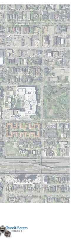
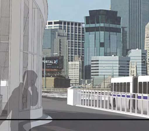
1 Appendix A Project Location and Preferred Alternative Figures Figure 1: Project Location Map Figure 2A: Preferred Alternative Layout Sheet 1 Figure 2B: Preferred Alternative Layout Sheet 2 Figure 2C: Preferred Alternative Layout Sheet 3 Figure 3: I-35W Proposed Changes Map Figure 4: Rendering of Proposed Lake Street Multimodal Transit Station (Freeway View) Figure 5: Rendering of Proposed Lake Street Multimodal Transit Station (Lake Street View) Figure 6: Rendering of Proposed Bridges at Lake Street Figure 7: I-35W Platform Level Design Elements Figure 8: Lake Street Level Design Elements Figure 9: Proposed Off-Street Trail Connection between Lake Street and Midtown Greenway Figure 10: Proposed Off-Street Trail Connection between Lake Street and 31 st Street Figure 11: 2 nd Avenue Preferred Alternative Map Figure 12: Rendering of Proposed 24 th Street Pedestrian Bridge Figure 13: I-94 Westbound Proposed Changes Map Figure 14: Noise Wall Analysis Summary Map For assistance with alternative formats for the Appendices, please contact Scott Pedersen at or scott.pedersen@state.mn.us.
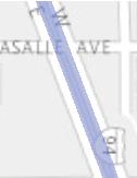
2 Existing Flyover Bridge Location Existing Braid Bridge Location FIGURE 1 - PROJECT LOCATION MAP


3 FIGURE 2A

4 FIGURE 2B


5 FIGURE 2C


6 SOUTHBOUND NORTHBOUND FIGURE 3 - I-35W PROPOSED CHANGES

7 FIGURE 4 - RENDERING OF PROPOSED LAKE STREET MULTIMODAL TRANSIT STATION (FREEWAY LEVEL)


8 FIGURE 5 - RENDERING OF PROPOSED LAKE STREET MULTIMODAL TRANSIT STATION (LAKE STREET VIEW)


9 BRIDGES AT LAKE STREET Looking East at North Plaza Looking North from South Plaza Existing Looking East along South side of Lake Street Looking East along North Sidewalk 7/16/2014 FIGURE 6 - RENDERINGS OF PROPOSED BRIDGES AT LAKE STREET


10 PLATFORM LEVEL - DESIGN ELEMENTS 7/16/2014 FIGURE 7 - I-35W PLATFORM LEVEL DESIGN ELEMENTS


11 LAKE STREET LEVEL - DESIGN ELEMENTS 7/16/2014 FIGURE 8 - LAKE STREET LEVEL DESIGN ELEMENTS


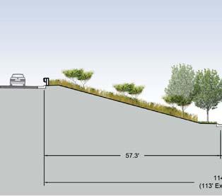
12 GREEN CRESCENT - PEDESTRIAN CONNECTION BETWEEN LAKE STREET AND MIDTOWN GREENWAY PEDESTRIAN/BICYCLE CONNECTION BETWEEN MIDTOWN GREENWAY AND LAKE STREET TRANSIT STATION I-35W I-35W I-35W SB Off-Ramp to Stevens Ave. Stevens Ave. Bridge SB Off-Ramp to Stevens Ave. Stevens Ave. 8.0' ' between freeway retaining wall and Stevens Ave. Bridge retaining wall Stairway from Stevens Ave. to Greenway Stevens Ave. SECTION A SECTION B SECTION C 2 ND AVENUE GREENWAY LEVEL PLAZA M IDTOWN GREENWAY STAIR CONNECTION BETWEEN GREENWAY & STEVENS AVENUE A 10 FOOT WIDE BIKE TRAIL 8 FOOT WIDE PEDESTRIAN TRAIL PEDESTRIAN CROSSING BETWEEN TRAILS TIERED RETAINING WALLS COLUMNAR OVERSTORY TREES I-35W RAISED CURB TO DISCOURAGE MIDBLOCK L AKE STREET I-35W Existing B CROSSING C A 1 B 1 C 1 S TEVENS AVENUE & 7/16/2014 FIGURE 9 - PROPOSED OFF-STREET TRAIL CONNECTION BETWEEN LAKE STREET AND MIDTOWN GREENWAY


13 BIKE CONNECTION BETWEEN LAKE AND 31ST ST Typical Section Existing Conditions Plan 7/16/2014 FIGURE 10 - PROPOSED OFF-STREET TRAIL CONNECTION BETWEEN LAKE STREET AND 31ST STREET


14 35W TRANSIT ACCESS PROJECT 2 ND AVENUE: ALTERNATIVE 3A Q P PLAN VIEW CROSS SECTION Q CROSS SECTION O O N CROSS SECTION P CROSS SECTION N 03/20/15 Figure 11-2nd Avenue Preferred Alternative Map


15 FIGURE 12 - RENDERING OF PROPOSED 24TH STREET PEDESTRIAN BRIDGE

16 FIGURE 13 - I-94 WESTBOUND PROPOSED CHANGES


17 Path: P:\FJ\H\Hennc\113114\GIS\data\Noise\FinalEA_Oct2015\Fig 16_NoiseWall_Public.mxd Lyndale See inset below for continuation of the project Area 12 Area 13 Wall wf Wall wh Wall wg Area 25 Area 14 Wall ei Proposed 20' Wall eh Area 20 Wall ne Wall se Proposed 15' Area 3 Wall eg Proposed 20' Wall ef Area 19 Steven's Square Loring Heights Wall wi Wall wj Area 2 Wall nd Proposed 20' Wall sd Whittier Area 15 Area 4 Loring Area 26 Wall wk Park Wall ej Wall wm Area 5 Wall wl1 Wall ek Central Area 16 Wall wl2 Wall nf Area 18 Area 17 Phillips West Area 21 Area 6 Wall el1 Wall el2 Area 7 Wall em INSET Area 8 Wall ng Wall sh Wall nh Area 27 King Area 22 Lyndale Field Wall wb Proposed 20' Area 9 Area 10 Wall wd Wall ni Wall wf Wall we Area 12 Area 11 Wall si Area 28 Ventura Village Area 1 Wall ee Area 2 Esri, HERE, DeLorme, MapmyIndia, OpenStreetMap contributors, and the GIS user community Area 23 Area 24 Wall ef Central Bryant Elliot Park Wall sj Proposed 20' Wall nj Proposed 20' Area 29 Esri, HERE, DeLorme, Map I Miles Print Date: 10/6/2015 Map by: MSS Projection: Hennepin County Coordinates Source: Hennepin County, BING City of Minneapolis, SEH Not Proposed Replace Proposed Existing Noise Wall (UPA / Crosstown Project) Proposed Geometrics Noise Wall Analysis Summary I-35W Transit Access Project Minneapolis, MN Figure 1 This map is neither a legally recorded map nor a survey map and is not intended to be used as one. This map is a compilation of records, information, and data gathered from various sources listed on this map and is to be used for reference purposes only. SEH does not warrant that the Geographic Information System (GIS) Data used to prepare this map are error free, and SEH does not represent that the GIS Data can be used for navigational, tracking, or any other purpose requiring exacting measurement of distance or direction or precision in the depiction of geographic features. The user of this map acknowledges that SEH shall not be liable for any damages which arise out of the user's access or use of data provided.
MEETING NOTES PROJECT ADVISORY COMMITTEE (PAC) May 26, :30 10:30 a.m. Colin Powell Center th Avenue South, Minneapolis
 May 26, :30 10:30 a.m. Colin Powell Center th Avenue South, Minneapolis") MEETING NOTES PROJECT ADVISORY COMMITTEE (PAC) May 26, 2011 8:30 10:30 a.m. Colin Powell Center 2924 4 th Avenue South, Minneapolis Meeting Attendance: See Attachment 1 1. Introductions Lisa Vecoli, Chair,
MEETING NOTES PROJECT ADVISORY COMMITTEE (PAC) May 26, 2011 8:30 10:30 a.m. Colin Powell Center 2924 4 th Avenue South, Minneapolis Meeting Attendance: See Attachment 1 1. Introductions Lisa Vecoli, Chair,
Pedestrian Annual Count Report
 Pedestrian Annual Count Report 2016 Table of contents Contents Overview 1 Materials and methodology 5 Results 10 Appendix A 13 Contact Information Jordan Kocak, Pedestrian and Bicycle Coordinator Jordan.Kocak@hennepin.us
Information for File # ARC
 Information for File # 2017-00054-ARC Applicant Consultant Corps Contact Linda Keith City of Tower Natalie White SEH Inc. Andrew R Chambers Address 600 South Lake Avenue, Suite 211, Duluth, MN 55802 E-Mail
V. Case Study Sites. Case Study Site Descriptions and Concepts. Case Study #1: Lake Street and Calhoun
 V. Case Study Sites The project area includes a wide variety of neighborhood contexts with diverse development opportunities. To better understand these contexts and how they affect choices concerning
Watertown City Council
 City of Watertown Watertown City Council April 14 th, 2015 Agenda Item: City Comment on Sun Share CUP Application Request for Action: Motion to Approve City Comments regarding CUP Application Department:
Corridor Vision. 1Pursue Minnehaha-Hiawatha Community Works Project. Mission of Hennepin County Community Works Program
 1Pursue Minnehaha-Hiawatha Community Works Project Minnehaha-Hiawatha Community Works is a project within the Hennepin Community Works (HCW) program. The mission of the HCW program is to enhance how the
the west loop HOME TO 5,000 NEW DOGS
 the west loop the west loop HOME TO 5,000 NEW DOGS the west loop HOME TO 5,000 NEW DOGS AND 20,000 NEW RESIDENTS outline: the west loop now the vision how do we get there? opportunity LEVERAGE TRANSIT
Midtown Greenway to lake street
 Making the connection: Midtown Greenway to lake street May 2016 Design experiment: site amenities, wayfinding, and activities at Cepro, near the Midtown Global Market Recent Greenway Development Highlights
Coast & Creek Cleanup Cordelia American Canyon Creek
 Rodriguez High School Oakbrook Dr. & Silverado Dr. G:\EnvironmentalComplaince\..\SiteMap_LowerUnionCreek.mxd Cordelia American Canyon Creek Scandia Dan Wilson Creek Subway End of Lookout Hill Rd. off Central
In November and December, SACOG staff conducted the following Blueprint Implementation land use activities:
 SACOG Board of Directors Item #18-1-16 Receive & File January 11, 2018 Blueprint Implementation Activities The purpose of this item is to regularly inform the Board of SACOG land use related activities
The University District envisions, in its neighborhood
 Envisioning the University District Link Light Rail in Seattle s neighborhoods CIY OF SEALE CONCEP-LEVEL SAION AREA PLANNING RECOMMENDAION RESOLUION # 30165 EXHIBI L Vision 08.2000 he University District
ARGENTA TRAIL (CSAH 28/63) REALIGNMENT SOUTH PROJECT (CP 63-25)
 REALIGNMENT SOUTH PROJECT (CP 63-25)") ARGENTA TRAIL (CSAH 28/63) REALIGNMENT SOUTH PROJECT (CP 63-25) Preliminary Design Report February 2015 Prepared For: City of Inver Grove Heights Dakota County Prepared By: Kimley-Horn and Associates,
ARGENTA TRAIL (CSAH 28/63) REALIGNMENT SOUTH PROJECT (CP 63-25) Preliminary Design Report February 2015 Prepared For: City of Inver Grove Heights Dakota County Prepared By: Kimley-Horn and Associates,
Midtown Corridor Alternatives Analysis. Appendix A - Initially Considered Alternatives Screening
 Midtown Corridor Alternatives Analysis Appendix A - Initially Considered Alternatives Screening Arterial BRT on Lake Street - Overall Rating: RATING Metropolitan Council recommendations stated in the Transportation
CITY OF BOYNTON BEACH SE 1 ST STREET COMPLETE STREETS IMPROVEMENTS
 CITY OF BOYNTON BEACH SE 1 ST STREET COMPLETE STREETS IMPROVEMENTS N Project Location -Town Square -Villages at Ocean SE 1st St, between E Woolbright Rd and SE 2nd Ave Project Location -Boynton One -Publix
4 Circulation. Master Plan Recommendations: Access and
 45 4 Circulation Master Plan Recommendations: Access and 46 Chapter 4 MASTER PLAN RECOMMENDATIONS: Access and Circulation Access and Circulation Lake Calhoun/Bde Maka Ska and Lake Harriet are heavily used
Land Use and Urban Design...
 Land Use and Urban Design... 6 Land Use and Urban Design The interaction between transportation and land use is an established principle of urban design. Good urban design of both public and private property
Blue Line LRT Extension
 v e Noble Pkwy Noble Pkwy Xerxes Ave N Shingle Creek Penn Ave N Penn Ave N Fremont Ave N Lyndale Ave N S Washington Ave University Ave NE Blue Line LRT Extension LIGHT RAIL PLATFORM AND STATION DESIGN
4 Park Planning and Design
 4 Park Planning and Design Park Constellations Elliot Gateway/Mills Loring North Loop Commons Twins Minneapolis Park & Recreation Board Downtown Service Area Master Plan 4-1 PROJECT APPROACH REFERENCE
Community Engagement Committee Meeting #1 December 10, :30pm-8:30pm
 Community Engagement Committee Meeting #1 December 10, 2014 6:30pm-8:30pm Welcome and Introductions Dana Murdoch Minneapolis Park and Recreation Board Project Manager Ryan French Walker Art Center Director
Corridor Background. Defining the Corridor Study Area. Lake Street. 38th Street. 46th Street
 1 Corridor Background Defining the Corridor Study Area Minnehaha Avenue (CSAH 48) and Hiawatha Avenue (MN 55) are parallel diagonal roadways, approximately three blocks apart, that provide two direct arterial
Anderson Memorial Bridge Rehabilitation Project Boston/Cambridge
 Anderson Memorial Bridge Rehabilitation Project Boston/Cambridge MEPA Meeting, EEA#14702 Wednesday, March 2, 2011 6:30 PM Dr. Martin Luther King, Jr. School 100 Putnam Avenue, Cambridge, MA Rendering by:
September 28, 2017 Wentworth Avenue (CR 8) Sidewalk Improvements Open House
 Sidewalk Improvements Open House") TIME Anytime from 5:00 PM to 7:00 PM LOCATION City Hall Council Chambers Learn about the project Speak with project representatives Provide input YOU RE INVITED! September 28, 2017 Wentworth Avenue (CR
TIME Anytime from 5:00 PM to 7:00 PM LOCATION City Hall Council Chambers Learn about the project Speak with project representatives Provide input YOU RE INVITED! September 28, 2017 Wentworth Avenue (CR
Northwest Rail Corridor and US 36 BRT Development Oriented Transit Analysis 4.4 STATION AREA FINDINGS
 4.4 STATION AREA FINDINGS Each station is different, and each one requires a separate set of recommendations based on the vision for the site. This section outlines an initial TOD strategy and recommendations
Midtown Greenway Land Use and Development Plan Executive Summary
 Midtown Greenway Land Use and Development Plan Executive Summary Introduction The Midtown Greenway Land Use and Development Plan sets policy direction for land use and development in the Midtown Greenway
PARK & PORTLAND: VISION FOR DEVELOPMENT
 2025 PLAN EAST TOWN DEVELOPMENT GROUP East Town is a thriving district of 120 square blocks (300 acres) in the most accessible and visible sector of Downtown Minneapolis. It is bounded by the Minneapolis
November 2, 2015 at 5:15pm City Council Chambers, 3rd Floor, City Hall, 1737 Main Street Columbia, South Carolina 29201
 Subject Property: PLANNING COMMISSION SITE/SUBDIVISION PLAN CASE SUMMARY 10.21 ACRES, WESTSIDE OF CLIF KINDER BOULEVARD COTTAGES AT BURNSIDE FARM BURNSIDE FARMS ASSOCIATES, LLC November 2, 2015 at 5:15pm
LEGEND. Existing Transit Services in Project Area. I-84 / I-91 INTERCHANGE STUDY I-84 / I-91 Transit Map. Connecticut Department of Transportation
 I-84 / I-91 INTERCHANGE STUDY Basemap 91 Je Alb nn ing sr d Ea st Ha r t for d H ar tfor d H a r t fo r d r t fo r d We s t H a. 5 a ny Av e. FD Oat es Ave. Pa r k. Ave 44 44 A sy lum Av e. Bulkeley Bridge
List of Priority Projects
 List of Priority Projects Fiscal Years 2017-18 to 2021-22 June 27, 2016 Draft Metropolitan Transportation Planning Organization for the Gainesville Urbanized Area List of Priority Projects Fiscal Years
5. Father Hennepin Blufs Park and Hennepin Island Father Hennepin Bluffs Park Supporting Initiatives (see Figure 36): 7-22
: 7-22") 5. Father Hennepin Blufs Park and Hennepin Island As described in existing conditions portion of Chapter 2, Father Hennepin Blufs Park lies on the upland portion of the park and Hennepin Island spans the
5. Father Hennepin Blufs Park and Hennepin Island As described in existing conditions portion of Chapter 2, Father Hennepin Blufs Park lies on the upland portion of the park and Hennepin Island spans the
Description of Preferred Alternative
 Chapter 2 Description of Preferred Alternative 2.1 Introduction This chapter of the programmatic Sammamish Town Center Sub-area Plan Final EIS provides a more detailed description of the Preferred Alternative
North Macadam Transportation Development Strategy Summary of Past Studies DRAFT
 North Macadam Transportation Development Strategy Summary of Past Studies DRAFT Several previous studies were reviewed to gain an understanding and document the recent transportation issues in the North
#27. Timing: Short term. Costs: $$
 Land Use & Physical Resources PROJECT #27 Mobility S t u d y a n d i m p l e m e n t H i a w a t h a A v e n u e / M N 5 5 traffic signal improvements Environment & Natural Resources Economic Development
Mavis Road Class Environmental Assessment
 Mavis Road Class Environmental Assessment Public Information Centre #2 Wednesday November 9, 2016 6:00 to 8:00 p.m. Please sign in and complete a comment sheet Review the displays on your own or join in
APPENDIX D: Visual and Aesthetic Conditions for NCCU Station Refinement. Durham-Orange Light Rail Transit Project
 APPENDIX D: Visual and Aesthetic Conditions for NCCU Station Refinement Durham-Orange Light Rail Transit Project October 2016 1. Introduction The Combined FEIS/ROD summarizes the effects of the D-O LRT
Application for Abandonment
 Application for Abandonment Of 6 th Street Alley Abandonment Prepared For: University Housing Group, Inc. 2770 Electric Road SW, Suite C Roanoke, VA 24018 Prepared By: KRATER CONSULTING Group A Nevada
Infrastructure Engineering Planning Construction Suite 300 Minneapolis, MN Tel: Fax:
 Infrastructure Engineering Planning Construction 701 Xenia Avenue outh uite 300 Minneapolis, MN 55416 Tel: 763-541-4800 Fax: 763-541-1700 Memorandum To: Minnehaha Creek Watershed District Board From: Tony
Wallace Country Acreage
 Wallace Country Acreage A stunning brick home surrounded by beautiful landscaping and picturesque views of the Nebraska plains Email: Jordan@lashleyland.com Property Highlights List Price $500,000 Location
OVERLAKE VILLAGE STATION
 OVERLAKE VILLAGE STATION Today NEIGHBORHOOD CONTEXT PLAN NEIGHBORHOOD CONTEXT PLAN WITH DEVELOPMENT 148TH AVE NE 1/4-MILE RADIUS NE 36TH ST BUS ROUTE BICYCLE ROUTE S.R. 520 NE 31TH ST PEDESTRIAN-BICYCLE
Chapter 8. Visualizations
 Examples of Effective Techniques for Improving the Quality of Environmental Documents Chapter 8. Visualizations Visualizations help the reader to see what the project would look like in the real world.
Environmental Critical Issues Report
 Environmental Critical Issues Report May 25, 2018 DRAFT Deliverable Task 9.1 Prepared for: Prepared by: Historical Research Associates, Inc. Blank Page Pacific Avenue SR 7 Corridor HCT Feasibility Study
Access to the University of North Carolina at Chapel Hill, UNC Hospitals, and Chapel Hill Transit.
 M 1/ 4 1/ 2 E IL M E IL Station Family: County: City: UNC Hospitals WHY THIS STATION? University Village Orange Chapel Hill Access to the University of North Carolina at Chapel Hill, UNC Hospitals, and
ROBBINSDALE LRT STATION CDI DEVELOPMENT GUIDELINES
 August 2018 OVERVIEW The City of Robbinsdale has a prime-opportunity site in the middle of the 13 mile stretch of the Bottineau LRT corridor / Blue Line extension. Robbinsdale offers a prominent, vital,
Community Working Group Workshops - Workshop Summary September TOD Corridor Strategy and Access Planning Study. Workshop Introduction
 Community Working Group Workshops - Workshop Summary September 11-13 2018 TOD Corridor Strategy and Access Planning Study With VTA s BART Phase II (the Study), VTA seeks to build upon existing transportation
PROPOSED IMPROVEMENTS
 IV. PROPOSED IMPROVEMENTS The proposed improvements for each alternative carried forward are discussed below. A. FUNCTIONAL CLASSIFICATION AND ROADWAY CROSS-SECTIONS The classifications of the roadways
Figure 6. Bridge 9 Replacement Concept. Central Corridor LRT Northern Alignment Alternative. University of Minnesota 4/21/2008
 699 4/21/2 Bridge 9 Replacement Concept Northern Alignment Alternative University of Minnesota Figure 6 support/699 LRT U of M Northern Alignment/Report-Feasibility Study/699 figures.qxd Washington Avenue
June 14, 2017 for the June 20, 2017 Parks and Trails Commission Meeting
 105 South Fifth Avenue Suite 513 Minneapolis, MN 55401 Tel: 612-252-9070 Fax: 612-252-9077 www.landform.net TO: FROM: DATE: Corcoran Parks and Trails Commission Kendra Lindahl, Landform June 14, 2017 for
Goals AND Guiding principles
 Historic photo of Eastlake Train Station sign Chapter 2: Goals AND Guiding principles 2-1 The Plan goals includes a desire to bridge present day conditions with a vision of the area s future. A central
REVIEW SET ONLY - NOT FOR BIDDING
 LOCATION SHEET A.02 LOCATION SHEET A.03 LOCATION SHEET A.04 Grade Break Special Shaping Parking Perpendicular Curb Ramp Slope: 6.25% (target) 8.3% (max) 3 Special Shaping Existing Sidewalk Parallel Curb
BeltLine Corridor Environmental Study
 BeltLine Corridor Environmental Study Citywide Conversation on Transit and Trails April 2, 2009 Agenda & Introductions Introductions Environmental Study Process Overview of the BeltLine Project BeltLine
SYSTEM EXPANSION. Sound Transit system expansion will:
 SYSTEM EXPANSION Sound Transit system expansion will: Expand Sounder south line capacity and service, including longer trains (to accommodate 40 percent more passengers) and the potential for more daily
Welcome! Community Meeting FOR YOUR NEW WEBBER PARK LIBRARY
 Community Meeting FOR YOUR NEW WEBBER PARK LIBRARY Tuesday, April 21, 6 p.m. to 7:30 p.m. Webber Community Center Multipurpose Room 4400 Dupont Ave. N., Minneapolis, MN 55412 Welcome! Please join Hennepin
22a. Existing Condition. 22b. Simulation of NE 20th Street Alternative (D3)
") Appendix F4.5 Visual Consistency and Key Observation Point Analyses EXHIBIT F4.5-22 Key Observation Point 22 (looking east along NE 20th Street) 22a. Existing Condition 22b. Simulation of NE 20th Street
Appendix F4.5 Visual Consistency and Key Observation Point Analyses EXHIBIT F4.5-22 Key Observation Point 22 (looking east along NE 20th Street) 22a. Existing Condition 22b. Simulation of NE 20th Street
Preliminary Construction & Traffic Planning Intro to Shop Local/Shop Eglinton Initiative. June 27, 2012
 Preliminary Construction & Traffic Planning Intro to Shop Local/Shop Eglinton Initiative June 27, 2012 Agenda Introductions Project Update Preliminary Crosstown Construction & Traffic Planning Overview
Key Moves in the Plan
 Key Moves in the Plan 2 Add housing that fits the neighbourhood s character Make it easier to leave the car behind Oak Bay Avenue Village plan to be completed in future planning process Future active transportation
REDLANDS TRANSIT VILLAGES SPECIFIC PLAN
 REDLANDS TRANSIT VILLAGES SPECIFIC PLAN CITY COUNCIL STUDY SESSION JANUARY 4, 2019 Redlands Blvd. Eureka St. Orange St. State St. Citrus Ave. Vine St. GENERAL PLAN TRANSIT VILLAGES WE ARE HERE SPECIFIC
QUESTION 8: What are your Public Realm priorities for implementation? What would you like to see happen first? TELL US WHAT YOU THINK
 Public Realm Plan How will the Public Realm Plan be implemented? The Public Realm Plan document will set out a vision for the next 30 years. Over time, Plan elements and aspects can be implemented as opportunities
Build on community input
 Build on community input 1/8 8 WAYS TO CREATE GREAT PLACES Employ effective facilitation to encourage broad participation, deliver an aligned vision, and realize neighborhood plans. On front: Planning
District of Columbia Fiscal Year Statewide Transportation Improvement Program. Draft Project List September 2017
 District of Columbia Fiscal Year 2018 2022 Statewide Transportation Improvement Program Draft Project List September 2017 Ward 1 Projects ID Project Name and Description Project Category 22 Florida Ave
JOINT PUBLIC NOTICE. 26 June United States Army Corps of Engineers State of Louisiana
 JOINT PUBLIC NOTICE 26 June 2017 United States Army Corps of Engineers State of Louisiana New Orleans District Department of Environmental Quality Regulatory Branch Office of Environmental Services 7400
Port of Seattle Street Vacations Summary April, 2016
 Port of Seattle Street Vacations Summary April, 2016 Since the question of street vacations provided to the Port was raised at the April 19 Sustainability and Transportation Committee, the Port is providing
I-90 ALLSTON INTERCHANGE A MULTIMODAL TRANSPORTATION PROJECT PUBLIC INFORMATION MEETING SEPTEMBER 18, 2014 JACKSON MANN COMMUNITY CENTER
 I-90 ALLSTON INTERCHANGE A MULTIMODAL TRANSPORTATION PROJECT PUBLIC INFORMATION MEETING SEPTEMBER 18, 2014 JACKSON MANN COMMUNITY CENTER 1 Project Need Deteriorating viaduct requiring replacement All Electronic
What s Up Next In The Seattle Squeeze. PSRC Transportation Policy Board April 11
 What s Up Next In The Seattle Squeeze PSRC Transportation Policy Board April 11 1 Current construction Alaskan Way Viaduct removal Removes the viaduct (including foundations and ramps) and restores the
Eastside Transit Corridor Phase 2 Technical Study Update Community Outreach Meeting February 2017
 Eastside Transit Corridor Phase 2 Technical Study Update Community Outreach Meeting February 2017 Purpose of Tonight s Meeting Recap of Board motion (2014) and technical study process Provide update on
Potential Funding Sources: Mn DNR Local Trail Connections Grant City of Minneapolis CIP Hennepin County CIP
 Land Use & Physical Resources PROJECT #33 Mobility B u i l d a b i k e / p e d e s t r i a n c o n n e c t i o n b e t w e e n L a k e S t L R T s t a t i o n a n d M i d t o w n G r e e n w a y on east
Midtown Greenway PROJECT REPORT CARD
 Midtown Greenway PROJECT REPORT CARD Project Overview and History The Midtown Greenway is a 5.5-mile multi-use trail that connects the Mississippi River to the Minneapolis Chain of Lakes. The corridor,
EAST SACRAMENTO COMMUNITY PLAN
 EAST SACRAMENTO COMMUNITY PLAN Part Three : COMMUNITY PLAN AREAS AND SPECIAL STUDY AREAS CONTENTS Community Location...3-ES-3 Community Vision...3-ES-4 Community Profile...3-ES-4 Community Issues...3-ES-5
Queen St E & Leslie St Noise Analysis Toronto, Ontario. Toronto Transit Commission Streetcar Department 1900 Yonge Street Toronto, ON M4S 1Z2
 ASSESSMENT REPORT - Project: 151.08 Queen St E & Leslie St Noise Analysis Toronto, Ontario Prepared for: Toronto Transit Commission Streetcar Department 1900 Yonge Street Toronto, ON M4S 1Z2 Prepared by:
The Atlanta BeltLine. Quarterly Briefing March @atlantabeltline. Reynoldstown Senior Affordable Housing
 The Atlanta BeltLine Quarterly Briefing March 30, 2017 @atlantabeltline @atlantabeltline @atlantabeltline Reynoldstown Senior Affordable Housing Framework for a multi-use and transit corridor in the heart
.404 acres (approximately 17,600 square feet) Existing Zoning
 Existing Zoning") COMMUNITY DEVELOPMENT DEPARTMENT Planning and Zoning Division 1725 Reynolds Street, Suite 200, Brunswick, GA 31520 Phone: 912-554-7428/Fax: 1-888-252-3726 BOARD OF COMMISSIONERS STAFF REPORT October 25,
COMMUNITY DEVELOPMENT DEPARTMENT Planning and Zoning Division 1725 Reynolds Street, Suite 200, Brunswick, GA 31520 Phone: 912-554-7428/Fax: 1-888-252-3726 BOARD OF COMMISSIONERS STAFF REPORT October 25,
Public input has been an important part of the plan development process.
 Lakewood s Comprehensive Plan recognizes that transportation helps shape the community, and that the way the community provides for the safe and efficient movement of people affects the character of the
MONTGOMERY COUNTY PLANNING DEPARTMENT THE MARYLAND-NATIONAL CAPITAL PARK AND PLANNING COMMISSION
 MONTGOMERY COUNTY PLANNING DEPARTMENT THE MARYLAND-NATIONAL CAPITAL PARK AND PLANNING COMMISSION MCPB Item No. 7 Date: 2-28-13 Purple Line Briefing David Anspacher, Senior Planner, david.anspacher@montgomeryplanning.org,
Information for File # MHK
 Information for File #2014-03555-MHK Applicant: Corps Contact: Wimmer Communities Marie Kopka Address: 250 N. Sunnyslope Road, Suite 296 Brookfield, Wisconsin 53005 E-Mail: Marie.H.Kopka@usace.army.mil
APPENDIX C Discipline Report Errata Sheets. Final Environmental Impact Statement Alaskan Way, Promenade, and Overlook Walk
 APPENDIX C Discipline Report Errata Sheets Final Environmental Impact Statement Alaskan Way, Promenade, and Overlook Walk October 2016 Alaskan Way, Promenade, and Overlook Walk Final Environmental Impact
WELCOME! MINNEHAHA-HIAWATHA Community Works Project. 46th Street Area Lighting Project July 2009
 WELCOME! MINNEHAHA-HIAWATHA Community Works Project 46th Street Area Lighting Project July 2009 Partners The 46th Street Lighting project is a collaboration between Hennepin County and: The City of Minneapolis
Exhibit A. SH 161 RTC Work Program of New Projects. Collin County
 Exhibit A SH 161 RTC Work Program of New Projects Collin County 0918-24-969 N/A 0918-24-970 N/A 0918-24-973 N/A 2351-01-020 N/A 2679-03-010 N/A On Exchange Parkway from US 75 to Allen Heights On Country
I-95 Girard Avenue Interchange Near Neighbors Meeting. Project Status
 I-95 Girard Avenue Interchange Project Status Construction is underway for Phase 1 and 2. Phase 3 construction will begin early 2014. Overall Project Area and Schedule GR0: Completed GR0: Completed in
Meeting Purpose: Date and Time: Location: Attendance: Handouts:
 Meeting Purpose: Date and Time: Location: Attendance: Handouts: PA Turnpike / I-95 Interchange Project Design Advisory Committee (DAC)/Public Officials Meeting #8 April 12, 2012 at 1:30 p.m. Project Office,
Transportation. Strategies for Action
 Transportation A major priority for the Overlake Neighborhood is to develop a multimodal transportation system. To achieve this system, a balance has to be found among travel, circulation and access needs;
Attachment A Description of Project
 Attachment A Description of Project Arkansas River Flood Levee Trail and Multimodal Connections This application requests funding in 2018 to assist with the construction of the improvements including 1,200'
Information for File # MVP MMJ; Elim Care
 Information for File # MVP-217-2628-MMJ; Elim Care Applicant: Elim Care of Maple Plain Corps Contact: Melissa Jenny Address: 18 Fifth Street East, Suite 7, St. Paul, MN 5511-168 E-Mail: Melissa.m.jenny@usace.army.mil
SH 199 Corridor Master Plan. Community Meeting No. 2 May 31, 2017
 Community Meeting No. 2 May 31, 2017 Transportation Projects On or Near SH 199 SH 199 from 0.3 miles south of FM 1886 to south end of Lake Worth bridge Construct freeway mainlanes and frontage roads 10-Year
Urban Design 9Identity
 Urban Design 9Identity URBAN DESIGN IDENTITY Urban design is about connecting people to their places through the built environment, nature, and overall urban form. Done well, it creates a memorable space
BeltLine Corridor Environmental Study
 BeltLine Corridor Environmental Study Joint TAC and SAC Meeting December 8, 2008 What We Will Discuss Today Outreach and Agency Coordination Scoping Results Existing Conditions Historical and Archeological
Legend. Miles. Fence Removal Location Map for Powdermill 2 and 3. Powdermill Rehab 3 Powdermill Rehab 2 PGC_Roads SGL_Boundary
 ¹ Fence Removal N40.3580 W79.0374 Fence Removal Location Map for Powdermill 2 and 3 SGL 042 Compartment: 2 Cover Stand: 46, 68 Westmoreland County St. Clair Township Hipchain Perimeter 8990 Ft. 42 acres
LITTLE ELM CAPTIAL IMPROVEMENT BOND STREET PRESENTATION
 LITTLE ELM 2009-2014 CAPTIAL IMPROVEMENT BOND STREET PRESENTATION Denton Frisco Little Elm Lewisville Legacy Southlake Grapevine Addison DENTON COUNTY & LEWISVILLE LAKE MATCHING FUNDS DENTON COUNTY BOND
Community Open House March 26 th, 2018
 Community Open House March 26 th, 2018 Open House Agenda 1. Overview of Planning Process What we heard 2. Future Land Use Policy 3. Priority Growth Areas 4. Plan Elements Making it happen What is a Comprehensive
MINNEHAHA. Hiawatha. Strategic. Framework. Community Works. Investment
 Strategic Investment Framework MINNEHAHA Hiawatha Community Works A partnership and unity between County, City, Neighborhoods and Community Project Partners Hennepin County City of Minneapolis Neighborhood
9/19/2018 TODAY S WEBINAR AGENDA CONTINUING EDUCATION UPCOMING TRAINING FROM APBP
 TODAY S WEBINAR AGENDA 3:00 pm: Introduction 3:05 pm: Presentation 3:45 pm: Questions 4:00 pm: Webinar Ends For technical assistance during the webinar: 1-800-263-6317 Choose these prompts: 1, 1, 1 CONTINUING
3.5.7 Black Creek to Don Mills
 Toronto Transit Commission/City of Toronto 3.5.7.2 Keele Station Keele Station will be located at the intersection of Eglinton Avenue and Trethewey Drive/Keele Street. It will be the western-most station
NorthPoint, Inc. Community-Based Development Concept
 NorthPoint, Inc. Community-Based Development Concept 6.0.01 EXECUTIVE SUMMARY The NorthPoint Community Board Development concept is a community development strategy. It leverages NorthPoint s mission,
Chapter 4 Public Realm
 Chapter 4 Public Realm This chapter of the Loring Park Neighborhood Small Area Plan addresses public facilities and services with an emphasis on circulation, listing Recommended Policies for each of the
Whitehurst Freeway Deconstruction Feasibility Study
 Whitehurst Freeway Deconstruction Feasibility Study Draft Existing Conditions Report Prepared By: For: District Department of Transportation District of Columbia October 2005 TABLE OF CONTENTS 1. INTRODUCTION...1-1
FDOT D4 Complete Streets
 FDOT D4 Complete Streets Context Sensitive Solutions Directs that complete street solutions will complement the context of the community. Collaborative approach to decision making, project development,
Eau Claire County Mission Statement:
 (1) Indicates 1 st Reading (2) Indicates 2 nd Reading 1. Call to Order AGENDA Eau Claire County Board of Supervisors Tuesday, May 19, 2015 / 7 pm Location: County Boardroom, 1 st Floor Courthouse, Room
Project Status. Construction is underway for Phase 3. Overall Project Area and Schedule. Schedule of Current Construction Phases.
 I-95 Avenue Interchange Project Status Construction is underway for Phase 3. Overall Project Area and Schedule Phase 0: Completed 2010 Section GR0: Completed in Fallin 2010 Phase 2: Completed Section GR2:
Spring 2018 Construction Update
 Spring 2018 Construction Update Ward 3 Southwest Engineering Department Locust Street Bridge over the Des Moines River The Locust Street Bridge over the Des Moines River project is being let through the
9 th Street Sub Area Plan
 9 th Street Sub Area Plan In the 1990 s, when the Township prepared the last Master Plan, the 9 th Street corridor was studied as part of a larger 9 th Street Focus Area that included the West Main Street
Por favor, levanten la mano si necesita traduccion en espanol Please raise your hand if you need Spanish translation
 FEDERAL BOULEVARD CORRIDOR WIDE STUDY PUBLIC MEETING #1 APRIL 27, 2016 Por favor, levanten la mano si necesita traduccion en espanol Please raise your hand if you need Spanish translation HDR DESIGN WORKSHOP
Property Profile 2954 WEST FRANKLIN ROAD MERIDIAN, ID
 082614 FOR SALE > MIXED-USE LAND Franklin & Ten Mile Land 2954 WEST FRANKLIN ROAD MERIDIAN, ID Property Profile > ~38 acres for sale, located on the NE corner of Franklin and Ten Mile > Power and gas running
This Review Is Divided Into Two Phases:
 Semiahmoo Town Centre Review The purpose of this review: To review the Semiahmoo Town Centre Concept Plan, originally approved in 1993, to ensure that this centre will continue to serve the needs of South