Five-Year Parks and Recreation Master Plan. Charter Township of Garfield. Amendment 1: Silver Lake Recreation Area Development Plan
|
|
|
- Blaise Doyle
- 5 years ago
- Views:
Transcription


1 Charter Township of Garfield Grand Traverse County, Michigan Five-Year Parks and Recreation Master Plan Amendment 1: Silver Lake Recreation Area Development Plan And Amended Acquisition Program

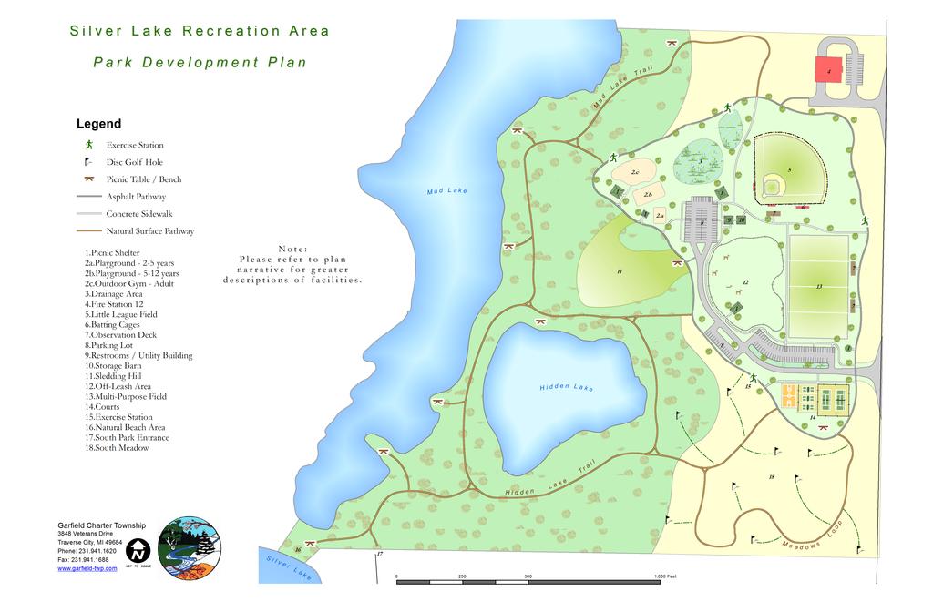
2 GARFIELD TOWNSHIP RECREATION PLAN 2012 AMENDMENT 1 INTRODUCTION The Charter Township of Garfield has developed this first amendment to the year parks and recreation master plan as a descriptive development plan for the Silver Lake Recreation Area at 1785 East Silver Lake Road and to amend the Township s land acquisition map in light of recent developments. The Silver Lake Recreation Area Development Plan is intended to establish milestones for desired improvements to the park as identified via the public involvement process when the 2012 park plan was created. The plan contains the following components: Development Plan Map Development Plan Map Descriptions General Policy Discussion o Tree Plantings / Invasive Species Removal o Park Lighting o Water Resources o Reservations The Amended Acquisition Plan is intended to replace pages 47 and 58 of the adopted Five-Year Parks and Recreation Master Plan. Amendments relative to these pages reflect a change in the protection status of the Verizon Wireless parcel (reference number A22) and a desire to acquire additional property to increase the recreational value of the Boardman Valley Nature Preserve by acquiring additional property suitable for a parking area and small park (A21, J. Dean Templeton Trust). P a g e 2
3 Page 3
4 This page intentionally left blank. P a g e 4
. 1.")
 indicated on the plan have been built.")
5 DEVELOPMENT PLAN DESCRIPTIONS The following describes existing and planned amenities at the Silver Lake Recreation Area. The majority of the improvements facilities described below were identified through the Public Involvement efforts of the Master Plan (see pages 33 and 34). 1. PICNIC SHELTERS Three of the five picnic shelters indicated on the plan are in existence. Two additional shelters are planned, one near the playgrounds and another near the multi-purpose field. 2. PLAYGROUND / OUTDOOR GYM AREA Two playgrounds (designed for 2-5 and 5-12 aged children) indicated on the plan have been built. Some comment received during the development of the Master Plan recommended that these playgrounds may be safer and more enjoyable if the wood mulch is replaced with rubber mulch. The third area in this vicinity is envisioned as an outdoor gym, or fitness zone. Outdoor gyms provide opportunity for adult health and wellness via a variety of exercise equipment built to withstand the rigor of weather. Because the equipment utilizes the user s body weight for resistance, it allows for both a safe and effective workout regardless of the age or fitness level of the users. In this location, the outdoor gym provides an opportunity for users to watch their children in the playgrounds while exercising. A high priority will be placed on establishing ADA-accessible fitness units alongside traditional units to ensure opportunity for all members of the community. As such, a wheelchair-friendly surface will also be required. A significant amount of shade tree plantings should occur in this area in the immediate future to provide for a cooler exercise environment. Comment also requested adding an additional picnic shelter and additional trash receptacles in this area. 3. DRAINAGE AREA & RAIN GARDEN The north drainage basin appears to have been grossly overbuilt for the amount of stormwater runoff that is generated by the north parking lot. Accordingly, it may be possible to decrease the size of this basin to reclaim some parkland for recreational use. The Township may consider establishing a rain garden within this basin to provide an example to the community of how modern stormwater systems can look and function. Alternately, it may be possible to establish a fishing pond within this basin. 4. FIRE STATION 12 Fire Station 12 was completed in The firehouse will continue to evolve into an important park neighbor by providing a sense of security to park users, and also from a recreational standpoint by offering firehouse walkthroughs for park goers. The planned network of pathways will provide ready access between the park and Station 12. Page 5

, additional bleachers, benches, and other seating should be installed as demand for field time increases. Grass hillside seating will also be an option due to topography. 6.")
6 5. LITTLE LEAGUE FIELD Historically used as a T-Ball field (an amenity lacking in the area), the field will be renovated to continue to serve T-Ball leagues but also act as a regulation-size Little League Field. To accommodate this, the playing surface must be shifted to the northeast while the existing backstop remains where it is today. An outfield fence must also be installed for the field. Quality dugouts will greatly increase the player experience while using this facility. In addition to an elevated viewing platform (see 7., below), additional bleachers, benches, and other seating should be installed as demand for field time increases. Grass hillside seating will also be an option due to topography. 6. BATTING CAGES Room exists to establish one or two batting cages along the right-field line of the ball field, providing an opportunity for simultaneous training and ball play. 7. OBSERVATION DECKS Taking advantage of existing topography, a number of elevated observation decks are planned adjacent to sports fields. These platforms will be level with the adjacent sidewalks or pathways and will provide an ADA-accessible opportunity to watch sporting events. 8. PARKING A new, eastern parking lot was built in 2012 adjacent to the multi-purpose field. Even though expanded, parking availability is anticipated to remain relatively tight as the park grows in popularity and demand for its resources increase. Past bad habits of vehicle parking on the grass alongside the driveways must be discouraged to avoid damage to the irrigation system; methods likely include a combination of signage, physical barriers, and enforcement by the Sheriff s Deputies who patrol the park. The Township should encourage frequent, common users such as sports teams to carpool to the park to conserve parking spaces. 9. RESTROOMS / UTILITY BUILDING No changes are planned to the existing restrooms, which are anticipated to adequately serve the park over the life of this plan. This structure also houses the electrical controls for the park and irrigation system. 10. STORAGE BARN An additional utility barn is proposed near the restrooms to provide storage space for sports equipment. This barn should be designed to enclose the well head, but must allow access to the well for future maintenance. Page 6


7 11. SLEDDING HILL Already a popular spot for sledding, the Township may consider formalizing this area into a dedicated sledding hill in the winter months. Careful consideration must be given to user safety if this sledding area is formalized, possibly including padded buffer walls to keep sledders within the designated hill area and away from trees. 12. OFF-LEASH AREA Desire for a dog park was one of the most popular comments received in the public input phases of the Master Plan. This fenced off-leash dog area will be a popular regional amenity, and is also anticipated to reduce the recurring problem of people walking their pet off-leash in other areas of the park (which is prohibited by ordinance). Planning and construction of this area should be a collaborative effort with local dog park enthusiasts, who can assist the Township in design and help develop a procedural policy for the park. This off-leash area is intended to be selfpolicing by the users. Consideration must also be given to providing a water source, perhaps most efficiently with a small well and hand pump. The woodland that this area encloses should be maintained, but appropriately thinned and managed. 13. MULTI-PURPOSE FIELD Constructed in 2012, this large area is designed to accommodate demand for all field sports such as rugby, football, lacrosse, and soccer. However, because it is also meant for the general public for casual uses such as kite flying or Frisbee tossing, the Township must take care to regulate league and club use to allow for adequate opportunity for public use. 14. COURT AREA BASKETBALL, PICKLEBALL, TENNIS Observations of park use have resulted in the planned reduction of one of the two existing basketball courts. In place of the basketball court, and also expanding towards the tennis court, three Pickleball courts will be installed. The existing two tennis courts will remain unchanged. 15. EXERCISE STATIONS In addition to the Outdoor Gym described above, a series of exercise stations are planned along the paved walking loop to provide an opportunity for well-balanced physical fitness. Typically, the participant will proceed from one exercise Page 7
8 station to the next and perform the exercise illustrated at each station. 16. NATURAL BEACH AREA The beach area provides a small but important opportunity for the public to access Silver Lake for swimming and recreation, which was one of the most requested improvements stated during the public input process of the 5-Year Master Plan. Presently, the remainder of shoreline is private property other than the DNR boat launch on East Silver Lake Road, where swimming is prohibited. The soils in the area may require a hard-surfaced walking path to maintain good access from the park. Because the beach area is located a significant walking distance from the parking lots, users are anticipated to come primarily from the neighborhoods to the south and/or users who may have completed a run or workout on the park s trail system and fitness equipment and are looking to cool off. Some families will likely walk from the parking area for picnic and swimming opportunities. Care must be given to keep this area open to park users without disturbing adjoining properties. As such, this area will remain in a primarily natural state, with only minor weed removal and cleanup contemplated. Additional signage should be installed here to indentify hours, property boundaries, and potential hazards such as unstable soils and the drop-off into the lake. 17. SOUTH PARK ENTRANCE The Lake Drive road right-of-way abuts the south property line of the park. This south entrance will be maintained in its current state to provide non-motorized access to the park from the adjacent subdivision. 18. SOUTH MEADOW Due to topography and sandy, unstable soils, the south meadow area will be maintained primarily for foot trails and open space. A small disc golf course may be possible within this area provided that it is appropriately designed to discourage players from walking off-trail and up and down the small hills. Page 8
9 GENERAL POLICY DISCUSSION DEVELOPED / NATURAL AREAS OF PARK In both current and planned states, most active recreation areas are concentrated within the eastern portion of the park (particularly those areas within the paved walking loop). Areas that lie west of the developed land should remain in a more natural state as a contrast to the developed land. The natural areas provide a useful buffer to the residential neighborhoods and give users the opportunity to enjoy a variety of recreational experiences. Trails within the natural area will be maintained in good condition, with attention given to poison ivy control. TREE PLANTINGS / INVASIVE SPECIES REMOVAL As time and budget permits priority should be placed to establishing a variety of vegetation for shade, aesthetics, and buffering. All plantings should be native to the region. To encourage deep root growth new trees should be located out of the path of regular irrigation system watering, or the irrigation system modified accordingly. Trees subjected to regular (bi-weekly) watering do not develop deep root systems. Prior to the planting of new trees effort must be made to eradicate the population of spotted knapweed near the restrooms. This invasive species emits a chemical that inhibits the health and growth of other plantings. Though the Silver Lake Recreation Area does not have a significant problem with other invasive species the park should be frequently monitored and problem species quickly removed. PARK LIGHTING Presently, the only lighting within the park is security lighting on the restroom facility. As the park is available for use from two hours before sunrise to two hours past sunset, additional lighting to illuminate the parking areas and paved walking loops is desirable. This lighting should be of a low-intensity and warm color so as not to disturb neighboring property owners. Intense lighting of the multi-purpose field or tennis courts is not appropriate. WATER RESOURCES The Silver Lake Recreation Area contains or has frontage on three separate water bodies; Silver Lake, Mud Lake, and Hidden Lake. As described above, continued use of a natural existing beach area has been identified for the park s Silver Lake frontage. A hard-surfaced pathway will be installed to improve access to this frontage. In current form, Hidden Lake is very shallow, perhaps 1-4 feet deep on average. Presumably the shallow depth comes from decades of aquatic vegetation growth, death, and infill. Page 9
10 Opportunity may exist to dredge this lake and establish a dedicated kids fishing pond. Prior to any dredging soil sampling would be necessary to determine if past agricultural use of the property has contaminated this pond. Mud Lake is also quite shallow, but offers opportunities for wildlife watching. A series of benches, observation decks, and picnic tables along the shores of this lake would be beneficial. The Township has heard reports that the sediment within Hidden Lake and Mud Lake can be hazardous to persons or animals entering the ponds. Therefore, postings should be installed to warn park users of the dangers of wading into the ponds. RESERVATIONS The following reservations recommendations either exist or should be implemented to ensure the most enjoyable experience for all park users. To allow for efficient policy changes from time to time these recommendations should be adopted by resolution of the Township Board rather than incorporated within this document. 1. RESERVATIONS LEAGUES a. Require reservations for regular league or club use and practice. b. Ensure adequate public opportunity to use facilities outside of regular reservation times (i.e. multi-purpose field). c. Require the designated league play area to be positioned to maximize open area for other users (i.e. a football field takes up significantly less than full multi-field area, and could be shifted to one area of the field). d. Ensure adequate parking exists so that vehicles do not park outside of designated parking areas. Require leagues to provide estimated traffic generation counts. If a league is anticipated to regularly generate traffic in an amount greater than 50% of available spaces, then that league is not likely an appropriate partner to the park. e. Permit leagues to use existing and future utility structures to store equipment. f. Adopt appropriate league fees which will contribute to maintenance costs 2. RESERVATIONS FACILITIES a. Establish time-slot reservation policy for picnic shelters rather than allowing all-day reservations for one fee. For example, start with 2-3 hours for $X, then charge hourly rates b. Identify one or two pavilions which may not be reserved to adequate opportunity for first-come, first-served use. Page 10
11 Page 11

12 G ARFIELD T O WNSHIP R ECREATION P LAN A MENDMENT 1 Page 58
13 This page intentionally left blank. Page 59
14 space development can protect and enhance the green infrastructure, while often creating useable nature areas for Township residents. When evaluating any application for land use development, the Township should analyze the existing natural characteristics of the development site, as well as the relation of those natural features to surrounding properties, to identify and encourage the preservation of these natural features. Table 4, below, identifies priority properties that have been identified for acquisition or protection though a conservation easement. The Green Infrastructure Plan map (see page 58) shows the location of each priority property, as well as other natural features such as streams and wetlands. As time permits, the Township should perform greater analysis of other green infrastructure elements such as significant woodlands. As noted above, though a particular property may not be indicated on the plan, efforts should be made to protect green infrastructure at all scales. Map Index Name Method of Protection A1 Silver Lake Connection to W. Silver Lake Road Acquisition A2 Commons State 40, Ransom Parcel Acquisition A3 Oleson PUD Open Space and Wetlands Donation A4 Oleson, Schmude Wetlands Acquisition A5 Applebees Parcel Aquisition, Access Emnt A6 Commerce Center Wetland Donation, Access Emnt A7 City-Owned Boardman Parcel Acquisition A8 Hanson Parcel Donation A9 Traverse Software Acquisition A10 Cass Road Self Storage Donation or Cons. Emnt, Access Emnt. A11 Miller Creek Corridor; BVNP / Miller Creek Connector Donation or Cons. Emnt, Access Emnt. A12 BVNP Parcels Acquisition A13 Logan Valley Pond Donation or Cons. Emnt A14 Misc. West Boardman River Parcels Acquisition A14-A Logan Valley Development Acquisition A15 Misc. East Boardman River Parcel Easements Easement A16 Fraser Parcel Acquisition A17 Future East Side Community Park? Acquisition A18 SVEC, McClain, Godziebiewski Parcels Acquisition A19 Airport Approach Donation A20 Boyd Acquisition A21 J. Dean Templeton Acquisition A22 Verizon Wireless Conservation Emnt / Acquisition CE1 Lewis, Church, Outlet Mall, Tireland Parcels Donation or Conservation Emnt CE2 Sleder Wetlands Donation or Conservation Esmt CE3 C D F, Chelsea Park Donation, Acquisition via PUD, Cons. Emnt P1 S. Airport Road Protected P2 Silver Lake Road Conservation Easement Protected P3 Lowes Wetlands Protected P4 Hughes Drive Protected P6 Misc. Ongoing Acquisitions Protected PUB 1 Future East Side Community Park? Publicly Owned (BPW) SP1 Silver Lake Elementary School School Park SP2 TC West High School School Park SP3 TC West Middle School School Park SP4 Former Sabin Elementary Playgrounds Donation SP6 Traverse Bay Christian School School Park Table 4 Green Infrastructure Program Page 47
1. Parks & Recreation Neighborhood Parks Community Parks Special Use Sites 2. Open Space 3. Trails
 Appendix A: Park Classifications The intent of parks and recreation classifications is to aid in making acquisition and design decisions for park sites, facilities and the organization of recreation space
City of Bonney Lake Allan Yorke Park. MASTER PLAN SUMMARY REPORT June 30, 2016
 City of Bonney Lake Allan Yorke Park MASTER PLAN SUMMARY REPORT June 30, 2016 TABLE OF CONTENTS INTRODUCTION PUBLIC INVOLVEMENT PROCESS MASTER PLAN North Park Central Park South Park East Park Field Development
Southeast Quadrant Plan
 Southeast Quadrant Plan Southeast Quadrant Distinctive Features Land Use The Southeast Quadrant includes all the area within the planning area that is east of Interstate 5 and south of State Route 44.
Long Branch-Wayne Local Park Renovation Project
 Montgomery Parks Long Branch-Wayne Local Park Renovation Project Community Meeting #2 September 20, 2016 Oak View Elementary School 7:00-9:00 PM Welcome / Team Introductions M-NCPPC (Montgomery Parks)
Charles P. Johnson and Associates. Annapolis Landscape Architects
 Charles P. Johnson and Associates Annapolis Landscape Architects AGENDA Introduction Project Limits and Scope Site Analysis Opportunities & Constraints Program Goals Image Boards Design Alternatives Pros
Project Location. Jay and Patty Baker Park and Gordon River Greenway Connector Bridge. Naples Beach Golf Club. Gordon River. East. Naples.
 Gordon River Project Location Naples Beach Golf Club East Naples Naples Naples Bay Evergreen Golf and Country Club and Gordon River Greenway Connector Bridge Gordon River Greenway CONNECTOR BRIDGE AND
Las Colonias Park Master Plan
 2013 Las Colonias Park Master Plan City of Grand Junction June 2013 Introduction Las Colonias Park, a 101 acre parcel on the edge of the Colorado River south of downtown, was deeded to the City of Grand
The Vision. Photo provided by The Minervini Group. 46 Vision, Objectives & Strategies
 Vision, Objectives & Strategies The is the public framework and guide for future development of the Grand Traverse Commons. The establishes public polices for infrastructure, the preservation of natural
Outdoor Recreation Facilities Inventory
 Outdoor Recreation Facilities Inventory Allouez Neighborhood Parks: East Lawn Park (4.90 acres) is located in the northeastern corner of Allouez near Boyd Street. This site contains: Baseball diamond with
MEMORIAL PARK MANAGEMENT PLAN
 MEMORIAL PARK MANAGEMENT PLAN Village of Elk Rapids, Michigan 2015 Developed by the Parks and Recreation Commission Planning Commission Approved, Village Council Approved, 1 Introduction The purpose of
Chapter 6. Overall Vision RECOMMENDATIONS. More Trail and Trail. Connections. Equal Access to Park. Facilities and Programs. Water Access.
 Overall Vision More Trail and Trail Connections Equal Access to Park Facilities and Programs Water Access Environment Variety Chapter 6 RECOMMENDATIONS Chapter 6 The following recommendations for park,
2. Analysis. DRAFT Gerald Richards & Pleasantview Park Master Plan
 DRAFT Gerald Richards & Pleasantview Park Master Plan 19 Historic Features According to the National Register of Historic Places and the National Historic Landmarks Program, there is nothing of national
PARTF Scoring System for Grants
 PARTF Scoring System for Grants The members of the N.C. Parks and Recreation Authority use the PARTF scoring system as one of several tools to select grant recipients. Please provide all of the information
Provide and maintain sufficient public parks, recreation facilities, and open space to meet the recreational needs of County residents and visitors.
 (ROS) Goal Provide and maintain sufficient public parks, recreation facilities, and open space to meet the recreational needs of County residents and visitors. OBJECTIVE ROS.01 The County shall acquire,
ANCHORAGE PARK REPORT CARD Assessing A Park s Appearance, Function, & Condition
 ANCHORAGE PARK REPORT CARD Assessing A Park s Appearance, Function, & Condition Park Name: Is Your Park an A or an F? Your Name: Contact Information Optional: Date: General Instructions: Phone: Email:
Northeast Quadrant Plan
 Northeast Quadrant Plan Northeast Quadrant Distinctive Features Land Use The Northeast Quadrant includes all the area within the planning area that is east of Interstate 5 and to the north of State Route
Rotary Park / Railroad Lake
 Rotary Park / Railroad Lake Park Location: 600 NW Vesper St. Park Land Established: 1975 Park Size: 12 acres Developed Acres: 12 acres Undeveloped Acres: 0 acres Park Type: Community Park Amenities: 2
Parks, and Recreation & Cultural Arts Master Plan Update
 Parks, and Recreation & Cultural Arts Master Plan Update Community Profile Public Input Summary: Staff Interviews conducted April 14 and 15, 2014 Citizens Workshop - conducted April 15 th and 24 th, May
Throughout. square. (Crystal City Vision Plan 2050)
") 1: Terms related to the PSMP document 1 public space (see also public realm, civic space) An open space designated on the regulating plan, accessible to all, including Plazas, Mini Parks, and Neighborhoods
1: Terms related to the PSMP document 1 public space (see also public realm, civic space) An open space designated on the regulating plan, accessible to all, including Plazas, Mini Parks, and Neighborhoods
Wilbur Young Park. Park Land Established: Developed Acres: 15 acres Undeveloped Acres: 25 acres
 Wilbur Young Park Park Location: 1100 SE Adams Dairy Parkway Park Land Established: 1987 Park Size: 40 acres Developed Acres: 15 acres Undeveloped Acres: 25 acres Park Type: Community Park Amenities: Shelter
Design Specifications & Requirements Manual
 11 PARKS & OPEN SPACES 11.1 DEFINITIONS... 1 11.1.1 Neighbourhood Parks... 1 11.1.2 District Parks... 1 11.1.3. Sport Parks... 1 11.1.4 Urban Parks... 1 11.1.5 Civic Spaces... 1 11.1.6 Open Space System...
Draft Master Plan for Franklin Park
 Draft Master Plan for Franklin Park Metro Parks Tacoma with SiteWorkshop November 2009 I. overview & background Process & History Master Plan Process The Master Plan is based on a community involvement
City Council March 27, Parks, Recreation, and Trails Master Plan
 City Council March 27, 2018 Parks, Recreation, and Trails Master Plan Planning Process Develop Goals and Objectives Inventory of Areas and Facilities Needs Assessment And Identification Public Participation
Y Sports Complex PROGRAMMING Capitol Improvement Plan. Anticipated/Suggested Improvements. Sedgwick County Park: Sports Complex:
 PROJECT OVERVIEW Location: East of Ridge Road, between 21 st Street and 13 th Street, not including SCZ In conjunction with The Sedgwick County Park Facilities Observation Report Compilation of improvements
Mendota Heights 2040 Comprehensive Plan Draft Vers
 4 Parks and Trails The City of Mendota Heights boasts a variety of recreational and open space opportunities. Few cities can claim access to regional trails, riverside and lakeside parks, scenic bluffs
Design Specifications & Requirements Manual
 11 PARKS & OPEN SPACES 11.1 DEFINITIONS... 1 11.1.1 Neighbourhood Parks... 1 11.1.2 District Parks... 1 11.1.3. Sport Parks... 1 11.1.4 Urban Parks... 1 11.1.5 Civic Spaces... 1 11.1.6 Open Space System...
APPENDIX C Township 9 Consistency with Applicable Plans
 Township 9 Consistency with Applicable Plans 1985 American River Parkway Plan Policies Project Consistency Policy 4.14: The following activities and facilities, which are incompatible with the Parkway,
Master Plan Workshop October 25, 2007 Charlotte Mecklenburg Government Center
 Master Plan Workshop October 25, 2007 Charlotte Mecklenburg Government Center Land Discussion 1. What are the most important land related issues we need to address? Protect natural areas Passive walking
Little Neck Planning Area
 Little Neck Planning Area Current Reality The Little Neck Planning Area is characterized by established residential neighborhoods, Town Center and Pembroke. The Eastern and Western Branches of the Lynnhaven
4.0 Concept Plan Implementation
 4.0 Concept Plan Implementation The following section defines the recommended strategy for the implementation of the Terwillegar Park Concept Plan including park management guidelines, capital costs, development
David Ache, representing Councilmember Hucker s office was present during the first portion of the meeting.
 Long Branch Wayne LP Renovation Project Community Meeting #1 March 8, 2016 Park Staff Present at Community Meeting #1 Lucas Bonney, Project Manager, Park Development Michael Ma, Park Development Tricia
UNIVERSITY OF MICHIGAN:
 Chapter Eight UNIVERSITY OF MICHIGAN: North Campus I. Introduction The University of Michigan currently owns approximately 800 acres of land in the northeast section of Ann Arbor. North Campus refers to
MASTER PLAN IMPLEMENTATION COSTS. Appendix A
 Appendix A MASTER PLAN IMPLEMENTATION COSTS Town of Bradford West Gwillimbury HENDERSON COMMUNITY PARK MASTER PLAN IMPLEMENTATION COSTS Draft Order of Magnitude Costing Revised 5/27/2014 ITEM DESCRIPTION
Benedict Fountain Park Meeting Notes Wednesday, February 15, 2012
 Benedict Fountain Park Meeting Notes Wednesday, February 15, 2012 ALTERNATIVE #1 Like the big open lawn space in alternative 1. Like cohesiveness of sidewalk walk and play areas shown on alternative 1
Special Revenue Funds
 Special Revenue Funds Special Revenue Funds account for the proceeds of specific revenue sources (other than special assessments for major capital projects) that are legally restricted to expenditures
Courthouse Planning Area
 Courthouse Planning Area Current Reality The Courthouse Planning Area is the characterized by expansive suburbanscale residential areas as well as the community resource planned area of athletic, educational,
Memo Preliminary. City of Miamisburg Parks Site Reconnaissance
 Memo Preliminary To: From: Ms. Rebecca Benna Woolpert, Inc. Date: Subject: City of Miamisburg Parks Site Reconnaissance The consultant team toured the existing Miamisburg Parks to assess current levels
City of Gainesville Parks, Recreation and Cultural Affairs Infrastructure Sales Tax City Commission Approved Project List
 City of Gainesville Parks, Recreation and Cultural Affairs Infrastructure Sales Tax City Commission Approved Project List Alfred A. Ring Park Description: Boardwalk replacement, signage and general park
Proposed Walkability Ordinance for City of Knoxville (6/16/17)
") Proposed Walkability Ordinance for City of Knoxville (6/16/17) New or revised text is highlighted Section 1: Purpose The purpose of this ordinance is to set requirements for walkability and pedestrian
Proposed Walkability Ordinance for City of Knoxville (6/16/17) New or revised text is highlighted Section 1: Purpose The purpose of this ordinance is to set requirements for walkability and pedestrian
The following principles guide the development of goals and strategies to protect and promote these amenities:
 OPEN SPACE/PARKS/TRAILS/RECREATION GOALS/STRATEGIES Cherry Hills Village is a living environment that offers low density development, open areas, public scenic vistas, public trails and public parks. This
The urban parks in Charlottesville include Jackson Park, Lee Park, and McGuffey Park.
 Park Classifications Charlottesville s parks can be grouped into 4 different classifications: urban parks, neighborhood parks, community parks, and regional parks. Figure 1 on page 5 inventories the facilities
A 2012 Clean and Safe Neighborhood Parks Bond Project. Katy Tang, District Supervisor. Jasmine Kaw, Landscape Architect Will Kwan, Architect
 West Sunset Park A 2012 Clean and Safe Neighborhood Parks Bond Project Community Meeting #2 November 20, 2013 Katy Tang, District Supervisor Dan Mauer, Project Manager Jasmine Kaw, Landscape Architect
Focus Groups. 8 Focus Group meetings including 2 with staff, 1 with seniors, and 1 with students
 Project Team Nan Lanahan, Parks & Recreation Jason Gallo, Parks & Recreation Rob Leslie, DEDP John Smolinsky, Planning Board Brent Meredith, Highway Joan Gavrilik, Friends of Parks & Rec MaryLyn Koval,
GOALS AND OBJECTIVES. This section includes Goals and Objectives for the communities of:
 GOALS AND OBJECTIVES The Goals and Objectives provide the overriding ideas and thoughts regarding the planning, development and maintenance of parks and recreation facilities and recreational opportunities
Section 3 INVENTORY OF RECREATION LAND AND FACILITIES
 Photo of Juan Bautista de Anza Park Section 3 INVENTORY OF RECREATION LAND AND FACILITIES Summary of Findings Park Definitions Summary of Recreation Facilities Other Recreation Facilities Nearby Recreation
A cknovvledgements. Table of Contents. Project Introduction...1
 Pashek Asscx::iates MARCH2007 A cknovvledgements Pashek Associates would like to thank Jackson Township and the Jackson Township Recreation Board for their valuable contributions, support, and input during
PARKS & RECREATION SUBCOMMITTEE. Oct. 1, 2015
 PARKS & RECREATION SUBCOMMITTEE Oct. 1, 2015 1999 Bond - $22,000,000 Land Acquisition Allen Station Phase II Neighborhood Parks PREVIOUS BOND ELECTIONS 1999 & 2007 2002 Bond - $4,000,000 Allen Senior Recreation
(Exhibit A) Site Plan Adoption Detail and Support Information
 Site Plan Adoption Detail and Support Information") McCormick Park Master Site Plan (Exhibit A) Site Plan Adoption Detail and Support Information July, 2003 McCormick Park Site Plans.... 2-3 McCormick Park Site Plan Comparison... 4 Basic Assumptions about
McCormick Park Master Site Plan (Exhibit A) Site Plan Adoption Detail and Support Information July, 2003 McCormick Park Site Plans.... 2-3 McCormick Park Site Plan Comparison... 4 Basic Assumptions about
Great Neck Planning Area
 Great Neck Planning Area Current Reality The Great Neck Planning area is characterized primarily by large lot/lowdensity residential development with the majority of recreational opportunity existing as
APPENDIX D: PARKS AND RECREATION ACTION PLAN
 APPENDIX D: PARKS AND RECREATION ACTION PLAN Goals The following goals are specific to the development, maintenance, and operation of the existing parks in the Township, as well as the acquisition and
nokomis-hiawatha regional park master plan and park improvements
 master plan and park improvements CAC Workshop # August 26th, 2014 charge of the cac The Nokomis Hiawatha Regional Park CAC shall: Become knowledgeable about the project and its scope Understand and represent
Draft Stillwater 2030 Comprehensive Plan- Goals and Policies
 Draft Stillwater 2030 Comprehensive Plan- Goals and Policies Instructions- Review each goal and policy and discuss with group any changes, deletions for additions to the list using your groups pen. Keep
SECTION II SECTION II STATEMENT OF GOALS, OBJECTIVES, PRINCIPLES, ASSUMPTIONS, POLICIES AND STANDARDS
 STATEMENT OF GOALS, OBJECTIVES, PRINCIPLES, ASSUMPTIONS, POLICIES AND STANDARDS 1 2 STATEMENT OF GOALS, OBJECTIVES, PRINCIPLES, ASSUMPTIONS, POLICIES AND STANDARDS INTRODUCTION The New Jersey Municipal
PARK DATA THEMES SUMMARY:
 area and identified key themes that should be addressed in the upcoming design process. The following is a compilation of the themes identified (organized by park). Not every park was addressed in this
North Oakville East Parks Facilities Distribution Plan. November, 2009
 North Oakville East November, 2009 POLICY CONTEXT 1) Purpose a) The purpose of this document is to be a guide for the location, configuration, design and development of the parks system for the North Oakville
Canal Winchester Parks Master Plan. Public Meeting 2 Thursday, February 2 6:30pm
 Canal Winchester Parks Master Plan Public Meeting 2 Thursday, February 2 6:30pm Meeting Agenda 1. Project overview 2. Project schedule 3. Public input results Survey Public Meeting #1 Stakeholder Interviews
Master Plan Presentation August 12, 2015
 Master Plan Presentation August 12, 2015 A vision for tomorrow... May, 13 2015 prepared for: prepared by: SITE LOCATION SITE NTS SITE ANALYSIS +/- 17.8 Ac. RESIDENTIAL HOMES 1 2 RAIL ROAD (SAFETY CONCERNS)
Pungo/Blackwater Planning Area
 Pungo/Blackwater Planning Area Current Reality The Pungo/Blackwater Planning Area represents the rural landscape and lifestyle that encompasses nearly 40% of Virginia Beach. The Agricultural Reserve Program
Parks, Recreation, and Open Space Land Use Goals
 Parks, Recreation, and Open Space Land Use Goals Issue: The preservation of open space and natural features will enhance the character of the built environment, promote public health and safety, provide
MADISON MANOR PARK RENOVATIONS
 MADISON MANOR PARK RENOVATIONS COMMUNITY KICK-OFF MEETING MINUTES To: Wilfredo Calderon, Steven Torgerson (AMT), Tom Mitchler, Kevin Stalica, Vincent Verweij, Greg Anselene, Chris Willett, Peter Alchin,
{Best Practices. Summary of Tools, Strategies and Best Practices from 11 Michigan Case Study Communities
 Case Studies Michigan Coastal Community Working Waterfronts { Summary of Tools, Strategies and from 11 Michigan Case Study Communities Table of Contents Zoning...2 Community and Stakeholder Collaboration
April 11, 2016 Park Board Chair and Commissioners General Manager Vancouver Board of Parks and Recreation New Brighton Salt Marsh - Preferred Concept
 TO: FROM: SUBJECT: April 11, 2016 Park Board Chair and Commissioners General Manager Vancouver Board of Parks and Recreation New Brighton Salt Marsh - Preferred Concept RECOMMENDATION A. THAT the Vancouver
SEWRPC OUTDOOR RECREATION AND OPEN SPACE PLANNING OBJECTIVES, PRINCIPLES, AND STANDARDS
 SEWRPC OUTDOOR RECREATION AND OPEN SPACE PLANNING OBJECTIVES, S, AND STANDARDS Introduction The Southeastern Wisconsin Regional Planning Commission (SEWRPC), as part of the regional park and open space
PARK PLANS OPERATIONS AND MAINTENANCE EAST OF THE RIVER PARK MASTER PL AN
 INTRODUCTION PLANNING PROCESS SERVICE AREA VISION PARK PLANS OPERATIONS AND MAINTENANCE IMPLEMENTATION 4 PARK PLANS EAST OF THE RIVER PARK MASTER PL AN 67 THIS PAGE WAS INTENTIONALLY LEFT BLANK NEIGHBORHOOD
Study Area Map. Wasatch Hollow Open Space Restoration, Use, & Management Plan. Legend. Harrison Ave East. Roosevelt East.
 Harrison Ave Roosevelt Emerson «4 «5 Rosecrest 1900 East «3 1800 East Wasatch Hollow Open Space Restoration, Use, & Management Plan Study Area Map Legend «2 «1 Potential Access Location Emigration Creek
RECREATION AND OPEN SPACE ELEMENT GOALS, OBJECTIVES, AND POLICIES
 RECREATION AND OPEN SPACE ELEMENT GOALS, OBJECTIVES, AND POLICIES Goal 7 To provide park facilities, recreation programs, and open space resources that are safe, adequate, and accessible to all City residents,
Park Types and Attributes
 02 APPENDIX B APPENDIX B s and s 194 APPENDIX B 04 Size Level of Service Any privately owned park, of any size, is a neighborhood park Primary Service Area - 1/2 mile or within 15 minutes walking distance
STAFF RECOMMENDATION: Adopt the Parks and Recreation Master Plan 2013, or take other action as deemed appropriate.
 Regular 7. CITY COUNCIL AGENDA Meeting Date: 12/02/2013 TITLE: Parks and Recreation Master Plan 2013 Adoption Proposal - Dwight Curtis Responsible Staff: Dwight Curtis Backup Material: Backup material
PART TWO: PROJECT SPECIFIC DESIGN GUIDELINES
 PART TWO: PROJECT SPECIFIC DESIGN GUIDELINES 2.1.0 GENERAL REQUIREMENTS: 1. Approved warm season turf varieties shall be used for LMD/CFD, commercial, industrial, and public landscape areas. The use of
Chapter 9 Community Facilities & Services Plan. Introduction. Cooperative Efforts. Monitoring of Needs
 Chapter 9 Community Facilities & Services Plan Introduction The location of key community facilities such as water, sewer, schools, parks, and roads is important to the provision of the necessary services
PARKS AND RECREATION ELEMENT
 PARKS AND RECREATION ELEMENT TABLE -3 First Priority 1 2 POTENTIAL SAN CARLOS TRAIL CONNECTIONS Crestview to Pulgas Ridge Open Space Preserve and San Francisco Watershed Lands Unimproved City-Owned Parcel
Appendix A Goals and Policies
 Appendix A Goals and Policies i This page left blank intentionally Introduction This Appendix lists the Goals and Policies from the adopted 1996 Parks and Recreation Master Plan. The Parks and Recreation
PLANNING APPROVAL & PLANNED UNIT DEVELOPMENT Date: November 2, 2017
 PLANNING APPROVAL & PLANNED UNIT DEVELOPMENT Date: November 2, 2017 DEVELOPMENT NAME LOCATION Mobile Christian School 5900 Cottage Hill Road (North side of Cottage Hill Road, 230 ± West of Freemont Drive
PARKS. Chapter Introduction
 Chapter 4. PARKS 4.1. Introduction This Parks Element of the 2016 Comprehensive Plan Update provides direction and guidance, based on citizen input, in order to improve and maintain the City s existing
MILLS PARK & PANTHER CREEK GREENWAY
 , North Carolina August 19th, 2014 Introduction, North Carolina Why are we here? Planning Investment to Date - Park, North Carolina 2012 Parks, Recreation, and Cultural Resources Master Plan Planning Investment
Appendix E Section 4(f) Evaluation
 Evaluation") Appendix E Section 4(f) Evaluation Appendix E Draft Section 4(f) Evaluation E.1 Introduction This appendix addresses a federal regulation known as Section 4(f), which protects parks, recreation areas,
Appendix E Section 4(f) Evaluation Appendix E Draft Section 4(f) Evaluation E.1 Introduction This appendix addresses a federal regulation known as Section 4(f), which protects parks, recreation areas,
November 21, Planning Commission Charter Township of Lyon Grand River Ave. New Hudson, MI 48165
 Planning Commission Charter Township of Lyon 58000 Grand River Ave. New Hudson, MI 48165 Subject: AP-18-68; 11 Mile and Milford Road Park, Site Plan Review #1 Based on site plan dated 11/12/18 Location:
WARM SPRINGS PARK MASTER PLAN
 TABLE OF CONTENTS page 1.0 Introduction and Overview 1 2.0 Information Gathering 2 3.0 Conceptual Alternative Development 8 4.0 Master Plan Development 14 5.0 Construction Cost Estimates 19 LIST OF FIGURES
& SUSTAINABILITY PLAN
 Chapter 6: IMPLEMENTATION, MANAGEMENT, & SUSTAINABILITY PLAN Overview The Oxbow Park and Zollman Zoo Master Plan presents a long-term vision for the park. While phasing of improvements is suggested, Olmsted
APPENDIX D2: PARKS AND TRAILS
 APPENDIX D2: PARKS AND TRAILS Cultivate Hopkins Comprehensive Plan 8/15/18 DRAFT Cultivate Hopkins Appendix D2 1 Existing Conditions Local Parks and Trails Figure D2.1 shows the existing park and trail
Municipal Development Plan. Summer Village of ROCHON SANDS. Bylaw #241-18
 Municipal Development Plan Summer Village of ROCHON SANDS Bylaw #241-18 TABLE OF CONTENTS PART ONE: BACKGROUND AND PURPOSE 3 SECTION 1: BACKGROUND 3 SECTION 2: GOALS AND POLICIES 3 PART TWO: PHYSICAL ENVIRONMENT
BAY DRIVE PARK Questions and Answers
 Q. How tall is the building near the beach and what will it look like? A. The Park Amenity Building is a two-story metal-roofed coquina-faced building with a restroom on the first floor and an observation
Tonight s Agenda. Disbrow Park & Facilities Master Plan
 Disbrow Park & Facilities Master Plan Public Outreach Forum City of Rye, NY May 11, 2017 Tonight s Agenda. Break (10 min) Introduction: What s in the works? Stantec Presentation - Goals and objectives
3.0 Community Consultation. BW Land
 3.0 Community Consultation A BW Land 3.0 Community Consultation See Appendix G The Results of the Public Consultation 3.1 Community Consultation The community consultation consisted of three open house
I-494 Rehabilitation Project SP (I-394 to Fish Lake Interchange) June 2014 Section 4(f) De Minimis Determination
 June 2014 Section 4(f) De Minimis Determination") I-494 Rehabilitation Project SP 2785-330 (I-394 to Fish Lake Interchange) June 2014 Section 4(f) De Minimis Determination State Project Number 2785-330 Federal Project No. NHPP-I494 (002) Trunk Highway:
I-494 Rehabilitation Project SP 2785-330 (I-394 to Fish Lake Interchange) June 2014 Section 4(f) De Minimis Determination State Project Number 2785-330 Federal Project No. NHPP-I494 (002) Trunk Highway:
Recreation Facility Evaluation - Conclusions
 2015 Parks Report Upon initial assessment of the Village parks it was evident that the inventory of the Village s park land, athletic fields, recreational facilities, playgrounds, trails, etc., was substantial,
3.2 P - Park District
 3.2 P - Intent - The P: s are established to promote and maintain the development of recreational opportunities within the. The development of new parks or the major expansion of existing parks within
Planning Board Briefing
 Planning Board Briefing Why Now? The Sector Plan Implementation Chapter States: Before Stage 1 begins, the following must occur: Approval of the Sectional Map Amendment. Approval of the Greater Lyttonsville
10.0 Open Space and Public Realm
 10.0 Open Space and Public Realm 10.0 Open Space and Public Realm The Public Open Space System is comprised of: outdoor spaces available for public use that are either publicly owned (e.g., parks and
VISION PLAN PRESENTATION - SEPTEMBER 28, 2013
 AREAS OF IMPROVEMENT E A POOL HOUSE POOL DECK B B MAIN BUILDING UPPER PLAZAS A D F G C MAJOR BLEACHERS DUGOUTS FIELD MAIN COURTYARD D REGGIE PARK C E SPORT COURT ADA RAMP H F G H TENNIS COURTS KITCHENETTE
PUD GUIDE FOR THE RED MOUNTAIN RANCH PLANNED UNIT DEVELOPMENT
 PUD GUIDE FOR THE RED MOUNTAIN RANCH PLANNED UNIT DEVELOPMENT Exhibit B to the Annexation and Development Agreement October 15, 2018 *Notes in red are intended for Town of Eagle review purposes and are
Bullhead City Rotary Park Plan Update
 Bullhead City Rotary Park Plan Update PLANNERS/LANDSCAPE ARCHITECTS: RBF Consulting 16605 N 28 th Avenue Suite 100 Phoenix, Arizona 85053-7550 (602) 467-2200 CIVIL ENGINEER: RBF Consulting 16605 N. 28
CHAPTER 22 Rural Open Space Community Developments
 CHAPTER 22 Rural Open Space Community Developments Section 22.1 Description and Purpose The intent of this Chapter is to offer property owners an alternative to traditional zoning requirements for rural
Parks and Recreation Master Plan City of Willmar, Minnesota
 Parks and Recreation Master Plan City of Willmar, Minnesota Draft February 2015 Parks and Recreation Master Plan City of Willmar, Minnesota February 2015 Draft Prepared for: Willmar Community Education
29 Bella Fontaine Park
 29 Bella Fontaine Park 9565 Bellefontaine Road St. Louis County Parks Master Plan Planning Zone 2 Visit Date: July 2016 Page 1 129 Bella Fontaine Park 9565 Bellefontaine Road St. Louis County Parks Master
GENERAL INFORMATIONaaaaaaaaaaaaaaaaaaaaaaaaaaaaaaaa
 To: Planning and Zoning Commission From: City Staff Date: November 15, 2016 Re: Case #16026 Raymore Activity Center Site Plan GENERAL INFORMATIONaaaaaaaaaaaaaaaaaaaaaaaaaaaaaaaa Applicant/ Property Owner:
Lasley Park Design Concepts Feedback from meeting on March 3, 2016
 Lasley Park Design Concepts Feedback from meeting on March 3, 2016 1. Which design concept do you prefer for the play experience? 2 1 4 1 2 3 C and E - I like the boulders C and E Lots of different play
9 th Street Sub Area Plan
 9 th Street Sub Area Plan In the 1990 s, when the Township prepared the last Master Plan, the 9 th Street corridor was studied as part of a larger 9 th Street Focus Area that included the West Main Street
ACADEMY AREA CONCEPT PLAN
 ACADEMY AREA Strip ling C hape l Roa d CONCEPT PLAN 7 S2 U Stripling 52 ROADWAYS AND PARKING: ADVENTURE PLAYGROUND AND SPRAYGROUND: Current roadways follow existing drives. It is recommended that the Folds
Montana Rail Link Park
 Montana Rail Link Park Neighborhood Open House A Missoula Community Partnership WITH LEADERSHIP FROM THE FRANKLIN TO THE FORT & SOUTHGATE TRIANGLE NEIGHBORHOODS Sovereign Hope Church, (1919 North Ave.)