Prepared for Metrolinx by:
|
|
|
- Silvia Sparks
- 6 years ago
- Views:
Transcription


1 Mount Dennis Mobility Hub Study August 2013

2 Prepared for Metrolinx by:
3 Acknowledgements Community Liaison Group Patrick Saavedra Barbara Stone Marabelle McTavish Barbara Spyropoulos Robyn Hoogendam Robert Caplan Ross Bonomo Lise Dube Wady Dyson Father Schuyler Brown Fidenzio Salvatori Mike Sullivan Frank DiGiorgio Laura Albanese Frances Nunziata Elected Officials Councillor Frances Nunziata Councillor Frank Di Giorgio MPP Laura Albanese MP Mike Sullivan Technical Advisory Committee Metrolinx James Hartley Adriana Trujillo Randal Dreise David Veights Franca DiGiovanni Sampson Ho Frank Altomare Metrolinx RTI Consultants Chris Haylock Grant Wood Andrew Harper Jim Berry City of Toronto Richard Beck Lou Moretto Greg Byrne Edna Cuvin Jack Krubnik Hans Riekko Garvin Tom TRCA Beth Williston Caroline Mugo TTC Bill Dawson Metrolinx Mobility Hub Project Team Ian Griffiths Lisa Salsberg Daniel Haufschild Leslie Woo Joshua Engel-Yan Marcus Bowman Consulting Firms Urban Strategies Inc. McCormic Rankin Corporation Cushman & Wakefield Swerhun Facilitation and Decision Support
4
5 Table of Contents Summary 4 Enhancing Access 87 1 Introduction Enhancing Access for Pedestrians and Cyclists 4.2 Supporting Access by Vehicles Overview 1.2 The Mobility Hub Study process Implementation and Partnerships 93 2 Background 2.1 Planned Transit Improvements 2.2 The Mount Dennis Community 2.3 The Opportunity The Changing Market Over Time 5.2 Key Partners for Implementation 5.3 Next Steps 6 Summary of Key Directions Key Directions 3.1 Five Focus Areas 3.2 The Kodak Lands 3.3 Eglinton Avenue 3.4 Weston Road 3.5 Black Creek Triangle 3.6 Black Creek Business Park 3.7 The Opening Day and Long Term Vision Built Form and Land Use 6.2 Mobility 6.3 Public Realm 6.4 EPR Addendum Issues

6 Summary The Mount Dennis Mobility Hub Study establishes a long-term vision for the Mount Dennis Station and surrounding lands of a higher-density, mixed use environment connected by an expanded pedestrian and cycling network. Key elements of the long-term vision include: 1. A multi-modal station that provides seamless connections between light rail, heavy rail, and bus transit, centered around the re-purposed historic Kodak Building; 2. The transformation of Eglinton into a greenway connecting the two valleys and extending the Humber trail network east to the new community centre and beyond; 3. The revitalization of Weston Road as the principal community and retail spine, centred upon a new station and green plaza space and supported by new development; 4. New mixed-use development on the Black Creek Triangle site which relates positively to Keelesdale Park and the Station and preserves for a new GO entrance and connection between Weston Road and the community centre; 5. An economically vibrant and pedestrian-friendly Black Creek Business Area that benefits from the new Maintenace and Storage Facility (MSF), with more amenities, more economic activity, and an enhanced image; and 6. High quality streets, public spaces and transit facilities throughout the mobility hub. Fergy Brown Park Multi Use Path Eglinton Flats The Long Term Vision


7 BCBA Open Space Black Creek Business Area Valley Restoration and Storm Water Management MSF Mount Dennis Park Primary Station Entrance Kiss n Ride Kodak #9 (Community / Office Uses) Office Development Pedestrian Promenade and Multi-Use Trail New GO Connection Coronation Park Mixed Use Development York Community Centre Keelesdale Park Eglinton Avenue Retail Main Street Black Creek Drive Weston Road Neighbourhood Street Connections Weston Road and Black Creek Drive

8 Achieving the long-term vision won t happen over night, but over the long-term, following the introduction of light rail transit (LRT) and the gradual improvement in real estate market. The following report presents a series of strategies and actions for Metrolinx, the City, community members and other organizations to help achieve the Mount Dennis Mobility Hub vision over time. Stage 1: Opening Day The completion of the Eglinton Crosstown LRT (the Crosstown) in 2020 will result in a number of improvements to the Mount Dennis Station Area. In addition to improved accessibility, the Eglinton Corridor will be enhanced with new streetscaping, a multi-use path extension and wider sidewalks along the north side of the street. Stage 1: Opening Day Stage 2: Residential Market and Main Street Improvements In the shorter term people will be attracted to the area by good transit access and lower housing costs in comparison to other parts of the city. This change will be reflected in improvements to the existing housing stock and may result in some smaller 2-3 storey infill housing and townhouse developments. The increase in housing demand, coupled with new residents interested in urban living but priced out of other neighbourhoods is expected to result in an improvement to the retail market along Weston Road. This may lead to a re-occupation of vacant storefronts as residents look for new amenities and services. Stage 2: Residential Market and Main Street Improvements


9 Stage 3: New Residential Development As residential demand increases and new uses begin to open up along Weston Road the residential market may improve to a point where it becomes viable for higher density forms of development. This would most likely occur first within the Black Creek Triangle area south of Eglinton Avenue and/or at the entrance to the station off of Weston Road where there is good visibility and access. Stage 3: New Residential Development Stage 4: Higher Density Residential Development and Office As the residential market continues to improve over time, it will be possible to attract even higher density forms of development. This will help to increase activity levels and will be important to encouraging new retail uses in and around the station area. It is only once the area has developed an attractive urban environment with diverse housing choices, new retail, restaurant and entertainment uses that the area may see interest from office tenants. If the Crosstown line is extended further west and the bus terminal is no longer needed, the site has been designed to allow the extension of Photography Drive north and the creation of a new development parcel on the bus terminal site which would be suitable for more intense development. Stage 4: Higher Density Residential Development and Office

10 10 Mount Dennis Mobility Hub Study

11 Introduction 1 Chapter 1 Introduction 1
.")


 line; The location of a future GO Train Station along the GO Kitchener commuter rail line; and The")
12 1.1 Mount Dennis has been identified as one of 51 Mobility Hubs in The Big Move: the Transit Plan for the Greater Toronto and Hamilton Area (GTHA). Mobility Hubs are significant transit stations because of the level of transit service planned for them and the development potential around them. They are intended to be connected places, where different modes of movement are seamlessly connected and there are opportunities to integrate concentrations of living, working, or playing. Mount Dennis is planned to be: Overview The terminus station of phase 1 of the Eglinton Crosstown Light Rail Transit (LRT) line; The location of a future GO Train Station along the GO Kitchener commuter rail line; and The location of a 15 bay Toronto Transit Commission (TTC) bus terminal. The 51 Mobility Hubs identified within the Big Move 2 Mount Dennis Mobility Hub Study The 51 Mobility Hubs identified within the Big Move

13 The Eglinton Crosstown LRT The Eglinton Crosstown LRT (the Crosstown) will run along Eglinton Avenue through the geographic centre of the city, resulting in a 60% increase in transit travel speeds across the corridor. The first phase, which is planned to be built by 2020 will connect Mount Dennis Station in the west with Kennedy in the east. The Mount Dennis station in relationship to key transit corridors Chapter 1 Introduction 3
14 The Mobility Hub Study The Mount Dennis Mobility Hub Study focuses on the lands within an 800m radius of the new station. The study presents options for how the new station can best serve the Mount Dennis community and provide seamless, easy connections between LRT, regional rail, local bus services and the surrounding area. The document is intended to be used by a variety of stakeholders including Metrolinx, the City of Toronto, community groups and other organizations to help them to coordinate their activities to create a more transitsupportive station area. On lands owned by Metrolinx, the study will establish a long-term vision for surrounding areas and provide specific recommendations for how the design of the station can help to support broader objectives for the study area. For lands outside of Metrolinx ownership, the study will provide guidance to the City of Toronto so that the City can: Consider updating their zoning and land use policy framework prior to completion of the station; and Respond to development proposals with concrete recommendations that support a wider vision for the station area. By proposing specific public realm improvements, including better pedestrian and cycling connections, the Mobility Hub Study will help to prioritize investments in new or improved infrastructure to be undertaken by the City, Metrolinx or in partnership with other agencies/ organizations. The six key objectives for the Mobility Hub Study are to: Assist in the development of a fully integrated transit station that facilitates transfers between rail and bus services, and the surrounding area; Identify opportunities to re-purpose the Kodak building by integrating the building within the station and designing the station to support access to the building by other users; Identify opportunities and priorities for public realm and streetscaping improvements; Identify opportunities to enhance pedestrian/cyclist connectivity; Explore the potential for transit oriented development on lands adjacent to the Metrolinx property; and Assist in the development of the phasing and implementation of mobility hub components. 4 Mount Dennis Mobility Hub Study


15 Metrolinx Owned Lands 800m Coronation Park Bartonville Avenue Black Creek Drive Weston Road Fergy Brown Park Eglinton Avenue Photography Drive Keelesdale Park Jane Street Guestville Avenue Eglinton Flats Lambton Avenue Metrolinx owned lands in relationship to the study area Chapter 1 Introduction 5


16 1.2 The Mobility Hub Study Process Metrolinx began the Mount Dennis Mobility Hub Study in June of Two committees participated in the production of the Study: a Technical Advisory Committee, which consisted of representatives of the TTC, the Metrolinx Station Design Team and Environmental Assessment Team and GO Transit Staff; and a Community Advisory Committee, made up of members of the Mount Dennis community and key stakeholders. Key Stages in The Process As part of the Mobility Hub Study, Metrolinx hosted public engagement activities at four different points in the process. The first Public Open House was held in the summer of 2012 to introduce the study process and the planned transit improvements. A second Public Open House was held on December 12, It focused on the current conditions in the study area and presented the consultant team s preliminary analysis of the opportunities for improvement in the area surrounding the station. Attendees provided suggestions and offered a number of priorities for public realm improvements and station design. A week after the second Public Open House, Metrolinx, in collaboration with the City of Toronto, hosted an Economic Development workshop. This focused on leveraging transit investment to provide local job opportunities. The workshop was well-attended and marked the beginning of an ongoing working relationship between Metrolinx and the City of Toronto focused on local job training and provision. The third Public Open House was held on April 10, The Open House provided an opportunity for the public to see the final recommendations for development and public realm improvements in the lands around the station. Comments arising from this Open House have informed the final Mobility Hub Study document. Complimentary Initiatives The Mount Dennis Mobility Hub Study was completed in coordination with a number of other initiatives currently underway in Mount Dennis, including: improvements to the GO Transit Kitchener Rail Corridor (Metrolinx), providing infrastructure required to support expanded GO Transit service and the Union-Pearson Express; an addendum to the Environmental Project Report (EPR) for the Eglinton Crosstown LRT (Metrolinx); and Eglinton Connects (City of Toronto), a planning study undertaken in partnership with Metrolinx to develop an urban design and public realm vision for the Eglinton corridor. 6 Mount Dennis Mobility Hub Study

17 Key Stages in the process and complimentary initiatives Chapter 1 Introduction 7

18 8 Mount Dennis Mobility Hub Study

19 Background 2 Chapter 2 Background 9
20 2.1 Planned Transit Improvements As a Phase 1 terminus station on the Crosstown LRT, Mount Dennis station is being designed to support access to a wide range of transit services. The surrounding area will also be the home to a Maintenance and Storage Facility (MSF) which will serve the vehicles for the Crosstown. The diagram on page 11 illustrates the major new planned infrastructure that will be introduced to the Mount Dennis area as part of the construction of the Crosstown. Mount Dennis Station will have two main entrances. The primary entrance (1) will be on the northeast corner of Weston Road and Eglinton Avenue and will open onto a new park space created at the intersection. The secondary station entrance (2) will be on the north side of Eglinton Avenue, just east of the existing rail overpass. The new station will connect to a 15 bay bus terminal (3) and a Passenger Pick-up and Drop-off (PPUDO) area (4) located immediately north of Eglinton Avenue. Passengers will connect to the station along a dedicated pedestrian concourse through Kodak building No. 9, which will be preserved and incorporated into the station design as an important point of transfer between the various transit services. Mount Dennis station will also connect to a new GO Transit stop (5). The GO Transit Kitchener Rail corridor intersects with the Crosstown at Mount Dennis and the station is being designed to provide a direct connection to a new GO platform. GO Transit anticipates that the new platforms will open with Mount Dennis Station in The platforms are being designed to accommodate UP Express trains in the future. An important component of Mount Dennis Station is the Maintenance and Storage Facility (MSF), which will service the light rail vehicles using the Crosstown. The MSF (6) will be located on land formerly owned by the Kodak Company, directly north of Eglinton between Black Creek Drive and the CN Rail Corridor. Metrolinx purchased the Kodak site because its size could accommodate the servicing and cleaning of trains and the provision of track maintenance facilities. The MSF is being designed to store approximately 160 cars (54 trains), to allow for the future expansion of the Crosstown service over time. 10 Mount Dennis Mobility Hub Study
 Passenger")
")

21 (6) Maintenance and Storage Facility Coronation Park (5) GO Transit Platforms Weston Road LRT Station (4) Passenger Pick-up and Drop-off (3) Bus Terminal Eglinton Avenue Kodak Building No 9 Black Creek Drive York Community Centre (1) Primary Station Entrance (2) Secondary Station Entrance The planned transit facilities Photography Drive Chapter 2 Background 11
22 2.2 The Mount Dennis Community The Mount Dennis neighbourhood is a diverse community experiencing a number of challenges including lower than average household incomes and education attainment rates, a struggling main street and poor real estate market. Despite these challenges, the area benefits from active and engaged residents, elected officials who are working to secure neighbourhood investment and a unique natural setting located between two valley systems. The People Mount Dennis is a culturally diverse community with a high percentage of first-generation Canadians. Although there is sustained commitment to improving the number and quality of jobs in the area, the average household income remains lower than the rest of Toronto and the area has been designated a Priority Neighbourhood for social and capital investment. Rents and property values in Mount Dennis remain lower than the rest of the city, however the neighbourhood provides a good mix of housing options, from single-family detached homes to high-rise residential buildings. 28% of residents in Mount Dennis use public transit, which is provided by buses along Weston Road and Eglinton Avenue. The Built Environment Centred along Weston Road, Mount Dennis is bound to the east and west by park lands associated with the Humber River and Black Creek valley systems. These contain a mix of active and passive recreational uses in a wooded setting. In addition to these open space amenities, a new York Community Centre is being built at Black Creek Drive and Eglinton Avenue. Weston Road is predominantly low-rise in scale. The street has had a predominantly retail focus, although in recent years there has been an increase in conversion to residential uses, particularly new townhomes. Running to the east and parallel to Weston Road is the GO/CPR rail corridor, which forms the eastern boundary to Mount Dennis s residential neighbourhoods. The neighbourhood is comprised predominantly of single detached housing interspersed with small walkup apartments. Several high-rise residential buildings are located adjacent to the rail corridor and just east of Eglinton Flats. Eglinton Avenue is an important east-west connection through the Mount Dennis community. While much of the street to the east of the neighbourhood can be characterized as main street, west of Keele, Eglinton Avenue is characterized predominantly as a wide avenue with larger setbacks, no retail and a more natural setting. The two largest areas of undeveloped land in Mount Dennis are located between the rail corridor and Black Creek Drive on either side of Eglinton Avenue. To the north are the Kodak Lands, a former industrial site. These lands are owned by Metrolinx and will be used for LRT infrastructure including the MSF and station. To the south is the Black Creek Triangle. It is currently the site of a large No Frills grocery store and a proposed gasoline bar. It also contains a small piece of City-owned land at the western corner of the site. The Black Creek Business Area, north of the Kodak Lands, is comprised of a mix of warehouse, office uses and light manufacturing and retail uses. Although the area has shifted from a predominantly manufacturing focus towards more warehousing, it remains a successful local employment area. 12 Mount Dennis Mobility Hub Study

23 The Real Estate Market Conditions A component of the Mobility Hub study process was to examine the current real estate market conditions to assess how these might change with the introduction of new public transit to the area and assess the likelihood of attracting new development. Mount Dennis property values and rents per square foot are comparatively lower than the rest of the city. This makes it difficult to attract new investment as developers are more likely to focus efforts in areas with higher rates of return. Residential Currently, houses in Mount Dennis have an average resale price of $284,000 at an average of $220 per square foot (psf). It is estimated that it may be possible to achieve a condominium sale price of $270 psf for a new building in Mount Dennis, compared to an average of $554 psf in the City of Toronto and $491 psf in North York. Given these prices, the most realistic form of development over the short- to medium-term (0-15 years) is wood-frame 2 to 4 storey townhouse or stacked townhouse development. It is estimated that a resale price of $425 psf would be required to support mid-rise construction of between 5 and 8 storeys. While it is expected that the new station will help to enhance the market, achieving an increase of this magnitude is expected to occur over the longer term (15-25 years). Office There is currently no office market in Mount Dennis. A comparative analysis against similar locations in the city suggests that it might be likely to attract rents of between $13 and $14 psf following the completion of the LRT. This is approximately half of what would be required to turn a profit. The viability of office over the long term (15-25 years) will depend on the ability to create an attractive urban environment offering diverse housing choices or retail, restaurant, entertainment and fitness amenities that will support employee recruitment and retention. Retail In comparison with other areas of the city, a higher percentage of people are traveling outside the area to meet their retail needs. A large number of Mount Dennis residents shop at the Crossroads Mall (at Weston Road & 401) and at the big box retail centers located at Weston Road and St. Clair Avenue. Although the options presented by these large-format retail centres are appealing, Mount Dennis residents have expressed a desire to see more retail along Weston Road. Eglinton Flats Ray Avenue Weston Road Black Creek Business Area Industrial The relatively low heights of many of the buildings in the Black Creek Business Area means that the area is no longer attractive to new industrial users. Because of this, the area is slowly shifting toward a focus on storage and light manufacturing. This area may also be viable as a retail employment area, offering discount pricing within a warehouse environment however, this would need to be consistent with existing policy and may need to be considered as a component of a comprehensive policy review. Former Kodak Lands Eglinton Avenue Black Creek Drive Black Creek Triangle Coronation Park Keelesdale Park Aerial of the Mount Dennis community Chapter 2 Background 13


24 A view of Eglinton Avenue looking east from Photography Drive illustrating the more natural characteristic of the street west of Keele 6 lanes of traffic and dedicated turning lanes create an unfriendly crossing at Black Creek Drive and Eglinton Avenue 12 The Black Creek Triangle between Black Creek Drive and Eglinton is a large site with potential for redevelopment over time The large retaining wall and narrow sidewalks along the north side of Eglinton Avenue creates an inhospitable environment for pedestrians Narrow sidewalks beneath the rail corridor and Photography Drive add to the inhospitableness of Eglinton Avenue 14 Mount Dennis Mobility Hub Study


25 Weston Road is comprised predominantly of low-rise mixed use main street buildings In recent years investment in streetscaping has helped to enhance the image of the street In recent years a poor market has resulted in the conversion of older retail uses to townhouse development along Weston Road The Mount Dennis neighbourhood is comprised primarily of single family detached dwellings Several high-rise residential buildings are located adjacent to the rail corridor and just 3 east of Eglinton Flats Older warehouse spaces in the Black Creek Business Park are not conducive for re-use as new warehouse or office spaces Chapter 2 Background 15
26 2.3 Transit The Opportunity Despite the challenges facing the neighbourhood, the completion of the Crosstown and the development of Mount Dennis Station has the potential to catalyze change within the community. investment alone may not have a significant impact on Mount Dennis, but when combined with sustained investment in the community, it can help strengthen existing neighbourhoods, provide a new mix of people and uses in the community and support local jobs. Strengthening Existing Neighbourhoods When complete, the Crosstown will enable residents of Mount Dennis to get to the Yonge Street subway in just 18 minutes. The relatively low housing prices in Mount Dennis, when combined with investments in new community facilities and improved transit access will create conditions that can lead to an increase in demand for existing neighbourhood housing. As the value of existing houses rises, the residential market will eventually improve the viability and quality of retail on Weston Road. Over the longer term, with continued investment in the areas streets and open spaces, new forms of higher density housing may be viable. This will help to increase the diversity of the existing neighbourhood, providing a greater mix of housing types and transforming underutilized sites into more active, inviting places over time. Supporting Jobs While the Maintenance and Storage Facility may provide a number of local jobs, the real gain for the Mount Dennis community in the short term will come from the reduced commute times and expanded access to employment opportunities throughout the rest of the city. This is particularly important in Mount Dennis given the notable percentage of residents who rely on transit. In addition to providing enhanced transit service, Metrolinx has committed to working with the City of Toronto Economic Development division to discuss economic development initiatives such as opportunities for employment training and job creation during the construction of the Crosstown. In the longer term, employment opportunities will come from the strengthening of the real estate market and increased ability for small business creation along the Weston Road main street. While the existing building stock in the Black Creek Business Area may no longer be appropriate for large industrial uses, the increased profile resulting from the LRT and the return of a workforce to the Kodak Lands will help to strengthen the Black Creek Business Area by supporting its transition to a light warehousing destination with ancillary retail, small scale employment uses and supporting services 16 Mount Dennis Mobility Hub Study
27 Attracting New People and Uses The increased profile and enhanced accessibility provided by the Crosstown line will help to attract new people and uses to the Mount Dennis Community. This will lead to more activity on the streets which will in turn increase the safety of the surrounding neighbourhoods. An increase in the number of people in Mount Dennis will have a positive effect on local shops as new people, with different backgrounds begin demanding a broader variety of retail. In the short-term, opportunities for new retail and uses will be most evident at or around the station. Over the longer term opportunities will occur as softer sites throughout the neighbourhood are redeveloped. Visitors will be able to take the Crosstown to Mount Dennis, whose proximity to the Black Creek and Humber River valley systems and new civic destinations, such as the new York Community Centre, will attract people who may never have thought to visit the community before. Enhancing the Setting Mount Dennis benefits from outstanding parks and natural areas. The new station will directly improve the connections between these areas while setting the stage for future enhancement of green spaces throughout the neighbourhood. Two of the significant park systems in Mount Dennis, the Humber River and Black Creek, have been separated for years by the CN rail corridor. As part of station development, Eglinton Avenue, which connects these two parks, will be improved with widened sidewalks on the north side of the street and new street trees. This will help to enhance the park-like setting along Eglinton Avenue and link the two valleys while creating a safer, more pleasant pedestrian environment. In addition to enhancements along Eglinton Avenue, an opportunity will exist at the site of the station entrance at Weston Road to create a new station related open space. Together these improvements will help to enhance the setting and image of the neighbourhood and compliment other initiatives along Weston Road, in the valleys and throughout the neighbourhood. Chapter 2 Background 17

28 18 Mount Dennis Mobility Hub Study

29 Key Directions 3 Chapter 3 Key Directions 19


30 3.1 The Five Focus Areas The Mount Dennis neighbourhood is a diverse area with a range of settings, each of which have unique challenges and opportunities. In order to respond to these distinct environments, the Mobility Hub Study divided the station area into 5 key areas of focus. The following section provides an overview of the 5 focus areas outlining the current condition and future opportunities. These are followed by a series of area-specific strategies aimed at achieving the vision for each area and supporting transit ridership over the long-term. Each strategy is supported by a range of graphic imagery and precedent pictures. These are illustrative for the purpose of providing meaning and a possible visual interpretation of an outcome that the strategy and the actions hope to achieve. 1. The Kodak Lands 2. Eglinton Avenue 3. Weston Road 4. The Black Creek Triangle 5. The Black Creek Business Area Mount Dennis Mobility Hub Study

31 The five focus areas of the Mount Dennis Mobility Hub study INDUSTRY STREET TODD BAYLIS BLVD 5 BLACK CREEK DR TRETHEWAY RD RAY AVE 1 CORONATION PARK JANE ST FERGY BROWN PARK 3 ASTORIA AVE * * EGLINTON AVE W 4 PHOTOGRAPHY DR WESTON RD BLACK CREEK DR KEELESDALE PARK 2 EGLINTON FLATS Chapter 3 Key Directions 21

32 Industry Street 3.1 The Kodak Lands Ray Avenue Coronation Park The Kodak Lands Today The Kodak Lands are a large parcel of land east of the rail corridor between Eglinton Avenue, Industry Street and Black Creek Drive. It is the former site of a large Kodak plant which occupied the area from 1913 to The site has since been cleared and all that remains is Kodak Building No.9, the former employee building for the plant. Kodak Building No.9 sits on an elevated piece of land overlooking the city and will be preserved by Metrolinx. While the site is substantial in scale, it is currently isolated from the residential and retail community by the rail corridor to its west and a significant grade change to the south along Eglinton Avenue. The eastern side of the site, alongside Black Creek Drive and either side of Keelesdale Drive, is lower then the rest of the property and located within the Black Creek valley lands. Weston Road 4 Kodak Building No Eglinton Avenue Photography Drive 3 Keelesdale Drive Black Creek Drive 22 Mount Dennis Mobility Hub Study


33 1 2 The large retaining wall along the north side of Eglinton Avenue illustrates the difference in grade between the site and its surroundings The Kodak Building No. 9 is the sole remaining structure on the site and in a state of disrepair 3 4 The lands along Keelesdale Valley Drive are wooded and located within the valley View overlooking the site from the Kodak Building Chapter 3 Key Directions 23
34 The Kodak Lands Tomorrow Major Themes From Public Consultation Over the course of the Mobility Hub Study there were a range of ideas shared with the team regarding the future of the Kodak Lands. These included: Maintain and re-purpose Kodak Building No. 9 Design the station as a connection Provide for a future road connection Design the MSF to face the street and preserve for new development What Changes Will Occur? Given the large scale of the Kodak Lands and its existing employment lands designation, the site was selected to contain a Maintenance and Storage Facility (MSF) for the Crosstown line. The facility will be capable of maintaining the vehicles required for the Crosstown on opening day and over the longer term when the line is extended. At the southern end of the site will be the new Mount Dennis Station. The station will include an LRT platform with two entrances, a 15 bay bus terminal, a future GO Train stop and facilities for passenger pick-up and dropoff. In order to accommodate the tracks and LRT station, the existing retaining wall along Eglinton will be shifted north creating room for wider sidewalks and a new multiuse path. Kodak Building No 9. will be maintained and refurbished, and act as the primary point of connection between the various modes of transit at the station. What Do We Want to Achieve? Mount Dennis Station and the Kodak Lands will be an important multi-modal transit hub supporting seamless transfers for passengers and containing the critical infrastructure needed to support the Crosstown Line. As the primary link between transit modes, the refurbished Kodak Building will be the heart of the new transit station and home to new uses such as office, retail and or community space. In order to preserve for intensification of the site over the long-term, the design of the MSF and station access road will help to support the extension of Photography Drive and the redevelopment of the bus terminal site. 24 Mount Dennis Mobility Hub Study

35

36 Weston Road 5 Key Strategies For The Kodak Lands Industry Street Ray Avenue Ray Avenue 26 Mount Dennis Mobility Hub Study

37 Minimize the Footprint of the MSF and Design a Sustainable Facility that Actively Addresses Industry Street Create a Passenger Pick-up and Drop-of That Serves the Station and Kodak Building Integrate the Kodak Building Into the Heart of the Station Design A Comfortable Bus Terminal That can Support New Development Over Time Black Creek Drive Coronation Park Weston Road Photography Drive Orient Photography Drive so that it can be Extended Over Time Eglinton Avenue Chapter 3 Key Directions 27


38 3.1.1 Integrate the Kodak Building into the Heart of the Mount Dennis Station A unique feature of the Mount Dennis Station will be the preservation of the Kodak Building No 9. Its location gives the building a commanding view over Eglinton with sightlines that stretch to downtown. While the building is currently in a state of disrepair, once restored it will be an important reminder of the role that the Kodak lands once played within the community and has the potential to become a key community gathering place over the longer term. Access to the Mount Dennis Station and the Kodak building from the surrounding neighbourhoods is made challenging by the location of the rail corridor and grade differences. For most people, the quickest and most direct route to the Kodak Building will be via the station entrances. Station facilities should be arranged to allow access to the Kodak Building from all station entrances without having to go through a fare-paid zone. A key strategy to supporting the rehabilitation and reuse of the building is to integrate it with the station facilities in a way that encourages a high number of passenger transfers through the building. This can be achieved by treating the building as the central connecting place between the LRT, bus, GO Transit and passenger pick-up and drop-off facilities so that all transfers pass through the structure. This will elevate the Kodak Building s profile within the station and can help to support new uses within the building such as the provision of station amenities or community uses requiring easy access. Over the mid- to long-term, the Kodak Building is expected to be a stand-alone structure amongst what will otherwise be modestly scaled station facilities. A landscape strategy should be developed for the publicly accessible lands around the building and applied to the surrounding station facilities, such as the bus terminal and PPUDO, to tie them together, create a cohesive landscape setting and enhance the stations image from future adjacent development. The strategy should incorporate hard and soft landscaping, planting and significant use of trees to reinforce the valley setting. It should coordinate with the design of elements such as the bus shelters, bridge details, lighting and street furnishing to act as a complimentary design extension of the station. Integrating the Kodak building into the station will help to support its re-use and revitalization (Skyscrapercity user Flar) Integrating vertical circulation in the Kodak Building would help to reactivate the lower parts of the structure (Mark Ahsmann) Higher levels of pedestrian traffic through the Kodak Building will help to support passenger amenities such as a coffee shop (sustaincity.com) 28 Mount Dennis Mobility Hub Study
 Photography Drive Connection From Kodak Building Down to Concourse Level Secondary Entrance")
 New Photography Drive Bridge LRT Platform Eglinton Ave West Lower Concourse (Beneath LRT) 5 Chapter 3 Key")
39 A 3D cutout illustrating the relationship between the station facilities Primary Entrance GO Transit Elevator Enclosures and Entrances Passenger Pick-Up and Drop-Off Bus Terminal Entrances Concourse Level Eglinton Avenue LRT Platform Lower Concourse (Beneath LRT) Photography Drive Connection From Kodak Building Down to Concourse Level Secondary Entrance Eglinton Avenue Elevation Line Eglinton Avenue 4 Cross section illustrating the relationship of the Kodak Building to the station concourse and LRT Existing Kodak Building Concourse Level Kodak Building Basement Secondary Entrance (Beyond) New Photography Drive Bridge LRT Platform Eglinton Ave West Lower Concourse (Beneath LRT) 5 Chapter 3 Key Directions 29

40 3.1.2 Minimize the Footprint of the Maintenance and Storage Facility (MSF) and Design a Sustainable Facility that Actively Addresses Industry Street The Mount Dennis Station has been designated a Mobility Hub within the Big Move due to its importance within the regional transit network. While the primary objectives of a Mobility Hub designation relate to providing seamless transfers and establishing a high quality user experience, it is also a stated objective to support placemaking. This includes promoting a higher-density, mixed-use environment and attractive public realm. The MSF will occupy a majority of the lands around the Mount Dennis Station. To demonstrate a commitment to sustainability, the facility should be a showcase of sustainable design through the incorporation of features such as a planted rooftop, green energy systems, heat and/or water management features. The footprint of the facility should be minimized to provide opportunities for new development and facilitate connections between the station and neighbouring areas. Strategies could include the stacking of uses within the MSF facility to minimize the building footprint and the accommodation of parking either below grade or in structures. The MSF should be designed to face Industry Street so that it can enhance the character of the business park and contribute to the creation of a more walkable environment. This could be achieved by locating more active uses such as office or a publicly accessible cafeteria space alongside Industry Street and shifting parking to the rear or side of the facility. Where large areas of fencing are required, generous landscaping along the street edge should be used to enhance the attractiveness of the facility and enhance the pedestrian environment. In order to contribute to the character of the black Creek Business Park the MSF should be designed to front Industry Street with active uses while shifting inactive warehouse space and parking to the rear 30 Mount Dennis Mobility Hub Study


41 3.1.3 Orient Photography Drive so that it can be Extended Over Time It is anticipated that Photography Drive will be the main access route for busses and vehicles using the passenger pickup and drop-off. It is also anticipated that the road will serve non-station-related activities by providing access to the Kodak Building for people walking, biking or traveling by car. The potential connection to Industry Street may be a vehicular road, or pedestrian and cycling only. MSF In the long term, there is the potential to extend the road to Black Creek Drive or Industry Street. Black Creek Drive An aspiration of the Mobility Hub Study is to improve connections between the station, Black Creek Drive and the Black Creek Business Park via an extension of Photography Drive. While land constraints and the scale of the bus terminal may make this impractical in the short-term, an opportunity may exist to reduce the size of the bus terminal if the LRT is extended west and the station is no longer required to accommodate as many busses. This would enable Photography Drive to be extended north to Black Creek Drive or Industry Street. An extension of Photography Drive would help to enhance station connectivity and create a new street address for the redevelopment of the bus terminal site. The station design should anticipate this eventuality by identifying how the street could be extended, and designing the station and MSF facilities to support that possibility. Kodak Building No 9 Bus Terminal The initial design and reorientation of the Photography Drive bridge should accommodate both short-term and long-term station needs Eglinton Avenue 5 The demolition of the existing Photography Drive bridge and creation of a new structure creates an opportunity to enhance the nature of the Eglinton rail underpass for pedestrians and cyclists. The new bridge should include public sidewalks and consideration should be made for how pedestrian oriented lighting and artwork could be integrated beneath the bridge along Eglinton Avenue. Chapter 3 Key Directions 31


42 3.1.4 Design A Comfortable Bus Terminal That can Support New Development Over Time As the terminus of the Crosstown, Mount Dennis Station will require a substantial 15 bay bus facility capable of accommodating all of the feeder routes from north, south and west of the station. In order to both minimize transfer time for passengers and to maximize development potential on the Black Creek Triangle Area, the facility should be located within the Kodak Lands. To accommodate the high number of transfers anticipated between bus, LRT and GO services, the terminal should be designed to provide seamless links to the other station facilities. Waiting passengers should be afforded a comfortable, sheltered place to wait and real-time signage indicating the arrival times of various transit services. In addition, an opportunity exists to capitalize on the size of the terminal to incorporate features such as trees and planting that can help to enhance the passenger experience by improving the platform space. It is anticipated that it may be possible to decrease the size of the bus terminal over time if the LRT is extended further west. A decrease in the size of the bus terminal would free up land next to the Kodak Building for redevelopment. This would help to increase the density and mix of uses at the station, support ridership and increase activity on the land around the station. The design of the bus terminal should anticipate this potential by ensuring that it is located where it can have an address off of Photography Drive or another street over time and by organizing it so that it is capable of accommodating new uses should it no longer be required. 32 Mount Dennis Mobility Hub Study Short Term: Bus Terminal Platform Shelters for Rider Comfort Longer Term: Development Site Photography Drive Extension Kodak Bldg No 9 Kodak Bldg No 9 Photography Drive Photography Drive Landscaping to Soften the Platform Redeveloped Bus Terminal Site Eglinton Avenue Eglinton Avenue This rendering represents a possible redevelopment concept of 150,000 sf of office development. Parking is provided in a structure and Photography Drive has been extended toward Black Creek Drive. The remaining bus routes are serviced in on-street bays along Photography Drive. 5


43 3.1.5 Create a Passenger pick-up and Drop-off (PPUDO) That Serves the Station and Kodak Building Alternative PPUDO Configuration The passenger pick-up and drop off at the Mount Dennis Station will be a multi-purpose facility serving both GO services and passengers accessing busses or the LRT. As such, the facility should be designed to reflect these characteristics incorporating features that enable the quick drop-off and pick-up of passengers from TTC services as well as the queuing that often occurs for the pick-up of GO Transit users. In addition to supporting passenger pick-up and dropoff, the facility should also be designed to provide longer term parking for users of the Kodak Building. Opportunities to design the PPUDO facility to provide additional parking for the Kodak Building off-peak should also be explored. A typical GO PPUDO (shown below) is a series of lanes parallel to the drive aisle that face the station entrance. While this configuration provides a more direct line of sight for passengers and drivers, an alternative configuration with lanes angled from the drive aisle could meet queuing space and sight-line requirements while providing additional off-peak parking for the Kodak Building. Primary Entrance Daytime Parking for the Kodak Building PPUDO designed to support queuing and provide additional parking off-peak PPUDO designed to support quick drop-offs Kodak Bldg No 9 Standard GO PPUDO Configuration Eglinton Avenue Chapter 3 Key Directions 33

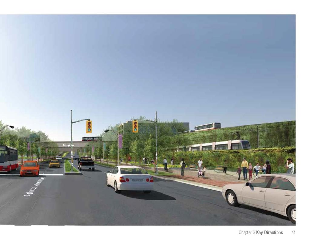
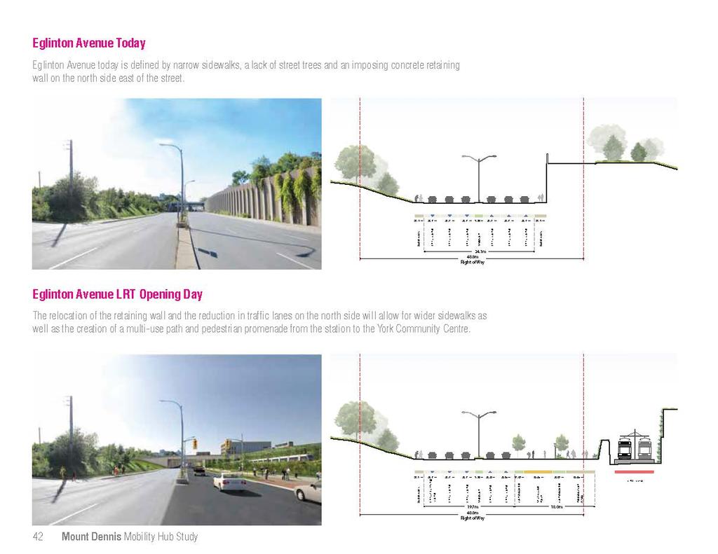
44 Black Creek Drive 3.2 Eglinton Avenue Eglinton Avenue Today Eglinton Avenue today is a wide, car-oriented street with little space or amenity for pedestrians. It is an important east-west connector through the Mount Dennis neighbourhood and the city. West of Keele, Eglinton transitions from a main street to a much wider arterial road that prioritizes the efficient movement of cars. Here, six lanes of traffic and up to two turning lanes transform the street into a fast moving thoroughfare that divides the north and south sides of the street. With the exception of one block west of Weston Road, there are no buildings fronting onto Eglinton Avenue in the study area. Despite the fact that Eglinton connects the Black Creek and Humber Valley systems, there is little to indicate this relationship. Sidewalks are generally narrow and unwelcoming for pedestrians and there is no sidewalk on the north side of Eglinton between Jane and Weston Road. The Eglinton West Trail which runs along the south side of Eglinton does not extend east of Jane Street. East of Weston Road there are few street trees or pedestrian amenities. A large retaining wall along the north side of the street between the rail corridor and Black Creek Drive creates a particularly harsh environment for pedestrians. At the intersection of Weston Road and Eglinton Avenue, in the heart of the community, dedicated and channelized turning lanes create long crossing points for pedestrians. Weston Road Ray Avenue 3 Eglinton Avenue Mount Dennis Mobility Hub Study


45 1 2 The main street condition that exists along much of Eglinton Avenue does not exist west of Keele Street 3 Dedicated turning lanes on top of 6 traffic lanes creates an unfriendly pedestrian environment at Black Creek Drive and Eglinton 4 There is currently no sidewalk on the north side of Eglinton Avenue east of Jane A view of the Kodak Building, retaining wall, and Eglinton Avenue as it passes under Photography Drive Chapter 3 Key Directions 35
46 Eglinton Avenue Tomorrow Major Themes From Public Consultation Over the course of the mobility hub study there were a range of ideas shared with the team regarding the future of Eglinton Avenue. These included: Design the station as a destination for the Community Improve the underpass condition for pedestrians and cyclists Improve the parks on either end of Eglinton Extend the multi-use path between Jane and the Community Centre Improve the streetscape to make the street more enjoyable Minimize traffic impacts What Changes Will Occur? As Eglinton Avenue becomes a transit street, surface movement will shift from being predominantly caroriented to being more supportive of a balance of movement that includes pedestrians and cyclists. Between Pearen Street and Black Creek Drive, a reduction in vehicle lanes will create space for wider sidewalks and streetscape enhancements. Closer to Black Creek Drive, the need to rebuild and relocate the large retaining wall on the north side of Eglinton will create additional opportunities to enhance the image of the street. As the market changes over time, significant redevelopment may be possible at the south west corner of Black Creek Drive and Eglinton Avenue (the Black Creek Triangle). What Do We Want to Achieve? Eglinton Avenue will be an important connection for pedestrians and cyclists between Jane Street and Black Creek Drive, and a key contributing component of the open space and public realm network. Significant streetscape improvements including trees, pedestrian amenities, and a multi-use path, will stitch the two valleys together. At the station, the redesigned retaining wall will help to further enhance the character of the street through the application of special design treatments and create a wide promenade connecting passengers with the new York Community Centre. New development on Eglinton Avenue, including LRT and station infrastructure will contribute to the public realm improvements on the north side of the street through more generous set-backs and planting. 36 Mount Dennis Mobility Hub Study


47 The existing multi-use path that ends at Jane Street should be extended to the new community centre. Generous landscaping will create a true green promenade Lights and public art can transform underpasses Re-naturalized park space at the Keelesdale Road area will enhance the existing park system Streetscape plans must include pedestrian amenities such as seating, lighting, and street trees. A generous, tree-lined path along Eglinton Avenue could help support families traveling between the station and the York Community Centre (flickr: Visit Btown) Chapter 3 Key Directions 37

48 6 Key Strategies For Eglinton Avenue Extend the Multi-Use Path at Jane to the New Community Centre Create an Eglinton Greenway Mount Dennis Station Pearen Park Pearen Street Eglinton Avenue Weston Road Fergi Brown Park Guestville Ave Eglinton Flats 38 Mount Dennis Mobility Hub Study

49 Create a Feature of the Station Wall Renaturalize the Black Creek Valley Coronation Park Kodak Building No 9 Eglinton Avenue Black Creek Drive York Community Centre Keelesdale Park Photography Drive Create a Light and Airy LRT Overpass Provide an Accessible Secondary Entrance Chapter 3 Key Directions 39

50
51
52

53
54


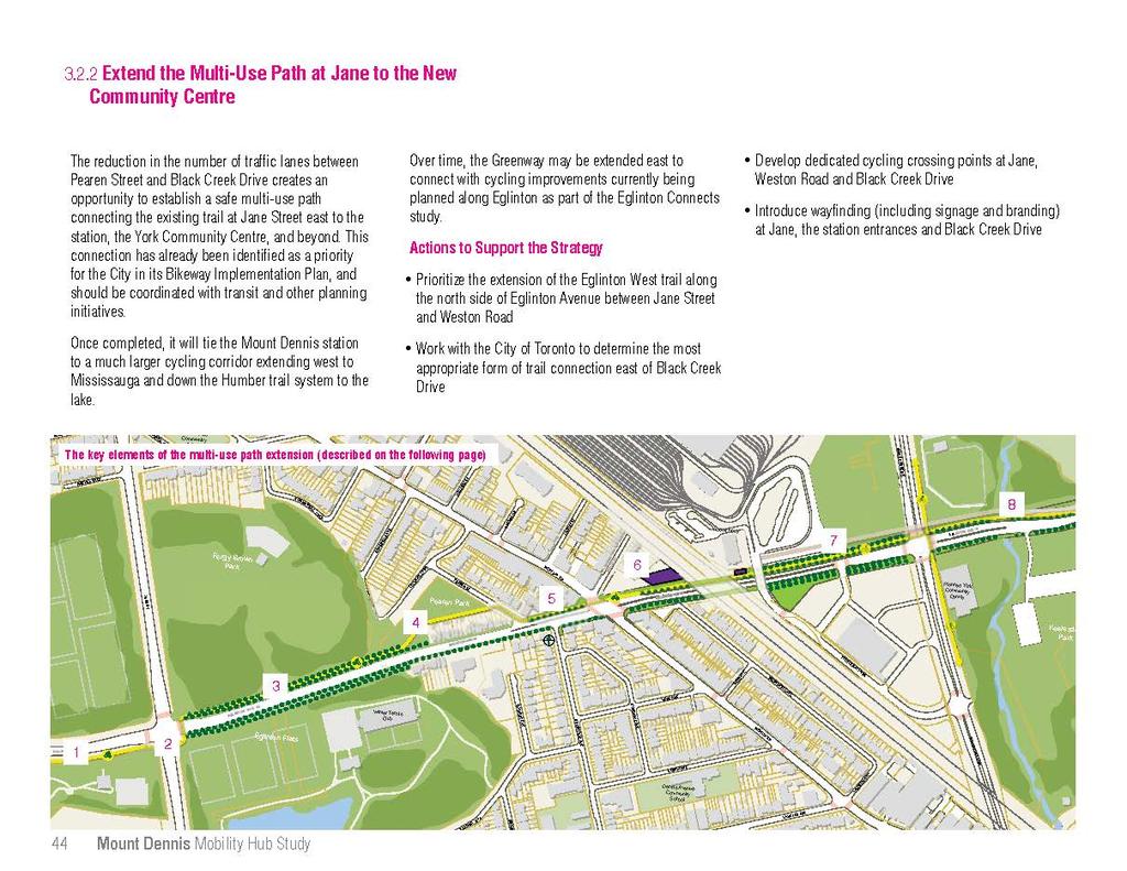
55 The Existing Eglinton Multi-Use Path Across Dedicated Bike Crossings Along the North Side of Eglinton Through Pearen Park The existing multi-use path on Eglinton terminates at Jane Street. From Jane it runs west to Mississauga connecting with the Humber River trail on its way. At Jane Street, a pair of cycling activated crossing points could help cyclists travel to the northeast corner of the intersection. The extended multi-use path could run along the north side of the Eglinton right of way on the north side of the trees. The path could run along the southern edge of the baseball diamond between a colonnade of trees to connect with Pearen Street due to insufficient room for a multiuse path on Eglinton in this section Along a Reclaimed Merging Lane The Station Along the Eglinton Promenade Along the North Side of Eglinton Between Pearen Street and the station, the multi-use path could run along an area that is currently being used as a merging lane but is no longer needed. The Weston Road Station Entrance will contain enhanced bike facilities including secure indoor bike parking for cyclists. East of the rail corridor a secondary entrance will contain outdoor sheltered bike parking. From the Secondary Entrance the path could run alongside the proposed pedestrian promenade to the community centre and a future trail on Black Creek. East of Black Creek Drive, either a multiuse path or bike lanes could be provided to connect to the broader cycling network planned by the City. Chapter 3 Key Directions 45


.")


56 3.2.3 Create a Feature of The Station Wall In order to construct the LRT beneath the rail corridor, the existing retaining wall along the north side of Eglinton Avenue must be removed. A new retaining wall will need to be rebuilt north of the LRT trackway, including a protective structure between the LRT trackway and the new sidewalk on Eglinton. This creates an opportunity to provide more generous pedestrian environment and create a feature of the new retaining wall that can enhance the image of Eglinton Avenue. While the Mobility Hub Study examined multiple strategies including the creation of an art wall (1) and a glazed structure over the tracks (2), none has the potential to assist in transforming the image of Eglinton Avenue more than the development of a planted retaining wall system (3). 1 Art Wall 2 Structure The creation of a planted retaining wall along the north side of Eglinton would help to extend the green characteristic of the Black Creek Valley west along Eglinton Avenue and create the unique experience for transit riders of exiting the portal west of Keele and traveling over Black Creek Drive through a lush landscape into the Mount Dennis Station. There are a number of systems for the creation of a planted retaining wall including the use of stacked concrete bins filled with plants and soil, wire and cage systems to enable plants to grow up the wall, and terraces that allow plants to cascade down the sides of the retaining wall. Consideration should be given to the long term maintenance of the wall with preference given to systems that employ low-maintenance materials which bloom early and last late into the fall, and remain attractive in the winter. Actions to Support the Strategy Explore the integration of a planted retaining wall along the north side of Eglinton 46 Mount Dennis Mobility Hub Study 3 Planted (Mayr Ludescher Partner) (SSL Innovative Construction Products)


57 3.2.4 Provide an Accessible Secondary Entrance While the primary entrance to Mount Dennis Station will be located at the corner of Weston Road and Eglinton Avenue, there is an identified need for a secondary entrance at grade on Eglinton Avenue to serve new development on the Black Creek Triangle, the new community centre, and valley parks at Black Creek Drive. Kodak Building No 9 Eglinton Avenue Secondary Entrance Building Photography Drive As the primary entrance between the station and York Community Centre, the entrance should be designed to be fully accessible and set back sufficiently to preserve adequate space for the multi-use path and street plantings of the Eglinton Greenway. An opportunity also exists to help animate the Photography Drive underpass and enhance the environment of the station by creating a highly glazed structure that will bring light into the station during the day and act as a lantern along the street at night. A secondary station entrance structure fronting on to Eglinton and spanning under the new Photography Drive bridge An interesting and welcoming secondary entrance building that creates a unique feature along the street Glazing and passenger amenities such as real-time train information create an inviting environment in this fully-accessible secondary entrance Chapter 3 Key Directions 47


58 3.2.5 Re-naturalize the Black Creek Valley Potential Storm Water Management Pond The closure of Keelesdale Drive to accommodate the LRT overpass provides an opportunity to re-naturalize this western section of the Black Creek Valley area. Along with natural vegetation and storm water management ponds, the design of the area should include paths that connect up to the Black Creek Business Park and fully integrate the site into the larger valley park system. Pedestrian Path Black Creek Drive Coronation Park Eglinton Avenue Keelesdale Park Actions to Support the Strategy York Community A re-naturalized Keelesdale Road area would extend the existing park system across Black Creek Centre Road and engage with the station area. If all stormwater cannot be treated on site, explore the potential to store stormwater from the Maintenance and Storage Facility in a naturalized Storm Water Management Pond on the existing site of Keelesdale Drive Explore the potential of designating the Black Creek Valley a Community Action Site and working with the TRCA to re-naturalize the area over time The Keelesdale Road area today is heavily vegetated A naturalized storm water management facility in the valley has the potential to become a unique destination for walking within the valley Trails and paths could be provided to connect the Black Creek Drive and Eglinton Avenue intersection with the Black Creek Business Park 48 Mount Dennis Mobility Hub Study


59 3.2.6 Create a Light and Airy LRT Guideway The elevated guideway over Black Creek Drive will be a significant structure that is highly visible for people passing through the area or making use of the valley lands and new community centre. The design of the structure should strive to reduce its actual and perceived size in order to minimize the impact of the guideway on its surroundings including the future pedestrian and cycling path adjacent to it. While minimizing the appearance of the guideway through its design and engineering will be important to achieving a light and airy structure, an opportunity also exists to celebrate the structure and the dynamic image of the LRT passing overhead through the use of public art. This could take the form of patterns applied to the structure or through the use of lighting which could be manipulated to change over time or when an LRT is passing by. Actions to Support the Strategy Explore the use of a more streamlined structure, such as a single box structure A transit overpass in Vancouver accommodates a multi-use path beneath it (flickr: buzzerblog) Maximize the transparency of railings atop the structure so that it looks slimmer Explore guideway treatments that reflect the aesthetic of the station Work with the local community to identify a public art strategy for the structure New LRT Guideway Coronation Park Eglinton Avenue York Community Centre Keelesdale Park Black Creek Drive The LRT overpass with fly-over Black Creek Drive, through two parks, and past a new Community Centre. Chapter 3 Key Directions 49

60 3.3 Weston Road Weston Road Today Weston Road is the historic main street for the Mount Dennis Community and characterized by a mix of primarily two-storey mixed use main street and residential development. While Weston Road was once a more significant commercial destination for the community, the vitality of the street has suffered substantially over the last 20 years, a victim of declining local employment, reduced incomes in comparison to other areas of the city and competing retail uses located to the south and north of the station area. Today many of the shops along the street are vacant and some former retail spaces have been converted to residential uses. Where larger parcels of land have been assembled, main street buildings are being demolished and replaced by low-rise townhouse developments facing the street. This has led to a reduction in street life and eyes on the street which contributes to the sense of a lack of safety for area residents. In contrast to many of the city s retail main streets, there are currently no street trees along Weston Road. This is a result of overly generous lane widths which leave little room for planting along sidewalk and boulevard. Dedicated turning lanes at Eglinton Avenue create long crossing distances for pedestrians. In recent years, parts of the street have seen investment in new street furnishings including smaller planter boxes, pedestrian lighting and hanging baskets. Black Creek Drive Ray Avenue 4 Eglinton Avenue Weston Road 50 Mount Dennis Mobility Hub Study


61 1 2 4 In places, new townhouse development has replaced mixed-use buildings along Weston Road 3 Recently implemented streetscape improvements The Mount Dennis Community Centre 5 The Weston main street today still has the traditional retail form The Weston and Eglinton Intersection is a wide crossing for pedestrians Chapter 3 Key Directions 51
62 Weston Road Tomorrow Major Themes From Public Consultation Over the course of the mobility hub study there were a range of ideas shared with the team regarding the future of Weston Road. These included: Preserve Weston s main street function Enhance the public realm to make the street more welcoming Design the station park as a destination Enhance pedestrian crossings to make it safer to cross the road Incorporate lighting into the station to improve safety What Changes Will Occur? The introduction of enhanced transit to Mount Dennis is not expected to have an immediate impact on Weston Road. Instead, a gradual improvement to the residential market driven by buyers looking for affordable housing with good access to transit and amenities will lead to improvements in the viability and quality of Weston Road retail over time. As the market changes, the evolution of Weston Road could be supported by a range of initiatives including improvements to the look and character of the street and an increase in employment and residential densities that can help to improve retail demand. Success over the long-term will be dependent on establishing an enjoyable pedestrian environment with locally based shops that provide a unique retail offer. What Do We Want to Achieve? Weston Road will be preserved as the neighbourhood "main street," with a vibrant retail core enhanced by consistent streetscaping, new green space and, in the longer term, wider sidewalks with trees. While much of the street should remain low-rise, welldesigned mid-rise buildings on larger parcels will help add more people and uses. Closer to the station a new park will become a focal point for the neighbourhood, animated by new development that also provides amenity for transit riders. 52 Mount Dennis Mobility Hub Study


63 Safe pedestrian crossings with narrow turning radii New development that increases pedestrian activity and helps to support retail Improved streetscape with street trees that can help to make the street more inviting Preserved main street buildings that can support new retail uses over time Chapter 3 Key Directions 53

64 7 Key Strategies For Weston Road Anchor the Station with New Development Encourage Mid-Rise Development along Weston Road Create a Series of Small Open Spaces Bartonville Avenue Ray Avenue Weston Road Eglinton Avenue Somerville Avenue Pearen Park Create a New Mount Dennis Park 54 Mount Dennis Mobility Hub Study

65 Coronation Park Keelesdale Park Preserve for New Retail Uses on Weston Road Black Creek Drive Transform the Southern Entrance to the Community Barr Avenue Weston Road Jasper Avenue Enhance Streetscapes and Widen Sidewalks Lambton Avenue Dennis Avenue Community School Chapter 3 Key Directions 55

66 3.3.1 Anchor the Station Entrance With New Development On opening day, a new station entrance will be provided on the north side of Eglinton Avenue just west of the GO Rail corridor, with a walkway providing access to the corner of Weston Rd and Eglinton Avenue. Because the Scotia Bank building at 1151 Weston Road may be retained in the near term, it is important for the new station entrance and walkway to be designed to maximize visibility and access from the Mount Dennis neighbourhood to the west. Over time, it is recommended that 1151 Weston Road and adjacent properties support more intense land uses given their proximity to the station. This will help to support the Mobility Hub Study objectives, create an opportunity to add more people and uses to the station area and enable the development of a new park (see section 3.3.2) at the intersection of Weston Road and Eglinton Avenue. Actions to Support the Strategy Ensure the design of the station entrance helps to reinforce sightlines to and from Weston Road Tree plantings, signage and pedestrian lighting should be organized to reinforce the connection to and from Weston Road and designed to compliment the design language of the station so that the entrance is recognizable from the street Establish a site and area specific policy to require: a comprehensive assembly, development concept, and zoning implementation for the redevelopment of the entire station block that incorporates the design and placement of the station building, the possible integration of the Scotia Bank building and a new public park at Weston Road in whole or in part Design the station building to anticipate and support the redevelopment of the lands through the careful siting of station servicing, the station entrance and mechanical vent shafts Ensure taller buildings are designed to transition in scale down to low-rise neighbourhoods through the use of angular planes and podiums 56 Mount Dennis Mobility Hub Study Anchor the Station Entrance With New Development Hollis Street Weston Road Kodak Building No 9 Primary Entrance Eglinton Avenue Opening Day Connecting to the Station Entrance On opening day the new station will be constructed to the rear of the Scotia Bank along Eglinton Avenue. New streetscaping should seek to enhance station visibility and access by establishing a generous pedestrian promenade between the station entrance and Weston Road. This should be supported by streetscape elements such as pedestrian oriented lighting, seating and tree plantings which are coordinated to reflect the architectural language of the station and its surrounding open spaces.

67 Kodak Building No 9 Primary Entrance Eglinton Avenue Hollis Street Scenario A Small Mixed-Use Development to Face the Park Weston Road Over the long term, if the Scotia Bank property is amalgamated with the lands required for the construction of the station entrance it would be large enough to accommodate a small infill project of between three and four stories in height and preserve for the creation of a new public park at the intersection of Weston Road and Eglinton Avenue (pg 59). Redevelopment at this scale should help to enhance visibility and access to the station entrance and provide new active uses facing the Park without impacting upon the existing housing next to the station. Chapter 3 Key Directions 57

68 Kodak Building No 9 Mount Dennis Station Eglinton Avenue Hollis Street Scenario B Integrating Taller Buildings to Landmark the Station Entrance Weston Road Alternatively, if all the properties along the south side of Hollis Street are acquired by a third party and consolidated with the station lands through a partnership with Metrolinx, the site would be large enough to contain a more significant building with a podium and high-rise component. The additional density would likely benefit retail in the surrounding area and help to increase safety through additional eyes on the street. This type of development would create an opportunity to be integrated with the station entrance. Development at this scale should help to enhance visibility and access to the station entrance and transition in scale down to Hollis Street to re-complete the street. 58 Mount Dennis Mobility Hub Study


69 3.3.2 Create a New Mount Dennis Park/Public Square Should the site of the Scotia Bank be redeveloped, an opportunity exists to develop a new larger public park at the entrance to the station. A green space fronted by active uses The new open space should be designed to function as the forecourt to the station entrance, connecting passengers between the station and Weston Road. As such, the treatment of the space and its furnishings should be complimentary to the design of the station entrance and include elements such as pedestrian oriented lighting, seating and waste receptacles. The design should include both hard and soft landscaping but overall should seek to create a green space with generous plantings and clusters of trees that will help to reinforce the image of an Eglinton greenway and provide a pleasant place to linger along Weston Road. Weston Road Hollis Street A new park at Weston Road and Eglinton Avenue Eglinton Avenue Landscaping in front of parking Actions to Support the Strategy Should the lands surrounding the station be redeveloped, work with the land owners to establish a new public open space If a public open space is not achievable work with the owners to develop a publicly accessible open space designed to read and act as a neighbourhood open space Work with the local community and BIA to identify opportunities for the integration of public art Clusters of planting and pathways connecting to the station Chapter 3 Key Directions 59


70 3.3.3 Preserve for New Retail Uses on Weston Road Their is strong support amongst members of the Mount Dennis community to rejuvenate Weston Road as the local retail focus of the community. Ensuring that buildings preserve for retail uses along the street will be a key strategy to enable the street to restore its retail function. This will require that the current trend of permitting townhouses or conversion of retail spaces to permanent residential uses is stopped in areas where the traditional main street fabric is still intact. A poor retail market in the short-term can be mitigated through alternative strategies such as encouraging the occupation of retail spaces with galleries or permitting live/work arrangements that preserve for the return of full retail uses over time. Similar initiatives in Newcastle Australia have proven successful with this approach. A Renew Newcastle poster advertising the pop-up store and gallery spaces created in vacant storefronts. A similar strategy could be engaged in Mount Dennis. A temporary gallery in a vacant retail space A pop-up store The preservation of retail buildings in the Junction has enabled the street to be revitalized as the market improved Actions to Support the Strategy Develop a retail retention zone with supportive zoning that requires the provision of retail space at street level Where retail is unfeasible in the short term, ensure buildings are designed to support conversion Retail Retention Zone Pearen Street Weston Road Mixed-Use Infill Mount Dennis Station Eglinton Avenue Guestville Avenue Ensure that buildings preserve for retail uses in core areas (highlighted in red) 60 Mount Dennis Mobility Hub Study


71 3.3.4 Encourage Mid-Rise Development along Weston Road Weston Road Weston Road is designated by Toronto s Official Plan as an Avenue from Jane to just south of Eglinton Avenue. This designation encourages mid-rise buildings of 5-6 storeys that are designed to integrate with adjacent houses. Extending a similar supportive policy framework further south along Weston Road would help to make it easier to develop mid-rise buildings along Weston Road. This would help to increase activity over time, support more main street retail and enhance safety. Actions to Support the Strategy Mid-rise Infill Building Lambton Avenue Ensuring that there is a policy framework in place to support mid-rise development north and south along Weston Road would help to make it easier for larger redevelopment sites to develop with higher densities Consider reviewing zoning to support the existing site and area specific policy that permits 5 story buildings, south to Lambton Avenue Apply the mid-rise guidelines to new development to ensure that they integrate with adjacent low-rise areas Setback requirements stipulated by the Avenue designation would generally limit new mid-rise development to between 5 and 6 storeys along the street Chapter 3 Key Directions 61
72

73


74 3.3.6 Transform the Southern Entrance to the Community In contrast to the Weston Road main street to the north, the small employment area at the northeast corner of Weston Road and Black Creek Drive accommodates a mix of manufacturing/retail and service uses that serve a much broader area. Over time, it is likely that the north half of the employment area at Weston Road and Black Creek Drive will transition from manufacturing and service uses to residential uses. Future development should face the street and provide a road network that buffers residential uses, supports employment intensification south of Jasper and enables lands between Bushey and Lambton to redevelop as residential over time. Redevelopment and intensification of the employment lands should face Weston Road and accommodate parking at the side or rear of the building. Actions to Support the Strategy Redevelopment of the employment areas should face the street and accommodate parking to the rear The north half of the triangle has the potential to transition to residential uses over time Investigate with land owners the development of a comprehensive redevelopment strategy for the lands east of Weston Road between Lambton and Black Creek. If a strategy is achieved, use the outcomes to inform zoning and OP amendments and assist in the review of development applications Brownville Avenue Residential Infill Consolidated Access Commercial Redevelopment Black Creek Drive Weston Road Redevelopment of sites in the triangle should establish a street and/or driveway network that supports the intensification of adjacent residential and employment areas over time 64 Mount Dennis Mobility Hub Study


75 3.3.7 Create a Series of Small Open Spaces While there is not much room on Weston Road for new green space or patios, there are a number of small underutilized spaces located at the side or corner of buildings where local streets meet Weston Road. Weston Road An opportunity exists to transform these side lots over time into small community gathering areas, cafe space or gardens. These new spaces could help to compliment local businesses by providing opportunities for spill-out uses or could be cared for and maintained by members of the community as a component of a neighbourhood greening initiative. Actions to Support the Strategy Oxford Street Denarda Street Work with the Mount Dennis BIA, residents and local businesses to identify, articulate and implement opportunities to transform underutilized side spaces over time Small underutilized spaces where side streets meet Weston Road have the potential to be transformed into new community spaces The side spaces could be greened as part of a community gardening/greening initiative Businesses should explore how side spaces could be used to support their activities with patios or business spill-out space (Flickr: Mad Mou) Chapter 3 Key Directions 65

76 3.4 Black Creek Triangle Black Creek Drive Coronation Park The Black Creek Triangle Today Kodak Building No 9 Eglinton Avenue 3 York Community Centre The Black Creek Triangle area is located at the southwest corner of Eglinton Avenue and Black Creek Drive. The site today is comprised of a large low cost grocery store to the rear with surface parking in front. To the north of the store is a vacant parcel of City-owned land facing Eglinton. To the south of the store is a vacant piece of land with a rezoning proposal for a gas bar. 1 2 No Frills Photography Drive 4 Although currently well-used as a grocery store, the site is large enough to support higher densities and a greater mix of uses. The site has historically been the subject of several larger scale proposals including the development of a new centre for the former City of York, and has zoning permissions in place for a significant number of new residential units. Ray Avenue Weston Road 66 Mount Dennis Mobility Hub Study


77 1 A view from the Kodak Building across the vacant City of Toronto site and grocery store 2 3 A view looking north up Black Creek Drive 4 A view of Photography Drive today There are large areas of surface parking in front of the grocery store Chapter 3 Key Directions 67
78 Black Creek Triangle Tomorrow Major Themes From Public Consultation Over the course of the mobility hub study there were a range of ideas shared with the team regarding the future of The Black Creek Triangle. These included: Provide safe pedestrian connections to the Station and Community Centre Encourage new mixed use development Provide a mix of housing types Ensure new buildings address the street Protect for a grocery store in this area in the future Support existing retail on Weston Road Create new streets and a new open space What Changes Will Occur? The scale of the Black Creek Triangle and its proximity to the station make it a key site for redevelopment over time, as transit is introduced and the market changes. Possibilities for development on a site of this scale may include residential, retail, hotel or office depending upon how the market matures. In the short-term, the market may limit redevelopment to complimentary retail uses and wood frame stacked townhouse development. A changing market will allow for higher density development to follow over the longer term, building on an improvement in the condition and value of the existing housing stock. What Do We Want to Achieve? The Black Creek Triangle will be transformed into a vibrant urban district with a mix of new uses and building types. New streets and blocks will help to create a more walkable environment for pedestrians and enhance connection to and from the station. While the buildings along Black Creek Drive and Eglinton Avenue will have a strong relationship to the Black Creek Valley, a centrally located public open space will provide a focus for new development and activity within the site. To mitigate the impacts at street level, tall buildings with bases that define and actively address the areas streets and open spaces. 68 Mount Dennis Mobility Hub Study


79 Ensuring new buildings address the street and relate positively to the park Ensuring buildings contain a mix of uses Creating a new open space in the site Providing shared parking Introducing new streets to support pedestrians Chapter 3 Key Directions 69
80 7 Principles to Guide The Evolution of the Black Creek Triangle 4.1 Establish A New Street and Block Pattern Establish a street and block pattern that can support a mix of uses and encourage higher levels of walking. Given the uncertainty of timing related to the redevelopment of the Black Creek Triangle it is difficult to predict the ultimate mix and form of uses. In order to ensure that new development helps to support transit ridership, improve access to the station and contribute to the broader aspirations of the station area, a series of seven principles to guide development in the Black Creek Triangle have been identified, which are applicable to any land use mix. The seven principles are illustrated in the following three development scenarios. Scenario A: Primarily Retail Scenario B: A Mix of Retail and Residential Housing Types Scenario C: Primarily Residential Actions to Support the Strategy Work with land owners to establish a site and areaspecific policy which reflects the 7 principles identified through the mobility hub study and the requirement for a plan of subdivision to establish a street and block pattern Use the site and area-specific policy to asses new development proposals for the area and ensure that they are supportive of long-term objectives 4.2 Establish A Neighbourhood Open Space Support new development with a neighbourhood scaled open space or plaza. 4.3 Design Buildings to Face The Streets Ensure that all new uses actively front onto streets with transparent facades and entrances. For larger retail uses this may require incorporating a mix of uses within the building some of which can face outwards while others face in to the site. 4.4 Accommodate Parking in Structures or Below Grade Accommodate the majority of parking below grade or in parking structures with active uses at street level. 4.5 Design Convenience Parking to Minimize Impacts Accommodate convenience parking on street where possible and ensure that smaller areas of convenience surface parking are designed so that they do not detract from adjacent streets or open spaces. 4.6 Permit Taller Buildings that Overlook the Valley Allow taller buildings on bases that can take advantage of views over the valley while providing spatial enclosure to streets and open spaces. 4.7 Preserve Space for A Secondary GO Entrance Preserve for a new GO entrance south of Eglinton that connects west to Barr Avenue in the west by setting back the building from the Photography Drive bridge. 70 Mount Dennis Mobility Hub Study
81 Coronation Park Eglinton Avenue Apartments Retail Apartments Black Creek Road York Community Centre Parking Open Space Apartments Retail Photography Drive Grocery Store Apartments Scenario A Primarily Retail This scenario illustrates what the site might look like if developed as a primarily retail area. Two structured parking lots, one on the City site and one to the south of the grocery store have enabled the redevelopment of the surface parking lot. A new large format store incorporates a mix of housing so that it can face Black Creek Drive and Eglinton Avenue. Several mid-rise and high-rise residential buildings overlook the park. Parking Chapter 3 Key Directions 71

82 Coronation Park Eglinton Avenue Apartments Apartments Grocery Store Apartments Black Creek Road York Community Centre Open Space Apartments Retail Photography Drive Townhouses Scenario B Mix of Retail and Residential Housing Types This option illustrates what the site might look like if developed with a mix of retail and residential uses. The existing grocery store has been shifted to the intersection and now incorporates a mix of residential. While most parking is accommodated below grade, a small convenience parking lot associated with a pad retail store has been designed to minimize impacts on adjacent streets. Townhouses and mid-rise apartments with earlier market potential have been developed away from the station with higher density residential uses located closer to Eglinton Avenue. Apartments 72 Mount Dennis Mobility Hub Study

83 Coronation Park Apartments Eglinton Avenue Black Creek Road Apartments York Community Centre Retail Photography Drive Open Space Apartments Apartments Apartments Scenario C Primarily Residential The primarily residential option illustrates what the site might look like as a high density residential development. Taller apartment buildings atop street defining bases overlook the valley. A modest stand-alone retail store is located alongside Eglinton Avenue where it is easily accessible from both the station and area housing. A new open space helps to enhance the connection from the station to the centre of the site. Chapter 3 Key Directions 73

84 3.5 Black Creek Business Area The Black Creek Business Area Today The Black Creek Business Area today is an employment manufacturing district consisting primarily of low-rise, light industrial buildings. The area is located just north of the planned Maintenance and Storage Facility, to the west of Black Creek Drive, The area is highly car-oriented with wide roads and narrow sidewalks, a proliferation of surface parking in front of buildings, and a lack of cycling facilities. Although there are a number of bus routes running through the area, transit waiting facilities are small or overgrown with weeds. The demolition of the Kodak site has turned Industry Street into a one-sided street. Low vacancy rates make the Black Creek Business Area a key stable employment area. However, the format of existing buildings (low clear-heights and relatively small floor plates) combined with the low demand for new industrial space in this area suggest that uses will diversify over time. Newer development in the area includes a Post Canada facility as well as a TTC Bus Barn. Todd Baylis Boulevard Industry Street Black Creek Drive 4 Bertal Road 3 Ray Avenue Mount Dennis Mobility Hub Study


85 1 2 The Ray Avenue connection to Weston Road has few pedestrian or cycling amenities 3 An overgrown transit waiting area on Industry Street The recently completed TTC Bus Barn with improved sidewalks 5 4 A crowded transit waiting area at Ray Street and Industry Street Low-rise auto oriented development along Industry Street Chapter 3 Key Directions 75
86 Black Creek Business Area Tomorrow Major Themes From Public Consultation Over the course of the mobility hub study there were a range of ideas shared with the team regarding the future of The Black Creek Business Area. These included: Maintain existing employment uses Provide shops and cafés for employees Add bike lanes to protect cyclists Add sidewalks and improve the streetscape Development should face the street Animate the area through new uses What Changes Will Occur? The low ceiling heights and small building footprints of the Black Creek Business Area mean that it is currently attractive to industrial tenants seeking low rents and operating costs. Because of this, the shift towards a focus on storage, light manufacturing and business service that the area is experiencing is likely to continue. While there may be a potential future market for retail-employment within a warehouse environment, any accommodation for this transition must be considered through a future Official Plan municipal comprehensive review of employment land designations and policies. Opportunities should be pursued to increase the level of amenity for employees and visitors through the provision of improved streets and sidewalks, buildings that address the street, cycling facilities and new open spaces. What Do We Want to Achieve? The Black Creek Business Area will remain a key employment area for the neighbourhood. Improvements to the pedestrian realm and the addition of dedicated cycling lanes will support employees by making it easier to walk or cycle to work, as well as to reach area amenities. These enhancements will be augmented by the addition of small cafés or other services and a new open space that will provide amenity for employees at lunch or after hours. While the site area is fairly mature and for the most part developed, new buildings or renovations to existing buildings will face the street and contribute to a better pedestrian experience. 76 Mount Dennis Mobility Hub Study

 Cycling facilities should be")


87 New buildings should have a public face to the street New buildings should have a public face to the street (reginaurbanecology.com) Cycling facilities should be provided on major streets The provision of a new open space would help to provide amenity for area employees during lunch or after work Chapter 3 Key Directions 77

88 5 Key Strategies For The Black Creek Business Area Provide New and Enhanced Sidewalks Line Industry Street with New Buildings that Address the Street Encourage New Amenities for Area Employees Industry Street Ray Avenue Support Cyclists along Industry Street and Ray Avenue Establish a New Open Space for Area Employees 78 Mount Dennis Mobility Hub Study


89 3.5.1 Provide New and Enhanced Sidewalks Sidewalks will be key to improving the comfort and accessibility of the Black Creek Business Area as it evolves. Sidewalks should be provided where there are none, such as along Bertal Road. Along Industry Street, sidewalks and streetscaping should be improved over time and in conjunction with new development to provide a treed boulevard which will act as a buffer against larger truck and bus traffic. Street and sidewalk improvements around a transit station in Washington, DC, make the pedestrian experience much more comfortable and safe (planitmetro.com) Actions to Support the Strategy Conduct an audit of existing sidewalks throughout the business park to identify gaps where new sidewalks should be provided and areas where existing sidewalks should be improved Incorporate sidewalk enhancements in planned street and capital work projects for the area A robust treed boulevard and improved sidewalks would re-balance the street for more pedestrian comfort Chapter 3 Key Directions 79

 Bike lanes can make cycling safer and improve the pedestrian environment by providing a buffer between")

90 3.5.2 Support Cyclists Along Industry Street and Ray Ave Industry Street and Ray Avenue already act as informal cycling connections between Mount Dennis and the City of Toronto s suggested cycling route along Trethewey Drive. Where space permits, dedicated cycling lanes should be accommodated to make the street safer to share with trucks and busses. In areas where the street is too narrow to accommodate dedicated cycling lanes, the provision of sharrows can help to notify vehicles of the potential for cyclists and increase awareness. Designated cycling lanes can provide a safe space for cyclists on busy streets (flickr: Luton) Bike lanes can make cycling safer and improve the pedestrian environment by providing a buffer between the sidewalk and traffic (flickr: Luton) Actions to Support the Strategy Work with the City to explore the potential for signed or dedicated cycling facilities on Industry Street and Ray Avenue to connect with the suggested cycling route along Trethewey Drive and planned long-term path connection along Black Creek Drive A range of cycling amenities, including sharrows and dedicated bike lanes, could work together to make the area safer for cyclists (letsgorideabike.com) 80 Mount Dennis Mobility Hub Study


91 3.5.3 Encourage New Amenities for Area Employees There are few amenities in the Black Creek Business Area today for employees such as cafés and restaurants. The inclusion of such publicly accessible ancillary uses in new development and creation of them in existing buildings is strongly encouraged to give employees a range of options that are accessible by foot or bike. New amenities will help to minimize dependance on the automobile to access services and help to support local residents wishing to walk or cycle to work. Actions to Support the Strategy Support zoning-bylaw amendments to facilitate+ the amenitization of the Black Creek Business Area over time A small corner store caters to drop-in shoppers in an employment district (goodfoodshops.com) Restaurants and cafés could be provided in new buildings and with major redevelopment projects (Forestridge Business Park) Supporting outdoor seating areas and cafe s can help to create a more enjoyable employment environment during warmer summer months Chapter 3 Key Directions 81


92 3.5.4 Establish a New Open Space Area for Employees One of the major concerns heard about the Black Creek Business Area was the current lack of open space for the casual gathering of area employees. The City should work with developers of larger sites in the area to provide a new small- to mid-sized open spaces that can serve employees at lunch. A preferred site identified through the course of the mobility hub process was at the corner of Industry Street and Ray Avenue where the space could be easily accessed by area employees and create a more comfortable waiting environment for transit users. Alternatively their may be the potential for a new open space on the south side of Industry Street if space exists on the MSF lands. Actions to Support the Strategy A new open space for area employees should provide ample green space and seating to accommodate lunch and break-time activities. Work with developers of larger sites within the area to provide a new publicly accessible open space for area employees through the planning approvals process This space could be privately or publicly maintained Industry Street Ray Avenue New Open Space A new open space could be designed as part of a larger development or redevelopment project. It should be centrally located and highly visible to serve a maximum amount of employees 82 Mount Dennis Mobility Hub Study


93 3.5.5 Line Industry Street with New Buildings that Address the Street As the area redevelops over time, new buildings should be oriented to face the street. To increase visual interest and comfort for pedestrians, entrances, amenities, and other active uses should be included in the street face. Parking for new and renovated buildings should provided to the rear or side of the building. Industry Street MSF Facility designed to face the street Actions to Support the Strategy Ensure that new buildings actively address the street and encourage parking to the rear or side of the building through the site plan approvals process Buildings should have a public face to the street with large amounts of transparent glazing material to increase interest at pedestrian level. New buildings, including any on the MSF site, should address the street to create a consistent street wall Employee cafeterias may be opened to the public providing a restaurant-style amenity for area employees. (Guildford Business Park) Chapter 3 Key Directions 83


94 3.6 Opening Day And the Long Term Vision The Construction of the station for opening day will result in a range of improvements to the Kodak Lands and along Eglinton Avenue. Over time, the opening day improvements and ongoing investment in the community will help to set the stage to achieve the long-term vision for the station area. Passenger Pick Up & Drop Off With Kodak Parking Rebuilt Intersection with Improved Crossings Primary Entrance Rebuilt Streetscape & Multi-use Path Between Weston and Black Creek Kodak Building Bus Terminal Relocated Retaining Wall With Special Treatment New Photography Drive Bridge Fergy Brown Park Multi Use Path Station Park GO Station Secondary Entrance Eglinton Flats Opening Day The Long Term Vision 84 Mount Dennis Mobility Hub Study
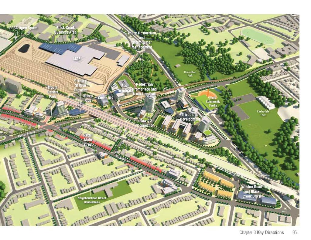
95

96 86 Mount Dennis Mobility Hub Study

97 Enhancing Access 4 Chapter 4 Enhancing Access 87
98 4.1 Enhancing Access For Pedestrians and Cyclists Making it easier to walk or ride to the station will be important to enhancing its relationship to the community and supporting access and transfers in and around the station area. A map illustrating the proposed pedestrian and cycling improvements can be found on page 102. Establish A Station Priority Area Eglinton Avenue between Weston Road and Black Creek Drive will be an important place of movement within the community, supporting people walking and cycling to and from the station, passenger pickup and dropoffs and travel between the neighbourhood, station and York Community Centre. The establishment of a Station Priority Area with a higher level of pedestrian and cycling amenity along this stretch of Eglinton will be an important strategy to help to support access in and around the station and enhance safety for station users. Key Strategies to Support The Opportunity Establish a Station Priority Area (see page 102) along Eglinton Avenue that captures the intersection at Black Creek Drive and Weston Road. Target the Station Priority Area with a higher level of pedestrian and cycling amenity including pedestrianscaled lighting, bike posts, waste receptacles, seating and wayfinding signage. Work with the local community and BIA to develop a public art strategy for the Station Priority Area. Eliminate channelized turning lanes, reduce turning radii and introduce distinct crossing treatments to make it easier to cross the street within the priority area. Make it Easier to Walk To and From The Station The principle form of access to the station for people living and working within Mount Dennis will be as pedestrians. These users will travel along the most direct streets leading to and from the station as well as the primary streets around the station. The condition of sidewalks throughout the station area varies substantially. In some areas, the sidewalks are generous and in good condition, while in others the sidewalks are narrow, overgrown or non existent. In order to support access to and from the neighbourhood, the condition of key sidewalks and crossings leading to and from the station should be catalogued and enhanced as needed. Key Strategies to Support The Opportunity Work with community representatives to identify key neighbourhood streets leading to and from the station and target these streets for sidewalk and streetscape enhancements over time. Suggestions include along Dennis and Guestville Avenues which would help to enhance access for the areas schools, and along Bartonville and Lambton Avenues which are important east-west connectors. Over time, Barr Avenue may be an important connection following the introduction of a secondary GO entrance south of Eglinton. Identify and fill gaps within the sidewalk network. Introduce zebra striping at key intersections and crossing points leading to and from the station. Initiate underpass enhancement along key routes to improve the experience of walking beneath the bridges. 88 Mount Dennis Mobility Hub Study


99 Enhance Access for Cyclists The extension of the Eglinton West trail from Jane Street to Black Creek Drive (see page 44) will position Mount Dennis Station as an important hub within the City s regional cycling network. Once completed, it will be possible to ride from Mount Dennis along a separated pathway west to the City of Mississauga and/or down the Humber River or east along a reconstructed Eglinton Avenue to the Don River. In addition to reinforcing Mount Dennis as an important cycling hub, the creation of a network of cycling routes in and around the station area will help to connect people to the station who are too far to walk and improve access to the neighbourhood s valley systems. This network should be supported by enhanced cycling facilities at the station that include both secure, longer term parking, sheltered short-term parking and service amenities Key Strategies to Support The Opportunity Incorporate a range of bicycle parking options at the station including a secure sheltered parking area and sheltered short-term parking. Explore opportunities to provide additional cycling amenities such as a repair stand and bike pump within the station plaza or station to support cyclists. In addition to the Eglinton West Trail extension, develop an on-street cycling route connecting Pearen Park through the Black Creek Business Park to Trethewey Drive in the north. Preserve For a Secondary GO Entrance In the short-term the GO station will be accessed via a concourse connection between the Kodak building and station entrance on Weston Road. Over the longer term, an opportunity may exist for the creation of secondary entrance that stretches beneath the rail corridor between Barr Avenue with Eglinton Avenue to the east. A new entrance in this location would help to better connect the station to the neighbourhood and create a more direct route between Weston Road south of Eglinton Avenue and the planned York Community Centre. Key Strategies to Support The Opportunity Initiate a technical study to determine the optimal location and configuration of a new secondary entrance between Barr Avenue and Eglinton Avenue. Design the GO Station platforms to preserve for the creation of the secondary entrance over time. Ensure redevelopment of the City s land within the Black Creek Triangle either steps back from Eglinton Avenue to Photography Drive to preserve for the extension of the secondary entrance or incorporates a secondary entrance and connection to Photography Drive into it s design. Design the future connection between Photography Drive and the south side of Eglinton to include both stairs and accessible ramping and make it generously landscaped so that it can contribute to the image of an Eglinton greenway. Photography Drive Eglinton Avenue Barr Avenue Secondary GO Entrance View illustrating the secondary GO entrance from Eglinton Eglinton Avenue Secondary GO Entrance Chapter 4 Enhancing Access 89
100 4.2 Supporting Access By Vehicles While enhancing access for pedestrians and cyclists will be important to supporting transitridership, providing access for vehicles in and around the station area will continue to be an important part of providing a balanced mobility network. Support Passenger Pick-up and Drop-off Estimation of an appropriate number of Passenger Pick-Up/Drop-Off (PPUDO) spaces is difficult given the dynamic transfer activity expected. While frequent LRT service would be expected to result in a high turnover rate for PPUDO traffic, thereby reducing the requirement for longer-duration parking spaces, GO service, with its set arrival times, requires space for waiting vehicles. If no formal facilities are provided for quick stops, drivers will likely stop curbside to drop-off passengers, forming an ad-hoc Kiss and Ride operation. Conversely, an off-street PPUDO may be a more preferable location for drivers waiting to collect passengers from the GO Train. In order to cater to these varying needs, a combination of both on-street PPUDO facilities and off-street PPUDO facilities have been identified. A small number of curbside, short-term parking bays for PPUDO purposes have been identified for Eglinton Avenue. These will provide a convenient stopping location for motorists; however, they offer no opportunity to turn around or recirculate to another parking space should the limited parking spaces be occupied. For drivers with longer waits, a small PPUDO facility has been provided adjacent to the Kodak Building. This would be accessed via Photography Drive and provide space for both quick stops and longer waits associated with GO transit users. Minimize Traffic Impacts on Existing Neighbourhoods Depending on the long-term evolution of the station area and patterns of development that occur, there may be potential for increased traffic diversion due to the reduction in level-of-service on Eglinton Avenue. While it is expected that most diversions will likely occur beyond the local road network (i.e. around the neighbourhood on other major arterials), there may also be the potential that residents and employees of the Mount Dennis area will infiltrate through the local road network in order to avoid points of congestion. There are a number of measures to manage traffic infiltration and mitigate the impacts of traffic diversion. Traffic impacts on existing neighbourhoods should be monitored following completion of the station and measures to mitigate against those impacts implemented as required. 90 Mount Dennis Mobility Hub Study
101 Manage Parking In order to maintain the best level of service possible for traffic operations up to and beyond the 2031 time horizon, there will be a need for the City to promote nonauto modes within the Mount Dennis station area. There are a number of potential approaches that can be considered to manage the auto demand within the study area, including: Car Sharing: Encouraging developers to provide a car sharing service or subsidize a car share membership in or near residential developments provides residents easy access to a vehicle when needed and can reduce or eliminates the need for residents to own a primary or secondary vehicle. Paid Parking Strategies: Introducing paid parking at area parking lots in the Mount Dennis Mobility Hub could increase the ridership on the local feeder lines by reducing the amount of vehicles that would commute to area parking lots. Unbundled Parking: Separating the cost of parking for residents makes the significant cost of driving more apparent and may encourage residents to make more informed transportation decisions such as carpooling, car sharing, active transportation and transit. Shared Parking: Providing shared parking allows parking spaces to be shared by more than one user. Since many parking spaces will likely only used part time, implementing shared parking can take advantage of the unused parking spaces and use the area parking facilities more efficiently. Manage Traffic Over the Short and Long Term The technical analysis for the Mount Dennis station area indicates that the major intersections are currently operating at acceptable levels of service with delays of between 23 and 45 seconds depending upon the direction and time of day. In the short-to medium-term (5-10 years) the most significant impact to traffic within the station area will be a reduction in the number of lanes along Eglinton Avenue from 3 down to 2 in each direction. This will have the greatest impact on the Black Creek Drive and Eglinton Avenue intersection where a delay of an additional 10 seconds can be expected during the peak period. Traffic issues over the long-term will be tied to the levels of new development experienced in and around the station area. While real-estate market conditions to support development may not be present for as far as years in the future, a technical analysis based on a full build-out of redevelopment sites suggests that the most significant long-term impact will continue to be felt at the intersection of Black Creek Drive and Eglinton Avenue. Neither the medium or long-term traffic impacts are expected to be unacceptable for an urban environment. The technical analysis is based on the assumption of a higher percentage of non-auto users, comparable to other transit hubs in the city but was not able to account for potential increases in modal split based on the operation of the Crosstown line or on how travel behavior may be effected by the reduction in lanes on Eglinton which may result in diversions away from the area. The management of traffic around the station will rely on a suite of area improvements aimed at increasing the efficiency of the road network and encouraging higher levels of walking, cycling and transit ridership. Examples include: Pedestrian network improvements such as improved intersection geometry, new crosswalks and pedestrian connections; Cycling network improvements such as the extension of trails through the station area and introduction of onstreet cycling facilities; Transit network improvements including increased transit frequencies and enhanced real-time information services to improve decision-making; Parking management strategies as discussed above; and Road network improvements such as the implementation of new street connections that can help to spread traffic flows. Regardless of area improvements, the level of service for automobiles along Eglinton Avenue within the station area will decline. While many public concerns with respect to the review of new developments will relate to their traffic impacts, given that Mount Dennis is a designated Mobility Hub, a more balanced Mobility Impact Assessment should be encouraged for new development within the station area. This would measures the quality of service across all modes and encourage improvements to the pedestrian, cycling and transit network. This would help to shift the emphasis away from automobiles toward ensuring that new development supports an overall a higher level of balanced mobility within the station area. Chapter 4 Enhancing Access 91

102 92 Mount Dennis Mobility Hub Study

103 Implementation & Partnerships 5 Chapter 5 Implementation and Partnerships 93


104 5.1 The Changing Market Over Time The development of Mount Dennis station may not have an immediate impact on the market, however, over the longer term, increased access to fast reliable transit in combination with sustained community investment will help make the area more attractive for investment. Strengthening the Housing Market Increasing the Viability of Weston Road Although the housing market is currently unable to support new development, increased transit access provided by the Crosstown in combination with lower than average housing prices and public realm improvements will help attract new people to the neighbourhood. These new people will be drawn by the prospects of being able to afford family-sized housing in an attractive setting with convenient access via transit to amenities and jobs throughout the city. As demand increases, the viability of the residential market will also improve, making it possible for more and varied housing forms such as townhouse and stacked townhouse development. A strengthening of the residential market will help improve the Weston Road main street by introducing new people, with a mix of incomes and interests, into the neighbourhood. With sustained investment in the public realm, Weston Road will become increasingly attractive to local residents seeking the amenities, services and a main street retail environment similar to what can be found in other transit-supportive neighbourhoods. Small shop spaces and lower comparative rents will help to create an opportunity for local entrepreneurs seeking to fill the void and contribute to the ongoing improvement of the street. This could be further supported through local community economic development initiatives such as encouraging the transformation of vacant stores to cheap temporary gallery or restaurant spaces. 94 Mount Dennis Mobility Hub Study


105 TRANSIT INVESTMENT Attracting Higher Density Uses Diversifying Retail and Employment Uses Over the 15 to 25 year horizon, a strengthening of the housing market, gradual improvements to the public realm, and an increase in the number and quality of shops and services along Weston Road may help to strengthen the market sufficiently to make higher-density development viable. At first, small shops supported by transit users will likely be the most viable in the area immediately surrounding the station. As the residential market improves and densities increase, new retail uses on sites such as the Black Creek Triangle or on the ground floors of new midrise development will become increasingly viable. + Higher densities will help to increase the safety of the neighbourhood by improving the vibrancy of area streets and open spaces. It will also have a reciprocal effect on the viability of local businesses by helping to support a broader range of retail, restaurants, cafes and services. It is unlikely that new office uses will be developed in Mount Dennis in the next years. Over the longer term, enhanced transit access combined with new residential population and enhancements to the urban environment in the form of public realm improvements, new retail and services may help to enhance the viability of new commercial uses at or in close proximity to the station. COMMUNITY INVESTMENT $ $ COMMUNITY GROWTH PRIVATE INVESTMENT Chapter 5 Implementation and Partnerships 95
106 5.2 Key Partners For Implementation Metrolinx is one of the many partners that will help revitalize Mount Dennis. While the station is a key first step, Metrolinx is committed to working with stakeholders to ensure that their investment in transit infrastructure is also an investment in the Mount Dennis community. 96 Mount Dennis Mobility Hub Study City of Toronto The City of Toronto has been an active participant in the Mobility Hub Study process and will continue to be a significant partner as the station area is developed. The City is currently leading a study along the length of Eglinton Avenue, called Eglinton Connects. It is intended to help realize the opportunities that the development of new light rail transit may present. The Mount Dennis Mobility Hub study is intended to complement that process and help to inform recommendations made by the Eglinton Connects team for the Mount Dennis Station Area. The City will also be the final authority on the implementation of land use, zoning and public realm recommendations for the station area. In addition to integrating key recommendations of this work with the Eglinton Connects process, the City will provide critical support and guidance throughout the course of the detailed station design. The City Economic Development and Culture Division through its various programs and services will also continue to promote employment and business retention opportunities and resources in the area. Local community The local community has been integral to the creation of the Mobility Hub Study. As development proceeds, Metrolinx will continue to work with the community to ensure that they are included in the design and development process for the station lands. In addition to providing input into the station design, community input will be key to informing the design of the proposed Mount Dennis Park at the western entrance to the station, and the integration of public art throughout the station area. Toronto Region Conservation Authority (TRCA) Mount Dennis s proximity to the Black Creek and Humber River valley systems means that it is critical that the TRCA will play an important role in the design and development of the station. In addition to providing comments on components of the station design relevant to the management of the ravine systems, the TRCA through its Community Alliance and SNAP pilot projects can play an important role, working with Metrolinx and other partners to re-naturalize the valley and implement environmental enhancement throughout the Mount Dennis Community. Toronto Transit Commission (TTC) The TTC will continue to be a critical partner as the station area develops. The Crosstown will be operated by the TTC. In addition, the number of local bus routes and requirements for the location and design of bus stops and transit facilities will help to inform the final design of the station. Private Sector Developers Private sector developers will be play an important role in the future of Mount Dennis,through the development of housing and retail around the station and the potential redevelopment of the Eglinton/Black Creek Triangle. Following station construction, Metrolinx should identify lands deemed surplus to the station and seek to attract new investment in support of the objectives of the plan. BIA The Mount Dennis BIA will play an important role through its ongoing commitment to and investment in the quality and vitality of Weston Road.
107 Next Steps There are a number of steps that can be taken to help advance The longterm potential of the station area. These include working with partners to achieve area streetscape and access enhancements, providing support to a City-led update of the local planning framework and coordinating with the City and selected proponent to ensure that the final station designs support the objectives of the plan. Incorporate Mobility Hub Study recommendations into the project specifications for Metrolinx transit infrastructure Although most of the land within the Mobility Hub Study Area is privately owned, Metrolinx can play a significant role in encouraging the creation of a transit-supportive station area through the design of the MSF and station facilities. The project specifications are the requirements given to potential project developers for transit facilities delivered using a public-private partnership model. In order to maximize the development and place-making potential of the station, the Mobility Hub Study should be included as a reference document for potential bidders and the selected proponent. Update the Planning Framework The Eglinton Connects team is currently undertaking a process to understand the potential of the Crosstown to support positive change along Eglinton Avenue and will make recommendations for changes to the streetscape and planning framework in support of those opportunities. Once finalized, it is the City s intent to use the outcomes of the process to make updates to the official plan and zoning by-laws along Eglinton Avenue. The recommendations contained in the Mobility Hub Study should be used to inform area recommendations made by the Eglinton Connects team so that they can be reflected in the City s updates. Ongoing outreach to potential partners Throughout the development of the station and MSF, Metrolinx should continue to explore relationships with the key partners. Opportunities to work with the City, community, social service agencies, development partners and local businesses should be taken where possible in order to maximize the positive impacts of the transit investment. Similarly, as development of the station proceeds, Metrolinx should seek partners that can work with the community to explore innovative and creative uses for Kodak Building No.9. Ongoing development Following the completion of station construction, Metrolinx should identify excess lands within the station area that are no longer required. Once identified, an update of the market analysis should be undertaken and a strategy related to the land-banking or disposal of the excess lands identified. Key opportunities for privately led redevelopment on station lands exist at the site of the station entrance (pg 56), within the Kodak Building (pg 28) and over the longer term on the site of the bus terminal (pg 32). Chapter 5 Implementation and Partnerships 97

108 98 Mount Dennis Mobility Hub Study

109 Summary of Key Directions 6 Chapter 6 Summary of Key Directions 99

110


111 Weston Road and Black Creek Drive pg64 Over time, it is likely that the north half of the employment area at Weston Road and Black Creek Drive will transition from manufacturing and service uses to residential uses. Future development should face the street and provide a road network that buffers residential uses, supports employment intensification south of Jasper and enables lands between Bushey and Lambton to redevelop as residential over time. Retail Areas pg60 The preservation and enhancement of the Weston Road main street is a key concern for the community. Retail areas are areas where new development should support the traditional main street character of Weston Road by incorporating street level space for active uses, such as restaurants and stores. Weston Road Avenue Development pg70 Weston Road is designated an Avenue north of Eglinton Avenue. This designation encourages mid-rise buildings of 5-6 storeys that are designed to integrate with adjacent houses. Ensuring that the existing site and are-specific policies extending between Bushey and Lambton encourage development of mid-rise buildings along Weston Road will help to increase activity, support main street retail and enhance safety. Black Creek Triangle pg68-74 The Black Creek Triangle is the largest potential redevelopment area in the neighbourhood and is able to accommodate a range of new uses, including housing, retail and commercial. Its size allows the introduction of a new street and block pattern that could encourage pedestrian activity and accommodate a mix of building types, including taller buildings that would support higher density. Mount Dennis Station Entrance Site pg56-58 The station entrance at Weston Road and Eglinton Avenue is the primary entrance to the station from the existing community. On opening day, the station building will be constructed to the east of the Scotia Bank at 1151 Weston Road. If the station lands are amalgamated with the 1151 Weston Road property, they are large enough to accommodate the station building and a modest, mixed use development with active uses at ground level facing onto a new neighbourhood open space. If these sites were assembled with the smaller properties along Hollis Street, higher density mixed use development that steps down toward the existing neighbourhood could be accommodated. Black Creek Business Area pg30, The Black Creek Business Area is transitioning from strictly manufacturing-based to a mix of warehousing, business service and combined office/ancillary retail uses. The area will remain employment-based but could contain restaurant and service uses that support area employees. New buildings should be oriented to face the street and parking should be shared, where possible, and oriented to the side or rear of buildings. Recommendations seek to preserve the traditional retail function of Weston Road and help to support new retail activity by encouraging higher density mid-rise redevelopment Encouraging higher densities and a mix of uses at the entrance to the station would help to enhance levels of activity at the station entrance and safety. The Black Creek Triangle has the ability to support higher densities and a mix of uses organized around a new street and block pattern Chapter 6 Summary of Key Directions 101
112


113 Station Priority Area pg92 Every pedestrian and cyclist accessing the station will pass through this area and people travelling between Weston Road and the new York Community Centre will use this route. Access can be supported by providing the Station Priority Area with more generous crossings, enhanced wayfinding, pedestrian lighting, public art and cycling facilities. Future Secondary GO Entrance pg70, 93 Over the longer-term, an opportunity exists to create a new secondary entrance to the GO platforms at the terminus of Barr Avenue. This new entrance could extend to the eastern edge of the rail corridor creating a new community connection between Weston Road and Black Creek Drive. A Network of Cycling Routes pg44-45, 80, 93 This study identifies several new routes within Mount Dennis that should be considered as opportunities within the City s long term cycling network. These include a connection from Pearen Park up Ray to Industry Street, an extension of the multi-use path east along Eglinton and a new north south multi-use path along the eastern side of Black Creek Drive. Neighbourhood Street Connections pg92 Existing streets form important neighbourhood connections leading to and from the station. Over time, as the streets are repaired or resurfaced, consideration should be given for improvements such as increased sidewalk widths, pedestrian lighting and street trees that can help support pedestrians walking to and from the station. Sidewalk Enhancements pg79, 92 Existing sidewalks could be improved in order to enhance the pedestrian experience in and around the station area. In some cases, the improvements could take the form of new streetscaping, such as pedestrian lighting and street trees. In other places, opportunities may exist to expand the sidewalk area through a reduction in vehicle lane widths. Intersection Enhancements pg92 A number of intersections have been identified where intersection improvements, such as the removal of dedicated turning lanes to reduce crossing distances or improved striping, could make it safer to travel around the station area. Along Eglinton, at the intersections of Jane, Weston Road and Black Creek the inclusion of bike crossing infrastructure will also help to facilitate crossings by cyclists. Photography Drive Extension pg31 Establishing a connection between the station and the Black Creek Business Park is an important goal of the Mobility Hub Study. While requirements for the MSF and bus facilities make this difficult in the short term, the MSF has been designed to facilitate a street connection over the long-term when the Crosstown is extended west and the bus facility can be reduced in size. The creation of a Station Priority Area along Eglinton Avenue with a higher level of pedestrian amenity and wayfinding will help to support transfers in and around the station area The establishment of a network of cycling routes will help to reinforce the community as an important hub within the City s cycling network A network of neighbourhood street connections, enhanced sidewalks and crossings will help to make it easier to walk to the station Chapter 6 Summary of Key Directions 103
114


115 Station Park pg59 The location of the station on Weston Road creates an opportunity to establish a new station related open space. The park has the potential to act as both a entrance to the station and introduce a much needed neighbourhoodscaled green space to the area. Extending the park treatment across Hollis Avenue will help strengthen the relationship between the community centre and the open space. The Eglinton Greenway pg40-46 The removal of two lanes on Eglinton as per the original Environmental Assessment creates an opportunity to transform the street into a green, tree-lined avenue connecting the Black Creek and Humber valley systems with generous sidewalks and an extension of the Eglinton Multi-use path. Improvements along the north side of Eglinton between Black Creek and Weston Road will be implemented along with the construction of the station. Improvements to the south side of the street and remaining areas will be implemented in conjunction with new development or planned capital improvements over time. New Open Spaces pg70-73, 82 Within the Black Creek Business Park and Black Creek Triangle there are opportunities for the creation of two new open spaces that could be built in conjunction with new developments. These new spaces would help to add diversity to the existing offer of primarily large active open spaces by creating smaller, more urban park or plaza spaces for area residents and employees. Side Parks pg65 There are a number of small underutilized spaces located at the side or corner of buildings where local streets meet Weston Road. An opportunity exists to transform these spaces over time into small community gathering areas, cafe space or gardens. Underpass Improvements pg31, 92 There are three underpasses within the station area. These areas are currently unfriendly for pedestrians and create a psychological barrier between the areas east and west of the rail corridor. Streetscape improvements that increase sidewalk space and enhance lighting would help to improve conditions. The addition of public art would help to bridge the divide and could reinforce the areas identity. Parking Improvement Areas pg62 There are a number of off street parking lots along Weston Road that detract from the streetscape but support local businesses. These could be improved over the short to medium term through landscaping and the planting of street trees that would help to contribute to the greening of the street. Re-naturalized Areas pg48 The closing of Keelesdale Road creates an opportunity to contribute to enhanced and expanded Black Creek Valley System through the creation of new wetlands, habitat enhancements and trail connections. The Station Wall pg46 The reconstruction of the retaining wall on the north side of Eglinton creates an opportunity to develop a new green feature wall that reinforces an Eglinton Greenway Station Related Public Realm and Open Space pg28 An opportunity exists to create a consistent landscape language for the station lands by ensuring that the landscape strategy developed for the publicly accessible lands surrounding the Kodak Building is used to inform the public realm treatment for other station facilities such as the bus terminal and PPUDO. Secondary GO Entrance Space pg89 The stepping back of development at the southeast corner of Eglinton Avenue and Photography Drive to preserve for a secondary GO entrance creates an opportunity for a new green space connecting the Photography Drive bridge with the south side of Eglinton Avenue. The space would be large enough to accommodate accessible ramping and soft landscaping that could help contribute to the image of an Eglinton Greenway. A treed station park with hard and soft scaping would help to mark the entrance to the station and create a new open space for the community Reduction of Eglinton Avenue down to 4 lanes, new widened sidewalks and generous tree planting will help to transform the street into a greenway connecting the Black Creek and Humber River valleys Chapter 6 Summary of Key Directions 105
116 6.4 EPR Addendum Issues At the conclusion of the Jane Street to Keelesdale Park EPR addendum process a series of issues were identified to be addressed within the Mount Dennis Mobility Hub Study. The following outlines the key items to be addressed and highlights the areas within the report where direction on them has been provided. Eglinton Avenue Frontage pg46 The development of the station facilities along the north side of Eglinton creates an opportunity for a visually permeable and interesting station wall fronting Eglinton. Preserving for Development Along the North Side of Eglinton pg32 The scale of the bus terminal and re-orientation of Photography Drive creates an opportunity to preserve for long-term development adjacent to the Kodak building. Pedestrian and Cycling Connections to the new York Community Centre pg25,40,44 The relocation of the existing retaining wall along the north side of Eglinton creates an opportunity to extend a generous multi-use path along the north side of Eglinton Avenue between Weston Road and the new community centre at Black Creek Drive. Seamless Connections to Existing and Planned Cycling Infrastructure pg44 The creation of a new multi-use path along the north side of Eglinton Avenue between Weston Road and Black Creek Drive has been coordinated with the City to compliment network improvements between Jane Street and Weston Road, a future cycling route along the east side of Black Creek Drive and cycling enhancements along Eglinton Avenue which are being planned as a component of the Eglinton Connects process. This creates an opportunity to link the Mount Dennis station and the neighbourhood as a whole to a much larger city/regional cycling network connecting west to Mississauga, east to the Don Valley and south to Lake Ontario. Widened Sidewalks Along Eglinton Avenue pg40-43 The shifting of the existing retaining wall north and reduction of a travel lane along the north side of Eglinton Avenue creates an opportunity for the provision of widened sidewalks and multi-use path along the north side of the street between Weston Road and Black Creek Drive. Including Sidewalks on Photography Drive pg31 The reconstruction of Photography Drive creates an opportunity to improve access to the Kodak Building for pedestrians and over the longer term serve new development on the site of the bus terminal. Lighting and Aesthetic Improvements Beneath the Rail Corridor pg31,40-43, The reconstruction of the Photography Drive bridge and implementation of streetscape improvements along the north side of Eglinton Avenue creates an opportunity to enhance the condition of the rail underpass with new pedestrian oriented lighting and public art. 106 Mount Dennis Mobility Hub Study

117 Prepared for Metrolinx by:
Prepared for Metrolinx by:
 Prepared for Metrolinx by: Acknowledgements Metrolinx Mobility Hub Project Team Ian Griffiths Lisa Salsberg Daniel Haufschild Leslie Woo Joshua Engel-Yan Marcus Bowman Consulting Firms Urban Strategies
3.1. The Kodak Lands. The Kodak Lands Today. 22 Mount Dennis Mobility Hub Study
 Industry Street 3.1 The Kodak Lands Ray Avenue Coronation Park The Kodak Lands Today The Kodak Lands are a large parcel of land east of the rail corridor between, Industry Street and Black Creek Drive.
Mount Dennis Mobility Hub Study Public Meeting December 12 th, :30pm 9:30pm York Memorial Collegiate, Cafeteria 2690 Eglinton Avenue West
 Mount Dennis Mobility Hub Study Public Meeting December 12 th, 2012 6:30pm 9:30pm York Memorial Collegiate, Cafeteria 2690 Eglinton Avenue West MEETING SUMMARY On December 12 th, 2012, over 89 people participated
Port Credit Local Advisory Panel October 20 th Meeting
 Port Credit Local Advisory Panel October 20 th Meeting Focus Of This Evening s Meeting: 1. Hurontario Main Street Higher Order Transit Study 2. Port Credit Mobility Hub & GO Station Parking Structure Study
WELCOME and introduction
 1 WELCOME and introduction Mobility Hub Locations within Burlington STUDY OVERVIEW STUDY OBJECTIVES The City of Burlington is developing four Area Specific Plans, one for each of Burlington s Mobility
The Master Plan Framework
 The Master Plan Framework The East Harbour Master Plan advances the development of 60 acres of former industrial lands east of the Don River. The Master Plan outlines a vision for a vibrant, transit-oriented
QUEEN-RIVER SECONDARY PLAN
 34 QUEEN-RIVER SECONDARY PLAN 34. QUEEN RIVER SECONDARY PLAN 1. INTRODUCTION The Queen-River area is approximately 6.4 hectares and is located at the eastern edge of the Downtown as shown on Map 34-1.
ELMVALE ACRES SHOPPING CENTRE MASTER PLAN
 ELMVALE ACRES SHOPPING CENTRE MASTER PLAN Contents 1.0 INTRODUCTION... 2 2.0 LOCATION... 2 3.0 EXISTING CONTEXT... 2 4.0 VISION & GUIDING PRINCIPLES... 2 5.0 LAND USE AND BUILT FORM... 4 5.1 St. Laurent
This Review Is Divided Into Two Phases:
 Semiahmoo Town Centre Review The purpose of this review: To review the Semiahmoo Town Centre Concept Plan, originally approved in 1993, to ensure that this centre will continue to serve the needs of South
Don Mills Crossing Study and Celestica Lands Development Application Community Meeting, Open House, and Breakout Discussions
 Consultation Summary Don Mills Crossing Study and Celestica Lands Development Application Community Meeting, Open House, and Breakout Discussions This report is not intended to provide a verbatim transcript
Urban Design Manual PLANNING AROUND RAPID TRANSIT STATIONS (PARTS) Introduction. Station Study Areas
 Introduction. Station Study Areas") 111111 PLANNING AROUND RAPID TRANSIT STATIONS (PARTS) Introduction The ION rapid transit system will link Waterloo, Kitchener and Cambridge through a central transit corridor (CTC). There are a number
111111 PLANNING AROUND RAPID TRANSIT STATIONS (PARTS) Introduction The ION rapid transit system will link Waterloo, Kitchener and Cambridge through a central transit corridor (CTC). There are a number
Welcome. Walk Around. Talk to Us. Write Down Your Comments
 Welcome This is an information meeting introducing the applications for proposed redevelopment of the Yorkdale Shopping Centre site at 3401 Dufferin Street and 1 Yorkdale Road over the next 20+ years,
4- PA - LD - LIVELY DOWNTOWN. LD - Background
 4- PA - LD - LIVELY DOWNTOWN LD - Background The downtown has been the service centre for the community since the city s inception and the area continues to supply people with their personal services,
Ivywild On The Creek PRELIMINARY CREEK DISTRICT MASTER PLAN
 Ivywild On The Creek PRELIMINARY CREEK DISTRICT MASTER PLAN Introduction: Rejuvenating an extraordinary Creekside neighborhood THE CREEKSIDE DISTRICT The Ivywild On The Creek Neighborhood District Master
The University District envisions, in its neighborhood
 Envisioning the University District Link Light Rail in Seattle s neighborhoods CIY OF SEALE CONCEP-LEVEL SAION AREA PLANNING RECOMMENDAION RESOLUION # 30165 EXHIBI L Vision 08.2000 he University District
Create Policy Options Draft Plan Plan Approval. Public Consultation Events. Phase 2
 Background Grandview-Woodland Community Plan In the spring of 2012, the City of Vancouver embarked on a comprehensive community planning program in the Grandview-Woodland neighbourhood. The process has
DRAFT DRAFT DRAFT DRAFT
 # 19 EXPAND GREEN AND OPEN SPACES AND COMMUNITY FACILITIES IN TANDEM WITH NEW DEVELOPMENT The role of Eglinton will change in the coming years, along with the intensity of activity and land uses. As more
Trafalgar Road Corridor Planning Study Open House
 Trafalgar Road Corridor Planning Study Open House June 24, 2013 6:30-8:30 p.m. Oakville & Trafalgar Rooms Overview The Livable Oakville Plan identifies the lands along Trafalgar Road, between the QEW and
Agenda. 7 Wright Crescent Urban Design Study. Public Meeting and Urban Design Workshop. 1 INTRODUCTION AND BACKGROUND (City of Kingston)
") Urban Design Study Public Meeting and Urban Design Workshop October 02, 2013 Agenda 1 INTRODUCTION AND BACKGROUND (City of Kingston) 2 URBAN DESIGN STUDY PRESENTATION (Antonio Gomez-Palacio, DIALOG) 3
Urban Design Study Public Meeting and Urban Design Workshop October 02, 2013 Agenda 1 INTRODUCTION AND BACKGROUND (City of Kingston) 2 URBAN DESIGN STUDY PRESENTATION (Antonio Gomez-Palacio, DIALOG) 3
Town Center (part of the Comprehensive Plan)
") Town Center (part of the Comprehensive Plan) Mercer Island Town Center Looking North (2014) In 1994, a year-long process culminated in a set of design guidelines and code requirements for the Town Center
Town Center (part of the Comprehensive Plan) Mercer Island Town Center Looking North (2014) In 1994, a year-long process culminated in a set of design guidelines and code requirements for the Town Center
PILLAR FOUR INTEGRATE LAND USE & TRANSPORTATION
 PILLAR FOUR INTEGRATE LAND USE & TRANSPORTATION 8 Scarborough Centre on the Move Transportation Master Plan 123 8 Transportation Pillar Four Integrate Land Use & The fourth pillar focuses on the relationship
[PLANNING RATIONALE] For Site Plan Control and Lifting of Holding Zone By-Law 101 Champagne Avenue. May 23, 2014
![[PLANNING RATIONALE] For Site Plan Control and Lifting of Holding Zone By-Law 101 Champagne Avenue. May 23, 2014](/thumbs/75/71599615.jpg "[PLANNING RATIONALE] For Site Plan Control and Lifting of Holding Zone By-Law 101 Champagne Avenue. May 23, 2014") [PLANNING RATIONALE] For Site Plan Control and Lifting of Holding Zone By-Law 101 Champagne Avenue May 23, 2014 Contents 1.0 Introduction... 2 2.0 Site Context... 2 2.1 Adjacent Uses... 2 Figure 1: Site
[PLANNING RATIONALE] For Site Plan Control and Lifting of Holding Zone By-Law 101 Champagne Avenue May 23, 2014 Contents 1.0 Introduction... 2 2.0 Site Context... 2 2.1 Adjacent Uses... 2 Figure 1: Site
Public Open House #1
 Public Open House #1 TONIGHT S AGENDA Welcome Project Overview The Big Picture The Station Area The Analysis Thoughts about Future Change Breakout Group Discussions Summation / Next Steps Project Overview
Queensborough Eastern Neighbourhood Node. Community Open House
 Queensborough Eastern Community Open House The Vision The Queensborough Eastern will become the heart of eastern Queensborough. Through a sensitive mix of viable commercial and residential areas, the neighbourhood
John M. Fleming Managing Director, Planning and City Planner. Old East Village Dundas Street Corridor Secondary Plan Draft Terms of Reference
 Report to Planning and Environment Committee To: From: Subject: Chair and Members Planning & Environment Committee John M. Fleming Managing Director, Planning and City Planner Old East Village Dundas Street
1.3 TRANSIT VISION 2040 FROM VISION TO ACTION THEME 1: PUTTING TRANSIT AT THE CENTRE OF COMMUNITIES. Fully integrate transit with community planning
 TRANSIT VISION 2040 FROM VISION TO ACTION TRANSIT VISION 2040 defines a future in which public transit maximizes its contribution to quality of life with benefits that support a vibrant and equitable society,
UTSC SECONDARY PLAN COMMUNITY OPEN HOUSE
 WELCOME TO THE UTSC SECONDARY PLAN COMMUNITY OPEN HOUSE 1 Welcome to the first Community Open House for the UTSC Secondary Plan. Hosted by the University of Toronto Scarborough (UTSC), the following panels
Robbinsdale LRT Station. CDI Development Guidelines. August Overview
 Robbinsdale LRT Station August 2018 Overview The City of Robbinsdale may have the coolest opportunity site along the 13 mile stretch of the Bottineau LRT corridor / Blue Line extension. Located a block
Clairtrell Area Context Plan
 Clairtrell Area Context Plan March 2005 Urban Development Services City Planning Contents 1. Introduction... 4 2. Development Structure... 6 2.1 Streets... 7 2.1.1 Sheppard Avenue and Bayview Avenue...
Animating the Rideau Canal December 2013
 Executive Summary Animating the Rideau Canal December 2013 Why study the Rideau Canal? The Rideau Canal has been an important part of Ottawa throughout its history, and has shaped and been shaped by the
McCowan Precinct Plan Study Background & Deliverables
 1 DRAFT & WITHOUT PREJUDICE McCowan Precinct Plan Study Background & Deliverables In September, 2011, City Planning (Scarborough District) began a study of an area within the Scarborough Centre, identified
ROBBINSDALE LRT STATION CDI DEVELOPMENT GUIDELINES
 August 2018 OVERVIEW The City of Robbinsdale has a prime-opportunity site in the middle of the 13 mile stretch of the Bottineau LRT corridor / Blue Line extension. Robbinsdale offers a prominent, vital,
The Cambie Corridor 2015 Fall workshop series. What we heard WORKSHOP OUTLINE
 The Cambie Corridor 2015 Fall workshop series W 16 AVE Area 5 CAMBIE CORRIDOR Phase 3 What we heard ovember 21, 2015, 9am-noon, 1:30-4:30pm Peretz Centre 89 Participants* WORKSHOP OUTLIE Introductions
Eglinton West LRT Update
 Eglinton West LRT Update Community Consultation Update May 16, 2016 Background Rapid transit along Eglinton Ave between Kennedy Station and Pearson Airport was included in the Metrolinx Regional Transportation
38 Queen s University Campus Master Plan Part 1
 38 Queen s University Campus Master Plan Part 1 46 The Campus at the City Scale Chapter 4 The Campus at the City Scale 39 Queen s is an urban University centrally located in Kingston. Decisions made by
Corridor Vision. 1Pursue Minnehaha-Hiawatha Community Works Project. Mission of Hennepin County Community Works Program
 1Pursue Minnehaha-Hiawatha Community Works Project Minnehaha-Hiawatha Community Works is a project within the Hennepin Community Works (HCW) program. The mission of the HCW program is to enhance how the
Transit-supportive development and city-building
 Photo: Michael Hiemstra (CC BY 2.0) Transit-supportive development and city-building Brief 3: Tools for building infrastructure and policy conditions Building the policy and infrastructure conditions Municipalities
Figure 3-1: Public Realm Plan
 3 Public Realm Figure 3-1: Public Realm Plan 3.1 Public Realm Concept The public realm concept for the Little Mountain site integrates a clear and accessible movement network with public spaces for social
St. Clair Avenue West Area Transportation Master Plan
 1 (Between Keele Street and Old Weston Road) Public Information Centre 1 December 2, 2015 2 Welcome Welcome to the first Public Information Centre for the St. Clair Avenue West Area. The panels will present
New Westminster Downtown Parking Strategy Public Open House #1 September 13, 2012
 New Westminster Downtown Parking Strategy Public Open House #1 September 13, 2012 The City is preparing a strategy for parking in Downtown New Westminster. The study team and a group of key stakeholders
PUBLIC OPEN HOUSE HURONTARIO-MAIN CORRIDOR SECONDARY PLAN
 PUBLIC OPEN HOUSE HURONTARIO-MAIN CORRIDOR SECONDARY PLAN Tuesday, February 28, 2012 6pm 9pm 1 st Floor Atrium, City Hall 2 Wellington Street West, Brampton 1 POLICY FRAMEWORK The 2006 Provincial Growth
Making Transit Oriented Development Work For Boonton, NJ
 Making Transit Oriented Development Work For Boonton, NJ Bloustein School of Planning and Public Policy Studio Dan Burton Loannie Dao Webster Slater Brandon Williams Ian Watson Maria Laham Nicola Mammes
GOLDEN MILE SECONDARY PLAN. Community Consultation Meeting #3 June 26, 2018
 GOLDEN MILE SECONDARY PLAN Community Consultation Meeting #3 June 26, 2018 Meeting Overview 1. Introduction 2. Principles + Vision 3. Street + Block Alternatives 4. Parks + Open Space Alternatives 5. Land
PLAN ELEMENTS WORKSHOP. April 5, 2016
 PLAN ELEMENTS WORKSHOP April 5, 2016 needs more housing. But there is no one-size fits-all solution. Every neighborhood has its own character. In some places, density is not only appropriate it is badly
Key Themes and Responses May 2016
 King and Victoria Transit Hub and Waterloo Street Pedestrian Access Key Themes and Responses May 2016 The following summarizes what Regional staff heard about the King Victoria Transit Hub and Waterloo
Redevelopment of Ajax Plaza Area Public Open House Meeting February 19, 2015 Questions and Answers
 Redevelopment of Ajax Plaza Area Public Open House Meeting February 19, 2015 Questions and Answers Redevelopment of Ajax Plaza Area Why is the redevelopment of the Ajax Plaza important to the revitalization
hermitage town center
 hermitage town center A Community Vision prepared by Strada for The City of Hermitage and The Mercer County Regional Planning Commission January 2007 table of contents introduction 3 design principles
Chapter 1: Introduction
 Chapter 1: Introduction The Penn Avenue Community Works Corridor Vision and Implementation Framework presents an integrated communitybased vision and a coordinated, long-term implementation framework for
CITY OF VAUGHAN KIRBY GO TRANSIT HUB SUB-STUDY
 WELCOME! Thank you for attending, and welcome to the first of three Public Meetings for the Kirby GO Transit Hub Study. Your feedback is important to us, and will help inform the development of the draft
City of Toronto. Emery Village Transportation Master Plan
 City of Toronto Emery Village Transportation Master Plan May 2009 Emery Village Transportation Master Plan Toronto, ON May 2009 Consulting Inc. 100 York Blvd., Suite 300 Richmond Hill, ON L4B 1J8 Tel:
1.0 Purpose of a Secondary Plan for the Masonville Transit Village
 Report to Planning and Environment Committee To: Chair and Members Planning & Environment Committee From: John M. Fleming Managing Director, Planning and City Planner Subject: Masonville Transit Village
Gold Line Bus Rapid Transit Transit Oriented Development (BRTOD) Helmo Station Area Plan
 Helmo Station Area Plan") Appendix F Gold Line Bus Rapid Transit Transit Oriented Development (BRTOD) Helmo Station Area Plan Introduction and Purpose of the Plan The Gold Line Bus Rapid Transit facility is an eleven-mile dedicated
Appendix F Gold Line Bus Rapid Transit Transit Oriented Development (BRTOD) Helmo Station Area Plan Introduction and Purpose of the Plan The Gold Line Bus Rapid Transit facility is an eleven-mile dedicated
MOBILITY HUB GUIDELINES 2012 TAC Sustainable Urban Transportation Award Submission BACKGROUND MOBILITY HUB GUIDELINES
 MOBILITY HUB GUIDELINES 2012 TAC Sustainable Urban Transportation Award Submission BACKGROUND Rapid population growth, increasing congestion, and years of under investment in transit in the Greater Toronto
THEMES, VISION, + PRINCIPLES
 CHAPTER 2: THEMES, VISION, + PRINCIPLES This page intentionally left blank. 20 VISION DRAFT AUGUST 2018 2 2 THEMES, VISION, + GUIDING PRINCIPLES The Key Themes, Vision, and Guiding Principles presented
WELCOME. The Yonge-Eglinton area has experienced significant growth and change in the last decade.
 WELCOME DID YOU KNOW? MIDTOWN IS REPRESENTED BY 3 CITY COUNCILLORS: WARD 16 EGLINTON-LAWRENCE WARD 22 ST. PAUL S WARD 25 DON VALLEY WEST Midtown in Focus: Building a Livable Yonge-Eglinton The Yonge-Eglinton
SCARBOROUGH SUBWAY EXTENSION. Scarborough Subway Extension. Final Terms of Reference
 Scarborough Subway Extension Final Terms of Reference 1 1.0 Introduction and Background 1.1 Introduction Toronto City Council recently confirmed support for an extension of the Bloor-Danforth Subway from
C. Westerly Creek Village & The Montview Corridor
 C. Westerly Creek Village & The VISION Community Vision When the goals of the city are achieved Westerly Creek Village, a distinctive community defined by Montview Boulevard and Westerly Creek, is a strong
Regency Developments. Urban Design Brief. Holyrood DC2 Rezoning
 Regency Developments Urban Design Brief Holyrood DC2 Rezoning Stantec Consulting Ltd. 7-31-2017 1. Overview Regency Developments intends to rezone the lands located at 8510 and 8511 93 Avenue, within the
URBAN DESIGN BRIEF. 2136&2148 Trafalgar Road. Town of Oakville
 URBAN DESIGN BRIEF 2136&2148 Trafalgar Road Town of Oakville Prepared By: METROPOLITAN CONSULTING INC For 2500674 Ontario Inc November 2016 TABLE OF CONTENTS Page No. 1.0 Introduction/Description of Subject
The West Vaughan Employment Area Secondary Plan Policies
 Part 2: The West Vaughan Employment Area Secondary Plan Policies 2.1 General Policies It is the policy of Council: 2.1.1. That the West Vaughan Employment Area (the WVEA), identified on Schedule 1, will
Midtown Greenway Land Use and Development Plan Executive Summary
 Midtown Greenway Land Use and Development Plan Executive Summary Introduction The Midtown Greenway Land Use and Development Plan sets policy direction for land use and development in the Midtown Greenway
CHAPTER 7: Transportation, Mobility and Circulation
 AGLE AREA COMMUNITY Plan CHAPTER 7 CHAPTER 7: Transportation, Mobility and Circulation Transportation, Mobility and Circulation The purpose of the Transportation, Mobility and Circulation Chapter is to
URBAN DESIGN BRIEF URBAN DESIGN BRIEF 721 FRANKLIN BLVD, CAMBRIDGE August 2018
 URBAN DESIGN BRIEF URBAN DESIGN BRIEF 721 FRANKLIN BLVD, CAMBRIDGE August 2018 DESIGN BRIEF CONTENTS PART A 1.0 INTRODUCTION 2.0 DESCRIPTION & ANALYSIS OF SITE CONTEXT 3.0 DESIGN CONSTRAINTS AND OPPORTUNITIES
Bloor Street East Potential Ravine Portal Overlook and Access Passage to the Rosedale Valley and Don River Valley Ravine, Toronto, Canada
 TRANSFORMATIVE IDEA 2. GREAT STREETS Bloor Street Christie Pits Park Bloor St Spadina Ave Bathurst St Shaw St 1 Recognize the significant public realm improvements along Bloor Street and extend and enhance
CONTENTS 8.0 LAND USE 8.1 GENERAL LAND USE 8.2 RESIDENTIAL 8.3 MIXED USE 8.4 COMMERCIAL 8.5 EMPLOYMENT LANDS
 8-2 Land Use 8.0 LAND USE CONTENTS 8.1 GENERAL LAND USE 8.1.1 Uses provided for in all Land Use Designations 8.1.2 Uses prohibited in Hazardous Lands, Hazardous Sites and Special Policy Areas 8.1.3 Uses
CHAPTER 5: GUIDING PRINCIPLES
 CHAPTER 5: GUIDING PRINCIPLES The following 10 principles were developed based on public consultation, planning policy and the background analysis conducted during Phase 1. The Guiding Principles significantly
178 Carruthers Properties Inc.
 178 Carruthers Properties Inc. Planning Rationale for 178 Carruthers Avenue Site Plan Control Application June 2014 Table of Contents 1.0 Introduction 2.0 Overview of Subject Property 3.0 Current Zoning
YONGE STEELES CORRIDOR SECONDARY PLAN. Young + Wright / IBI Group Architects Dillon Consulting Ltd. GHK International (Canada) Ltd.
 Ltd.") PART A: PREAMBLE 1.0 PURPOSE The purpose of this Secondary Plan is to provide a development framework for intensification of the Yonge/ Steeles corridor including the north side of Steeles Avenue West
PART A: PREAMBLE 1.0 PURPOSE The purpose of this Secondary Plan is to provide a development framework for intensification of the Yonge/ Steeles corridor including the north side of Steeles Avenue West
ARLINGTON COUNTY, VIRGINIA
 ARLINGTON COUNTY, VIRGINIA County Board Agenda Item Meeting October 15, 2005 DATE: September 28, 2005 SUBJECT: Request to Advertise the adoption of the 2005 Clarendon Sector Plan C. M. RECOMMENDATION:
4.1.3 LAND USE CATEGORIES
 4.1.3 LAND USE CATEGORIES a. City Center District The City Center District incorporates the existing character and mix of uses in downtown Belmont to encourage redevelopment and new development in keeping
Welcome to the Oakridge Centre Open House
 Welcome to the Oakridge Centre Open House Why is the City hosting this event? This open house is to inform you of a rezoning application submitted to the City of Vancouver to amend the existing CD-1 (Comprehensive
CREATE A VIBRANT MIXED-USE COMMUNITY
 CREATE A VIBRANT MIXED-USE COMMUNITY Land Use Public Realm Plan Built Form Heritage Tell us what you think! Place a sticky note here or leave us a comment form LAND USE The land use framework of this Secondary
Workshop 3. City of Burlington Waterfront Hotel Planning Study. September 14, The Planning Partnership
 Workshop 3 City of Burlington Waterfront Hotel Planning Study September 14, 2017 The Planning Partnership The Waterfront Hotel Planning Study 01 The Brant & Lakeshore Planning Study will establish a Strategic
PART 1. Background to the Study. Avenue Study. The Danforth
 The Danforth 1.1/ Study Purpose & Key Municipal Goals 1.2/ The Local Advisory Committee 1.3/ The Project Team 1.4/ Study Process/Summary of Method 1.5/ Summary of Consultation 1.1 Study Purpose and Key
THE NEIGHBORHOOD TODAY
 THE NEIGHBORHOOD TODAY CORE AREA VISION How are we Good Urbanism A Site s DNA thinking about Elements of great Unique elements urban communities embedded in a place the site and design? ELEMENTS LIKE:
EXISTING COMPREHENSIVE PLAN
 EXISTING COMPREHENSIVE PLAN Town Center Land Use Element: V. LAND USE POLICIES Town Center Mercer Island's business district vision as described in "Your Mercer Island Citizen-Designed Downtown" was an
Mark-up of the effect of the proposed Bronte Village Growth Area OPA No.18 on the text of section 24, Bronte Village, of the Livable Oakville Plan
 Mark-up of the effect of the proposed Bronte Village Growth Area OPA No.18 on the text of section 24, Bronte Village, of the Livable Oakville Plan Notes: This document is provided for information purposes
MALL REVITALIZATION CASE STUDIES
 MALL REVITALIZATION CASE STUDIES DECEMBER 9, 2012 MALL REVITALIZATION OVERVIEW Introduction Sample Case Studies prepared for Lacey Woodland District Steering Committee as it considers strategies to revitalize
Land Use Amendment in Southwood (Ward 11) at and Elbow Drive SW, LOC
 at and Elbow Drive SW, LOC") 2018 November 15 Page 1 of 10 EXECUTIVE SUMMARY This land use amendment application was submitted by Rick Balbi Architect on 2017 August 31 on behalf of Sable Developments Ltd, and with authorization from
2018 November 15 Page 1 of 10 EXECUTIVE SUMMARY This land use amendment application was submitted by Rick Balbi Architect on 2017 August 31 on behalf of Sable Developments Ltd, and with authorization from
Coordinated Transit Planning in Toronto SmartTrack GO RER Scarborough Relief Line Waterfront Transit
 Coordinated Transit Planning in Toronto SmartTrack GO RER Scarborough Relief Line Waterfront Transit Public Information Centres February 2016 Transportation Planning Section City Planning Division Toronto
This report presents the draft Don Mills Crossing Secondary Plan for public consultation.
 PG30.6 REPORT FOR ACTION Don Mills Crossing - Proposals Report Date: May 17, 2018 To: Planning and Growth Management Committee From: Chief Planner and Executive Director, City Planning Division Wards:
Canadian Consulting Engineering Awards 2016 Queens Quay West Revitalization. Category B: Transportation
 Canadian Consulting Engineering Awards 2016 Queens Quay West Revitalization Category B: Transportation April 2016 Arup Contents Online Submission Confirmation Receipt Entry Consent Form Project Information...1
Westwind Developments Ltd. PIONEER LANDS AREA STRUCTURE PLAN - PROPOSED AMENDMENT
 FEBRUARY 2013 TABLE OF CONTENTS 1.0 BACKGROUND... 1 1.1 Amendment... 1 2.0 LOCATION & CONTEXT... 2 2.1 Land Ownership... 2 3.0 POLICY CONTEXT... 3 3.1 Municipal Development Plan... 3 3.2 Capital Region
and services The protection and conservation of environmentally significant and sensitive natural heritage features and functions.
 6. Land Use 6.0 Preamble A healthy and livable city is one in which people can enjoy a vibrant economy and a sustainable healthy environment in safe, caring and diverse neighbourhoods. In order to ensure
Downtown Streetscape Manual & Built Form Standards
 City of Guelph Downtown Streetscape Manual & Built Form Standards July 2014 Prepared by Brook McIlroy Inc. in association with Unterman McPhail Associates and McCormick Rankin Inc. City of Guelph Downtown
Report to: Development Services Committee Report Date: April 24, 2017
 SUBJECT: Cornell Rouge National Urban Park Gateway - Report on Design Charrette and Next Steps PREPARED BY: Lilli Duoba, MES, MCIP, RPP, Manager, Natural Heritage (ext. 7925) REVIEWED BY: Marg Wouters,
SECTION ONE: INTRODUCTION. introduction
 introduction 1 INTRODUCTION Since it was first established in 1843 as a trading post for the Hudson s Bay Company, Victoria has evolved into a Provincial capital city that is recognized across Canada and
Stakeholders Advisory Working Groups (SAWGs) Smart Growth and TOD Land Use (#11) SAWG Meeting
 Smart Growth and TOD Land Use (#11) SAWG Meeting") Presentation - Part II Tappan Zee Bridge/I-287 Corridor Project July 21, 2010 Slide 1. David Kooris (Regional Plan Association) welcomed members of the Land Use Stakeholders Advisory Working Groups (SAWGs)
Presentation - Part II Tappan Zee Bridge/I-287 Corridor Project July 21, 2010 Slide 1. David Kooris (Regional Plan Association) welcomed members of the Land Use Stakeholders Advisory Working Groups (SAWGs)
FORMER CANADIAN FORCES BASE (CFB) ROCKCLIFFE SECONDARY PLAN. Official Plan Amendment XX to the Official Plan for the City of Ottawa
 ROCKCLIFFE SECONDARY PLAN. Official Plan Amendment XX to the Official Plan for the City of Ottawa") FORMER CANADIAN FORCES BASE (CFB) ROCKCLIFFE SECONDARY PLAN Official Plan Amendment XX to the Official Plan for the City of Ottawa 1 INDEX THE STATEMENT OF COMPONENTS PART A THE PREAMBLE PAGE Purpose...
FORMER CANADIAN FORCES BASE (CFB) ROCKCLIFFE SECONDARY PLAN Official Plan Amendment XX to the Official Plan for the City of Ottawa 1 INDEX THE STATEMENT OF COMPONENTS PART A THE PREAMBLE PAGE Purpose...
Table of Contents. Elm Avenue Improvement Plan City of Waco, Texas. Introduction 1. Existing Context 1 Figure 1 2.
 Table of Contents Introduction 1 Existing Context 1 Figure 1 2 Plan Guidelines 3 Future Urban Form 4 The West-End 4 Main Street 6 The East-End 7 Figure 2 9 Public Improvement Recommendations 7 General
5 TOWN OF MARKHAM OFFICIAL PLAN AMENDMENT NO. 144 MILLIKEN MAIN STREET SECONDARY PLAN
 5 TOWN OF MARKHAM OFFICIAL PLAN AMENDMENT NO. 144 MILLIKEN MAIN STREET SECONDARY PLAN The Planning and Economic Development Committee recommends the following: 1. The communication from Brendan O Callaghan,
Northwest Rail Corridor and US 36 BRT Development Oriented Transit Analysis 4.4 STATION AREA FINDINGS
 4.4 STATION AREA FINDINGS Each station is different, and each one requires a separate set of recommendations based on the vision for the site. This section outlines an initial TOD strategy and recommendations
Public Consultation Summary: Lakeview Place Making Workshop January 30, 2008.
 Page 1 of 11 Public Consultation Summary: Lakeview Place Making Workshop January 30, 2008. 1.0 Introduction: On January 30, 2008 the City of Mississauga, in conjunction with the consulting team of Brook
AGINCOURT SECONDARY PLAN
 1 AGINCOURT SECONDARY PLAN 1. AGINCOURT SECONDARY PLAN The following policies and principles apply to the area herein referred to as Agincourt, as outlined on Map 1-1. 1. GENERAL POLICIES 1.1 This Secondary
City of Farmington. Downtown Plan. Amendment to the 1998 Master Plan Adopted October 11, 2004
 City of Farmington Amendment to the 1998 Master Plan Adopted October 11, 2004 Introduction Planning Background 1 Scope and Components of the Plan Amendment 2 Concept Introduction 3 Plan Concepts 3 Conceptual
Welcome. Community Consultation Meeting November 28, Review and discuss the Bathurst Quay Neighbourhood Plan Framework
 Welcome Community Consultation Meeting November 28, 2016 Why Are We Here Today? Review and discuss the Bathurst Quay Neighbourhood Plan Framework Review and discuss an Action Plan for Implementation Next
Chapter 4. Linking Land Use with Transportation. Chapter 4
 Chapter 4 Linking Land Use with Transportation Chapter 4 59 Chapter 4 Linking Land Use with Transportation Community Design and Transportation Program Introduction Since the 1950s, the predominant development
East Central Area Plan
 East Central Area Plan Steering Committee Meeting March 8 th, 2018 CHUN Tears McFarlane House Vision Statement Development Opportunities Analysis Vision Elements 1. Equitable, Affordable and Inclusive
Policies and Code Intent Sections Related to Town Center
 Policies and Code Intent Sections Related to Town Center The Town Center Vision is scattered throughout the Comprehensive Plan, development code and the 1994 Town Center Plan. What follows are sections
CITY OF CHARLOTTESVILLE, VIRGINIA CITY COUNCIL AGENDA
 CITY OF CHARLOTTESVILLE, VIRGINIA CITY COUNCIL AGENDA Agenda Date: December 16, 2013 Action Required: Adoption of Resolution Presenter: Staff Contacts: Title: James E. Tolbert, AICP, Director of NDS James