3.1. The Kodak Lands. The Kodak Lands Today. 22 Mount Dennis Mobility Hub Study
|
|
|
- Logan Dixon
- 5 years ago
- Views:
Transcription

1 Industry Street 3.1 The Kodak Lands Ray Avenue Coronation Park The Kodak Lands Today The Kodak Lands are a large parcel of land east of the rail corridor between, Industry Street and Black Creek Drive. It is the former site of a large Kodak plant which occupied the area from 1913 to The site has since been cleared and all that remains is Kodak Building No.9, the former employee building for the plant. Kodak Building No.9 sits on an elevated piece of land overlooking the city and will be preserved by Metrolinx. While the site is substantial in scale, it is currently isolated from the residential and retail community by the rail corridor to its west and a significant grade change to the south along. The eastern side of the site, alongside Black Creek Drive and either side of Keelesdale Drive, is lower then the rest of the property and located within the Black Creek valley lands. Weston Road 4 Kodak Building No Photography Drive 3 Keelesdale Drive Black Creek Drive 22 Mount Dennis Mobility Hub Study


2 1 2 The large retaining wall along the north side of illustrates the difference in grade between the site and its surroundings The Kodak Building No. 9 is the sole remaining structure on the site and in a state of disrepair 3 4 The lands along Keelesdale Valley Drive are wooded and located within the valley View overlooking the site from the Kodak Building Chapter 3 Key Directions 23
3 The Kodak Lands Tomorrow Major Themes From Public Consultation Over the course of the Mobility Hub Study there were a range of ideas shared with the team regarding the future of the Kodak Lands. These included: Maintain and re-purpose Kodak Building No. 9 Design the station as a connection Provide for a future road connection Design the MSF to face the street and preserve for new development What Changes Will Occur? Given the large scale of the Kodak Lands and its existing employment lands designation, the site was selected to contain a Maintenance and Storage Facility (MSF) for the Crosstown line. The facility will be capable of maintaining the vehicles required for the Crosstown on opening day and over the longer term when the line is extended. At the southern end of the site will be the new Mount Dennis Station. The station will include an LRT platform with two entrances, a 15 bay bus terminal, a future GO Train stop and facilities for passenger pick-up and dropoff. In order to accommodate the tracks and LRT station, the existing retaining wall along Eglinton will be shifted north creating room for wider sidewalks and a new multiuse path. Kodak Building No 9. will be maintained and refurbished, and act as the primary point of connection between the various modes of transit at the station. What Do We Want to Achieve? Mount Dennis Station and the Kodak Lands will be an important multi-modal transit hub supporting seamless transfers for passengers and containing the critical infrastructure needed to support the Crosstown Line. As the primary link between transit modes, the refurbished Kodak Building will be the heart of the new transit station and home to new uses such as office, retail and or community space. In order to preserve for intensification of the site over the long-term, the design of the MSF and station access road will help to support the extension of Photography Drive and the redevelopment of the bus terminal site. 24 Mount Dennis Mobility Hub Study


4 ST IN The Planned Station Facilities ST DU RY The planned station facilities and related improvements CK BLA RA YA VE R KD EE CR The diagram to the right illustrates the planned facilities and improvements for the Kodak Lands. While they have been identified as requirements in the contract for the design and construction of the Crosstown, their final design will be determined during the detailed design process to be undertaken by the selected development team. 1 - Maintenance and storage facility D E AVE 2. An LRT station running beneath the rail corridor with a primary entrance off of Weston Road and a secondary entrance east of the rail corridor DR REEK E VILL TON BAR KC BLAC 1. A maintenance and storage facility designed to accommodate the service requirements of the LRT vehicles both on opening day and as the line is extended over the longer term 3 - A 15 Bay Bus Terminal K EE 6 - Re-purposed Kodak Building CU ST ST IS ST EW N AV INTO EGL Fu tu GIL BIJ OU WA LK re U MO R CR ES VE W The key moves to informintothe N A design of the detailed EGL station facilities are identified on the pages that follow. W ES TO N 8 - Relocated Eglinton retaining wall 7 - New access road GO Pla tfo rm PH OT OG RA PH Y DR RD 4 - New GO Station and platforms AV E 8. A relocated Eglinton retaining wall to provide space for the construction of the LRT and increase sidewalk space and streetscape improvements along the north side of BA RR ST BIJ OU WA LK GL EN VA LL EY DR 7. Demolition of Photography Drive bridge and the PE creation of a new access road AR EN 2- LRT Station and primary entrance LL 6. A re-purposed Kodak Building located at the heart of the station which will act as the primary point of transfer between transit facilities HO SO ME RV ILL EA VE 5. A passenger pick-up and drop-off with parking to support the Kodak building LO OX FO RD DR 4. Provision for a new GO Train station with two platforms and provision for a third DA L E D R DE NA RD AS T 5 - Passenger pick-up and drop-off L ES 3. A 15 bay bus terminal with below grade connections to other transit services BR OW NV ILL E AV E Chapter 3 Key Directions E K AV YOR 25

5 Weston Road 5 Key Strategies For The Kodak Lands Industry Street Ray Avenue Ray Avenue 26 Mount Dennis Mobility Hub Study

6 Minimize the Footprint of the MSF and Design a Sustainable Facility that Actively Addresses Industry Street Create a Passenger Pick-up and Drop-of That Serves the Station and Kodak Building Integrate the Kodak Building Into the Heart of the Station Design A Comfortable Bus Terminal That can Support New Development Over Time Black Creek Drive Coronation Park Weston Road Photography Drive Orient Photography Drive so that it can be Extended Over Time Chapter 3 Key Directions 27


7 3.1.1 Integrate the Kodak Building into the Heart of the Mount Dennis Station A unique feature of the Mount Dennis Station will be the preservation of the Kodak Building No 9. Its location gives the building a commanding view over Eglinton with sightlines that stretch to downtown. While the building is currently in a state of disrepair, once restored it will be an important reminder of the role that the Kodak lands once played within the community and has the potential to become a key community gathering place over the longer term. Access to the Mount Dennis Station and the Kodak building from the surrounding neighbourhoods is made challenging by the location of the rail corridor and grade differences. For most people, the quickest and most direct route to the Kodak Building will be via the station entrances. Station facilities should be arranged to allow access to the Kodak Building from all station entrances without having to go through a fare-paid zone. A key strategy to supporting the rehabilitation and reuse of the building is to integrate it with the station facilities in a way that encourages a high number of passenger transfers through the building. This can be achieved by treating the building as the central connecting place between the LRT, bus, GO Transit and passenger pick-up and drop-off facilities so that all transfers pass through the structure. This will elevate the Kodak Building s profile within the station and can help to support new uses within the building such as the provision of station amenities or community uses requiring easy access. Over the mid- to long-term, the Kodak Building is expected to be a stand-alone structure amongst what will otherwise be modestly scaled station facilities. A landscape strategy should be developed for the publicly accessible lands around the building and applied to the surrounding station facilities, such as the bus terminal and PPUDO, to tie them together, create a cohesive landscape setting and enhance the stations image from future adjacent development. The strategy should incorporate hard and soft landscaping, planting and significant use of trees to reinforce the valley setting. It should coordinate with the design of elements such as the bus shelters, bridge details, lighting and street furnishing to act as a complimentary design extension of the station. Integrating the Kodak building into the station will help to support its re-use and revitalization (Skyscrapercity user Flar) Integrating vertical circulation in the Kodak Building would help to reactivate the lower parts of the structure (Mark Ahsmann) Higher levels of pedestrian traffic through the Kodak Building will help to support passenger amenities such as a coffee shop (sustaincity.com) 28 Mount Dennis Mobility Hub Study


 New Photography Drive Bridge LRT Platform Eglinton Ave West Lower Concourse (Beneath LRT) 5 Chapter 3")
8 A 3D cutout illustrating the relationship between the station facilities Primary Entrance GO Transit Elevator Enclosures and Entrances Passenger Pick-Up and Drop-Off Bus Terminal Entrances Concourse Level LRT Platform Lower Concourse (Beneath LRT) Photography Drive Connection From Kodak Building Down to Concourse Level Secondary Entrance Elevation Line 4 Cross section illustrating the relationship of the Kodak Building to the station concourse and LRT Existing Kodak Building Concourse Level Kodak Building Basement Secondary Entrance (Beyond) New Photography Drive Bridge LRT Platform Eglinton Ave West Lower Concourse (Beneath LRT) 5 Chapter 3 Key Directions 29

9 3.1.2 Minimize the Footprint of the Maintenance and Storage Facility (MSF) and Design a Sustainable Facility that Actively Addresses Industry Street The Mount Dennis Station has been designated a Mobility Hub within the Big Move due to its importance within the regional transit network. While the primary objectives of a Mobility Hub designation relate to providing seamless transfers and establishing a high quality user experience, it is also a stated objective to support placemaking. This includes promoting a higher-density, mixed-use environment and attractive public realm. The MSF will occupy a majority of the lands around the Mount Dennis Station. To demonstrate a commitment to sustainability, the facility should be a showcase of sustainable design through the incorporation of features such as a planted rooftop, green energy systems, heat and/or water management features. The footprint of the facility should be minimized to provide opportunities for new development and facilitate connections between the station and neighbouring areas. Strategies could include the stacking of uses within the MSF facility to minimize the building footprint and the accommodation of parking either below grade or in structures. The MSF should be designed to face Industry Street so that it can enhance the character of the business park and contribute to the creation of a more walkable environment. This could be achieved by locating more active uses such as office or a publicly accessible cafeteria space alongside Industry Street and shifting parking to the rear or side of the facility. Where large areas of fencing are required, generous landscaping along the street edge should be used to enhance the attractiveness of the facility and enhance the pedestrian environment. In order to contribute to the character of the black Creek Business Park the MSF should be designed to front Industry Street with active uses while shifting inactive warehouse space and parking to the rear 30 Mount Dennis Mobility Hub Study


10 3.1.3 Orient Photography Drive so that it can be Extended Over Time It is anticipated that Photography Drive will be the main access route for busses and vehicles using the passenger pickup and drop-off. It is also anticipated that the road will serve non-station-related activities by providing access to the Kodak Building for people walking, biking or traveling by car. The potential connection to Industry Street may be a vehicular road, or pedestrian and cycling only. MSF In the long term, there is the potential to extend the road to Black Creek Drive or Industry Street. Black Creek Drive An aspiration of the Mobility Hub Study is to improve connections between the station, Black Creek Drive and the Black Creek Business Park via an extension of Photography Drive. While land constraints and the scale of the bus terminal may make this impractical in the short-term, an opportunity may exist to reduce the size of the bus terminal if the LRT is extended west and the station is no longer required to accommodate as many busses. This would enable Photography Drive to be extended north to Black Creek Drive or Industry Street. An extension of Photography Drive would help to enhance station connectivity and create a new street address for the redevelopment of the bus terminal site. The station design should anticipate this eventuality by identifying how the street could be extended, and designing the station and MSF facilities to support that possibility. Kodak Building No 9 Bus Terminal The initial design and reorientation of the Photography Drive bridge should accommodate both short-term and long-term station needs 5 The demolition of the existing Photography Drive bridge and creation of a new structure creates an opportunity to enhance the nature of the Eglinton rail underpass for pedestrians and cyclists. The new bridge should include public sidewalks and consideration should be made for how pedestrian oriented lighting and artwork could be integrated beneath the bridge along. Chapter 3 Key Directions 31


11 3.1.4 Design A Comfortable Bus Terminal That can Support New Development Over Time As the terminus of the Crosstown, Mount Dennis Station will require a substantial 15 bay bus facility capable of accommodating all of the feeder routes from north, south and west of the station. In order to both minimize transfer time for passengers and to maximize development potential on the Black Creek Triangle Area, the facility should be located within the Kodak Lands. To accommodate the high number of transfers anticipated between bus, LRT and GO services, the terminal should be designed to provide seamless links to the other station facilities. Waiting passengers should be afforded a comfortable, sheltered place to wait and real-time signage indicating the arrival times of various transit services. In addition, an opportunity exists to capitalize on the size of the terminal to incorporate features such as trees and planting that can help to enhance the passenger experience by improving the platform space. It is anticipated that it may be possible to decrease the size of the bus terminal over time if the LRT is extended further west. A decrease in the size of the bus terminal would free up land next to the Kodak Building for redevelopment. This would help to increase the density and mix of uses at the station, support ridership and increase activity on the land around the station. The design of the bus terminal should anticipate this potential by ensuring that it is located where it can have an address off of Photography Drive or another street over time and by organizing it so that it is capable of accommodating new uses should it no longer be required. 32 Mount Dennis Mobility Hub Study Short Term: Bus Terminal Platform Shelters for Rider Comfort Longer Term: Development Site Photography Drive Extension Kodak Bldg No 9 Kodak Bldg No 9 Photography Drive Photography Drive Landscaping to Soften the Platform Redeveloped Bus Terminal Site This rendering represents a possible redevelopment concept of 150,000 sf of office development. Parking is provided in a structure and Photography Drive has been extended toward Black Creek Drive. The remaining bus routes are serviced in on-street bays along Photography Drive. 5


12 3.1.5 Create a Passenger pick-up and Drop-off (PPUDO) That Serves the Station and Kodak Building Alternative PPUDO Configuration The passenger pick-up and drop off at the Mount Dennis Station will be a multi-purpose facility serving both GO services and passengers accessing busses or the LRT. As such, the facility should be designed to reflect these characteristics incorporating features that enable the quick drop-off and pick-up of passengers from TTC services as well as the queuing that often occurs for the pick-up of GO Transit users. In addition to supporting passenger pick-up and dropoff, the facility should also be designed to provide longer term parking for users of the Kodak Building. Opportunities to design the PPUDO facility to provide additional parking for the Kodak Building off-peak should also be explored. A typical GO PPUDO (shown below) is a series of lanes parallel to the drive aisle that face the station entrance. While this configuration provides a more direct line of sight for passengers and drivers, an alternative configuration with lanes angled from the drive aisle could meet queuing space and sight-line requirements while providing additional off-peak parking for the Kodak Building. Primary Entrance Daytime Parking for the Kodak Building PPUDO designed to support queuing and provide additional parking off-peak PPUDO designed to support quick drop-offs Kodak Bldg No 9 Standard GO PPUDO Configuration Chapter 3 Key Directions 33

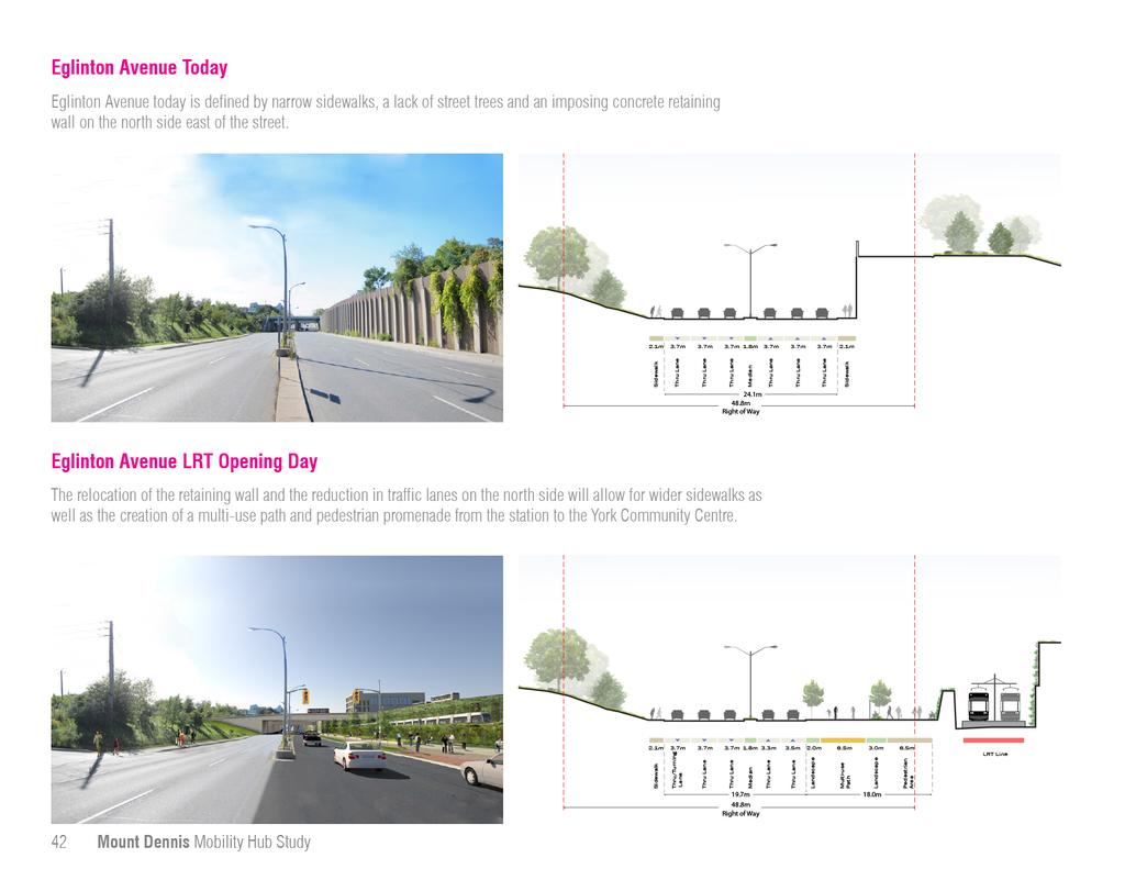
13 Black Creek Drive 3.2 Eglinton Avenue Today today is a wide, car-oriented street with little space or amenity for pedestrians. It is an important east-west connector through the Mount Dennis neighbourhood and the city. West of Keele, Eglinton transitions from a main street to a much wider arterial road that prioritizes the efficient movement of cars. Here, six lanes of traffic and up to two turning lanes transform the street into a fast moving thoroughfare that divides the north and south sides of the street. With the exception of one block west of Weston Road, there are no buildings fronting onto in the study area. Despite the fact that Eglinton connects the Black Creek and Humber Valley systems, there is little to indicate this relationship. Sidewalks are generally narrow and unwelcoming for pedestrians and there is no sidewalk on the north side of Eglinton between Jane and Weston Road. The Eglinton West Trail which runs along the south side of Eglinton does not extend east of Jane Street. East of Weston Road there are few street trees or pedestrian amenities. A large retaining wall along the north side of the street between the rail corridor and Black Creek Drive creates a particularly harsh environment for pedestrians. At the intersection of Weston Road and, in the heart of the community, dedicated and channelized turning lanes create long crossing points for pedestrians. Weston Road Ray Avenue Mount Dennis Mobility Hub Study


14 1 2 The main street condition that exists along much of does not exist west of Keele Street 3 Dedicated turning lanes on top of 6 traffic lanes creates an unfriendly pedestrian environment at Black Creek Drive and Eglinton 4 There is currently no sidewalk on the north side of east of Jane A view of the Kodak Building, retaining wall, and as it passes under Photography Drive Chapter 3 Key Directions 35
15 Tomorrow Major Themes From Public Consultation Over the course of the mobility hub study there were a range of ideas shared with the team regarding the future of. These included: Design the station as a destination for the Community Improve the underpass condition for pedestrians and cyclists Improve the parks on either end of Eglinton Extend the multi-use path between Jane and the Community Centre Improve the streetscape to make the street more enjoyable Minimize traffic impacts What Changes Will Occur? As becomes a transit street, surface movement will shift from being predominantly caroriented to being more supportive of a balance of movement that includes pedestrians and cyclists. Between Pearen Street and Black Creek Drive, a reduction in vehicle lanes will create space for wider sidewalks and streetscape enhancements. Closer to Black Creek Drive, the need to rebuild and relocate the large retaining wall on the north side of Eglinton will create additional opportunities to enhance the image of the street. As the market changes over time, significant redevelopment may be possible at the south west corner of Black Creek Drive and (the Black Creek Triangle). What Do We Want to Achieve? will be an important connection for pedestrians and cyclists between Jane Street and Black Creek Drive, and a key contributing component of the open space and public realm network. Significant streetscape improvements including trees, pedestrian amenities, and a multi-use path, will stitch the two valleys together. At the station, the redesigned retaining wall will help to further enhance the character of the street through the application of special design treatments and create a wide promenade connecting passengers with the new York Community Centre. New development on, including LRT and station infrastructure will contribute to the public realm improvements on the north side of the street through more generous set-backs and planting. 36 Mount Dennis Mobility Hub Study


16 The existing multi-use path that ends at Jane Street should be extended to the new community centre. Generous landscaping will create a true green promenade Lights and public art can transform underpasses Re-naturalized park space at the Keelesdale Road area will enhance the existing park system Streetscape plans must include pedestrian amenities such as seating, lighting, and street trees. A generous, tree-lined path along could help support families traveling between the station and the York Community Centre (flickr: Visit Btown) Chapter 3 Key Directions 37

17 6 Key Strategies For Extend the Multi-Use Path at Jane to the New Community Centre Create an Eglinton Greenway Mount Dennis Station Pearen Park Pearen Street Weston Road Fergi Brown Park Guestville Ave Eglinton Flats 38 Mount Dennis Mobility Hub Study

18 Create a Feature of the Station Wall Renaturalize the Black Creek Valley Coronation Park Kodak Building No 9 Black Creek Drive York Community Centre Keelesdale Park Photography Drive Create a Light and Airy LRT Overpass Provide an Accessible Secondary Entrance Chapter 3 Key Directions 39

19 3.2.1 Create an Eglinton Greenway Long-term artists illustration of the proposed Eglinton Greenway The construction of the station at Mount Dennis will require that the existing retaining wall be reconstructed to the north of its current location. The relocation of the wall and a reduction in lane widths along, can be used to widen sidewalks and introduce enhanced streetscaping, underpass improvements, and cycling amenities. Such changes have the potential to create a green promenade along Eglinton, an Eglinton Greenway connecting the Black Creek Valley in the east with the Eglinton Flats in the west. The transformation of will occur in stages, over time. The completion of the new station in 2020 will result in the improvements to the north side of Eglinton only, including relocation of the retaining wall, wider sidewalks, new investment in streetscaping and pedestrian lighting to enhance safety. A multi-use path between Weston Road and Black Creek Drive will be built connecting the station to the York Community Centre. As lands to the south of are developed, the south side of the street should be enhanced with new streetscaping and active uses facing the street. Actions to Support the Strategy Reduce the number of lanes on to create a 4 lane cross section with more generous boulevard space on both sides of the street Provide setback requirements along the south side of if required to allow a double row of trees Extend improvements west of Weston Road, where space permits 40 Mount Dennis Mobility Hub Study

20 Photography Drive Chapter 3 Key Directions 41

21


22


23


24 The Existing Eglinton Multi-Use Path Across Dedicated Bike Crossings Along the North Side of Eglinton Through Pearen Park The existing multi-use path on Eglinton terminates at Jane Street. From Jane it runs west to Mississauga connecting with the Humber River trail on its way. At Jane Street, a pair of cycling activated crossing points could help cyclists travel to the northeast corner of the intersection. The extended multi-use path could run along the north side of the Eglinton right of way on the north side of the trees. The path could run along the southern edge of the baseball diamond between a colonnade of trees to connect with Pearen Street due to insufficient room for a multiuse path on Eglinton in this section Along a Reclaimed Merging Lane The Station Along the Eglinton Promenade Along the North Side of Eglinton Between Pearen Street and the station, the multi-use path could run along an area that is currently being used as a merging lane but is no longer needed. The Weston Road Station Entrance will contain enhanced bike facilities including secure indoor bike parking for cyclists. East of the rail corridor a secondary entrance will contain outdoor sheltered bike parking. From the Secondary Entrance the path could run alongside the proposed pedestrian promenade to the community centre and a future trail on Black Creek. East of Black Creek Drive, either a multiuse path or bike lanes could be provided to connect to the broader cycling network planned by the City. Chapter 3 Key Directions 45


 and a glazed structure over the tracks (2), none has the")


25 3.2.3 Create a Feature of The Station Wall In order to construct the LRT beneath the rail corridor, the existing retaining wall along the north side of must be removed. A new retaining wall will need to be rebuilt north of the LRT trackway, including a protective structure between the LRT trackway and the new sidewalk on Eglinton. This creates an opportunity to provide more generous pedestrian environment and create a feature of the new retaining wall that can enhance the image of. While the Mobility Hub Study examined multiple strategies including the creation of an art wall (1) and a glazed structure over the tracks (2), none has the potential to assist in transforming the image of Eglinton Avenue more than the development of a planted retaining wall system (3). 1 Art Wall 2 Structure The creation of a planted retaining wall along the north side of Eglinton would help to extend the green characteristic of the Black Creek Valley west along and create the unique experience for transit riders of exiting the portal west of Keele and traveling over Black Creek Drive through a lush landscape into the Mount Dennis Station. There are a number of systems for the creation of a planted retaining wall including the use of stacked concrete bins filled with plants and soil, wire and cage systems to enable plants to grow up the wall, and terraces that allow plants to cascade down the sides of the retaining wall. Consideration should be given to the long term maintenance of the wall with preference given to systems that employ low-maintenance materials which bloom early and last late into the fall, and remain attractive in the winter. Actions to Support the Strategy Explore the integration of a planted retaining wall along the north side of Eglinton 46 Mount Dennis Mobility Hub Study 3 Planted (Mayr Ludescher Partner) (SSL Innovative Construction Products)


26 3.2.4 Provide an Accessible Secondary Entrance While the primary entrance to Mount Dennis Station will be located at the corner of Weston Road and, there is an identified need for a secondary entrance at grade on to serve new development on the Black Creek Triangle, the new community centre, and valley parks at Black Creek Drive. Kodak Building No 9 Secondary Entrance Building Photography Drive As the primary entrance between the station and York Community Centre, the entrance should be designed to be fully accessible and set back sufficiently to preserve adequate space for the multi-use path and street plantings of the Eglinton Greenway. An opportunity also exists to help animate the Photography Drive underpass and enhance the environment of the station by creating a highly glazed structure that will bring light into the station during the day and act as a lantern along the street at night. A secondary station entrance structure fronting on to Eglinton and spanning under the new Photography Drive bridge An interesting and welcoming secondary entrance building that creates a unique feature along the street Glazing and passenger amenities such as real-time train information create an inviting environment in this fully-accessible secondary entrance Chapter 3 Key Directions 47


27 3.2.5 Re-naturalize the Black Creek Valley Potential Storm Water Management Pond The closure of Keelesdale Drive to accommodate the LRT overpass provides an opportunity to re-naturalize this western section of the Black Creek Valley area. Along with natural vegetation and storm water management ponds, the design of the area should include paths that connect up to the Black Creek Business Park and fully integrate the site into the larger valley park system. Pedestrian Path Black Creek Drive Coronation Park Keelesdale Park Actions to Support the Strategy York Community A re-naturalized Keelesdale Road area would extend the existing park system across Black Creek Centre Road and engage with the station area. If all stormwater cannot be treated on site, explore the potential to store stormwater from the Maintenance and Storage Facility in a naturalized Storm Water Management Pond on the existing site of Keelesdale Drive Explore the potential of designating the Black Creek Valley a Community Action Site and working with the TRCA to re-naturalize the area over time The Keelesdale Road area today is heavily vegetated A naturalized storm water management facility in the valley has the potential to become a unique destination for walking within the valley Trails and paths could be provided to connect the Black Creek Drive and intersection with the Black Creek Business Park 48 Mount Dennis Mobility Hub Study


28 3.2.6 Create a Light and Airy LRT Guideway The elevated guideway over Black Creek Drive will be a significant structure that is highly visible for people passing through the area or making use of the valley lands and new community centre. The design of the structure should strive to reduce its actual and perceived size in order to minimize the impact of the guideway on its surroundings including the future pedestrian and cycling path adjacent to it. While minimizing the appearance of the guideway through its design and engineering will be important to achieving a light and airy structure, an opportunity also exists to celebrate the structure and the dynamic image of the LRT passing overhead through the use of public art. This could take the form of patterns applied to the structure or through the use of lighting which could be manipulated to change over time or when an LRT is passing by. Actions to Support the Strategy Explore the use of a more streamlined structure, such as a single box structure A transit overpass in Vancouver accommodates a multi-use path beneath it (flickr: buzzerblog) Maximize the transparency of railings atop the structure so that it looks slimmer Explore guideway treatments that reflect the aesthetic of the station Work with the local community to identify a public art strategy for the structure New LRT Guideway Coronation Park York Community Centre Keelesdale Park Black Creek Drive The LRT overpass with fly-over Black Creek Drive, through two parks, and past a new Community Centre. Chapter 3 Key Directions 49

29 3.3 Weston Road Weston Road Today Weston Road is the historic main street for the Mount Dennis Community and characterized by a mix of primarily two-storey mixed use main street and residential development. While Weston Road was once a more significant commercial destination for the community, the vitality of the street has suffered substantially over the last 20 years, a victim of declining local employment, reduced incomes in comparison to other areas of the city and competing retail uses located to the south and north of the station area. Today many of the shops along the street are vacant and some former retail spaces have been converted to residential uses. Where larger parcels of land have been assembled, main street buildings are being demolished and replaced by low-rise townhouse developments facing the street. This has led to a reduction in street life and eyes on the street which contributes to the sense of a lack of safety for area residents. In contrast to many of the city s retail main streets, there are currently no street trees along Weston Road. This is a result of overly generous lane widths which leave little room for planting along sidewalk and boulevard. Dedicated turning lanes at create long crossing distances for pedestrians. In recent years, parts of the street have seen investment in new street furnishings including smaller planter boxes, pedestrian lighting and hanging baskets. Black Creek Drive Ray Avenue Weston Road 50 Mount Dennis Mobility Hub Study


30 1 2 4 In places, new townhouse development has replaced mixed-use buildings along Weston Road 3 Recently implemented streetscape improvements The Mount Dennis Community Centre 5 The Weston main street today still has the traditional retail form The Weston and Eglinton Intersection is a wide crossing for pedestrians Chapter 3 Key Directions 51
31 Weston Road Tomorrow Major Themes From Public Consultation Over the course of the mobility hub study there were a range of ideas shared with the team regarding the future of Weston Road. These included: Preserve Weston s main street function Enhance the public realm to make the street more welcoming Design the station park as a destination Enhance pedestrian crossings to make it safer to cross the road Incorporate lighting into the station to improve safety What Changes Will Occur? The introduction of enhanced transit to Mount Dennis is not expected to have an immediate impact on Weston Road. Instead, a gradual improvement to the residential market driven by buyers looking for affordable housing with good access to transit and amenities will lead to improvements in the viability and quality of Weston Road retail over time. As the market changes, the evolution of Weston Road could be supported by a range of initiatives including improvements to the look and character of the street and an increase in employment and residential densities that can help to improve retail demand. Success over the long-term will be dependent on establishing an enjoyable pedestrian environment with locally based shops that provide a unique retail offer. What Do We Want to Achieve? Weston Road will be preserved as the neighbourhood "main street," with a vibrant retail core enhanced by consistent streetscaping, new green space and, in the longer term, wider sidewalks with trees. While much of the street should remain low-rise, welldesigned mid-rise buildings on larger parcels will help add more people and uses. Closer to the station a new park will become a focal point for the neighbourhood, animated by new development that also provides amenity for transit riders. 52 Mount Dennis Mobility Hub Study


32 Safe pedestrian crossings with narrow turning radii New development that increases pedestrian activity and helps to support retail Improved streetscape with street trees that can help to make the street more inviting Preserved main street buildings that can support new retail uses over time Chapter 3 Key Directions 53

33 7 Key Strategies For Weston Road Anchor the Station with New Development Encourage Mid-Rise Development along Weston Road Create a Series of Small Open Spaces Bartonville Avenue Ray Avenue Weston Road Somerville Avenue Pearen Park Create a New Mount Dennis Park 54 Mount Dennis Mobility Hub Study

34 Coronation Park Keelesdale Park Preserve for New Retail Uses on Weston Road Black Creek Drive Transform the Southern Entrance to the Community Barr Avenue Weston Road Jasper Avenue Enhance Streetscapes and Widen Sidewalks Lambton Avenue Dennis Avenue Community School Chapter 3 Key Directions 55

35 3.3.1 Anchor the Station Entrance With New Development On opening day, a new station entrance will be provided on the north side of just west of the GO Rail corridor, with a walkway providing access to the corner of Weston Rd and. Because the Scotia Bank building at 1151 Weston Road may be retained in the near term, it is important for the new station entrance and walkway to be designed to maximize visibility and access from the Mount Dennis neighbourhood to the west. Over time, it is recommended that 1151 Weston Road and adjacent properties support more intense land uses given their proximity to the station. This will help to support the Mobility Hub Study objectives, create an opportunity to add more people and uses to the station area and enable the development of a new park (see section 3.3.2) at the intersection of Weston Road and. Actions to Support the Strategy Ensure the design of the station entrance helps to reinforce sightlines to and from Weston Road Tree plantings, signage and pedestrian lighting should be organized to reinforce the connection to and from Weston Road and designed to compliment the design language of the station so that the entrance is recognizable from the street Establish a site and area specific policy to require: a comprehensive assembly, development concept, and zoning implementation for the redevelopment of the entire station block that incorporates the design and placement of the station building, the possible integration of the Scotia Bank building and a new public park at Weston Road in whole or in part Design the station building to anticipate and support the redevelopment of the lands through the careful siting of station servicing, the station entrance and mechanical vent shafts Ensure taller buildings are designed to transition in scale down to low-rise neighbourhoods through the use of angular planes and podiums 56 Mount Dennis Mobility Hub Study Anchor the Station Entrance With New Development Hollis Street Weston Road Kodak Building No 9 Primary Entrance Opening Day Connecting to the Station Entrance On opening day the new station will be constructed to the rear of the Scotia Bank along. New streetscaping should seek to enhance station visibility and access by establishing a generous pedestrian promenade between the station entrance and Weston Road. This should be supported by streetscape elements such as pedestrian oriented lighting, seating and tree plantings which are coordinated to reflect the architectural language of the station and its surrounding open spaces.

36 Kodak Building No 9 Primary Entrance Hollis Street Scenario A Small Mixed-Use Development to Face the Park Weston Road Over the long term, if the Scotia Bank property is amalgamated with the lands required for the construction of the station entrance it would be large enough to accommodate a small infill project of between three and four stories in height and preserve for the creation of a new public park at the intersection of Weston Road and (pg 59). Redevelopment at this scale should help to enhance visibility and access to the station entrance and provide new active uses facing the Park without impacting upon the existing housing next to the station. Chapter 3 Key Directions 57

37 Kodak Building No 9 Mount Dennis Station Hollis Street Scenario B Integrating Taller Buildings to Landmark the Station Entrance Weston Road Alternatively, if all the properties along the south side of Hollis Street are acquired by a third party and consolidated with the station lands through a partnership with Metrolinx, the site would be large enough to contain a more significant building with a podium and high-rise component. The additional density would likely benefit retail in the surrounding area and help to increase safety through additional eyes on the street. This type of development would create an opportunity to be integrated with the station entrance. Development at this scale should help to enhance visibility and access to the station entrance and transition in scale down to Hollis Street to re-complete the street. 58 Mount Dennis Mobility Hub Study


38 3.3.2 Create a New Mount Dennis Park/Public Square Should the site of the Scotia Bank be redeveloped, an opportunity exists to develop a new larger public park at the entrance to the station. A green space fronted by active uses The new open space should be designed to function as the forecourt to the station entrance, connecting passengers between the station and Weston Road. As such, the treatment of the space and its furnishings should be complimentary to the design of the station entrance and include elements such as pedestrian oriented lighting, seating and waste receptacles. The design should include both hard and soft landscaping but overall should seek to create a green space with generous plantings and clusters of trees that will help to reinforce the image of an Eglinton greenway and provide a pleasant place to linger along Weston Road. Weston Road Hollis Street A new park at Weston Road and Landscaping in front of parking Actions to Support the Strategy Should the lands surrounding the station be redeveloped, work with the land owners to establish a new public open space If a public open space is not achievable work with the owners to develop a publicly accessible open space designed to read and act as a neighbourhood open space Work with the local community and BIA to identify opportunities for the integration of public art Clusters of planting and pathways connecting to the station Chapter 3 Key Directions 59


39 3.3.3 Preserve for New Retail Uses on Weston Road Their is strong support amongst members of the Mount Dennis community to rejuvenate Weston Road as the local retail focus of the community. Ensuring that buildings preserve for retail uses along the street will be a key strategy to enable the street to restore its retail function. This will require that the current trend of permitting townhouses or conversion of retail spaces to permanent residential uses is stopped in areas where the traditional main street fabric is still intact. A poor retail market in the short-term can be mitigated through alternative strategies such as encouraging the occupation of retail spaces with galleries or permitting live/work arrangements that preserve for the return of full retail uses over time. Similar initiatives in Newcastle Australia have proven successful with this approach. A Renew Newcastle poster advertising the pop-up store and gallery spaces created in vacant storefronts. A similar strategy could be engaged in Mount Dennis. A temporary gallery in a vacant retail space A pop-up store The preservation of retail buildings in the Junction has enabled the street to be revitalized as the market improved Actions to Support the Strategy Develop a retail retention zone with supportive zoning that requires the provision of retail space at street level Where retail is unfeasible in the short term, ensure buildings are designed to support conversion Retail Retention Zone Pearen Street Weston Road Mixed-Use Infill Mount Dennis Station Guestville Avenue Ensure that buildings preserve for retail uses in core areas (highlighted in red) 60 Mount Dennis Mobility Hub Study


40 3.3.4 Encourage Mid-Rise Development along Weston Road Weston Road Weston Road is designated by Toronto s Official Plan as an Avenue from Jane to just south of Eglinton Avenue. This designation encourages mid-rise buildings of 5-6 storeys that are designed to integrate with adjacent houses. Extending a similar supportive policy framework further south along Weston Road would help to make it easier to develop mid-rise buildings along Weston Road. This would help to increase activity over time, support more main street retail and enhance safety. Actions to Support the Strategy Mid-rise Infill Building Lambton Avenue Ensuring that there is a policy framework in place to support mid-rise development north and south along Weston Road would help to make it easier for larger redevelopment sites to develop with higher densities Consider reviewing zoning to support the existing site and area specific policy that permits 5 story buildings, south to Lambton Avenue Apply the mid-rise guidelines to new development to ensure that they integrate with adjacent low-rise areas Setback requirements stipulated by the Avenue designation would generally limit new mid-rise development to between 5 and 6 storeys along the street Chapter 3 Key Directions 61
41 3.3.5 Enhance Streetscapes and Widen Sidewalks Weston Road Today Weston Road today is defined by narrow sidewalks, inconsistent application of streetscape enhancements and areas of surface parking that detract from the character of the street. Weston Road is currently characterized by narrow sidewalk widths and a streetscape treatment that varies between the north and south side of Eglinton Avenue. In some places, areas of surface parking create gaps and detract from the character of the street. In the short-term, an opportunity exists to enhance the image of the street with a more consistent application of streetscape elements and landscaping that can buffer areas of off-street surface parking. Over the longer term an opportunity exists to gain additional sidewalk space and enable the planting of street trees through the application of narrower street widths. Actions to Support the Strategy Work with the Mount Dennis BIA to support more comprehensive streetscape improvements between Lambton and Bartonville Avenue Existing Low-rise Building Existing Setback Short Term Improvements 2.65m Sidewalk 4.10m 3.50m 3.50m 4.15m 3.40m Vehicle Lane & Off-Peak Parking Vehicle Lane Vehicle Lane 15.30m Vehicle Lane & Off-Peak Parking Sidewalk Existing Surface Parking In the short-term the street can be improved by consistently applying streetscape enhancements throughout the main street area and landscaping to shield areas of surface parking. Target edges of existing surface parking lots for new planting and street trees that can help to minimize their impact on the street Review opportunities for reduced lane widths and initiate a program of street tree planting when Weston Road is reconstructed over the longer term or incrementally as opportunities arise through new development Existing Low-rise Building Existing Setback 2.65m 1.90m Sidewalk 0.50m Planting Box 0.25m Setback 4.10m 3.50m 3.50m 4.15m 3.40m 2.00m Vehicle Lane & Off-Peak Parking Vehicle Lane Vehicle Lane 15.30m Vehicle Lane & Off-Peak Parking 0.40m Setback 0.50m Planting Box 2.50m Sidewalk Private Landscape Setback Existing Surface Parking 62 Mount Dennis Mobility Hub Study 21.30m Right of Way


42 Weston Road Over The Long Term Shrinking lane widths to provide enough sidewalk space for street trees and amenities would help to transform the character of the street over the longer term. Existing Low-rise Building Existing Setback 1.62m Sidewalk 2.23m Apron & Landscape Zone 3.50m Vehicle Lane & Off-Peak Parking 3.30m 3.30m 3.50m Vehicle Lane Vehicle Lane 13.60m Vehicle Lane & Off-Peak Parking 2.23m Apron & Landscape Zone 1.62m Sidewalk Future Development Note: Subject to review by the City. All plans need to balance the needs of all modes including pedestrians, cyclists, transit and goods movement. If lane widths are reduced, incorporating street trees in grates can help to make the most of limited sidewalk space The planting of trees along the narrow Queen Street east strip helps to create a more inviting street for pedestrians Chapter 3 Key Directions 63


43 3.3.6 Transform the Southern Entrance to the Community In contrast to the Weston Road main street to the north, the small employment area at the northeast corner of Weston Road and Black Creek Drive accommodates a mix of manufacturing/retail and service uses that serve a much broader area. Over time, it is likely that the north half of the employment area at Weston Road and Black Creek Drive will transition from manufacturing and service uses to residential uses. Future development should face the street and provide a road network that buffers residential uses, supports employment intensification south of Jasper and enables lands between Bushey and Lambton to redevelop as residential over time. Redevelopment and intensification of the employment lands should face Weston Road and accommodate parking at the side or rear of the building. Actions to Support the Strategy Redevelopment of the employment areas should face the street and accommodate parking to the rear The north half of the triangle has the potential to transition to residential uses over time Investigate with land owners the development of a comprehensive redevelopment strategy for the lands east of Weston Road between Lambton and Black Creek. If a strategy is achieved, use the outcomes to inform zoning and OP amendments and assist in the review of development applications Brownville Avenue Residential Infill Consolidated Access Commercial Redevelopment Black Creek Drive Weston Road Redevelopment of sites in the triangle should establish a street and/or driveway network that supports the intensification of adjacent residential and employment areas over time 64 Mount Dennis Mobility Hub Study


44 3.3.7 Create a Series of Small Open Spaces While there is not much room on Weston Road for new green space or patios, there are a number of small underutilized spaces located at the side or corner of buildings where local streets meet Weston Road. Weston Road An opportunity exists to transform these side lots over time into small community gathering areas, cafe space or gardens. These new spaces could help to compliment local businesses by providing opportunities for spill-out uses or could be cared for and maintained by members of the community as a component of a neighbourhood greening initiative. Actions to Support the Strategy Oxford Street Denarda Street Work with the Mount Dennis BIA, residents and local businesses to identify, articulate and implement opportunities to transform underutilized side spaces over time Small underutilized spaces where side streets meet Weston Road have the potential to be transformed into new community spaces The side spaces could be greened as part of a community gardening/greening initiative Businesses should explore how side spaces could be used to support their activities with patios or business spill-out space (Flickr: Mad Mou) Chapter 3 Key Directions 65
Prepared for Metrolinx by:
 Mount Dennis Mobility Hub Study August 2013 Prepared for Metrolinx by: Acknowledgements Community Liaison Group Patrick Saavedra Barbara Stone Marabelle McTavish Barbara Spyropoulos Robyn Hoogendam Robert
Clairtrell Area Context Plan
 Clairtrell Area Context Plan March 2005 Urban Development Services City Planning Contents 1. Introduction... 4 2. Development Structure... 6 2.1 Streets... 7 2.1.1 Sheppard Avenue and Bayview Avenue...
Mount Dennis Mobility Hub Study Public Meeting December 12 th, :30pm 9:30pm York Memorial Collegiate, Cafeteria 2690 Eglinton Avenue West
 Mount Dennis Mobility Hub Study Public Meeting December 12 th, 2012 6:30pm 9:30pm York Memorial Collegiate, Cafeteria 2690 Eglinton Avenue West MEETING SUMMARY On December 12 th, 2012, over 89 people participated
Figure 3-1: Public Realm Plan
 3 Public Realm Figure 3-1: Public Realm Plan 3.1 Public Realm Concept The public realm concept for the Little Mountain site integrates a clear and accessible movement network with public spaces for social
The Master Plan Framework
 The Master Plan Framework The East Harbour Master Plan advances the development of 60 acres of former industrial lands east of the Don River. The Master Plan outlines a vision for a vibrant, transit-oriented
ELMVALE ACRES SHOPPING CENTRE MASTER PLAN
 ELMVALE ACRES SHOPPING CENTRE MASTER PLAN Contents 1.0 INTRODUCTION... 2 2.0 LOCATION... 2 3.0 EXISTING CONTEXT... 2 4.0 VISION & GUIDING PRINCIPLES... 2 5.0 LAND USE AND BUILT FORM... 4 5.1 St. Laurent
QUEEN-RIVER SECONDARY PLAN
 34 QUEEN-RIVER SECONDARY PLAN 34. QUEEN RIVER SECONDARY PLAN 1. INTRODUCTION The Queen-River area is approximately 6.4 hectares and is located at the eastern edge of the Downtown as shown on Map 34-1.
Urban Design Manual PLANNING AROUND RAPID TRANSIT STATIONS (PARTS) Introduction. Station Study Areas
 Introduction. Station Study Areas") 111111 PLANNING AROUND RAPID TRANSIT STATIONS (PARTS) Introduction The ION rapid transit system will link Waterloo, Kitchener and Cambridge through a central transit corridor (CTC). There are a number
111111 PLANNING AROUND RAPID TRANSIT STATIONS (PARTS) Introduction The ION rapid transit system will link Waterloo, Kitchener and Cambridge through a central transit corridor (CTC). There are a number
ROBBINSDALE LRT STATION CDI DEVELOPMENT GUIDELINES
 August 2018 OVERVIEW The City of Robbinsdale has a prime-opportunity site in the middle of the 13 mile stretch of the Bottineau LRT corridor / Blue Line extension. Robbinsdale offers a prominent, vital,
URBAN DESIGN BRIEF URBAN DESIGN BRIEF 721 FRANKLIN BLVD, CAMBRIDGE August 2018
 URBAN DESIGN BRIEF URBAN DESIGN BRIEF 721 FRANKLIN BLVD, CAMBRIDGE August 2018 DESIGN BRIEF CONTENTS PART A 1.0 INTRODUCTION 2.0 DESCRIPTION & ANALYSIS OF SITE CONTEXT 3.0 DESIGN CONSTRAINTS AND OPPORTUNITIES
WELCOME and introduction
 1 WELCOME and introduction Mobility Hub Locations within Burlington STUDY OVERVIEW STUDY OBJECTIVES The City of Burlington is developing four Area Specific Plans, one for each of Burlington s Mobility
DRAFT DRAFT DRAFT DRAFT
 # 19 EXPAND GREEN AND OPEN SPACES AND COMMUNITY FACILITIES IN TANDEM WITH NEW DEVELOPMENT The role of Eglinton will change in the coming years, along with the intensity of activity and land uses. As more
Bloor Street East Potential Ravine Portal Overlook and Access Passage to the Rosedale Valley and Don River Valley Ravine, Toronto, Canada
 TRANSFORMATIVE IDEA 2. GREAT STREETS Bloor Street Christie Pits Park Bloor St Spadina Ave Bathurst St Shaw St 1 Recognize the significant public realm improvements along Bloor Street and extend and enhance
The West Vaughan Employment Area Secondary Plan Policies
 Part 2: The West Vaughan Employment Area Secondary Plan Policies 2.1 General Policies It is the policy of Council: 2.1.1. That the West Vaughan Employment Area (the WVEA), identified on Schedule 1, will
Town Center (part of the Comprehensive Plan)
") Town Center (part of the Comprehensive Plan) Mercer Island Town Center Looking North (2014) In 1994, a year-long process culminated in a set of design guidelines and code requirements for the Town Center
Town Center (part of the Comprehensive Plan) Mercer Island Town Center Looking North (2014) In 1994, a year-long process culminated in a set of design guidelines and code requirements for the Town Center
CHAPTER 5: GUIDING PRINCIPLES
 CHAPTER 5: GUIDING PRINCIPLES The following 10 principles were developed based on public consultation, planning policy and the background analysis conducted during Phase 1. The Guiding Principles significantly
5.1 Site Plan Guidelines
 5. Community Core Guidelines Development of the Community Core will take place by plan of subdivision and site plan approval. It will occur in a phased manner that will reflect the timing of residential
WEST LOOP DESIGN GUIDELINES CHECKLIST
 WEST LOOP DESIGN GUIDELINES CHECKLIST Section 1.0 General Strategies 1.1 DESIGN EXCELLENCE: ENCOURAGE HIGH QUALITY AND INNOVATIVE DESIGN OF NEW BUILDINGS WITHIN THE WEST LOOP WITHOUT BEING PRESCRIPTIVE
38 Queen s University Campus Master Plan Part 1
 38 Queen s University Campus Master Plan Part 1 46 The Campus at the City Scale Chapter 4 The Campus at the City Scale 39 Queen s is an urban University centrally located in Kingston. Decisions made by
burlington mobility hubs study Downtown Burlington Mobility Hub
 burlington mobility hubs study Downtown Burlington Mobility Hub Draft Precinct Plan Workbook PIC #3, September 7, 2017 downtown mobility hub objectives City staff and their consultants are proposing an
UTSC SECONDARY PLAN COMMUNITY OPEN HOUSE
 WELCOME TO THE UTSC SECONDARY PLAN COMMUNITY OPEN HOUSE 1 Welcome to the first Community Open House for the UTSC Secondary Plan. Hosted by the University of Toronto Scarborough (UTSC), the following panels
Robbinsdale LRT Station. CDI Development Guidelines. August Overview
 Robbinsdale LRT Station August 2018 Overview The City of Robbinsdale may have the coolest opportunity site along the 13 mile stretch of the Bottineau LRT corridor / Blue Line extension. Located a block
THE CITY OF VAUGHAN BY-LAW BY-LAW NUMBER A By-law to adopt Amendment Number 1 to the Official Plan of the Vaughan Planning Area.
 THE CITY OF VAUGHAN BY-LAW BY-LAW NUMBER 015-2014 A By-law to adopt Amendment Number 1 to the Official Plan of the Vaughan Planning Area. NOW THEREFORE the Council of the Corporation of the City of Vaughan
DRAFT. 10% Common Open Space
 % OF CHARLOTTE IS CATEGORIZED AS A. LAND USES : Placeholder map displaying location of Place Type GOALS: Accommodate XX% of future growth. Provide a concentration of primarily commercial and civic activity
This Review Is Divided Into Two Phases:
 Semiahmoo Town Centre Review The purpose of this review: To review the Semiahmoo Town Centre Concept Plan, originally approved in 1993, to ensure that this centre will continue to serve the needs of South
The University District envisions, in its neighborhood
 Envisioning the University District Link Light Rail in Seattle s neighborhoods CIY OF SEALE CONCEP-LEVEL SAION AREA PLANNING RECOMMENDAION RESOLUION # 30165 EXHIBI L Vision 08.2000 he University District
DRAFT Northeast Quadrant of Kipling Avenue and Highway 7 DRAFT AUGUST 29, Goals Land Use. The goals of this Plan are to:
 AUGUST 29, 2017 12.15 Northeast Quadrant of Kipling Avenue and Highway 7 12.15.1 Goals 12.15.2 Land Use The goals of this Plan are to: 12.15.2.1 General Provisions: a) Ensure the development of a compact
Don Mills Crossing Study and Celestica Lands Development Application Community Meeting, Open House, and Breakout Discussions
 Consultation Summary Don Mills Crossing Study and Celestica Lands Development Application Community Meeting, Open House, and Breakout Discussions This report is not intended to provide a verbatim transcript
DRAFT. October Wheaton. Design Guidelines
 October 2011 DRAFT Wheaton Design Guidelines 2 Draft - Design Guidelines - Wheaton Sector Plan Contents 04 Section 1: Introduction 06 Section 2: Context 08 Section 3: Design Guidelines 09 Goal 1: Create
Policies and Code Intent Sections Related to Town Center
 Policies and Code Intent Sections Related to Town Center The Town Center Vision is scattered throughout the Comprehensive Plan, development code and the 1994 Town Center Plan. What follows are sections
Complete Neighbourhood Guidelines Review Tool
 Complete Neighbourhood Guidelines Review Tool Prepared By: City of Regina Planning Department October 2014 Page 1 of 14 Community Development Review Checklist for Secondary Plans and Concept Plans The
THE CIVIC DISTRICT DEVELOPMENT OPPORTUNITIES
 1 THE CIVIC DISTRICT DEVELOPMENT OPPORTUNITIES The Civic District is the physical and emotional heart of the downtown. It is also a major gateway into the central core, establishing the image and identity
Prepared for Metrolinx by:
 Prepared for Metrolinx by: Acknowledgements Metrolinx Mobility Hub Project Team Ian Griffiths Lisa Salsberg Daniel Haufschild Leslie Woo Joshua Engel-Yan Marcus Bowman Consulting Firms Urban Strategies
4- PA - LD - LIVELY DOWNTOWN. LD - Background
 4- PA - LD - LIVELY DOWNTOWN LD - Background The downtown has been the service centre for the community since the city s inception and the area continues to supply people with their personal services,
PILLAR FOUR INTEGRATE LAND USE & TRANSPORTATION
 PILLAR FOUR INTEGRATE LAND USE & TRANSPORTATION 8 Scarborough Centre on the Move Transportation Master Plan 123 8 Transportation Pillar Four Integrate Land Use & The fourth pillar focuses on the relationship
ARLINGTON COUNTY, VIRGINIA
 ARLINGTON COUNTY, VIRGINIA County Board Agenda Item Meeting October 15, 2005 DATE: September 28, 2005 SUBJECT: Request to Advertise the adoption of the 2005 Clarendon Sector Plan C. M. RECOMMENDATION:
Welcome. Community Consultation Meeting November 28, Review and discuss the Bathurst Quay Neighbourhood Plan Framework
 Welcome Community Consultation Meeting November 28, 2016 Why Are We Here Today? Review and discuss the Bathurst Quay Neighbourhood Plan Framework Review and discuss an Action Plan for Implementation Next
Table of Contents. Elm Avenue Improvement Plan City of Waco, Texas. Introduction 1. Existing Context 1 Figure 1 2.
 Table of Contents Introduction 1 Existing Context 1 Figure 1 2 Plan Guidelines 3 Future Urban Form 4 The West-End 4 Main Street 6 The East-End 7 Figure 2 9 Public Improvement Recommendations 7 General
Workshop 3. City of Burlington Waterfront Hotel Planning Study. September 14, The Planning Partnership
 Workshop 3 City of Burlington Waterfront Hotel Planning Study September 14, 2017 The Planning Partnership The Waterfront Hotel Planning Study 01 The Brant & Lakeshore Planning Study will establish a Strategic
Ivywild On The Creek PRELIMINARY CREEK DISTRICT MASTER PLAN
 Ivywild On The Creek PRELIMINARY CREEK DISTRICT MASTER PLAN Introduction: Rejuvenating an extraordinary Creekside neighborhood THE CREEKSIDE DISTRICT The Ivywild On The Creek Neighborhood District Master
Silverdale Regional Center
 Silverdale Regional Center Vision for Silverdale Regional Center The Silverdale Regional Center Plan (Plan) will guide the evolution of the Silverdale Regional Center from a collection of strip malls and
New-Cast Mixed-use Development Proposal King Street West, Newcastle, Ontario
 URBAN DESIGN BRIEF New-Cast Mixed-use Development Proposal King Street West, Newcastle, Ontario TABLE OF CONTENTS: 1.0 Executive Summary 2.0 Creating Vibrant and Sustainable Urban Places: Excerpts from
City of Farmington. Downtown Plan. Amendment to the 1998 Master Plan Adopted October 11, 2004
 City of Farmington Amendment to the 1998 Master Plan Adopted October 11, 2004 Introduction Planning Background 1 Scope and Components of the Plan Amendment 2 Concept Introduction 3 Plan Concepts 3 Conceptual
Metrogate Agincourt Redevelopment
 Toronto Urban Design Guidelines Metrogate Agincourt Redevelopment City Planning Urban Design September 2008 METROGATE AGINCOURT REDEVELOPMENT TABLE OF CONTENTS 1.0 INTRODUCTION......................................................
PROPOSED REDEVELOPMENT OF THE GLEN ABBEY GOLF CLUB. STREETSCAPE DESIGN STUDY (excerpt from the Urban Design Brief) TOWN OF OAKVILLE.
 TOWN OF OAKVILLE.") PROPOSED REDEVELOPMENT OF THE GLEN ABBEY GOLF CLUB STREETSCAPE DESIGN STUDY (excerpt from the Urban Design Brief) TOWN OF OAKVILLE OCTOBER, 2016 for 2.4.2 STREETS Streets are the single largest component
PROPOSED REDEVELOPMENT OF THE GLEN ABBEY GOLF CLUB STREETSCAPE DESIGN STUDY (excerpt from the Urban Design Brief) TOWN OF OAKVILLE OCTOBER, 2016 for 2.4.2 STREETS Streets are the single largest component
Urban Design Manual 2.0 DRIVE-THROUGH FACILITIES. Background. Urban Design Challenges
 222221 2.0 DRIVE-THROUGH FACILITIES Background In recent years, drive-through facilities have grown significantly in popularity with drive-through restaurants, in particular, being established on numerous
DOWNTOWN GEORGETOWN PLANNING STUDY
 DOWNTOWN GEORGETOWN PLANNING STUDY Community Workshop #3 Thursday, May 4, 08 The Planning Partnership OVERVIEW OF STUDY, PROCESS & MILESTONES We are here PURPOSE OF THE STUDY To develop a clear vision
Uptown Rideau Street Secondary Plan [Amendment #166, January 12, 2016]
![Uptown Rideau Street Secondary Plan [Amendment #166, January 12, 2016]](/thumbs/76/73760497.jpg "Uptown Rideau Street Secondary Plan [Amendment #166, January 12, 2016]") [Amendment #166, January 12, 2016] The policies of this Secondary Plan are in effect, save and except for the property at 560 Rideau Street, for which there remains a site specific appeal to this Secondary
[Amendment #166, January 12, 2016] The policies of this Secondary Plan are in effect, save and except for the property at 560 Rideau Street, for which there remains a site specific appeal to this Secondary
The Cambie Corridor 2015 Fall workshop series. What we heard WORKSHOP OUTLINE
 The Cambie Corridor 2015 Fall workshop series W 16 AVE Area 5 CAMBIE CORRIDOR Phase 3 What we heard ovember 21, 2015, 9am-noon, 1:30-4:30pm Peretz Centre 89 Participants* WORKSHOP OUTLIE Introductions
appendix and street interface guidelines
 appendix five: building and street interface guidelines appendix 5 building and street interface guidelines BOULEVARDS Boulevards are generally characterized by higher levels of traffic movement at higher
GOLDEN MILE SECONDARY PLAN. Community Consultation Meeting #3 June 26, 2018
 GOLDEN MILE SECONDARY PLAN Community Consultation Meeting #3 June 26, 2018 Meeting Overview 1. Introduction 2. Principles + Vision 3. Street + Block Alternatives 4. Parks + Open Space Alternatives 5. Land
John M. Fleming Managing Director, Planning and City Planner. Old East Village Dundas Street Corridor Secondary Plan Draft Terms of Reference
 Report to Planning and Environment Committee To: From: Subject: Chair and Members Planning & Environment Committee John M. Fleming Managing Director, Planning and City Planner Old East Village Dundas Street
Public Consultation Summary: Lakeview Place Making Workshop January 30, 2008.
 Page 1 of 11 Public Consultation Summary: Lakeview Place Making Workshop January 30, 2008. 1.0 Introduction: On January 30, 2008 the City of Mississauga, in conjunction with the consulting team of Brook
401/Keele Provincial Campus Ontario Realty Corp.
 1.0 INTRODUCTION 1.1 Site Location and Description The study area consists of approximately 74 acres (30 ha) located in the Keele Street and Wilson Avenue area. It is bounded by Wilson Avenue to the north,
GUIDELINES WESTON LOCATION: URBAN DESIGN GUIDELINES
 Development in the Weston area will be consistent with the following urban design guidelines. The guidelines correspond to Site and Area Specific Policies 45, 46, 47, 48, 49, 51, 52 and 232 in Chapter
HIGHLAND VILLAGE GREEN URBAN DESIGN PRINCIPLES/GUIDELINES
 URBAN DESIGN GUIDING PRINCIPLES/GUIDELINES CONTEXT/CHARACTER The City of Calgary s Municipal Development Plan (MDP), Transit-Oriented Development (TOD) Policy Guidelines and Main Street/Corridor policy
Agenda. 7 Wright Crescent Urban Design Study. Public Meeting and Urban Design Workshop. 1 INTRODUCTION AND BACKGROUND (City of Kingston)
") Urban Design Study Public Meeting and Urban Design Workshop October 02, 2013 Agenda 1 INTRODUCTION AND BACKGROUND (City of Kingston) 2 URBAN DESIGN STUDY PRESENTATION (Antonio Gomez-Palacio, DIALOG) 3
Urban Design Study Public Meeting and Urban Design Workshop October 02, 2013 Agenda 1 INTRODUCTION AND BACKGROUND (City of Kingston) 2 URBAN DESIGN STUDY PRESENTATION (Antonio Gomez-Palacio, DIALOG) 3
Highland Village Green Design Guidelines
 Highland Village Green Design Guidelines Publishing Information Title Highland Village Green Design Guidelins Author The City of Calgary Status DRAFT - Proposed document subject to changes Additional Copies
EXISTING COMPREHENSIVE PLAN
 EXISTING COMPREHENSIVE PLAN Town Center Land Use Element: V. LAND USE POLICIES Town Center Mercer Island's business district vision as described in "Your Mercer Island Citizen-Designed Downtown" was an
Yonge Eglinton Centre Urban Design Guidelines
 Yonge Eglinton Centre Urban Design Guidelines City Planning Urban Design January 2009 YONGE EGLINTON CENTRE INTRODUCTION.................................................... 1 GENERAL SITE PLAN OBJECTIVES......................................
Old East Village Dundas Street Corridor Secondary Plan
 Old East Village Dundas Street Corridor Secondary Plan DRAF T February 2019 Contents 1.0 INTRODUCTION 1 1.1 Background 1 1.2 Location 2 1.3 Purpose and Use 3 1.4 Vision and Principles 4 2.0 CHARACTER
Northwest Rail Corridor and US 36 BRT Development Oriented Transit Analysis 4.4 STATION AREA FINDINGS
 4.4 STATION AREA FINDINGS Each station is different, and each one requires a separate set of recommendations based on the vision for the site. This section outlines an initial TOD strategy and recommendations
Hockessin Community Redevelopment Plan
 Hockessin Community Redevelopment Plan 3.1 Introduction The Community Redevelopment Plan for the Village of Hockessin is the result of the people s vision for a distinct village center that serves as the
City of Long Beach. creating vibrant and exciting places
 City of Long Beach creating vibrant and exciting places Land Use Element Urban Design Element Overview of the two draft General Plan elements Discuss areas of change Economic goals of the plans Case study
Regency Developments. Urban Design Brief. Holyrood DC2 Rezoning
 Regency Developments Urban Design Brief Holyrood DC2 Rezoning Stantec Consulting Ltd. 7-31-2017 1. Overview Regency Developments intends to rezone the lands located at 8510 and 8511 93 Avenue, within the
Westwind Developments Ltd. PIONEER LANDS AREA STRUCTURE PLAN - PROPOSED AMENDMENT
 FEBRUARY 2013 TABLE OF CONTENTS 1.0 BACKGROUND... 1 1.1 Amendment... 1 2.0 LOCATION & CONTEXT... 2 2.1 Land Ownership... 2 3.0 POLICY CONTEXT... 3 3.1 Municipal Development Plan... 3 3.2 Capital Region
St. Clair Avenue West Area Transportation Master Plan
 1 (Between Keele Street and Old Weston Road) Public Information Centre 1 December 2, 2015 2 Welcome Welcome to the first Public Information Centre for the St. Clair Avenue West Area. The panels will present
Mark-up of the effect of the proposed Bronte Village Growth Area OPA No.18 on the text of section 24, Bronte Village, of the Livable Oakville Plan
 Mark-up of the effect of the proposed Bronte Village Growth Area OPA No.18 on the text of section 24, Bronte Village, of the Livable Oakville Plan Notes: This document is provided for information purposes
Trafalgar Road Corridor Planning Study Open House
 Trafalgar Road Corridor Planning Study Open House June 24, 2013 6:30-8:30 p.m. Oakville & Trafalgar Rooms Overview The Livable Oakville Plan identifies the lands along Trafalgar Road, between the QEW and
CREATE A VIBRANT MIXED-USE COMMUNITY
 CREATE A VIBRANT MIXED-USE COMMUNITY Land Use Public Realm Plan Built Form Heritage Tell us what you think! Place a sticky note here or leave us a comment form LAND USE The land use framework of this Secondary
FORMER CANADIAN FORCES BASE (CFB) ROCKCLIFFE SECONDARY PLAN. Official Plan Amendment XX to the Official Plan for the City of Ottawa
 ROCKCLIFFE SECONDARY PLAN. Official Plan Amendment XX to the Official Plan for the City of Ottawa") FORMER CANADIAN FORCES BASE (CFB) ROCKCLIFFE SECONDARY PLAN Official Plan Amendment XX to the Official Plan for the City of Ottawa 1 INDEX THE STATEMENT OF COMPONENTS PART A THE PREAMBLE PAGE Purpose...
FORMER CANADIAN FORCES BASE (CFB) ROCKCLIFFE SECONDARY PLAN Official Plan Amendment XX to the Official Plan for the City of Ottawa 1 INDEX THE STATEMENT OF COMPONENTS PART A THE PREAMBLE PAGE Purpose...
McCowan Precinct Plan Study Background & Deliverables
 1 DRAFT & WITHOUT PREJUDICE McCowan Precinct Plan Study Background & Deliverables In September, 2011, City Planning (Scarborough District) began a study of an area within the Scarborough Centre, identified
Corridor Vision. 1Pursue Minnehaha-Hiawatha Community Works Project. Mission of Hennepin County Community Works Program
 1Pursue Minnehaha-Hiawatha Community Works Project Minnehaha-Hiawatha Community Works is a project within the Hennepin Community Works (HCW) program. The mission of the HCW program is to enhance how the
Neighborhood Districts
 NEIGHBORHOOD DISTRICTS SEVEN MAIN DISTRICTS Neighborhood Districts While the Development Plan provides a broad-scale overview of the neighborhood, this section focuses on uses and relationships at the
The Village. Chapter 3. Mixed Use Development Plan SPECIFIC PLAN
 The Village SPECIFIC PLAN Chapter 3 3.1 INTRODUCTION 3.1.1 Purpose This Chapter describes the development regulations applicable to the Mixed-Use and Transit Center Planning Areas. These form-based regulations
Planning Board Briefing
 Planning Board Briefing Why Now? The Sector Plan Implementation Chapter States: Before Stage 1 begins, the following must occur: Approval of the Sectional Map Amendment. Approval of the Greater Lyttonsville
Existing Conditions. Planning and Design Principles
 penn s south bank enn s South Bank is located south of the Schuylkill River at the intersection of 4th Street and. This acre former heavy industrial site offers the opportunity to accommodate a variety
Bel-Air Lexus Automobile Service Station
 Bel-Air Lexus Automobile Service Station Design Brief 443-447 McArthur Avenue Ottawa April 30, 2015 14-1299-MCA Site Details Application: Site Plan Control Legal Description and Municipal Addresses: 443
BROADVIEW PLANNING STUDY Community Consultation Meeting 4. January 2016
 BROADVIEW PLANNING STUDY Community Consultation Meeting 4 January 2016 2 Agenda 6:00 pm Open House and Displays 7:00 pm Introductions, Agenda Review and Welcome 7:10 pm Presentation Broadview Planning
section five BEAUTIFICATION PLAN
 section five BEAUTIFICATION PLAN BEAUTIFICATION PLAN Section Five Beautification Plan The goal of the Beautification Plan is to improve the Route 8-Sunnyland Corridor in terms of aesthetics and to create
Buildings may be set back to create small plazas provided that these setbacks do not substantially disrupt the street wall s continuity.
 6-22 Community Design Street Walls and Street-front Setbacks The siting of buildings will play a critical role in establishing the character and sense of place for the District. Siting buildings at the
4.1.3 LAND USE CATEGORIES
 4.1.3 LAND USE CATEGORIES a. City Center District The City Center District incorporates the existing character and mix of uses in downtown Belmont to encourage redevelopment and new development in keeping
The Five Components of the McLoughlin Area Plan
 The Five Components of the McLoughlin Area Plan This documents contains the complete language of the five components of the McLoughlin Area Plan: The Vision Statement The Values The Guiding Principles
Urban Design Brief to 1557 Gordon Street & 34 Lowes Road West
 Urban Design Brief 1533 to 1557 Gordon Street & 34 Lowes Road West Reid s Heritage Homes Ltd. & 883928 Ontario Ltd. and RHH Property Management Ltd. City of Guelph Zoning By-law Amendment November 2017
Developer s Program. The Station at East 54
 Developer s Program The Station at East 54 Existing Conditions The Station at East 54 is proposed for a 1.12 acre site at the northeast corner of Hamilton Road and Prestwick Road, tucked between the East
PUBLIC RIGHT-OF-WAY IN THIS CHAPTER PUBLIC REALM
 PUBLIC RIGHT-OF-WAY This section provides design guidelines for improvements in the public right-of-way. The public right-of-way refers to streets, sidewalks, non-vehicular thoroughfares, parks and greenways
Corridors. Re-vitalize our Corridors and Gateways
 Corridors Re-vitalize our Corridors and Gateways Artist s rendering from the 287 Strategic Plan, 2015 Corridors are the major throughways of Loveland but they also provide important commercial, community
The transportation system in a community is an
 7 TRANSPORTATION The transportation system in a community is an important factor contributing to the quality of life of the residents. Without a sound transportation system to bring both goods and patrons
PLAN ELEMENTS WORKSHOP. April 5, 2016
 PLAN ELEMENTS WORKSHOP April 5, 2016 needs more housing. But there is no one-size fits-all solution. Every neighborhood has its own character. In some places, density is not only appropriate it is badly
Gold Line Bus Rapid Transit Transit Oriented Development (BRTOD) Helmo Station Area Plan
 Helmo Station Area Plan") Appendix F Gold Line Bus Rapid Transit Transit Oriented Development (BRTOD) Helmo Station Area Plan Introduction and Purpose of the Plan The Gold Line Bus Rapid Transit facility is an eleven-mile dedicated
Appendix F Gold Line Bus Rapid Transit Transit Oriented Development (BRTOD) Helmo Station Area Plan Introduction and Purpose of the Plan The Gold Line Bus Rapid Transit facility is an eleven-mile dedicated
4.0 Design Guidelines For The Village Centre. South fields Community Architectural Design Guidelines Town of Caledon
 4.0 Design Guidelines For The Village Centre 4.0 Design Guidelines for the Village Centre The Village Centre is the focal point of the entire South Fields Community and is designed as a traditional commercial
Establish a network of streetscaped vehicle and pedestrian routes that connect within and outside the Plan area.
 This Plan s urban design goals are to create an urban scale, walkable community with connections to transit, parks, and services and with amenities and facilities for residents and employees. The 1992
[PLANNING RATIONALE] For Site Plan Control and Lifting of Holding Zone By-Law 101 Champagne Avenue. May 23, 2014
![[PLANNING RATIONALE] For Site Plan Control and Lifting of Holding Zone By-Law 101 Champagne Avenue. May 23, 2014](/thumbs/75/71599615.jpg "[PLANNING RATIONALE] For Site Plan Control and Lifting of Holding Zone By-Law 101 Champagne Avenue. May 23, 2014") [PLANNING RATIONALE] For Site Plan Control and Lifting of Holding Zone By-Law 101 Champagne Avenue May 23, 2014 Contents 1.0 Introduction... 2 2.0 Site Context... 2 2.1 Adjacent Uses... 2 Figure 1: Site
[PLANNING RATIONALE] For Site Plan Control and Lifting of Holding Zone By-Law 101 Champagne Avenue May 23, 2014 Contents 1.0 Introduction... 2 2.0 Site Context... 2 2.1 Adjacent Uses... 2 Figure 1: Site
1 Adapted from the Statewide Transit-Oriented Development Study by CalTrans, 2006
 APPENDIX C: LAND USE PLANNING FOR ENHANCED RAIL SERVICE 72 BACKGROUND One of the consistent themes heard from localities in the Route 29 corridor Planning Forums was the need for expanding rail service
11.5 Kipling Avenue Corridor Secondary Plan
 11.5 Kipling Avenue Corridor Secondary Plan ADOPTED BY VAUGHAN CITY COUNCIL NOT YET APPROVED BY THE ONTARIO MUNICIPAL BOARD 11.5.1 Development Principles and Objectives The following principles support
Queensborough Eastern Neighbourhood Node. Community Open House
 Queensborough Eastern Community Open House The Vision The Queensborough Eastern will become the heart of eastern Queensborough. Through a sensitive mix of viable commercial and residential areas, the neighbourhood
Transportation. Strategies for Action
 Transportation A major priority for the Overlake Neighborhood is to develop a multimodal transportation system. To achieve this system, a balance has to be found among travel, circulation and access needs;
City of Toronto. Emery Village Transportation Master Plan
 City of Toronto Emery Village Transportation Master Plan May 2009 Emery Village Transportation Master Plan Toronto, ON May 2009 Consulting Inc. 100 York Blvd., Suite 300 Richmond Hill, ON L4B 1J8 Tel:
1.3 TRANSIT VISION 2040 FROM VISION TO ACTION THEME 1: PUTTING TRANSIT AT THE CENTRE OF COMMUNITIES. Fully integrate transit with community planning
 TRANSIT VISION 2040 FROM VISION TO ACTION TRANSIT VISION 2040 defines a future in which public transit maximizes its contribution to quality of life with benefits that support a vibrant and equitable society,
Corridor Transformation Strategy
 Corridor Transformation Strategy County Road 22 Special Planning Area Design Guidelines January 2012 D14-06017 Corridor Transformation Strategy County Road 22 Special Planning Area Corridor Design Guidelines