Bachman Creek Greenbelt Park
|
|
|
- Holly Jenkins
- 5 years ago
- Views:
Transcription
1 1 Bachman Creek Greenbelt Park

2 A Portion of Bachman Needs Renovation The Bachman Creek Greenbelt is a 54 acre park in the City of Dallas (the Park or the Greenbelt ). Most of the Greenbelt is contiguous and well maintained. However, a small outlying parcel located at the corner of Northwest Highway and Lemmon Avenue is not contiguous. Being cut off from the rest of the Greenbelt, this corner lot has been neglected, not well maintained, and to many Dallas residents, it constitutes an eye-sore to an otherwise beautiful Dallas park. 2


3 A Portion of Bachman Needs Renovation 3 At zero financial cost to the City of Dallas, this proposed beautification of this portion of the Greenbelt could be a win-win for the citizens of Dallas by adding trees and greenery, building irrigation, providing parking, improving safety and traffic, and if nothing else, turning this corner of the Greenbelt from an eternal brown into the lush green park it was meant to be.
4 Site Location Lemmon and Northwest Highway Northwest Highway Park Property 4


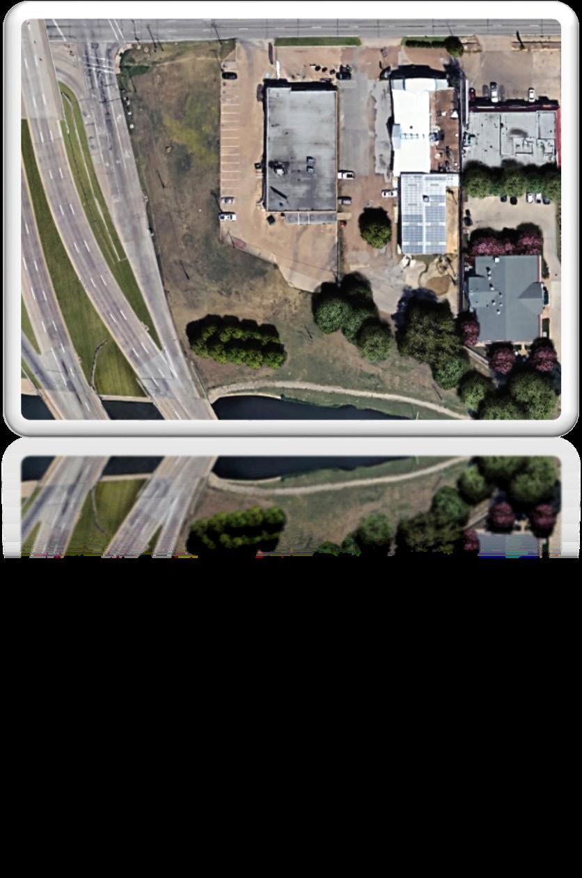
5 5 Existing Site Conditions


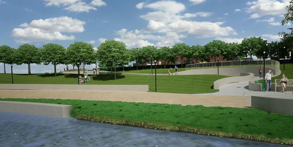
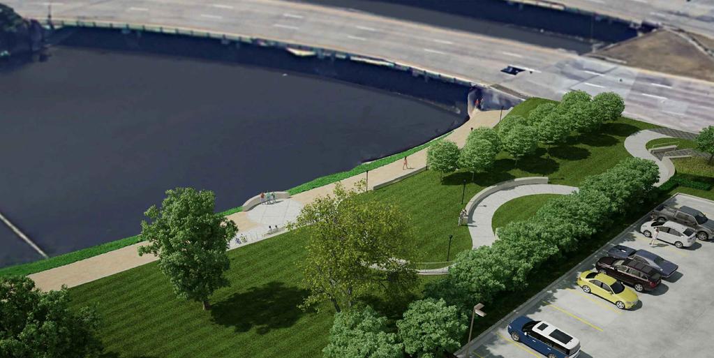
6 Proposed Park Improvements and Design 6

7 Overall Benefits to Bachman and the City of Dallas The Dallas Park Department collaborated with QuikTrip Corporation to develop a plan to renovate this part of the Park (the Plan ). The Plan includes: Lush Landscaping and Irrigation; Parking and Access on Park Premises; Reduced Traffic; Improved Safety Through Night Lighting and 24/7 Surveillance; Zero Negative Environmental Impact; Zero Cost to the City of Dallas. 7


8 Landscaping Currently the Park Property is undeveloped and contains: No landscaping; No irrigation system; No maintenance; No parking; and No designated access to the trailhead of Bachman Creek Trail. 8 As it exists today the Park is little more than a barren piece of forgotten property and does not provide any real use to the City or its citizens.
; 218 Needle Point Holly bushes; Ornamental")

9 Landscaping Subject to change by the Parks Department, the current plan provides for: A beautifully landscaped park; 18 additional trees (three inch caliper); 218 Needle Point Holly bushes; Ornamental grasses; Bermuda sod; Riparian plantings along the creek bed; A drinking water fountain, benches, and bike racks; Improved Greenbelt walkway; and Enhanced walkway along Lemmon Avenue and around the corner onto Northwest Highway. 9


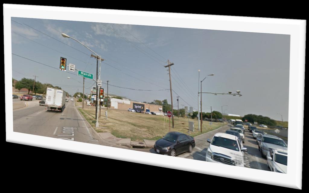
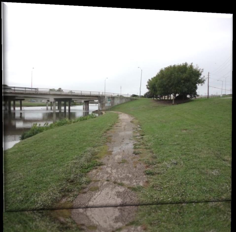
10 Access & Parking There is more to a park than simple green areas. Golf courses, tennis courts, soccer fields, play structures, and nearly any other kind of park in Dallas requires access and parking. This portion of the Park has neither access nor parking. 10
11 Access & Parking This portion of the Park currently has no recognizable access or parking, and part of the reason the Dallas Parks Department has difficulty keeping this part of the Park maintained is that no one can actually use it in its current condition. If you want to access this part of the Park you must either walk from the west side the Park under the Lemmon Avenue Bridge (which is no easy task currently) or use other private parking not designated for the Park. 11 No Access or Parking


12 Access & Parking Are Benefits To provide access and parking, the Plan calls for an access drive from Lemmon Avenue and 29 parking spots on the park property. Additionally, access from the rest of Bachman Creek will be developed through an improved and enlarged walkway under the Lemmon Avenue bridge adjacent to the Park. Access To The Rest of Bachman Access Drive To Lemmon Ave and Parking 12

13 Traffic Reduction As it currently exists this piece of the Park is less than an acre and is an awkwardly shaped lot without any public access to it from Lemmon Avenue. During heavy-traffic hours along the Western boarder of the Park there is significant back-up along Lemmon Avenue, which does not include an eastern turn-only lane. Additionally an eastern turn-only lane from Lemmon Avenue onto Northwest Highway will be built in the current right-of-way which will significantly improve traffic flow at the intersection. The Plan includes the addition of an access drive from Lemmon Avenue into a parking area for those using the Park and allowing people access to the trailhead of Bachman Creek Trail. Turn lane added to fix this gridlock 13


14 Along with providing a pleasant atmosphere, the proposed Plan will illuminate the Park and welcome citizens to safely enjoy the Park and deter unintended and undesirable use of the property. 14 Lighting The Park is currently lit by two standard-issue street lights on telephone poles; one light along Lemmon Avenue and the second at the corner of Lemmon Avenue and Northwest Highway. The condition of the poles and street lights is marginal. There is no lighting along the creek including the path under the Lemmon Avenue Bridge. The Plan provides attractive lighting in the parking area as well as along the creek including under the Lemmon Avenue Bridge. The parking area will have 3 attractive pole lights with low intensity LED bulbs that are shielded so the light casts downward. At the creek walkway there will be 3 lights housed in attractive metal poles along the retaining wall with low intensity LED bulbs. Under the Lemmon Avenue Bridge, a series of lights will be installed along the northern wall of the bridge to illuminate the currently unlit walkway. All of the lighting will be coordinated in an attractive design and be fully compliant with all City photometric, lighting, and glare guidelines and requirements and will remain lit from dusk until dawn.
15 No Cost to the City of Dallas The Parks Department of Dallas does not have the assets (cash or otherwise) to truly develop this part of the Park. Instead, the immediately adjacent neighbor, QuikTrip, has offered to pay for and maintain it, at the direction of the Director of the Parks Department and the Dallas City Council, in part for shared parking but also to improve this part of the Park. The mechanism to document, define, and achieve these results is a Dallas Park Board approved Maintenance Agreement. The Maintenance Agreement includes the following terms: year term; Terminable at will by the City of Dallas; Complete funding of the Project for the initial improvements and the ongoing maintenance at no cost to the City; Ultimate authority for improvements and maintenance at the direction of the City of Dallas and its Parks Department; All of the benefits described herein, including security; and zero environmental impact to the Park.
16 24/7 Security Currently the Park Property is not monitored or patrolled. It is undeveloped park land, has no special status and is not subject to a particular surveillance program. The Park Property will be patrolled by video surveillance 24 hours a day. The video surveillance will be monitored by QuikTrip s internal security department, which is led by a retired US Army Colonel with almost 30 years of security experience. Surveillance video will be maintained and stored for at least 30 days in the event it needs to be reviewed. Issues or disturbances will be reported to the City. The surveillance equipment and its maintenance will be provided to the City pursuant to the Maintenance Agreement at no cost to the City. Citizens who live in a neighborhood approximately 1.5 miles from the Park Property have recently organized a crime watch committee so they could have a coordinated effort to deter crime in their neighborhood. The proposed surveillance provided by the development of the Park Property (along with the lighting plan) dovetails nicely with efforts of the neighborhoods around the Park Property. 16

17 17 24/7 Security and Safety

18 Why QuikTrip? QuikTrip has a history of providing community service to improve areas surrounding its stores, including: Remediation of dozens of 3 rd party contamination sites, including recent projects in both North and South Carolina; Recycling over 2 million pounds of materials since 2014 in Oklahoma; and Retrofitting over 100 stores to conserve water, with prompt plans for more retrofits coming soon. 18

19 Why QuikTrip? QuikTrip is the immediately adjacent neighbor to this portion of the Park. Having already obtained all zoning and other approvals necessary on its property for its convenience store, it will build a convenience store on its property using its newest small store concept in the coming months. Developing this portion of the Park beautifies the Park, allows real use of the Park by the public, increases the aesthetics of both the Park and QuikTrip s property and provides additional parking for the Greenbelt and QuikTrip. 19


20 What Is This Park s Future? Please help us turn this: Into this: 20
Good Neighbor Plan Dallas Love Field Airport Transportation and Environment Committee
 June 25, 2012 Good Neighbor Plan Dallas Love Field Airport Transportation and Environment Committee Overview Vision for Dallas Love Field Downtown Dallas 360 Plan Targeted Improvement Zones Lemmon Avenue
Elm Fork Land Use. Trinity River Corridor Project Committee May 13, 2013
 Elm Fork Land Use Trinity River Corridor Project Committee May 13, 2013 Purpose Discuss Trinity River planned Land Use and Appropriate Compatible Uses, particularly with respect to the Elm Fork Area 2
Errol Heights Park and Community Garden Frequently Asked Questions March 22, 2018
 Errol Heights Park and Community Garden Frequently Asked Questions March 22, 2018 Question 1: What improvements are planned for Errol Heights Park? How will the community be engaged in the process to shape
GENERAL PLAN CONSISTENCY ANALYSIS
 GENERAL PLAN CONSISTENCY ANALYSIS Prepared by Planning Staff 10/28/2013 APPLICABLE GOALS, POLICIES AND PROGRAMS FROM the LAND USE CHAPTER Goal LU-1 Policy LU-1.1 Policy LU-1.2 Goal LU-2 Protect the character
Blue Springs Park. Park Land Established: Developed Acres: 12 acres Undeveloped Acres: 2 acres
 Blue Springs Park Park Location: 2204 SW South Ave. Park Land Established: 1975 Park Size: 14 acres Developed Acres: 12 acres Undeveloped Acres: 2 acres Park Type: Neighborhood Park Amenities: Softball
Park Types and Attributes
 02 APPENDIX B APPENDIX B s and s 194 APPENDIX B 04 Size Level of Service Any privately owned park, of any size, is a neighborhood park Primary Service Area - 1/2 mile or within 15 minutes walking distance
Benedict Fountain Park Meeting Notes Wednesday, February 15, 2012
 Benedict Fountain Park Meeting Notes Wednesday, February 15, 2012 ALTERNATIVE #1 Like the big open lawn space in alternative 1. Like cohesiveness of sidewalk walk and play areas shown on alternative 1
Philip A. Ginsburg, General Manager Dawn Kamalanathan, Director, Planning and Capital Projects
 Date August 5, 2015 To: Through: From: Subject: Recreation and Park Commission Capital Committee Philip A. Ginsburg, General Manager Dawn Kamalanathan, Director, Planning and Capital Projects Nicole Avril,
RESPONSES TO PUBLIC CONCERNS AND QUESTIONS
 RESPONSES TO PUBLIC CONCERNS AND QUESTIONS Stations and Summary Questions for Public Meeting #2 June 23, 2015 General Questions / Concerns: 1. Is there any way this development can raise revenue for the
Campus Master Plan Description Section 6 Storm water management and people places at campus buildings. Section 6 Campus MP Description
 Campus Master Plan Description Section 6 Storm water management and people places at campus buildings Section 6 Campus MP Description THIS PAGE INTENTIONALLY LEFT BLANK. appendix The following provides
MAYFIELD VILLAGE GREENWAY TRAIL
 1 Shared use 10 wide asphalt all purpose trail Includes 60 ft. steel truss bridge, 549 ft. of boardwalk, three underpasses Connects Village center to Library, Metroparks, and Village recreational areas
ENVIRONMENTAL INITIAL STUDY BERKELEY CITYWIDE POOLS MASTER PLAN
 ENVIRONMENTAL INITIAL STUDY FOR THE BERKELEY CITYWIDE POOLS MASTER PLAN CITY OF BERKELEY PARKS RECREATION AND WATERFRONT DEPARTMENT SEPTEMBER 1, 2009 ENVIRONMENTAL INITIAL STUDY BERKELEY CITYWIDE POOLS
Johnson Street Bridge Public Realm Update
 Johnson Street Bridge Public Realm Update August 20, 2015 Background Johnson Street Bridge Replacement Project impacts a diverse range of stakeholders In addition to a new bridge, the project also includes
The transportation system in a community is an
 7 TRANSPORTATION The transportation system in a community is an important factor contributing to the quality of life of the residents. Without a sound transportation system to bring both goods and patrons
WELCOME! MINNEHAHA-HIAWATHA Community Works Project. 46th Street Area Lighting Project July 2009
 WELCOME! MINNEHAHA-HIAWATHA Community Works Project 46th Street Area Lighting Project July 2009 Partners The 46th Street Lighting project is a collaboration between Hennepin County and: The City of Minneapolis
CITY OF GAINESVILLE PARKS, RECREATION AND CULTURAL AFFAIRS DEPARTMENT VISION 2020
 CITY OF GAINESVILLE PARKS, RECREATION AND CULTURAL AFFAIRS DEPARTMENT VISION 2020 A BLUE PRINT FOR THE NEXT 20 YEARS The PRCA Vision 2020 Master Plan, adopted in November 2012, addresses the current state
RTC Visual Impact and Community Character
 Chapter 3.7: RTC Visual Impact and Community Character Comment 3.7-1: Response 3.7-1: The Campus portion of the Proposed Project will not be visible from several of these historic and important community
The following principles guide the development of goals and strategies to protect and promote these amenities:
 OPEN SPACE/PARKS/TRAILS/RECREATION GOALS/STRATEGIES Cherry Hills Village is a living environment that offers low density development, open areas, public scenic vistas, public trails and public parks. This
The Turtle Creek Master Plan- A Summary. July 7, 2011
 The Turtle Creek Master Plan- A Summary July 7, 2011 Background During 2004, TCA commissioned highly regarded Antonio Di Mambro & Associates to create a Master Plan for the Turtle Creek Corridor. The resulting
Chapter 5: Recreation
 Chapter 5: Recreation Introduction and Setting Recreational opportunities within Nevada County are varied, ranging from public parks with intensively used active recreational facilities, to vast tracts
Charles P. Johnson and Associates. Annapolis Landscape Architects
 Charles P. Johnson and Associates Annapolis Landscape Architects AGENDA Introduction Project Limits and Scope Site Analysis Opportunities & Constraints Program Goals Image Boards Design Alternatives Pros
City of Yorba Linda Memorandum
 City of Yorba Linda Memorandum Date: June 15, 2011 Date: To: From: Honorable Chairman and Members of the Parks and Recreation Commission Mike Kudron, Acting Director of Parks and Recreation SUBJECT: BACKGROUND
Improve Neighborhood Design and Reduce Non Point Source Water Pollution
 HOW TO Planning Guide Improve Neighborhood Design and Reduce Non Point Source Water Pollution This document was funded by a grant from the New Hampshire Coastal Program with funding from the National Oceanic
Outdoor Lighting for Julian Dark Sky Network, 2/10/18. Paul Ericson, PE San Diego IDA Board Member / Design Principal, Stantec
 Outdoor Lighting for Julian Dark Sky Network, 2/10/18 Paul Ericson, PE San Diego IDA Board Member / Design Principal, Stantec Introduction to Outdoor Lighting And How it Affects Light Pollution Nighttime
Potential Green Infrastructure Strategies May 6, 2015 Workshop
 Potential Green Infrastructure Strategies May 6, 2015 Workshop Background The City of Cortland is developing the Tioughnioga Urban Headwaters Green Infrastructure Action Plan with funding from the National
The impacts examined herein take into account two attributes of aesthetic values:
 IV. ENVIRONMENTAL IMPACT ANALYSIS This section addresses the potential impacts to views and aesthetics as a result of the proposed Project at the Project Site and the development scenarios analyzed for
Lighting Guidelines. Planning Services Department Corporation of the Municipality of Clarington
 Lighting Guidelines Planning Services Department Corporation of the Municipality of Clarington APPROVED BY COUNCIL ON MARCH 22, 2010 PREFACE In 2005, the area municipalities of Durham Region began the
Town of Cornelius Bond Update August, 2017
 Town of Cornelius Bond Update August, 2017 Referendum Results Roads, Intersections, & Sidewalks ($11.15 mil) Pass rate 81.38% in favor Parks and Recreation ($5.25 mil) Pass rate 72.09% in favor Town Center
2011 ASLA Design Awards. Westside Creeks Restoration Plan Merit Award AECOM, Fort Collins. Planning & Urban Design
 2011 ASLA Design Awards Westside Creeks Restoration Plan Merit Award AECOM, Fort Collins Planning & Urban Design Project Fact Sheet Category of Entry: Rotating Specialty Award: 2011 2011 ASLA Colorado
BIRMINGHAM TOWNSHIP CHESTER COUNTY, PENNSYLVANIA Subdivision and Land Development Ordinance No Dated 02/18/03
 BIRMINGHAM TOWNSHIP CHESTER COUNTY, PENNSYLVANIA Subdivision and Land Development Ordinance No. 0302 Dated 02/18/03 Section 103-40. OUTDOOR LIGHTING A. Purpose. The standards in this section shall require
NORTH COVENTRY TOWNSHIP SUBDIVISION & LAND DEVELOPMENT ORDINANCE LIGHTING
 NORTH COVENTRY TOWNSHIP SUBDIVISION & LAND DEVELOPMENT ORDINANCE LIGHTING Section 628 Lighting Requirements and Design Standards A. Purpose To require and set minimum standards for outdoor lighting to:
West Dennis Center: Bass River to Old Main Street. West Dennis Business District: Old Main Street to Dennis Commons
 West Dennis Center: Bass River to Old Main Street West Dennis Business District: Old Main Street to Dennis Commons Dennisport Center: Dennis Commons to Division Street Main Street Project Goals Project
Parks, and Recreation & Cultural Arts Master Plan Update
 Parks, and Recreation & Cultural Arts Master Plan Update Community Profile Public Input Summary: Staff Interviews conducted April 14 and 15, 2014 Citizens Workshop - conducted April 15 th and 24 th, May
Stafford Township Adopt a Park Program
 Stafford Township Adopt a Park Program Mission Statement: Stafford Township has worked very diligently over the last twenty years to create one of the finest municipal park systems in the state. Our goals
KASPER. City of Georgetown, Texas PUD Planned Unit Development. December 30, 2015 Revised January 27, 2016
 KASPER City of Georgetown, Texas PUD Planned Unit Development December 30, 2015 Revised January 27, 2016 Applicant: Sentinel Land Company, LLC 4910 Campus Drive Newport Beach, CA Prepared by: SEC Planning
Welcome. Northern Segment of Hwy 100 I-90 to South of Madison Street Meeting Goals:
 Welcome Northern Segment of Hwy 100 I-90 to South of Madison Street Meeting Goals: - Review Environmental Assessment - Share Preferred Alternative -Receive Public Comments 2003 EA Preferred Alternative
PRELIMINARY PLAT DESIGN REQUIREMENTS Updated 4/8/2016
 PRELIMINARY PLAT DESIGN REQUIREMENTS Updated 4/8/2016 The following items are required for the preliminary plat. Numbers correspond with those on the example preliminary plat. RENO COUNTY SUBDIVISION REQUIREMENTS
100 Dix Drive Conceptual Master Plan. Wyatt Thompson, PLA, ASLA, Assistant Director Lindsay Stucki, Intern Park Planner
 100 Dix Drive Conceptual Master Plan Wyatt Thompson, PLA, ASLA, Assistant Director Lindsay Stucki, Intern Park Planner Final Draft Prepared August 2018 Introduction On September 20, 2016, the City of Manhattan
12 January 12, 2011 Public Hearing APPLICANT: TAILWIND DEVELOPMENT GROUP,LLC PROPERTY OWNER: CITY OF VIRGINIA BEACH
 12 January 12, 2011 Public Hearing APPLICANT: TAILWIND DEVELOPMENT GROUP,LLC PROPERTY OWNER: CITY OF VIRGINIA BEACH STAFF PLANNER: Faith Christie REQUEST: Conditional Change of Zoning (from PD-H1 Planned
3.1 community vision. 3.3 required plan elements
 Chapter 3 Community Form 3.1 community vision 3.2 Parks & landscaping concepts 3.3 required plan elements D R A F T 20 Community Form Chapter 3 3.0 Community form 3.1 community vision The Specific Plan
W&OD PARK MASTER PLAN. The City s Greenest Street. DRAFT W&OD Trail Master Plan v4.docx Page 1
 W&OD PARK MASTER PLAN Adopted XXX-XX-XXXX The City s Greenest Street DRAFT W&OD Trail Master Plan v4.docx Page 1 Introduction and Purpose The Washington & Old Dominion Railroad Regional Park (W&OD) (which
COMMUNICATION URBAN DESIGN REVIEW BOARD CITY OF DES MOINES, IOWA MAY 16, 2017 MEETING
 COMMUNICATION URBAN DESIGN REVIEW BOARD CITY OF DES MOINES, IOWA MAY 16, 2017 MEETING Subject: Recommendation Prepared by: PRELIMINARY DESIGN REVIEW OF LOCUST STREET BRIDGE CONSTRUCTION & COURT AVENUE,
Policy Statement. Purpose
 Policy Title: Park Trail Lighting Policy Number: 05-02-08 Section: Property and Facilities Subsection: Facility Planning Effective Date: December 18, 2017 Last Review Date: July 2016 Approved by: Council
CY-FAIR ISD Exemplary-rated schools
 -ACRE master planned community GREEN SPACE within a quarter-mile of every home -SQ.FT. community center CY-FAIR ISD Exemplary-rated schools Located in Cypress, Texas, Bridgeland is northwest Houston s
Marshview Park. Concept Briefing and Feedback Session. Aquarium/Owls Creek Plan Steering Committee March 20, 2012
 Marshview Park Concept Briefing and Feedback Session Aquarium/Owls Creek Plan Steering Committee March 20, 2012 1 Outline of Today s Discussion Introductions Context for Marshview Park Site analysis -
SAFETY BY DESIGN Drives Successful Urban Greenways. Brian Charlton - SGJJR Mac McCracken - DRFC
 SAFETY BY DESIGN Drives Successful Urban Greenways Brian Charlton - SGJJR Mac McCracken - DRFC WORLD-CLASS GATHERING PLACE FOR ALL. Detroit Greenways Atwater Street and Rivard Street 2003 Atwater Street
NOTICE OF PREPARATION
 NOTICE OF PREPARATION DATE: January 6, 2016 TO: LEAD AGENCY: Responsible Agencies, Organizations, and Interested Parties Contact: Tyler Barrington, Principal Planner Planning Department Community Development
FORT MISSOULA REGIONAL PARK
 FORT MISSOULA REGIONAL PARK Master Plan Refinement/ Design Development www.missoulaparks.org DHM Design/WGM Group December 3, 2008 Master Plan Report Fort Missoula Regional Park Guiding Principals i 6/14/01
FDOT D4 Complete Streets
 FDOT D4 Complete Streets Context Sensitive Solutions Directs that complete street solutions will complement the context of the community. Collaborative approach to decision making, project development,
Bourne Downtown Site Planning
 Prepared for: The Town of Bourne, MA In Cooperation with: Bourne Financial Development Corporation Prepared by:, Inc. June 24, 2009 Table of Contents Introduction and Summary... 1 Site Existing Conditions...
THE PLANNING AREA 2.1 PLANNING AREA LOCATION
 2. The Planning Area Brisbane Baylands Specific Plan 21 2 THE PLANNING AREA 2.1 PLANNING AREA LOCATION The Baylands is located approximately midway between San Francisco s central business district and
4 C OMMUNITY D ISTRICTS
 4 C OMMUNITY D ISTRICTS N ew development in the Area will include many different types of land uses, including a destination retail area that attracts people from all over the region; recreation opportunities
OPEN SPACE AND RECREATION
 OPEN SPACE AND RECREATION The Town celebrates and maintains the spectacular visual character of our Sonoran Desert setting and we value our open space, mountain views, washes, vegetation, and wildlife.
A.9. Cannon River. Campostella Park. Adjacent Industrial & City Facility Uses
 Campostella Park Classification: Nature Area 14 acres Character: This park is an undeveloped, heavily wooded natural open space park located along the Cannon River, just to the southwest of Babcock Park
a vibrant office and retail development enters the gateway to rutherford county
 a vibrant office and retail development enters the gateway to rutherford county PF UP Introducing Fountains at Gateway in Rutherford County Fountains at Gateway is a new 31-acre Class A multi-tenant office
Guiding Principles. People dance, and to share culture. Place consistency and internal connections. Management community for years to come
 3. The Campus Concept This chapter presents an overview of the Campus Concept from the formulations of its guiding principals through general recommendations to facilitate the triple urban design plan
Wildflowers grow in the new community park on Oakwood Road
 Wildflowers grow in the new community park on Oakwood Road PLANNING AREA - NEW PARKS An important element in the plan for the City of Delafield is to look ahead for future park needs. The City has the
Village of Fair Haven Goals & Objectives
 Village of Fair Haven Goals & Objectives 1 Natural Environmental Quality & Aesthetics Embrace policies and programs that preserve and enhance the Village s natural resources, environment, water quality,
Route 347. New York State Department of Transportation Region 10, Long Island. THE GREENING of ROUTE 347
 The GREENING of Route 347 The Greening of Route 347 The Greening of Route 347: History 3 The Greening of Route 347 4 The Greening of Route 347 5 The Greening of Route 347 Smith Haven Mall 6 The Greening
Asbury Chapel Subdivision Sketch Plan
 Asbury Chapel Subdivision Sketch Plan PART 1: PROJECT SUMMARY Applicant: NVR Inc. Project Size: +/- 76.13 acres Parcel Numbers: 02101112,02116101,02116112, 02116113 Current Zoning: Transitional Residential
South Bend Park. Visioning Plan
 South Bend Park Visioning Plan 2007 South Bend Park, Visioning Program, Executive Summary The South Bend Park Visioning Program began with the receipt of an application from the Friends of South Bend Park,
Project Output Indicators for Federal Gas Tax Investments
 Municipalities are required to report results achieved through the investment of federal Gas Tax funds under the Municipal Funding Agreement. AMO uses the indicators listed below to capture the outputs
Narcoossee Roadway Corridor
 Community Meeting Narcoossee Roadway Corridor April 5, 2012 Meeting Agenda Purpose of Meeting Continuation of Study Update Process (Previous Meetings Oct. & Nov., 2011) Tonight s Objective Review Proposals
Memo Preliminary. City of Miamisburg Parks Site Reconnaissance
 Memo Preliminary To: From: Ms. Rebecca Benna Woolpert, Inc. Date: Subject: City of Miamisburg Parks Site Reconnaissance The consultant team toured the existing Miamisburg Parks to assess current levels
Public Meeting May 20, 2014
 Public Meeting May 20, 2014 Overview Study Purpose Study Area Overview Strategies Potential Opportunities Implementation and Discussion Skeo Solutions Raleigh Walkable Watershed Pilot 2 Purpose Develop
Las Colonias Park Master Plan
 2013 Las Colonias Park Master Plan City of Grand Junction June 2013 Introduction Las Colonias Park, a 101 acre parcel on the edge of the Colorado River south of downtown, was deeded to the City of Grand
CCI Concerned Citizens Group, Inc. Report on Community Survey Regarding Future Use of CCI Property after Cleanup July 1, 2005
 CCI Concerned Citizens Group, Inc. Report on Community Survey Regarding Future Use of CCI Property after Cleanup July 1, 2005 Introduction CCI is a 1.5 acre Superfund site at 320 South Blake Street, Olathe,
5.1 AESTHETICS AND VISUAL RESOURCES Physical Setting
 5.1 AESTHETICS AND VISUAL RESOURCES 5.1.1 Physical Setting Aesthetic values are an important aspect in establishing the identity, sense of place, and quality of life in a community. Natural features in
Design Guidelines for Exterior Lighting
 Design Guidelines for Exterior Lighting Adopted by the Board of Supervisors on January 26, 2016 Design Guidelines for Exterior Lighting 1. Purpose The purpose of the Design Guidelines for Exterior Lighting
Draft Environmental Assessment
 Draft Environmental Assessment CASCADE PARK Orem City, Utah A conversion of land protected under Section 6(f)(3) of the Land and Water Conservation Fund Act, Public Law 108-98 September 2017 For information,
in the IESNA Lighting Handbook and applicable Recommended Practices, except as otherwise required by the Board of Supervisors. 2.
 ROBESON TOWNSHIP AN ORDINANCE OF THE TOWNSHIP OF ROBESON, BERKS COUNTY, PENNSYLVANIA, AMENDING THE ROBESON SUBDIVISION AND LAND DEVELOPMENT ORDINANCE OF 1993 Lighting 11/18/03 Section 519 Lighting Requirements
M E M O R A N D U M January 6, 2017
 Item #4 M E M O R A N D U M January 6, 2017 To: 2035 Corridor Planning Committee From: Kenneth Baker, Sr. Director of Planning and Development Services Subject: Item #4 Overview Fidelis Purpose: Review
The Vision. Photo provided by The Minervini Group. 46 Vision, Objectives & Strategies
 Vision, Objectives & Strategies The is the public framework and guide for future development of the Grand Traverse Commons. The establishes public polices for infrastructure, the preservation of natural
Chapter Master Planned Communities (MPC) District
 District") Sections 14.53.010 Purpose and Intent 14.53.020 Applicability 14.53.030 Procedure 14.53.040 MPC Standards 14.53.050 Required Findings 14.53.010 Purpose and Intent Chapter 14.53 Master Planned Communities
Sections 14.53.010 Purpose and Intent 14.53.020 Applicability 14.53.030 Procedure 14.53.040 MPC Standards 14.53.050 Required Findings 14.53.010 Purpose and Intent Chapter 14.53 Master Planned Communities
Landscape and fencing requirements of this Chapter shall apply to all new landscaped areas.
 Chapter 19.06. Landscaping and Fencing. Sections: 19.06.01. Purpose. 19.06.02. Required Landscaping Improvements. 19.06.03. General Provisions. 19.06.04. Landscaping Plan. 19.06.05. Completion of Landscape
Comanche Creek Greenway IMPROVEMENT PROJECT
 Comanche Creek Greenway IMPROVEMENT PROJECT City of Chico 2012 INTRODUCTION The City of Chico owns approximately 20 acres along Comanche Creek between Midway and the Union Pacific Railroad line, referred
REPORT TO PLANNING COMMISSION
 CITY OF Meeting Date: October 25, 2011 Agenda Item: Community Development Department Planning Division P. O. Box 151560, San Rafael, CA 94915-1560 PHONE: (415) 485-3085/FAX: (415) 485-3184 Case Numbers:
Capital Improvement Program. Development Services Staff Recommended Projects
 2014-2019 Capital Improvement Program Development Services Staff Recommended Projects Ongoing Capital Improvement Ellsworth Road Ryan to Germann Roads $3.5 M Germann Rd Ryan Rd Half-street improvements
Hillsborough County Residential Street Lighting Program
 Hillsborough County Residential Street Lighting Program Public Works HCFLGov.net/PublicWorks (813) 635-5400 Neighborhood street lights in unincorporated Hillsborough County are paid for by property owners
BUILDING SCALE AND SETBACKS 5 ELEMENTS:... 5 FAÇADES (COMMERCIAL/RESIDENTIAL) 5
 5") VISION STATEMENT 3 UTILIZATION OF THE GUIDELINES 3 IMPLEMENTATION 3 PROCEDURES FOR DESIGN REVIEW 3 LAND USE AND ZONING 4 LAND USE 4 ELEMENTS:... 4 ZONING 4 ELEMENTS:... 4 BUILDING SCALE AND SETBACKS 5
VISION STATEMENT 3 UTILIZATION OF THE GUIDELINES 3 IMPLEMENTATION 3 PROCEDURES FOR DESIGN REVIEW 3 LAND USE AND ZONING 4 LAND USE 4 ELEMENTS:... 4 ZONING 4 ELEMENTS:... 4 BUILDING SCALE AND SETBACKS 5
Woods Chapel Park. Park Amenities: Playground, basketball court, single table shelter, small pond and multi-use trail.
 Woods Chapel Park Park Location: 3925 NW Dogwood Park Land Established: 1979 Park Size: 10 acres Developed Acres: 6 acres Undeveloped Acres: 4 acres Park Type: Neighborhood Park Amenities: Playground,
The Illinois Department of Transportation and Lake County Division of Transportation. Route 173, including the Millburn Bypass
 The Illinois Department of Transportation and Lake County Division of Transportation welcome you to this Public Hearing for U.S. Route 45 from Illinois Route 132 to Illinois Route 173, including the Millburn
3.10 LAND USE SETTING PROJECT SITE EXISTING LAND USE DESIGNATIONS AND ZONING. General Plan Land Use Designations.
 This section of the Draft EIR addresses the existing land uses on and adjacent to the project site and discusses the potential impacts of the proposed project on existing land uses. Key issues addressed
Northeast Quadrant Plan
 Northeast Quadrant Plan Northeast Quadrant Distinctive Features Land Use The Northeast Quadrant includes all the area within the planning area that is east of Interstate 5 and to the north of State Route
PARKS & RECREATION SUBCOMMITTEE. Oct. 1, 2015
 PARKS & RECREATION SUBCOMMITTEE Oct. 1, 2015 1999 Bond - $22,000,000 Land Acquisition Allen Station Phase II Neighborhood Parks PREVIOUS BOND ELECTIONS 1999 & 2007 2002 Bond - $4,000,000 Allen Senior Recreation
Developer s Program. The Station at East 54
 Developer s Program The Station at East 54 Existing Conditions The Station at East 54 is proposed for a 1.12 acre site at the northeast corner of Hamilton Road and Prestwick Road, tucked between the East
Smart Growth for Dallas
 Smart Growth for Dallas Using data and GIS to improve the social, economic, and environmental resilience of Dallas Dallas Park and Recreation Board November 1, 2018 About Our Partners The Trust for Public
Enhancing Attawandaron Park
 Enhancing Attawandaron Park # M001 This project idea proposes to involve and empower members of the Attawandaron neighbourhood to get involved in discussions with City staff about ways to enhance the Attawandaron
CHAPTER ADDITIONAL REQUIREMENTS IN THE NC, NEIGHBORHOOD COMMERCIAL ZONE
 CITY OF MOSES LAKE MUNICIPAL CODE CHAPTER 18.31 ADDITIONAL REQUIREMENTS IN THE NC, NEIGHBORHOOD COMMERCIAL ZONE Sections: 18.31.010 Purpose 18.31.020 Minimum Lot Area 18.31.030 Setbacks 18.31.040 Maximum
APPENDIX J PERFORMANCE STANDARDS FOR GRAVEL MINE, PIT MINE, OR QUARRY
 APPENDIX J PERFORMANCE STANDARDS FOR GRAVEL MINE, PIT MINE, OR QUARRY A. Purpose: 1. Regulatory Requirement and Use Mitigation: The purpose of this appendix is to provide a regulatory context (standards)
I-35 CORRIDOR VISION PLAN INTRODUCTION. Purpose. Background
 INTRODUCTION Purpose The Interstate 35-E Corridor Plan is intended to work conjunctively with the 2010 Red Oak Comprehensive Plan to promote positive and quality development and redevelopment along Interstate
Appendix C Park Design Guidelines
 Appendix C Park Design Guidelines The following guidelines apply to the design of parks, open space areas and trails in Talent. These guidelines are based on the need for safe, easily maintained spaces,
Long Branch-Wayne Local Park Renovation Project
 Montgomery Parks Long Branch-Wayne Local Park Renovation Project Community Meeting #2 September 20, 2016 Oak View Elementary School 7:00-9:00 PM Welcome / Team Introductions M-NCPPC (Montgomery Parks)
PUBLIC HEARING. Thursday, December 14, 2017 FDOT Urban Office 2198 Edison Avenue Jacksonville, FL 32204
 DISTRICT TWO PUBLIC HEARING I 10 (SR 8) from I 295 to I 95 Project Development & Environment Study Duval County, Florida Financial Project Number 213326 2 22 01 Efficient Transportation Decision Making
DESIGN OUT CRIME IN NEIGHBORHOODS OF KAUNAS
 DESIGN OUT CRIME IN NEIGHBORHOODS OF KAUNAS Irina Matijosaitiene (Kaunas University of Technology, Lithuania) Violeta Garcia Sotos (Escola Tècnica Superior d'arquitectura de Barcelona) Design out Crime
Sustainable Development Call for Projects
 Sustainable Development Call for Projects 2005-2006 Infrastructure Project Examples *Note: This list is not all inclusive, but a sampling of the types of projects that were awarded funds. 137 Projects
Area-Specific Amendment to Chapter 694 Concerning the Display of Topiary Signs at Woodbine Racetrack. Planning and Growth Management Committee
 PG4.8 STAFF REPORT ACTION REQUIRED Area-Specific Amendment to Chapter 694 Concerning the Display of Topiary Signs at Woodbine Racetrack Date: April 30, 2015 To: From: Wards: Reference Number: Planning
Appendix I-A3 DENAIR COMMUNITY PLAN
 Appendix I-A3 DENAIR COMMUNITY PLAN Adopted by the Stanislaus County Board of Supervisors DECEMBER 15, 1998* *A technical update removing reference to the former Stanislaus County Redevelopment Agency
Section 9 NEIGHBORHOOD DESIGN
 Section 9 NEIGHBORHOOD DESIGN City of Lancaster Comprehensive Plan D u n k i n, S e f k o & A s s o c i a t e s, I n c. NEIGHBORHOOD DESIGN INTRODUCTION There are many ways in which a neighborhood can
PRELIMINARY REPORT. HIGHWAY 18 CORRIDOR NEIGHBORHOOD PLAN VILLAGE OF DOUSMAN November, 2014
 PRELIMINARY REPORT HIGHWAY 18 CORRIDOR NEIGHBORHOOD PLAN VILLAGE OF DOUSMAN November, 2014 This preliminary report presents the initial recommendations for land use within the Highway 18 corridor along